Understanding Pollinator Habitat Conservation under Current Policy Using Economic Experiments

Abstract
1. Introduction
2. Materials and Methods
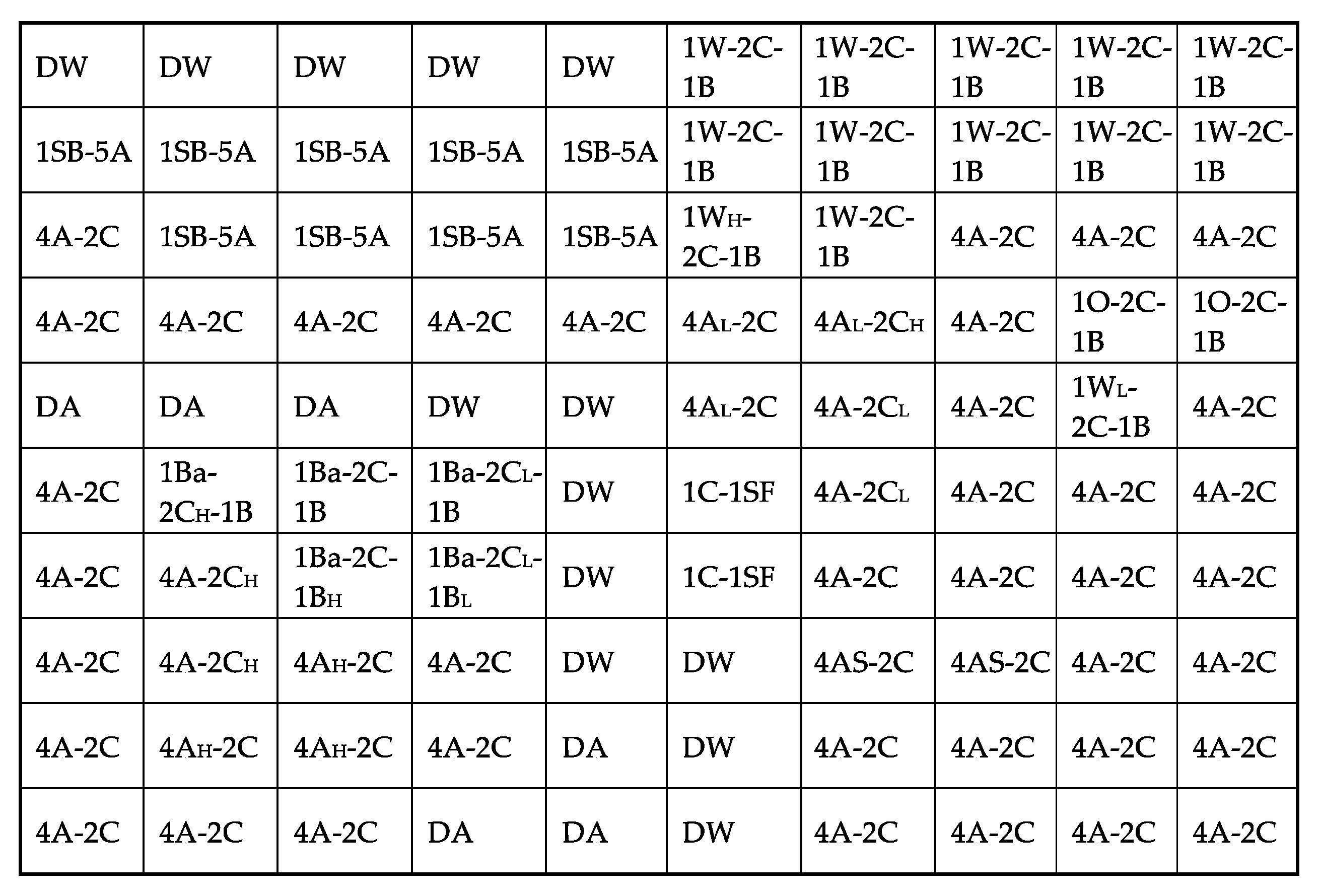
2.1. Land Use, Related Profit Values, and Creation of the Land Decision Grid
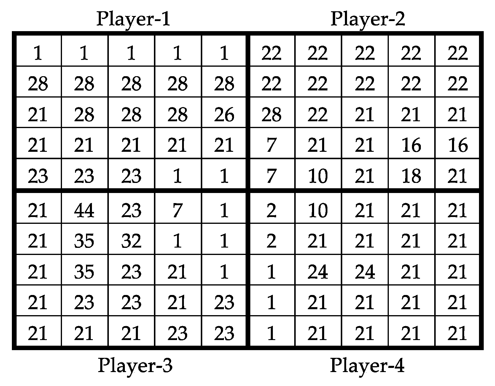
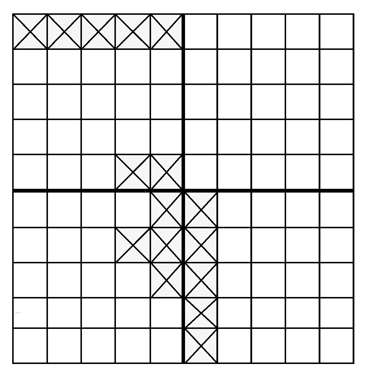
2.2. Experimental Economics Methods
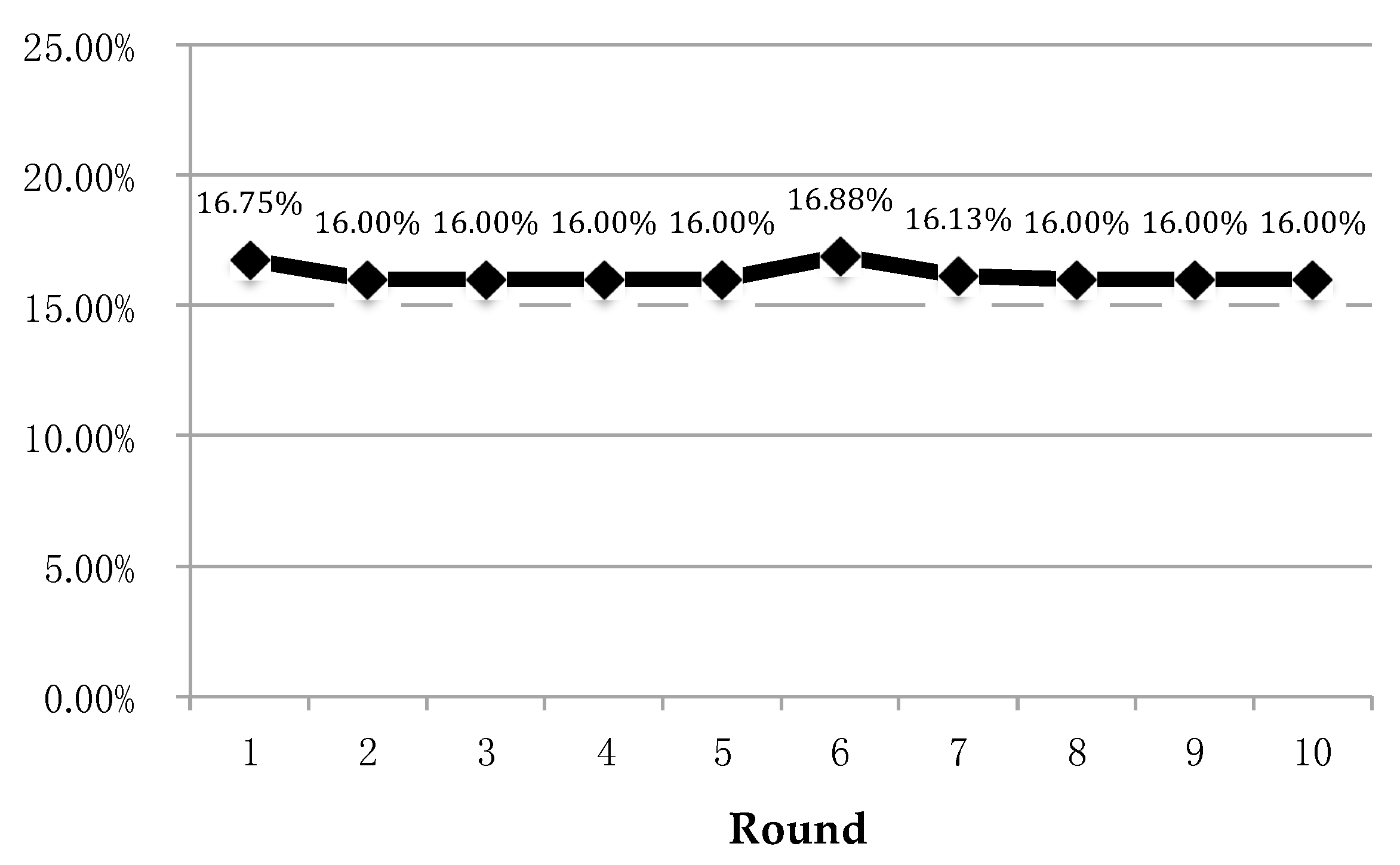
3. Results
4. Discussion
Acknowledgments
Author Contributions
Conflicts of Interest
References
- Aizen, M.; Harder, L. The global stock of domesticated honey bees is growing slower than agricultural demand for pollination. Curr. Biol. 2009, 19, 915–918. [Google Scholar] [CrossRef] [PubMed]
- Goulson, D. Effects of introduced bees on native ecosystems. Annu. Rev. Ecol. Evol. Syst. 2003, 34, 1–26. [Google Scholar] [CrossRef]
- Potts, S.; Biesmeijer, J.; Kremen, C.; Neumann, P.; Schweiger, O.; Kunin, W. Global pollinator declines: Trends, impacts and drivers. Trends Ecol. Evol. 2010, 25, 345–353. [Google Scholar] [CrossRef] [PubMed]
- Kearns, C.; Inouye, D.; Waser, N. Endangered mutualisms: The conservation of plant–pollinator interactions. Annu. Rev. Ecol. Evol. Syst. 1998, 29, 83–112. [Google Scholar] [CrossRef]
- Klein, A.; Vaissiere, B.; Cane, J.; Steffan-Dewenter, I.; Cunningham, S.; Kremen, C.; Tscharntke, T. Importance of pollinators in changing landscapes for world crops. Proc. R Soc. B. 2007, 274, 303–313. [Google Scholar] [CrossRef] [PubMed]
- Zulian, G.; Maes, J.; Paracchini, M.L. Linking land cover data and crop yields for mapping and assessment of pollination services in Europe. Land 2013, 2, 472–492. [Google Scholar] [CrossRef]
- The White House Fact Sheet: The Economic Challenge Posed by Declining Pollinator Populations. Available online: http://www.whitehouse.gov/the-press-office/2014/06/20/fact-sheet-economic-challenge-posed-declining-pollinator-populations (accessed on 5 August 2015).
- United States Department of Agriculture, Agricultural Research Service. Survey Reports Fewer Winter Honey Bee Losses. Available online: http://www.ars.usda.gov/is/pr/2014/140515.htm (accessed on 3 August 2015).
- Goulson, D.; Lye, G.; Darvill, B. Decline and conservation of bumble bees. Ann. Rev. Entomol. 2008, 53, 191–208. [Google Scholar] [CrossRef] [PubMed]
- Koh, I.; Lonsdorf, E.; Williams, N.; Brittain, C.; Isaacs, R.; Gibbs, J.; Ricketts, T. Modeling the Status, trends, and impacts of wild bee abundance in the United States. Proc. Natl. Acad. Sci. USA 2015, 113, 140–145. [Google Scholar] [CrossRef] [PubMed]
- Golick, D.; Ellis, M. An update on the distribution and diversity of Bombus in Nebraska (Hymenoptera: Apidae). J. Kans. Entomol. Soc. 2006, 79, 341–347. [Google Scholar] [CrossRef]
- Tommasi, D.; Miro, A.; Higo, H.; Winston, M. Bee diversity and abundance in an urban setting. Can. Entomol. 2004, 136, 851–869. [Google Scholar] [CrossRef]
- Committee on the Status of Pollinators in North America, National Research Council. Status of Pollinators in North America; The National Academies Press: Washington, DC, USA, 2007; Available online: http://www.nap.edu/catalog/11761.html (accessed on 8 June 2016).
- Vanbergen, A. Insect pollinators initiative. Threats to an ecosystem service: Pressures on pollinators. Front. Ecol. Environ. 2013, 11, 251–259. [Google Scholar] [CrossRef]
- Winfree, R.; Aguilar, R.; Vázquez, D.; LeBuhn, G.; Aizen, M. A meta-analysis of bees’ responses to anthropogenic disturbance. Ecology 2009, 90, 2068–2076. [Google Scholar] [CrossRef] [PubMed]
- Cane, J.H.; Tepedino, V.J. Causes and extent of declines among native North American invertebrate pollinators: Detection, evidence, and consequences. Conserv. Ecol. 2001, 5, 1. [Google Scholar] [CrossRef]
- Blaauw, B.; Isaacs, R. Flower plantings increase wild bee abundance and the pollination services provided to a pollination-dependent crop. J. Appl. Ecol. 2014, 51, 890–898. [Google Scholar] [CrossRef]
- Peterseon, J.; Nault, B. Landscape diversity moderates the effects of bee visitation frequency to flowers on crop production. J. Appl. Ecol. 2014, 52, 1347–1356. [Google Scholar] [CrossRef]
- Roulston, T.; Goodell, K. The role of resources and risks in regulating wild bee populations. Ann. Rev. Entomol. 2011, 56, 293–312. [Google Scholar] [CrossRef] [PubMed]
- Naug, D. Nutritional stress due to habitat loss may explain recent honeybee colony collapses. Biol. Conserv. 2009, 142, 2369–2372. [Google Scholar] [CrossRef]
- Kluser, S.; Peduzzi, P. Global Pollinator Decline: A Literature Review; United Nations Environment Programme: Nairobi, Kenya, 2007. [Google Scholar]
- Goldman, R.; Thompson, B.; Daily, G. Institutional incentives for managing the landscape: Inducing cooperation for the production of ecosystem services. Ecol. Econ. 2007, 64, 333–343. [Google Scholar] [CrossRef]
- United States Environmental Protection Agency. Protecting Bees and Other Pollinators from Pesticides|US EPA. Available online: https://www.epa.gov/pollinator-protection (accessed on 13 July 2015).
- Using Farm Bill Programs for Pollinator Conservation: Technical Note No. 88. Available online: https://plants.usda.gov/pollinators/Using_Farm_Bill_Programs_for_Pollinator_Conservation.pdf (accessed on 17 March 2017).
- United States Department of Agriculture, Farm and Foreign Agricultural Services. Conservation Reserve Program. (CRP) Maintaining Beehives on CRP Acreage. Available online: http://www.fsa.usda.gov/Internet/FSA_File/7722287_honey_bees.pdf (accessed on 5 April 2015).
- United States Department of Agriculture, Farm Service Agency. Pollinators. Available online: https://www.fsa.usda.gov/programs-and-services/economic-and-policy-analysis/natural-resources-analysis/pollinators/index (accessed on 10 June 2017).
- Rashford, B.S.; Walker, J.A.; Bastian, C.T. Economics of grassland conversion to cropland in the Prairie Pothole Region. Conserv. Biol. 2010, 25, 276–284. [Google Scholar] [CrossRef] [PubMed]
- Rashford, B.S.; Bastian, C.T.; Cole, J.G. Agricultural land-use change in prairie Canada: Implications for wetland and waterfowl habitat conservation. Can. J. Agric. Econ. 2011, 59, 185–205. [Google Scholar] [CrossRef]
- United States Department of Agriculture, National Agricultural Statistics Service. Wyoming Agricultural Statistics; 2012. Available online: https://www.nass.usda.gov/Statistics_by_State/Wyoming/Publications/Annual_Statistical_Bulletin/ (accessed on 4 June 2016).
- United States Department of Agriculture, National Agricultural Statistics Service. Annual Statistical Bulletin; 2014. Available online: https://www.nass.usda.gov/Statistics_by_State/Wyoming/Publications/Annual_Statistical_Bulletin/WY_2014_Bulletin.pdf (accessed on 4 June 2015).
- University of Nebraska-Lincoln, Institute of Agriculture and Natural Resources. Nebraska Crop Budgets. 2013. Available online: http://cropwatch.unl.edu/economics/budgets (accessed on 11 June 2015).
- Lee, B.; Ritten, J.; Kniss, A.; Bastian, C. Profitability comparison for glyphosate-resistant and conventional sugarbeet production systems. J. Sugar Beet. Res. 2014, 51, 2–13. [Google Scholar] [CrossRef]
- Parkhurst, G.; Shogren, J. Spatial incentives to coordinate contiguous habitat. Ecol. Econ. 2007, 64, 344–355. [Google Scholar] [CrossRef]
- Banerjee, S.; Kwasnica, A.; Shortle, J. Agglomeration bonus in small and large local networks: A laboratory examination of spatial coordination. Ecol. Econ. 2012, 84, 142–152. [Google Scholar] [CrossRef]
- Banerjee, S.; de Vries, F.; Hanley, N.; van Soest, D. The impact of information provision on agglomeration bonus performance: An experimental study on local networks. Am. J. Agric. Econ. 2014, 96, 1009–1029. [Google Scholar] [CrossRef]
- Bastian, C.T.; Menkhaus, D.J.; Nagler, A.M.; Ballenger, N.S. Ex ante evaluation of alternative agricultural policies in laboratory posted bid markets. Am. J. Agric. Econ. 2008, 90, 1208–1215. [Google Scholar] [CrossRef]
- Falk, A.; Heckman, J.J. Lab experiments are a major source of knowledge in the social sciences. Science 2009, 326, 535–538. [Google Scholar] [CrossRef] [PubMed]
- Samuelson, L. Economic theory and experimental economics. J. Econ. Lit. 2005, 43, 65–107. [Google Scholar] [CrossRef]
- Friedman, D.; Sunder, S. Experimental Methods: A Primer for Economists; Cambridge University Press: New York, NY, USA, 1994. [Google Scholar]
- Parkhurst, G.; Shogren, J.; Bastian, C.; Kivi, P.; Donner, J.; Smith, R. Agglomeration bonus: An incentive mechanism to reunite fragmented habitat for biodiversity conservation. Ecol. Econ. 2002, 41, 305–328. [Google Scholar] [CrossRef]
- Nagler, A.M.; Menkhaus, D.J.; Bastian, C.T.; Ehmke, M.D.; Coatney, K.T. Subsidy incidence in factor markets: An experimental approach. J. Agric. Appl. Econ. 2013, 45, 17–33. [Google Scholar] [CrossRef]
- Levitt, S.D.; List, J.A. What do laboratory experiments measuring social preferences reveal about the real world? J. Econ. Perspect. 2007, 21, 153–174. [Google Scholar] [CrossRef]
- Armsworth, P.R.; Daily, G.C.; Kareiva, P.; Sanchirico, J.N. Land market feedbacks can undermine biodiversity conservation. Proc. Natl. Acad. Sci. USA 2006, 103, 5403–5409. [Google Scholar] [CrossRef] [PubMed]


| Crop Rotations | Percentage of Total Cropland |
|---|---|
| 4 years irrigated alfalfa, 2 years corn | 48 |
| Dry wheat | 13 |
| 1 year winter wheat, 2 years corn, 1 year dry bean | 13 |
| 1 year sugar beet, 5 years irrigated alfalfa | 9 |
| Dry alfalfa | 6 |
| 1 year barley, 2 years corn, 1 year dry beans | 5 |
| 1 year oats, 2 years corn, 1 year dry beans | 2 |
| 1 year corn, 1 years sunflower | 2 |
| 4 years alfalfa seed, 2 years corn | 2 |
| Crops | Profits per Year ($ per Acre) |
|---|---|
| Dry beans (high profit) | 883.22 |
| Sugar beets | 829.31 |
| Corn (high profit) | 807.21 |
| Winter wheat (high profit) | 507.20 |
| Dry beans | 409.45 |
| Alfalfa (high profit) | 307.97 |
| Dry alfalfa | 293.40 |
| Alfalfa | 273.66 |
| Barley | 267.10 |
| Corn | 262.47 |
| Winter wheat | 188.18 |
| Dry beans (low profit) | 54.14 |
| Dry wheat | 3.00 |
| Alfalfa (low profit) | 0.00 |
| Winter wheat (low profit) | −0.30 |
| Sun flower | −14.49 |
| Oats | −119.74 |
| Corn (low profit) | −137.53 |
| Crop Rotations | Profits per Year ($ per Acre) | NPVs per Eighth Section ($) |
|---|---|---|
| 1 year barley, 2 years high profit corn, 1 year dry beans (1Ba-2CH-1B) | 572 | 4423 |
| 4 years alfalfa, 2 years high profit corn (4A-2CH) | 452 | 3487 |
| 1 year barley, 2 years corn, 1 year high profit dry beans (1Ba-2C-1BH) | 419 | 3234 |
| 1 year sugar beet, 5 years alfalfa (1SB-5A) | 366 | 2828 |
| 1 year high profit winter wheat, 2 years corn, 1 year beans (1WH-2C-1B) | 360 | 2783 |
| 4 year alfalfa seed, 2 years corn (2AS-2C) | 307 | 2372 |
| 1 year barley, 2 years corn, 1 year dry beans (1Ba-2C-1B) | 300 | 2320 |
| Always dry alfalfa (DA) | 293 | 2266 |
| 4 years high profit alfalfa, 2 years corn (4AH-2C) | 294 | 2261 |
| 1 years winter wheat, 2 years corn, 1 year beans (1W-2C-1B) | 281 | 2167 |
| 4 years alfalfa, 2 years corn (4A-2C) | 270 | 2085 |
| 4 years low profit alfalfa, 2 years high profit corn (4AL-2CH) | 269 | 2078 |
| 1 years low profit winter wheat, 2 years corn, 1 year beans (1WL-2C-1B) | 234 | 1803 |
| 1 year oats, 2 years corn, 1 year beans (1O-2C-1B) | 204 | 1573 |
| 4 years alfalfa, 2 years low profit corn (4A-2CL) | 137 | 1055 |
| 1 year barley, 2 years low profit corn 1 year dry beans (1Ba-2CL-1B) | 100 | 775 |
| 4 years low profit alfalfa, 2 years corn (4AL-2C) | 87 | 675 |
| 1 year corn, 1 year sunflowers (1C-1S) | 22 | 174 |
| 1 year barley, 2 years low profit corn, 1 year low profit dry beans (1Ba-2CL-1BL) | 12 | 89 |
| Always dry wheat (DW) | 3 | 23 |
| Crop Rotations Practiced Prior to Enrollment | Number of Acres Enrolled per 8000 Acres Cropland |
|---|---|
| Dry wheat | 1040 |
| 1 year barley, 2 years low profit corn, 1 year low profit dry bean | 80 |
| 1 year corn, 2 years sun flower | 160 |
© 2017 by the authors. Licensee MDPI, Basel, Switzerland. This article is an open access article distributed under the terms and conditions of the Creative Commons Attribution (CC BY) license (http://creativecommons.org/licenses/by/4.0/).
Share and Cite
Jones Ritten, C.; Bastian, C.; Shogren, J.F.; Panchalingam, T.; Ehmke, M.D.; Parkhurst, G. Understanding Pollinator Habitat Conservation under Current Policy Using Economic Experiments. Land 2017, 6, 57. https://doi.org/10.3390/land6030057
Jones Ritten C, Bastian C, Shogren JF, Panchalingam T, Ehmke MD, Parkhurst G. Understanding Pollinator Habitat Conservation under Current Policy Using Economic Experiments. Land. 2017; 6(3):57. https://doi.org/10.3390/land6030057
Chicago/Turabian StyleJones Ritten, Chian, Christopher Bastian, Jason F. Shogren, Thadchaigeni Panchalingam, Mariah D. Ehmke, and Gregory Parkhurst. 2017. "Understanding Pollinator Habitat Conservation under Current Policy Using Economic Experiments" Land 6, no. 3: 57. https://doi.org/10.3390/land6030057
APA StyleJones Ritten, C., Bastian, C., Shogren, J. F., Panchalingam, T., Ehmke, M. D., & Parkhurst, G. (2017). Understanding Pollinator Habitat Conservation under Current Policy Using Economic Experiments. Land, 6(3), 57. https://doi.org/10.3390/land6030057