The Influence of Geology on Landscape Typology in Jordan: Theoretical Understanding and Planning Implications


Abstract
:1. Introduction
2. Background information
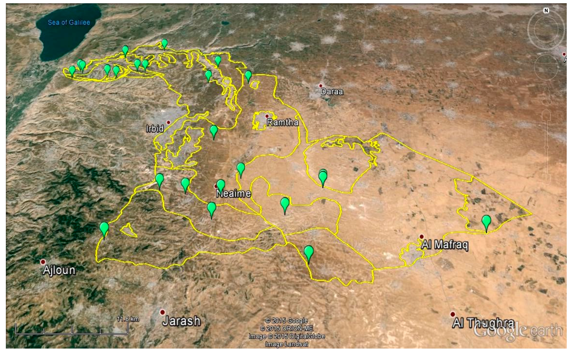
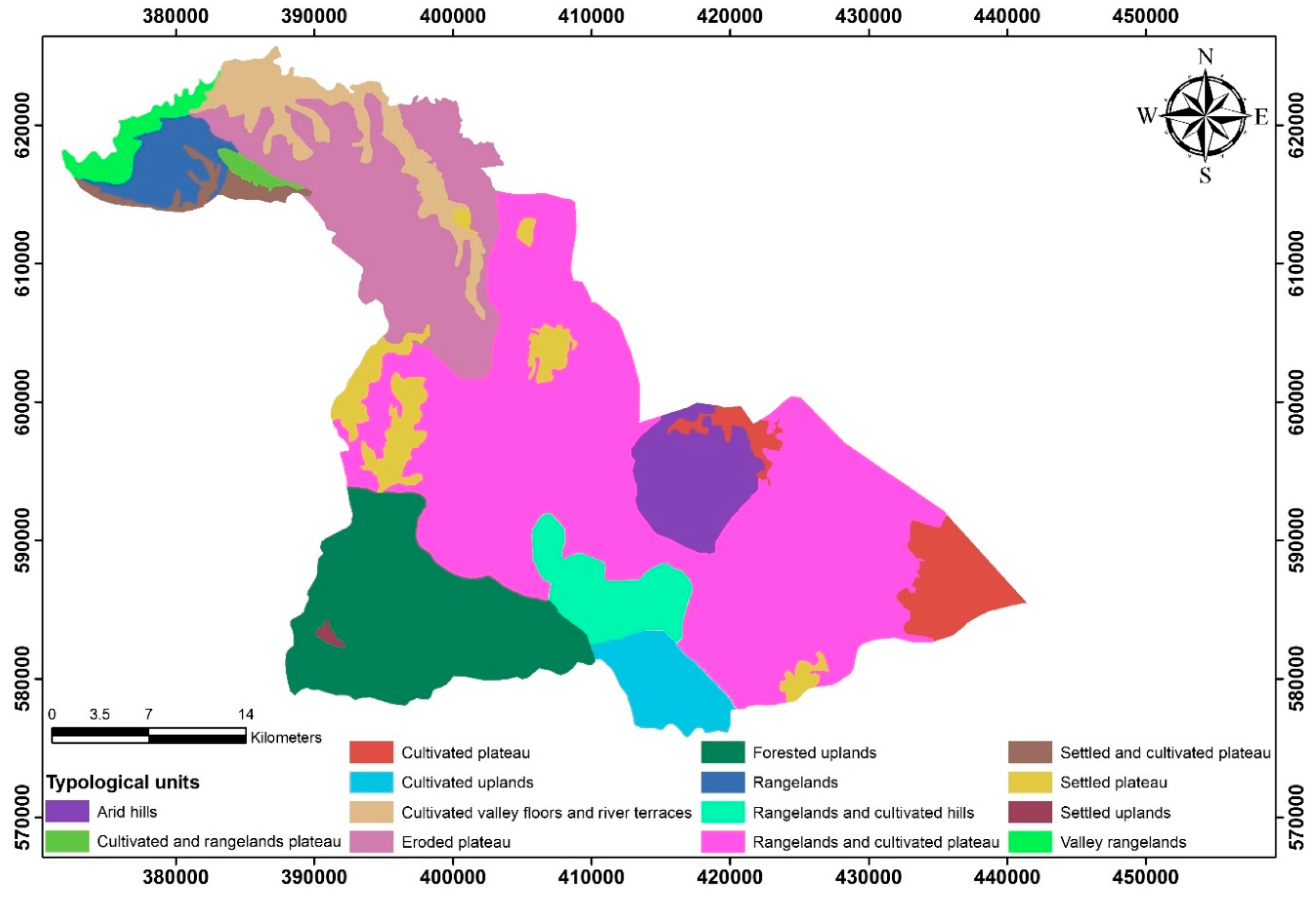
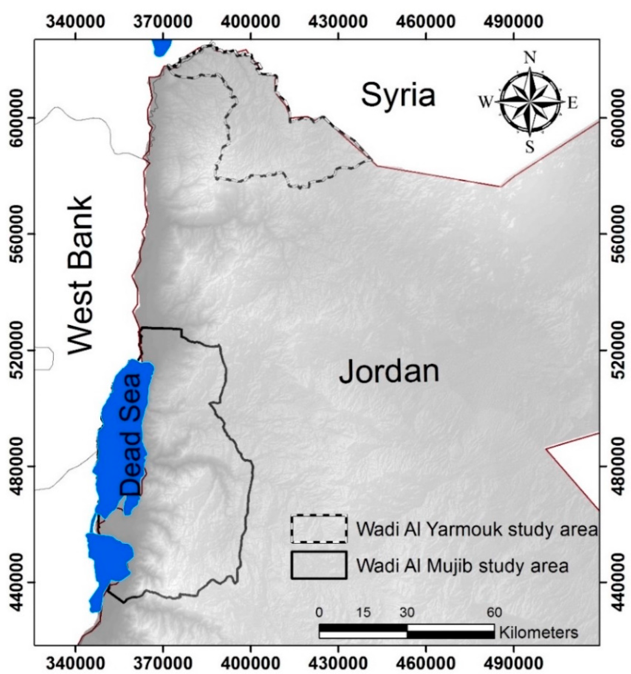
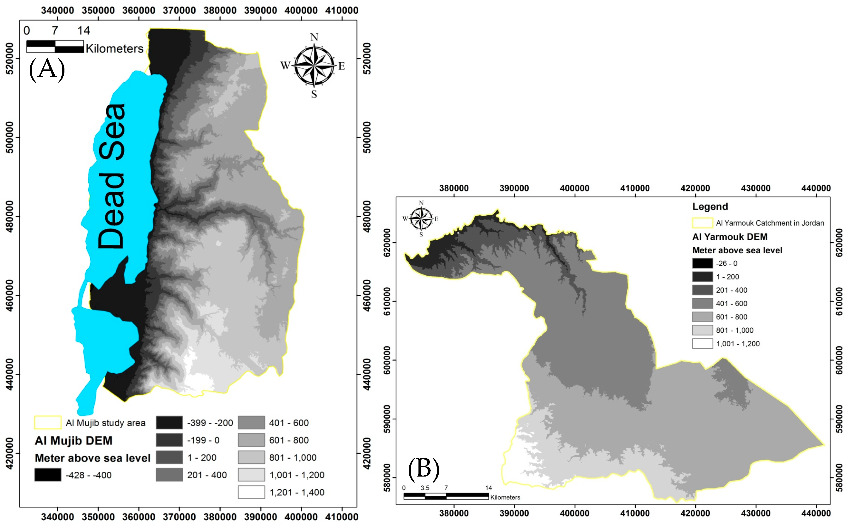
2.1. The Yarmouk River Basin
2.2. Wadi Mujib River Basin
3. Methodology
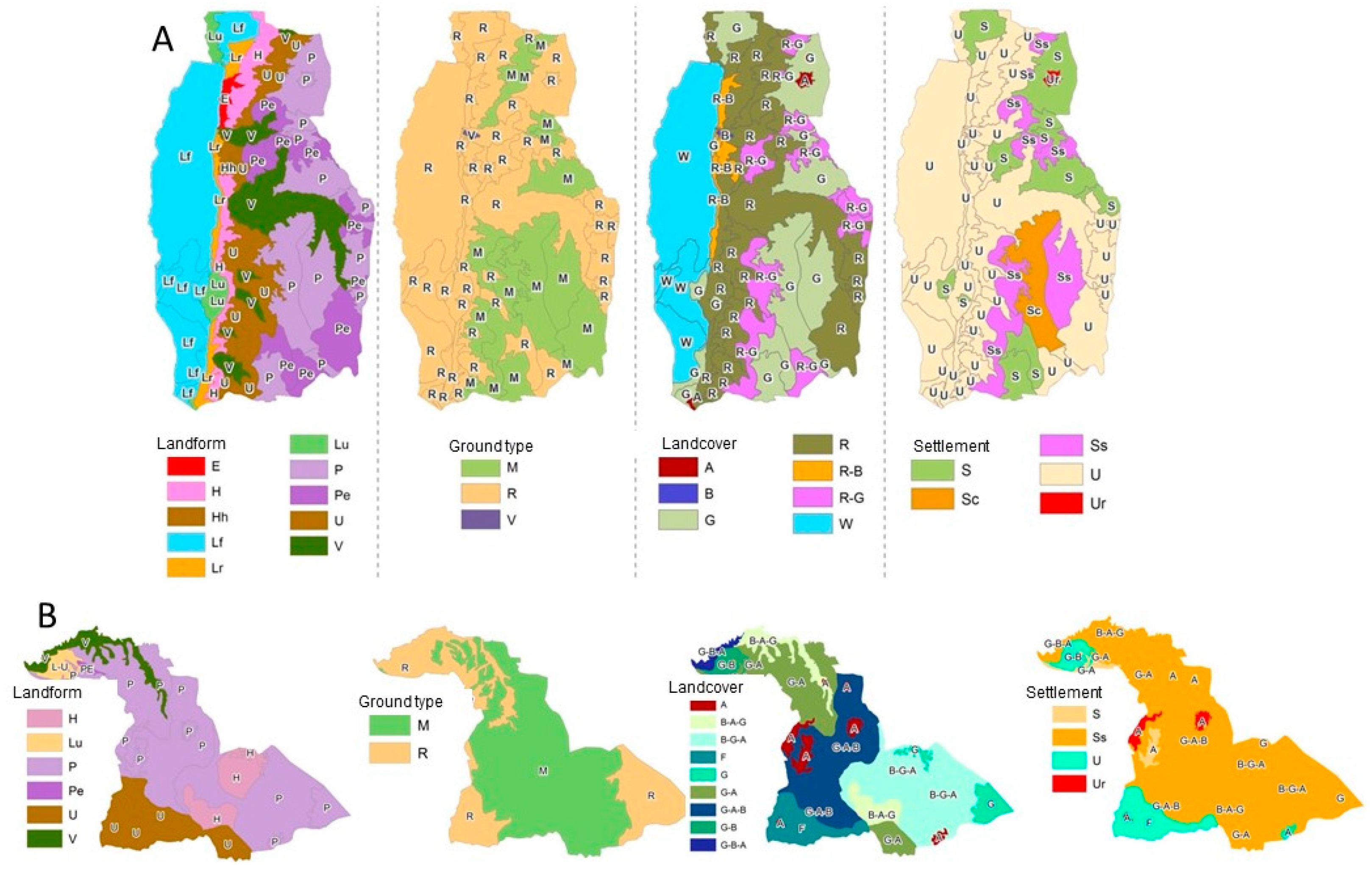
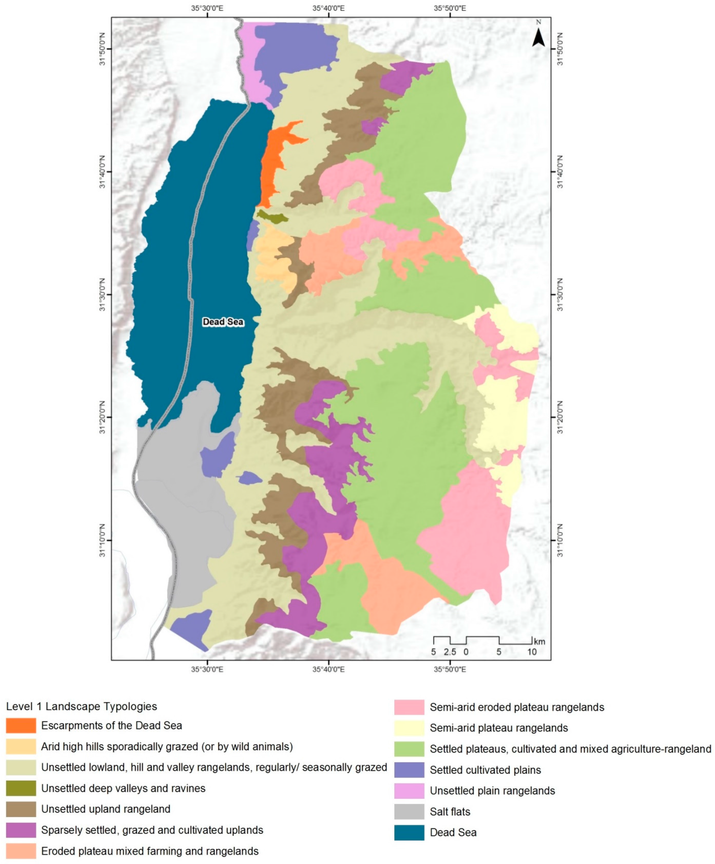
4. Results and Discussion
5. Conclusion and Recommendations
5.1. In the Wadi Mujib study area:
5.2. In the Wadi Yarmouk study area:
Acknowledgments
Author Contributions
Conflicts of Interest
References
- Abu-Jaber, N. Jordan and the Environmental Challenge (الاردن و التحدي البيئي); Dar Al Shorouk publishers, Amman, with support from the Ministry of Culture: Amman, Jordan, 2010; p. 216. (In Arabic) [Google Scholar]
- Potter, R.B.; Darmame, K.; Barham, N.; Nortcliff, S. “Ever-growing Amman”, Jordan: Urban expansion, social polarisation and contemporary urban planning issues. Habitat Int. 2009, 33, 81–92. [Google Scholar] [CrossRef]
- Al-Eisawi, D. Vegetation of Jordan; UNESCO- Regional Office for Science and Technology for the Arab States: Cairo, Egypt, 1996. [Google Scholar]
- Beauregard, R.A.; Marpillero-Colomina, A. More than a master plan: Amman 2025. Cities 2011, 28, 62–69. [Google Scholar] [CrossRef]
- Department of Statistics. Statistical Yearbook; Government publication: Amman, Jordan, 2014; Chapter 5; p. 200.
- Tarabieh, S. Sustainable Spatial Planning Constraints in Al-me’raad Watershed, Jordan. Unpublished M.Sc. Thesis, German Jordanian University, Amman, Jordan, 2015. [Google Scholar]
- Abu-Jaber, N.; Abunnasr, Y.; Yahya, A.A.; Boulad, N.; Christou, O.; Dimitropoulos, G.; Gkoltsiou, K.; Khreis, N.; Manolaki, P.; Michael, K.; et al. Travelling in the eastern Mediterranean with landscape character assessment. In Proceedings of the Third International Conference on Remote Sensing and Geoinformation of the Environment, Paphos, Cyprus, 16–19 March 2015. [Google Scholar]
- Perdew, L. Understanding Jordan Today; Mitchell Lane Publishers, Inc.: Newark, DE, USA, 2014; pp. 17–18. [Google Scholar]
- Bender, F. Geology of Jordan. Contribution of the Regional Geology of the Earth; Borntraeger: Berlin, Germany, 1974; p. 196. [Google Scholar]
- Moshrik, H.R.; Abu-Allaban, M.; Al-Shayeb, A. Climate change in Jordan: A comprehensive examination approach. Am. J. Environ. Sci. 2009, 5, 58–68. [Google Scholar]
- Odeh, T.; Rödiger, T.; Geyer, S.; Schirmer, M. Hydrological modelling of a heterogeneous catchment using an integrated approach of remote sensing, a geographic information system and hydrologic response units: The case study of Wadi Zerka Ma’in catchment area, north east of the Dead Sea. Environ. Earth Sci. 2014, 73, 3309–3326. [Google Scholar] [CrossRef]
- Odeh, T.; Gloaguen, R.; Schirmer, M.; Geyer, S.; Rödiger, T.; Siebert, C. Investigation of catchment areas migrations through a sinstral and dextral strike slip faults: The case study of Zerka Ma’in and Al Hasa catchment areas, East of the Dead Sea in Jordan. In Proceedings of the 4 ASME/WSEAS International conference on geology and Seismology (GES’10), Cambridge, UK, 23–25 February 2010; pp. 120–126. [Google Scholar]
- Salameh, E.; Bannayan, H. Water Resources of Jordan—Present Status and Future Potentials; Friedrich Ebert Stiftung: Amman, Jordan, 1993. [Google Scholar]
- Abu-Jaber, N.S.; Kimberley, M.M.; Cavaroc, V.V. Mesozoic-Palaeogene basin development within the Eastern Mediterranean borderland. J. Petrol. Geol. 1989, 4, 419–436. [Google Scholar] [CrossRef]
- Dunne, T. Evaluation of Erosion Conditions and Trends; FAO Conservation Guide: Rome, Italy, 1977; pp. 53–83. [Google Scholar]
- Kam, T. Integrating GIS and remote sensing techniques for urban land-cover and landuse analysis. Geocarto Int. 1995, 10, 39–49. [Google Scholar]
- Swanwick, C.; Land Use Consultants 2002. Landscape Character Assessment: Guidance for England and Scotland; The Countryside Agency/Edinburgh; Scottish Natural Heritage: Cheltenham, UK, 2002. [Google Scholar]
- Zube, E.; Sell, J.; Taylor, J. Landscape perception: Research, application and theory. Landsc. Plan. 1982, 9, 1–33. [Google Scholar] [CrossRef]
- Chou, Y. Exploring Spatial Analysis in GIS; Onword Press: New York, NY, USA, 1997; p. 500. [Google Scholar]
- Brabyn, K. Solutions for characterizing natural landscapes using Geographical Information Systems. J. Environ. Manag. 2005, 76, 23–34. [Google Scholar] [CrossRef] [PubMed]
- Dodsworth, E.; Nicholson, A. Academic Uses of Google Earth and Google Maps in a Library Setting. Inf. Technol. Libr. 2012, 31, 32–36. [Google Scholar] [CrossRef]
- Giles, R.; Trani, M. Key elements of landscape pattern measures. Environ. Manag. 1999, 23, 477–481. [Google Scholar]
- Kepner, W.; Watts, C.; Edmonds, C. A landscape approach for detecting and evaluating change in a semi-arid environment. Environ. Monit. Assess. 2002, 64, 179–195. [Google Scholar] [CrossRef]
- Gustafson, E. Quantifying landscape spatial pattern: What is the state-of-the-art? Ecosystems 1998, 1, 143–156. [Google Scholar] [CrossRef]
- Ferguson, B. Landscape hydrology. J. Environ. Syst. 1991, 21, 193–206. [Google Scholar] [CrossRef]
- Lausch, A.; Herzog, F. Applicability of landscape metrics for the monitoring of landscape change: Issues of scale, resolution and interpretability. Ecol. Indic. 2002, 2, 3–15. [Google Scholar] [CrossRef]
- Horowitz, A. The Jordan Rift Valley; Ballkema: Rotterdam, The Netherlands, 2001; p. 730. [Google Scholar]
- Keller, E.A.; Pinter, N. Active Tectonics: Earthquakes and Landscape; Prentice-Hall: Upper Saddle River, NJ, USA, 2002; p. 362. [Google Scholar]
- Abu-Jaber, N.; Kharabsheh, A. Ground water origin and movement in the upper Yarmouk Basin, Northern Jordan. Environ. Geol. 2008, 54, 1355–1365. [Google Scholar] [CrossRef]
- Niemi, T.; Ben-Avraham, Z. The Dead Sea: The Lake and Its Setting Monographs on Geology 442 and Geophysics Press 36; Oxford University: New York, NY, USA, 1997; pp. 326–336. [Google Scholar]
- Closson, D.; Karaki, N.A.; Klinger, Y.; Hussein, M.J. Subsidence and sinkhole hazard assessment in the southern Dead Sea area, Jordan. Pure Appl. Geophys. 2005, 162, 221–248. [Google Scholar] [CrossRef]
- Al Qudah, K.; Abu-Jaber, N.; Jaradat, R.; Awawdeh, M. Artificial rainfall tests, soil moisture profiles and geoelectrical investigations for the estimation of recharge rates in a semi-arid area (Jordanian Yarmouk River Basin). Environ. Earth Sci. 2015, 73, 6677–6689. [Google Scholar] [CrossRef]


| Landform | Description | Code |
|---|---|---|
| Lowlands | Areas of land generally lying less than 200 m above the drainage base-level. These can be further characterized as flat (<2% slope or 1:50), undulating to gently undulating (2–10%, 1:50–1:10), or rolling to strongly rolling(10–50%, 1:10–1:2) | Lf |
| Lu | ||
| Lr | ||
| Hills | Somewhat elevated tracts of land (around 200–600 m above) but also usually rolling slopes (10–50%) | H |
| High Hills | Somewhat elevated tracts of land (around 400–900 m above base-level) * but also steeply rolling to precipitous (>50%) | Hh |
| Uplands | Elevated and often extensive tracts of land with variable relief. Generally between 600–1000 m above base level | U |
| Mountainous area | Elevated tracts of land. Generally >1000 m and typically showing peaks, ridges, and steep or precipitous slopes | M |
| Plateau | The essential criteria for plateaus are low relative relief (extensive area of flat) and some altitude (e.g., over 200 m) | P |
| Eroded Plateau | Extensive areas of elevated land, undulating to rolling, often with dendritic drainage patterns | Pe |
| Valleys | An elongated hollow between hills or ridges. A stretch of a land watered by a river (at least seasonally) and enclosed or flanked by its erosion slopes | V |
| Escarpment | Extensive area at any altitude with average slope angles >50%. Often includes cliffs and rock outcrops | E |
| Soil Class | Code |
|---|---|
| Mixed Soils | M |
| Shallow Soils over chalk and limestone | R |
| Volcanic | V |
| Class | Description | Code |
|---|---|---|
| Artificial surfaces | Urban; industrial, commercial and transport units; mine, dump and construction sites; artificial non-agricultural vegetated areas. | A |
| Agriculture | Arable land, permanent crops, horticultural crops, , enclosed pastures, mixed agriculture. | G |
| Forest | Natural forests; Artificial forest (plantations). | F |
| Scrub | Includes maquis, garrigue and other mixed scrub. Typically sclerophyl shrub species attaining 1m+ in height. | S |
| Rangelands and rough grazing | Dwarf scrub, hedgehog scrub, phrygana often mixed with annual grasses and herbs , typically grazed by free-ranging goats and/or sheep. Vegetation usually <0.5 m in height., of aromatic, xerophytic and drought-adapted shrub species. | R |
| Bare land | Land with exposed bedrock, boulders, rocks, gravel etc with virtually no vegetation nor any specific clear use. | B |
| Wetlands& Water Bodies | Inland wetlands like marshes and peat bogs; coastal wetlands like salt marshes, salines and intertidal flats. Inland waters like water courses and water bodies; and marine waters like estuaries, and coastal lagoons. | W |
| Mixture of rangeland and bareland | Mixed landcover of rangeland and bare lands. | R-B |
| Mixture of rangeland and agriculture | Mixed landcover of rangeland and agriculture lands. | R-G |
| Class | Description | Code |
|---|---|---|
| Unsettled | Areas with no settlements | U |
| Sparsely Settled | The typical distance between neighboring settlements is 5 km or more | Ss |
| Settled | The typical distance between neighboring settlements is less than 5 km | S |
| Urban | Cities, and other large built up areas greater than 10 km2 in extent | Ur |
© 2017 by the authors. Licensee MDPI, Basel, Switzerland. This article is an open access article distributed under the terms and conditions of the Creative Commons Attribution (CC BY) license (http://creativecommons.org/licenses/by/4.0/).
Share and Cite
Odeh, T.; Boulad, N.; Abed, O.; Abu Yahya, A.; Khries, N.; Abu-Jaber, N. The Influence of Geology on Landscape Typology in Jordan: Theoretical Understanding and Planning Implications. Land 2017, 6, 51. https://doi.org/10.3390/land6030051
Odeh T, Boulad N, Abed O, Abu Yahya A, Khries N, Abu-Jaber N. The Influence of Geology on Landscape Typology in Jordan: Theoretical Understanding and Planning Implications. Land. 2017; 6(3):51. https://doi.org/10.3390/land6030051
Chicago/Turabian StyleOdeh, Taleb, Natalia Boulad, Omar Abed, Anas Abu Yahya, Nour Khries, and Nizar Abu-Jaber. 2017. "The Influence of Geology on Landscape Typology in Jordan: Theoretical Understanding and Planning Implications" Land 6, no. 3: 51. https://doi.org/10.3390/land6030051
APA StyleOdeh, T., Boulad, N., Abed, O., Abu Yahya, A., Khries, N., & Abu-Jaber, N. (2017). The Influence of Geology on Landscape Typology in Jordan: Theoretical Understanding and Planning Implications. Land, 6(3), 51. https://doi.org/10.3390/land6030051