
Prediction of Land Use Change in Long Island Sound Watersheds Using Nighttime Light Data


Abstract
:1. Introduction
2. Materials and Methods
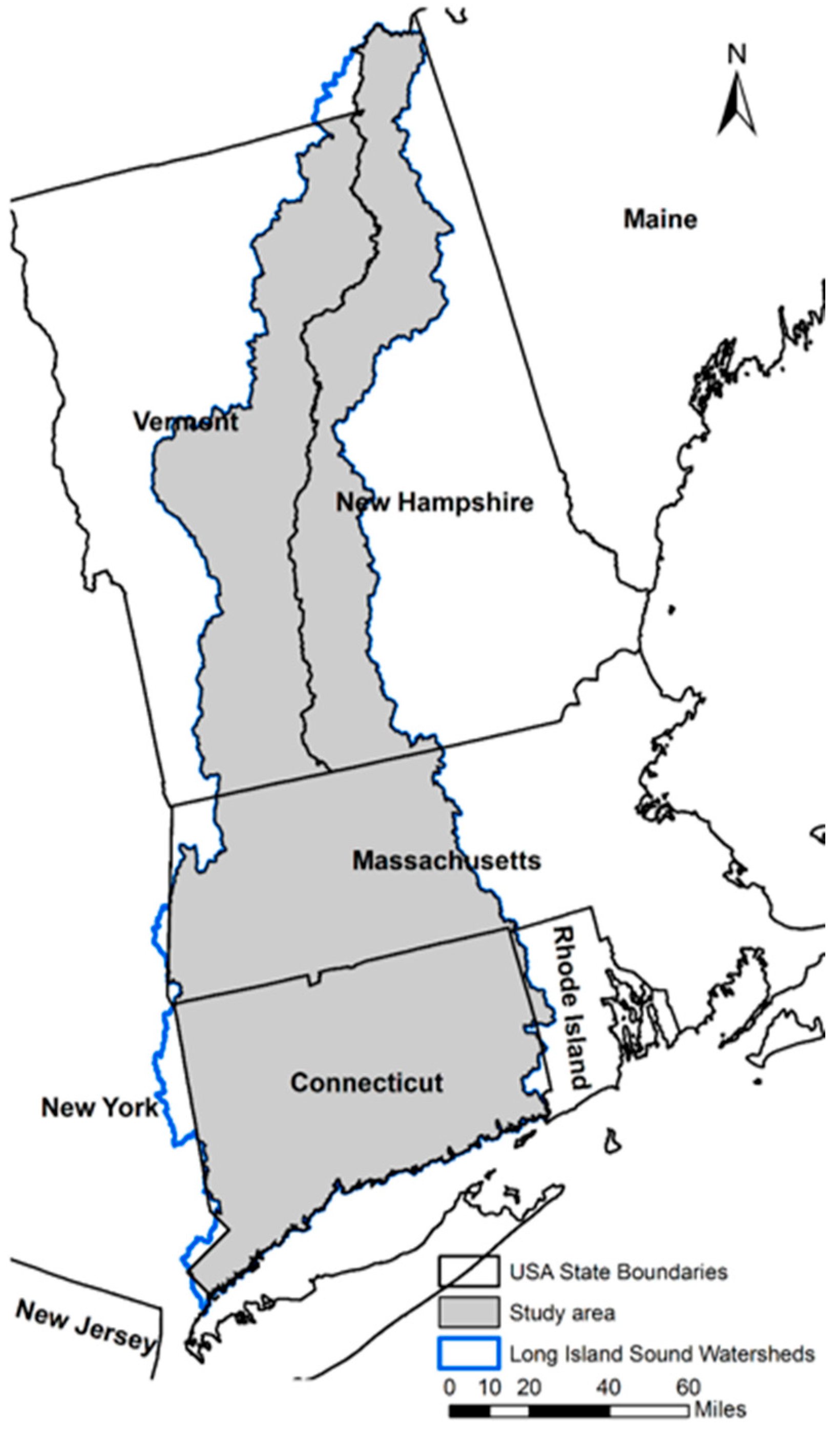
2.1. Study Area
2.2. Data
2.3. LUCC Prediction
2.3.1. LR–MC Model
2.3.2. MLP–MC Model
3. Results and Analyses
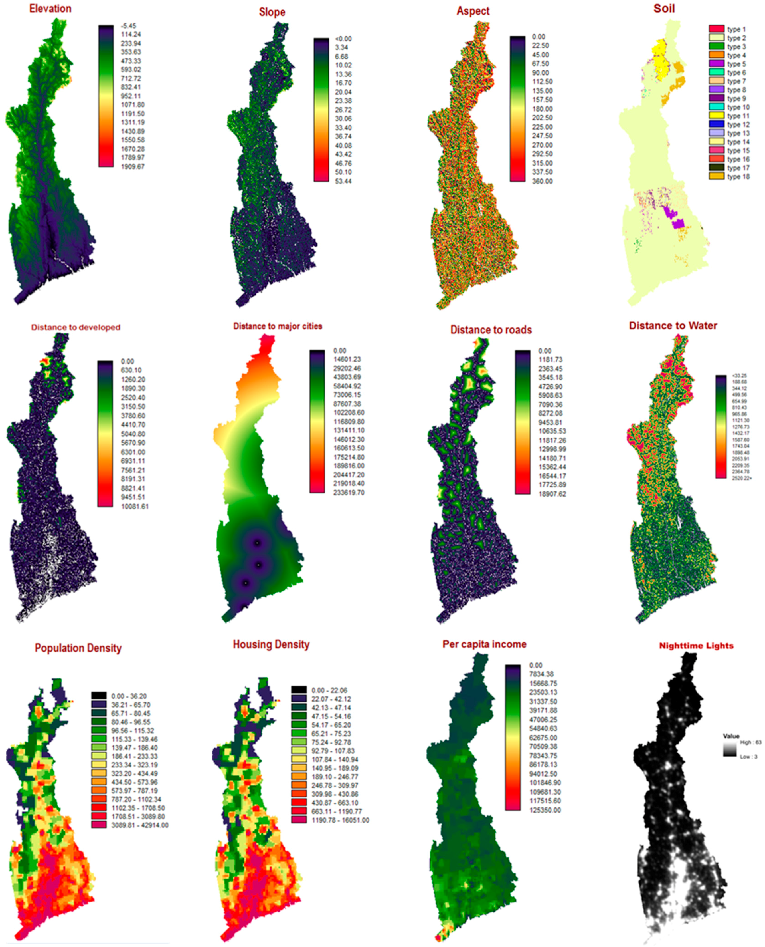
3.1. LUCC Driving Forces
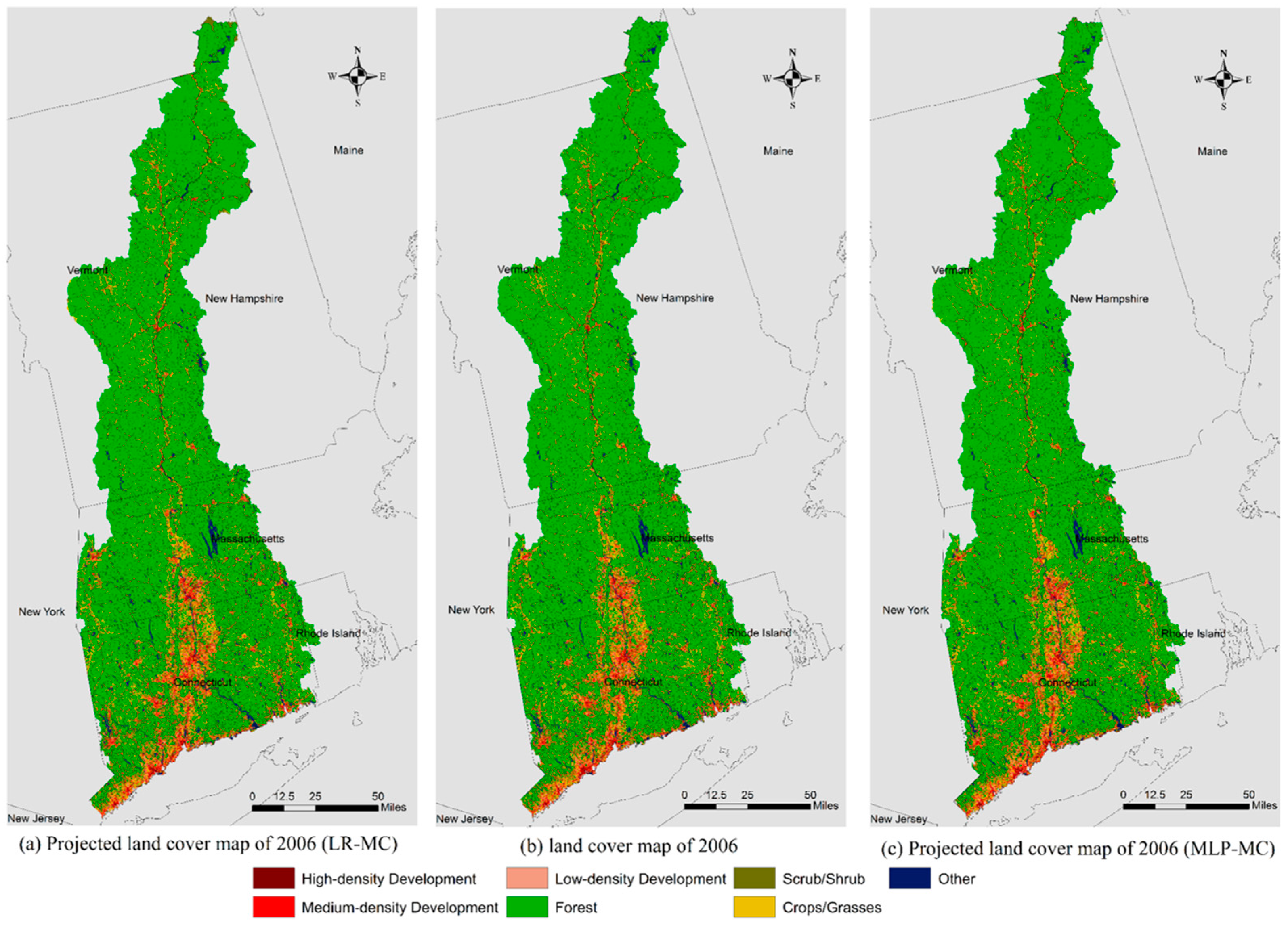
3.2. Model Comparison and Validation
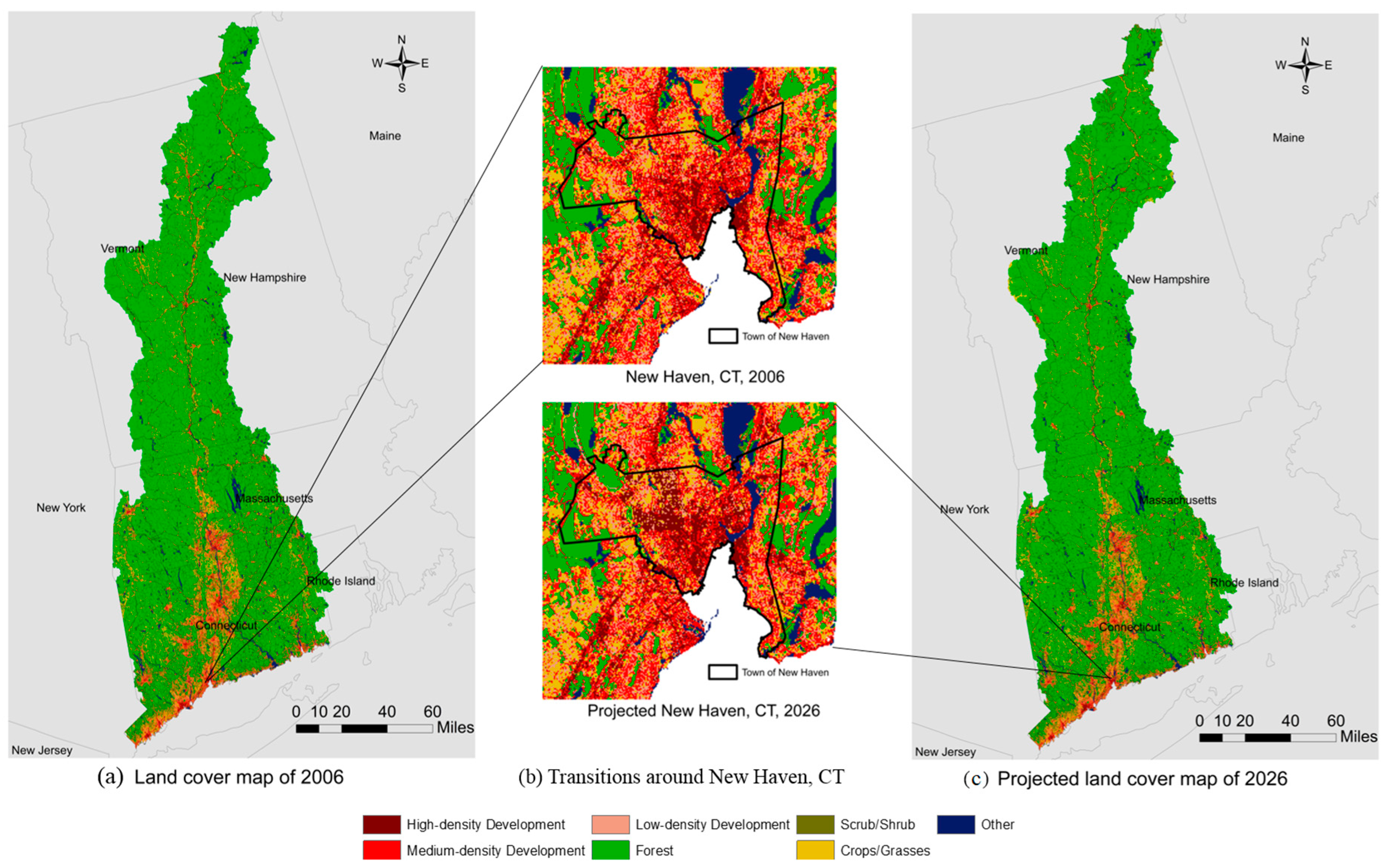
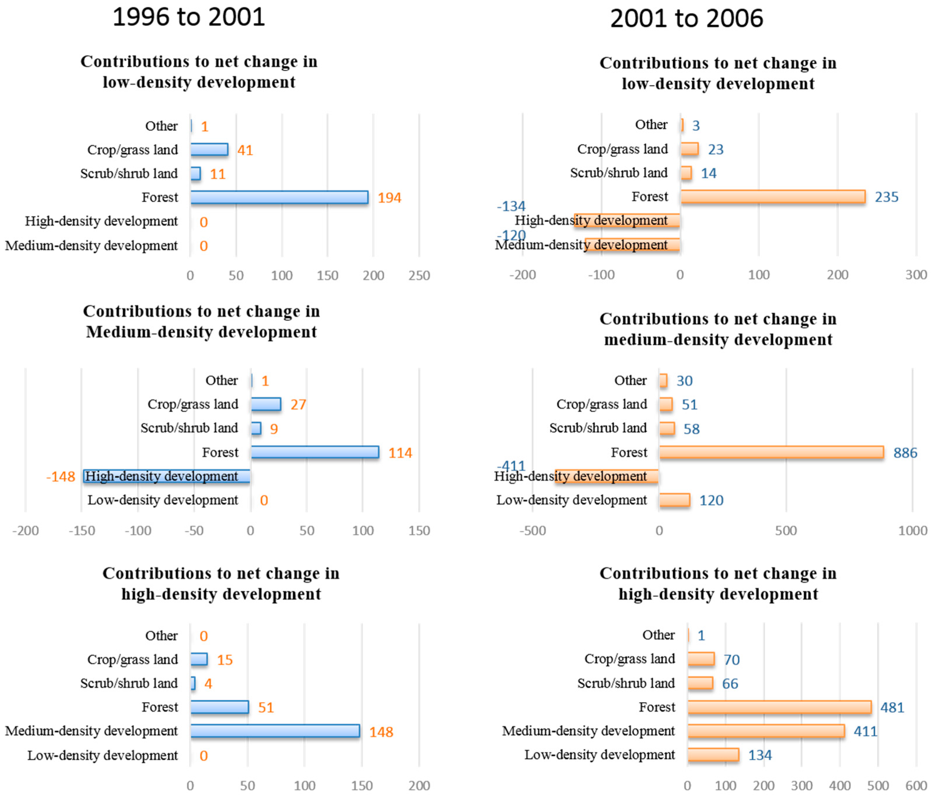
3.3. LUCC Analysis
4. Discussion
5. Conclusions
Acknowledgments
Author Contributions
Conflicts of Interest
References
- Hopkinson, C.S.; Vallino, J.J. The relationships among man’s activities in watersheds and estuaries: A model of runoff effects on patterns of estuarine community metabolism. Estuaries 1995, 18, 598–621. [Google Scholar] [CrossRef]
- Long Island Sound Study. Protection & Progress, Long Island Sound Study Biennial Report 2011–2012; R.C. Brayshaw and Company: Warner, NH, USA, 2013. [Google Scholar]
- Long Island Sound Study. Long Island Sound Study CCMP; Environmental Protection Agency: Washington, DC, USA, 1994.
- 2003 Long Island Sound Agreement. Available online: http://longislandsoundstudy.net/about/our-mission/sound-agreements/2003-long-island-sound-agreement/ (accessed on 28 September 2016).
- Bhaduri, B.; Harbor, J.; Engel, B.; Grove, M. Assessing watershed-scale, long-term hydrologic impacts of land-use change using a GIS-NPS model. Environ. Manag. 2000, 26, 643–658. [Google Scholar] [CrossRef] [PubMed]
- Tong, S.T.; Chen, W. Modeling the relationship between land use and surface water quality. J. Environ. Manag. 2002, 66, 377–393. [Google Scholar] [CrossRef]
- Meador, M.R.; Goldstein, R.M. Assessing water quality at large geographic scales: Relations among land use, water physicochemistry, riparian condition, and fish community structure. Environ. Manag. 2003, 31, 0504–0517. [Google Scholar] [CrossRef] [PubMed]
- Meyer, J.L.; Sale, M.J.; Mulholland, P.J.; Poff, N.L. Impacts of climate change on aquatic ecosystem functioning and health1. J. Am. Water Resour. Assoc. 1999. [Google Scholar] [CrossRef]
- Strayer, D.L.; Beighley, R.E.; Thompson, L.C.; Brooks, S.; Nilsson, C.; Pinay, G.; Naiman, R.J. Effects of land cover on stream ecosystems: Roles of empirical models and scaling issues. Ecosystems 2003, 6, 407–423. [Google Scholar] [CrossRef]
- Akber, M.A.; Shrestha, R.P. Land use change and its effect on biodiversity in Chiang Rai province of Thailand. J. Land Use Sci. 2015, 10, 108–128. [Google Scholar] [CrossRef]
- Scott, M.C.; Helfman, G.S. Native invasions, homogenization, and the mismeasure of integrity of fish assemblages. Fisheries 2001, 26, 6–15. [Google Scholar] [CrossRef]
- Quinn, J.M.; Cooper, A.B.; Davies-Colley, R.J.; Rutherford, J.C.; Williamson, R.B. Land use effects on habitat, water quality, periphyton, and benthic invertebrates in Waikato, New Zealand, hill-country streams. N. Z. J. Mar. Freshw. Res. 1997, 31, 579–597. [Google Scholar] [CrossRef]
- Foster, D.R. Land-use history (1730–1990) and vegetation dynamics in central New England, USA. J. Ecol. 1992. [Google Scholar] [CrossRef]
- Foster, D.R.; Aber, J. Forests in Time. Ecosystem Structure and Function as a Consequence of 1000 Years of Change. Synthesis volume of the Harvard Forest LTER Program; Yale University Press: New Haven, CT, USA, 2004. [Google Scholar]
- Houghton, R.; Hackler, J. Changes in terrestrial carbon storage in the United States. 1: The roles of agriculture and forestry. Glob. Ecol. Biogeogr. 2000, 9, 125–144. [Google Scholar] [CrossRef]
- Heimlich, R.E.; Anderson, W.D. Development at the Urban Fringe and Beyond: Impacts on Agriculture and Rural. Economic Research Service; US Department of Agriculture: Washington, DC, USA, 2001.
- Hall, B.; Motzkin, G.; Foster, D.R.; Syfert, M.; Burk, J. Three hundred years of forest and land-use change in Massachusetts, USA. J. Biogeogr. 2002, 29, 1319–1335. [Google Scholar] [CrossRef]
- Brown, D.G.; Johnson, K.M.; Loveland, T.R.; Theobald, D.M. Rural land-use trends in the conterminous United States, 1950–2000. Ecol. Appl. 2005, 15, 1851–1863. [Google Scholar] [CrossRef]
- Mosher, E.S.; Silander, J.A., Jr.; Latimer, A.M. The role of land-use history in major invasions by woody plant species in the northeastern North American landscape. Biol. Invasions 2009, 11, 2317–2328. [Google Scholar] [CrossRef]
- Foster, D.; Aber, J.; Cogbill, C.; Hart, C.; Colburn, E.; D'Amato, A.; Donahue, B.; Driscoll, C.; Ellison, A.; Fahey, T.; et al. Wildlands and Woodlands: A vision for the New England Landscape; Harvard University Press: Cambridge, MA, USA, 2010. [Google Scholar]
- Jeon, S.B.; Olofsson, P.; Woodcock, C.E. Land use change in New England: A reversal of the forest transition. J. Land Use Sci. 2014, 9, 105–130. [Google Scholar] [CrossRef]
- Drummond, M.A.; Loveland, T.R. Land-use pressure and a transition to forest-cover loss in the Eastern United States. BioScience 2010, 60, 286–298. [Google Scholar] [CrossRef]
- Brown, D.G.; Duh, J.D. Spatial simulation for translating from land use to land cover. Int. J. Geogr. Infor. Sci. 2004, 18, 35–60. [Google Scholar] [CrossRef]
- Brown, D.G.; Aspinall, R.; Bennett, D.A. Landscape models and explanation in landscape ecology—A space for generative landscape science? Prof. Geogr. 2006, 58, 369–382. [Google Scholar] [CrossRef]
- Veldkamp, A.; Lambin, E.F. Predicting land-use change. Agric. Ecosyst. Environ. 2001, 85, 1–6. [Google Scholar] [CrossRef]
- Overmars, K.; de Koning, G.; Veldkamp, A. Spatial autocorrelation in multi-scale land use models. Ecol. Model. 2003, 164, 257–270. [Google Scholar] [CrossRef]
- Brown, D.G.; Verburg, P.H.; Pontius, R.G.; Lange, M.D. Opportunities to improve impact, integration, and evaluation of land change models. Curr. Opin. Environ. Sustain. 2013, 5, 452–457. [Google Scholar] [CrossRef]
- Rosa, I.; Ahmed, S.E.; Ewers, R.M. The transparency, reliability and utility of tropical rainforest land-use and land-cover change models. Glob. Chang. Biol. 2014, 20, 1707–1722. [Google Scholar] [CrossRef] [PubMed]
- Eastman, J.R. IDRISI Selva; Clark University: Worcester, MA, USA, 2012. [Google Scholar]
- Pueyo, Y.; Beguería, S. Modelling the rate of secondary succession after farmland abandonment in a Mediterranean Mountain Area. Landsc. Urban Plan. 2007, 83, 245–254. [Google Scholar] [CrossRef]
- Oñate-Valdivieso, F.; Sendra, J.B. Application of GIS and remote sensing techniques in generation of land use scenarios for hydrological modeling. J. Hydrol. 2010, 395, 256–263. [Google Scholar] [CrossRef]
- Pérez-Vega, A.; Mas, J.F.; Ligmann-Zielinska, A. Comparing two approaches to land use/cover change modeling and their implications for the assessment of biodiversity loss in a deciduous tropical forest. Environ. Model. Softw. 2012, 29, 11–23. [Google Scholar] [CrossRef]
- Arsanjani, J.J.; Helbich, M.; Kainz, W.; Boloorani, A.D. Integration of logistic regression, Markov chain and cellular automata models to simulate urban expansion. Int. J. Appl. Earth Obs. Geoinf. 2013, 21, 265–275. [Google Scholar] [CrossRef]
- Wang, W.; Zhang, C.; Allen, J.M.; Li, W.; Boyer, M.A.; Segerson, K.; Silander, J.A. Analysis and prediction of land use changes related to invasive species and major driving forces in the state of Connecticut. Land 2016. [Google Scholar] [CrossRef]
- Poelmans, L.; Van Rompaey, A. Complexity and performance of urban expansion models. Comput. Environ. Urban Syst. 2010, 34, 17–27. [Google Scholar] [CrossRef]
- Dubovyk, O.; Sliuzas, R.; Flacke, J. Spatio-temporal modelling of informal settlement development in Sancaktepe district, Istanbul, Turkey. ISPRS J. Photogramm. Remote Sens. 2011, 66, 235–246. [Google Scholar] [CrossRef]
- Musaoglu, N.; Tanik, A.; Kocabas, V. Identification of land-cover changes through image processing and associated impacts on water reservoir conditions. Environ. Manag. 2005, 35, 220–230. [Google Scholar] [CrossRef] [PubMed]
- Hu, Z.; Lo, C. Modeling urban growth in Atlanta using logistic regression. Comput. Environ. Urban Syst. 2007, 31, 667–688. [Google Scholar] [CrossRef]
- Elvidge, C.D.; Baugh, K.E.; Zhizhin, M.; Hsu, F.C. Why VIIRS data are superior to DMSP for mapping nighttime lights. Proc. Asia-Pacific Adv. Netw. 2013, 35, 62–69. [Google Scholar] [CrossRef]
- Elvidge, C.D.; Ziskin, D.; Baugh, K.E.; Tuttle, B.T.; Ghosh, T.; Pack, D.W.; Erwin, E.H.; Zhizhin, M. A fifteen year record of global natural gas flaring derived from satellite data. Energies 2009, 2, 595–622. [Google Scholar] [CrossRef]
- Zhang, Q.; Seto, K.C. Mapping urbanization dynamics at regional and global scales using multi-temporal DMSP/OLS nighttime light data. Remote Sens. Environ. 2011, 15, 2320–2329. [Google Scholar] [CrossRef]
- Ghosh, T.; Powell, R.L.; Elvidge, C.D.; Baugh, K.E.; Sutton, P.C.; Anderson, S. Shedding light on the global distribution of economic activity. Open Geogr. J. 2010. [Google Scholar] [CrossRef]
- Henderson, J.V.; Storeygard, A.; Weil, D.N. Measuring economic growth from outer space. Am. Econ. Rev. 2012, 102, 994–1028. [Google Scholar] [CrossRef] [PubMed]
- Hsu, F.C.; Elvidge, C.D.; Matsuno, Y. Exploring and estimating in-use steel stocks in civil engineering and buildings from night-time lights. Int. J. Remote Sens. 2013, 34, 490–504. [Google Scholar]
- Keola, S.; Andersson, M.; Hall, O. Monitoring economic development from space: using nighttime light and land cover data to measure economic growth. World Dev. 2015, 66, 322–334. [Google Scholar]
- Cronon, W. Changes in the Land: Indians, Colonists, and the Ecology of New England; Hill & Wang: New York, NY, USA, 2011. [Google Scholar]
- Turner, B.L., II; Skole, D.; Sanderson, S.; Fischer, G.; Fresco, L.; Leemans, R. Land-Use and Land-Cover Change, Science/Research Plan; IIASA: Laxenburg, Austria, 1995. [Google Scholar]
- Rodríguez Eraso, N.; Armenteras-Pascual, D.; Alumbreros, J.R. Land use and land cover change in the Colombian Andes: Dynamics and future scenarios. J. Land Use Sci. 2013, 8, 154–174. [Google Scholar] [CrossRef]
- Mellander, C.; Lobo, J.; Stolarick, K.; Matheson, Z. Night-time light data: A good proxy measure for economic activity? PloS ONE 2015. [Google Scholar] [CrossRef] [PubMed]
- Munroe, D.K.; Southworth, J.; Tucker, C.M. Modeling spatially and temporally complex land-cover change: the case of western Honduras *. Prof. Geogr. 2004, 56, 544–559. [Google Scholar]
- Mas, J.F.; Puig, H.; Palacio, J.L.; Sosa-López, A. Modelling deforestation using GIS and artificial neural networks. Environ. Model. Softw. 2004, 19, 461–471. [Google Scholar] [CrossRef]
- Eastman, J.R. IDRISI Taiga Guide to GIS and Image Processing; Clark Labs, Clark University: Worcester, MA, USA, 2009. [Google Scholar]
- Liebetrau, A.M. Measures of Association; Sage: Newbury Park, CA, USA, 1983. [Google Scholar]
- Eastman, J.R. IDRISI Andes Guide to GIS and Image Processing; Clark University: Worcester, MA, USA, 2006; pp. 87–131. [Google Scholar]
- Heimlich, R.E.; Anderson, W.D. Development at the Urban Fringe and Beyond: Impacts on Agriculture and Rural; US Department of Agriculture: Washington, DC, USA, 2001.
- Alig, R.; Mills, J.; Butler, B. Private timberlands: Growing demands, shrinking land base. J. For. 2002, 100, 32–37. [Google Scholar]
- Mas, J.F.; Kolb, M.; Paegelow, M.; Olmedo, M.T.C.; Houet, T. Inductive pattern-based land use/cover change models: A comparison of four software packages. Environ. Model. Softw. 2014, 51, 94–111. [Google Scholar] [CrossRef]
- The Nature Conservancy. A Policy Agenda for Conserving New England's Forests. 2013. Available online: http://www.nature.org/ourinitiatives/regions/northamerica/unitedstates/massachusetts/newsroom/policy-agenda-ne-forests-13.pdf (accessed on 1 October 2016).


| Processed Data | Data Sources | |
|---|---|---|
| Biophysical drivers | Elevation | USGS National Elevation Dataset (NED) |
| Slope | Calculated from USGS Elevation data | |
| Aspect | Calculated from USGS Elevation data | |
| Soil type | National Historical Geographic Information System (NHGIS) | |
| Socio-economic drivers | Nighttime light intensity | National Centers for Environmental Information (NCEI) |
| Per capita income (gridded) | National Historical Geographic Information System (NHGIS) | |
| Population density (gridded) | National Historical Geographic Information System (NHGIS) | |
| Housing density (gridded) | National Historical Geographic Information System (NHGIS) | |
| Proximity causes | Roads (primary and secondary) | US Census Bureau TIGER files |
| Distance to road | US Census Bureau TIGER files | |
| Distance to water | U.S. Geological Survey (USGS) | |
| Distance to major city | U.S. Geological Survey (USGS) | |
| Distance to developed area | U.S. Geological Survey (USGS) |
| Low-Density Development | Medium-Densiy Development | High-Density Development | Forest | Crop/Grass | Scrub/Shrub | Other | Overall | |
|---|---|---|---|---|---|---|---|---|
| Elevation | 0.2072 | 0.2171 | 0.1778 | 0.3990 | 0.1964 | 0.0276 | 0.1552 | 0.1900 |
| Slope | 0.1112 | 0.1305 | 0.0952 | 0.3582 | 0.1739 | 0.0387 | 0.3567 | 0.1923 |
| Aspect | 0.0168 | 0.0260 | 0.0134 | 0.1161 | 0.0556 | 0.0115 | 0.3410 | 0.1414 |
| Soil type | 0.0447 | 0.0634 | 0.0249 | 0.1237 | 0.0847 | 0.0239 | 0.0655 | 0.0579 |
| NTL | 0.2844 | 0.2682 | 0.2459 | 0.4254 | 0.1917 | 0.0316 | 0.0779 | 0.2207 |
| Per capita income | 0.0758 | 0.0924 | 0.0583 | 0.1519 | 0.0925 | 0.0351 | 0.0536 | 0.0756 |
| Housing density | 0.2788 | 0.2484 | 0.2716 | 0.3824 | 0.1443 | 0.0215 | 0.0565 | 0.2108 |
| Population density | 0.2794 | 0.2464 | 0.2620 | 0.3765 | 0.1374 | 0.0231 | 0.0476 | 0.2071 |
| Distance to city | 0.1175 | 0.1406 | 0.0957 | 0.2290 | 0.1265 | 0.0160 | 0.0322 | 0.1080 |
| Distance to developed area | 0.1875 | 0.3969 | 0.1955 | 0.4806 | 0.2240 | 0.0238 | 0.0451 | 0.2903 |
| Distance to road | 0.2056 | 0.3851 | 0.0908 | 0.4331 | 0.2066 | 0.0263 | 0.0557 | 0.2148 |
| Distance to water | 0.0658 | 0.1015 | 0.0364 | 0.2681 | 0.0861 | 0.0090 | 0.55476 | 0.2373 |
| Class | 1996 | 2001 | 2006 | 1996–2001 | 2001–2006 | |||
|---|---|---|---|---|---|---|---|---|
| ha | % | ha | % | ha | % | |||
| Low-density development | 85,229 | 2.13% | 85,476 | 2.14% | 85,497 | 2.14% | 247 | 22 |
| Medium-density development | 308,424 | 7.72% | 308,426 | 7.72% | 309,159 | 7.74% | 3 | 733 |
| High-density development | 22,734 | 0.57% | 22,953 | 0.57% | 24,118 | 0.60% | 219 | 1165 |
| Forest | 2,974,558 | 74.43% | 2,966,988 | 74.24% | 2,954,157 | 73.92% | −7569 | −12,831 |
| Scrub/shrub land | 71,335 | 1.79% | 76,536 | 1.92% | 81,241 | 2.03% | 5201 | 4705 |
| Crop/grass land | 403,105 | 10.09% | 404,577 | 10.12% | 410,134 | 10.26% | 1471 | 5557 |
| Other | 130,906 | 3.28% | 131,335 | 3.29% | 131,985 | 3.30% | 429 | 649 |
| Class | Projected 2026 Data | Change from 2006 to 2026 (ha) | |
|---|---|---|---|
| ha | % | ||
| Low-density development | 86,929 | 2.18% | 1432 |
| Medium-density development | 308,783 | 7.73% | −377 |
| High-density development | 29,562 | 0.74% | 5444 |
| Forest | 2,903,735 | 72.66% | −50,422 |
| Scrub/shrub | 99,232 | 2.48% | 17,991 |
| Crop/grass | 432,899 | 10.83% | 22,765 |
| Other | 135,152 | 3.38% | 3167 |
© 2016 by the authors; licensee MDPI, Basel, Switzerland. This article is an open access article distributed under the terms and conditions of the Creative Commons Attribution (CC-BY) license (http://creativecommons.org/licenses/by/4.0/).
Share and Cite
Zhai, R.; Zhang, C.; Li, W.; Boyer, M.A.; Hanink, D. Prediction of Land Use Change in Long Island Sound Watersheds Using Nighttime Light Data. Land 2016, 5, 44. https://doi.org/10.3390/land5040044
Zhai R, Zhang C, Li W, Boyer MA, Hanink D. Prediction of Land Use Change in Long Island Sound Watersheds Using Nighttime Light Data. Land. 2016; 5(4):44. https://doi.org/10.3390/land5040044
Chicago/Turabian StyleZhai, Ruiting, Chuanrong Zhang, Weidong Li, Mark A. Boyer, and Dean Hanink. 2016. "Prediction of Land Use Change in Long Island Sound Watersheds Using Nighttime Light Data" Land 5, no. 4: 44. https://doi.org/10.3390/land5040044
APA StyleZhai, R., Zhang, C., Li, W., Boyer, M. A., & Hanink, D. (2016). Prediction of Land Use Change in Long Island Sound Watersheds Using Nighttime Light Data. Land, 5(4), 44. https://doi.org/10.3390/land5040044