Abstract
Urban livability and sustainable development remain major global challenges, yet the interplay between urban planning layouts and actual human activities has not been sufficiently examined. This study investigates this relationship in Beijing by integrating multi-source spatiotemporal data, including point of interest (POI), Land Use Cover Change (LUCC), remote sensing data, and the railway network. Defining urban functional units as “street + railway network”, we analyze the spatial–temporal evolution within the 6th Ring Road over the past four decades and propose targeted strategies for the urban functional layout. The results reveal the following: (1) The evolution of Beijing’s urban functions can be divided into four stages (1980–1990, 1990–2005, 2005–2015, and 2015–2020), with continuous population growth (+142%) driving the over-concentration of functions in central districts. (2) Between 2010 and 2020, the POI densities of medical services (+133.6%) and transport services (+130.48%) increased most rapidly, subsequently stimulating the expansion of other urban functions. (3) High-density functional facilities and construction land (+179.10%) have expanded significantly within the 6th Ring Road, while green space (cropland, forestland and grassland) has decreased by 86.97%, resulting in a severe imbalance among land use types. To address these issues, we recommend the following: redistributing high-intensity functions to sub-centers such as Tongzhou and Xiongan New Area to alleviate population pressure, expanding high-capacity rail transit to reinforce 30–50 km commuting links between the core and periphery, and establishing ecological corridors to connect green wedges, thereby enhancing carbon sequestration and environmental quality. This integrated framework offers transferable insights for other megacities, providing guidance for sustainable functional planning that aligns human activity patterns with urban spatial structures.
1. Introduction
Global urbanization is one of the most transformative trends of the 21st century [1,2]. By 2018, 55% of the world’s population lived in cities, and this share is projected to rise to 68% by 2050 [3]. Yet, the planning of urban functional areas often lags behind rapid urban expansion [4]. Consequently, many megacities suffer from congestion, soaring housing prices, limited green spaces, biodiversity loss, and the urban heat island effect [5]. Classical theories such as Burgess’s [6] concentric zone model, Hoyt’s [7] sector model, and Harris and Ullman’s [8] multiple nuclei model laid the foundation for understanding the evolution of urban spatial functions, particularly in developed countries [9]. Similarly, early concepts including Howard’s [10] Garden City, Perry’s [11] Neighborhood Unit, and Reichow’s [12] Organische Stadtbaukunst emphasized functional zoning but also revealed the limitations of static approaches. In China, however, urban functional research is relatively recent and has primarily focused on large cities like Beijing and Shanghai, leading to theories such as multicore development [13] and the urban new-edge theory [14]. Due to contextual differences between China and the West, many advanced models cannot be directly applied, underscoring the need for locally adapted approaches.
Traditional studies of urban function often rely on administrative boundaries (district or county) [15] or single-source data (e.g., population, night lights, or land use) [16]. These methods tend to overlook human–land interactions and the dynamic nature of functional evolution, while also being constrained by statistical data with long time lags [17]. Consequently, long-term and fine-scale analyses remain limited. With the rapid development of big data and multi-source spatiotemporal datasets [18,19], it has become possible to capture urban functional changes at both refined spatial and temporal scales. Commonly used datasets include point of interest (POI), Land Use/Cover Change (LUCC), and remote sensing images. For instance, Yi, Yang [20] demonstrated the feasibility of POI in identifying urban functions, while Pisano [21] and Frago [22] applied multi-source data to analyze functional layouts in European cities during COVID-19. Yet, each dataset has inherent biases: POI underrepresents natural landscapes, while LUCC better captures ecological features. This study integrates POI and LUCC to leverage their complementary strengths, combined with a hierarchical classification system to refine functional delineation, thereby improving accuracy and applicability for rapidly urbanizing regions.
Scholars have also explored urban functional evolution from different perspectives. Lynch’s [23] The Image of the City and Venturi’s [24] Complexity and Contradiction in Architecture highlighted spatial perception and multifunctional design, concepts that inform this study’s classification framework. However, most research still centers on developed countries such as the United States and the United Kingdom [25], with far less attention given to developing countries [26]. As the largest developing country, China has experienced unprecedented urbanization. Beijing, as its capital and a multifunctional megacity, represents a critical case for studying urban functional evolution [27]. Existing Beijing-focused studies, however, usually address single issues—such as agricultural land layout [28] or the urban heat island effect [29]—and rarely provide an integrated long-term analysis of functional evolution [30,31].
Against this background, this study seeks to overcome these gaps by integrating multi-source spatiotemporal data into a refined analytical framework. The objectives are as follows: (1) to develop an approach that jointly considers human activities and the physical urban structure, using the “street + railway network” as the basic functional unit; (2) to couple LUCC, POI, remote sensing, and railway networks over four decades (1980–2020) for long-term, fine-scale analysis of functional evolution; (3) to examine the spatiotemporal dynamics of key functions (e.g., educational, residential, and transport services) in Beijing; and (4) to identify challenges and propose evidence-based strategies for functional zoning in the megacities of developing countries. The methodological innovations lie in the integration of multi-source datasets at high spatial–temporal resolutions, the application of a hierarchical LUCC–POI classification to enhance functional delineation, and the provision of transferable insights for sustainable urban planning in rapidly urbanizing contexts.
2. Materials and Methods
2.1. Study Area
Beijing, the capital of China, is located at 115°24′ E–117°30′ E, 39°26′ N–41°3′ N. As the political and cultural center of China, Beijing is one of the world’s typical megacities with complex urban functions [32]. According to the data of the seventh national census of China, the permanent population of Beijing is 21.53 million (accounting for 1.55% of the population of China), and the urban area is 16,410.54 km2 (accounting for 0.17% of the area of China). As the main urban construction area, the 6th Ring Road in Beijing concentrates most of the residential areas in Beijing and is also the most concentrated area of urban functions. Therefore, this study selects the area within the 6th Ring Road of Beijing, with Tiananmen Square as the center and the 6th Ring Road as the boundary, covering a total area of 2317 km2 (Figure 1).
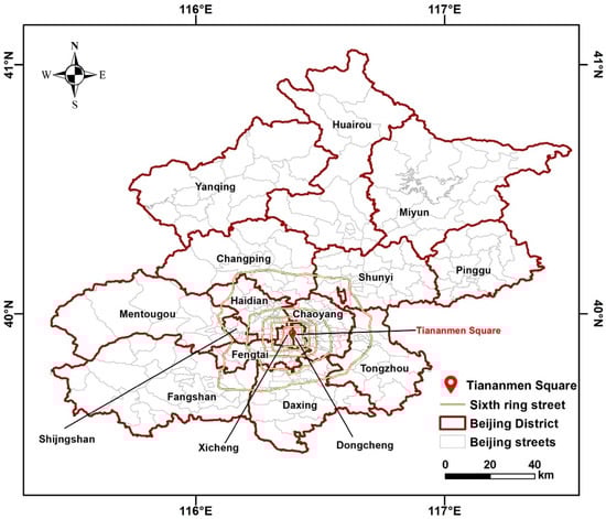
Figure 1.
Map of study area.
2.2. Methodological Framework
The theoretical framework of this study is shown in Figure 2, which mainly includes four processes: (a) Data preparation: ArcGIS 10.6 and Envi 5.6 software were used to preprocess the data used in this study, including (1) unifying the spatial resolution of raster data and remote sensing images to 30 m, (2) removing duplicated POI records, (3) converting original coordinates to “WGS_1984_UTM_Zone_50N”. (b) Functional unit division: We divide the functional units by combining the street units and the railway network, with the help of old maps and statistical yearbooks of Beijing. (c) “LUCC+POI+n” multi-source data fusion: Combining POI, LUCC, and other data to jointly identify the dominant functions of functional units. For specific rules, see Section 2.4. (d) Spatial analysis and validation: The spatiotemporal evolution of urban functions includes kernel density analysis, hotspot analysis, and evolution analysis of the overall layout of urban functions. And the results of spatial analysis are examined based on remote sensing data (from Landsat 4-5 TM and Landsat 8 OLI_TIRS).
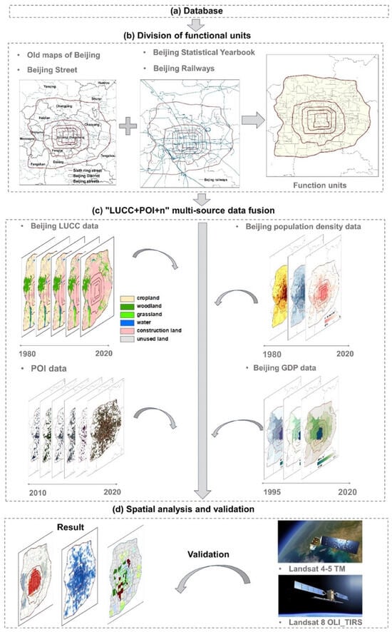
Figure 2.
Theoretical framework of this study.
2.3. Data
2.3.1. Remote Sensing Data
- (1)
- Land use cover change (LUCC) data
The LUCC data used in this study were obtained from the China Multi-Period Land Use Remote Sensing Monitoring Dataset (CNLUCC) of the Resource and Environment Science and Data Center of the Chinese Academy of Sciences (RESDC) [33], with a spatial resolution of 30 m. This study reclassifies land use types into six categories: cropland, woodland, grassland, water, construction land, and unused land. The distribution of land use types (Figure 3) in Beijing over the past forty years (1980–2020) is shown below.
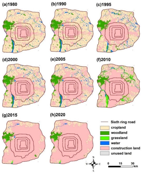
Figure 3.
Distribution map of LUCC in Beijing from 1980 to 2020.
- (2)
- Other remote sensing images
Landsat 4-5 TM and Landsat 8 OLI_TIRS digital products (1980–2013, 2013–2020, spatial resolution of 30 m) were selected from the geospatial data cloud as the urban functional area identification testing data.
2.3.2. POI Data
Point of interest (POI) data are point data of high-precision geographic entities, which are widely used by scholars because of their wide coverage, easy access, and fast update [34]. It often describes and characterizes urban functions and residents’ travel frequency [35]. This study collected POI data of Beijing for the past 10 years (2010, 2015, and 2020) from the shared interface of the development platform of Gaode, with a total of 128,000 records. There are more than 50 original types per year. The POI data were reclassified regarding the Urban Land Use Classification and Planning Construction Land Use Standard (GB50137-2011) [36] and the Classification of Land Use Status Quo (GB/T21010-2017) [37]. The classification results include six primary functions and sixteen secondary urban functional areas. The specific classification rules are shown in Table 1.

Table 1.
Classification rules for functional unit and POI data.
2.3.3. Other Datasets
(1) Basic geographic data: The basic geographic data such as the Beijing administrative division map (.shp) and the old map of Beijing (.jpg) were obtained from RESDC.
(2) Urban road network data: This study selects the urban road network data from OpenStreetMap (OSM), which contains the distribution of traffic roads and traffic accessory facilities at all levels in Beijing. The irregular grid formed by highways and first-, second-, and third-level roads is used as a reference for the division of functional units.
(3) Socioeconomic data: The socioeconomic data used in this study include the Beijing Statistical Yearbook (1949–2020) [38], population, and Gross Domestic Product (GDP). The population data are from the WorldPop global population dataset. This dataset has a spatial and temporal resolution of 1 km and 1 year, respectively; the spatial distribution of China’s GDP in kilometer grid dataset is from RESDC, and the temporal resolution is 1 year.
2.3.4. Data Preprocessing and Temporal Harmonization
All datasets were spatially aligned to WGS_1984_UTM_Zone_50N. Raster data were resampled to a 30 m resolution. Temporal harmonization was achieved by selecting overlapping years across datasets and interpolating missing years where necessary, ensuring consistency across POI (2010–2020), LUCC (1980–2020), and socioeconomic datasets (1980–2020).
Temporal inconsistencies among POI (2010–2020), LUCC (1980–2020), and socioeconomic data were addressed by matching overlapping years, interpolating gaps, and validating against census records to minimize analytical distortion.
Detailed specifications of all datasets are provided in Table 2.
Table 2.
Data description and sources.
2.4. Definition and Division of Urban Functional Units
2.4.1. Definition and Division of Functional Units (UFAs)
Urban functional units (UFAs) are homogeneous spatial entities characterized by specific urban functions [39]. In this study, UFAs within Beijing’s 6th Ring Road were delineated by overlaying the 2020 street and railway networks with major geographical features (e.g., rivers, hills, iconic buildings), resulting in 500 functional parcels (Figure 2b).
The choice of 500 parcels was not arbitrary but derived from the inherent subdivision of the street network and urban design features. This level of granularity provides sufficient spatial detail to capture intra-urban functional heterogeneity, while maintaining computational feasibility and interpretability. To assess the robustness of this choice, we conducted a sensitivity check by testing alternative partitioning schemes (around ±20% parcel numbers, i.e., ~400 and ~600 units). The results showed only minor changes in the overall distribution of functional categories (<5% variation), indicating that the classification outcomes are not overly sensitive to unit size. Historical maps (1980s) and Beijing Statistical Yearbooks (1980–2023) were also consulted to confirm the scientific validity and temporal continuity of the division.
2.4.2. POI Density Method for Function Classification
The dominant function of each UFA was first determined using the POI density method [40]. POI data capture various functions (e.g., residential, commercial, educational, healthcare). The density of function j in unit i is defined as (Equation (1))
where is the density of POI type j in unit i, is the number of POIs of type j in unit i, and is the total number of POIs in units. The function with the highest density is assigned as the dominant function.
2.4.3. Multi-Source Data Fusion (POI+LUCC+Socioeconomic Indicators)
To improve classification accuracy, we employed a “POI+LUCC+N” fusion method, where N denotes socioeconomic indicators (population density and GDP). Specifically, POI data capture the fine-grained functional characteristics of urban spaces; LUCC datasets provide land use context and help resolve cases where POI densities are similar across categories; socioeconomic indicators are incorporated to refine classification when ambiguity persists. The decision rules are summarized in Table 1 and illustrated in Figure 2c. This multi-source approach ensures that the final classification reflects both spatial structure and socioeconomic reality.
A methodological challenge arises from the temporal limitation of POI datasets, which are only available with sufficient completeness and consistency after 2010. To extend the analysis to 1980–2010, functional categories were inferred retrospectively by triangulating multiple historical sources: (i) historical maps (1980s–2000s) provided the spatial distribution of major land uses such as residential, industrial, and green spaces; (ii) Beijing Statistical Yearbooks (1980–2010) supplied sectoral data (e.g., population, employment, education, healthcare, GDP) to indicate the relative importance of different urban functions; and (iii) LUCC datasets with long temporal coverage captured land cover transitions (e.g., farmland conversion to residential or commercial land). POI data from 2010 were used as a baseline, and earlier functional assignments were systematically adjusted according to documented demographic, economic, and land use changes.
This multi-source triangulation ensured that pre-2010 functional classifications are historically grounded and consistent with observed urban development trajectories, rather than being a direct extrapolation from modern POI distributions.
2.4.4. Validation of Functional Unit Classification
The results were validated against multiple references: (i) the Beijing Urban Master Plan (2004–2020), (ii) Google Maps and remote sensing imagery, and (iii) comparisons with known residential, commercial, and educational zones. This cross-validation confirms that the identified UFAs align with real-world land use and functional patterns. Details are further discussed in Section 4.1.
2.5. Hotspot Analysis
To identify the spatial clustering characteristics of different urban functions, we employed the Getis–Ord Gi* statistic, a commonly used hotspot analysis method in spatial statistics [41,42]. This method detects statistically significant spatial clusters of high values (hotspots) and low values (cold spots) by comparing the local sum of weighted attribute values with the expected value under spatial randomness. The formula is as follows.
where is the attribute value of spatial unit j, and is the spatial weight between units i and j. In this study, = 1 if the distance between units i and j is less than or equal to a defined threshold d, and =0 otherwise. The threshold distance d was determined automatically in ArcGIS based on the average nearest-neighbor distance of all units, which ensures that each spatial unit has at least one neighbor.
A positive Gi* z-score with statistical significance (p < 0.05) indicates a hotspot—an area where high values cluster spatially—while a negative Gi* z-score indicates a cold spot. Statistical significance was evaluated at 90%, 95%, and 99% confidence levels. This analysis enables the visualization of spatial agglomeration patterns and the identification of functional areas with high or low concentrations within Beijing.
2.6. Kernel Density Estimation
Kernel Density Estimation (KDE) represents the spatial distribution of urban functions by measuring the degree of agglomeration of POI [43]. KDE analysis is based on the principle of spatial autocorrelation. It uses a given kernel function to calculate the value of the element’s contribution to its surroundings within a defined bandwidth. The formula is as follows.
where is the estimated kernel density at location x, is the kernel density function; K is the Epanechnikov kernel used in this study; is the bandwidth (search radius), representing the distance over which each point influences its surroundings; n is the number of POI points within the bandwidth; and are the coordinates of the ith POI; and and are the Euclidean distances between the estimation location and the ith POI.
The bandwidth h = 1000 m was determined via cross-validation to balance surface smoothness and local detail, which is optimal for detecting urban functional clusters.
3. Results
3.1. Hotspot Analysis Results
POI data used for hotspot and kernel density analyses are only available with sufficient completeness and classification consistency from 2010 onwards. Therefore, Section 3.1 and Section 3.2 cover the period of 2010–2020 only.
Six representative categories of urban functions were selected to illustrate spatiotemporal evolution: residential services (residential areas), catering and financial services (business areas), educational and medical services (public service areas), and transport services (road facilities). POI data were spatially connected to functional units, and frequency statistics and hotspot analysis were conducted (Figure 4 and Figure 5).
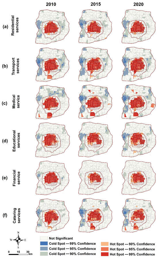
Figure 4.
Hotspot analysis of key functions in Beijing, 2010–2020.
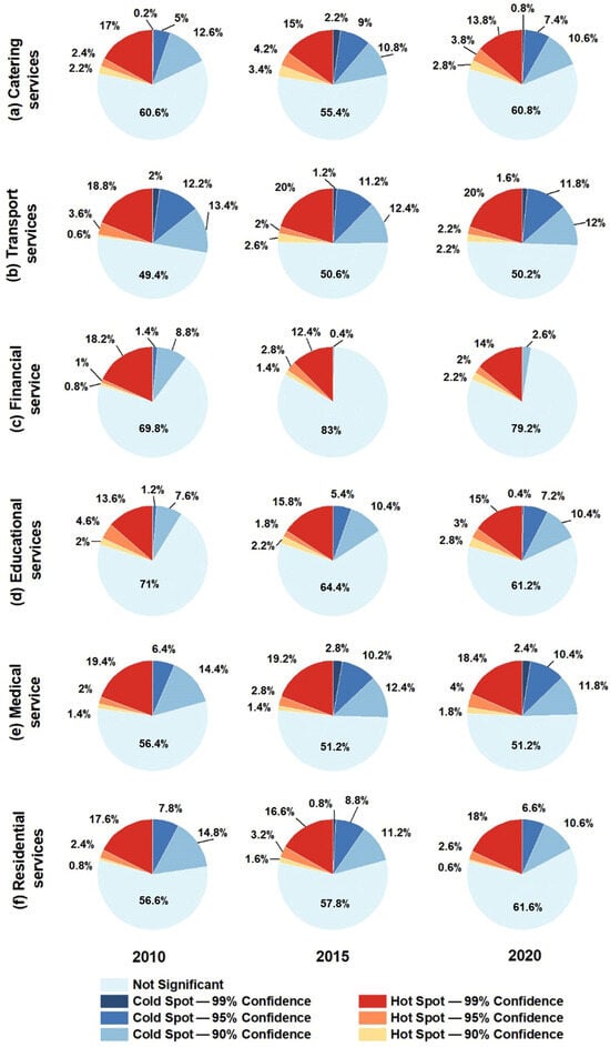
Figure 5.
Percentage chart of key functional hotspot analysis in Beijing, 2010–2020.
The results indicate that transport services and residential services have the highest hotspot coverage, reflecting their central role in urban life. Emerging hotspots for transport services appear near the Daxing subway line, medical service hotspots extend along the north–south axis, and educational services remain concentrated within the Haidian District. Catering and financial services show more peripheral development patterns. Quantitatively, hotspot areas grew as follows: medical services +1.4%, transport services +1.4%, catering services −1.4%, and financial services −1.8%.
These patterns reveal spatial clustering driven by infrastructure expansion and urban policy, with clear temporal trends that correlate with Beijing’s ring-road development and suburbanization processes.
3.2. Kernel Density Estimation Results
Kernel density analysis (Figure 6, Table 3) shows that urban function density rankings are catering > transport > educational > medical > financial > residential services. From 2010 to 2020, medical services experienced the fastest growth (133.6%), followed by transport (130.5%) and educational services (94.8%). Residential services increased steadily (52.3%), catering services showed moderate growth (9.2%), and financial services decreased (−5.9%).
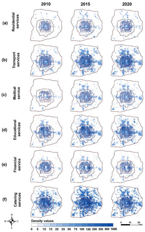
Figure 6.
Results of kernel density analysis of urban functions in Beijing.
Table 3.
Mean values of kernel density analyses of urban functions in Beijing from 2010 to 2020.
These results quantitatively confirm that service-oriented functions, especially transport and medical services, expanded rapidly within high-density urban cores, reflecting both population growth and infrastructure investment.
3.3. Evolution of the Overall Layout of Urban Functional Areas
Using LUCC, POI, and socioeconomic indicators (population and GDP), we reconstructed Beijing’s urban functional evolution over four decades (Figure 7). A dominant function method bridged LUCC and POI data, allowing long-term identification of functional areas: 1980–2010 relied on LUCC with historical maps and socioeconomic data, while 2010–2020 used POI-dominated data with LUCC supplementation to refine functional zones.
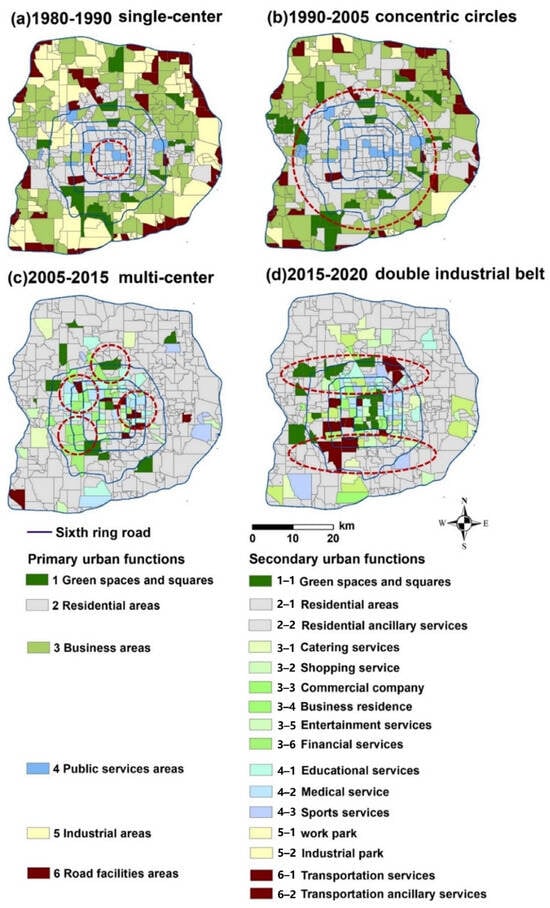
Figure 7.
Spatial and temporal evolution of functional areas in Beijing from 1980 to 2020; (a,b) refer to the legend in the left column, and (c,d) refer to the legend in the right column.
The evolution reveals four distinct stages:
- (1)
- 1980–1990 (Figure 7a): Single-center mode—Urban functions were concentrated around Tiananmen Square, with residential areas inside the 4th Ring Road and industrial zones extending outward. Functional layout was largely determined by land use types.
- (2)
- 1990–2005 (Figure 7b): Concentric-circle expansion—Rapid population growth (~3 million increase by 2000) and ring-road infrastructure promoted expansion of residential and business functions between the 3rd–5th Ring Roads, while central districts retained high functional density.
- (3)
- 2005–2015 (Figure 7c): Multi-center development—Policy-driven suburbanization led to new commercial, residential, and educational centers (e.g., Guomao, Xidan, Haidian District), complemented by continued high-density functions in the inner city.
- (4)
- 2015–2020 (Figure 7d): “One district+double industrial belt+multi-center”—A polycentric urban form emerged, featuring a northern high-tech belt (Haidian, Changping, Chaoyang), a southern industrial belt (Fengtai, Daxing, Fangshan), traditional central business areas (2nd Ring Road, Xidan), and multiple sub-centers. The ring-road network reinforced connectivity and functional mixing, while suburbanization trends intensified.
These stages illustrate the dynamic coupling of urban planning, transportation infrastructure, and functional evolution, reflecting Beijing-specific policies, demographic pressures, and strategic development plans. The transition from monocentric to polycentric patterns highlights measurable spatiotemporal trends, providing a robust basis for urban modeling, planning, and sustainable functional optimization in megacities.
4. Discussion
4.1. Inspection of Urban Function Evolution Characteristics
The hotspot growth trend of urban functions (Section 3.1) is examined using educational services as an example. The increase or decrease in the number of POI records for educational services from 2010 to 2020 was calculated (Figure 8a) and compared with the hotspot expansion area for educational services from 2010 to 2020 (Figure 8b), in which the increased area is assigned a value of 1 and the rest of the area is 0. The results show that the total areas of hotspot increase for educational services (the green color in Figure 8b) are basically in line with the area with a high growth rate of POI records (the number of increasing records is greater than 200). Specifically, the POI data of the education services is highest in the northwestern area within the 4th Ring Road (primarily in Haidian District), and the hotspot expansion area of educational services is mainly between the 3rd and 4th Ring Roads.
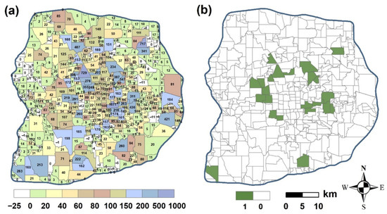
Figure 8.
Accuracy testing of educational services; (a) shows changes in the number of POI records in educational services, and (b) shows the trend expansion of functional hotspots in educational services.
To evaluate the accuracy of functional unit classification (Section 3.3), we conducted validation using multiple reference sources, including the Beijing Urban Master Plan (2004–2020) [44], the 2015 Beijing Residents’ Travelling Survey [45], Google Maps, and remote sensing data.
For educational services (Figure 7c), thirty UFAs were selected for validation. The number was determined by a stratified sampling strategy to ensure statistical representativeness across all major functional categories and a balanced spatial distribution within the 6th Ring Road. The sample size also reflects a methodological compromise between sufficient coverage and practical feasibility for detailed manual verification. Units were selected to cover both high-density urban cores and lower-density peripheral areas.
Similarly, for green space (scenic spots), twenty UFAs were selected. Here, the smaller number reflects the lower frequency of such parcels in the study area, while still ensuring spatial coverage across administrative districts. For other categories (e.g., transport, financial, and medical services), proportional samples were taken based on category size and validated using the same multi-source approach.
Overall, validation samples across categories consistently showed agreement rates above 60% with reference data (Table 4), supporting the robustness of the classification method for long-term functional evolution analysis in Beijing.
Table 4.
Comparison of the results of the identification of Beijing’s secondary urban functional units and the Beijing Urban Master Plan.
4.2. Spatial and Temporal Evolution Trend
In the pre-urbanization period (1980–2000), land development decisions were the main driver of the formation and evolution of urban functional patterns. Since 1990, more than 55% of the world’s population has lived in cities. The rapid growth of urban centers and residents, land scarcity, the emergence of more functional urban types, and technological advances are examples of the current drivers of land use and cover change. An analysis of the land profit transfer matrix in Beijing shows (Figure 9) that the amount of change (1980–2020) in each land category is ranked as follows: construction land (1268.96 km2) > unused land (−0.09 km2) > grassland (−1.56 km2) > water (−54.98 km2) > woodland (−65.7 km2) > cropland (−1146.56 km2). Among them, the growth of construction land is mainly from cropland (1168.19 km2), woodland (56.19 km2), and water (50.18 km2). In parallel with the strong development of residential services and financial services in cities, the out-migration of industrial services, the large reduction in cropland, the reclamation of unused land, and the shrinking of the area of urban green space have occurred. Wnęk and Kudas [46], in an analysis of Poland, noted that the increase in woodland and construction land came at the cost of the cropland. Li [47] noted the Eastern European trend of urbanization with a decrease in woodland, cropland, and unused land. At the same time, the urbanization development pattern of sprawling land development has triggered a variety of ecological security issues, such as land degradation, food security, and biodiversity loss.
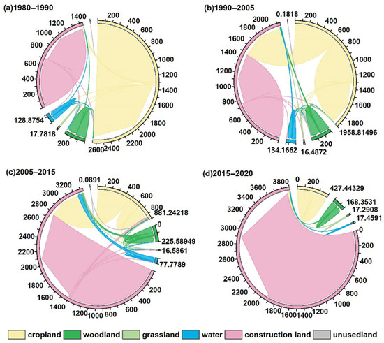
Figure 9.
Chordal plot of different land use changes in Beijing, 1980–2020.
The residential function has the most significant growth trend in urbanization. In numerous studies, residential services mainly show a tendency to expand outward from the city center or to move outward to the outskirts of the city [48]. Among these, the population’s demand for housing is the primary driver of urban expansion [49]. This study found that Beijing’s densely populated urban areas were only within the 3rd Ring Road before 1990. However, after 2000, the densely populated areas have been extended to the 4th and 5th Ring Roads (Figure 7a). By 2020, the population density within the 6th Ring Road of Beijing, especially in the Xicheng and Dongcheng districts, had reached 24,517 people/km2, far exceeding the city’s carrying capacity. At the same time, Beijing’s migrant population exceeds 50%, and the population inversion phenomenon is obvious. Beijing’s continued growth in residential demand and built-up areas threatens the city’s ecological security and sustainable development and is gradually moving towards suburbanization. Similarly, the findings of this study are consistent with those of other urban areas. For example, suburbanization is also evident outside the capital cities of post-socialist countries, such as the city of Krakow in Poland [50], and St Petersburg and Vilnius in the USSR [51].
Population density growth plays a significant driving role in the functional evolution of cities, and urban spatial functional differentiation is another factor that influences the spatial and temporal distribution of urban population density. These two factors affect each other [52]. Rapid urbanization and global population growth have led to a surge in the number of city dwellers from 751 million in 1950 to 4.2 billion in 2018. The rapid urbanization has led to the rapid growth of surrounding cities or towns, forming a polycentric urban pattern. Therefore, rationally controlling the growth of urban population density and guiding the population out of the central city is fundamental to dissolving the current level of urban functional density. This is despite the fact that Beijing’s demographics show a net outflow of population, as shown in Table 5, which shows a 0.05% decline in the number of people in the city in 2020. However, the population of the city center is not decreasing. Part of the reason for the above may be that colleges and universities are usually concentrated in the city centers. In addition, properties in the inner city are more attractive to investors [53]. For example, Beijing’s 6th Ring Road shows a clear functional separation of jobs and residences, nearly 1.8 times the ratio of jobs to residences, because most job opportunities are still clustered in the city center. Therefore, the deconcentration and outward relocation of jobs is one of the better solutions to the concentration of functions in urban centers.
Table 5.
Beijing population statistics (from the Beijing Statistical Yearbook, https://nj.tjj.beijing.gov.cn, accessed on 28 July 2025).
Transport services also dominate the formation and evolution of urban spatial structures [54]. Meanwhile, it further contributes to the high density of urban functions. Before 2000, Beijing’s transport services were highly concentrated between the 4th and 5th Ring Roads, playing a role in taking over the production and residential functions inside and outside of the 4th Ring Road. The shift toward multi-centers after 2005 corresponds to polycentric morphology, which can promote spatial justice by distributing services more evenly across districts. After 2010, the Ring Roads’ clear economic development belt was gradually formed. In a study of the impact of urban transportation expansion on the spatial structure of American cities, Baum-Snow [55] proposes that between 1960 and 2000, each new radial highway serving a metropolitan area in the United States dispersed 14 to 16 percent of working residents in the central city and 4 to 6 percent of the jobs. After 2015, the rapid growth and density of transport facilities on the 4th Ring Road of Beijing had reached saturation, and the traffic pressure within the 5th Ring Road was extremely heavy during morning and evening peak hours. According to the statistics from 2020, the traffic index is 8.7, and the average speed is only 15.7 km/h in Beijing. Such distress also exists in cities in North America [56] and Europe [57]. Furthermore, heavy traffic also causes severe air pollution and frequent dusty weather [58,59]. Therefore, alleviating overcrowding in high-density residential areas within the 4th and 5th Ring Roads—through redistributing the population to suburban districts and improving public transit connectivity—can reduce local traffic congestion, lower air pollution concentrations, and thereby improve environmental quality and residents’ health.
4.3. Existing Problems and Suggestions of Urban Functional Layout
In this study, the results show an over-concentration of functions within the 6th Ring Road in Beijing, as the activity areas of residents for work, entertainment, and shopping are dominated by those within the 4th Ring Road (Figure 7c,d), with the number of POIs within the 4th Ring Road accounting for 80% of the total. In fact, the mix of functions in some units has seriously exceeded their own carrying capacity, which poses a severe obstacle to Beijing’s sustainable development and ecological protection. Similarly, in a study by Yeh and Chen [60], it is pointed out that Chinese megacities, such as Shanghai and Guangzhou, are also facing the problem of dense urban functions in the new wave of urbanization and economic transformation. Globally, cities like São Paulo, Mexico City, and Johannesburg also face similar challenges related to over-concentration and spatial inequality, where urban sprawl and centralized function have exacerbated social and environmental issues [61,62]. These cases suggest that urban planning frameworks, especially spatial justice and urban morphology theories, can be valuable in addressing these imbalances by promoting more equitable and sustainable spatial distribution [63].
To address the over-concentration of urban functions within central Beijing, the first step is to relocate non-capital functions—such as logistics centers, large exhibition halls, and low-end manufacturing—primarily located in the 4th–5th Ring Road corridor, to suburban areas or the Xiongan New Area, thereby freeing up space for capital-critical functions and reducing pressure on the urban core [64]. In a study by Gant and Robinson [65], tertiary industries in developed countries such as Europe, the United States, and Japan have recently shifted to the suburbs. The Beijing government is also helping to disperse the population and functions of the central district. With the completion of the Xiongan New Area, the urban functions of Beijing’s sub-center will be shifted accordingly to attract more population and functions from the central area and ease the pressure on the city center. This follows the global trend of Transit-Oriented Development (TOD), which has successfully been applied in cities such as Curitiba (Brazil), Ahmedabad (India), and Addis Ababa (Ethiopia), where TOD-based strategies have alleviated traffic congestion and improved accessibility in suburban areas [66,67]. These cases demonstrate the global applicability of TOD in mitigating urban sprawl while promoting sustainable transportation systems [68].
At the same time, it will also provide an exemplary case for the global construction of a new model of inclusive cities, the construction of a metropolitan area, and the realization of the Millennium Sustainable Development Goals [69,70,71]. The adoption of spatial justice frameworks could guide how urban functions are distributed more equitably within metropolitan regions, ensuring access to essential services for all socioeconomic groups and helping reduce spatial inequalities.
Urban green space plays an important role in urban human ecosystems by helping regulate the urban ecosystem and improving residents’ livability. However, the continuous evolution of cities has led to the continuous crowding of ecological space. According to a study by Deng and Wang [72], more than 312 species of habitats in China have suffered degradation or loss in this process. Moreover, the results of this study show that the high-density functional facilities and construction land within the 6th Ring Road of Beijing have been increasing (179.10%) during the process of urbanization, and the total area of green space (cropland, woodland, and grassland) has shrunk by 86.97%, which is seriously out of balance with the other land types in the city. In Latin American cities such as Buenos Aires and Lima, urban sprawl has similarly reduced green spaces, leading to unsustainable environmental degradation [73,74]. Therefore, Beijing should strategically allocate and optimize urban construction land, prioritizing the redevelopment of underutilized areas within the 4th–6th Ring Roads, promoting mixed-use development, and enhancing green infrastructure, to achieve a balanced urban structure while maintaining ecological safety thresholds [75]. Specifically, the construction of greenways in the central and old urban areas should be promoted, and a number of new comprehensive parks, wetland parks, and country parks should be built to form an urban green ecological network [76]. Simultaneously, Beijing can further enhance the carbon sequestration capacity of urban ecosystems by expanding green corridors, developing new urban parks and wetlands, and promoting the greening of rooftops and streetscapes, integrating ecological benefits with urban livability. This study’s findings contribute to advancing SDG 11 (Sustainable Cities and Communities) by offering actionable insights for improving urban functional layouts and mitigating the negative impacts of rapid urbanization [77]. The prioritization of population control, the expansion of green spaces, and improvements to suburban transportation infrastructure align with key SDG targets related to urban sustainability, resilience, and inclusive growth [78].
Traffic congestion is a severe problem in the urbanization of Beijing. This study shows that the density of transportation facilities in Beijing is too high and is growing too fast. According to statistics, Beijing had 6,365,000 motor vehicles by 2020. And the city traffic has shown a regionalized and normalized congestion situation. Referring to cases such as the Tokyo Metropolitan Area [76], it is a fact that regions with different population densities are suitable for different modes of transportation. Compared with the international metropolis [79], Beijing has a single-level rail system, especially the large-capacity, high-efficiency suburban rail system, and regional express lines lag behind [80]. Only high-capacity, fast, and convenient rail transportation can support the huge demand of a big city like Beijing and the travel services for 30 km to 50 km circles. At the same time, different transport policies should be implemented inside and outside the 6th Ring Road, such as congestion pricing and restricted vehicle zones in central areas, coupled with a public transport-oriented development (TOD) strategy that prioritizes high-capacity rail and bus rapid transit corridors [81]. This approach aligns with global best practices while being tailored to Beijing’s urban structure and travel demand patterns [82]. This approach has been successfully implemented in cities such as São Paulo and Mumbai, where TOD strategies have been used to combat urban sprawl and improve public transport accessibility [83].
Excessive concentration of functions in megacities has become a common problem. Beijing, as a global megacity, is representative. This study divides the urban functional units by “street+road network” and considers the relationship between human activities and the city’s physical structure, which is also applicable to other cities. Based on this, this study puts forward the following suggestions for the existing major urban problems in Beijing. First, improving high-capacity, fast, and convenient rail transportation to support 30–50 km circle travel, along with implementing differentiated traffic policies inside and outside the 6th Ring Road, is essential to complement population relocation and enhance urban mobility [84]. Second, controlling population density and relocating residential and functional units out of the central city is prioritized, as over-concentration within the 4th and 6th Ring Roads is the primary driver of congestion, high land use intensity, and ecological pressure [85]. This first step lays the foundation for all subsequent measures. Third, expanding green space, promoting the ecological transformation of old urban areas, and constructing green corridors are prioritized after population and transport pressures are alleviated, allowing more effective ecological and carbon sink enhancement. Fourth, integrating the Beijing–Tianjin–Hebei regions and implementing the Xiongan New Area capital sub-center planning are long-term strategic measures that depend on the previous steps, ensuring coordinated regional development and sustainable relocation of capital functions. These structural adjustments are long-term strategies that involve high costs and long implementation times. Therefore, they should be regarded as phased measures, with short- and medium-term efforts focusing on gradual population dispersion, transport enhancement, and ecological restoration, while the regional integration will unfold progressively over time.
The findings can also support urban master planning in these cities by offering a structured approach to balancing economic, social, and environmental needs, enhancing the potential for sustainable urban transformation in developing countries. The use of multi-source spatiotemporal data, including POI, LUCC, and transportation networks [74,75,76,77], allows urban planners in cities worldwide to assess urban function evolution over time, ensuring more informed, data-driven planning decisions that support SDG implementation.
4.4. Limitations and Future Research Directions
This study also has some shortcomings. In the delineation of functional units, the neighborhood-based functional unit delineation also shows differences between the intersections of neighborhoods and roads. Meanwhile, in the POI-based spatial connection and identification, this study found that the POI types within some neighborhoods differed from those near the streets. This individual variability of big data is not yet possible for finer classification and correction with our existing statistical capability. Therefore, how to define urban functional study units more precisely and correct statistical differences in big data more efficiently is also one of the directions of our future research endeavors.
5. Conclusions
This study reconstructs the long-term evolution of urban functions within Beijing’s 6th Ring Road (1980–2020) using a multi-source “LUCC+POI+socioeconomic data” framework. The results show the following: (1) Rapid expansion of transport and residential services, forming ring-road economic belts and concentrated high-density zones. (2) Four distinct evolutionary stages, from a single-center structure (1980–1990) to concentric-circle expansion (1990–2005), multi-center development (2005–2015), and a “one district–double industrial belt–multi-center” pattern (2015–2020). (3) The gradual emergence of multi-centered and suburbanized functional structures driven by infrastructure, population growth, and policy interventions. Policy priorities should focus on controlling population and functional density, strengthening high-capacity transport systems, expanding urban green space, and promoting coordinated regional development.
Overall, this study provides a data-driven framework for analyzing functional transformation in megacities. The Beijing case illustrates both the risks of over-concentration and the potential pathways toward balanced spatial development, offering transferable insights for sustainable urban planning in other rapidly urbanizing regions worldwide.
Author Contributions
Initial idea and research plan were provided by M.Z. and X.Z. Material preparation, data collection, and analysis were performed by J.L. and H.J. The first draft of the manuscript was written by J.L. and M.Z., and all authors commented on previous versions of the manuscript. M.Z. and X.Z. provided project support. All authors have read and agreed to the published version of the manuscript.
Funding
This research was supported by the National Natural Science Foundation of China, No. 42201471, the Fundamental Research Funds for the Central Universities (the Research Funds of Renmin University of China), No. 22XNF010 and Key Program of National Natural Science Foundation of China, No. 72033005.
Data Availability Statement
The datasets used and/or analyzed during the current study are not publicly available due to General Data Protection Regulations; however, they are available from the corresponding author upon reasonable request.
Conflicts of Interest
The authors declare no conflicts of interest.
References
- Follmann, A. Geographies of peri-urbanization in the global south. Geogr. Compass 2022, 16, e12650. [Google Scholar] [CrossRef]
- Wang, H.; He, Q.; Liu, X.; Zhuang, Y.; Hong, S. Global urbanization research from 1991 to 2009: A systematic research review. Landsc. Urban Plan. 2012, 104, 299–309. [Google Scholar] [CrossRef]
- Liu, X.; Niu, N.; Liu, X.; Jin, H.; Ou, J.; Jiao, L.; Liu, Y. Characterizing mixed-use buildings based on multi-source big data. Int. J. Geogr. Inf. Sci. 2018, 32, 738–756. [Google Scholar]
- Zhou, D.; Xu, J.; Wang, L.; Lin, Z. Assessing urbanization quality using structure and function analyses: A case study of the urban agglomeration around Hangzhou Bay (UAHB), China. Habitat Int. 2015, 49, 165–176. [Google Scholar] [CrossRef]
- Li, L.; Yang, Q.; Xie, X. Coupling coordinated evolution and forecast of tourism-urbanization-ecological environment: The case study of Chongqing, China. Math. Probl. Eng. 2021, 2021, 7271637. [Google Scholar] [CrossRef]
- Burgess, E.W. Residential segregation in American cities. Ann. Am. Acad. Political Soc. Sci. 1928, 140, 105–115. [Google Scholar] [CrossRef]
- Hoyt, H. The structure of American cities in the post-war era. Am. J. Sociol. 1943, 48, 475–481. [Google Scholar] [CrossRef]
- Harris, C.D.; Ullman, E.L. The nature of cities. Ann. Am. Acad. Political Soc. Sci. 1945, 242, 7–17. [Google Scholar] [CrossRef]
- Sheng, K.; Sun, W.; Fan, J. Sequential city growth: Theory and evidence from the US. J. Geogr. Sci. 2014, 24, 1161–1174. [Google Scholar] [CrossRef]
- Howard, E. Garden cities: A solution of the housing problem. J. Sanit. Inst. 1902, 23, 670–674. [Google Scholar] [CrossRef]
- Perry, C.A. City planning for neighborhood life. Soc. Forces 1929, 8, 98. [Google Scholar] [CrossRef]
- Reichow, H.B. Organische Stadtbaukunst: Von der Großstadt zur Stadtlandschaft; Georg Westermann: Braunschweig, Germany, 1948. [Google Scholar]
- Chen, S.S.; Yan, Y.; Gao, Q.; Liu, D. Quantifying circular urban expansion patterns of compact Chinese cities: The case of Yangtze River Delta, China. Environ. Plan. B Plan. Des. 2015, 42, 279–299. [Google Scholar] [CrossRef]
- Cheng, H.; Liu, Y.; He, S.; Shaw, D. From development zones to edge urban areas in China: A case study of Nansha, Guangzhou City. Cities 2017, 71, 110–122. [Google Scholar] [CrossRef]
- Fan, J.; Ma, T.; Zhou, C.; Zhou, Y.; Xu, T. Comparative estimation of urban development in China’s cities using socioeconomic and DMSP/OLS night light data. Remote Sens. 2014, 6, 7840–7856. [Google Scholar] [CrossRef]
- Surya, B.; Salim, A.; Hernita, H.; Suriani, S.; Menne, F.; Rasyidi, E.S. Land use change, urban agglomeration, and urban sprawl: A sustainable development perspective of Makassar City, Indonesia. Land 2021, 10, 556. [Google Scholar] [CrossRef]
- Saberi, M.; Hamedmoghadam, H.; Ashfaq, M.; Hosseini, S.A.; Gu, Z.; Shafiei, S.; Nair, D.J.; Dixit, V.; Gardner, L.; Waller, S.T.; et al. A simple contagion process describes spreading of traffic jams in urban networks. Nat. Commun. 2020, 11, 1616. [Google Scholar] [CrossRef]
- Wang, F.; Li, J.; Yu, F.; He, H.; Zhen, F. Space, function, and vitality in historic areas: The tourismification process and spatial order of Shichahai in Beijing. Int. J. Tour. Res. 2018, 20, 335–344. [Google Scholar] [CrossRef]
- Carranza, J.P.; Piumetto, M.A.; Lucca, C.M.; Da Silva, E. Mass appraisal as affordable public policy: Open data and machine learning for mapping urban land values. Land Use Policy 2022, 119, 106211. [Google Scholar] [CrossRef]
- Yi, D.; Yang, J.; Liu, J.; Liu, Y.; Zhang, J. Quantitative identification of urban functions with fishers’ exact test and POI data applied in classifying urban districts: A case study within the sixth ring road in Beijing. ISPRS Int. J. Geo-Inf. 2019, 8, 555. [Google Scholar] [CrossRef]
- Pisano, C. Strategies for post-COVID cities: An insight to Paris En Commun and Milano 2020. Sustainability 2020, 12, 5883. [Google Scholar] [CrossRef]
- Frago, L. Impact of COVID-19 pandemic on retail structure in barcelona: From tourism-phobia to the desertification of city center. Sustainability 2021, 13, 8215. [Google Scholar] [CrossRef]
- Lynch, K. The Image of the City; The MIT Press: Cambridge, MA, USA, 1960. [Google Scholar]
- Venturi, R. Complexity and Contradiction in Architecture; The Museum of Modern Art: New York, NY, USA, 1977; Volume 1. [Google Scholar]
- Fertner, C.; Jørgensen, G.; Nielsen, T.A.S.; Nilsson, K.S.B. Urban sprawl and growth management–drivers, impacts and responses in selected European and US cities. Future Cities Environ. 2016, 2, 9. [Google Scholar] [CrossRef]
- He, Q.; Song, Y.; Liu, Y.; Yin, C. Diffusion or coalescence? Urban growth pattern and change in 363 Chinese cities from 1995 to 2015. Sustain. Cities Soc. 2017, 35, 729–739. [Google Scholar] [CrossRef]
- Gao, Z.; Tan, N.; Geddes, R.R.; Ma, T. Population distribution characteristics and spatial planning response analysis in metropolises: A case study of Beijing. Int. Rev. Spat. Plan. Sustain. Dev. 2019, 7, 134–154. [Google Scholar] [CrossRef]
- Peng, J.; Liu, Z.; Liu, Y.; Hu, X.; Wang, A. Multifunctionality assessment of urban agriculture in Beijing City, China. Sci. Total Environ. 2015, 537, 343–351. [Google Scholar] [CrossRef]
- Zhang, N.; Zhang, J.; Chen, W.; Su, J. Block-based variations in the impact of characteristics of urban functional zones on the urban heat island effect: A case study of Beijing. Sustain. Cities Soc. 2022, 76, 103529. [Google Scholar] [CrossRef]
- Wang, J.; Deng, Y.; Song, C.; Tian, D. Measuring time accessibility and its spatial characteristics in the urban areas of Beijing. J. Geogr. Sci. 2016, 26, 1754–1768. [Google Scholar] [CrossRef]
- Yu, D.; Yanxu, L.; Bojie, F. Urban growth simulation guided by ecological constraints in Beijing city: Methods and implications for spatial planning. J. Environ. Manag. 2019, 243, 402–410. [Google Scholar] [CrossRef] [PubMed]
- Ma, Y.; Xu, W.; Zhao, X.; Li, Y. Modeling the hourly distribution of population at a high spatiotemporal resolution using subway smart card data: A case study in the central area of Beijing. ISPRS Int. J. Geo-Inf. 2017, 6, 128. [Google Scholar] [CrossRef]
- Resource and Environment Science and Data Center (RESDC), Chinese Academy of Sciences. Resource and Environment Data Cloud Platform. 2021. Available online: http://www.resdc.cn/Datalist1.aspx?FieldTyepID=9,13 (accessed on 28 July 2025).
- Wang, Z.; Ma, D.; Sun, D.; Zhang, J. Identification and analysis of urban functional area in Hangzhou based on OSM and POI data. PLoS ONE 2021, 16, e0251988. [Google Scholar] [CrossRef] [PubMed]
- Jun, Z.; Xiao-Die, Y.; Han, L. The extraction of urban built-up areas by integrating night-time light and POI data—A case study of Kunming, China. IEEE Access 2021, 9, 22417–22429. [Google Scholar] [CrossRef]
- GB50137-2011; Urban Land Use Classification and Planning Construction Land Use Standard. Ministry of Housing and Urban-Rural Development of the People’s Republic of China: Beijing, China, 2011.
- GB/T21010-2017; Classification of Land Use Status Quo. Standardization Administration of China: Beijing, China, 2017.
- Beijing Municipal Bureau of Statistics. Beijing Statistical Yearbook (1949–2020); China Statistics Press: Beijing, China, 2021. [Google Scholar]
- Luo, S.; Liu, Y.; Du, M.; Gao, S.; Wang, P.; Liu, X. The influence of spatial grid division on the layout analysis of urban functional areas. ISPRS Int. J. Geo-Inf. 2021, 10, 189. [Google Scholar] [CrossRef]
- Xu, S.; Qing, L.; Han, L.; Liu, M.; Peng, Y.; Shen, L. A new remote sensing images and point-of-interest fused (RPF) model for sensing urban functional regions. Remote Sens. 2020, 12, 1032. [Google Scholar] [CrossRef]
- Lin, Y.-P.; Chu, H.J.; Wu, C.F.; Chang, T.K.; Chen, C.Y. Hotspot analysis of spatial environmental pollutants using kernel density estimation and geostatistical techniques. Int. J. Environ. Res. Public Health 2011, 8, 75–88. [Google Scholar] [CrossRef]
- Getis, A.; Ord, J.K. The analysis of spatial association by use of distance statistics. Geogr. Anal. 1992, 24, 189–206. [Google Scholar] [CrossRef]
- Hou, G.; Chen, L. Regional commercial center identification based on POI big data in China. Arab. J. Geosci. 2021, 14, 1360. [Google Scholar] [CrossRef]
- Beijing Municipal Commission of Urban Planning. Beijing Urban Master Plan (2004–2020); Beijing Municipal Government: Beijing, China, 2005. [Google Scholar]
- Beijing Transport Institute. Beijing Residents’ Travelling Survey (2015); Beijing Transport Institute: Beijing, China, 2016. [Google Scholar]
- Wnęk, A.; Kudas, D.; Stych, P. National level land-use changes in functional urban areas in Poland, Slovakia, and Czechia. Land 2021, 10, 39. [Google Scholar] [CrossRef]
- Li, Z.-T.; Li, M.; Xia, B.-C. Spatio-temporal dynamics of ecological security pattern of the Pearl River Delta urban agglomeration based on LUCC simulation. Ecol. Indic. 2020, 114, 106319. [Google Scholar] [CrossRef]
- Wang, C.; Engels, A.; Wang, Z. Overview of research on China’s transition to low-carbon development: The role of cities, technologies, industries and the energy system. Renew. Sustain. Energy Rev. 2018, 81, 1350–1364. [Google Scholar] [CrossRef]
- Xu, Q.; Zheng, X.; Zhang, C. Quantitative analysis of the determinants influencing urban expansion: A case study in Beijing, China. Sustainability 2018, 10, 1630. [Google Scholar] [CrossRef]
- Haase, A.; Grossmann, K.; Steinführer, A. Transitory urbanites: New actors of residential change in Polish and Czech inner cities. Cities 2012, 29, 318–326. [Google Scholar] [CrossRef]
- Axenov, K.; Krupickaitė, D.; Morachevskaya, K.; Zinovyev, A. Retail sprawl in post-Soviet urban residential communities: Case studies of Saint-Petersburg and Vilnius. Morav. Geogr. Rep. 2018, 26, 210–219. [Google Scholar] [CrossRef]
- Źróbek-Różańska, A.; Zadworny, D. Can urban sprawl lead to urban people governing rural areas? Evidence from the Dywity Commune, Poland. Cities 2016, 59, 57–65. [Google Scholar] [CrossRef]
- Li, T.; Zheng, X.; Zhang, C.; Wang, R.; Liu, J. Mining Spatial Correlation Patterns of the Urban Functional Areas in Urban Agglomeration: A Case Study of Four Typical Urban Agglomerations in China. Land 2022, 11, 870. [Google Scholar] [CrossRef]
- Li, Y.; Xiong, W.; Wang, X. Does polycentric and compact development alleviate urban traffic congestion? A case study of 98 Chinese cities. Cities 2019, 88, 100–111. [Google Scholar] [CrossRef]
- Baum-Snow, N. Urban transport expansions and changes in the spatial structure of us cities: Implications for productivity and welfare. Rev. Econ. Stat. 2020, 102, 929–945. [Google Scholar] [CrossRef]
- Kramer, A. The unaffordable city: Housing and transit in North American cities. Cities 2018, 83, 1–10. [Google Scholar] [CrossRef]
- Xu, X.; Zhang, D.; Liu, X.; Ou, J.; Wu, X. Simulating multiple urban land use changes by integrating transportation accessibility and a vector-based cellular automata: A case study on city of Toronto. Geo-Spat. Inf. Sci. 2022, 25, 439–456. [Google Scholar] [CrossRef]
- Duan, Z.; Yang, Y.; Zhang, K.; Ni, Y.; Bajgain, S. Improved deep hybrid networks for urban traffic flow prediction using trajectory data. IEEE Access 2018, 6, 31820–31827. [Google Scholar] [CrossRef]
- Zhao, P.; Hu, H. Geographical patterns of traffic congestion in growing megacities: Big data analytics from Beijing. Cities 2019, 92, 164–174. [Google Scholar] [CrossRef]
- Yeh, A.G.-O.; Chen, Z. From cities to super mega city regions in China in a new wave of urbanisation and economic transition: Issues and challenges. Urban Stud. 2020, 57, 636–654. [Google Scholar] [CrossRef]
- Kotkin, J. The Human City: Urbanism for the Rest of Us; Agate Publishing: Evanston, IL, USA, 2016. [Google Scholar]
- Wolff, M. Understanding the role of centralization processes for cities–Evidence from a spatial perspective of urban Europe 1990–2010. Cities 2018, 75, 20–29. [Google Scholar] [CrossRef]
- Deng, H.; Zhang, K.; Wang, F.; Dang, A. Compact or disperse? Evolution patterns and coupling of urban land expansion and population distribution evolution of major cities in China, 1998–2018. Habitat Int. 2021, 108, 102324. [Google Scholar] [CrossRef]
- Li, Z.; Jiao, L.; Zhang, B.; Xu, G.; Liu, J. Understanding the pattern and mechanism of spatial concentration of urban land use, population and economic activities: A case study in Wuhan, China. Geo-Spat. Inf. Sci. 2021, 24, 678–694. [Google Scholar] [CrossRef]
- Gant, R.L.; Robinson, G.M.; Fazal, S. Land-use change in the ‘edgelands’: Policies and pressures in London’s rural–urban fringe. Land Use Policy 2011, 28, 266–279. [Google Scholar] [CrossRef]
- Cervero, R.; Dai, D. BRT TOD: Leveraging transit oriented development with bus rapid transit investments. Transp. Policy 2014, 36, 127–138. [Google Scholar] [CrossRef]
- Xu, W.; Guthrie, A.; Fan, Y.; Li, Y. Transit-oriented development in China: Literature review and evaluation of TOD potential across 50 Chinese cities. J. Transp. Land Use 2017, 10, 743–762. [Google Scholar] [CrossRef]
- Ibrahim, S.M.; Ayad, H.M.; Saadallah, D.M. Planning transit-oriented development (TOD): A systematic literature review of measuring the transit-oriented development levels. Int. J. Transp. Dev. Integr. 2022, 6, 378–398. [Google Scholar] [CrossRef]
- Liu, Z.; de Jong, M.; Li, F.; Brand, N.; Hertogh, M.; Dong, L. Towards developing a new model for inclusive cities in China—The case of Xiong’an New Area. Sustainability 2020, 12, 6195. [Google Scholar] [CrossRef]
- Zou, Y.; Chen, Z.; Zhong, N.; Zhao, W. Urban planning as a way to pursue quality-oriented urbanization: Anatomy of the urban planning of Xiong’an New Area, China. J. Urban Aff. 2023, 45.8, 1418–1433. [Google Scholar] [CrossRef]
- Zou, Y.; Zhao, W. Making a new area in Xiong’an: Incentives and challenges of China’s “Millennium Plan”. Geoforum 2018, 88, 45–48. [Google Scholar] [CrossRef]
- Deng, J.S.; Wang, K.; Hong, Y.; Qi, J.G. Spatio-temporal dynamics and evolution of land use change and landscape pattern in response to rapid urbanization. Landsc. Urban Plan. 2009, 92, 187–198. [Google Scholar] [CrossRef]
- de Lima, G.N.; Fonseca-Salazar, M.A.; Campo, J. Urban growth and loss of green spaces in the metropolitan areas of São Paulo and Mexico City: Effects of land-cover changes on climate and water flow regulation. Urban Ecosyst. 2023, 26, 1739–1752. [Google Scholar] [CrossRef]
- Inostroza, L.; Baur, R.; Csaplovics, E. Urban sprawl and fragmentation in Latin America: A comparison with European cities. The myth of the diffuse Latin American city. J. Environ. Manag. 2010, 115, 87–97. [Google Scholar] [CrossRef]
- Hrelja, R.; Rye, T. Delivering Transit Oriented Development (TOD) in low to medium density contexts. Actor relationships and market conditions in smaller Swedish cities. Int. J. Sustain. Transp. 2024, 18, 236–249. [Google Scholar] [CrossRef]
- Liu, Y.; Nath, N.; Murayama, A.; Manabe, R. Transit-oriented development with urban sprawl? Four phases of urban growth and policy intervention in Tokyo. Land Use Policy 2022, 112, 105854. [Google Scholar] [CrossRef]
- Wiedmann, T.; Allen, C. City footprints and SDGs provide untapped potential for assessing city sustainability. Nat. Commun. 2021, 12, 3758. [Google Scholar] [CrossRef]
- Kaiser, Z.A.; Deb, A. Sustainable smart city and Sustainable Development Goals (SDGs): A review. Reg. Sustain. 2025, 6, 100193. [Google Scholar] [CrossRef]
- Zhou, H.; Gao, H. The impact of urban morphology on urban transportation mode: A case study of Tokyo. Case Stud. Transp. Policy 2020, 8, 197–205. [Google Scholar] [CrossRef]
- Zhang, W.; Li, B. Research on an analytical framework for urban spatial structural and functional optimisation: A case study of Beijing city, China. Land 2021, 10, 86. [Google Scholar] [CrossRef]
- Leavesley, A.; Trundle, A.; Oke, C. Cities and the SDGs: Realities and possibilities of local engagement in global frameworks. Ambio 2022, 51, 1416–1432. [Google Scholar] [CrossRef] [PubMed]
- Lu, J.; Li, B.; Li, H.; Al-Barakani, A. Expansion of city scale, traffic modes, traffic congestion, and air pollution. Cities 2021, 108, 102974. [Google Scholar] [CrossRef]
- Grossi, G.; Trunova, O. Are UN SDGs useful for capturing multiple values of smart city? Cities 2021, 114, 103193. [Google Scholar] [CrossRef]
- Franco, S. Sustainable cities and communities: The road towards SDG 11. TEMA 2022, 2, 341–344. [Google Scholar]
- Tremblay, D.; Gowsy, S.; Riffon, O.; Boucher, J.F.; Dubé, S.; Villeneuve, C. A systemic approach for sustainability implementation planning at the local level by SDG target prioritization: The case of Quebec City. Sustainability 2021, 13, 2520. [Google Scholar] [CrossRef]
Disclaimer/Publisher’s Note: The statements, opinions and data contained in all publications are solely those of the individual author(s) and contributor(s) and not of MDPI and/or the editor(s). MDPI and/or the editor(s) disclaim responsibility for any injury to people or property resulting from any ideas, methods, instructions or products referred to in the content. |
© 2025 by the authors. Licensee MDPI, Basel, Switzerland. This article is an open access article distributed under the terms and conditions of the Creative Commons Attribution (CC BY) license (https://creativecommons.org/licenses/by/4.0/).