Article

Analysis of Influencing Factors on Spatial Distribution Characteristics of Traditional Villages in the Liaoxi Corridor

School of Knowledge Science, Japan Advanced Institute of Science and Technology, Nomi 9231292, Japan
*
Author to whom correspondence should be addressed.
Land 2025, 14(8), 1572; https://doi.org/10.3390/land14081572
Submission received: 20 June 2025 / Revised: 23 July 2025 / Accepted: 26 July 2025 / Published: 31 July 2025

Abstract

As a cultural corridor connecting the Central Plains and Northeast China, the Liaoxi Corridor has a special position in the transmission of traditional Chinese culture. Traditional villages in the region have preserved rich intangible cultural heritage and traditional architectural features, which highlight the historical heritage of multicultural intermingling. This study fills the gap in the spatial distribution of traditional villages in the Liaoxi Corridor and reveals their spatial distribution pattern, which is of great theoretical significance. Using Geographic Information System (GIS) spatial analysis and quantitative geography, this study analyzes the spatial pattern of traditional villages and the influencing factors. The results show that traditional villages in the Liaoxi Corridor are clustered, forming high-density settlement areas in Chaoyang County and Beizhen City. Most villages are located in hilly and mountainous areas and river valleys and are affected by the natural geographic environment (topography and water sources) and historical and human factors (immigration and settlement, border defense, ethnic integration, etc.). In conclusion, this study provides a scientific basis and practical reference for rural revitalization, cultural heritage protection, and regional coordinated development, aiming at revealing the geographical and cultural mechanisms behind the spatial distribution of traditional villages.

1. Introduction

As a significant part of China’s farming civilization, traditional villages not only highlight their historical value with their physical architectural remains and settlement patterns but also carry rich intangible cultural heritage and local identity [1,2]. Since the Ministry of Housing and Urban–Rural Development (MOHURD) initiated the release of the “Traditional Villages List” in 2012, 8155 villages were selected by 2024, which shows that the state attaches great importance to the systematic protection of traditional villages [3,4]. However, the rapid wave of urbanization is accelerating the problems of population loss, spatial fragmentation, and cultural function decline, which urgently require scientific analysis of spatial patterns and causes to provide a basis for decision-making on holistic conservation and sustainable development [5].

1.1. Spatial Pattern Types and Research Progress

Many studies conducted in China and abroad have shown that traditional villages tend to present spatial patterns of aggregation or linear aggregation at regional scales and are not uniformly distributed [6,7]. Su et al. [8] categorized village settlements into six types: aggregated, stochastic, regular, low density, high density, and linear, providing a classical framework for subsequent spatial type division. Under the functional perspective, some scholars have also classified villages into commercial, transportation, defense, religious, and seclusion types to reveal the formation and evolution mechanisms of different types of villages [9]. In terms of methodology, Geographic Information System (GIS) spatial analysis techniques have become the mainstream means, and commonly used indicators include the nearest neighbor index (R < 1 is clustering), kernel density estimation, standard deviation ellipse, and Moran’s I, which have been validated in Fujian, Jiangsu, and Hebei Provinces [10,11,12,13,14].

1.2. Drivers and Comprehensive Assessment

The study further pointed out that natural geographic conditions (e.g., topography, elevation relief, and water accessibility) are important constraints for traditional village site selection and clustering, and socioeconomic variables (population density, transportation accessibility, GDP, and industrial structure) and cultural resources (density of intangible cultural heritage, distribution of ethnic groups, etc.) also significantly affect the spatial suitability of villages [8,10,12,15,16]. Currently, methods such as Multicriteria Decision Analysis (MCDA) and Geodetector are mostly used to quantitatively assign weights to and evaluate the coupling of the above factors. However, critical comparisons of method strengths, limitations, and parameter choices are still scarce [16].

1.3. Research Area and Shortcomings

Although the above studies have enriched the understanding of traditional villages in the hilly areas and plain hinterland of Southeast China, there is no systematic analysis of the typical “cultural corridor” in northern China, namely, the Liaoxi Corridor (Appendix A.1). Since ancient times, the Liaoxi Corridor has been a major trade and military route from North China to Northeast China, possessing unique landscape resources that reflect multi-ethnic cultural intermingling and playing a crucial role in the evolution of frontier defense [17]. Though there are some studies on cultural heritage and tourism development, there is a lack of studies using GIS and spatial measurement methods to analyze the spatial pattern and genesis mechanism of traditional villages [18,19].

1.4. Research Objectives and Innovations

To address the above limitations, this study considers 52 traditional villages in the Liaoxi Corridor as the research object, combines GIS spatial analysis with MCDA quantitative modeling, and aims to answer the following questions:
  • Do traditional villages in the Liaoxi Corridor exhibit significant spatial aggregation or linear distribution characteristics?
  • How do factors such as natural geography, human society, and cultural resources jointly drive the spatial distribution of villages?
  • How do regional characteristics affect the above driving mechanisms, and what are the similarities and differences with studies in the southeast?
This study will make the following contributions to the classification of spatial aggregation and distribution types, factor coupling analysis, and suitability assessment:
  • Filling the regional research gap: the first systematic revelation of the spatial pattern of traditional villages in the northern cultural corridor.
  • Methodological refinement: critical comparison in MCDA assignment and parameter selection, and combination of spatial autocorrelation indicators.
  • Practical significance: to provide the classification, conservation, and rural revitalization of the Liaoxi Corridor and provide quantitative decision support.

2. Materials and Methods

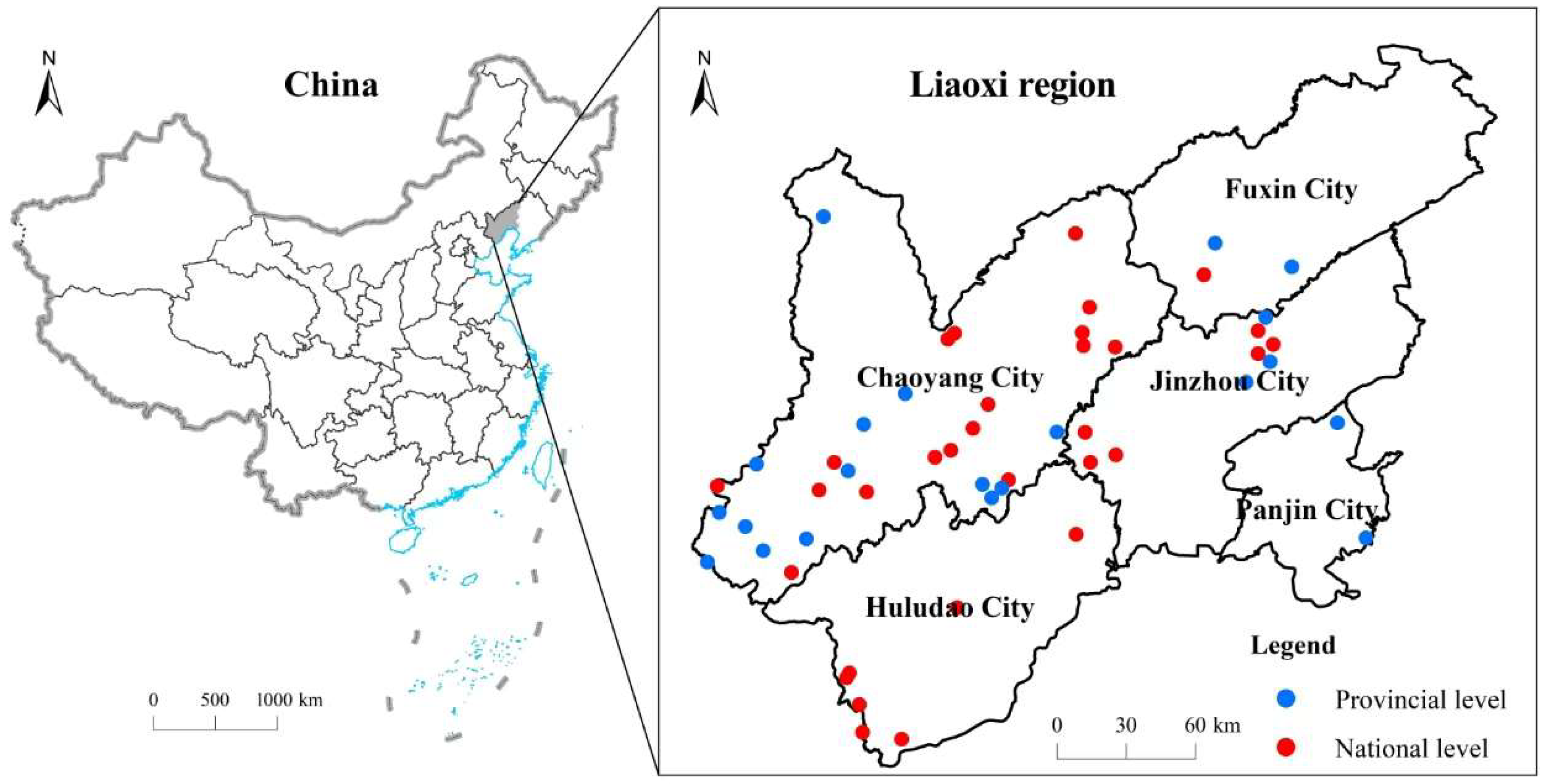
2.1. Overview of the Study Area

Located in the western part of Liaoning Province, with the coastal plain area of Liaodong Bay in the southeast and hilly area in the northwest, the Liaoxi Corridor connects northeastern China with the middle and lower reaches of the Yellow River. The inland area of the region is 54,686 km2, which accounts for 37% of the total area of Liaoning Province [20]. The region is rich in water resources, which are distributed in the Bohai Bay, Liaohe River Basin, Daling River Basin, and Xiaoling River Basin. The northwestern mountains mainly include the Nu’erhu Mountain, a natural ecological barrier that crosses the border between Liao and Mongolia, and the Medical Wulu Mountain, one of the three most famous mountains in Northeast China. The Liaoxi Corridor has been a place of war since ancient times, an area of convergence and integration of many ethnic groups, such as the Han, Manchu, and Mongols, and an ancient road connecting the northern ethnic cultures with those of the Central Plains. The long historical background of a multi-ethnic culture and the geographic characteristics of the transition from the Inner Mongolian Plateau to the plains have given birth to traditional villages with distinctive local characteristics and diverse forms. Since 2012, 5 batches totaling 52 traditional villages have been selected in the region, including 33 national- and 19 provincial-level traditional villages. The traditional villages in the Liaoxi Corridor have unique historical, cultural, economic, and scientific research value.

2.2. Data Sources and Research Methods

The 33 national- and 19 provincial-level traditional villages in the Liaoxi Corridor, which were identified between 2012 and 2024, were used in this study (see Table 1). The geographic coordinates of the villages were determined using the 1:500,000 vector map of Liaoning Province and the base map with audit number GS (20193266), Baidu map place name search, and Google GIS. Based on the ArcGIS 10.1 technology platform, a spatial attribute database of traditional villages in the Liaoxi Corridor was constructed, and a series of geographic information technology analysis and processing work were carried out using GIS spatial analysis technology, considering traditional villages as point elements.
In this study, 13 natural and human factors were selected to explore the factors influencing the spatial distribution of traditional villages in the Liaoxi Corridor (Table 2). Here, eight factors were selected from topography, climate, and environment. For human factors, five were selected from population, economy, and transportation location. All the data in this study were processed using the Arc Toolbox/Spatial Analyst Tools/Zonal/Zonal Statistics tool of ArcGIS10.3, and the resultant Excel data were imported into the vector data of the study area through the Join function to construct a database of influence factor indexes and realize the quantification and spatialization of the natural and human factors. A database of impact factor indicators was constructed to quantify and spatialize natural and human factors.

2.3. Research Methods

2.3.1. Nearest-Neighbor Index (NNI)

To reveal the clustering and dispersion characteristics of the spatial distribution of traditional villages, this study introduces NNI for quantitative measurement. NNI is an important index for measuring the balance of the spatial distribution of point-like geographic entities, and its basic principle lies in the ratio calculation of the average nearest-neighbor distance (Do) between observations to the average distance (De) under the theoretical random distribution state:
R = D o D e
where R is the nearest-neighbor index, and when R < 1, it indicates that the spatial distribution is aggregated, R ≈ 1 indicates an approximately random distribution, and R > 1 indicates a discrete distribution. This method is widely used in geography, ecology, and urban and rural planning to identify the organizational structure and distribution pattern of spatial points.
Based on the “Spatial Statistics Tool” module in the ArcGIS 10.1 platform, the NNI of 52 traditional villages in the Liaoxi Corridor was calculated to determine their spatial distribution characteristics. The observed nearest-neighbor distances and theoretical values of the villages were counted to obtain the R-values of the traditional villages at different levels (overall, national, and provincial), which were used for the subsequent comparison of distributional balance and interpretation of structural characteristics.

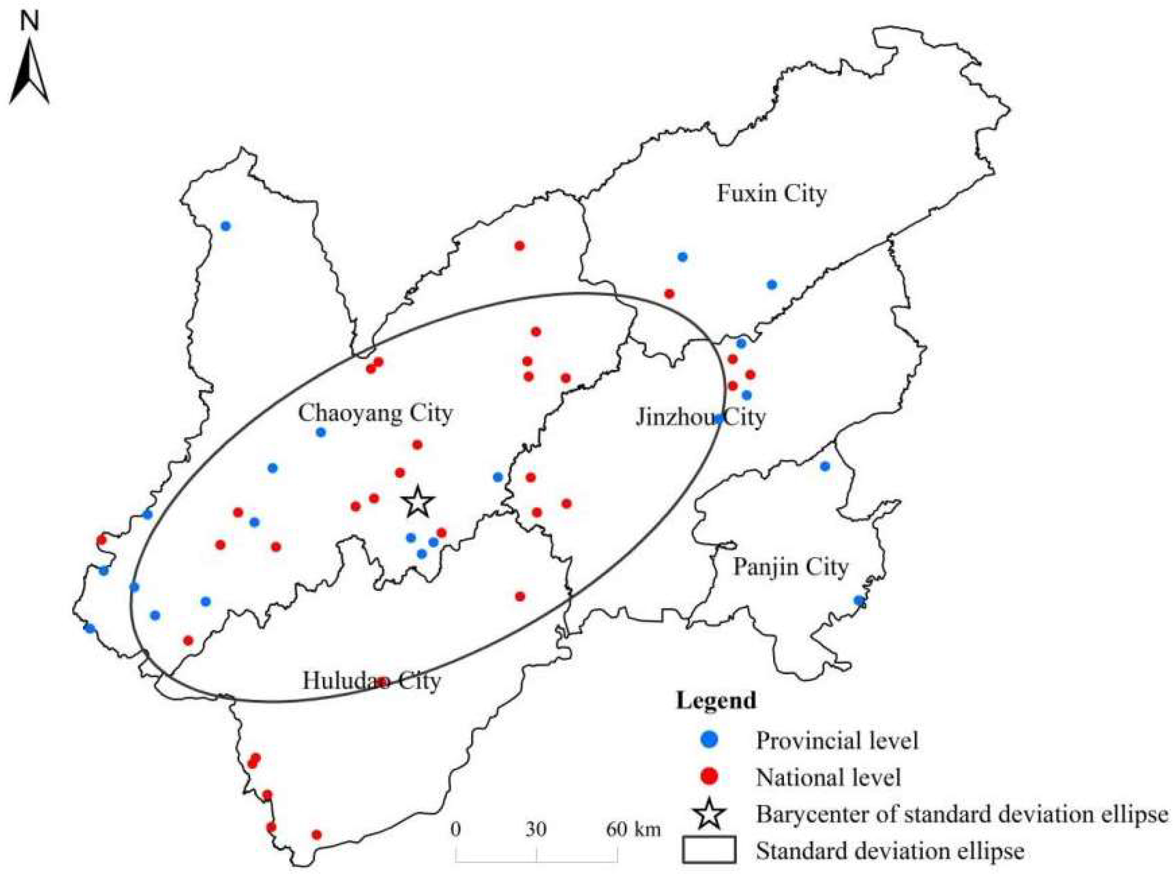
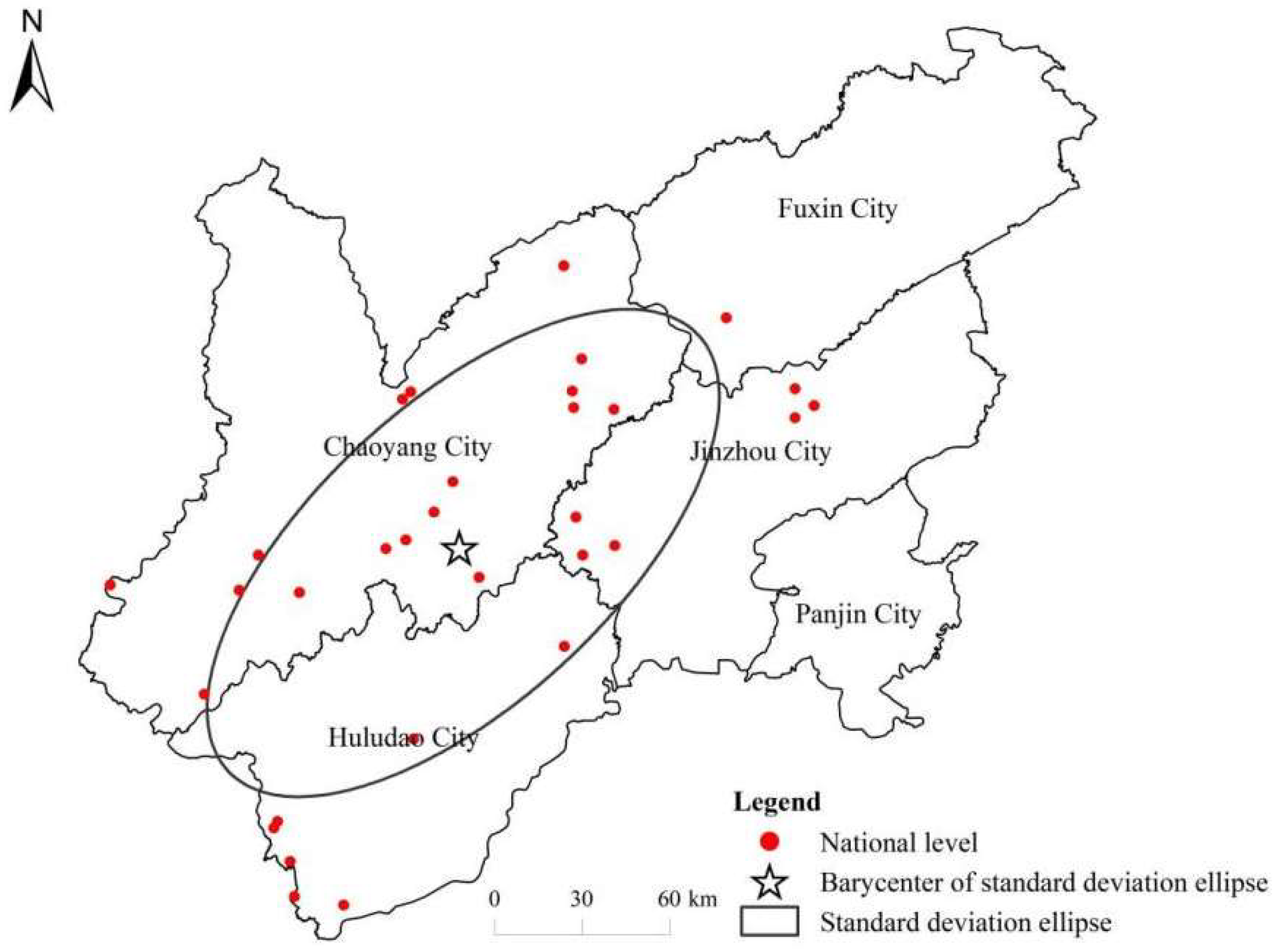
2.3.2. Standard Deviation Ellipses

The standard deviation ellipse is a spatial statistical tool that is widely used to characterize the distribution pattern of point features, such as traditional villages. The fields in Table 3 listed in the table provide quantitative measures of the spatial dispersion and directional trend of the point dataset:
  • CenterX and CenterY represent the geographic centroid coordinates (longitude and latitude or projected coordinates) of the distribution.
  • XStdDist and YStdDist measure the spatial dispersion along the major (long) and minor (short) axes of the ellipse, respectively, where larger values indicate greater spread.
  • Rotation specifies the orientation angle of the ellipse’s major axis relative to the north, indicating the predominant directional trend.
  • Shape_Length and Shape_Area quantify the ellipse’s perimeter and coverage area, reflecting the spatial extent and complexity of the distribution.
Collectively, these metrics enable a comprehensive understanding of the spatial morphology and orientation of traditional village clusters (See Table 3).

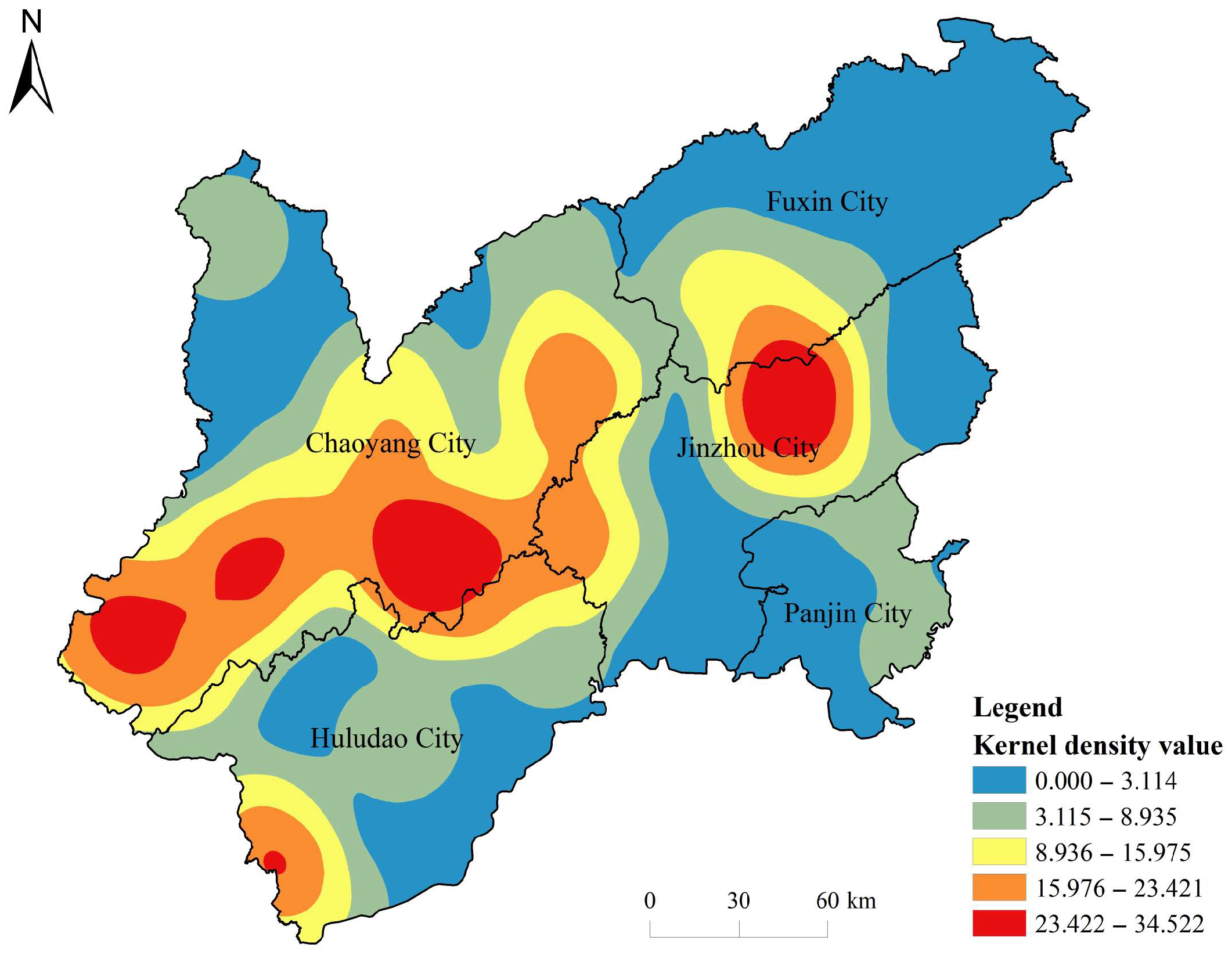
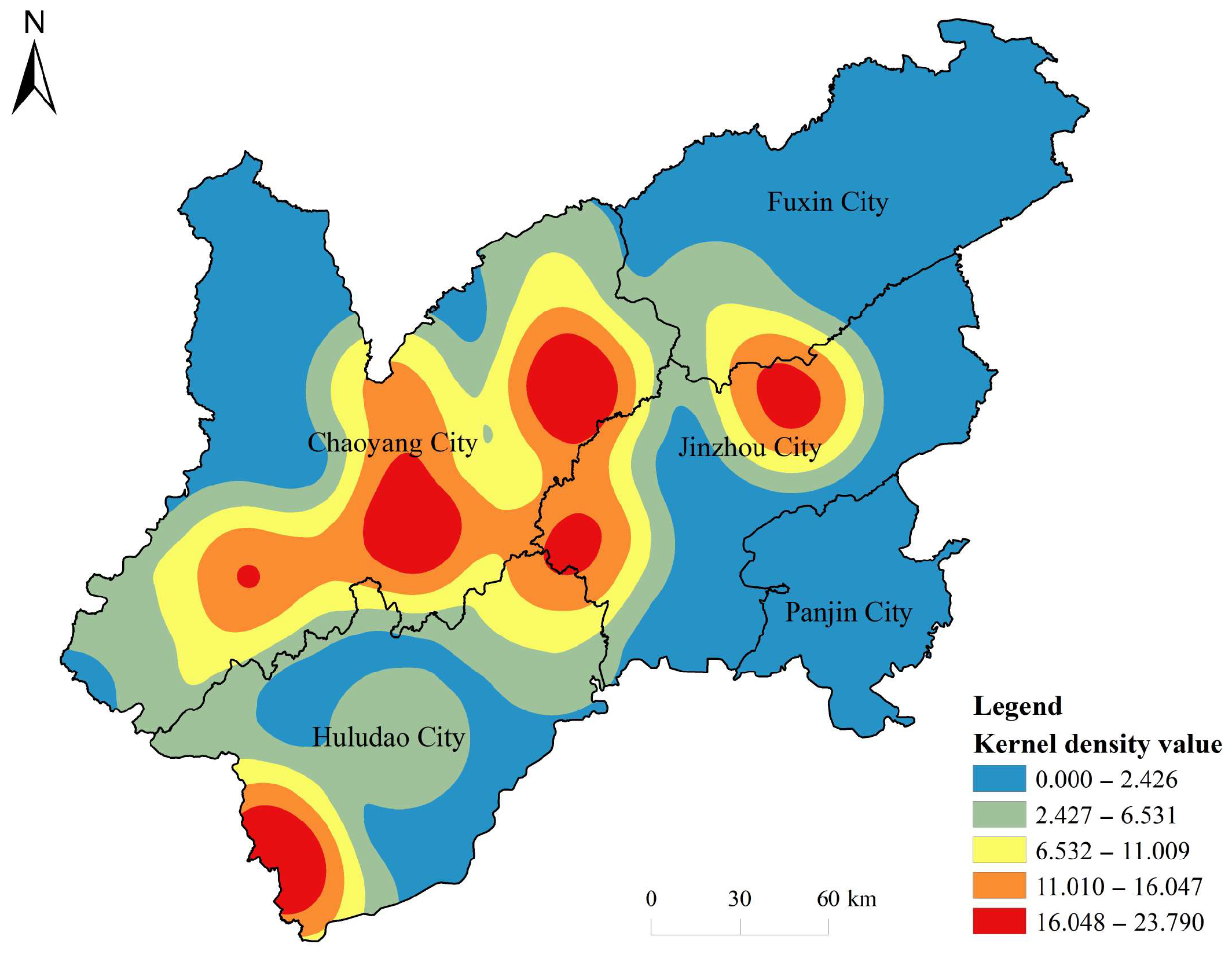
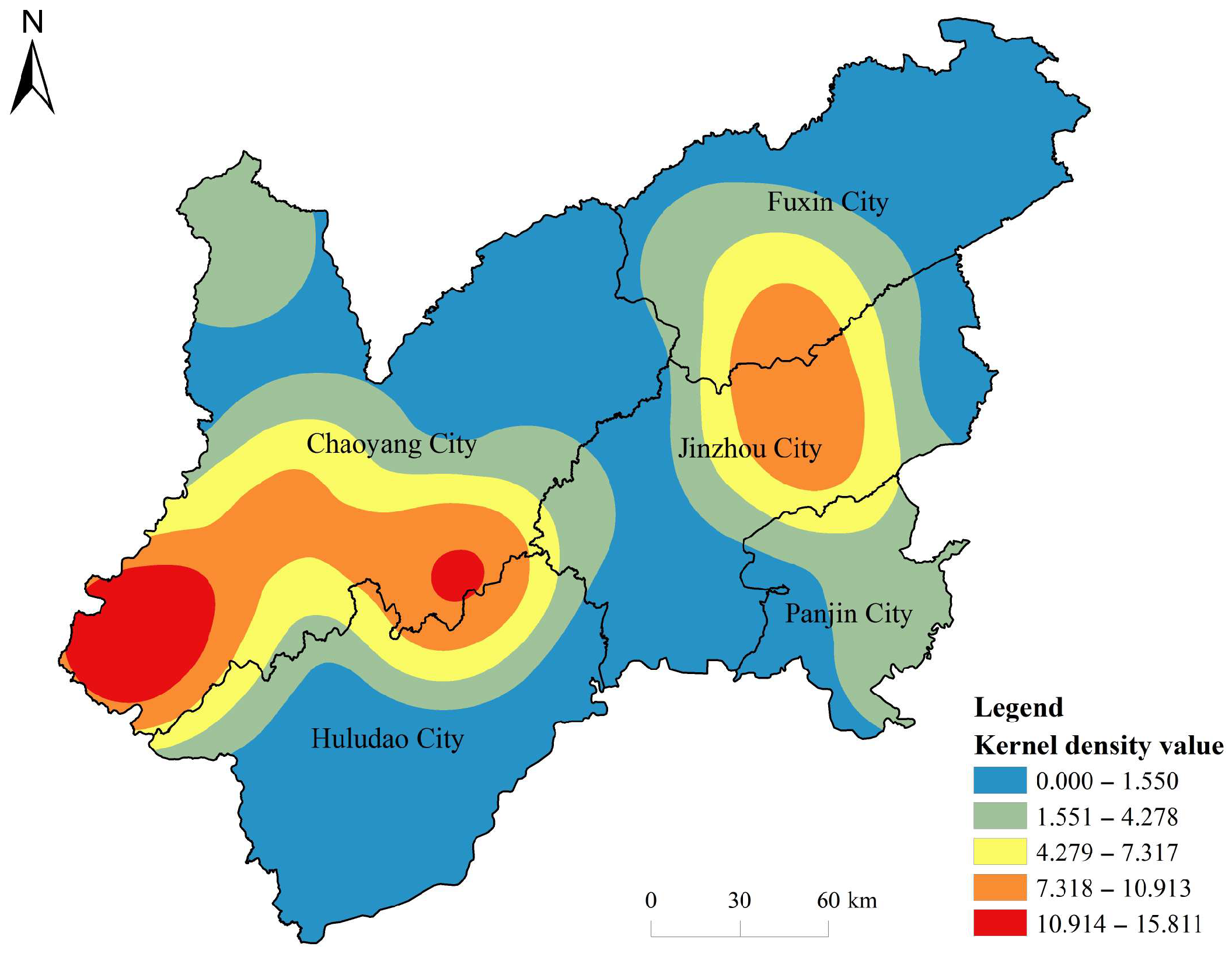
2.3.3. Kernel Density Analysis

Kernel density estimation (KDE) is a nonparametric density estimation method for estimating the density function of a spatial distribution. This method is mainly used to assess the spatial characteristics of the degree of agglomeration of traditional villages in a certain area by calculating the density of point elements in the relevant area. Its main calculation formula is as follows:
f s = i = 1 n 1 h 2 k ( s c i h )
where f(s) denotes the kernel density function, n denotes the number of points whose linear distance from point s is less than or equal to the bandwidth h, h denotes the bandwidth, and the k function denotes the distance relationship between each element point s and core point ci. The following conclusion can be drawn when the formula is applied for detailed analysis: if a certain geographic event occurs at any location in the village domain, the probability of its occurrence will differ owing to different locations. By comparison, the probability of a geographic event occurring is higher in a village area with dense point elements, and lower in a village area with sparse point elements. This method calculates the density of point elements around each grid, demonstrates the location of spatial point concentrations, and yields relevant data.

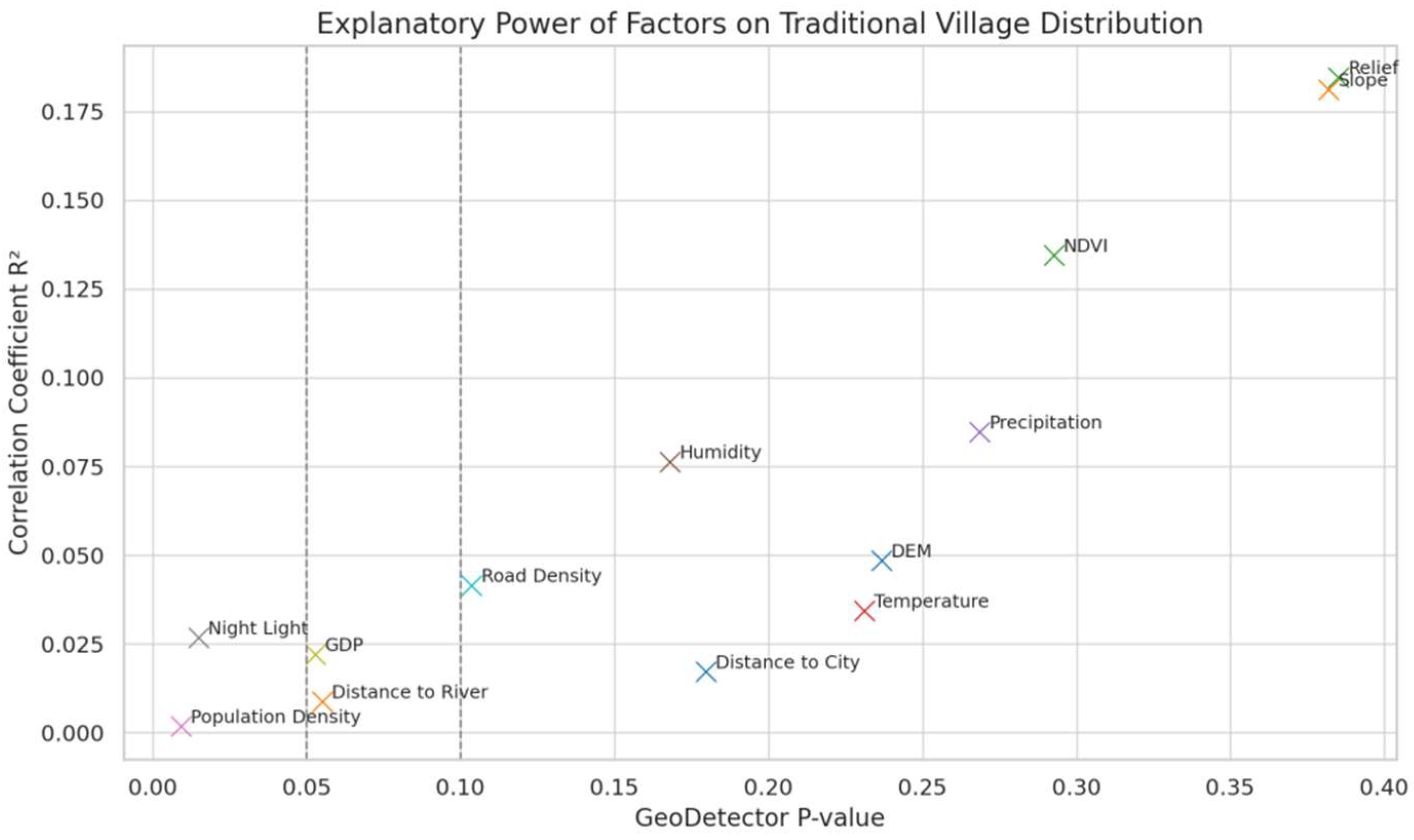
2.3.4. Geographic Detector

Figure 1 shows a scatterplot of the explanatory power of the factors influencing the spatial distribution of traditional villages in the Liaoxi Corridor. The horizontal axis represents the p-value (significance level) output by the Geodetector, and the vertical axis represents the correlation coefficient R (the square of which is the coefficient of determination R2, which is used to measure the explanatory power of each factor on the dependent variable). Each point represents a factor and is labeled with its name (e.g., “slope,” “NDVI,” “GDP,” etc.). The gray dotted lines in the figure are commonly used significance threshold lines (p = 0.05 and p = 0.10), which are used to assist in determining whether the factors reach a statistically significant level.
From the figure, it is evident that the correlation coefficient of natural geographic factors (e.g., slope and surface undulation) is high (R ≈ 0.43), corresponding to a p-value much larger than 0.05, which indicates that it has a strong explanatory power on the distribution of traditional villages, and the R-value of climatic factors (precipitation, humidity, etc.) is not too low, which is of some influence. In contrast, socioeconomic factors (population density, night lighting, GDP, road network density, etc.) have weak correlations (R-values close to 0 or negative) and mostly p < 0.05, indicating that their explanatory power is not significant. Overall, slope and surface undulation have the largest R2 values and the most significant influence on the spatial pattern of traditional villages, followed by NDVI and humidity, which is in line with the rule that the larger the R2, the stronger the explanatory power of the factors.

3. Research Results

3.1. Characteristics of Spatial Distribution of Traditional Villages in the Liaoxi Corridor

3.1.1. Types of Spatial Distribution

Figure 2 shows the spatial distribution pattern of traditional villages in the Liaoxi Corridor, covering the distribution of national and provincial traditional villages in each prefecture-level city (Chaoyang City, Jinzhou City, Huludao City, Fuxin City, and Panjin City). The distribution of villages in the cities of the Liaoxi Corridor is obviously not balanced. There are 31 traditional villages in Chaoyang City, accounting for 59.6% of the total, 9 (17.3%) in Jinzhou City, 7 (13.5%) in Huludao City, 3 (5.8%) in Fuxin City, and only 2 (3.8%) in Panjin City. As a whole, traditional villages show obvious spatial agglomeration characteristics, and there is a hierarchical differentiation and geographical imbalance in their distribution. The national-level traditional villages (red points) are more densely distributed in the study area, especially in Chaoyang City and Jinzhou City, forming a more obvious agglomeration zone, whereas the provincial-level traditional villages (blue points) are relatively dispersed and are more often distributed at the edges and in areas with complex topography and relatively inconvenient transportation.
Further observation reveals that the spatial distribution of villages is closely related to the natural geographic environment and historical and cultural development of the region. For example, in Chaoyang City, owing to its relatively flat topography and long history of farming, not only are there a large number of traditional villages in the region, but the proportion of national villages is also significantly higher than that of other municipalities. In contrast, the distribution of traditional villages in Fuxin City and Panjin City is characterized by point-like islands with weak spatial connections owing to different natural conditions or recent development intensity. Overall, the spatial distribution of national and provincial villages is characterized by a “core-periphery” pattern on the geographic scale, which also reflects the complexity of the coupling of natural and humanistic elements within the region.

3.1.2. Balanced Spatial Distribution

Based on the results of the nearest-neighbor index analysis (Table 4), the spatial distribution of traditional villages in the Liaoxi Corridor shows aggregation characteristics. Specifically, the average observed distance of the overall traditional villages is 15.136 km, and the theoretical average distance is 17.374 km, corresponding to the nearest-neighbor index R = 0.871 (<1), which is significantly lower than the critical value of the random distribution, indicating that the villages have obvious spatial aggregation and are in a state of non-equilibrium distribution.
Further comparisons revealed that there are differences in the spatial organization of traditional villages of different grades (see Table 4): R = 0.989 for national villages, which is close to random distribution, indicating that their sites are more focused on cultural representativeness and balanced distribution, and their spatial agglomeration is not significant, and R = 1.076 for provincial villages, which is larger than 1, showing a certain degree of dispersion, indicating that their distribution is more dispersed geographically and that they may be affected by geographic barriers or historical migration paths.
On the whole, the spatial distribution of traditional villages in the Liaoxi Corridor is not uniform but is characterized by the spatial pattern of “clustering but uneven” and “point-like clustering” owing to the joint effects of natural topography, cultural corridors, historical development, and policy screening mechanisms. Particularly, in areas with suitable terrain and convenient transportation, the distribution of villages is more intensive, whereas villages in marginal areas are sparsely distributed. This spatial imbalance provides a basis for subsequent regional classification protection and spatial optimization planning.

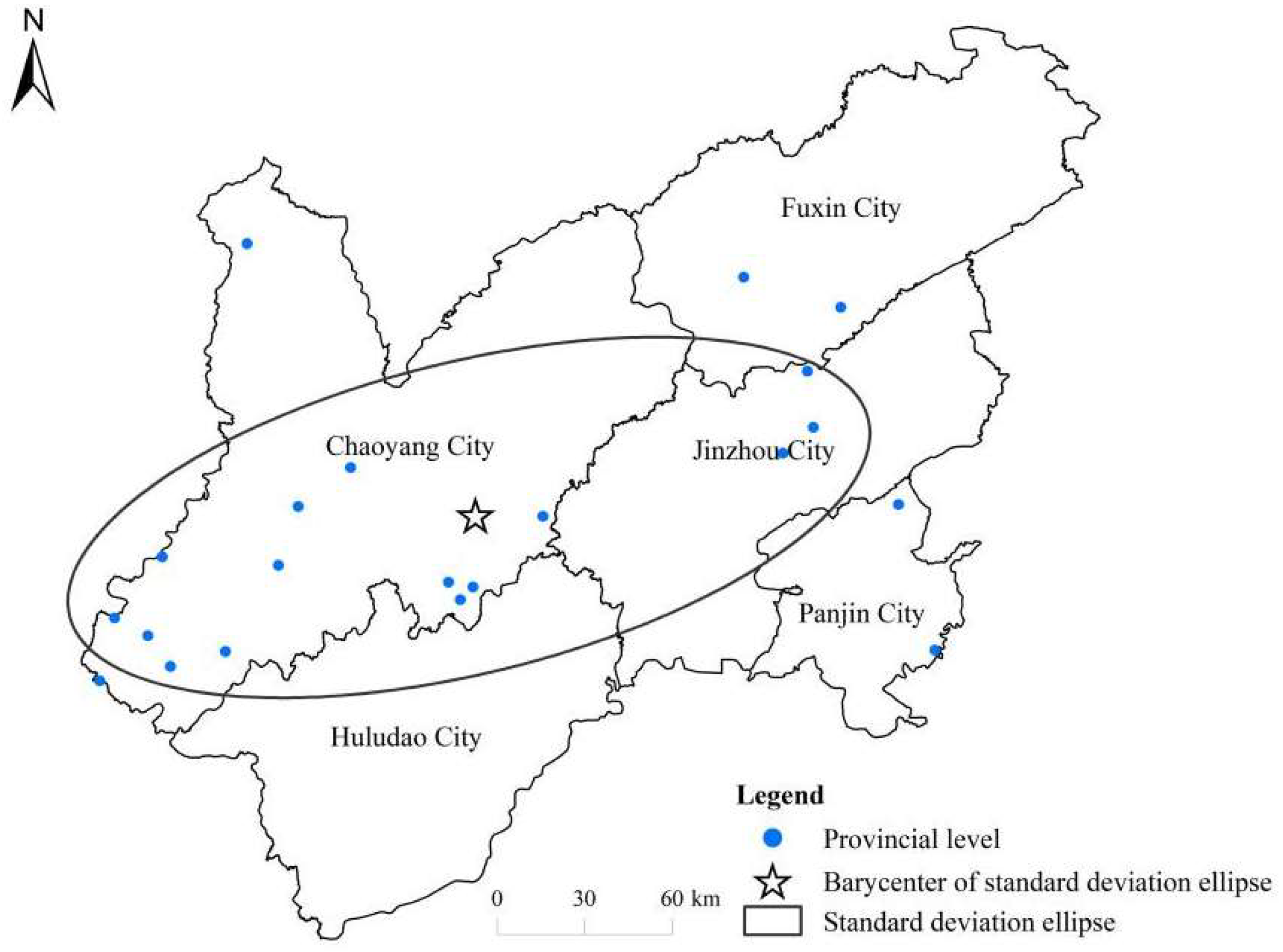
3.1.3. Directionality of Spatial Distribution

The results of the standard deviation ellipse analysis show that the overall distribution center of traditional villages in the Liaoxi Corridor is located at 120.39° E longitude and 41.23° N latitude (Table 5), with the main axis azimuth of approximately 63° and oriented in a northeast–southwest direction. The long axis of the ellipse of national villages is 109.91 km, azimuth 47°, and provincial villages 140.79 km, azimuth 76°, indicating that the spatial distribution of provincial villages is wider and extended (Table 5).
The standard deviation ellipse of the overall village distribution (Figure 3) reveals the center position and main axis direction of the village spatial layout. The standard deviation ellipse of the overall village distribution shows an obvious elongated pattern in the southwest–northeast direction, indicating that the villages are distributed in a belt-like manner along this direction. The center of the ellipse (center of gravity) is located in the southern part of the study area, slightly to the south, and close to the main village gathering area, indicating that the terrain in this zone is relatively flat, with better resource conditions, and it is the geometric center of gravity of the village layout in the entire area. The long axis of the ellipse is significantly larger than the short axis, which means that compared with the vertical direction, the distribution of villages in the direction of the main axis is more dispersed and extended, and the spatial pattern has obvious anisotropy. Summarizing the above features, it can be inferred that the distribution pattern is not accidental but is the result of the joint action of a variety of factors. For example, Wang et al. [21] found that rural settlements in a mountainous area were distributed in a strip along the main transportation arteries and mainly concentrated in the southern and central flat areas with lower elevations. This suggests that the topographic water system and road skeleton are likely to extend along the southwest–northeast direction, and villages are distributed along river valleys or basins with smaller slopes and abundant available land. Concomitantly, natural environmental factors, such as topography (elevation and slope), play a fundamental role in the location of villages [22], and human and social factors (e.g., traditional ethnic settlement practices) and policy factors (e.g., rural revitalization planning or relocation for poverty alleviation) may also reinforce the spatial pattern of forming lines along major access roads. In other words, the natural environment is the cornerstone of the spatial structure of villages, humanistic culture is the internal driver, and planning policy is the external motivation, which together shape the southwest–northeast distribution pattern of villages in the region [21,22].
This linear directional spatial pattern provides important insights into rural planning and governance. First, in terms of infrastructure and resource allocation, the layout should follow the direction of village belt distribution: infrastructure such as main transportation roads, water supply, and electricity can be centrally configured along the southwest–northeast axis, while east–west lateral roads and public transportation can be strengthened to improve the accessibility and connectivity of villages at both ends of the belt region. Second, the service imbalance caused by linear distribution should be avoided in terms of public service equalization. Li et al. [23] pointed out that rural public spaces function as “critical carriers within the rural spatial system” and can be categorized as explicit and implicit types. For example, tiered medical service centers can be set up in major settlement zones, and grassroots clinics can be evenly distributed in remote villages, educational resources can be dispersed in each village, while high-level schools can be provided in central villages, and cultural and recreational facilities can be centralized in dense areas of villages to balance the benefits of parity and agglomeration. Finally, in terms of cultural heritage protection, linear distribution brings both the opportunity of centralized protection and challenge of decentralized protection. If there are traditional villages and other cultural resources in the study area, a cultural tourism corridor can be built along the southwest–northeast axis to implement continuous protection or overall development of villages gathered along the line; simultaneously, attention needs to be paid to scattered villages in non-axis areas. As Wu et al. [24] noted, a comprehensive understanding of the spatiotemporal patterns of traditional villages on multiple scales has important significance in protecting traditional culture, revitalizing traditional villages and achieving sustainable urbanization.
The standard deviation ellipse of the distribution of national-level villages (Figure 4, Table 5) shows a clear pattern of aggregation. Although the direction of the ellipse is in the same southwest–northeast direction as the overall villages, the area is smaller and less discrete, and the center of the ellipse is also obviously biased toward regions such as Jinzhou, indicating that the spatial center of gravity of the national villages does not completely overlap with that of the overall villages. Some studies have pointed out that villages in China generally show a distribution pattern of more in the east and less in the west [25]. This pattern is formed by a variety of factors: (1) topography, whereby national-level traditional villages are mostly distributed in river floodplains and low mountainous and hilly belts, which is conducive to the formation of contiguous villages (in contrast to the western high mountainous areas), (2) transportation, where it is easier to form a settlement belt along the areas with convenient transportation, and (3) economic and cultural resources, where it is easier to produce national-level villages in areas that are more economically developed and have rich cultural heritage [26]. In addition, the selection criteria for the national-level village list are strict, and the number of villages selected is limited; hence, the local governments are more inclined to focus on the promotion and protection of existing representative villages (e.g., around Jinzhou), exacerbating spatial concentration. Overall, the distribution of national-level villages has directional characteristics consistent with the general distribution but is more concentrated and limited. This concentration pattern has important implications for village planning: key agglomerations require greater investment in infrastructure and public services, while the surrounding remote areas may be neglected, leading to uneven spatial services [27]. In terms of cultural heritage protection, the centralized distribution of national villages makes unified planning and cluster utilization possible, but it also reminds administrators to be alert to the protection blind spots brought about by “shifting the center of gravity” and consider the protection strategies for the neighboring villages that are not yet included in the list [28,29].
The standard deviation ellipse of the provincial village distribution (Figure 5, Table 5) reflects a wider coverage and similar directional trend. The standard deviation ellipse of provincial villages covers a larger area, has a longer axis, and extends in a southwest–northeast direction. Its center of gravity is basically the same as the center of the overall distribution of villages, which indicates that provincial villages generally cover the main agglomeration areas. Compared with national villages, provincial villages are more numerous and slightly more scattered, usually located between economic centers, plains, and hills. This is influenced by natural, economic, and social conditions. For example, major river valleys and plains tend to gather a large number of villages, and cities and counties have the incentive to declare provincial villages, resulting in a spatial distribution that generally matches the population and transportation network [26,29]. Thus, provincial village distribution reflects both directional aggregation and wider geographical coverage. In rural planning, this means a balanced allocation of infrastructure and public services over a wider area, consolidating service provision to the main agglomeration areas, and extending coverage to decentralized areas to avoid unbalanced development between regions. In terms of cultural heritage protection, owing to the large number of villages at the provincial level and their wide distribution, it is necessary to adopt a combination of “centralized and decentralized” strategies: regional protection and linked development can be implemented in the dense areas of villages, whereas differentiated protection plans should be formulated for scattered villages to ensure the fairness and comprehensiveness of cultural heritage protection [30].

3.1.4. Spatial Distribution Clustering Characteristics

Here, we use the kernel density analysis function in the spatial analysis tool of ArcGIS 10.1 to analyze the kernel density of 52 traditional villages and generate a kernel density distribution map of the Liaoxi Corridor (Figure 6). Figure 3 shows that the traditional villages in the Liaoxi Corridor are mainly concentrated in two high-density regions: Chaoyang County and Beizhen City. The Daqingshan Mountain Range in the north of Chaoyang County has peaks over 1000 m above sea level, and the main peak is approximately 1153 m above sea level. The Medical Wululu Mountain Range, where Beizhen City is located, is one of the five major Zhenshan mountains in China. The region is relatively undeveloped in terms of transportation, and the economic development of mountainous areas is limited; however, to a certain extent, it provides favorable conditions for the formation and development of traditional villages, reduces the interference and influence of the outside world on traditional villages, and helps protect their integrity.
Beipiao City and Kazuo County also form a sub-high-density area. Beipiao City is the hometown of Chinese folk art, and its folk tales are listed on the national intangible cultural heritage protection list. Kazuo County, known as the “Township of the Golden Tripod,” is a typical Mongolian autonomous county, with the Mongolian population accounting for approximately one-fifth of the county’s total population. These profound historical and cultural deposits provide a good foundation for the protection of traditional villages. The overall village kernel density map (Figure 6) reveals the degree of concentration in the distribution of villages through smoothing estimation, highlighting the hotspots of high-density villages in the region. Areas of high kernel density are shown in warm colors, mainly concentrated in the radial belt of Jinzhou City and local areas in the southwest (Figure 7), indicating that villages are extremely concentrated in these places, with densities much higher than the regional average. In contrast, the values of kernel density in the northwest and part of the eastern part of Liaoning are close to zero (cold colors), indicating that there are almost no villages present. This kernel density pattern quantitatively verifies the highly aggregated nature of village distribution: only a few regions form significant aggregation centers, whereas most regions have extremely low village densities. This indicates a clear spatial differentiation and aggregation characteristics in the distribution of villages. This spatial agglomeration not only stems from natural geographic conditions (e.g., mountainous terrain blocks foreign development and reduces the intensity of modernization) but also reflects the settlement pattern shaped by historical transportation corridors and multi-ethnic cultural exchanges [27]. Highly clustered village areas tend to retain a more complete spatial texture and cultural traditions, contributing to the formation of stable clan networks, handcraft inheritance, and folk belief systems, which are important carriers of regional cultural heritage preservation [31]. However, this spatial differentiation also brings obvious spatial equity problems: although high-density clusters have conservation potential, the pressure of resource competition and tourism development may lead to overconcentration, while low-density areas are often neglected owing to the lack of a scale effect and are faced with the dual challenges of insufficient conservation funding and backwardness of infrastructure [32]. This hotspot–coldspot pattern (Figure 7) reflects an imbalance in the distribution of rural planning and public services, which calls for the development of stratified infrastructure and protection strategies in future spatial planning to ensure that all types of traditional villages receive appropriate development support and promote the coordinated development of urban and rural areas [33].
The distribution of kernel densities of national-level villages (e.g., national model villages) further highlights the preferential nature of village clustering. Owing to the small number of national-level villages, their kernel density maps show more concentrated hotspot areas: the highest densities are concentrated in a few core areas (e.g., around Jinzhou, near Chaoyang, or on the southwestern edge), which have become the main aggregation centers of national-level villages. In most areas, the kernel density of national-level villages is close to zero, indicating that national-level villages are almost nonexistent, except in these hotspot areas. The higher spatial concentration of national villages and the more limited number of hotspots compared to the overall kernel density reflect the unevenness of resources or policy investment within the geographic area—national villages tend to be located in specific areas of dominance. This highly concentrated “center-periphery” distribution pattern reflects the priority and selectivity of national-level conservation resources [27]. On one hand, centralized protection can form a scale effect, which is convenient for unified planning, centralized investment, and promotion of heritage tourism development; on the other hand, it may also exacerbate the shortcomings of cultural heritage protection in the peripheral areas, which makes a large number of villages that are not selected for the national list fall into the predicament of “protection island” [34]. From the perspective of cultural heritage management, this spatial imbalance is not only the inevitable result of the centralized utilization of resources but also exposes the limitations of national-level list protection in terms of coverage [35]. The tilting of high-level protection resources and policies to limited areas may lead to the continued marginalization of traditional cultural spaces in non-hotspots. To alleviate this spatial imbalance, multilevel and multibody cooperation should be encouraged to support the protection of villages outside the national-level list through local policy subsidies and the construction of cultural corridors to avoid cultural memory rupture owing to the differences in administrative levels [36].
The distribution of kernel densities in provincial villages (Figure 8) shows a broader but still highly heterogeneous pattern compared to that in national villages. Provincial villages are more numerous, and their kernel density maps show a large high-density area in the southwest, which has one of the highest kernel density values in the region, and a sub-high-density agglomeration in the Jinzhou-Chaoyang area. However, despite the expanded coverage, there are still large areas of low density (blue), indicating that provincial villages are sparsely distributed in many places. Overall, the kernel densities of provincial villages reveal that villages form multiple agglomerations over a wider area, but the problem of uneven distribution remains prominent. Provincial villages are slightly more spatially dispersed than national villages, but their main aggregation trends are consistent with the overall distribution and remain concentrated in dominant locations. Provincial lists have included more villages with local values into the protection system, making up for the lack of a national-level protection scope and forming several decentralized sub-high-density areas [27,37]. This shows the role of the provincial level in the protection of traditional villages, which helps establish a multicenter and multinode heritage network on a larger spatial scale and improve the resilience of the overall cultural heritage system [38].
However, the provincial level also faces the problem of uneven distribution. Some regions have a significantly lower rate of villages selected because of their different economic bases, motivation to declare, and emphasis on policies. This suggests that, in future spatial planning, it is necessary to promote spatial equity in the protection of traditional villages by upgrading the grassroots cultural preservation force, improving the declaration mechanism, and with differentiated support policies [18]. Concomitantly, provincial traditional villages can be regarded as nodes of regional cultural inheritance, and through a networked layout, centralized and continuous protection, and regional cooperation for development, they can realize the complementary use and holistic protection of traditional culture, avoiding the risk of overtourism brought about by the development of a single hotspot [2].

3.2. Analysis of Influencing Factors on the Distribution of Traditional Villages in the Liaoxi Corridor

Geographic factors are the main drivers of the spatial distribution of traditional villages, with the highest correlation for slope and surface undulation (R ≈ 0.43), and a q-value of the Geodetector close to 0.38. The NDVI is also positively correlated with the distribution of villages (R ≈ 0.367, q ≈ 0.29), while climatic factors show a weak negative correlation. The correlation coefficients of socioeconomic factors (e.g., population density and GDP) were low or even negative (|R| < 0.2, q < 0.1), suggesting that contemporary economic development has limited influence on the distribution of traditional villages.
To further determine the spatial distribution characteristics of traditional villages in the Liaoxi Corridor, this study adopts the Tyson polygon (Voronoi diagram) coefficient of variation method to study villages with an aggregated spatial distribution. Through the spatial analysis operation in ArcGIS 10.1, the mean value of the Tyson polygon area is 941.29 km2, standard deviation is 1443.82 km2, and the coefficient of variation is 153.39%, which is much larger than 79%. This indicates that the distribution of traditional villages has obvious clustering characteristics, which coincides with the analysis results of the nearest-neighbor index; that is, the traditional villages in the Liaoxi Corridor are distributed in a concentrated state.

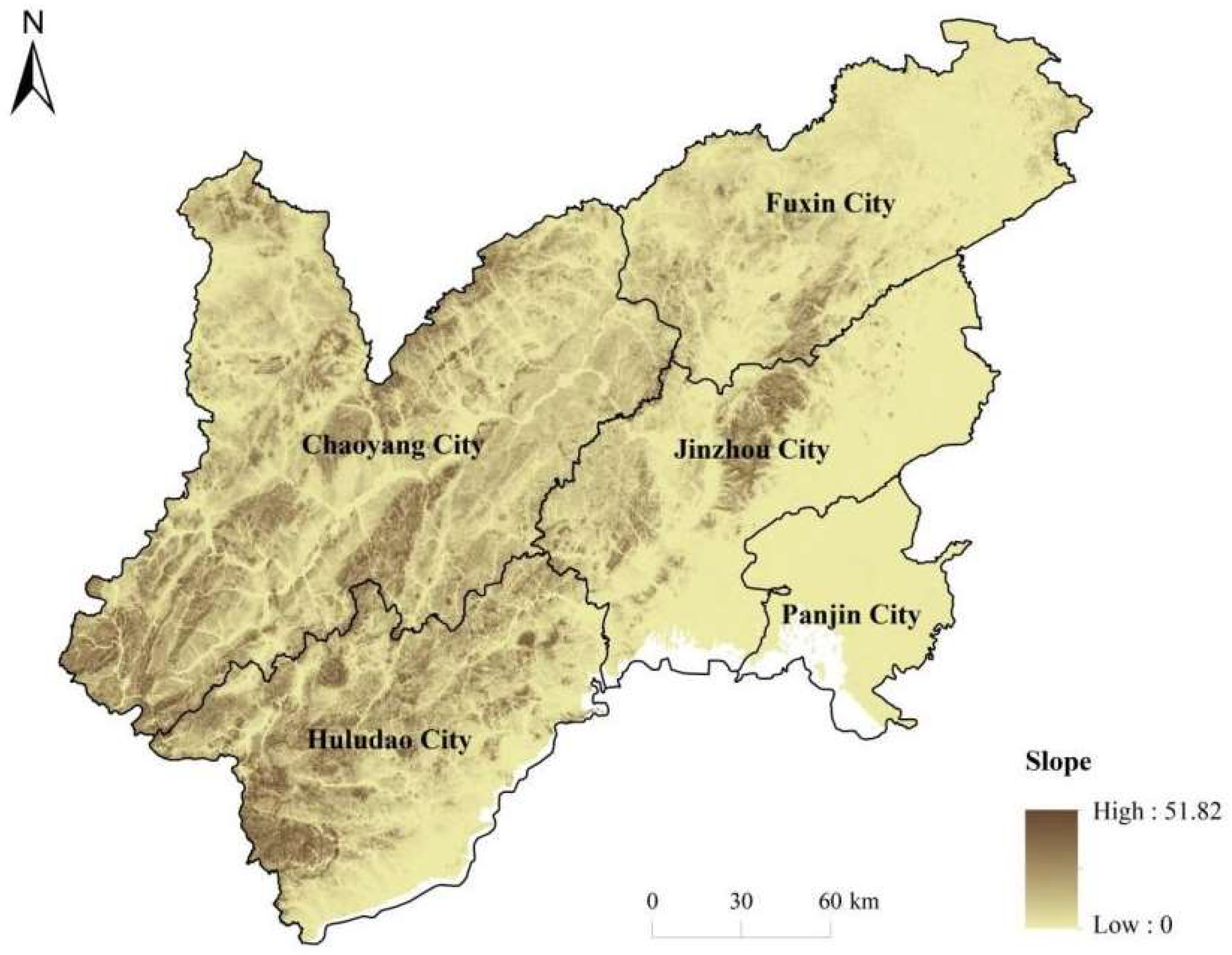
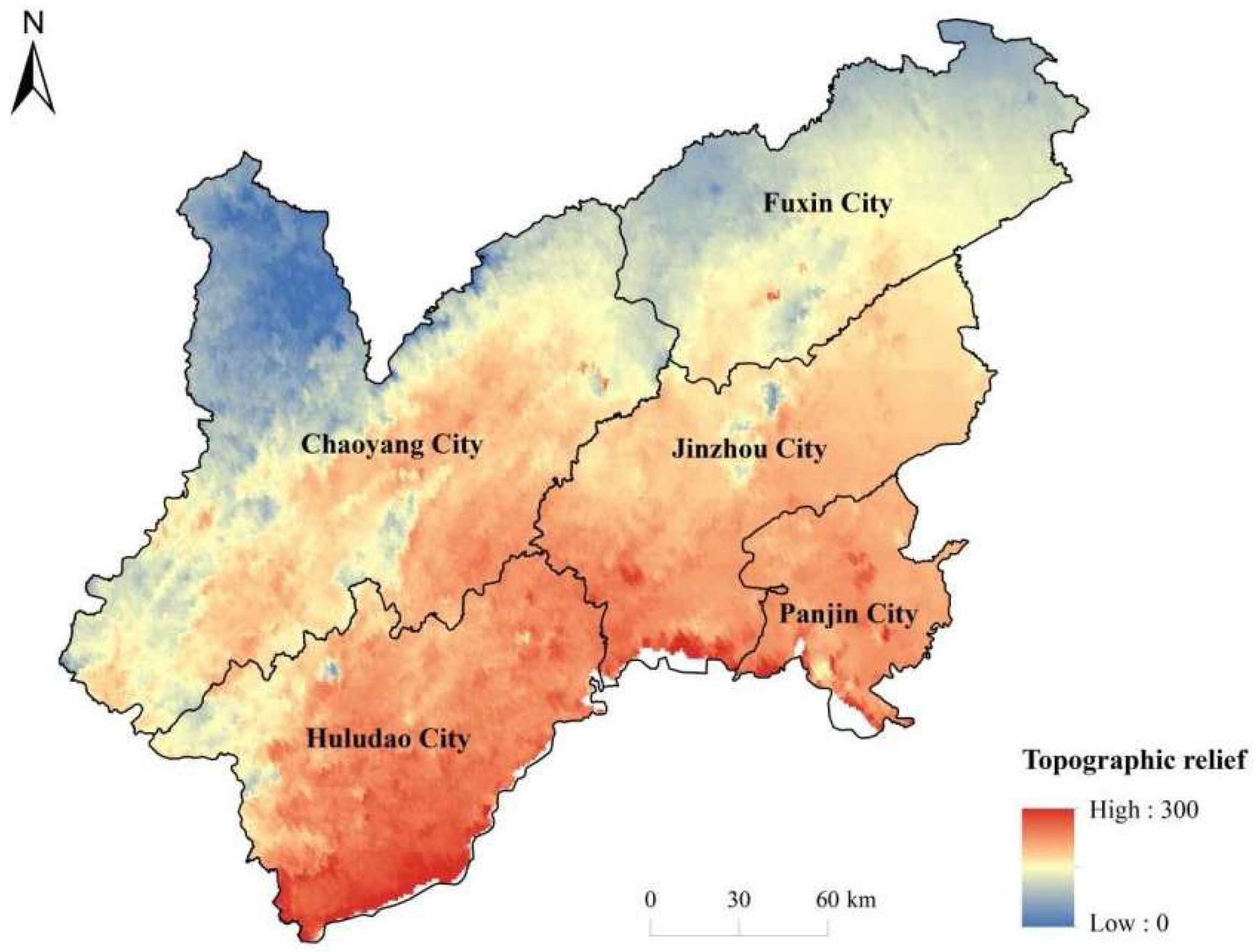
3.2.1. Topography and Geomorphology Factors

Topography is one of the key geological and environmental factors influencing the distribution of traditional villages. Elevation affects various environmental elements, such as surface water distribution patterns, temperature and humidity, biogeographical boundaries, and land type classification. It also affects the regional environment, structural form, and cultural customs shaped by the livelihood practices of local villagers.
This study is based on 30 m resolution Digital Elevation Model (DEM) data provided by the National Geospatial Data Cloud (www.gscloud.cn), combined with a 1:500,000 scale map of Liaoning Province. Based on field surveys and corrections, a spatial overlay elevation analysis of traditional villages in the Liaoxi Corridor was conducted using ArcGIS 10.1. The DEM data were reclassified using the Natural Breaks method, and the analysis results are shown in Figure 9.
The low hilly terrain of the Liaoxi Corridor provides a relatively enclosed and independent living environment for traditional villages. These topographical conditions not only facilitate the development of distinctive natural environments and folk cultures but also offer essential physical and environmental support for the protection and sustainable development of traditional villages.
Figure 9 illustrates the elevation distribution characteristics in the Liaoxi Corridor region. The geomorphology of the region generally shows a gradient pattern of low in the southeast and high in the northwest, with the elevation gradually rising from less than 50 m in the coastal low plain to approximately 1000 m in the western mountainous areas, reflecting the diverse coexistence of plains, hills, and mountains. The differences in elevation have had a profound impact on climatic conditions, land-use patterns, and the location of traditional villages. High-altitude areas have a cold climate, shorter growing periods, and poorer soils, making them more suitable for forestry or pastoralism, whereas low-altitude areas have a mild climate and fertile soils, making them more suitable for agricultural development. This vertical zonation enables villages at different altitudes to develop different livelihoods and spatial layouts [39,40]. In the Liaoxi Corridor, traditional villages are mostly located in the foothills and gentle river valleys at low and middle elevations, which can prevent the risk of flooding in low-lying areas and maintain warm and moderate climatic conditions favorable for agricultural development and human settlement [12]. The complex topography makes the high-altitude areas relatively isolated, slowing the impact of external factors on the villages and preserving more historical villages, whereas the low-altitude plain areas are conveniently accessible and rapidly developing economically, leading to the gradual replacement of traditional villages with modern towns. Therefore, elevation plays a fundamental regulatory role in village distribution [39,40]. From the perspective of rural planning, villages in high-altitude areas face the challenges of difficult infrastructure construction and lagging economic development, and the fairness of services is difficult to guarantee. However, their environmental closure also provides potential opportunities for the preservation of traditional culture and the development of a characteristic economy.
As shown in Figure 10, the slope distribution is closely related to topography, with steep slopes in the mountains and gentle slopes in the plains, and significant spatial heterogeneity. High slope values are mainly found in the hilly western mountains, where roads are difficult to access and development is limited, whereas the Liaohe Plain and other low-altitude areas have slopes close to 0° and are flat, which is conducive to the layout of agriculture and towns. In general, the slope decreases from the central mountains to the peripheral plains, and there is a negative correlation with the distribution of population and transportation, reflecting that human activities are more inclined to flat terrain areas.
The spatial heterogeneity of slopes in the Liaoxi Corridor is significant, with steep slopes in the western mountainous and hilly areas and gentler slopes in the eastern plains. Areas with steeper slopes restrict the distribution and expansion of traditional villages, constrain agricultural activities, and hinder the development of infrastructure, resulting in a pattern of dispersed and smaller settlements. In contrast, the almost flat Liaohe Plain is conducive to the dense distribution and large-scale layout of villages, which contributes to agricultural production and urbanization. The negative correlation between slope distribution, population density, and accessibility reflects the fact that human activities prefer flat areas for settlement and development. These findings emphasize that in village conservation and development, differentiated strategies should be developed according to the local topographic and ecological conditions.

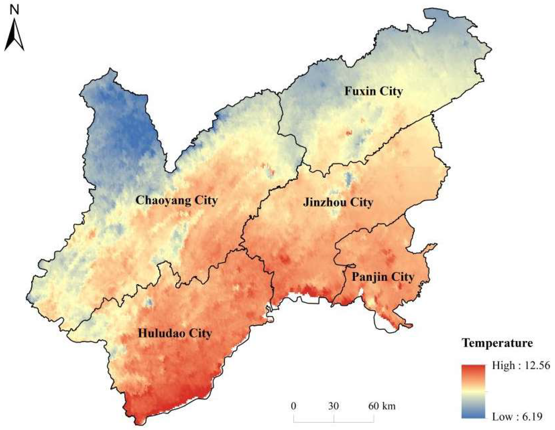
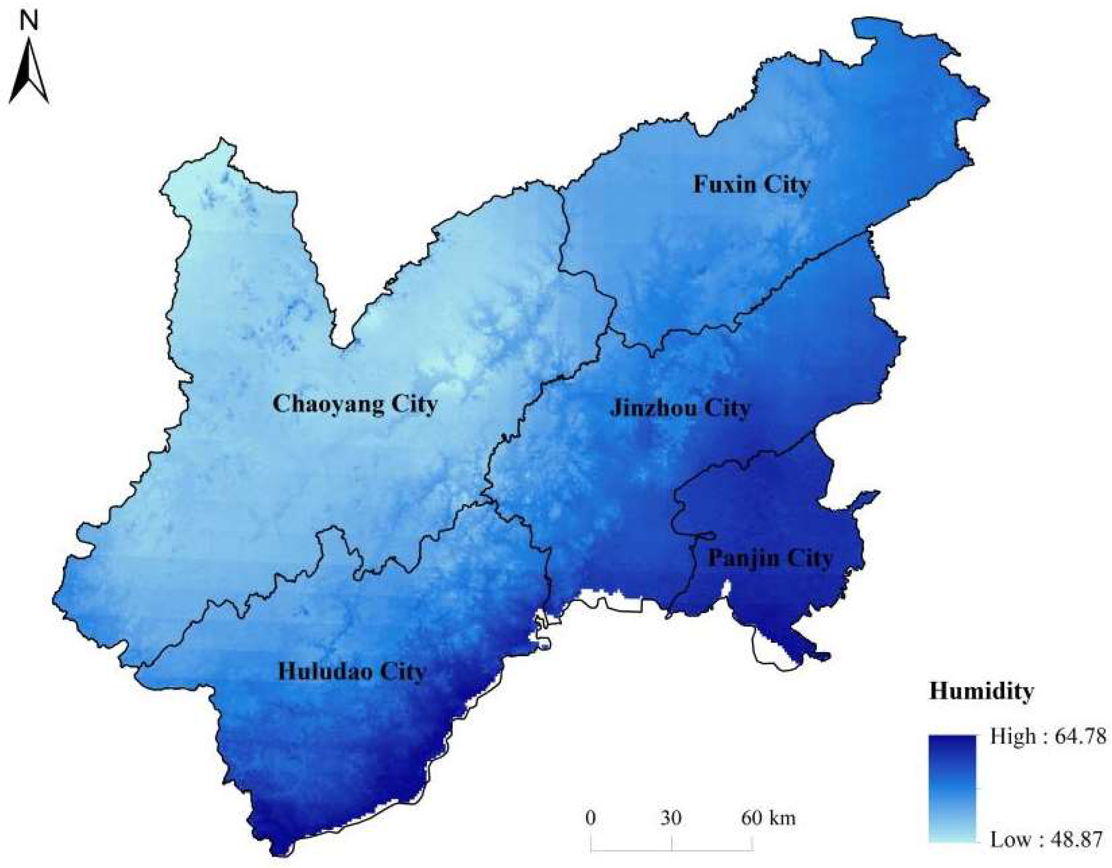
3.2.2. Climatic and Ecological Factors

As shown in Figure 11, the average annual temperature shows a decreasing spatial distribution trend from the coast to interior and from south to north. Owing to the lower latitude and oceanic regulation, the temperature is relatively high in the southern part of the coast, with an annual mean temperature of 9–10 °C. The northern inland highlands are affected by the altitude and latitude, and the temperature is relatively low, with an annual mean temperature of approximately 5 °C, and the difference between the northern and southern ends can be up to 4–5 °C. This temperature gradient reflects significant regional differences, indicating a clear spatial heterogeneity in the heat conditions between the north and south of the study area, as well as between the coast and inland.
The spatial distribution of surface undulation shows a pattern of high in the northwest and low in the southeast, which is closely related to the geomorphologic type. The topography of the high-relief area is fragmented, which is unfavorable for transportation and agricultural development, and the traditional villages are sparsely distributed with low population density, while the plain area has flat topography, dense distribution of settlements, and high intensity of land use. The degree of surface relief not only affects the spatial pattern of settlements but is also closely related to the stability of ecosystems and susceptibility to disasters. The results of this study are consistent with existing theoretical and empirical studies on the influence of topography on the distribution of settlements and provide a scientific basis for the protection and planning of traditional villages in this area.
As seen from Figure 12, the distribution of precipitation has a significant gradient, increasing from the arid northwest to the humid southeast. The inland areas in the northwest (e.g., around Chaoyang and Fuxin) have relatively low average annual precipitation of approximately 400–500 mm, reflecting semi-arid characteristics, whereas the coastal areas in the southeast (e.g., around Huludao and Panjin) are influenced by the monsoon and sea and have high annual precipitation of up to 600–700 mm. The spatial heterogeneity of precipitation is obvious, and the difference in precipitation between the north and south directly affects vegetation cover and agricultural production, reflecting the uneven distribution of water resources among regions.
The regional precipitation in the Liaoxi Corridor shows a significant spatial gradient from the northwestern inland to the southeastern coast, which gradually increases. This distribution pattern is mainly influenced by the East Asian monsoon system and topographic conditions. The northwest (e.g., Chaoyang and Fuxin) is blocked by the inland climate and topography with low average annual precipitation, and is typically a semi-arid area, whereas the southeast (e.g., Huludao and Panjin) is close to the Bohai Sea and is regulated by the oceanic climate, with a significant increase in annual precipitation. The spatial heterogeneity of precipitation not only affects the regional vegetation distribution and ecological pattern, but also directly constrains the spatial layout of agricultural production and the distribution characteristics of traditional villages. In general, the precipitation-abundant area is favorable for village agglomeration and agricultural development, whereas the arid area has sparse villages and limited production activities. In addition, the uncertainty of spatial and temporal distribution of precipitation in the context of climate change puts forward higher adaptive management requirements for regional water security and sustainable development of traditional villages.
As shown in Figure 13, the spatial distribution of relative humidity is broadly consistent with the precipitation pattern, with higher humidity in coastal and water-rich areas and lower humidity in dry inland areas. The southeastern coastal zone maintains a high level of atmospheric humidity year-round because of its proximity to Bohai Bay and wetlands (e.g., the Panjin wetlands), whereas the northwestern part of the country is far away from the ocean, with sparse precipitation, dry air, and low relative humidity. The spatial differences in humidity reflect the imbalance of regional water vapor conditions, which will affect vegetation growth and soil moisture, and are closely related to the precipitation gradient and land cover type.
The spatial distribution of relative humidity exhibits a significant gradient, decreasing from the humid zone along the southeast coast to the arid zone in the inland northwest, a pattern that is mainly influenced by the combination of regional climatic conditions, distance from marine sources, and topographic barriers. Higher air humidity in coastal and wetland areas (e.g., Panjin) is conducive to lush vegetation and fertile soil, whereas arid inland areas (e.g., Fuxin and Chaoyang) are more prone to ecological fragility and land degradation, among other phenomena. The spatial heterogeneity of humidity is closely related to precipitation patterns and land cover types and ultimately affects the suitability of traditional village settlement distribution.

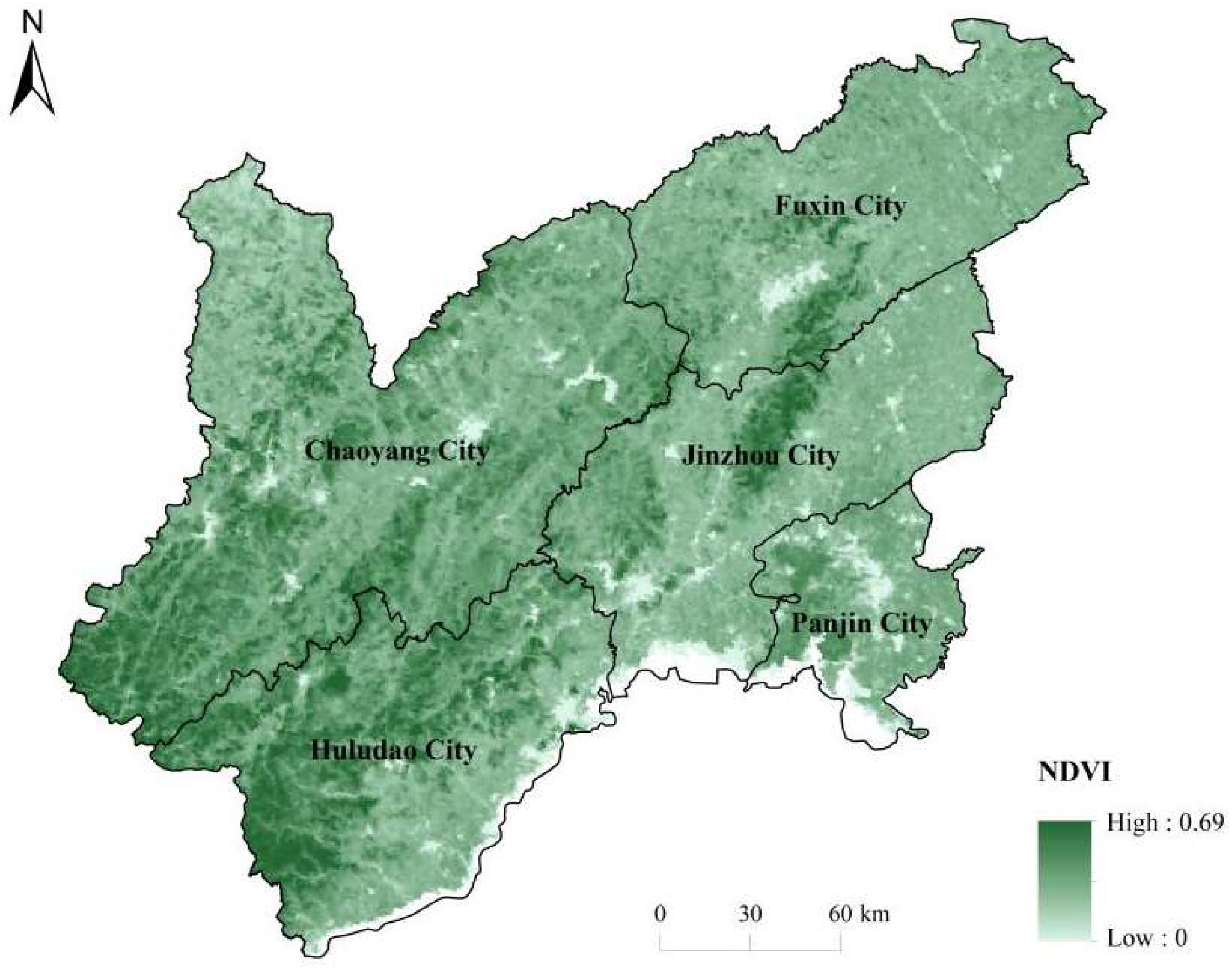
3.2.3. Environmental Factors

Normalized Difference Vegetation Index (NDVI) values range from 0 to 0.69, with obvious spatial variability in vegetation cover (Figure 14). Areas with high NDVI values (close to 0.6–0.7) are mainly distributed in areas with dense vegetation and superior hydrothermal conditions, such as the humid areas in the south or localized mountainous forests, while areas with low NDVI values (lower than 0.2) are mostly found in urban built-up areas, bare land, or arid agricultural and animal husbandry areas (e.g., areas in the northwestern part of the country where precipitation is scarce). In general, NDVI is positively correlated with precipitation and topographic conditions: areas with abundant precipitation and favorable terrain have better vegetation cover, whereas areas with strong human activities or restricted natural conditions have sparse vegetation and significant spatial heterogeneity.
The NDVI values showed significant spatial heterogeneity in the Liaoxi Corridor, with the overall distribution pattern increasing from northwest to southeast (Figure 14). High NDVI values (close to 0.6–0.7) were mainly concentrated in the southern humid zone, hilly and densely forested areas, reflecting good ecological substrates and suitable hydrothermal conditions. In contrast, in the northwestern arid zone, urban built-up areas, bare land, and part of the agricultural and pastoral zones, the NDVI values were generally lower than 0.2, and the vegetation cover was poor. The formation of the spatial pattern of NDVI is closely related to the natural factors, such as precipitation, topography, soil, and human activities. Areas with abundant precipitation, flat topography, and fertile soil tend to support a high level of vegetation cover. In contrast, human activities, such as urban expansion, industrial and mining development, and overgrazing, have led to a significant decline in NDVI in localized areas, reflecting the vulnerability of the ecosystem and the need for restoration. In addition, traditional villages are mostly distributed in areas with high NDVI, and good vegetation conditions not only enhance ecological livability but also provide a basic guarantee for the sustainable development of villages.
The distance to river indicator portrays the proximity of places to the nearest river, with values ranging from 0 to approximately 0.39, and a maximum value equivalent to approximately 40 km (Figure 15). The variable is spatially characterized by low values near the river network and high values in areas far from the river: areas along the main rivers and water systems (with distance values close to 0) form a band of low values, whereas in inland upland or basin areas far from the river network, the distance values reach high values (close to 0.3–0.4). This indicates that the water systems in the study area are unevenly distributed, and some areas are far from permanent water sources. In general, the distance from the river is negatively correlated with the degree of human settlement: areas close to rivers tend to be favorable for agriculture and settlement development, whereas areas far from water sources are sparsely populated, reflecting obvious spatial variability.
The distance from river system, as a spatial variable measuring the accessibility of the surface water system, reflects the proximity of each place in the region to major rivers or water bodies. As seen in the figure, the indicator shows a significant banded distribution pattern in space: low-value zones extend along major rivers and tributaries, indicating high water resource accessibility, whereas high-value zones are concentrated in the inland upland and basin zones away from the rivers, revealing an uneven distribution of water resources. This spatial heterogeneity not only reflects the structural characteristics of the natural hydrological network, but also profoundly affects the pattern of the regional habitat and the behavior of settlement location. The distance from rivers is highly negatively correlated with population density and agricultural land distribution. The low-value area along the river has become a dense distribution zone for traditional villages and agricultural settlements owing to the abundant water supply and fertile land, and it has high population and production activities. However, high-value areas are often ecologically fragile or have a low intensity of land use because of the lack of water and sparse distribution of settlements. In addition, the distance from the river shows a significant coupling relationship with the level of regional socioeconomic development, infrastructure layout, etc. Areas close to the water system are not only suitable for the formation of settlements, but are also convenient for transportation and material flow, which is a key belt corridor for regional development. Therefore, in the protection and spatial planning of traditional villages, great importance should be given to the ecological function of river systems and their guiding effect on the spatial pattern of settlements.

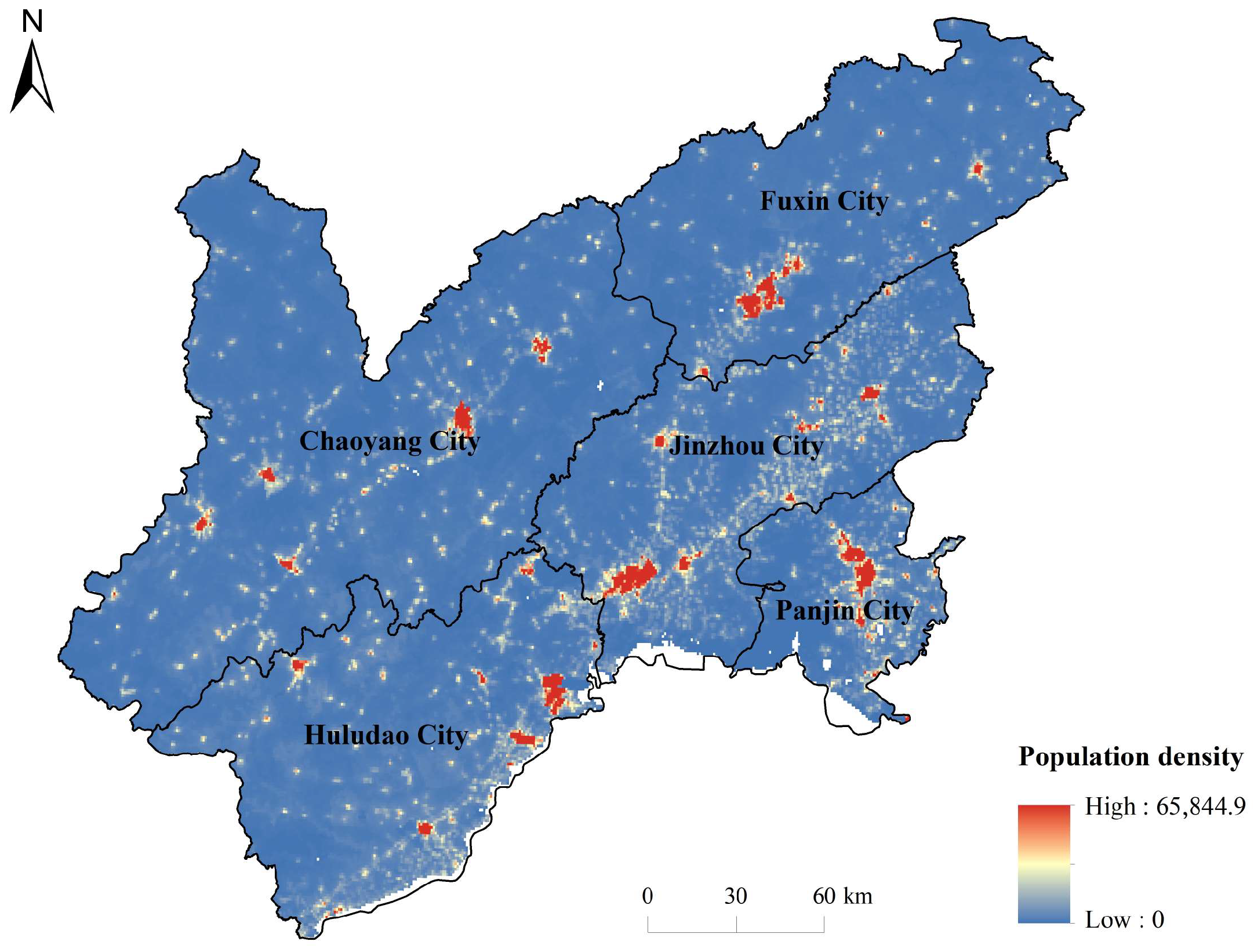
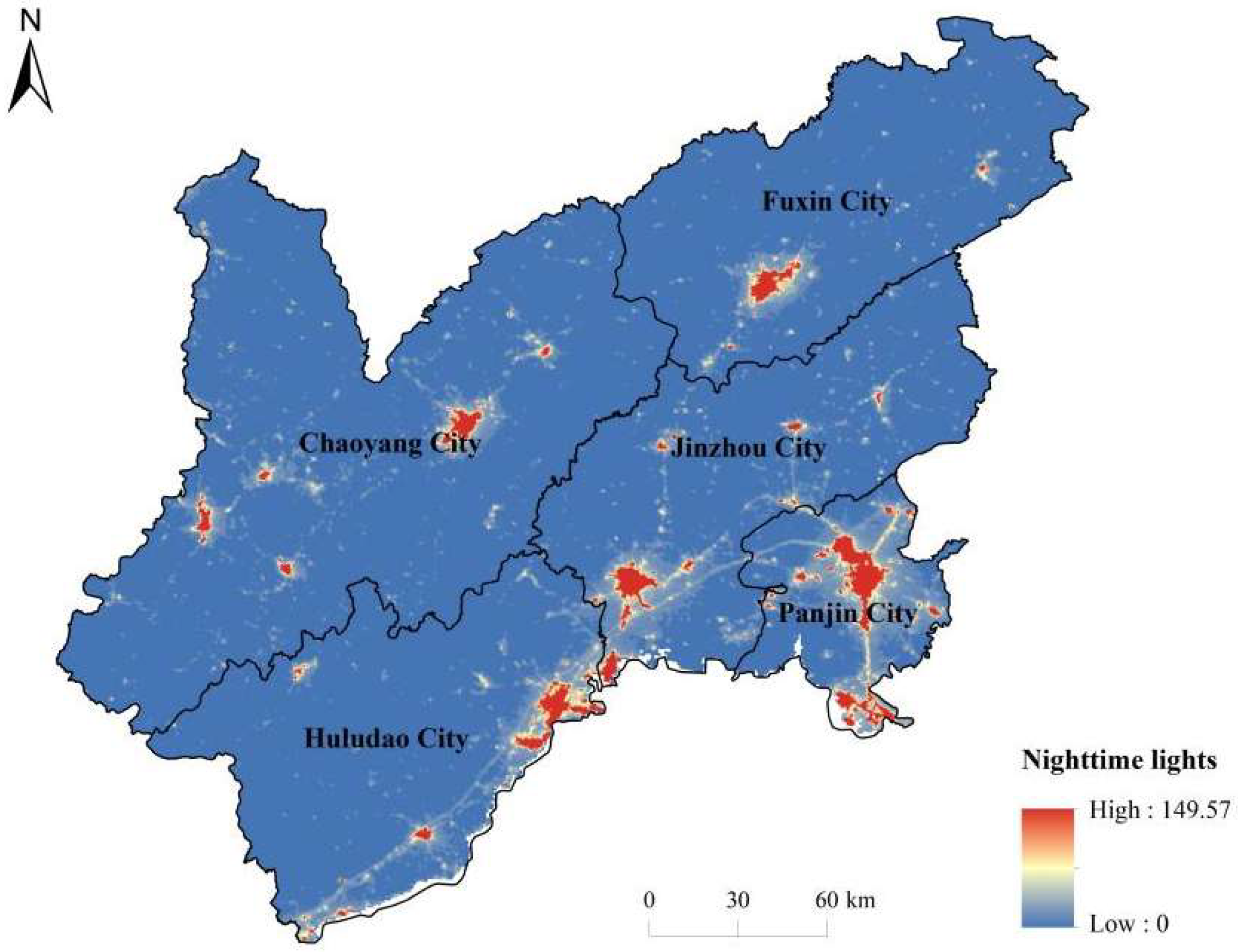
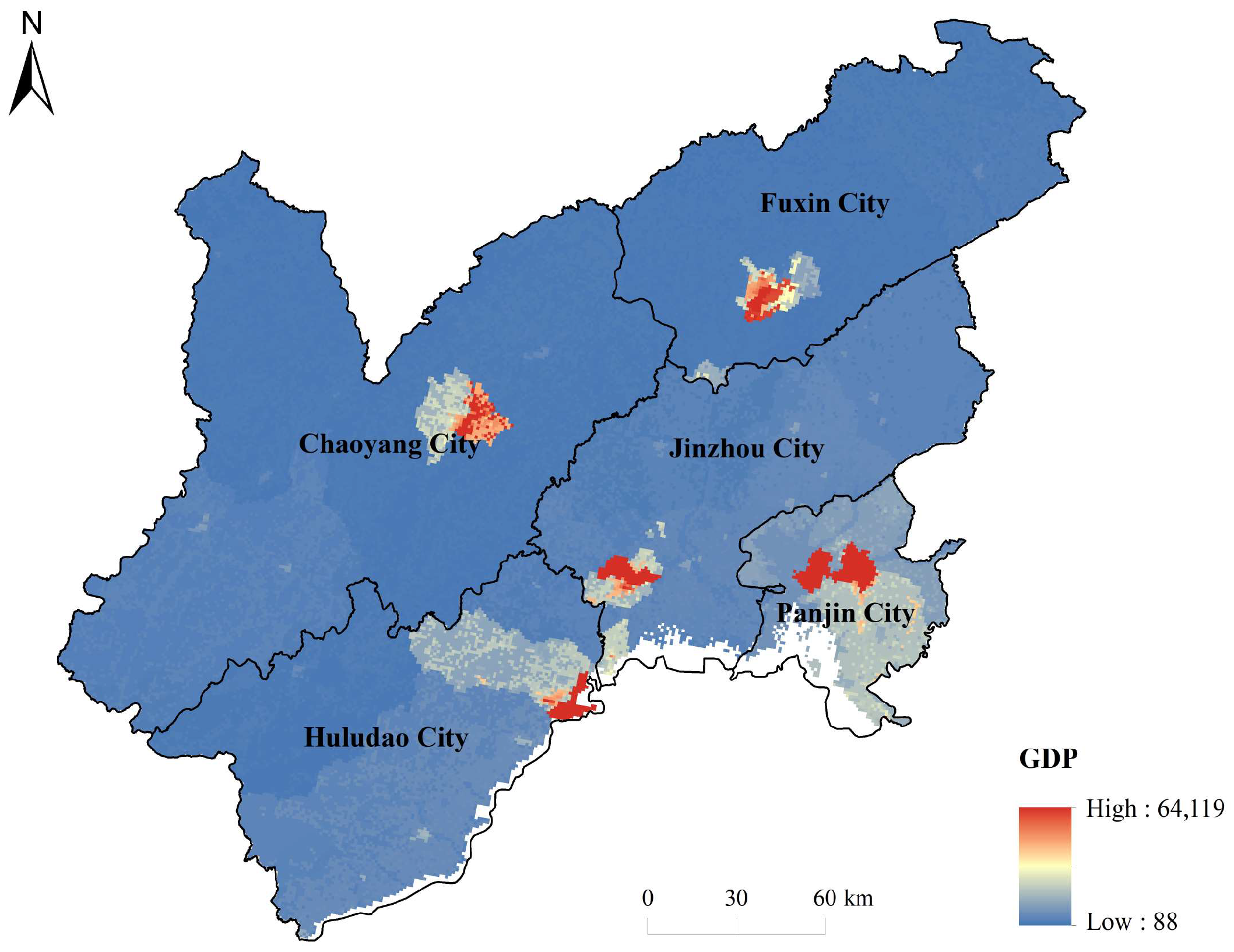
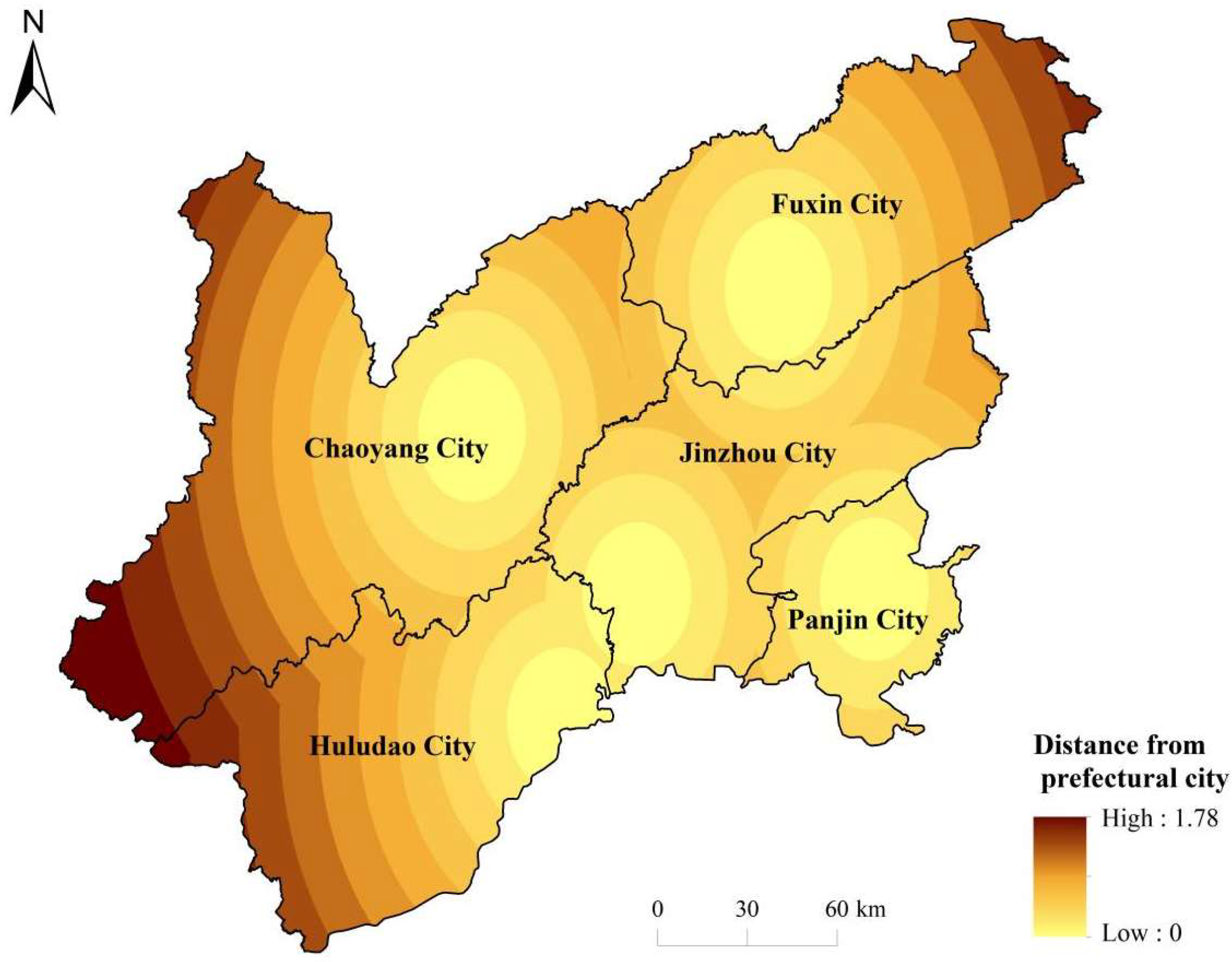
3.2.4. Population and Economic Factors

As shown in Figure 16, the distribution of population density in the Liaoxi Corridor region shows a clear dichotomy between urban agglomeration and rural hollowing out. In recent years, the rural population has continued to migrate to cities and towns, leading to the intensification of the phenomenon of “hollowing out” of the countryside, and the depopulation and gradual shrinkage of many traditional villages [31]. Population decline has made it difficult to maintain public service facilities (schools, medical services, etc.) in rural areas, further reducing the accessibility of services and exacerbating the spatial inequality between urban and rural areas [32]. This spatial distribution pattern of population has profoundly affected the allocation efficiency of resources and infrastructure construction, forming a negative cycle of “population–service.” To cope with the hollowing out of villages, the government has implemented the strategy of “rural revitalization,” which proposes reshaping the economic functions of villages and improving the level of public services by means of cultural tourism, rural lodging, and special industries to realize the rejuvenation of villages [12]. Reasonable population layout can promote the optimization of rural resource allocation, but it also requires planners to find a balance between maintaining the vitality of villages and protecting traditional culture.
As shown in Figure 17, the degree of topographic relief significantly affects transportation accessibility, infrastructure construction, and ecological risk management in traditional villages. In the Liaoxi Corridor, areas with a high degree of relief often have broken terrain and steep mountains, making it difficult to build transportation infrastructure, and the layout of villages is dominated by scattered small settlements, making it difficult to form an economic agglomeration effect [41]. On the contrary, the terrain in low-relief areas is gentle and suitable for large-scale agricultural production and road construction, villages tend to show large-scale centralized distribution, and the level of economic development is also higher. There is a clear negative correlation among the degree of topographic relief, population density, and economic density, and the economic development of high-relief areas is obviously limited [42]. In addition, mountainous terrain increases ecological risks: frequent occurrence of natural disasters, such as landslides and soil erosion, brings additional challenges to village development. However, these areas have the potential to develop both ecotourism and specialty agriculture and can be properly planned to transform natural environmental disadvantages into distinctive advantages for economic development. Therefore, an in-depth understanding of the impact of topographic relief on the spatial distribution of traditional villages can help harmonize environmental protection and economic development.
The distribution of nighttime light luminance is characterized by significant urban clustering, as shown in Figure 18, where the luminous intensity peaks in major urban centers and decays rapidly in peripheral rural areas. Luminance values range from near zero in light-free zones (remote villages or no-man’s land) to high values in built-up urban areas, indicating extreme spatial imbalances in the intensity of human nighttime activities. In central cities such as Jinzhou, for example, the nighttime light intensity in the urban area is much higher than that in the surrounding counties, and the luminance decreases significantly with the increase in distance from the city, showing a typical “core-edge” gradient pattern. The high degree of heterogeneity in nighttime light distribution reflects the spatial concentration of regional economic activities and population distribution, which is highly consistent with socioeconomic factors, such as GDP and population density.
Furthermore, the distribution of nighttime lighting in low-value areas and traditional villages highly overlaps, indicating that the level of nighttime human activities and economic development in traditional village areas is relatively low. This provides data support for the evaluation of human habitat environment and the formulation of rural revitalization strategies.
The distribution of traditional villages in the Liaoxi Corridor shows a clear correlation with the economic development level of the region. According to the data of Liaoning Provincial Statistical Yearbook [20], the GDP of Liaoning Province in 2015 was 2867.45 billion yuan, with an average value of 204.818 billion yuan. Among the five cities in the Liaoxi Corridor, Jinzhou and Panjin’s GDPs were not very different, at 132.733 billion yuan and 125.654 billion yuan, respectively. Chaoyang, Huludao, and Fuxin, in decreasing order, ranked at the lowest level of the province’s economic aggregate, and the combined GDPs of these three places were only 2.55% higher than the provincial average.
The more backward and stable human–land relations, as well as the relatively weak intensity of socioeconomic development, provide favorable conditions for the preservation of traditional villages in the region. Among them, Chaoyang City is the region with the largest distribution of traditional villages, accounting for 46.15% of the total number of traditional villages at the national and provincial levels in the province and 62.22% of the total number in the Liaoxi Corridor. Except for Jinzhou and Panjin, Chaoyang has the highest GDP, which is closely related to the socioeconomic strength of the area for the renovation of dwellings and awareness regarding strengthening the repair and preservation of traditional villages.
As shown in Figure 19, the spatial distribution of GDP is extremely uneven, with economic output highly concentrated in a few core cities and industrial regions, and GDP values in peripheral areas significantly lower. The map shows that the total GDP of city districts such as Jinzhou and Panjin is much higher than that of the surrounding counties, forming an obvious economic “highland,” while the vast rural and mountainous areas are “depressions,” highlighting the core-periphery structure of the regional economy. The distribution of GDP is basically consistent with the indicators of nighttime lighting and population density, indicating a high spatial concentration of economic activities. In terms of the range of values, the GDP density in urban centers reaches the peak in the region, while that of remote areas is close to the minimum, reflecting great differences in the level of regional development and spatial heterogeneity.

3.2.5. Transportation and Location Factors

The distribution of road network density is characterized by a gradient from the center to the periphery, with transport infrastructure being the densest in the vicinity of cities and main corridors and relatively sparse in remote areas (Figure 20). Road networks between major cities and along the coastal economic zone (e.g., along Jinzhou–Panjin) have high densities, constituting regional transportation corridors, whereas road networks in the western hilly areas are sparse, and the road densities of many remote townships are low. Overall, the spatial distribution of the road network is highly correlated with the population and economic activities: in the plains and urban agglomerations, a high-density transportation network “core” is formed, while in the complex terrain or sparsely populated areas, a transportation “gap” is shown. The density of a road network is closely related to the terrain conditions and the level of economic development, reflecting a significant spatial imbalance in infrastructure supply.
The density of road networks in the Liaoxi Corridor shows spatial differentiation from the center to the edge of the corridor. High-density areas are mainly concentrated in cities such as Jinzhou and Panjin and their connected coastal economic zones, constituting regional transportation corridors, whereas hilly areas and remote towns in the western part of the countryside show “blank areas” with sparse transportation networks and insufficient service coverage. This spatial heterogeneity not only reflects the constraints of topographic conditions and the level of economic development but is also closely related to population distribution and urbanization.
The density of the road network has a dual impact on the spatial pattern of traditional villages: on one hand, the high-density road network is conducive to the circulation of regional resources and access to development opportunities, but it may exacerbate the pressure of urbanization and risk of spatial homogenization of the traditional villages; on the other hand, although the low-density areas help to protect the originality of the settlement pattern, they face challenges with traffic accessibility and infrastructure supply. It is recommended that a comprehensive policy be formulated on zoning transportation development and traditional village protection by combining topographical, economic, and historical factors.
This variable reveals the spatial pattern of the city’s sphere of influence, which shows a polycentric circular gradient structure. As shown in Figure 21, the lowest values of distance are found in the areas surrounding the major cities (prefecture-level cities), forming a number of overlapping low-value circles; away from any of the urban centers, the distance gradually increases and reaches a maximum at the edge of the region (up to a maximum of 1.78, which is approximately 200 km). This distribution reflects the existence of several urban centers in the study area, whose spheres of influence are adjacent to each other but do not cover the entire region, and the zones far from all cities (e.g., the northwestern fringe) show a clear spatial isolation. Overall, the distribution of distance from the city center confirms the multicore structure of the regional urban system and implies that peripheral areas have lower accessibility to urban services and resources.
This variable portrays the spatial differentiation pattern of urban influence, showing a typical “polycentric-ring decreasing” characteristic. The map shows that prefecture-level cities (e.g., Jinzhou, Chaoyang, Fuxin, Huludao, and Panjin) constitute multiple centers of influence in the region, forming city-centered low-value districts. These low-value zones gradually expand outward spatially in the form of a ring-like belt, and overlap between different cities, forming multiple service radiation circles. As the distance from the city center increases, the distance value gradually increases and reaches a peak at the fringe zone (the highest value of 1.78, corresponding to a physical distance of approximately 200 km), indicating that these zones are relatively weakly influenced by the city centers, showing a spatial island effect.
This spatial structure reflects the typical characteristics of the multicore town system in the Liaoxi Corridor region, which confirms the complementarity and spatial division of urban service functions in the region. However, the accessibility of infrastructure, public services, and economic resources to peripheral areas that are farther away from the city center is significantly reduced, which has an important impact on the spatial distribution of traditional villages, population mobility, and development opportunities.
In addition, the overlapping of urban radiation zones caused by the multicenter structure can help alleviate the negative impact of the “siphon effect” of a single-center city on the balanced development of the region, which is conducive to enhancing the resilience and inclusiveness of the overall urban system. However, high-distance zones at regional boundaries still face problems, such as insufficient coverage of urban services and uneven distribution of resources, which should be considered in spatial planning and policymaking.
In summary, the spatial distribution of distance from the city center is not only a physical presentation of the urban influence area but also a comprehensive reflection of the regional socioeconomic pattern and resource accessibility, which is of great significance to understanding the development conditions of traditional villages and regional balanced development strategies.

3.2.6. Historical and Cultural Factors

Since ancient times, the Liaoxi Corridor has been the core channel of China’s northern strategic geography, connecting the Central Plains in the south and the hinterland of Northeast Asia in the north, playing a key role in communication between the North China Plain and Northeast China, which is the frontline for consolidating the frontier and defending against invasion by northern nomads by successive dynasties [43]. The Liaoxi Corridor region has experienced a series of significant historical events and changes. For example, at the end of the Eastern Han Dynasty, Cao Cao led his army on a northern expedition against Wuhuan, and left a famous historical chapter by climbing Jieshi to view the sea after defeating the enemy in the Baiwangshan area in Liaoxi. During the Wei, Jin, and North–South Dynasties, the Murong clan of the Xianbei tribe established the former and later Yan regimes in the Chaoyang area of Liaoxi, forming the “ancient capital of the Three Swallows” [44]. During the Sui and Tang Dynasties, this area was an important passage for the Tang army’s eastward conquest of Goguryeo, leaving behind famous historical events such as Xue Rengui’s Great Victory. The Battle of Ningyuan at the end of the Ming Dynasty had a direct impact on the strategic direction of the Later Jin Dynasty (Qing Dynasty), and the entry of the Qing army into Guanmen Province by Wu Sangui further highlighted the geopolitical influence of the Liaoxi Corridor [44,45]. One of the key battlefields of the Liao-Shen Battle was located in this area, which further established its important strategic position [45].
The Liaoxi Corridor is not only a strategic location but also an important space for the migration, settlement, and cultural intermingling of many ethnic groups in the north. Historically, Wuhuan, Xianbei, Qidan, Jurchen, Mongol, Manchu, and other northern ethnic groups have used this region as a bridge to engage in frequent military confrontations and cultural interactions with the Han Chinese in the Central Plains, gradually forming a unique sociocultural characteristic of ethnic mingling and intermingling [43,44]. Especially in the Ming and Qing Dynasties, the Liaoxi region, implementation of the Tuentian system, and system of guards attracted a large number of Han, Mongolian, and Manchu military and civilian settlements in this area and Guangning Wei (now the Beizhen area) is the most representative. Beizhen is not only the military town of Liaodong nine sides of the Ming Dynasty, but also the convergence of the Central Plains farming civilization, the northern nomadic civilization, and the forest hunting culture, forming a unique landscape with both military defense function and cultural integration characteristics [44,45].
In addition, the Liaoxi Corridor region has preserved a rich and diverse cultural heritage and traditional village resources. For example, Beizhen Medical Wuluk Mountain is one of the “five major mountains” in Chinese history. Its mountain god worship culture encompasses local beliefs and folk rituals with distinctive Manchu characteristics. The Liao Dynasty Hianling Mausoleum, an important royal tomb site, provides valuable information regarding the Liao Dynasty emperor’s mausoleum system and the burial culture of the northern ethnic regimes [45]. Other heritage resources in the Liaoxi Corridor, such as the Niuheliang Red Mountain Cultural Site in Chaoyang City, the Liao Dynasty architectural complex of Fengguo Temple in Yixian County, the remains of the Ming and Qing Dynasty acropolis in the coastal areas of Jinzhou and Huludao, and the traditional ancient villages in Jianchang County, not only embody the intertwining of multiple cultures in the western region of Liaoyang and the inheritance of these heritage resources but also provide important physical evidence and research bases for understanding the historical development, pattern of village settlements, and evolution of cultures in the region [43]. Thus, the Liaoxi Corridor not only plays a pivotal role in the military-strategic pattern, but also profoundly embodies the historical lineage of the integration of northern ethnic groups and the interweaving of Chinese multiculturalism, which is of high research value and conservation significance [43,44,45].

4. Discussion

4.1. Consistency and Difference Between Results and Existing Studies

This study found that the spatial distribution of traditional villages in the Liaoxi Corridor shows a significant aggregation pattern, mainly concentrated in areas with complex topography but relatively convenient transportation. This finding is largely consistent with those of previous studies on the spatial pattern of traditional villages. The spatial layout of traditional villages in Liaoxi is constrained mainly by production conditions, topography, and transportation factors [46]. Nationwide studies have also confirmed that traditional villages tend to cluster in mountainous, hilly, and river valley areas [47]. However, this study focused on the unique geographic location of the Liaoxi Corridor, emphasizing the corridor-like spatial pattern of villages in the narrow passages between mountains and sea. This perspective distinguishes this study from previous studies that focused mainly on natural environmental factors and further emphasizes the importance of historical and cultural factors.

4.2. Relative Importance and Mechanisms of Influencing Factors

Topography is a fundamental determinant in traditional village site selection. The Yanshan Mountains, which surround both sides of the Liaoxi Corridor, form a natural barrier, making corridors in several east–west valleys that provide a suitable environment for agricultural production and human habitation [1]. Abundant water resources significantly influence the distribution of villages clustered along the valleys of the Laoha, Daling, and Xiaoling rivers [48]. Climatic factors (e.g., precipitation and temperature) play a fundamental role in agricultural production and influence spatial distribution; however, their influence is lower than that of topography and water resources [49].
Transportation accessibility plays a key role in the modern development of traditional villages. Historically, the Liaoxi Corridor has been an important cultural and economic exchange corridor. Improvements in modern transportation infrastructure have enhanced the accessibility and tourism development potential of some villages but have also exacerbated the gap between economically developed and remote areas [50]. Socioeconomic factors indirectly affect the spatial layout of traditional villages by influencing economic vitality and population mobility. Villages in less economically developed areas are better able to retain their cultural characteristics [51].

4.3. Suggestions for Cultural Protection and Coordinated Regional Development in the Liaoxi Corridor Region

Given the unique cultural and geographic background of the Liaoxi Corridor, cultural protection should be closely integrated with coordinated urban and rural development. First, traditional villages rich in cultural heritage should be included in the protection plan, the protection scope of traditional patterns and historical and cultural landscapes should be clarified, and rational development should be promoted through the development of rural tourism [47]. Finally, cross-regional cultural cooperation should be emphasized to avoid protection faults caused by administrative divisions. Infrastructure construction should reflect local characteristics to prevent disorderly development.

4.4. Research Limitations and Future Research Directions

This study relied mainly on GIS and statistical spatial analysis, lacks in-depth field research and resident interviews, and does not comprehensively consider the cultural factors within the villages. In addition, the dynamic mechanism of village change has not been addressed. In the future, time series analysis can be combined with qualitative surveys to explore the cultural and social mechanisms of village evolution and construct a multifactorial comprehensive model to provide more detailed decision support.

4.5. Policy Relevance and Planning Implications

Based on the results of this study on the spatial distribution characteristics and influencing factors of traditional villages in the Liaoxi Corridor, several strategic recommendations are put forward to enhance the practical value and policy significance of the study in terms of land-use planning, infrastructure layout, and the protection of traditional settlements.

4.5.1. Optimize Land-Use Planning and Regional Layout Control

The study found that traditional villages in the Liaoxi Corridor show a significant “core-edge” agglomeration pattern, with high-density villages located in hilly and mountainous areas (where transportation is relatively inconvenient, but the ecological environment is better) and traditional villages in the plains and coastal areas with sparse distribution. In this regard, regional territorial spatial planning should incorporate traditional villages into cultural landscape corridors or protection zones for key control and delineate red lines and buffer zones for the protection of traditional villages in land-use planning [35]. In particular, for village clusters such as the Daqing Mountain Range in the north of Chaoyang and Beizhen Medical Wuluk Mountain, large-scale industrial development and the disorderly spread of towns should be restricted. Priority should be given to the protection of their mountainous forms and agricultural landscapes, and the overall pattern of traditional villages and the surrounding natural environment should be maintained [18]. For sparse village areas, such as the Liaohe Plain, the planning should also explicitly preserve scattered traditional settlements and historical environmental elements to avoid further erosion of cultural heritage owing to urban expansion or agricultural modernization. In general, spatial planning should be based on the distribution characteristics of villages to implement zoning and classification management, strict protection planning should be implemented in the agglomeration area, and the space for cultural heritage inheritance should be reserved in vacant areas to realize the rational allocation of land resources and the sustainable preservation of traditional villages through regional integration [32].

4.5.2. Strengthening the Priority Supply of Infrastructure and Public Services

This study reveals that the distribution of traditional villages is significantly correlated with transportation accessibility and public services. In mountainous and hilly areas, the development of villages is constrained by the low density of road networks owing to steep slopes and dangerous roads [41], whereas in plain areas, road networks are well developed, but traditional villages have been highly urbanized or have disappeared. To promote the revitalization and equitable development of traditional villages, the government should moderately tilt infrastructure investment toward traditional village agglomeration areas and remote villages [32]. On one hand, priority should be given to improving road transportation, water supply and power supply, and network communication in high-density village areas, such as Chaoyang and Jinzhou, to improve the connectivity between these areas and the outside world and support the development of cultural tourism and specialty industries. On the other hand, for areas with sparse villages and a weak economic base, such as northwestern Fuxin and the surrounding areas of Panjin, it is necessary to provide basic public services (e.g., rural medical care, education sites, and emergency facilities) to improve the living conditions of local residents to avoid further exacerbation of the phenomenon of population loss and hollowing out owing to a lack of infrastructure [31]. In the process of implementation, topography and ecological vulnerability should be considered, and a “small-scale, decentralized” infrastructure construction model should be adopted to meet the needs of villagers’ production and life without destroying the original landscape of traditional villages. Through the differentiated infrastructure supply strategy, spatial inequity in the enjoyment of public services in traditional villages can be gradually reduced within the region, and the survival and development capacity of remote traditional villages can be improved [31,32].

4.5.3. Strengthening Traditional Village Protection and Adaptive Use Strategies

Given the spatial agglomeration characteristics and uneven distribution of traditional villages in the Liaoxi Corridor, cultural heritage protection policies must be coordinated at the national, provincial, and municipal levels and differentiated traditional settlement protection strategies should be developed [35]. First, hierarchical list expansion and dynamic management must be promoted. Based on the existing list of traditional villages at the national and provincial levels, the reporting threshold of villages with conservation value in marginal areas should be appropriately lowered to expand the coverage of the list [34]. This will help break the current situation that national resources are overly concentrated in a few hotspots [33,36], and avoid the unselected villages from becoming “protection islands” and falling into decay. Second is the implementation of overall protection for the cluster. For the dense distribution of villages along the line of Chaoyang–Beizhen, we can explore the establishment of a “cultural heritage corridor” or traditional village cluster protected areas, through the continuous protection and overall planning and preservation of the historical environment and cultural lines shared between the villages [35]. This cluster protection mode is expected to create a scale effect and enhance the overall synergistic benefits of regional heritage protection [18]. Again, focus should be placed on revitalization and utilization and sustainable development. Combined with the rural revitalization strategy, the rich historical and cultural resources of traditional villages can be transformed into a development impetus, such as the development of characteristic cultural tourism, traditional handicraft experience, and ethnic style festivals, etc., so that the protection and development can promote each other [12,18]. The government needs to prevent over-commercialization when supporting tourism development, and advocate a small-scale, community participation business model to ensure that local cultural heritage is not homogenized [2]. Lastly is the establishment of a multibody cooperative governance mechanism. Encourage local governments, village collectives, experts, scholars, and social enterprises to jointly participate in the protection and management of traditional villages [35]. For example, through the establishment of special funds and subsidies to encourage villagers to participate in the repair of ancient buildings, traditional culture inheritor training, and other projects, to realize the “government-led + community-based + social support” synergistic governance pattern [35]. This multilevel and multiagency conservation strategy will help compensate for the limitations of single-level administrative conservation and form a three-dimensional heritage conservation network from the state to the grassroots.
In summary, the spatial distribution pattern and analysis of influencing factors (Appendix A.2) obtained from the study provide a scientific basis for regional planning decisions. In view of the uneven distribution of traditional villages in the Liaoxi Corridor, the above policy recommendations are intended to guide the relevant departments to take more refined and fairer measures in land planning, infrastructure investment, and cultural heritage protection [31,32]. By integrating the results of this study into practical actions, such as optimizing land use to protect traditional village landscapes, improving infrastructure in remote villages, implementing a hierarchical village protection list, and building regional cultural corridors, the practical value of traditional village protection can be effectively enhanced [18,35]. This is not only conducive to the maintenance of the deep historical and cultural heritage of the Liaoxi Corridor but also promotes the synergistic development of urban and rural areas in the region, realizes revitalization in conservation, inherits culture in development, and achieves win–win situations in terms of economic and social benefits as well as cultural heritage protection.

5. Conclusions

This study employed GIS spatial analysis methods to investigate in detail the spatial distribution characteristics and influencing factors of traditional villages in the Liaoxi Corridor, yielding the following main findings.
Traditional villages in the Liaoxi Corridor display a clear spatial clustering distribution with significant regional variation. Specifically, traditional villages are primarily distributed in areas with relatively favorable terrain conditions, including hilly foothills and plain river valleys. Notably, pronounced core clusters form in the central Jinzhou–Linghai corridor and southern Suizhong–Xingcheng area, whereas the northern corridor and peripheral mountainous areas show lower density, exhibiting a gradual decrease in distribution from south to north.
Natural geographic conditions predominantly govern the spatial layout of traditional villages in the Liaoxi Corridor. Among these, topography is the most critical factor, with villages typically located in areas of moderate slope, flat terrain, and proximity to water sources. The abundance of water resources further consolidates this clustering pattern. Climatic factors, such as precipitation and temperature, provide fundamental agricultural conditions but exert comparatively lesser influence.
Human and social factors significantly impact village distribution. Transportation accessibility notably affects modern development and preservation status, with traditional villages generally situated along historically convenient corridor routes. The construction of a modern transport infrastructure further enhances accessibility and tourism potential. Economic development levels have a dual effect on village layout, where economically backward areas tend to better preserve historical and cultural features. Historical and cultural backgrounds are also significant, with village layouts closely reflecting the regional historical evolution.
There exists a significant spatial association among traditional villages, arable land resources, ecological environment, and cultural heritage. Most traditional villages in the Liaoxi Corridor are located near fertile farmland, demonstrating a clear human land dependence. Villages in areas with superior ecological environments tend to be better preserved. Additionally, rich cultural landscapes, such as historical sites and traditional architectural clusters, are commonly found around villages, reflecting a high degree of cultural–spatial coupling.
These findings enrich the theoretical understanding of traditional village spatial distribution, particularly validating the applicability of the “production base–environmental constraint” theory within the Liaoxi Corridor. Furthermore, this study emphasizes the importance of historical and cultural factors and provides new empirical evidence for the study of traditional villages in northern China.
These results offer an important reference for regional rural revitalization, cultural heritage protection, and spatial planning. It is recommended to integrate traditional village conservation into rural revitalization strategies, optimize infrastructure and public service provision, and promote both economic development and cultural inheritance. Meanwhile, efforts should be intensified to protect and restore villages with outstanding historical and cultural values, clearly define protection boundaries, strictly control development intensity, and realize sustainable regional development.
Future studies could further explore the dynamic change mechanisms of traditional villages and deeply investigate sustainable cultural development strategies to improve the theoretical and practical systems of traditional village protection and utilization.

Author Contributions

Writing—original draft, H.C.; Writing—review & editing, E.K. All authors have read and agreed to the published version of the manuscript.

Funding

This research received no external funding.

Data Availability Statement

The dataset used in this study was provided by the Geospatial 469 Data Cloud platform, Computer Network Information Center, Chinese Academy of Sciences 470 (http://www.gscloud.cn) [1].

Conflicts of Interest

The authors declare no conflicts of interest.

Appendix A

Appendix A.1

The Liaoxi Corridor, literally translated as “Liaoxi Corridor,” refers to a transitional region in Liaoning Province that serves as a cultural and transportation link between the Inner Mongolia Plateau and the North China Plain.

Appendix A.2. Explanation of Factors Affecting Traditional Village Distribution

Factor NameDescriptionData Source/Measurement MethodUnit/Index Type
Night LightIntensity of nighttime lights, reflecting regional economic activity and light pollutionSatellite remote sensing nighttime light data (e.g., VIIRS)Light intensity index (dimensionless)
GDPGross domestic product, indicating the level of regional economic developmentLocal statistical yearbooks or government economic statisticsTen thousand RMB
Population DensityNumber of permanent residents per unit areaCensus dataPersons per square kilometer
Distance to RiverDistance to the nearest river, indicating water resource accessibilityGIS spatial analysisMeters
Road DensityTotal length of roads per unit areaRoad network vector dataMeters per square kilometer
HumidityAir humidity, indicating the moisture level of the climateMeteorological station observationsRelative humidity (%)
Distance to CityDistance to the nearest city center, reflecting transportation accessibility and market influenceGIS spatial measurementKilometers
DEMDigital Elevation Model, representing terrain relief and elevationRemote sensing data or digital elevation dataMeters
TemperatureAverage temperature, reflecting regional climatic characteristicsMeteorological station observationsDegrees Celsius (°C)
PrecipitationAnnual precipitation, indicating regional water resourcesMeteorological station observationsMillimeters (mm)
NDVINormalized Difference Vegetation Index, reflecting vegetation coverageRemote sensing imagery (e.g., MODIS)Dimensionless index, range [−1, 1]
Relief SlopeTerrain slope, indicating terrain ruggednessDEM spatial analysisDegrees (°)

References

  1. Computer Network Information Center, Chinese Academy of Sciences. Geospatial Data Cloud. 2024. Available online: http://www.gscloud.cn (accessed on 25 February 2024).
  2. Lu, Y.; Ahmad, Y. Heritage Protection Perspective of Sustainable Development of Traditional Villages in Guangxi, China. Sustainability 2023, 15, 3387. [Google Scholar] [CrossRef]
  3. Wang, X.; Zhu, Q. Influencing Factors of Traditional Village Protection and Development from the Perspective of Resilience Theory. Land 2022, 11, 2314. [Google Scholar] [CrossRef]
  4. Zhou, M.; Chu, S.; Du, X. Safeguarding Traditional Villages in China: The Role and Challenges of Rural Heritage Preservation. Built Herit. 2019, 3, 81–93. [Google Scholar] [CrossRef]
  5. Ann, T.W.; Wu, Y.; Zheng, B.; Zhang, X.; Shen, L. Identifying Risk Factors of Urban–Rural Conflict in Urbanization: A Case of China. Habitat Int. 2014, 44, 177–185. [Google Scholar] [CrossRef]
  6. Wang, Y.C. The Models of Traditional Culture Landscape Conservation Based on Landscape Fragmentation Analysis: A Case Study of Zhibuzhen in Zhejiang Province. Geogr. Res. 2011, 30, 10–22. [Google Scholar]
  7. Jia, A.; Liang, X.; Wen, X.; Yun, X.; Ren, L.; Yun, Y. GIS-Based Analysis of the Spatial Distribution and Influencing Factors of Traditional Villages in Hebei Province, China. Sustainability 2023, 15, 9089. [Google Scholar] [CrossRef]
  8. Su, H.; Wang, Y.; Zhang, Z.; Dong, W. Characteristics and Influencing Factors of Traditional Village Distribution in China. Land 2022, 11, 1631. [Google Scholar] [CrossRef]
  9. Li, B.; Liu, P.; Dou, Y.; Zeng, C.; Chen, C. Transformation and Development of Human Settlement Environments in Traditional Villages in China and Its Research Progress. Geogr. Res. 2017, 36, 1886–1900. (In Chinese) [Google Scholar]
  10. Wang, H.; He, Y. Analysis on Tourism Evaluation and Cooperative Mechanism of Liaoxi Corridor. In Proceedings of the 2018 2nd International Conference on Education, Economics and Management Research (ICEEMR 2018), Singapore, 22–24 June 2018; Atlantis Press: Paris, France, 2018; pp. 409–412. [Google Scholar] [CrossRef]
  11. Fan, X.; Wang, Z.; Li, S. Value Evaluation Model (VEM) of Ancient Chinese Military Settlement Heritage: A Case Study of Liaoxi Corridor in the Ming Dynasty. Herit. Sci. 2024, 12, 97. [Google Scholar] [CrossRef]
  12. Tao, G.; Li, X.; Tian, S.; Li, H.; Song, Y. Influence of Human Settlements Factors on the Spatial Distribution Patterns of Traditional Villages in Liaoning Province. Humanit. Soc. Sci. Commun. 2024, 11, 1757. [Google Scholar] [CrossRef]
  13. Chen, Y.; Li, R. Spatial Distribution and Type Division of Traditional Villages in Zhejiang Province. Sustainability 2024, 16, 5262. [Google Scholar] [CrossRef]
  14. Zhang, Q.; Wang, J. Spatial Differentiation and Driving Factors of Traditional Villages in Jiangsu Province. Sustainability 2023, 15, 11448. [Google Scholar] [CrossRef]
  15. Xiao, W.; Huang, E.; Li, C.; Li, H. Investigating the spatial distribution and influencing factors of traditional villages in Qiandongnan based on ArcGIS and Geodetector. Sci. Rep. 2025, 15, 5786. [Google Scholar] [CrossRef] [PubMed]
  16. Ma, Y.; Zhang, Q.; Huang, L. Spatial distribution characteristics and influencing factors of traditional villages in Fujian Province, China. Humanit. Soc. Sci. Commun. 2023, 10, 883. [Google Scholar] [CrossRef]
  17. Su, X.; Zhou, H.; Guo, Y.; Zhu, Y. Multi-Dimensional Influencing Factors of Spatial Evolution of Traditional Villages in Guizhou Province of China and Their Conservation Significance. Buildings 2024, 14, 3088. [Google Scholar] [CrossRef]
  18. Ma, H.; Tong, Y. Spatial Differentiation of Traditional Villages Using ArcGIS and GeoDa: A Case Study of Southwest China. Ecol. Inform. 2022, 68, 101416. [Google Scholar] [CrossRef]
  19. Chen, W.; Yang, Z.; Yang, L.; Wu, J.; Bian, J.; Zeng, J.; Liu, Z. Identifying the Spatial Differentiation Factors of Traditional Villages in China. Herit. Sci. 2023, 11, 149. [Google Scholar] [CrossRef]
  20. Liaoning Provincial Bureau of Statistics. Liaoning Statistical Yearbook 2023; China Statistics Press: Beijing, China, 2023. Available online: https://tjj.ln.gov.cn/tjxx/xxcx/tjnj/otherpages/2023/zk/indexch.htm (accessed on 2 February 2024).
  21. Wang, Z.; E, S.; Ding, T.; Zhang, L.; Islam, M.; Ji, L. Spatial Distribution Characteristics and Influencing Mechanism of Rural Settlements in Mountainous Areas. Trans. Chin. Soc. Agric. Eng. 2022, 38, 123–132. [Google Scholar] [CrossRef]
  22. Chen, S.; Mehmood, M.S.; Liu, S.; Gao, Y. Spatial Pattern and Influencing Factors of Rural Settlements in Qinba Mountains, Shaanxi Province, China. Sustainability 2022, 14, 10095. [Google Scholar] [CrossRef]
  23. Li, Z.; Cheng, S.; Xiao, L.; Wei, Y.; Fang, T. Sustainability Benefit Evaluation and Optimization of Rural Public Spaces under Self-Organization Theory. Sustainability 2025, 17, 1019. [Google Scholar] [CrossRef]
  24. Wu, C.; Chen, M.; Zhou, L.; Liang, X.; Wang, W. Identifying the Spatiotemporal Patterns of Traditional Villages in China: A Multiscale Perspective. Land 2020, 9, 449. [Google Scholar] [CrossRef]
  25. Zhou, Y.; Huang, H.; Liu, Y. Spatial Distribution Patterns and Influencing Factors of Villages in China. Acta Geogr. Sin. 2020, 75, 2206–2223. (In Chinese) [Google Scholar] [CrossRef]
  26. Ma, B.; Chen, X.; Ma, K.; Pu, L. Spatial Distribution, Type Structure, and Influencing Factors of Key Rural Tourism Villages in China. Econ. Geogr. 2020, 40, 190–199. (In Chinese) [Google Scholar] [CrossRef]
  27. Li, J.; Wang, X.; Li, X. Analysis of Spatial Distribution Characteristics and Influencing Factors of Traditional Villages in China. Econ. Geogr. 2020, 40, 143–153. (In Chinese) [Google Scholar]
  28. Li, Y.; Chen, T.; Wang, J.; Wang, D. Spatiotemporal Distribution Characteristics and Formation Mechanisms of China’s Famous Historical and Cultural Villages. Geogr. Res. 2013, 32, 2072–2082. (In Chinese) [Google Scholar]
  29. Fang, Y.; Lu, H.; Huang, Z.; Zhu, Z. Spatiotemporal Distribution Characteristics and Influencing Factors of Traditional Villages in China. Econ. Geogr. 2023, 43, 187–196. (In Chinese) [Google Scholar] [CrossRef]
  30. Han, Z.; Li, B.; Zhang, K. Equalization of Basic Public Services in Urban and Rural China and Its Spatial Pattern Analysis. Geogr. Res. 2015, 34, 2035–2048. (In Chinese) [Google Scholar]
  31. Zhou, Y.; Cao, J.; Tian, L.; Luo, Y.; Ning, S. Evaluation of Spatial Form and Activation Strategies of Traditional Villages Using Spatial Information Technology. J. Chin. Archit. Urban. 2024, 6, 2502. [Google Scholar] [CrossRef]
  32. Fan, L.; Liu, Y.; Zhang, D. Spatial Pattern and Influencing Factors of Tourism Development in Traditional Villages in China. Econ. Geogr. 2023, 43, 203–214. (In Chinese) [Google Scholar] [CrossRef]
  33. Shi, Y. Urban–Rural Spatial Integration Planning under the Background of Territorial Spatial Planning. Front. Nat. Sci. 2025, 1, 94–98. (In Chinese) [Google Scholar]
  34. Li, Y.; Westlund, H.; Liu, Y. Why Some Rural Areas Decline While Some Others Not: An Overview of Rural Evolution in the World. J. Rural Stud. 2019, 68, 135–143. [Google Scholar] [CrossRef]
  35. Liu, Y.; Liu, J.; Zhou, Y. Spatio-Temporal Patterns of Rural Poverty in China and Targeted Poverty Alleviation Strategies. J. Rural Stud. 2017, 52, 66–75. [Google Scholar] [CrossRef]
  36. Zhou, M.; Wang, Y.; Li, G. From Self-Governance to Co-Governance: The Spatial Governance Logic of Traditional Villages in Suzhou from the Perspective of Institutional Change. Hum. Geogr. 2024, 39, 72–82. (In Chinese) [Google Scholar] [CrossRef]
  37. Jiao, S.; Zheng, Z.; Xu, F.; Li, C.; Li, H.; Ma, B. Marginalized Distribution Characteristics of Traditional Villages: A Case Study of Hunan Province. Geogr. Res. 2016, 35, 1525–1534. (In Chinese) [Google Scholar]
  38. Bian, J.; Chen, W.; Zeng, J. Spatial Distribution Characteristics and Influencing Factors of Traditional Villages in China. Int. J. Environ. Res. Public Health 2022, 19, 4627. [Google Scholar] [CrossRef]
  39. He, X.Q.; Li, F.; Gao, J.B.; Lei, B. Spatial Distribution and Influencing Factors of Traditional Villages in China Based on Geographical Grids. Sci. Geogr. Sin. 2024, 44, 995–1004. [Google Scholar] [CrossRef]
  40. Liu, Y.; Shu, L.; Peng, L. The Hollowing Process of Rural Communities in China: Considering the Regional Characteristic. Land 2021, 10, 911. [Google Scholar] [CrossRef]
  41. Feng, L.; Fan, L.; Wang, N.; Li, L.; Zhang, R.; Deng, G. A Comparative Study on the Spatial Structure Characteristics of National-Level Traditional Villages in Liaoning, China. Sustainability 2024, 16, 7730. [Google Scholar] [CrossRef]
  42. Yu, H.; Deng, W.; Liu, S.Q. The impact of relief amplitude on population and economic development in three Gorges Reservoir. Res. Environ. Yangtze Basin 2013, 22, 686–690. [Google Scholar]
  43. Lattimore, O. Inner Asian Frontiers of China; Beacon Press: Boston, MA, USA, 1962; pp. 15–20. [Google Scholar]
  44. Barfield, T.J. The Perilous Frontier: Nomadic Empires and China; Blackwell: Hoboken, NJ, USA, 1989; pp. 45–50. [Google Scholar]
  45. Mote, F.W. Imperial China 900–1800; Harvard University Press: Cambridge, MA, USA, 1999; pp. 200–210. [Google Scholar]
  46. Silverman, B.W. Density Estimation for Statistics and Data Analysis; Chapman and Hall: London, UK, 1986; pp. 25–39. [Google Scholar]
  47. Hou, X.; Zhang, D.; Fu, L.; Zeng, F.; Wang, Q. Spatio-Temporal Evolution and Influencing Factors of Coupling Coordination Degree between Urban–Rural Integration and Digital Economy. Sustainability 2023, 15, 9718. [Google Scholar] [CrossRef]
  48. Liu, H.H.; Liu, X.C.; Zhao, X.H. Characteristics of Distribution of Rural Settlements in Hilly Area, Northeast China. J. Ecol. Rural Environ. 2006, 22, 15–19. [Google Scholar]
  49. Liu, Y.; Li, Y.; Yang, Y. Strategic Adjustment of Land Use Policy under the Economic Transformation. Land Use Policy 2018, 74, 5–14. [Google Scholar] [CrossRef]
  50. Wang, J.; Wang, X.; Du, G.; Zhang, H. Temporal and Spatial Changes of Rural Settlements and Their Influencing Factors in Northeast China from 2000 to 2020. Land 2022, 11, 1640. [Google Scholar] [CrossRef]
  51. Nie, Z.; Chen, C.; Pan, W.; Dong, T. Exploring the Dynamic Cultural Driving Factors Underlying the Regional Spatial Pattern of Chinese Traditional Villages. Buildings 2023, 13, 3068. [Google Scholar] [CrossRef]
Figure 1. Scatterplot of explanatory power of influencing factors.
Land 14 01572 g001
Figure 2. Distribution of traditional villages in the Liaoxi region.
Land 14 01572 g002
Figure 3. Standard deviation ellipse of overall village distribution.
Land 14 01572 g003
Figure 4. Standard deviation ellipse of national-level village distribution.
Land 14 01572 g004
Figure 5. Standard deviation ellipse of provincial village distribution.
Land 14 01572 g005
Figure 6. The overall village kernel density map.
Land 14 01572 g006
Figure 7. Kernel density distribution map of national-level villages.
Land 14 01572 g007
Figure 8. Kernel density distribution map of provincial villages.
Land 14 01572 g008
Figure 9. Elevation diagram.
Land 14 01572 g009
Figure 10. Slope diagram.
Land 14 01572 g010
Figure 11. Temperature diagram.
Land 14 01572 g011
Figure 12. Precipitation diagram.
Land 14 01572 g012
Figure 13. Humidity diagram.
Land 14 01572 g013
Figure 14. NDVI (Normalized Difference Vegetation Index) diagram.
Land 14 01572 g014
Figure 15. Distance to river diagram.
Land 14 01572 g015
Figure 16. Population density diagram.
Land 14 01572 g016
Figure 17. Diagram of topographic relief.
Land 14 01572 g017
Figure 18. Nighttime lighting diagram.
Land 14 01572 g018
Figure 19. GDP distribution diagram.
Land 14 01572 g019
Figure 20. Road network density diagram.
Land 14 01572 g020
Figure 21. Distance to city center.
Land 14 01572 g021
Table 1. Roster of research subjects.
NameCityCounty/DistrictTown/StreetLevel
Longgangzi VillageJinzhouBeizhen CityFutun SubdistrictNational
Xinbaozi VillageHuludaoSuizhong CountyLijiapu TownshipNational
Xiaojiadian VillageChaoyangChaoyang CountyYangshan TownNational
Tangzhangzi Village
Bapangou
ChaoyangChaoyang CountyBeisijiazi TownshipNational
iansuo VillageHuludaoSuizhong CountyQiansuo TownNational
Shangkouzi VillagePanjinDawa CountyXi’an TownProvincial
Desheng VillagePanjinPanshan CountyDesheng TownProvincial
Gaoqibao VillageJinzhouBeizhen CityBaojia TownshipProvincial
Sujiayingzi VillageChaoyangChaoyang CountyQidaoling TownProvincial
Zhangjiyingzi VillageChaoyangChaoyang CountyHeiniuyingzi TownshipProvincial
Baiyin’aili VillageChaoyangKalaqin Left Wing Mongol
Autonomous County
Nanshao SubdistrictNational
Kangguan VillageChaoyangLingyuan CitySongzhangzi TownProvincial
Guozhangzi VillageChaoyangLingyuan CityLiuzhangzi TownshipProvincial
Shaoguodi VillageChaoyangLingyuan CityDaoerdeng TownProvincial
Laoxigou VillageChaoyangJianping CountyHeishui TownProvincial
Dongguan BranchChaoyangKalaqin Left Wing Mongol
Autonomous County
Guandahai Management
Area
Provincial
Shuangta VillageJinzhouBeizhen CityBeizhen SubdistrictProvincial
Dayi VillageJinzhouBeizhen CityDashi TownProvincial
Fosi VillageFuxinFuxin Mongol Autonomous
County
Fosi TownNational
Yamen VillageFuxinFuxin Mongol Autonomous
County
Daban TownProvincial
Wangfu VillageFuxinFuxin Mongol Autonomous
County
Wangfu TownProvincial
Bajiazi VillageChaoyangChaoyang CountyWangyingzi TownshipProvincial
Er’angou VillageChaoyangLingyuan CityGoumenzi TownNational
Lieshanliang VillageChaoyangLingyuan CitySanshijiazi TownNational
Xidazhangzi VillageChaoyangChaoyang CountyLiucheng TownNational
Sandaogou VillageChaoyangChaoyang CountyXiwujiazi TownshipNational
Fengzhangzi Village
Baicaogou
ChaoyangChaoyang CountyShangzhi TownshipProvincial
Xindi VillageChaoyangChaoyang CountyXiwujiazi TownshipNational
Sanjuxing VillageChaoyangBeipiao CityShangyuan TownNational
Botaigou VillageChaoyangBeipiao CityDaban TownNational
Pandaogou VillageHuludaoLianshan DistrictTashan TownshipNational
Wangjiadian VillageHuludaoSuizhong CountyJiabeiyan TownshipNational
Sanjia VillageChaoyangChaoyang CountyShengli TownNational
Wujiazi VillageChaoyangKalaqin Left Wing Mongol
Autonomous County
Gongyingzi TownProvincial
Sunjiadian VillageChaoyangChaoyang CountyShengli TownNational
Nanwa VillageChaoyangChaoyang CountyBolochi TownProvincial
Sanfu VillageChaoyangBeipiao CityXiafu Development ZoneNational
Xigou VillageHuludaoSuizhong CountyYong’an TownshipNational
Shifo VillageJinzhouBeizhen CityFutun SubdistrictNational
Huashan VillageJinzhouBeizhen CityDashi TownNational
Tianshenghao VillageChaoyangLingyuan CitySanjiazi TownshipProvincial
Huzhangzi VillageChaoyangLingyuan CitySandaohazi TownshipProvincial
Shimengou VillageChaoyangLingyuan CityQianjin TownshipProvincial
Xiaowopu VillageChaoyangLingyuan CitySiguanyingzi TownNational
Shierguanyingzi VillageChaoyangLingyuan CityWulanbai TownNational
Jinlingsi VillageChaoyangBeipiao CityDaban TownNational
Banjita VillageJinzhouinghai CityBanjita TownNational
Mangniutun VillageJinzhouinghai CityCuiyan TownNational
Huangmuzhangzi VillageHuludaoSuizhong CountyJiabeiyan TownshipNational
Xitai VillageHuludaoXingcheng CitySandaogou TownshipNational
Danian VillageJinzhouinghai CityShenjiatai TownNational
Miliying VillageChaoyangBeipiao CityBaoguolao TownNational
Table 2. Data sources and descriptions.
Class IClass IIIndicatorsData Source
Natural FactorsTerrain FactorsElevationhttp://www.gscloud.cn
Slope
Surface relief
Climate FactorsTemperaturehttp://www.resdc.cn
Precipitation
Humidity
Environmental FactorsDistance to water systemhttp://ngcc.sbsm.gov.cn/
NDVIhttp://www.resdc.cn
Human FactorsPopulation and Economy Population densityhttp://www.resdc.cn
Night lighting
GDP
Transportation LocationRoad network densityhttp://ngcc.sbsm.gov.cn/
Distance to county center
Table 3. Spatial distribution metrics of standard deviational ellipses and their definitions.
Field NameChinese NameMeaning Explanation
CenterXEllipse Center X Coordinates The coordinates of the center of gravity (center) of an ellipse in the east–west direction, usually in longitude or projected coordinates X values. It reflects the “geographic mean center” of the spatial distribution of villages in this category.
CenterYEllipse Center Y CoordinateThe coordinate of the center of gravity of the ellipse in the north–south direction, usually the latitude or projected coordinate Y value.
XStdDistThe standard deviation of the X-axis Indicates the degree of spatial dispersion of village points in the ** major axis direction (long axis direction) **. Larger values indicate a more “elongated” spatial distribution. The unit is usually meters.
YStdDistY-axis standard deviation Indicates the degree of dispersion of village points in the ** sub-axis direction (short-axis direction) **. The smaller the value, the more concentrated the distribution is on the major axis.
RotationAngle of rotationThe angle (in degrees °) of the long axis of an ellipse relative to due north, usually counterclockwise. Reflects the directional trend of the overall distribution of villages.
Shape_LengthPerimeter of an ellipse The length of the boundary line of an ellipse in meters, reflecting the “closeness” or “peripheral complexity” of the entire spatial extent.
Shape_AreaArea of the ellipseThe area of the standard deviation ellipse (in square meters) reflects the total amount of spatial extent “covered” by the distribution of villages in this category. The larger the value, the wider the distribution.
Notes: “**” marks terms related to the ellipse’s principal axes (not a significance symbol). Major axis (long axis) is the direction of maximum variance/dispersion of the point set; Minor axis (short axis) is the orthogonal direction of minimum variance/dispersion. Accordingly, XStdDist and YStdDist are the standard deviations along the major and minor axes, respectively; Rotation is measured counterclockwise from geographic north to the major axis. Units follow the dataset’s projection (meters).
Table 4. Average nearest-neighbor distance and index.
Village TypeMean Observed
Distance (km)
Expected Mean
Distance (km)
Nearest-Neighbor Index R
Total 15.13617.3740.871
National level 16.09716.2730.989
Provincial level24.13922.4371.076
Table 5. Standard deviation ellipse data table.
Village TypeCenterXCenterYXStdDistYStdDistRotationShape_LengthShape_Area
Total120.390741.2349120,229.021359,399.812763.03°580,597.378622,433,800,775
National Level120.387341.1922109,907.440151,136.060947.20°522,901.664517,654,634,966
Provincial120.395741.2979140,794.950253,305.594976.11°641,129.228523,574,656,648
Disclaimer/Publisher’s Note: The statements, opinions and data contained in all publications are solely those of the individual author(s) and contributor(s) and not of MDPI and/or the editor(s). MDPI and/or the editor(s) disclaim responsibility for any injury to people or property resulting from any ideas, methods, instructions or products referred to in the content.

