
Spatial Distribution Characteristics and Cluster Differentiation of Traditional Villages in the Central Yunnan Region


Abstract
1. Introduction
2. Literature Review
2.1. Traditional Villages and Their Cluster Research
2.2. Spatial Distribution of Traditional Villages and Its Influencing Factors
2.3. Applications of Spatial Analysis and Cluster Analysis
2.4. Research on Villages in the Central Yunnan Region
3. Materials and Methods
3.1. Study Area
3.2. Data Sources and Preprocessing
3.3. Methods
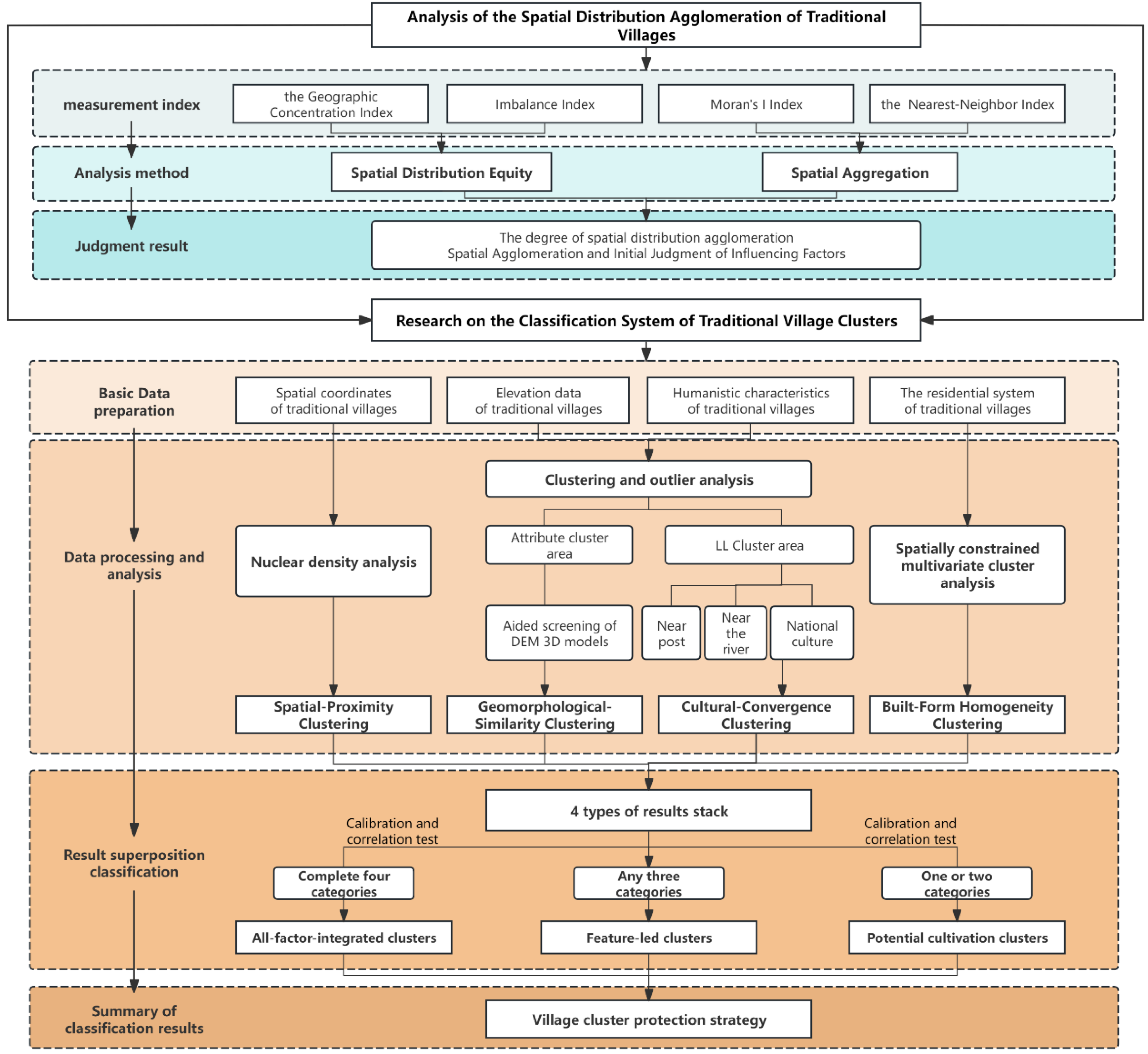
3.3.1. Research Framework
3.3.2. Spatial Distribution of Traditional Villages in Central Yunnan
3.3.3. Cluster Differentiation of Traditional Villages in the Dianchi Area
Selection of Cluster-Identification Elements and Indicators
- (1)
- Spatial Proximity: Geographic proximity underpins cluster formation. Zhang Mo et al. [38] report that similar villages are typically located within 10 km of one another, and Hong Tingting et al. [35] likewise employ a 10 km threshold. However, given Central Yunnan’s rugged terrain—where steep slopes and mountain barriers significantly impede direct connections—the threshold is extended to 15 km to more accurately capture functional spatial adjacency.
- (2)
- Geomorphological Similarity.: Local drainage basins and landforms exert a defining influence on settlement patterns. Shared mountain ranges, river systems, and valley plains therefore serve as key drivers of village clustering. In mountainous terrain, villages separated by more than 15 km in straight-line distance may nonetheless be linked via river valleys or mountain passes; geomorphological analysis is thus essential for detecting such latent clusters.
- (3)
- Cultural Convergence: Culture embodies the core identity and intrinsic value of traditional villages. As a historic nexus of the “Southern Silk Road” and the “Tea-Horse Road”, Central Yunnan long facilitated intercultural exchange and trade, fostering both ancient-route and mercantile cultural traditions. Moreover, the region’s multi-ethnic mosaic [39]—home to Han, Yi, Bai, Hui, and other groups—has engendered rich minority cultural forms, while its interleaved mountain-valley landscape has given rise to distinctive agrarian practices. Accordingly, this study selects four representative cultural indicators—minority (ethnic) culture, ancient-route culture, agrarian culture, and trade culture—to capture cultural homogeneity.
- (4)
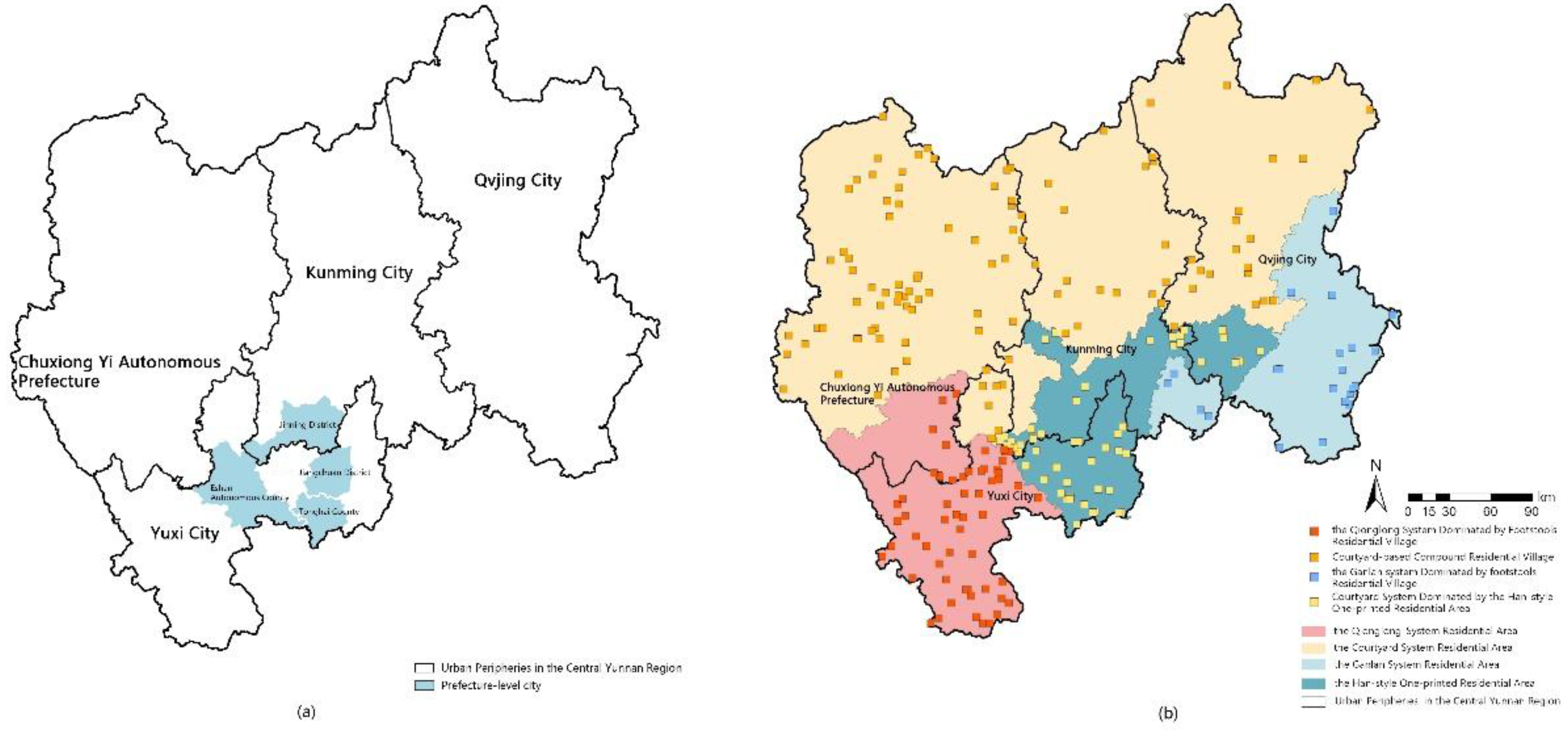
- Architectural Isomorphism: Village architecture constitutes the most direct material expression of village clustering, and its construction wisdom profoundly reflects the “mountain–water–field–forest–settlement” three-dimensional ecological adaptation mechanism, demonstrating a high degree of human–environment coordination [40]. In Central Yunnan, the complex topography, diverse climates, and a history of multi-ethnic settlement have given rise to vernacular building typologies that blend regional and ethnic characteristics—such as Yi-style dwellings and Han single-courtyard layouts—forms that not only satisfy subsistence and daily living needs but also embody cultural and esthetic traditions. Consequently, this study adopts four principal architectural indicators to identify clusters of similar dwellings: the Compound Courtyard System, the Qionglong System, the Stilt-House System, and the Han Single-Seal Courtyard [41].

| Cluster Identification Element | Indicator | Source |
|---|---|---|
| Spatial Proximity | Straight-line distance between villages within 15 km | [35,38] |
| Geomorphological Similarity | Shared mountain range, river system, or valley plain | |
| Cultural Convergence | Minority culture, ancient-route culture, agrarian culture, trade culture | [39] |
| Architectural Isomorphism | Compound Courtyard System, Qionglong System, Stilt-House System, Han Single-Seal Courtyard | [41] |
Single-Element Cluster Identification
- (1)
- Spatial Proximity Clustering
- (2)
- Geomorphological-Similarity Clustering
- (3)
- Cultural-Convergence Clustering
- (4)
- Built-Form Homogeneity Clustering
Multi-Element Cluster Identification
4. Results
4.1. Spatial Distribution Analysis of Traditional Villages in Central Yunnan
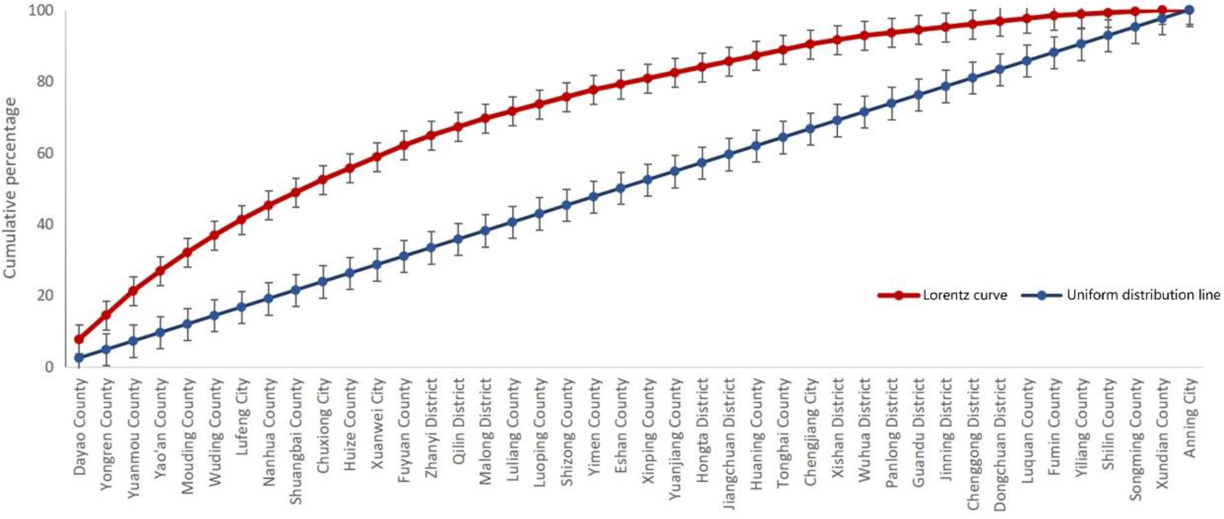
4.1.1. Analysis of Spatial Distribution Equity
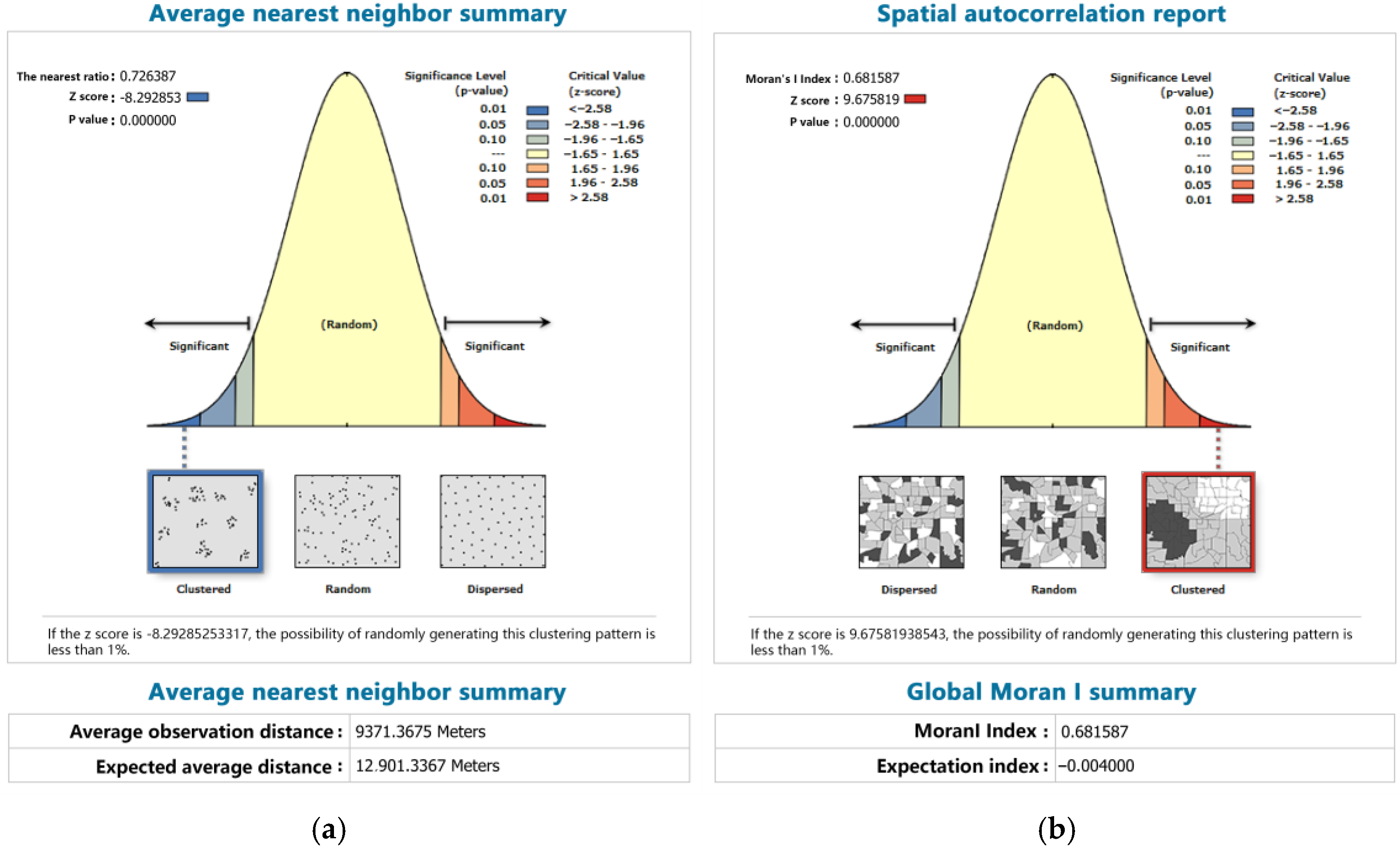
4.1.2. Analysis of Spatial Aggregation
4.1.3. Spatial Distribution of Traditional Villages and Their Influencing Factors
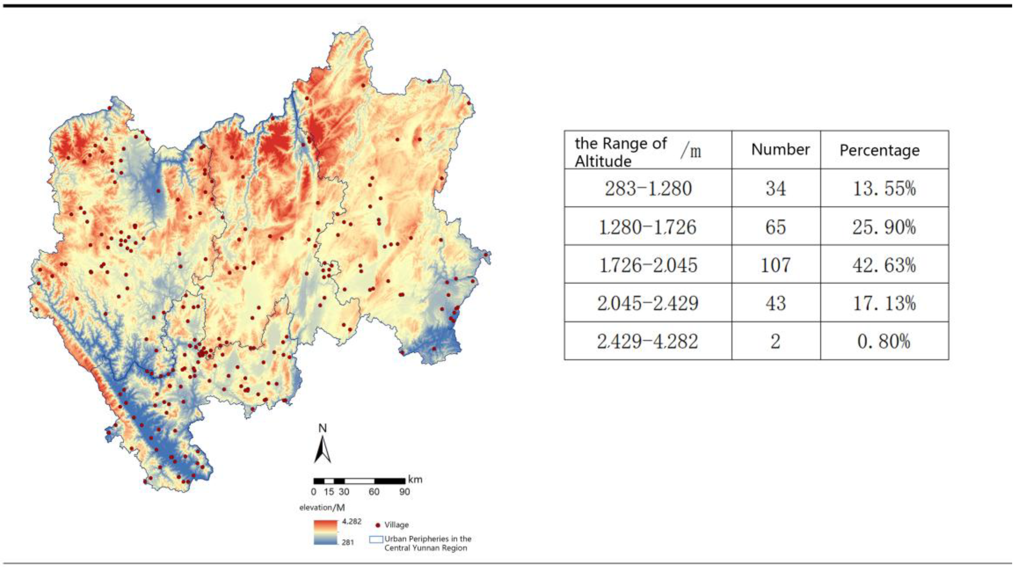
- (1)
- Relationship between Traditional Villages and Elevation
- (2)
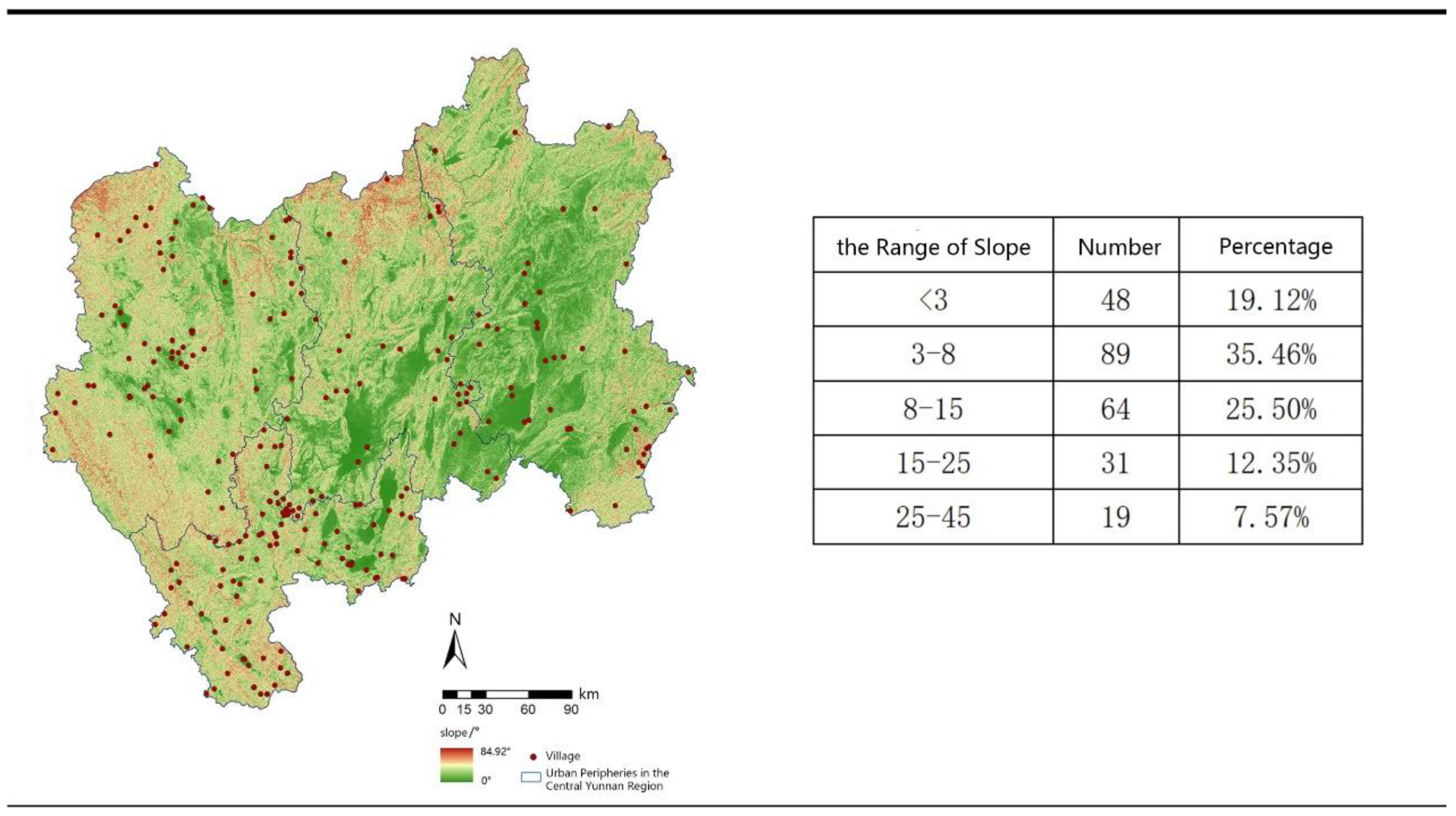
- Relationship between traditional villages and slopes
- (3)
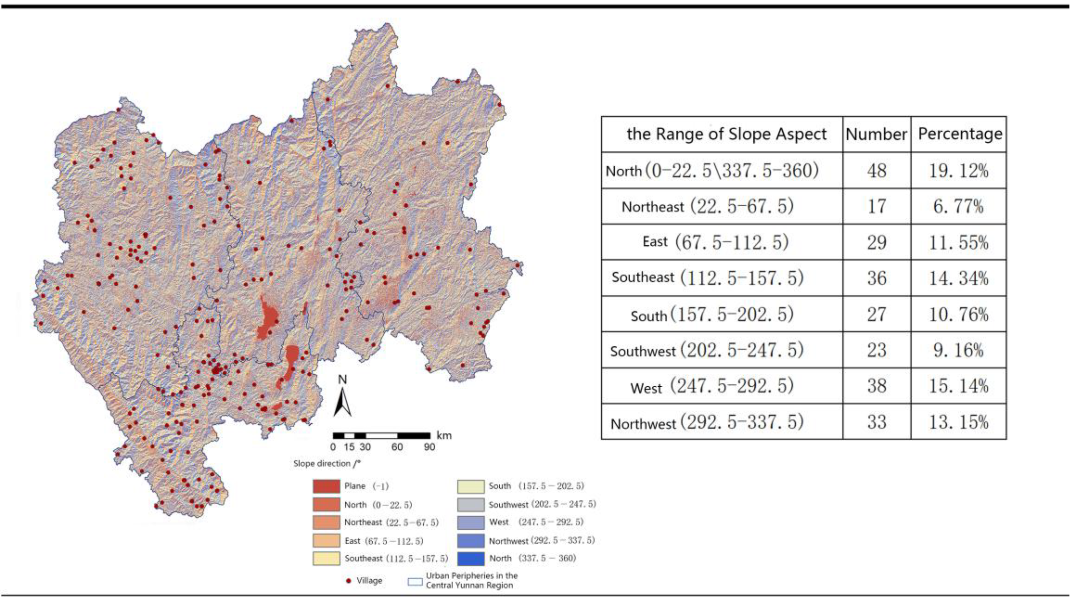
- The relationship between traditional villages and slope directions
- (4)
- Relationship between traditional villages and the distribution of major rivers
4.2. Results of the Identification of Traditional Villages in the Central Yunnan Region
4.2.1. Clustering Characteristics of Traditional Villages in the Central Yunnan Region Based on a Single Factor
Spatial Proximity Clustering Characteristics
Geomorphic Similarity Clustering Characteristics
Cultural Convergence Clustering Characteristics
Features of Building Isomorphism Clustering
4.2.2. Characteristics of Traditional Villages in the Central Yunnan Region
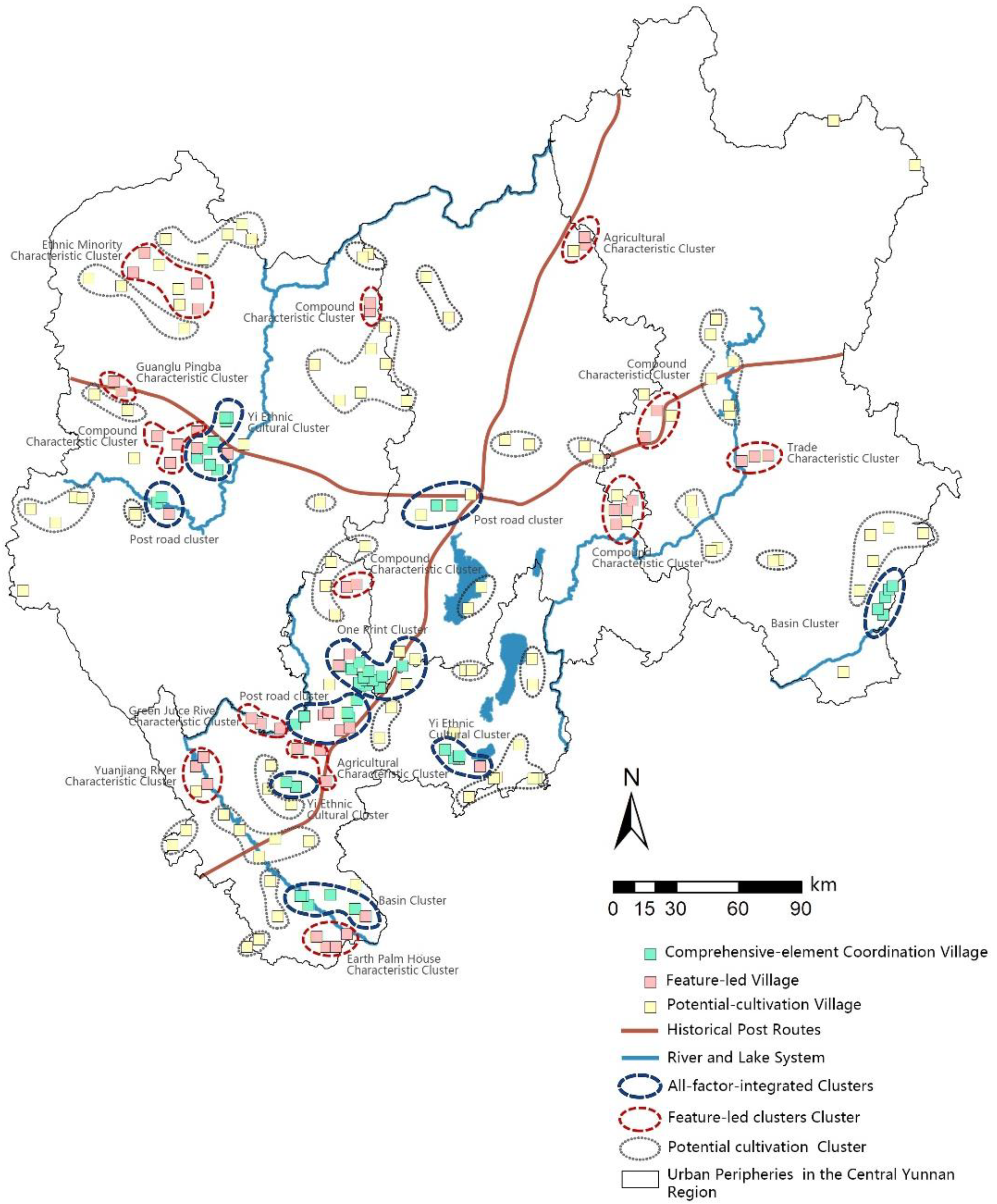
Characterization of All-Factor-Integrated Clusters
- (1)
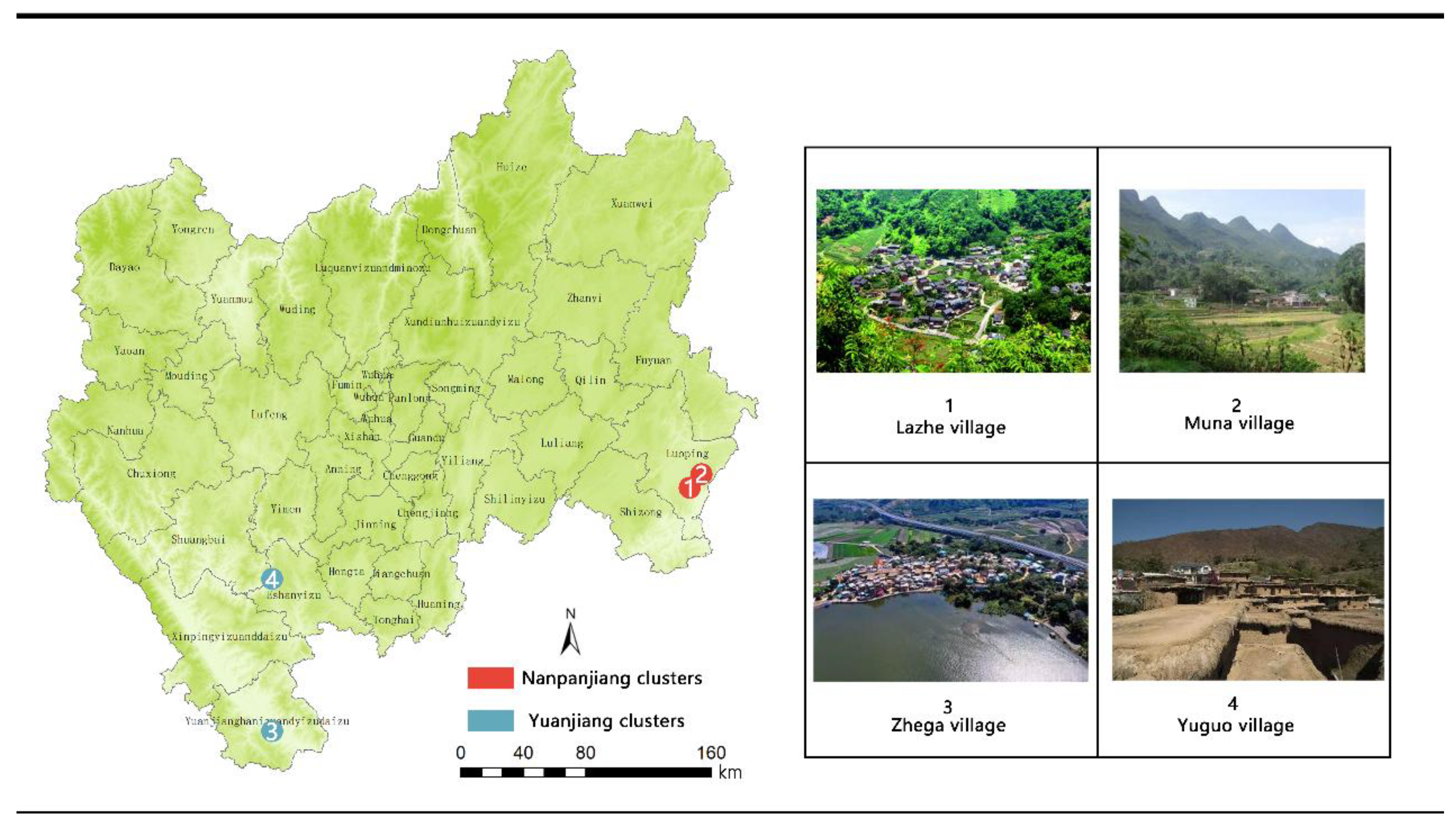
- The Nanpanjiang River, as the primary source of the Pearl River, historically served as a crucial waterway and cultural corridor linking Yunnan, Guizhou, and Guangxi. Its narrow valley features significant elevation differences between the river and flanking mountains. Villages predominantly occupy river terraces or basin areas, aligning with the watercourse. Development here reflects influences from shipping trade and multi-ethnic integration, blending commercial culture, Dai water culture, and Han agricultural traditions. The cluster primarily features stilt-house dwellings (Figure 15a) with elevated living quarters above flood-prone ground floors, facilitating moisture control and cargo handling.
- (2)
- The Yuanjiang Basin lies within Central Yunnan’s dry-hot valleys, characterized by alternating alluvial plains and mountainous gorges. Villages adopt spot-belt distributions along river terraces or piedmont highlands. Historically a nexus for ethnic migration and garrison settlements, it exhibits prominent multi-ethnic cohabitation and cultural inter-embedding. Vernacular architecture here is typified by Qionglong-style rammed earth flat-roof houses (Figure 15b), featuring compacted earth walls and soil-covered roofs for thermal regulation. Together, these clusters embody the developmental logic of “water-driven prosperity and ethnic integration”, demonstrating the fusion of spatial, geomorphic, cultural, and constructional dimensions under hydrological influences.
Characterization of Feature-Dominant Clusters
- (1)
- First, spatially dominated clusters include the Jiasa River Basin Cluster, Lüzhi River Basin Cluster, and Guanglu Town Basin Cluster. Traditional villages in these areas form compact belt-shaped or clustered distributions along water systems, exhibiting strong spatial connectivity and distinct geographic concentration. The Jiasa River Basin Cluster is located in Yuanjiang Hani, Yi, and Dai Autonomous County; the Lüzhi River Basin Cluster in Eshan Yi Autonomous County; and the Guanglu Town Basin Cluster in Yao’an County, Chuxiong Yi Autonomous Prefecture. Vernacular dwellings predominantly feature rammed earth flat-roof houses adapted to local topography and climate, reflecting significant environmental influences on architectural forms.
- (2)
- Second, vernacular dwelling-dominated clusters are subdivided into courtyard-style and rammed earth flat-roof house types. The former concentrates along Central Yunnan’s ancient post roads, characterized by Han-style “Yikeyin” configurations, where architectural ensembles and caravan posthouse remnants collectively form “trade-architecture” composite landscapes. The latter primarily occupies the western Yuanjiang Basin (southern Yuanjiang Hani, Yi, and Dai Autonomous County), representing a core distribution area of Qionglong-style rammed earth houses. Their thick-walled, flat-roof structures demonstrate regional adaptability to dry-hot valley climates.
- (3)
- Third, culturally dominated clusters comprise agricultural culture clusters, trade culture clusters, and ethnic minority clusters. Agricultural culture clusters distribute across western Eshan Yi Autonomous County and eastern Dongchuan District, Kunming, preserving traditional farming systems with village layouts closely aligned with agricultural patterns. Trade culture clusters focus in central Qilin District, Qujing, distinguished by ancient ceramic kiln culture. Historically formed through prosperous kiln trade, they exhibit settlement patterns interweaving workshops, marketplaces, and residences; compact courtyard layouts primarily feature enclosed quadrangle dwellings integrating habitation and artisanal production, fully reflecting trade activities’ profound impact on spatial morphology and social structure. Ethnic minority clusters locate at the border of Dayao and Yong’an counties, predominantly Yi traditional villages. Their dwellings incorporate vibrant ethnic motifs and patterns based on enclosed quadrangle frameworks, demonstrating distinctive cultural representation in architectural forms.
Characterization of Potential Cultivation-Type Clusters
5. Discussion
- (1)
- In terms of spatial and geomorphological features, the villages in central Yunnan exhibit a composite feature of ‘belt + cluster’, which differs from the ‘one-center-multiple-point’ result of analyses by Hong Tingting and other researchers [35]. This difference stems from the ‘valley effect’ in the distribution of villages in the mountainous highland environment: villages form linear agglomerations along the deep valleys of the Jinsha and Yuanjiang rivers, whereas the Zhangzhou Coastal Plain exhibits a faceted expansion pattern. The study confirms that the geographic environment significantly influences the selection of traditional methods for identifying village clusters.
- (2)
- In terms of cultural mechanisms, the two dominant modes of ‘ancient road dependence’ and ‘ethnic symbiosis’ in central Yunnan reflect a unique cultural and economic driving force. Their spatial distribution is closely related to the history of the intermingling of Han and Yi cultures, and to the salt and tea trade. This is a phenomenon that is rarely seen in studies of traditional villages in East Asia. This feature is uncommon in studies of traditional East Asian villages. As a hub of the Southern Silk Road, the linear cultural corridors formed by the horse-gang trade in Central Yunnan demonstrate significant spatial continuity. In contrast, the coastal villages of Zhangzhou formed discrete cultural clusters through harbor trade. This corroborates the idea that inland mountain culture transmission relies on linear corridors, whereas coastal areas are more likely to form networked cultural associations [44]. This finding echoes Hong Tingting et al.’s findings in the Fujian Tulou cluster but adds a new dimension to the interpretation of cluster formation through inter-ethnic trade networks [35]. However, the anomalous cultural homogeneity rate of 61.8% exposes the crisis of cultural fragmentation in marginalized urbanized areas, revealing the current situation of villages being abandoned and highlighting the urgent need for precise intervention.
- (3)
- In terms of building characteristics, the unique vertical adaptation system of the ‘Qionglong–Ganlan system’ in central Yunnan has been identified. Its three-dimensional spatial organization contrasts with the horizontal expansion pattern of the ‘Huilou–Paihu system’ in Zhangzhou, showcasing the contrasting wisdom of eastern and western architecture. Notably, the Han-style ‘one seal’ dwellings formed distinct clusters in Kunming City, confirming the influence of the Ming dynasty’s military system on central Yunnan’s architectural culture. This provides a new empirical basis for the ‘cultural superposition’ theory in historical geography.
6. Conclusions
- (1)
- Geographically constrained research scope;
- (2)
- Insufficient consideration of socio-economic variables in clustering;
- (3)
- Cultural analysis reliance on historical documents with inadequate quantification of implicit cultural genes;
- (4)
- Partial capture of villages’ temporal dynamics.
Author Contributions
Funding
Data Availability Statement
Acknowledgments
Conflicts of Interest
References
- Li, X.; Li, Z. Delineation of traditional village boundaries: The case of Haishangqiao village in the Yiluo River Basin, China. PLoS ONE 2022, 17, e0279042. [Google Scholar] [CrossRef]
- Hu, Z.; Liu, P.L.; Tan, M. Cultural landscape genome maps: A scientific language perspective of traditional settlements. Sci. Geogr. Sin. 2024, 44, 1309–1321. [Google Scholar]
- Xue, F.; Lin, W.; Jia, Q. Exploring the reasons for the spatial mismatch between coastal intangible cultural heritage and traditional villages: Integrating intangible cultural heritage to heal mental health strategies and regain cultural identity. Medicine 2025, 104, 25–26. [Google Scholar]
- Zhao, X.; Xue, P.; Wang, F.; Qin, Y.; Duan, X.; Yang, Z. How to become one? The modern bond of traditional villages in centralized contiguous protection and utilization areas in China. Habitat Int. 2024, 145, 103018. [Google Scholar] [CrossRef]
- Gao, J.; Wu, B. Revitalizing traditional villages through rural tourism: A case study of Yuanjia Village, Shaanxi Province, China. Tour. Manag. 2017, 63, 223–233. [Google Scholar] [CrossRef]
- Liu, S.; Ge, J.; Bai, M.; Yao, M.; He, L.; Chen, M. Toward classification-based sustainable revitalization: Assessing the vitality of traditional villages. Land Use Policy 2022, 116, 106060. [Google Scholar] [CrossRef]
- Mu, Q.; Aimar, F. How are historical villages changed? A systematic literature review on European and Chinese cultural heritage preservation practices in rural areas. Land 2022, 11, 982. [Google Scholar] [CrossRef]
- Hu, L.; Dong, S.B. Characteristics of the main-body practice in rural revitalization in Japan: A case study of the flexible use of cultural heritage. Res. Agric. Mod. 2022, 43, 390–397. [Google Scholar]
- Park, Y.-N.; Lee, C.-K.; Mjelde, W.J.; Kwon, Y.-J. Policy implications of willingness to pay for sustainable development of a world agricultural heritage site: The role of stakeholders’ sustainable intelligence, support, and behavioral intention. Sustain. Dev. 2021, 30, 636–646. [Google Scholar] [CrossRef]
- Xiao, W.; Huang, E.; Li, C.; Zhang, Y.; Wang, L. Investigating the spatial distribution and influencing factors of traditional villages in Qiandongnan based on ArcGIS and geodetector. Sci. Rep. 2025, 15, 5786. [Google Scholar] [CrossRef]
- Chunla, L.; Mei, X. Characteristics and influencing factors on the hollowing of traditional villages—Taking 2,645 villages from the Chinese traditional village catalogue (Batch 5) as an example. Int. J. Environ. Res. Public Health 2021, 18, 12759. [Google Scholar] [CrossRef]
- Zhang, H.; Chen, J.; Zhou, C. Research review and prospects of traditional villages in China. City Plan. Rev. 2017, 41, 74–80. [Google Scholar]
- Pendlebury, J. The conservation of historic areas in the UK: A case study of “Grainger Town”, Newcastle upon Tyne. Cities 1999, 16, 423–433. [Google Scholar] [CrossRef]
- Lindberg, A. Residents’ attitudes towards tourism in Bigodi village, Uganda. Tour. Manag. 2006, 28, 876–885. [Google Scholar] [CrossRef]
- Dewi, L.K.Y. Modeling the relationships between tourism sustainable factor in the traditional village of Pancasari. Procedia Soc. Behav. Sci. 2014, 135, 57–63. [Google Scholar] [CrossRef]
- Bhadauria, T.; Kumar, P.; Kumar, R.; Maikhuri, R.K.; Rao, K.S.; Saxena, K.G. Earthworm populations in a traditional village landscape in Central Himalaya, India. Appl. Soil Ecol. 2012, 53, 83–93. [Google Scholar] [CrossRef]
- Palang, H.; Helmfrid, S.; Antrop, M.; Alumäe, H. Rural landscapes: Past processes and future strategies. Landsc. Urban Plan. 2003, 70, 3–8. [Google Scholar] [CrossRef]
- Stirn, M. Modeling site location patterns amongst late-prehistoric villages in the Wind River Range, Wyoming. J. Archaeol. Sci. 2014, 41, 523–532. [Google Scholar] [CrossRef]
- Kılıç, D.; Yagci, C.; Iscan, F. A GIS-based multi-criteria decision analysis approach using AHP for rural settlement site selection and eco-village design in Erzincan, Turkey. Socio-Econ. Plan. Sci. 2023, 86, 101478. [Google Scholar] [CrossRef]
- Hu, Z. Retrospects and outlooks on the research of cultural landscape gene of traditional settlements. Geogr. Geo-Inf. Sci. 2024, 40, 80–87. [Google Scholar]
- Wang, Y.; Cao, K.; Zheng, D. Study on the pattern and path of integrated protection and development of traditional villages in county areas: A case study based on Guangshan County. South Archit. 2025, 03, 62–73. [Google Scholar]
- Zhao, Q.; Ren, Y.Y. Pattern matching system of traditional village pattern ecological protection based on cluster analysis. Fresenius Environ. Bull. 2021, 30, 6509–6515. [Google Scholar]
- Xue, Q.; Huang, Y. Construction method of the concentrated contiguous protection and utilization pattern for traditional villages: An empirical study of Liangdang County, Gansu Province. Planners 2024, 40, 66–74. [Google Scholar]
- Jing, F.; Zhang, J.; Du, Y. Heritage values of ancient vernacular residences in traditional villages in Western Hunan, China: Spatial patterns and influencing factors. Build. Environ. 2020, 173, 107473. [Google Scholar] [CrossRef]
- Yu, F.; Willey, W.J.J. The evolution of human population distance to water in the USA from 1790 to 2010. Nat. Commun. 2019, 10, 430. [Google Scholar]
- Ghaderi, Z.; Henderson, C.J. Sustainable rural tourism in Iran: A perspective from Hawraman Village. Tour. Manag. Perspect. 2012, 2, 347–354. [Google Scholar] [CrossRef]
- Geertz, C. Form and variation in Balinese village structure. Am. Anthropol. 1959, 61, 991–1012. [Google Scholar] [CrossRef]
- Xiao, X.; Tang, C.; Liang, W. Spatial distribution and cultural features of traditional villages in Beijing and influencing factors. J. Resour. Ecol. 2022, 13, 1074–1086. [Google Scholar] [CrossRef]
- Shen, H.; Aziz, F.N.; Lv, X. Using 360-degree panoramic technology to explore the mechanisms underlying the influence of landscape features on visual landscape quality in traditional villages. Ecol. Inform. 2025, 86, 103036. [Google Scholar] [CrossRef]
- Sprague, D.S. Land-use configuration under traditional agriculture in the Kanto Plain, Japan: A historical GIS analysis. Int. J. Geogr. Inf. Sci. 2013, 27, 68–91. [Google Scholar] [CrossRef]
- Xu, J.; Meng, W.; Yang, W.; Lu, Z.; Xie, G.; Wang, X. Impact of transition spaces on the indoor thermal environment: A case study of traditional dwellings in Southern Shaanxi, China. J. Build. Eng. 2024, 95, 110283. [Google Scholar] [CrossRef]
- Starková, L. A Post-Anfal Village in Iraqi Kurdistan: The Remote Sensing Retrogressive analysis. Appl. Sci. 2021, 11, 4208. [Google Scholar] [CrossRef]
- Karagianni, I. Heritage policy meets community praxis: Widening conservation approaches in the traditional villages of central Greece. J. Rural Stud. 2021, 81, 47–58. [Google Scholar] [CrossRef]
- Zhang, M.; Shen, C.; Gu, W.; Ge, J.; Wang, Y.; Liu, S. Identification of traditional village aggregation areas from the perspective of historic layering: Evidence from hilly regions in Zhejiang Province, China. Land 2023, 12, 2088. [Google Scholar] [CrossRef]
- Hong, T.T.; Lai, Z.P.; Huang, X.H.; Zheng, Y. Identification and protection of traditional village clusters based on clustering analysis: A case study of Zhangzhou City. Landsc. Archit. 2023, 30, 121–129. [Google Scholar] [CrossRef]
- Renping, W.; Zhenyu, C. An ecological assessment of vernacular architecture and its embodied energy in Yunnan, China. Build. Environ. 2005, 41, 687–697. [Google Scholar] [CrossRef]
- Gao, W.; Zhuo, X.; Xiao, D. Spatial patterns, factors, and ethnic differences: A study on ethnic minority villages in Yunnan, China. Heliyon 2024, 10, e27677. [Google Scholar] [CrossRef]
- Zhang, M.; Zhu, Y.R.; Yu, T. Spatial distribution of traditional villages and the influencing factors in Qingdao. Mod. Urban Res. 2020, 12, 18–28. [Google Scholar]
- Gao, W.; Xiao, D.; Zhao, Y.; Tao, J.; Zhuo, X. Study on the cultural landscape characteristics and influencing factors of traditional villages and dwellings in Central Yunnan Region. Archit. J. 2023, S1, 194–200. [Google Scholar]
- Gao, N.; Wu, C.; Bai, K.; Ma, Y. Spatial differentiation and influencing factors of Chinese traditional villages. J. Shaanxi Norm. Univ. Nat. Sci. Ed. 2020, 48, 97–107. [Google Scholar]
- Zheng, S.; Wei, L.; Yu, H.; Kou, W. UAV imagery-based classification model for atypical traditional village landscapes and their spatial distribution pattern. Drones 2024, 8, 297. [Google Scholar] [CrossRef]
- Shao, D.; Zoh, K. Analysis of spatial distribution characteristics and driving factors of ethnic-minority villages in China using geospatial technology and statistical models. J. Mount. Sci. 2024, 21, 2770–2789. [Google Scholar] [CrossRef]
- Zhang, Y.; Han, N.; Zhang, B.; Lu, C.; Yang, M.; Zhai, F.; Li, H. Spatial and temporal distribution characteristics and evolution of traditional villages in the Qihe River Basin of China. Sci. Rep. 2025, 15, 94872. [Google Scholar] [CrossRef] [PubMed]
- Hedan, M.; Tian, Y. Spatial differentiation of traditional villages using ArcGIS and GeoDa: A case study of Southwest China. Ecol. Inform. 2021, 66, 101416. [Google Scholar]
- Lu, X.; Peng, Z.; Zhou, Y.; Xie, Y.; Chen, Z. A study on the spatial distribution characteristics and driving factors of traditional villages in the southeast coast of China: A case study of Puxian, Fujian. PLoS ONE 2024, 19, e0303746. [Google Scholar] [CrossRef] [PubMed]
- Cui, H.; Chen, X.; Chen, C.; Wang, T.; Wang, J.; Shi, D. Spatial heterogeneity and formation mechanism of ethnic groups’ villages in the Yangtze River Basin. Econ. Geogr. 2023, 43, 160–171. [Google Scholar]
- Chen, T.; Zhang, Y.; Wang, J.; Wu, B.; Yang, Y. How Does Urban Compactness Affect Green Total Factor Productivity? An Empirical Study of Urban Agglomerations in Southwest China. Sustainability 2025, 17, 6612. [Google Scholar] [CrossRef]


| Original Dataset | Source | Data Type | |
|---|---|---|---|
| Traditional Village List | China Traditional Villages | Ministry of Housing and Urban-Rural Development of the People’s Republic of China (https://www.mohurd.gov.cn/?c=0; accessed on 10 February 2025) | Point |
| China Historical and Cultural Towns and Villages | |||
| China Ethnic Minority Characteristic Villages | National Ethnic Affairs Commission of the People’s Republic of China (https://www.neac.gov.cn/seac/index.shtml; accessed on 10 February 2025) | ||
| Historical and Cultural Towns (Villages and Streets) of Yunnan Province | Yunnan Provincial Department of Housing and Urban-Rural Development (https://zfcxjst.yn.gov.cn/; accessed on 10 February 2025) | ||
| Ethnic Minority Characteristic Villages of Yunnan Province | Yunnan Provincial Ethnic and Religious Affairs Commission (https://mzzj.yn.gov.cn/; accessed on 10 February 2025) | ||
| China and Central Yunnan Administrative Boundaries | National Geographic Information Resources Catalog Service System (https://www.webmap.cn/main.do?method=index; accessed on 10 February 2025) | Polygon | |
| Hydrographic Network | OpenStreetMap https://openstreetmap.maps.arcgis.com/home/index.html (accessed on 15 February 2025) | Line | |
| Historical Courier Routes | China Historical Atlas; Yunnan Provincial Gazetteer (book sources) | Line | |
| Digital Elevation Model (12.5 m) | ALOS PALSAR Project (https://www.earthdata.nasa.gov/data/projects/alos-palsar-rtc-project; accessed on 10 February 2025) | Vector | |
| Method | Formula | Parameter | Source |
|---|---|---|---|
| (1) Geographic Concentration Index | G: Geographic concentration index; Xi: the number of traditional villages in the i-th city in the Lingnan Region; T: the number of total study areas; n: Number of study areas | [31] | |
| (2) Imbalance Index | S: Imbalance index; Yi: Cumulative percentage of subjects sorted from largest to smallest within the total study area; n: Number of study areas | [10] | |
| (3) Nearest Neighbor Index | r1: Average distance between neighboring points; rE: theoretical nearest neighbor distance; D: heritage point density | ||
| (4) global Moran index | n: Number of study areas; Xi and Xj: Study the number of units i and j; : Average number of subjects; Wij: spatial weights matrix | [37] |
| Method | Formula | Parameter | Source | |
|---|---|---|---|---|
| (5) Kernel density estimation method | x: Coordinates of the position to be estimated; xi: Coordinates of the i-th observation point; h: Bandwidth; K(⋅): Kernel function | [37] | ||
| (6) Cluster and outlier analysis | Ii: Spatial autocorrelation index; Zi: Normalized value of i unit observation; Zj: Normalized value of j unit observation; Wij: Spatial weight between features i, j | [40] | ||
| (7) Fractional analysis | Attribute similarity calculation | Dij: Similarity distance between features i and j; Wk: Weight of k-th analysis field; xik: Normalized value of feature i in k-th analysis field | [35] | |
| Spatial constraint integration | dij: Feature spacing; dmax: maximum neighborhood distance | |||
| Optimization objective function | Minimize | C: Default number of groups; α: Attribute similarity weight; β: Spatial constraint weight; Sic: Spatial constraint penalty terms for feature i and cluster center c | ||
| Group quality assessment | T: Sum of squares of total deviations; PG: Sum of squares of within-group deviations G: Actual number of groups N: Total number of elements | |||
| Cluster Category | Score | Traditional Village Clusters | Traditional Villages Sub-Cluster | Number of Villages |
|---|---|---|---|---|
| All-factor-integrated clusters | 4 | Watershed clusters | Nanpanjiang cluster | 5 |
| Yuanjiang cluster | 7 | |||
| Stagecoach clusters | the South Yunnan Guanma Ancient Road cluster | 6 | ||
| the Yunnan-Tibet Tea and Horse Ancient Road clusters | 4 | |||
| One-seal clusters | Xiyang countryside clusters | 10 | ||
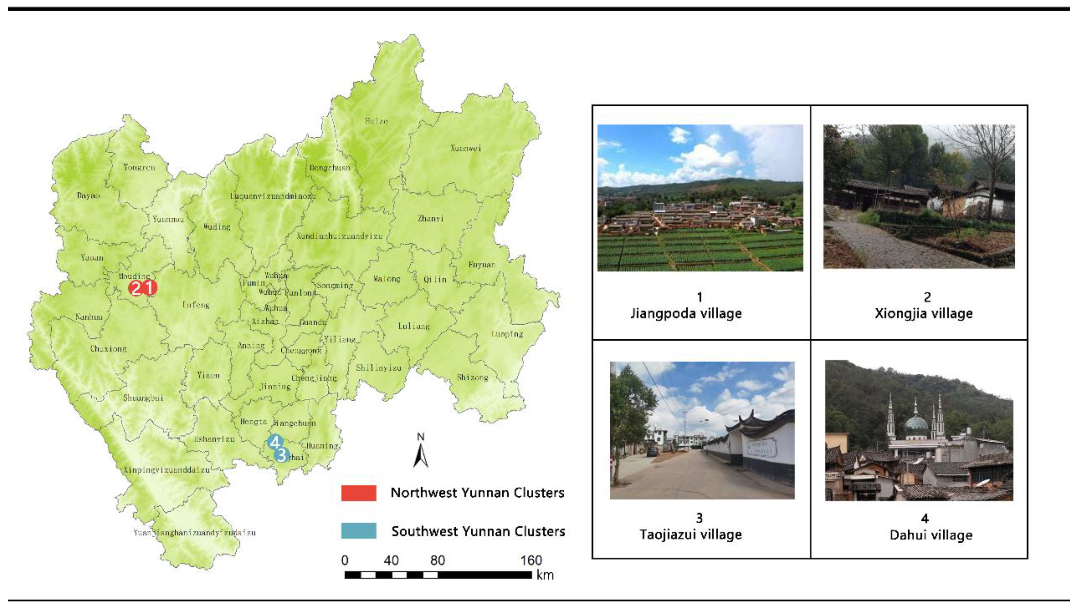
| Yi culture clusters | Northwest Yunnan clusters | 8 | ||
| Southwest Yunnan clusters | 7 | |||
| Feature-led clusters | 3 | The spatially dominant clusters | Jashan River Basin Clusters | 3 |
| the Green Ju River Basin Clusters | 3 | |||
| The Pingba district clusters in guanglu township | 2 | |||
| Dwelling-led settlement clusters | The walled courtyards specialty dominant clusters | 19 | ||
| The earth palm houses Specialty Dominant Clusters | 7 | |||
| The culture-led clusters | The farming culture clusters | 5 | ||
| The trade culture dominant clusters | 3 | |||
| The ethnic minority dominant clusters | 9 | |||
| Potential cultivation clusters | 1~2 | — | — | 102 |
| Non-clustered traditional villages | 0 | — | — | 51 |
Disclaimer/Publisher’s Note: The statements, opinions and data contained in all publications are solely those of the individual author(s) and contributor(s) and not of MDPI and/or the editor(s). MDPI and/or the editor(s) disclaim responsibility for any injury to people or property resulting from any ideas, methods, instructions or products referred to in the content. |
© 2025 by the authors. Licensee MDPI, Basel, Switzerland. This article is an open access article distributed under the terms and conditions of the Creative Commons Attribution (CC BY) license (https://creativecommons.org/licenses/by/4.0/).
Share and Cite
Chen, T.; Zhang, S.; Chen, J.; Duan, J.; Zhang, Y.; Yang, Y. Spatial Distribution Characteristics and Cluster Differentiation of Traditional Villages in the Central Yunnan Region. Land 2025, 14, 1565. https://doi.org/10.3390/land14081565
Chen T, Zhang S, Chen J, Duan J, Zhang Y, Yang Y. Spatial Distribution Characteristics and Cluster Differentiation of Traditional Villages in the Central Yunnan Region. Land. 2025; 14(8):1565. https://doi.org/10.3390/land14081565
Chicago/Turabian StyleChen, Tao, Sisi Zhang, Juan Chen, Jiajing Duan, Yike Zhang, and Yaoning Yang. 2025. "Spatial Distribution Characteristics and Cluster Differentiation of Traditional Villages in the Central Yunnan Region" Land 14, no. 8: 1565. https://doi.org/10.3390/land14081565
APA StyleChen, T., Zhang, S., Chen, J., Duan, J., Zhang, Y., & Yang, Y. (2025). Spatial Distribution Characteristics and Cluster Differentiation of Traditional Villages in the Central Yunnan Region. Land, 14(8), 1565. https://doi.org/10.3390/land14081565