Abstract
As an integral component of humanity’s cultural heritage, traditional villages universally confront challenges such as population loss and cultural discontinuity amid rapid urbanization. Cluster-based protection models have increasingly become the international consensus for addressing the survival crisis of such settlements. This study selects the Central Yunnan region of Southwest China—characterized by its complex geography and multi-ethnic habitation—as the research area. Employing ArcGIS spatial analysis techniques alongside clustering algorithms, we examine the spatial distribution characteristics and clustering patterns of 251 traditional villages within this region. The findings are as follows. In terms of spatial distribution, traditional villages in Central Yunnan are unevenly dispersed, predominantly aggregating on mid-elevation gentle slopes; their locations are chiefly influenced by rivers and historical courier routes, albeit with only indirect dependence on waterways. Regarding single-cluster attributes, the spatial and geomorphological features exhibit a composite “band-and-group” pattern shaped by river valleys; culturally, two dominant modes emerge—“ancient-route-dependent” and “ethnic-symbiosis”—reflecting an economy-driven cultural mechanism alongside latent marginalization risks. Concerning construction characteristics, the “Qionglong-Ganlan” and Han-style “One-seal” residential features stand out, illustrating both adaptation to mountainous environments and the cumulative effects of historical culture. Based on these insights, we propose a three-tiered clustering classification framework—“comprehensive-element coordination”, “feature-led”, and “potential-cultivation”—to inform the development of contiguous and typological protection strategies for traditional villages in highland, multi-ethnic regions.
1. Introduction
Traditional villages, as significant cultural representations of human settlement forms, are widely embedded within the spatial frameworks of various civilizational evolutions and constitute core components of cultural landscapes [1]. Although different countries employ diverse terms—such as “traditional village”, “historic settlement”, “ancient village”, or “vernacular village”—this category of cultural heritage universally embodies profound historical sedimentation, distinctive regional cultural characteristics, and complex human–environment relationships [2]. UNESCO’s inclusion of cultural landscapes in the World Heritage List, emphasizing their living preservation, holistic protection, and sustainable development, marks an international consensus on the systematic recognition of the cultural value of traditional settlements: they are not only repositories for tangible cultural heritage but also active venues for the vivification of intangible cultural assets [3]. Therefore, protecting traditional villages is of paramount importance for maintaining cultural diversity and promoting their sustainable development.
Conventional conservation approaches focus on individual villages, emphasizing physical restoration and static preservation of built fabric [4]. Although point-based protection can slow the decay of heritage assets, with accelerating urbanization and modernization, this singular conservation paradigm has led traditional villages to face marginalization, population decline, ruptures in cultural transmission, and fragmented management [5]. In this context, cluster-based conservation has gradually emerged as the international consensus [6]. By identifying the cultural, ecological, and historical commonalities and differences among villages, cluster-based protection facilitates cross-settlement resource allocation and coordinated governance, offering a transformative path to address the survival crisis of heritage in a globalizing world.
Differences in geographic location, cultural background, ecological environment, and other factors have given rise to diverse approaches to cluster-based conservation worldwide. How to develop location-specific, adaptive protection strategies has therefore become an urgent question in the field of village preservation. Since the mid-20th century, developed countries have been at the forefront of exploring cluster-based conservation: France’s “Les Plus Beaux Villages de France” certification system [7], Japan’s “One Village, One Product” movement [8], and South Korea’s agricultural cultural heritage protection framework [9], all exemplify a shared consensus on reinforcing village preservation through cultural activation, functional regeneration, and ecological integration. By contrast, in developing countries, conservation practices for traditional villages generally did not commence until the late 20th century, and scholarly research has lagged accordingly. Among these, China—being the world’s largest developing country—although a late entrant to systematic conservation efforts, has already yielded a number of practical models that can inform global initiatives for cluster-based protection of traditional villages.
In 2003, China’s Ministry of Housing and Urban–Rural Development together with the State Administration of Cultural Heritage launched the selection of “Historic and Culturally Significant Towns and Villages.” Early conservation efforts predominantly focused on the restoration of individual buildings, paying insufficient attention to the cultural interconnections and spatial coordination among settlements. In 2012, the Ministry of Housing and Urban–Rural Development, the Ministry of Culture, and other departments jointly initiated a systematic nationwide identification of traditional villages, marking a new phase in China’s cultural heritage protection—shifting from the preservation of standalone structures to the holistic safeguarding of entire settlements. In 2020, the Ministry of Finance and the Ministry of Housing and Urban–Rural Development collaboratively organized the program for contiguous-area protection and utilization of traditional villages, aimed at strengthening their endogenous vitality and promoting sustainable development.
At present, China’s registers of protected traditional villages include the “List of Chinese Traditional Villages”, the “Catalogue of Chinese Historic and Culturally Significant Towns and Villages”, and the “List of Characteristic Ethnic Minority Villages in China.” Provincial and municipal authorities have also carried out their own levels of identification. As of October 2023, a total of 8155 villages have been inscribed on the national register of traditional villages; each registered village possesses unique folk customs and agricultural heritage. Although the establishment of this register system has achieved a quantitative breakthrough in the protection of China’s traditional villages, the current contiguous-area protection plans still face two major challenges: (1) cluster delineation is administratively driven and relies heavily on empirical judgment, lacking a quantitative assessment of cultural–geographical linkages; and (2) the formulation of protection objectives along a single dimension struggles to accommodate the heterogeneous needs of villages within a cluster, resulting in conflicts between conservation effectiveness and development aspirations.
In this context, the present study applies spatial analysis and clustering methods to identify the spatial aggregation characteristics and cluster patterns of traditional villages within the study area, with the aim of providing a theoretical foundation and optimization guidelines for strategies of contiguous-area and typological conservation of traditional villages, as well as contributing a Chinese perspective to the international theoretical framework of cluster-based protection of traditional settlements.
2. Literature Review
2.1. Traditional Villages and Their Cluster Research
Traditional villages have increasingly attracted academic attention, exhibiting characteristics of multi-scale and interdisciplinary study. In terms of research scale, the macro-level focuses on the distribution patterns of traditional villages at the national or interprovincial scale [10,11]; the meso-level concentrates on specific regional units—such as river basins, cultural corridors, or municipal jurisdictions—to analyze the features of traditional villages therein [12]; and the micro-level is devoted to case studies of individual villages. From the perspective of research topics, scholarship has primarily addressed heritage preservation mechanisms [13], tourism [14,15], cultural landscapes [16,17], and village-site selection models [18,19], among others. These studies provide essential support for a deeper understanding of the spatial formation processes of villages and their roles as carriers of culture.
The paradigm of traditional village conservation has evolved from protecting individual settlements to advocating cluster-based preservation. Early research mostly examined the material spatial characteristics or cultural “genes” of single villages [20], but with accelerated urbanization and the growing complexity of heritage protection, scholars have recognized that point-based conservation is inadequate for addressing issues such as dispersed resources and cultural discontinuity [5]. The emergence of the cluster-based conservation concept signifies a shift from “point restoration” toward “networked collaboration”, emphasizing the construction of village communities through spatial linkages, shared cultural traits, and complementary resources [21].
Against this backdrop, the classification of villages has become a foundational step for implementing cluster-based conservation, offering scientific support for delineating contiguous protection zones and devising differentiated conservation strategies. Current clustering research focuses on three levels: at the macro level, administrative divisions are used to examine interregional differences among villages to inform national-level classification policies; at the meso level, prefectural units assess and grade villages based on indicators such as vitality and the density of cultural resources to support localized differentiated management [6]; and at the micro level, the spatial morphology of specific traditional villages is analyzed to propose context-appropriate conservation and utilization strategies [22].
2.2. Spatial Distribution of Traditional Villages and Its Influencing Factors
Traditional villages are the product of long-term interactions between natural geographic conditions and human-social factors, and research on their spatial distribution has evolved from unidimensional analyses to more systemic investigations. A broad body of scholarship indicates that natural geographic elements and socio-economic variables constitute the primary determinants of where traditional villages are located.
Natural geographic conditions provide the fundamental basis for village formation. Xue Qianming et al. observe that contrasts among plains, mountains, and valleys directly shape patterns of human settlement and modes of livelihood [23]. Fu J. and colleagues demonstrate that climatic conditions exert a direct influence on the distribution of traditional villages, with markedly different settlement forms emerging under varying climate regimes [24]. Likewise, the availability of water resources is critical: driven by needs for household water, agricultural irrigation, and transport, communities have historically preferred to establish villages in proximity to rivers and streams [25].
Socio-economic dynamics further refine and differentiate village characteristics. Ghaderi identifies the intensity of economic activity as a key driver of village scale and spatial organization [26]. Geertz emphasizes that social structures—such as kinship groups, tribal affiliations, and religious institutions—also exert important effects on the spatial arrangement of settlements [27]. Moreover, other researchers argue that cultural practices related to ancient military defense, transportation corridors, and trade networks have left enduring imprints on the spatial patterning of traditional villages [28].
Collectively, these natural and socio-economic factors interact to produce the observed spatial configurations of traditional villages, underscoring the necessity of integrated, multivariate approaches in their study and conservation.
2.3. Applications of Spatial Analysis and Cluster Analysis
With the rapid advancement of computing technologies, digital tools such as Geographic Information Systems (GISs) have seen widespread application in spatial analysis [29]. For example, Sprague and colleagues employed multi-buffer analysis on historical maps to examine traditional villages in Japan, revealing their distinctive spatial structures [30]. Xu et al. applied methods including the nearest-neighbor index and kernel density estimation to disclose the distribution characteristics of 323 traditional villages in Shanxi Province, China [31]. Moreover, spatial analysis has evolved from static description to dynamic simulation: Iraqi scholars, using GIS-based overlay analysis of satellite imagery, systematically elucidated the evolutionary trajectories of rural settlements [32].
In terms of cluster analysis, researchers have predominantly constructed indicator systems to identify the characteristics of village clusters. Katapidi’s empirical study demonstrated the geographic agglomeration of Greek traditional settlements, uncovering structural differences in the spatial organization patterns across three core areas, including the Aegean Islands [33]. Zhang et al., employing a historically stratified approach, integrated natural, social, and cultural indicators to identify and classify 14 traditional-village clusters in the hilly regions of Zhejiang Province, thereby providing guidance for cluster-based conservation in that area [34]. Based on the geographic and cultural traits of Zhangzhou City, Hong Tingting et al. developed a quantitative cluster-recognition system encompassing four elements—spatial configuration, geomorphology, cultural attributes, and residential typology. Using an “elemental clustering overlay plus field verification” method, they conducted a comprehensive identification and analysis of traditional villages, and for the first time proposed three cluster types—“comprehensive-element”, “feature-led”, and “potential-cultivation”—along with corresponding conservation and development strategies. This work transcends the traditional paradigm of individual-village preservation, addresses gaps in regional coverage and depth of quantitative analysis, and offers both a technical pathway and theoretical reference for delineating contiguous protection zones for traditional villages in China [35].
2.4. Research on Villages in the Central Yunnan Region
Yunnan Province, located on China’s southwestern frontier, serves as a crucial gateway between China and Southeast and South Asia. The province’s topography is highly varied, with mountain ranges, plateaus, lakes, river valleys, and plains interwoven throughout. This ecological diversity has made Yunnan one of the world’s biodiversity hotspots. Over the course of its long historical evolution, numerous ethnic groups have converged and integrated across different geographic units, giving rise to a unique cultural–landscape mosaic. This distinctive combination of geography and culture has rendered Yunnan not only the region with the richest concentration of traditional villages in China but also one of the few globally where multiple ethnicities coexist in significant numbers. According to data released by China’s Ministry of Housing and Urban–Rural Development, Yunnan tops the national list in terms of the total number of officially recognized traditional villages, exhibiting pronounced historical continuity, cultural diversity, and ecological adaptability.
Despite the large number and variety of traditional villages in Yunnan, existing research has uneven geographic coverage. Most studies to date have focused on the overall distribution of traditional villages across the province, with particular emphasis on minority-concentrated areas such as western and southern Yunnan. By contrast, the Central Yunnan region has received relatively little scholarly attention. Historically positioned as the nexus between China’s interior and its frontier, the villages of Central Yunnan embody overlapping spatial characteristics of multiple ethnic groups, cultures, and functions. Especially within the distinctive context of the “ancient courier-route junction”, the spatial morphology of Central Yunnan villages is shaped not only by physical geography but also by the cultural dynamics of interethnic communication, exchange, and integration, resulting in unique patterns of spatial distribution and clustering.
Moreover, as the fastest-urbanizing region of Yunnan Province, Central Yunnan’s traditional villages face mounting pressures. Rapid urbanization has led to fragmentation of rural spatial forms and the gradual erosion of traditional village landscapes. Simultaneously, population mobility and cultural homogenization threaten to erode minority traditional knowledge, local memory, and cultural heritage. In this context, the protection and reappraisal of Central Yunnan’s traditional villages are not only vital to safeguarding regional cultural security but also hold significant theoretical and practical value for exploring cluster-based conservation pathways in highland, multiethnic areas.
3. Materials and Methods
3.1. Study Area
The Central Yunnan region is located in Southeast Asia, on China’s southwestern frontier, in the central part of Yunnan Province. It serves as the cultural, political, and economic center of the province, as well as China’s important gateway to South and Southeast Asia [36]. Geographically, it lies between 23°19′–27°03′ N latitude and 100°35′–104°32′ E longitude, encompassing the municipalities of Kunming and Yuxi, the Chuxiong Yi Autonomous Prefecture, and the city of Qujing (Figure 1). Covering an area of 94,558 km2—approximately 24 percent of the province’s total land area—the region had a permanent resident population of 17.245 million at the end of 2023, accounting for roughly 37 percent of Yunnan’s total population. Situated in the interior of the Yunnan-Guizhou Plateau, Central Yunnan exhibits the combined geomorphic features of highland mountains, faulted basins, and river valleys, and is characterized by a pronounced vertical climate gradient. Home to multiple ethnic groups, the region is also a focal zone for the interweaving of Han and minority cultures, featuring both spatial and cultural heterogeneity.
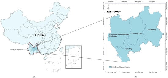
Figure 1.
Overview of the Central Yunnan Region: (a) location of the Central Yunnan region within Yunnan Province, China; (b) geographic setting and administrative boundaries of the Central Yunnan region (Maps drawn by the authors).
3.2. Data Sources and Preprocessing
Based on the registers of traditional villages, historic and culturally significant villages, and characteristic ethnic minority settlements published by China’s Ministry of Housing and Urban–Rural Development and the Yunnan Provincial Department of Housing and Urban–Rural Development, we collected the set of officially recognized traditional villages in the Central Yunnan region. To ensure the uniqueness of the research units, duplicate villages appearing across different registers were identified, cross-checked, and removed, yielding a consolidated baseline inventory of traditional villages in the Central Yunnan region.
As of March 2025, a total of 251 traditional villages had been validated in this area; these form the study sample for the present research.
Multi-level administrative boundary data for China and the Central Yunnan region were obtained from the National Geographic Information Resources Catalog Service System (https://www.webmap.cn/main.do?method=index; accessed 10 February 2025); a 12.5 m digital elevation model (DEM) was sourced from the ALOS PALSAR project (https://www.earthdata.nasa.gov/data/projects/alos-palsar-rtc-project; accessed 10 February 2025); and hydrographic data were derived from OpenStreetMap (https://openstreetmap.maps.arcgis.com/home/index.html; accessed 15 February 2025). Geographic coordinates for 251 villages were collected via Google Earth, and their elevation values were extracted by overlaying the DEM within ArcGIS. Historical courier routes in Central Yunnan were digitized and spatially processed in ArcGIS—drawing on sources such as the China Historical Atlas and the Yunnan Provincial Gazetteer—and subsequently rendered as linear vector data. These five datasets constitute the spatial vector data employed in this study.
Attributive data—including village names, administrative affiliations, and the year of official recognition—were compiled from the Yunnan Provincial Department of Housing and Urban-Rural Development, municipal and county government websites, and relevant policy documents. Additional attributes (historical evolution, ethnic composition, traditional architectural typologies, and cultural practices) were extracted from government gazettes, news reports, local gazetteers, and scholarly literature, then classified accordingly. All attribute information was organized in an Excel spreadsheet and linked to each village via a unique identifier and its coordinate data. Within the ArcGIS platform, these links enabled the assignment of comprehensive attribute fields to all 251 traditional villages.
Prior to analysis, every dataset underwent format standardization, coordinate projection correction, and topology validation to ensure spatial accuracy and consistency in ArcGIS. Detailed provenance and metadata for all sources are summarized in Table 1.

Table 1.
Data sources. Table was made by authors.
3.3. Methods
3.3.1. Research Framework
The methodological framework of this study is as follows: first, we assess the spatial distribution and clustering patterns of 251 traditional villages in the Central Yunnan region; next, we classify and integrate their attribute characteristics; and finally, we construct a classification system for village clusters (Figure 2).
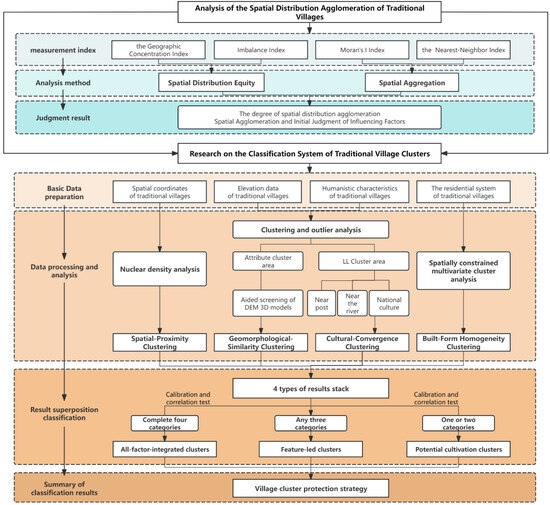
Figure 2.
Technology roadmap (Maps were drawn by authors).
Firstly, ArcGIS 10.7 was employed to analyze the spatial distribution characteristics of the 251 traditional villages in Central Yunnan, including assessments of distribution evenness and clustering; having elucidated these distribution patterns, the study then conducted a preliminary examination of the influence of natural geographic conditions on the traditional villages.
Secondly, based on the indicator system proposed by Hong Tingting et al. [35] and in light of Central Yunnan’s multi-ethnic settlement patterns and complex mountainous terrain, the original framework was locally adapted. Accordingly, this study establishes a four-dimensional element system—“spatial”, “geomorphological”, “cultural”, and “architectural”—and conducts an analysis of each individual dimension. Finally, a hierarchical overlay model is applied to couple these elements; villages are then categorized according to their various element combinations, resulting in a village classification system that reflects the distinctive characteristics of Central Yunnan (Figure 2).
3.3.2. Spatial Distribution of Traditional Villages in Central Yunnan
Multiple spatial analysis techniques were employed to investigate the spatial distribution characteristics of the 251 traditional villages in Central Yunnan (Table 2). First, the geographic concentration index and imbalance index were calculated to assess the overall evenness of village distribution, thereby revealing differences in resource allocation across administrative units. Second, the Average Nearest Neighbor index was used to classify the spatial pattern of village locations (random, dispersed, or clustered), with a Z-score test applied to evaluate statistical significance. Third, Global Moran’s I was computed to measure spatial autocorrelation and determine whether the village distribution exhibits significant spatial dependence. Finally, ArcGIS was utilized to analyze the relationships between village locations and environmental factors—elevation, aspect, slope, and proximity to rivers. The combined application of these methods aims to elucidate the spatial distribution laws of Central Yunnan’s traditional villages, preliminarily identify any clustering phenomena, and provide a scientific foundation for subsequent cluster classification.

Table 2.
Research methods of spatial distribution. (Table was made by authors.)
3.3.3. Cluster Differentiation of Traditional Villages in the Dianchi Area
Selection of Cluster-Identification Elements and Indicators
This study adopts four primary dimensions—“Spatial”, “Geomorphological”, “Cultural”, and “Architectural”—as the basis for identifying village clusters (Table 3):
- (1)
- Spatial Proximity: Geographic proximity underpins cluster formation. Zhang Mo et al. [38] report that similar villages are typically located within 10 km of one another, and Hong Tingting et al. [35] likewise employ a 10 km threshold. However, given Central Yunnan’s rugged terrain—where steep slopes and mountain barriers significantly impede direct connections—the threshold is extended to 15 km to more accurately capture functional spatial adjacency.
- (2)
- Geomorphological Similarity.: Local drainage basins and landforms exert a defining influence on settlement patterns. Shared mountain ranges, river systems, and valley plains therefore serve as key drivers of village clustering. In mountainous terrain, villages separated by more than 15 km in straight-line distance may nonetheless be linked via river valleys or mountain passes; geomorphological analysis is thus essential for detecting such latent clusters.
- (3)
- Cultural Convergence: Culture embodies the core identity and intrinsic value of traditional villages. As a historic nexus of the “Southern Silk Road” and the “Tea-Horse Road”, Central Yunnan long facilitated intercultural exchange and trade, fostering both ancient-route and mercantile cultural traditions. Moreover, the region’s multi-ethnic mosaic [39]—home to Han, Yi, Bai, Hui, and other groups—has engendered rich minority cultural forms, while its interleaved mountain-valley landscape has given rise to distinctive agrarian practices. Accordingly, this study selects four representative cultural indicators—minority (ethnic) culture, ancient-route culture, agrarian culture, and trade culture—to capture cultural homogeneity.
- (4)
- Architectural Isomorphism: Village architecture constitutes the most direct material expression of village clustering, and its construction wisdom profoundly reflects the “mountain–water–field–forest–settlement” three-dimensional ecological adaptation mechanism, demonstrating a high degree of human–environment coordination [40]. In Central Yunnan, the complex topography, diverse climates, and a history of multi-ethnic settlement have given rise to vernacular building typologies that blend regional and ethnic characteristics—such as Yi-style dwellings and Han single-courtyard layouts—forms that not only satisfy subsistence and daily living needs but also embody cultural and esthetic traditions. Consequently, this study adopts four principal architectural indicators to identify clusters of similar dwellings: the Compound Courtyard System, the Qionglong System, the Stilt-House System, and the Han Single-Seal Courtyard [41].

Table 3.
Cluster identification elements and indicators. Table made by the authors.
Table 3.
Cluster identification elements and indicators. Table made by the authors.
| Cluster Identification Element | Indicator | Source |
|---|---|---|
| Spatial Proximity | Straight-line distance between villages within 15 km | [35,38] |
| Geomorphological Similarity | Shared mountain range, river system, or valley plain | |
| Cultural Convergence | Minority culture, ancient-route culture, agrarian culture, trade culture | [39] |
| Architectural Isomorphism | Compound Courtyard System, Qionglong System, Stilt-House System, Han Single-Seal Courtyard | [41] |
Single-Element Cluster Identification
- (1)
- Spatial Proximity Clustering
In light of the plateau-mountain terrain of Central Yunnan, kernel density estimation (KDE) was employed to analyze spatial proximity (Table 4). Each traditional village’s geographic coordinate point served as an origin for calculation, with a search radius of 15 km—this threshold integrates the region’s average inter-village straight-line distance, transport accessibility, and basin–mountain spatial scales. The KDE model computed the intensity of village distribution per unit area, producing a continuous kernel density surface that highlights the significance of village spatial clustering.

Table 4.
Cluster differentiation research methods. (Table was made by authors.)
Upon deriving the composite kernel-density distribution map for Central Yunnan, an equal-interval classification scheme was applied to partition the density values into five classes, with the first four classes corresponding to areas of pronounced spatial proximity (“high-density zones”). To better align these zones with natural geographic features, they were further refined and screened in accordance with watershed boundaries and basin extents, ensuring that the resulting clusters accurately reflect on-the-ground terrain. Finally, the validated high-density zones were binarized—assigned a value of 1 for high-density and 0 for all other areas—to facilitate subsequent coupling analyses and spatial overlay computation with the other clustering elements.
- (2)
- Geomorphological-Similarity Clustering
The Central Yunnan region exhibits pronounced topographic relief and complex geomorphological units, which exert a significant influence on village site selection and settlement patterns. Elevation was used as the input variable, together with spatial-proximity parameters, to perform preliminary clustering via cluster-and-outlier analysis, thereby identifying groups of villages that display spatial autocorrelation in their elevation distribution (Table 4). To facilitate an intuitive interpretation of these clustering results—given the region’s intricate terrain—a three-dimensional terrain visualization model was generated in ArcScene for the study area, and the initial clusters were subsequently reviewed and refined through manual interpretation by overlaying the village location points.
Finally, villages classified as high-high (HH) and low-low (LL) in the clustering analysis were designated as geomorphologically similar clusters (assigned a value of 1), whereas high-low (HL), low-high (LH) outliers and villages without significant spatial association were assigned a value of 0. This methodology not only guarantees the statistical robustness of the geomorphological clustering but also, by integrating terrain characteristics, provides a clear portrayal of how Central Yunnan’s villages adapt to their natural environment.
- (3)
- Cultural-Convergence Clustering
During the data-preparation phase, each village’s cultural attributes—comprising ethnic minority culture, agrarian culture, trade culture, and ancient-route culture—were codified. Building on this foundation, cluster-and-outlier analysis was applied to detect spatial autocorrelation in the distribution of cultural attributes (Table 4). Following the generation of preliminary clusters, results were validated against historical records and relevant government reports to ensure that identified cultural clusters correspond to genuine cultural carriers and documented historical contexts. Finally, statistically significant cultural convergence zones were extracted and binarized—assigned a value of 1 for high-density areas and 0 for all other areas—to facilitate subsequent coupling and overlay analyses.
- (4)
- Built-Form Homogeneity Clustering
During the data-preparation phase, a database of architectural typologies for all 251 villages was established. To facilitate cluster analysis of divergent construction forms, the Compound Courtyard System, Qionglong System, Stilt-House System, and Han Single-Seal Courtyard were coded as 1, 2, 3, and 4, respectively. Subsequently, the Grouping Analysis tool in ArcGIS was applied to perform clustering that jointly considers the spatial distribution of building types and their geographic proximity (Table 4). Finally, the resulting clusters were overlaid and refined, and cluster areas were binarized (cluster zones assigned a value of 1; non-cluster zones assigned a value of 0), thereby producing a typological cluster map of vernacular dwellings.
Multi-Element Cluster Identification
To comprehensively identify the multidimensional cluster characteristics of traditional villages in Central Yunnan, a hierarchical overlay model was employed to achieve the integration of four-dimensional elements. In the single-element clustering identification stage, four distinct clustering results were obtained and standardized into binary raster data: where villages in cluster-significant areas were assigned a value of 1, and those in non-clustered areas were assigned a value of 0.
In the integrated clustering phase, we concur with Hong Tingting et al. [35] that all dimensional elements are of equal weighting (all weights set to 1), thus no differential weighting was applied across elements. Using the Intersect tool in ArcGIS, we performed cumulative intersection of clustering results from different elements to generate a composite score matrix (scores 0–4). Villages scoring 0 correspond precisely to those assigned 0 in the single-element clustering identification stage, indicating absence of cluster characteristics. Subsequently, spatial validation and boundary refinement were conducted based on villages’ actual geographic distribution and fundamental attribute data. This ensured that the derived clusters maintained data-driven rationality while aligning with historical-cultural patterns and natural boundaries (e.g., watersheds, basin boundaries). Ultimately, this process yielded a synthesized cluster distribution map for Central Yunnan, providing the foundation for subsequent typological classification. The typological differentiation of traditional village clusters stems from distinct combinations of constituent elements, which may be categorized into three cluster types: Comprehensive-Integrated Type, Feature-Dominated Type, and Potential-Cultivating Type.
Comprehensive-Integrated Type villages simultaneously satisfy all four dimensions: spatial proximity, geomorphic similarity, cultural convergence, and constructional isomorphism, with their settlement systems exhibiting multidimensional synergistic advantages and scoring 4. Feature-Dominated-Type villages are supported by three core elements, with one dimension demonstrating pronounced superiority, achieving cross-regional linkage effects through cultural genes or spatial structures and scoring 3. Potential-Cultivating-Type villages possess only one or two foundational elements while lacking sufficient expression in others, resulting in scores of 1 or 2.
This classification provides an operational reference framework for differentiated conservation, precision revitalization, and sustainable utilization of Central Yunnan’s traditional villages. In practical conservation: for Comprehensive-Integrated Type villages, prioritize holistic preservation and integrated development, synergizing cultural tourism, ecological restoration, and spatial revitalization; for Feature-Dominated-Type villages, leverage their dominant cultural or constructional features to implement focused enhancement and branding promotion, establishing regional demonstration effects; for Potential-Cultivating-Type villages, progressively elevate comprehensive value through public infrastructure upgrades, cultural memory revival, and ecological remediation.
4. Results
4.1. Spatial Distribution Analysis of Traditional Villages in Central Yunnan
4.1.1. Analysis of Spatial Distribution Equity
Using Method (1), the Gini coefficient (G) for the spatial distribution of traditional villages in Central Yunnan was calculated as 19.6855, exceeding the theoretical equilibrium threshold G0 (G0 = 15.3627). This indicates a marked tendency toward spatial concentration of villages in the region. To visualize this feature, a Lorenz curve was constructed to represent the cumulative relationship between village counts and administrative units: the horizontal axis accumulates the 42 counties in sequence, while the vertical axis shows the corresponding cumulative percentage of traditional villages. The empirical distribution curve (blue) deviates substantially from the theoretical line of perfect equality (red), producing a pronounced outward-bowed shape (Figure 3). Quantitative calculation via Method (2) yields a spatial imbalance index S of 0.4318 (0 < S < 1), further confirming a significant non-uniform distribution of villages, with pronounced clustering in Dayao County, Yongren County, and Yuanmou County.
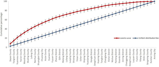
Figure 3.
Lorenz curve of traditional villages in central Dianzhong region (Figures were drawn by authors).
4.1.2. Analysis of Spatial Aggregation
Through nearest-neighbor spatial analysis Method (3), the observed mean nearest-neighbor distance among traditional villages is 9.37 km—significantly less than the expected distance of 12.90 km—yielding a nearest-neighbor index R = 0.726 (R < 1). Combined with a Z-score of −8.292853 (p < 0.01), this confirms that the spatial distribution of traditional villages in the region follows a pronounced clustered pattern (Figure 4a).
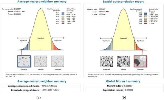
Figure 4.
Analysis of spatial aggregation. (a) Average nearest neighbor summary chart; (b) spatial autocorrelation statement chart (Maps were drawn by authors).
Based on Method (4), the Moran’s I index for the distribution of traditional villages in Central Yunnan reaches 0.681587 (with a theoretical expectation of −0.004). Since Moran’s I ranges from −1 to 1, this value indicates a strong positive spatial autocorrelation (p < 0.01). Statistical analysis shows that, with a variance of 0.005021, the Z-score is 9.675819—well above the critical threshold of 2.58 at the 99% confidence level—further substantiating the statistical significance of the clustering pattern (Figure 4b).
The consistency between these two spatial-analysis methods jointly demonstrates the clustered nature of traditional-village distribution in Central Yunnan, providing a theoretical basis for subsequent cluster identification of such villages.
4.1.3. Spatial Distribution of Traditional Villages and Their Influencing Factors
- (1)
- Relationship between Traditional Villages and Elevation
By visualizing the DEM data for the Central Yunnan region (Figure 5), the study reveals that traditional villages are predominantly situated in the mid-elevation band (1280–2045 m), accounting for 68.53% of the total. These villages occupy small plateau basins (“dam” areas), low mountain hills, and transitional river-valley zones. This elevation band enjoys a mildly warm climate and fertile soils, which facilitate diversified agricultural practices (e.g., terraced cultivation), while its relatively accessible transport conditions have further encouraged village establishment.
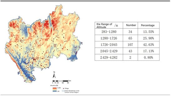
Figure 5.
Distribution of traditional villages at various altitudes (Maps were drawn by authors).
In contrast, villages at high elevations (>2429 m) and low elevations (<1280 m) are comparatively rare. The high-altitude zone (2429–4282 m) contains only 0.80% of the villages; its rugged terrain and poor connectivity severely constrain settlement growth. Low-elevation villages are primarily distributed along the arid-hot river valleys and humid-hot basin areas, such as those of the Yuanjiang, Nanpanjiang, and Jinshajiang rivers.
- (2)
- Relationship between traditional villages and slopes
In central Yunnan, the terrain is complex and steep with significant elevation differences; slope is therefore an important factor influencing the distribution and clustering of villages (Figure 6). Using the slope analysis tool in ArcGIS, the study found that gently sloping areas of 3–15% are core areas for village clustering. These areas are mainly mountainous gentle slopes or flat terraces, such as the Hani terraces in Honghe Prefecture. The typical slope of 3–15% is a main characteristic of Hani village clusters.
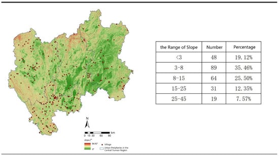
Figure 6.
Distribution of traditional villages across the range of slopes. (Maps were drawn by authors).
- (3)
- The relationship between traditional villages and slope directions
The distribution of traditional villages across different slope directions is relatively balanced, with little difference in numbers, suggesting that slope direction has a minimal impact on the spatial distribution of traditional villages (Figure 7).
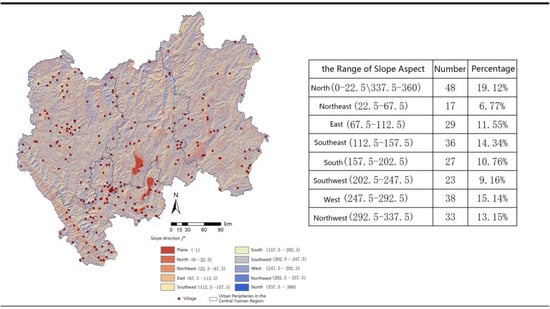
Figure 7.
Distribution of traditional villages by slope orientation (Maps were drawn by authors).
- (4)
- Relationship between traditional villages and the distribution of major rivers
Using the nearest-neighbor analysis tool in ArcGIS (Figure 8), it can be seen that the proportion of villages located 20–50 km from the river is the highest (39.44%). This area is the core distribution region of traditional villages and the principle of ‘living by the water’ is less applicable here due to the natural geographical environment of central Yunnan. Most rivers in central Yunnan flow through deep canyons with steep banks and little flat land. The area directly adjacent to the river (within 5 km) is vulnerable to floods and landslides, which makes it difficult to establish stable settlements. Additionally, water sources rely on mountain springs, groundwater and terraced water storage systems rather than direct access to the main river. This unique adaptation to the hydrological environment of the plateau mountains means that traditional villages do not form directly adjacent to the river, but rather tend to keep a certain distance from it.
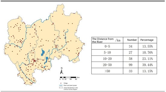
Figure 8.
Map of traditional villages in relation to distance from major rivers (Maps were drawn by authors).
4.2. Results of the Identification of Traditional Villages in the Central Yunnan Region
4.2.1. Clustering Characteristics of Traditional Villages in the Central Yunnan Region Based on a Single Factor
Spatial Proximity Clustering Characteristics
The spatial proximity clustering results (Figure 9) indicate that traditional villages in Central Yunnan exhibit a spatial pattern of “one belt–three clusters–multiple points.”
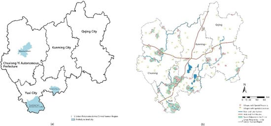
Figure 9.
Spatial proximity clustering identification results. (a) Main Aggregation Areas of Spatial Proximity Clusters; (b) spatial proximity clustering identification map. (Maps were drawn by authors.)
The “belt” extends along the Kunming-Yuxi border in a southwest-northeast trending corridor, forming a continuous agglomeration belt driven by historical post roads, with a proximity density of 0.014–0.036 villages/km2.
The “three clusters” are distributed in Yuanjiang Hani Autonomous County (southern Yuxi), Tonghai County (eastern Yuxi), and Mouding County (central Chuxiong), all featuring flat terrain and high accessibility.
The “multiple points” display insular dispersion due to fragmented topography, with all traditional village agglomeration areas exceeding a density of 0.007 villages/km2.
This spatial configuration ultimately forms 30 spatial proximity clusters, encompassing 133 traditional villages.
Geomorphic Similarity Clustering Characteristics
The results of the geomorphic similarity clustering analysis in central Yunnan revealed significant coupling characteristics between the distribution of traditional villages and watersheds, mountain orientations, and dam patterns. Using the clustering and outlier analysis method alongside three-dimensional terrain interpretation, 18 geomorphic similarity clusters and four types of geomorphic correlation clusters were identified (Figure 10).
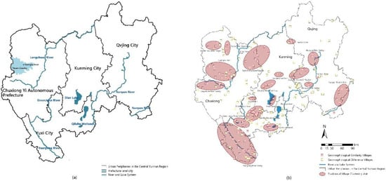
Figure 10.
Geomorphic similarity clustering identification results. (a) Primary aggregation areas of geomorphic similarity clusters and water system distribution; (b) geomorphic similarity clustering identification map (Maps were drawn by authors).
The first type is the watershed corridor, containing six clusters and 54 villages in four major watersheds: the Nanpan River, Yuanjiang River, Green Juice River and Longchuan River. Three-dimensional visualization analysis of the DEM revealed that the villages in the watershed corridor type showed a ‘bead chain’ distribution along the water system, demonstrating the linear constraints of the water system on the spatial organization of the villages.
Secondly, the flat dam area type, with a total of five clusters of flat dams, with the Guanglu Town dam area in the Chuxiong Yi Autonomous Prefecture as the representative.
Thirdly, the mountainous vertical type, distributed on slopes between 1800 and 2500 m, with a total of 54 clusters, including six clusters along the Nanpanjiang River. Five mountain clusters are located on slopes between 1800 and 2500 m;
Fourthly, the lake coastal type is mainly located in seven traditional villages along Dianchi and Qilu Hu.
Cultural Convergence Clustering Characteristics
As an area of typical multi-ethnic integration, the result of the cultural convergence clustering analysis shows a composite feature of ‘multiple superposition and corridor traction’. Through spatial autocorrelation analysis using ArcGIS and a coupling model of cultural and geographical factors, four types of cultural convergence cluster were identified (Figure 11), covering 96 traditional villages.
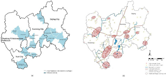
Figure 11.
Cultural convergence clustering identification results. (a) Primary aggregation areas of cultural convergence clusters; (b) cultural convergence clustering identification map (Maps were drawn by authors).
Firstly, there are ethnic symbiotic clusters. These are mainly located in areas inhabited by the Yi ethnic minority, such as Tonghai County and Yuanjiang Hani and Yi Dai Autonomous County in Yuxi City, Luoping County in Qujing City and Muding County in the Chuxiong Yi Autonomous Prefecture. These areas form a cultural circle shared by multiple ethnic groups, centered on intangible cultural heritage such as the Yi Bimo culture and the Torch Festival.
Secondly, there are the ancient road-dependent clusters. Along the Southern Silk Road (Central Yunnan) and the Yunnan-Tibet Tea and Horse Road, a linear cultural corridor has formed identifying four major sub-clusters: Wuhua-Xishan (Kunming City); Lufeng-Chuxiong (Chuxiong Yi Autonomous Prefecture); Jinning-Eshan (Yuxi City); and Yiliang-Malong (Qujing City). These areas still have horse gangs, post stations and ancient paved roads. These areas have retained material evidence of horse gangs and ancient road paving stones, constituting a unique ‘ancient road-village’ symbiosis system.
Thirdly, there are farming culture clusters. In the agricultural core areas of Kunming, Dongchuan, Luliang, Damzi and Yuanjiang, local villagers have continued the traditional method of planting rice, forming a characteristic cultural cluster centered on farmland.
Fourthly, there are clusters derived from trade. Discrete cultural clusters have formed around historical horse gang trade nodes, such as Yuezhou Town in Qujing City and Lufeng County in Chuxiong. These clusters have developed unique regional identifiers, including salt wells and ancient tree tea culture.
Notably, spatial autocorrelation analysis reveals that outliers account for approximately 61.8%, indicating cultural discrepancies in villages surrounding emerging towns and underscoring the urgency of preserving cultural heritage.
Features of Building Isomorphism Clustering
Traditional villages in central Yunnan show deep synergies between their building forms and geographic environments and ethnic cultures, forming four types of differentiated clusters. Based on the 251 samples of building forms and related research, the residential types in the central Yunnan region are divided into four major categories: the courtyard system, the Qionglong system dominated by Yi palm houses, the Ganlan system dominated by footstools, and the Han-style one-printed courtyard system (Figure 12).
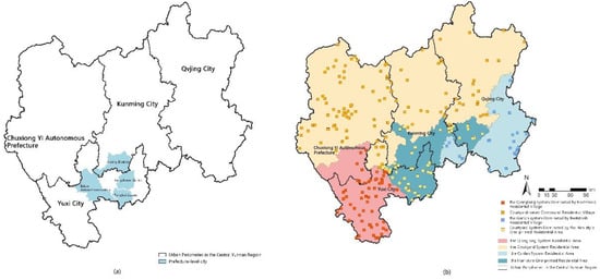
Figure 12.
Constructional isomorphism clustering identification results. (a) Primary aggregation areas of constructional isomorphism clusters; (b) constructional isomorphism clustering identification map (Maps were drawn by authors).
The Qionglong system of earth palm house clusters are concentrated in the southern part of the Chuxiong Yi Autonomous Prefecture and the southwestern part of the city of Yuxi, mainly involving Yi settlements, which are characterized by rammed-earth walls and flat roofs with stacked platforms [42]. The cluster of footstools of the Ganlan system is mainly distributed in the villages inhabited by the Miao and Dai ethnic groups, and their building elevations are mostly located in the 800–1500 m range, with a ground floor elevation rate of 92.3%, which effectively adapts to the terrain of steep slopes of more than 30°. The Han-style one-printed houses form discrete clusters in the Kunming area, especially in Jinning and Eshan on the south side of Dianchi Pond, where the distribution density is the highest. The courtyard system is concentrated in the Tonghai-Jiangchuan dam area, and its “six contract spring” plan expansion mode and the “one seal” form an obvious morphological difference, which confirms the architectural and cultural dissemination fault under the influence of the Ming Dynasty’s military system. In conclusion, the residential clusters do not exist in isolation, and their distribution pattern is driven by the triple driving force of “topography-culture-history path”, such as the locking relationship between the earth palm houses and the dry and hot river valley, and the vertical response between the hanging footstools and the steeply sloping mountains, which reveals the synergistic evolution of multi-ethnic settlements of “geography and culture-humanities” in central Yunnan. “This reveals the resilience mechanism of the synergistic evolution of multi-ethnic settlements in central Yunnan.
4.2.2. Characteristics of Traditional Villages in the Central Yunnan Region
Through systematic synthesis, Central Yunnan’s traditional villages form four Comprehensive-Integrated Type clusters (47 villages), three Feature-Dominated Type clusters (51 villages), and one Potential-Cultivating-Type cluster (102 villages). An additional 51 villages exhibit no significant clustering, with detailed results presented in Table 5 and Figure 13.

Table 5.
Final integrated clustering identification results. Table was drawn by authors.
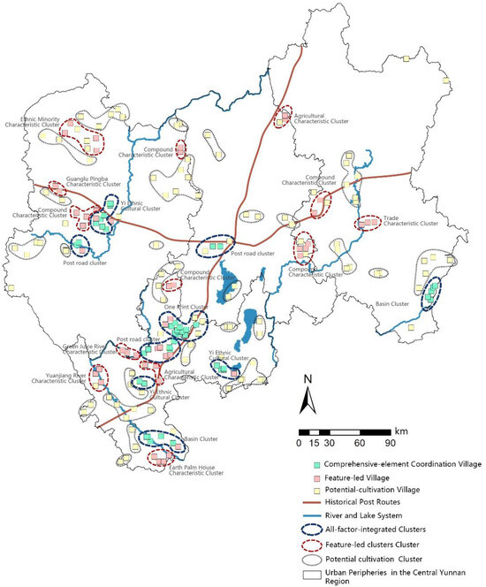
Figure 13.
Final integrated clustering identification map (Maps made by authors).
Overall, traditional villages in Central Yunnan demonstrate relatively concentrated dominant clusters and extensively distributed potential resources (Figure 13). Comprehensive-Integrated Type and Feature-Dominated-Type clusters collectively account for 36.7% of the total, predominantly distributed along rivers and historical post roads in belt-shaped patterns with strong spatial concentration. Potential-Cultivating-Type clusters constitute 40.6% of the total; despite their dispersed distribution, they form localized groupings indicating residual spatial connectivity. Non-clustered traditional villages (22.7% of the total) are constrained by natural conditions and urbanization impacts, sporadically distributed along mountainous fringes and areas with poor transportation accessibility.
Characterization of All-Factor-Integrated Clusters
Based on the characteristics of Central Yunnan, the Comprehensive-Integrated Type clusters are subdivided into watershed clusters, post-road clusters, Yikeyin clusters, and Yi cultural clusters (Table 5). Traditional village clusters exhibit hierarchical nesting attributes in spatial distribution, with primary clusters often generating multiple secondary units [43]. Due to prominent spatial heterogeneity in Central Yunnan, the four primary cluster types derive seven secondary units.
First, watershed clusters. Distributed along the main water systems of Yuanjiang and Nanpanjiang rivers, these include the Nanpanjiang Cluster and Yuanjiang Cluster. They form belt-shaped settlement systems leveraging river valley basins and shipping networks (Figure 14).
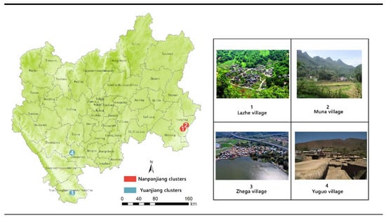
Figure 14.
Representative traditional villages in watershed clusters. (maps made by authors; figure source: (1) https://www.cuanwang.cn/vip_doc/25688002.html (accessed on 22 April 2025); (2) https://baike.baidu.com/item/%E6%9C%A8%E7%B4%8D%E6%9D%91/5671920 (accessed on 22 April 2025); (3) https://www.sohu.com/a/523233497_121119240 (accessed on 22 April 2025); (4) https://www.sohu.com/a/133996649_692814 (accessed on 22 April 2025).
- (1)
- The Nanpanjiang River, as the primary source of the Pearl River, historically served as a crucial waterway and cultural corridor linking Yunnan, Guizhou, and Guangxi. Its narrow valley features significant elevation differences between the river and flanking mountains. Villages predominantly occupy river terraces or basin areas, aligning with the watercourse. Development here reflects influences from shipping trade and multi-ethnic integration, blending commercial culture, Dai water culture, and Han agricultural traditions. The cluster primarily features stilt-house dwellings (Figure 15a) with elevated living quarters above flood-prone ground floors, facilitating moisture control and cargo handling.
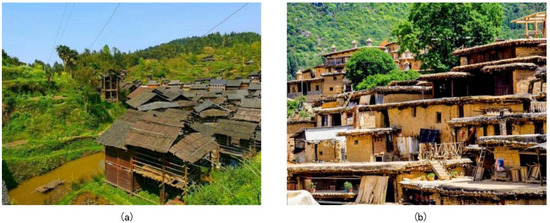 Figure 15. Representative Traditional Vernacular Dwellings. (a) Stilt-house dwelling, source: https://k.sina.com.cn/article_5613718761_p14e9a8ce9027006ayr.html (accessed on 22 April 2025); (b) Rammed earth flat-roof house, source: https://www.sohu.com/picture/448059189 (accessed on 22 April 2025).
 - (2)
- The Yuanjiang Basin lies within Central Yunnan’s dry-hot valleys, characterized by alternating alluvial plains and mountainous gorges. Villages adopt spot-belt distributions along river terraces or piedmont highlands. Historically a nexus for ethnic migration and garrison settlements, it exhibits prominent multi-ethnic cohabitation and cultural inter-embedding. Vernacular architecture here is typified by Qionglong-style rammed earth flat-roof houses (Figure 15b), featuring compacted earth walls and soil-covered roofs for thermal regulation. Together, these clusters embody the developmental logic of “water-driven prosperity and ethnic integration”, demonstrating the fusion of spatial, geomorphic, cultural, and constructional dimensions under hydrological influences.
Second, the Post Road Cluster. The Central Yunnan Post Road Cluster developed along historical arteries like the Ancient Tea Horse Road and the Yunnan-Myanmar Corridor, exhibiting a chain-like structure characterized by “strategic passes + post-house villages”. Its historical lineage traces back to the military and administrative needs of the central governments during the Tang and Song dynasties for consolidating control over the southwest. The study identifies two major sub-clusters: the Southern Yunnan Official Horse Road Cluster and the Yunnan-Tibet Tea Horse Road Cluster (Figure 16).
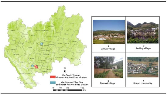
Figure 16.
Representative traditional villages in post-road clusters. Maps were drawn by authors; images source: (1) https://baike.baidu.com/item/%E6%A0%96%E6%9C%A8%E5%A2%80%E6%9D%91 (accessed on 22 April 2025); (2) https://zhuanlan.zhihu.com/p/53434580 (accessed on 22 April 2025); (3) https://sf-item.taobao.com/sf_item/674617551071.htm (accessed on 22 April 2025); (4) https://baike.so.com/gallery/list?ghid=first&pic_idx=1&eid=6303036&sid=24822188 (accessed on 22 April 2025).
Topographically, the post roads predominantly followed mountain valleys, river courses, or mountain passes. Village siting and layout adapted to the narrow, elongated terrain and significant elevation changes, resulting in a linear distribution pattern.
Culturally, the cluster villages embody historical memories of commercial exchange, caravan culture, and multi-ethnic integration. Distinct features include the tea-horse trade, the postal relay station system, and the interwoven lifestyles of diverse ethnic groups.
Architecturally, the building complexes primarily consist of enclosed courtyard dwellings. Representative typologies include the “Three-Winged House with Screen Wall” (Sanfang Yizhaobi) and the “Quadrangle with Five Courtyards” (Sihe Wutianjing). Structures feature thick rammed earth walls with defensive elements like arrow slits and observation ports integrated into gate walls. Gable roofs were commonly employed to minimize wind resistance. The longitudinal row-house layout was well-suited to the constricted terrain and met the temporary lodging needs of traveling merchants.
Extant features within the Post Road Cluster include preserved stone-paved sections of the ancient roads and beacon tower ruins. These elements demonstrate a multidimensional coupling of spatial organization, topography, culture, and construction techniques. Collectively, the cluster stands as a living testament to the history of frontier transportation and multi-ethnic interaction in the region.
Third, Yikeyin clusters. The Yikeyin clusters represent quintessential Han immigrant culture in Central Yunnan, tracing back to the Ming Dynasty’s garrison settlement policies. To stabilize the frontier, Han military-civilian populations constructed fortified villages along the Kunming-Yuxi basin plains, forming settlement systems centered on “military-household nuclei with integrated farming-defense.” Hulong Village (Qing Dynasty), for instance, expanded outward from a central fort, with extant granaries and watermills attesting to its historical “militia-farming integration” logic.
Spatially and geomorphologically, villages interlock with terraced fields and water networks, achieving high adaptability through a tri-level “courtyard-alley-field” system that integrates defense, habitation, and agriculture. This configuration remains a living specimen for studying Ming-Qing frontier governance and multi-ethnic architectural fusion (Figure 17).
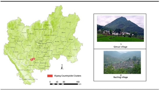
Figure 17.
Representative traditional villages in Yikeyin clusters. Maps were drawn by authors; images were sourced from the Internet (1) https://www.sohu.com/a/154721161_825382 (accessed on 22 April 2025); (2) https://baike.baidu.com/item/%E6%9C%A8%E9%B2%8A%E6%9D%91/9793879 (accessed on 22 April 2025).
Culturally and architecturally, clusters feature square enclosed courtyards as basic units—resembling seal stamps—with main halls (three-bay two-story structures) centrally positioned, flanked by symmetrical side wings and entrance porches in reversely set wings. This forms enclosed “quadrangle courtyards with inward-sloping roofs” (*sishuiguitang*). Structures predominantly employ Han-style flush gable roofs, while decorative elements like carved door headers and six-paneled doors incorporate Yi “beam-top tiger-head paintings”, manifesting distinctive Yi-Han symbiotic regional culture.
Fourth, Yi cultural clusters. The Yi cultural clusters consist of two sub-clusters: Central-Northwest Yunnan and Central-Southwest Yunnan. Their distribution spatially coincides with the Southern Yunnan Official Horse Road and Yunnan-Tibet Tea-Horse Road, reflecting the synergy between socio-cultural drivers and geo-economic factors.
Geomorphologically, this cluster spans two typical terrains: plateau mountains and river valley basins. The Central-Northwest region predominantly features high-altitude mountainous areas where villages adopt scattered layouts following topographic contours, forming point distributions anchored to small terraces and ridgelines. In contrast, the Central-Southwest region leverages plains and basins along the Honghe-Yuanjiang valleys, with villages concentrating linearly along post-road valleys.
Culturally, the Yi patrilineal kinship-based clan system (Jiazhi), distinctive religious rituals, and linguistic intermarriage traditions significantly shape settlement patterns. Salt-tea trade and material exchanges along the Tea-Horse Road further reinforced spatial stability.
Architecturally, Yi vernacular dwellings are typified by Qionglong-style structures, engineered to withstand plateau aridity/strong sunlight and valley heat. Collectively, these clusters form settlement systems integrating traditional kinship organization with commercial-post-road characteristics (Figure 18).
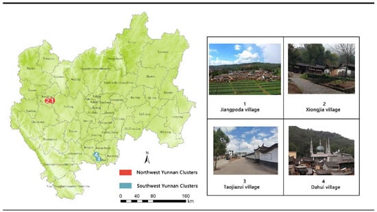
Figure 18.
Representative traditional villages in Yi cultural clusters. Maps were drawn by authors; images were sourced from the Internet: (1) https://www.mdx.gov.cn/info/1040/44046.htm (accessed on 22 April 2025); (2) https://baike.baidu.com/item/%E7%86%8A%E5%AE%B6%E6%9D%91/39346 (accessed on 22 April 2025); (3) https://nync.yn.gov.cn/html/2022/nongcunrenjuhuanjingzhengzhi_0805/389063.html (accessed on 22 April 2025); (4) https://baike.baidu.com/item/%E5%A4%A7%E5%9B%9E%E6%9D%91/50307 (accessed on 22 April 2025).
Characterization of Feature-Dominant Clusters
The Feature-Dominated-Type settlement clusters of Central Yunnan’s traditional villages are categorized into spatial, vernacular dwelling, and cultural types (Figure 19). Secondary clustering analysis further identified eight sub-units encompassing 51 traditional villages.
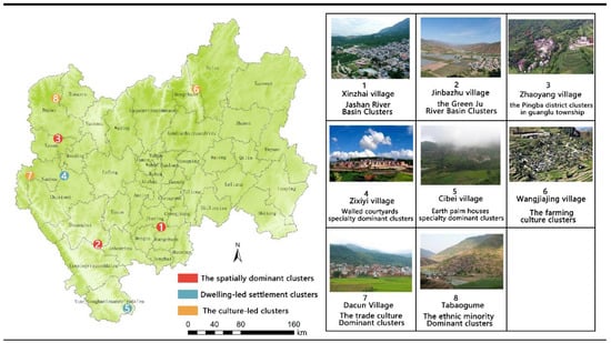
Figure 19.
Representative traditional villages in Feature-Dominated-Type clusters. Maps were drawn by authors; images were sourced from the Internet: (1) https://www.ctnews.com.cn/xiangcun/content/2024-09/23/content_165191.html (accessed on 22 April 2025); (2) https://www.douban.com/note/760939810/?_i=5334286uQ2j3l5 (accessed on 22 April 2025); (3) https://dp.pconline.com.cn/photo/list_5125919.html (accessed on 22 April 2025); (4) https://www.cxs.gov.cn/info/1012/90275.htm (accessed on 22 April 2025); (5) https://baike.baidu.com/item/%E9%82%91%E6%85%88%E7%A2%91%E6%9D%91/10426700 (accessed on 22 April 2025); (6) https://www.sohu.com/a/360518229_115092 (accessed on 22 April 2025); (7) https://baike.baidu.com/item/%E5%A4%A7%E6%9D%91/9529 (accessed on 22 April 2025); (8) https://www.sohu.com/a/281197217_99970607 (accessed on 22 April 2025).
- (1)
- First, spatially dominated clusters include the Jiasa River Basin Cluster, Lüzhi River Basin Cluster, and Guanglu Town Basin Cluster. Traditional villages in these areas form compact belt-shaped or clustered distributions along water systems, exhibiting strong spatial connectivity and distinct geographic concentration. The Jiasa River Basin Cluster is located in Yuanjiang Hani, Yi, and Dai Autonomous County; the Lüzhi River Basin Cluster in Eshan Yi Autonomous County; and the Guanglu Town Basin Cluster in Yao’an County, Chuxiong Yi Autonomous Prefecture. Vernacular dwellings predominantly feature rammed earth flat-roof houses adapted to local topography and climate, reflecting significant environmental influences on architectural forms.
- (2)
- Second, vernacular dwelling-dominated clusters are subdivided into courtyard-style and rammed earth flat-roof house types. The former concentrates along Central Yunnan’s ancient post roads, characterized by Han-style “Yikeyin” configurations, where architectural ensembles and caravan posthouse remnants collectively form “trade-architecture” composite landscapes. The latter primarily occupies the western Yuanjiang Basin (southern Yuanjiang Hani, Yi, and Dai Autonomous County), representing a core distribution area of Qionglong-style rammed earth houses. Their thick-walled, flat-roof structures demonstrate regional adaptability to dry-hot valley climates.
- (3)
- Third, culturally dominated clusters comprise agricultural culture clusters, trade culture clusters, and ethnic minority clusters. Agricultural culture clusters distribute across western Eshan Yi Autonomous County and eastern Dongchuan District, Kunming, preserving traditional farming systems with village layouts closely aligned with agricultural patterns. Trade culture clusters focus in central Qilin District, Qujing, distinguished by ancient ceramic kiln culture. Historically formed through prosperous kiln trade, they exhibit settlement patterns interweaving workshops, marketplaces, and residences; compact courtyard layouts primarily feature enclosed quadrangle dwellings integrating habitation and artisanal production, fully reflecting trade activities’ profound impact on spatial morphology and social structure. Ethnic minority clusters locate at the border of Dayao and Yong’an counties, predominantly Yi traditional villages. Their dwellings incorporate vibrant ethnic motifs and patterns based on enclosed quadrangle frameworks, demonstrating distinctive cultural representation in architectural forms.
Characterization of Potential Cultivation-Type Clusters
Potential-Cultivating-Type clusters are characterized by single or dual-element agglomeration. Compared to the multidimensional synergy of Comprehensive-Integrated Type clusters and the prominent advantages of Feature-Dominated-Type clusters, these clusters exhibit deficiencies in spatial, cultural, or constructional dimensions, resulting in weaker overall integration and connectivity. This type encompasses 102 traditional villages, primarily distributed in Yuxi City, northern Chuxiong Yi Autonomous Prefecture, and southern Qujing City. Constrained by complex mountainous topography such as fault basins and vertical river valleys, they form a “scattered-point” distribution pattern.
Although lacking high-density spatial agglomeration or complete cultural systems, these villages generally retain locally distinctive cultural genes and living intangible heritage resources—such as Yi Bimo ritual ceremonies and Southern Yunnan Huadeng opera—providing unique potential for future cultural exploration and differentiated development. Their dwelling forms are diverse but lack unified iconic features; some villages preserve traditional enclosed or quadrangle layouts, offering foundational conditions for cultivating constructional distinctiveness.
For example, Yongjia Village in Qujing (a nationally recognized traditional village), though geographically isolated, maintains 37 intact enclosed quadrangle complexes built between the Qianlong and Guangxu reigns of the Qing Dynasty. Courtyards are organically connected via eaves galleries, alleys, and intermediate halls, forming a clan settlement pattern of “household independence with courtyard interconnectivity.” Such villages demonstrate that while Potential-Cultivating-Type clusters lack comprehensive advantages across spatial, geomorphic, cultural, and constructional dimensions, systematic enhancement of dominant elements and functional supplementation can enable their transformation into Feature-Dominated or even Comprehensive-Integrated clusters, highlighting significant developmental potential and conservation value.
5. Discussion
This study systematically analyzes the spatial distribution patterns and clustering patterns of traditional villages in central Yunnan through the four-dimensional system of “space-geomorphology-culture-construction”.
In terms of spatial distribution, the traditional villages in central Yunnan are characterized by a significant uneven distribution, mainly clustered in the gently sloping areas at mid-altitude, and are significantly influenced by river corridors and historical post routes. This finding is consistent with the conclusion from the study of traditional villages in Southwest China, that is, mountain villages are mostly distributed in the transition zone with gentle topography and abundant resources, and balance production and ecological needs through adaptive strategies [44]. Unlike the typical pattern of “living by water” in the plains, the villages in central Yunnan showed an “indirect” dependence on rivers, with 39.44% of the villages located 20–50 km away from rivers, which is different from the typical pattern of “living by water” found in coastal areas. This contrasts with the hydrological adaptation pattern of villages found in coastal areas [45], which highlights the role of the unique “forest-terraces-water system” complex water storage system in the plateau mountainous environment in driving the location of villages.
The results of single-cluster differentiation reflect the unique characteristics of the central Yunnan cluster.
- (1)
- In terms of spatial and geomorphological features, the villages in central Yunnan exhibit a composite feature of ‘belt + cluster’, which differs from the ‘one-center-multiple-point’ result of analyses by Hong Tingting and other researchers [35]. This difference stems from the ‘valley effect’ in the distribution of villages in the mountainous highland environment: villages form linear agglomerations along the deep valleys of the Jinsha and Yuanjiang rivers, whereas the Zhangzhou Coastal Plain exhibits a faceted expansion pattern. The study confirms that the geographic environment significantly influences the selection of traditional methods for identifying village clusters.
- (2)
- In terms of cultural mechanisms, the two dominant modes of ‘ancient road dependence’ and ‘ethnic symbiosis’ in central Yunnan reflect a unique cultural and economic driving force. Their spatial distribution is closely related to the history of the intermingling of Han and Yi cultures, and to the salt and tea trade. This is a phenomenon that is rarely seen in studies of traditional villages in East Asia. This feature is uncommon in studies of traditional East Asian villages. As a hub of the Southern Silk Road, the linear cultural corridors formed by the horse-gang trade in Central Yunnan demonstrate significant spatial continuity. In contrast, the coastal villages of Zhangzhou formed discrete cultural clusters through harbor trade. This corroborates the idea that inland mountain culture transmission relies on linear corridors, whereas coastal areas are more likely to form networked cultural associations [44]. This finding echoes Hong Tingting et al.’s findings in the Fujian Tulou cluster but adds a new dimension to the interpretation of cluster formation through inter-ethnic trade networks [35]. However, the anomalous cultural homogeneity rate of 61.8% exposes the crisis of cultural fragmentation in marginalized urbanized areas, revealing the current situation of villages being abandoned and highlighting the urgent need for precise intervention.
- (3)
- In terms of building characteristics, the unique vertical adaptation system of the ‘Qionglong–Ganlan system’ in central Yunnan has been identified. Its three-dimensional spatial organization contrasts with the horizontal expansion pattern of the ‘Huilou–Paihu system’ in Zhangzhou, showcasing the contrasting wisdom of eastern and western architecture. Notably, the Han-style ‘one seal’ dwellings formed distinct clusters in Kunming City, confirming the influence of the Ming dynasty’s military system on central Yunnan’s architectural culture. This provides a new empirical basis for the ‘cultural superposition’ theory in historical geography.
In terms of overall cluster identification, this study proposes the following categorization framework: ‘total factor-integrated’, ‘feature-dominated’ and ‘potential-cultivated’. All-factor-integrated clusters demonstrate a high level of synergy in terms of space, culture, geomorphology, and construction. This finding is consistent with the results of a study on the spatial heterogeneity and formation mechanism of ethnic minority villages in the Yangtze River Basin [46]. Environmental adaptability and the long-standing concept of human–land coordination contribute to the formation of the regional village network [47]. This suggests that the heterogeneity of village clusters in complex geographic environments should be analyzed by differentiating multidimensional combinations of factors.
The hierarchical superposition model effectively reveals the intrinsic complexity of multi-ethnic settlements in the mountains of central Yunnan. Linear river valleys and ancient roads acted as historical ‘connecting corridors’, overcoming topographic barriers and facilitating cultural intermingling—a finding that supports Hu’s theory of landscape genetic mapping [20] and challenges the traditional notion of ‘isolated evolution’ in Yunnan’s ethnic areas. This finding also challenges the traditional assumption that Yunnan’s ethnic areas evolved in isolation, as proposed by Hu’s theory of landscape genetic mapping. Compared with established international studies, the clustering characteristics of traditional villages in central Yunnan reflect universal laws as well as highlighting regional particularities.
6. Conclusions
Traditional villages in Central Yunnan demonstrate distinctive global characteristics through their complex plateau geography, unique multi-ethnic symbiotic culture, historically trade-corridor-driven spatial patterns, and vertically adaptive construction systems. Findings reveal villages predominantly concentrate in mid-elevation gentle-slope zones, forming a “belt–cluster–scatter” distribution pattern along river valleys and ancient post roads, exhibiting mountain-adapted “indirect hydrophilicity” logic. Synergistic interactions among ethnic customs, trade networks, and terrain further shape diverse vernacular systems like rammed earth flat-roof houses and stilt dwellings, reflecting settlement evolution driven by historical institutions and regional culture.
Compared to conventional “inventory-based” protection and isolated restoration approaches, the proposed cluster identification model transcends administrative boundaries and management units, enhancing conservation integrity and precision. For example, the four identified Comprehensive-Integrated Type clusters exhibit high consistency across spatial, geomorphic, cultural, and constructional dimensions, providing foundational conditions for contiguous conservation and integrated development. These qualify for priority inclusion in national/provincial contiguous conservation demonstration zones, achieving cross-regional coordination through holistic restoration, landscape corridor construction, and cultural route regeneration.
Conversely, Feature-Dominated and Potential-Cultivating-Type clusters require tailored spatial conservation strategies aligned with their dominant elements. Cultural-dominant clusters may leverage existing cultural resources and policy platforms to strengthen cultural cores and sustainable vitality through intangible heritage transmission spaces, interconnected cultural landscape routes, and community-led preservation mechanisms. Potential-Cultivating clusters could progressively cultivate conservation value under rural revitalization frameworks via traditional architecture restoration, industrial guidance, and community participation.
Mapping cluster identification outcomes onto territorial spatial planning, historic town conservation schemes, and rural revitalization policies enables establishing a “spatial unit–functional zoning–policy instrument” trinity conservation system, transitioning from fragmented restoration to integrated cluster protection.
This study comprehensively analyzes the spatial distribution and clustering characteristics of Central Yunnan’s traditional villages, proposing a pathway for contiguous typological conservation of multi-ethnic mountain settlements. Limitations include
- (1)
- Geographically constrained research scope;
- (2)
- Insufficient consideration of socio-economic variables in clustering;
- (3)
- Cultural analysis reliance on historical documents with inadequate quantification of implicit cultural genes;
- (4)
- Partial capture of villages’ temporal dynamics.
Future research should expand geographical coverage, conduct precise quantitative analyses with enhanced datasets, establish comprehensive indicator systems to investigate spatial-cluster differentiation drivers, and incorporate qualitative studies on villagers, policies, and cultural identity to analyze historical layering effects on cluster morphology, thereby enriching temporal dimensions of regional cultural landscape conservation.
Author Contributions
Conceptualization, T.C.; methodology, S.Z.; software, S.Z.; validation, S.Z. and J.C.; formal analysis, J.D.; investigation, Y.Z.; data curation, S.Z. and T.C.; writing—original draft preparation, S.Z., J.C., J.D.; writing—review and editing, T.C., S.Z., Y.Y.; funding acquisition, T.C.; supervision, Y.Y. All authors have read and agreed to the published version of the manuscript.
Funding
This research was funded by Office of Philosophy and Social Sciences, Yunnan Province (Grant No. YB2023090). Yunnan Provincial Basic Research Program (Grant No. 202501AT070217); Scientific Research Fund of Yunnan Provincial Department of Education (Grant No. 2025J0017); Yunnan University Education and Teaching Reform Research (Grant No. 2023Y43); Yunnan Province Xingdian Talent Support Program—Young Talent Special Project (Grant No. XDYC-QNRC-2024-366).
Data Availability Statement
The data used in this study are publicly available from authoritative Chinese governmental platforms and open-access geographic databases. These include administrative boundaries, village listings, ethnic and cultural settlement data, topographic information, and hydrological features. All datasets were obtained from official sources and open-access repositories, and are available for academic research purposes upon request or direct download from the respective platforms.
Acknowledgments
We sincerely acknowledge Baojie HE from Chongqing University and Wei XUE from Jianghan University for their kind recommendations of this Journal. We are grateful to The Fifth International Conference on Urban Climate and Urban Design for facilitating this valuable academic exchange. We also extend our gratitude to the contributing students and researchers from Yunnan University who were not included in the author list.
Conflicts of Interest
The authors declare no conflicts of interest.
References
- Li, X.; Li, Z. Delineation of traditional village boundaries: The case of Haishangqiao village in the Yiluo River Basin, China. PLoS ONE 2022, 17, e0279042. [Google Scholar] [CrossRef]
- Hu, Z.; Liu, P.L.; Tan, M. Cultural landscape genome maps: A scientific language perspective of traditional settlements. Sci. Geogr. Sin. 2024, 44, 1309–1321. [Google Scholar]
- Xue, F.; Lin, W.; Jia, Q. Exploring the reasons for the spatial mismatch between coastal intangible cultural heritage and traditional villages: Integrating intangible cultural heritage to heal mental health strategies and regain cultural identity. Medicine 2025, 104, 25–26. [Google Scholar]
- Zhao, X.; Xue, P.; Wang, F.; Qin, Y.; Duan, X.; Yang, Z. How to become one? The modern bond of traditional villages in centralized contiguous protection and utilization areas in China. Habitat Int. 2024, 145, 103018. [Google Scholar] [CrossRef]
- Gao, J.; Wu, B. Revitalizing traditional villages through rural tourism: A case study of Yuanjia Village, Shaanxi Province, China. Tour. Manag. 2017, 63, 223–233. [Google Scholar] [CrossRef]
- Liu, S.; Ge, J.; Bai, M.; Yao, M.; He, L.; Chen, M. Toward classification-based sustainable revitalization: Assessing the vitality of traditional villages. Land Use Policy 2022, 116, 106060. [Google Scholar] [CrossRef]
- Mu, Q.; Aimar, F. How are historical villages changed? A systematic literature review on European and Chinese cultural heritage preservation practices in rural areas. Land 2022, 11, 982. [Google Scholar] [CrossRef]
- Hu, L.; Dong, S.B. Characteristics of the main-body practice in rural revitalization in Japan: A case study of the flexible use of cultural heritage. Res. Agric. Mod. 2022, 43, 390–397. [Google Scholar]
- Park, Y.-N.; Lee, C.-K.; Mjelde, W.J.; Kwon, Y.-J. Policy implications of willingness to pay for sustainable development of a world agricultural heritage site: The role of stakeholders’ sustainable intelligence, support, and behavioral intention. Sustain. Dev. 2021, 30, 636–646. [Google Scholar] [CrossRef]
- Xiao, W.; Huang, E.; Li, C.; Zhang, Y.; Wang, L. Investigating the spatial distribution and influencing factors of traditional villages in Qiandongnan based on ArcGIS and geodetector. Sci. Rep. 2025, 15, 5786. [Google Scholar] [CrossRef]
- Chunla, L.; Mei, X. Characteristics and influencing factors on the hollowing of traditional villages—Taking 2,645 villages from the Chinese traditional village catalogue (Batch 5) as an example. Int. J. Environ. Res. Public Health 2021, 18, 12759. [Google Scholar] [CrossRef]
- Zhang, H.; Chen, J.; Zhou, C. Research review and prospects of traditional villages in China. City Plan. Rev. 2017, 41, 74–80. [Google Scholar]
- Pendlebury, J. The conservation of historic areas in the UK: A case study of “Grainger Town”, Newcastle upon Tyne. Cities 1999, 16, 423–433. [Google Scholar] [CrossRef]
- Lindberg, A. Residents’ attitudes towards tourism in Bigodi village, Uganda. Tour. Manag. 2006, 28, 876–885. [Google Scholar] [CrossRef]
- Dewi, L.K.Y. Modeling the relationships between tourism sustainable factor in the traditional village of Pancasari. Procedia Soc. Behav. Sci. 2014, 135, 57–63. [Google Scholar] [CrossRef]
- Bhadauria, T.; Kumar, P.; Kumar, R.; Maikhuri, R.K.; Rao, K.S.; Saxena, K.G. Earthworm populations in a traditional village landscape in Central Himalaya, India. Appl. Soil Ecol. 2012, 53, 83–93. [Google Scholar] [CrossRef]
- Palang, H.; Helmfrid, S.; Antrop, M.; Alumäe, H. Rural landscapes: Past processes and future strategies. Landsc. Urban Plan. 2003, 70, 3–8. [Google Scholar] [CrossRef]
- Stirn, M. Modeling site location patterns amongst late-prehistoric villages in the Wind River Range, Wyoming. J. Archaeol. Sci. 2014, 41, 523–532. [Google Scholar] [CrossRef]
- Kılıç, D.; Yagci, C.; Iscan, F. A GIS-based multi-criteria decision analysis approach using AHP for rural settlement site selection and eco-village design in Erzincan, Turkey. Socio-Econ. Plan. Sci. 2023, 86, 101478. [Google Scholar] [CrossRef]
- Hu, Z. Retrospects and outlooks on the research of cultural landscape gene of traditional settlements. Geogr. Geo-Inf. Sci. 2024, 40, 80–87. [Google Scholar]
- Wang, Y.; Cao, K.; Zheng, D. Study on the pattern and path of integrated protection and development of traditional villages in county areas: A case study based on Guangshan County. South Archit. 2025, 03, 62–73. [Google Scholar]
- Zhao, Q.; Ren, Y.Y. Pattern matching system of traditional village pattern ecological protection based on cluster analysis. Fresenius Environ. Bull. 2021, 30, 6509–6515. [Google Scholar]
- Xue, Q.; Huang, Y. Construction method of the concentrated contiguous protection and utilization pattern for traditional villages: An empirical study of Liangdang County, Gansu Province. Planners 2024, 40, 66–74. [Google Scholar]
- Jing, F.; Zhang, J.; Du, Y. Heritage values of ancient vernacular residences in traditional villages in Western Hunan, China: Spatial patterns and influencing factors. Build. Environ. 2020, 173, 107473. [Google Scholar] [CrossRef]
- Yu, F.; Willey, W.J.J. The evolution of human population distance to water in the USA from 1790 to 2010. Nat. Commun. 2019, 10, 430. [Google Scholar]
- Ghaderi, Z.; Henderson, C.J. Sustainable rural tourism in Iran: A perspective from Hawraman Village. Tour. Manag. Perspect. 2012, 2, 347–354. [Google Scholar] [CrossRef]
- Geertz, C. Form and variation in Balinese village structure. Am. Anthropol. 1959, 61, 991–1012. [Google Scholar] [CrossRef]
- Xiao, X.; Tang, C.; Liang, W. Spatial distribution and cultural features of traditional villages in Beijing and influencing factors. J. Resour. Ecol. 2022, 13, 1074–1086. [Google Scholar] [CrossRef]
- Shen, H.; Aziz, F.N.; Lv, X. Using 360-degree panoramic technology to explore the mechanisms underlying the influence of landscape features on visual landscape quality in traditional villages. Ecol. Inform. 2025, 86, 103036. [Google Scholar] [CrossRef]
- Sprague, D.S. Land-use configuration under traditional agriculture in the Kanto Plain, Japan: A historical GIS analysis. Int. J. Geogr. Inf. Sci. 2013, 27, 68–91. [Google Scholar] [CrossRef]
- Xu, J.; Meng, W.; Yang, W.; Lu, Z.; Xie, G.; Wang, X. Impact of transition spaces on the indoor thermal environment: A case study of traditional dwellings in Southern Shaanxi, China. J. Build. Eng. 2024, 95, 110283. [Google Scholar] [CrossRef]
- Starková, L. A Post-Anfal Village in Iraqi Kurdistan: The Remote Sensing Retrogressive analysis. Appl. Sci. 2021, 11, 4208. [Google Scholar] [CrossRef]
- Karagianni, I. Heritage policy meets community praxis: Widening conservation approaches in the traditional villages of central Greece. J. Rural Stud. 2021, 81, 47–58. [Google Scholar] [CrossRef]
- Zhang, M.; Shen, C.; Gu, W.; Ge, J.; Wang, Y.; Liu, S. Identification of traditional village aggregation areas from the perspective of historic layering: Evidence from hilly regions in Zhejiang Province, China. Land 2023, 12, 2088. [Google Scholar] [CrossRef]
- Hong, T.T.; Lai, Z.P.; Huang, X.H.; Zheng, Y. Identification and protection of traditional village clusters based on clustering analysis: A case study of Zhangzhou City. Landsc. Archit. 2023, 30, 121–129. [Google Scholar] [CrossRef]
- Renping, W.; Zhenyu, C. An ecological assessment of vernacular architecture and its embodied energy in Yunnan, China. Build. Environ. 2005, 41, 687–697. [Google Scholar] [CrossRef]
- Gao, W.; Zhuo, X.; Xiao, D. Spatial patterns, factors, and ethnic differences: A study on ethnic minority villages in Yunnan, China. Heliyon 2024, 10, e27677. [Google Scholar] [CrossRef]
- Zhang, M.; Zhu, Y.R.; Yu, T. Spatial distribution of traditional villages and the influencing factors in Qingdao. Mod. Urban Res. 2020, 12, 18–28. [Google Scholar]
- Gao, W.; Xiao, D.; Zhao, Y.; Tao, J.; Zhuo, X. Study on the cultural landscape characteristics and influencing factors of traditional villages and dwellings in Central Yunnan Region. Archit. J. 2023, S1, 194–200. [Google Scholar]
- Gao, N.; Wu, C.; Bai, K.; Ma, Y. Spatial differentiation and influencing factors of Chinese traditional villages. J. Shaanxi Norm. Univ. Nat. Sci. Ed. 2020, 48, 97–107. [Google Scholar]
- Zheng, S.; Wei, L.; Yu, H.; Kou, W. UAV imagery-based classification model for atypical traditional village landscapes and their spatial distribution pattern. Drones 2024, 8, 297. [Google Scholar] [CrossRef]
- Shao, D.; Zoh, K. Analysis of spatial distribution characteristics and driving factors of ethnic-minority villages in China using geospatial technology and statistical models. J. Mount. Sci. 2024, 21, 2770–2789. [Google Scholar] [CrossRef]
- Zhang, Y.; Han, N.; Zhang, B.; Lu, C.; Yang, M.; Zhai, F.; Li, H. Spatial and temporal distribution characteristics and evolution of traditional villages in the Qihe River Basin of China. Sci. Rep. 2025, 15, 94872. [Google Scholar] [CrossRef] [PubMed]
- Hedan, M.; Tian, Y. Spatial differentiation of traditional villages using ArcGIS and GeoDa: A case study of Southwest China. Ecol. Inform. 2021, 66, 101416. [Google Scholar]
- Lu, X.; Peng, Z.; Zhou, Y.; Xie, Y.; Chen, Z. A study on the spatial distribution characteristics and driving factors of traditional villages in the southeast coast of China: A case study of Puxian, Fujian. PLoS ONE 2024, 19, e0303746. [Google Scholar] [CrossRef] [PubMed]
- Cui, H.; Chen, X.; Chen, C.; Wang, T.; Wang, J.; Shi, D. Spatial heterogeneity and formation mechanism of ethnic groups’ villages in the Yangtze River Basin. Econ. Geogr. 2023, 43, 160–171. [Google Scholar]
- Chen, T.; Zhang, Y.; Wang, J.; Wu, B.; Yang, Y. How Does Urban Compactness Affect Green Total Factor Productivity? An Empirical Study of Urban Agglomerations in Southwest China. Sustainability 2025, 17, 6612. [Google Scholar] [CrossRef]
Disclaimer/Publisher’s Note: The statements, opinions and data contained in all publications are solely those of the individual author(s) and contributor(s) and not of MDPI and/or the editor(s). MDPI and/or the editor(s) disclaim responsibility for any injury to people or property resulting from any ideas, methods, instructions or products referred to in the content. |
© 2025 by the authors. Licensee MDPI, Basel, Switzerland. This article is an open access article distributed under the terms and conditions of the Creative Commons Attribution (CC BY) license (https://creativecommons.org/licenses/by/4.0/).