Ecological Recreation Across the Jinma Mountain Region: A Comprehensive Evaluation of Suburban Mountain Greenway Networks
Abstract
1. Introduction
2. Selection of Indicators for Evaluation
2.1. Selection of Indicators for Ecological Sensitivity
2.2. Leisure Theory and Selection of Indicators for Recreational Sub-Greenways
2.3. Selection of Indicators for Coupling Coordination Theory and Multifunctional Greenway Network
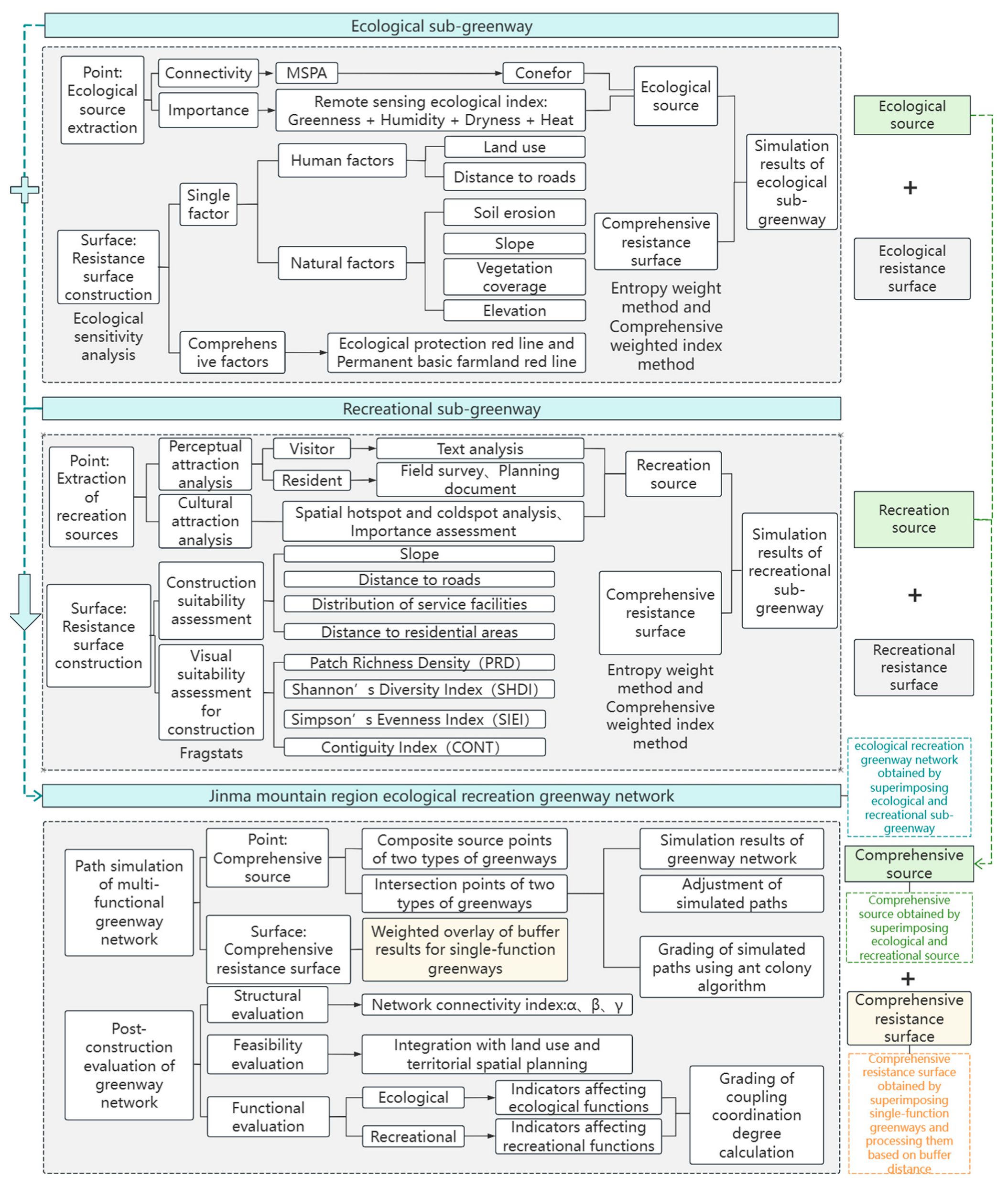
2.4. Construction of a Comprehensive Evaluation System
3. Case Study and Methods
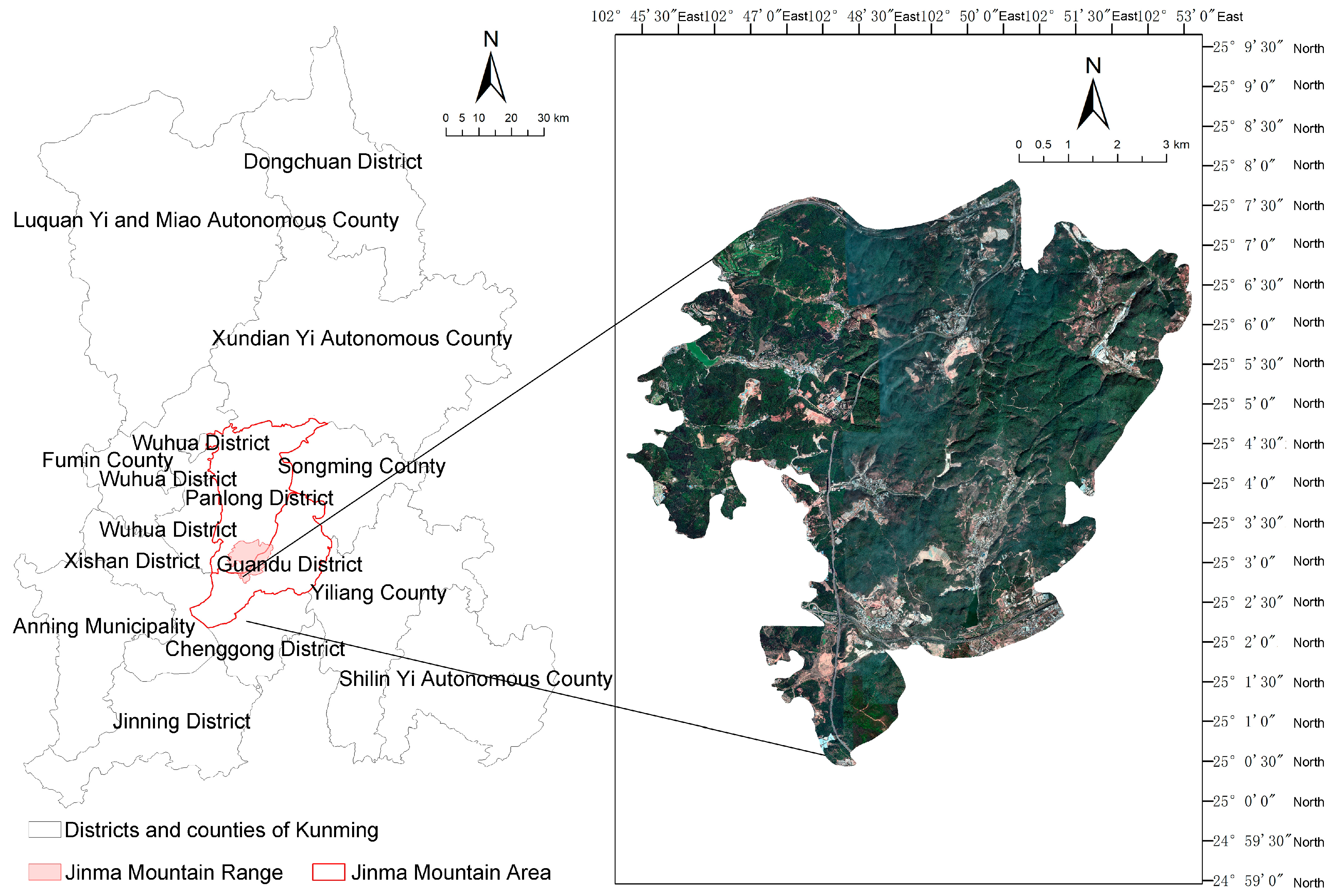
3.1. Study Site
3.2. Research Methods
3.2.1. Data Sources
- (1)
- Remote sensing imagery and elevation data: The 2021 Landsat 8 OLI_TIRS imagery of Kunming and DEM data were obtained from the Geospatial Data Cloud (https://www.gscloud.cn/), with less than 5% cloud cover.
- (2)
- Official datasets: The 2020 land use and road network data for Kunming were sourced from the Resource and Environmental Sciences and Data Center of the Chinese Academy of Sciences (https://www.resdc.cn/). Additionally, the National Science and Technology Infrastructure, National Earth System Science Data Center (http://www.geodata.cn/), provided China’s annual precipitation data (2001–2020) at a 1 km resolution, the 2018 Yunnan Province soil erodibility factor dataset at a 30 m resolution, and the 2010 China annual slope length and steepness factor dataset at a 1 km resolution. The “three lines” data for territorial spatial planning was provided by the Kunming Natural Resources and Planning Bureau and finalized in late 2022.
- (3)
- Collected data: Hiking trail data from “2 BuLu” was imported into ArcGIS 10.8 for visualization, with coordinates standardized to WGS_1984_UTM_Zone_48N.
- (4)
- Attraction review data from social platforms, including Ctrip, Weibo, and Xiaohongshu, underwent data cleaning and were analyzed using ROST_CM6. POI data were gathered from 91 Weitu locations and reclassified into categories such as public services, cultural facilities, and transportation services. Historical and cultural information was derived from national, provincial, and municipal cultural relics protection units, supplemented by field investigations to assess the importance of attractions and ensure precise spatial locations.
3.2.2. Data Calculations
- (1)
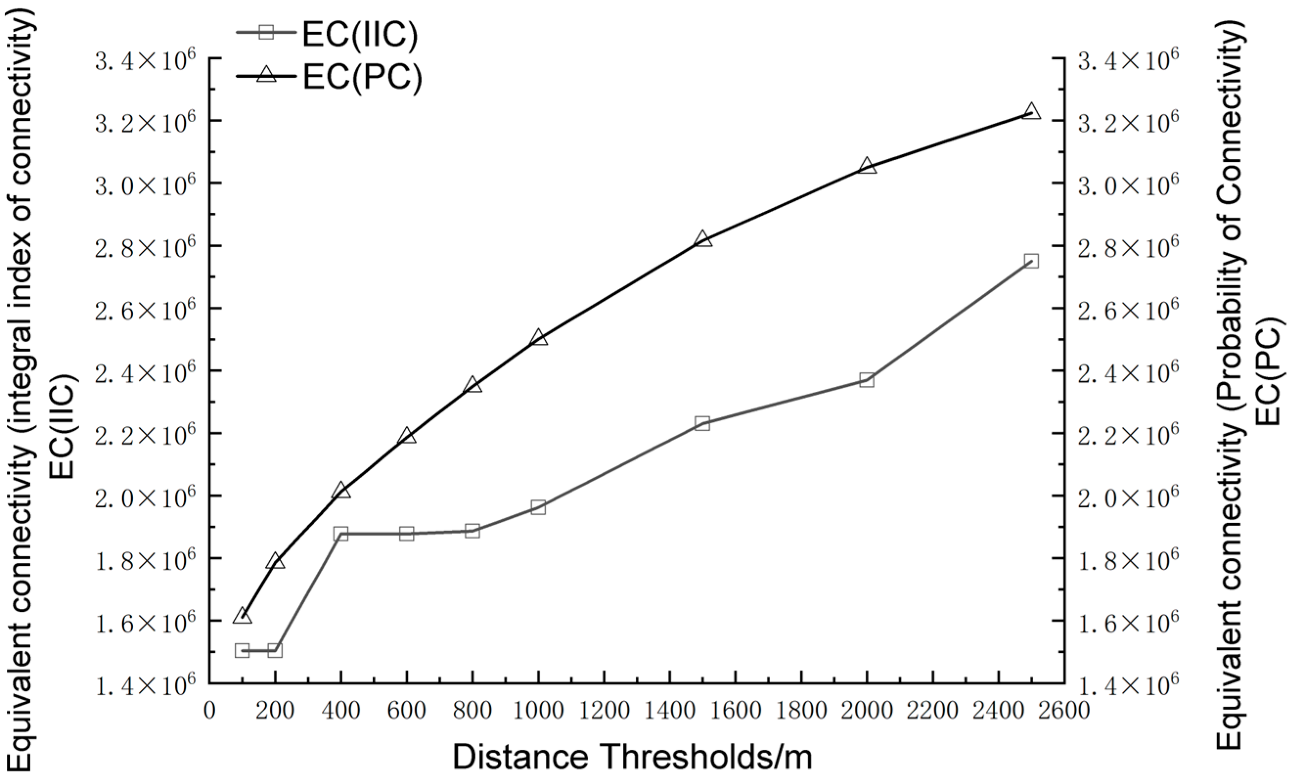
- Extraction of Source Points Utilizing the RSEI.
- (2)
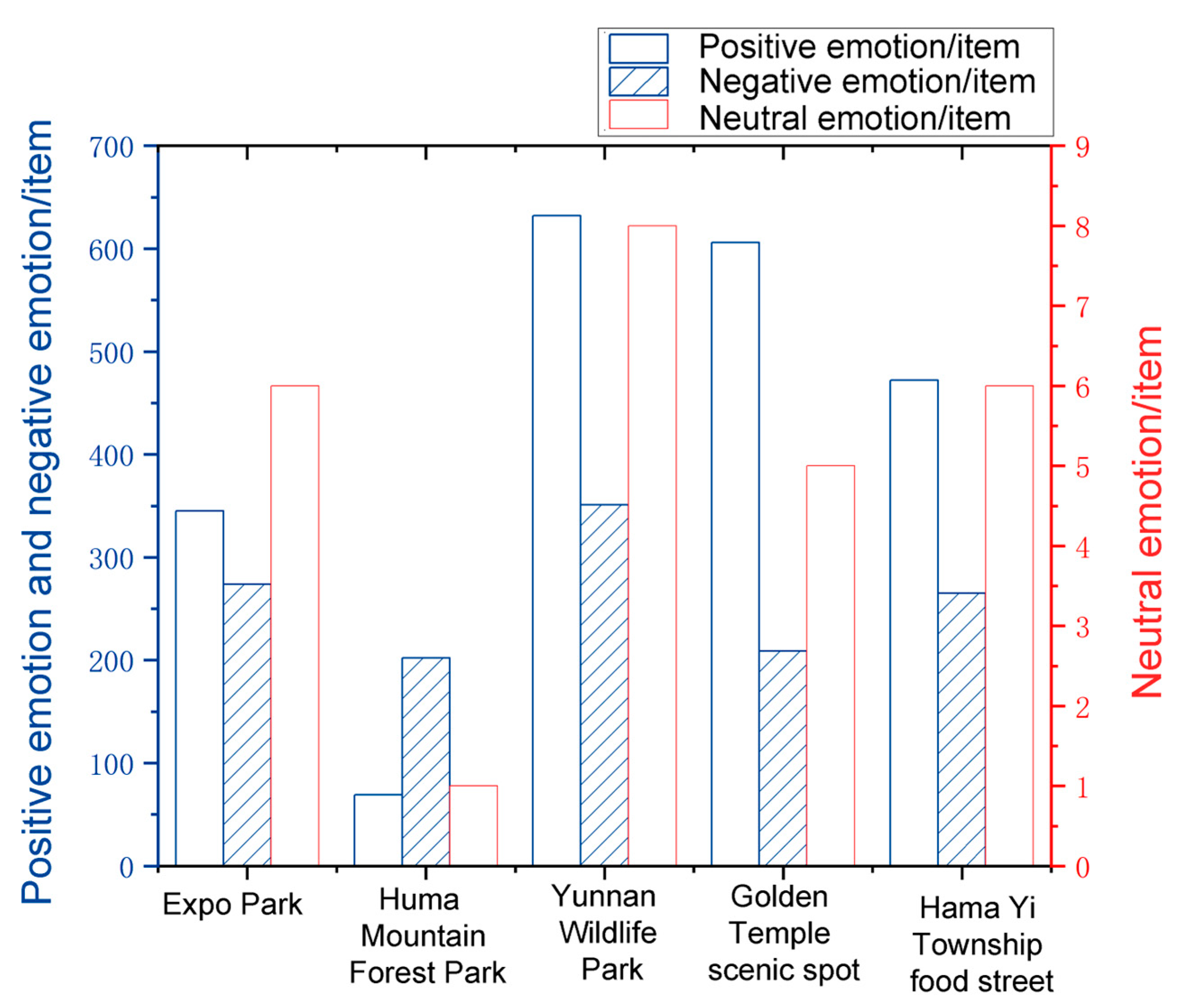
- Extraction of Source Points Based on Semantic Network Analysis.
- (a)
- Data Collection: social media evaluations were systematically mined from major Chinese platforms (Ctrip, Weibo, Xiaohongshu) using Octopus Data Collector. The primary search keywords included “Jindian Back Mountain” and related location-specific terms. Data spanned posts published during the study’s focal period (2020–2023).
- (b)
- Semantic Analysis Workflow: term extraction was carried out first, processing the cleaned corpus using ROST CM6’s word segmentation module. Then a domain-specific lexicon was compiled, including local toponyms, followed by network construction, in which co-occurrence matrices with a default window size (ROST CM6 standard) were generated and undirected semantic networks were built based on term associations. Finally, core node identification was carried out with the selection of high-frequency terms significantly associated with recreational preferences and the prioritization of nodes exhibiting both lexical centrality and landscape relevance.
- (3)
- Ant Colony Algorithm for Path Classification and Optimization.
- (4)
- Functional Evaluation of Paths Based on Coupling Coordination Degree Simulation.
4. Simulation of Jinma Mountain Greenway Network Paths
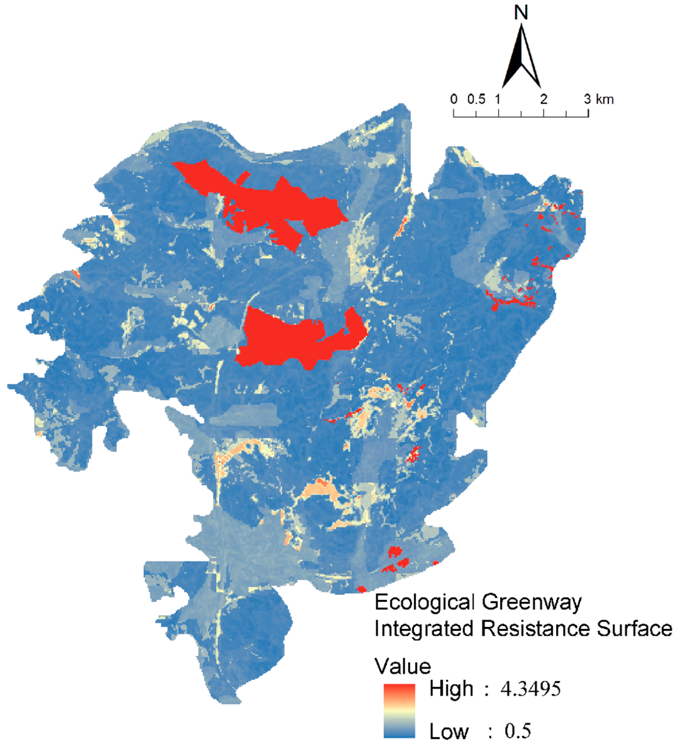
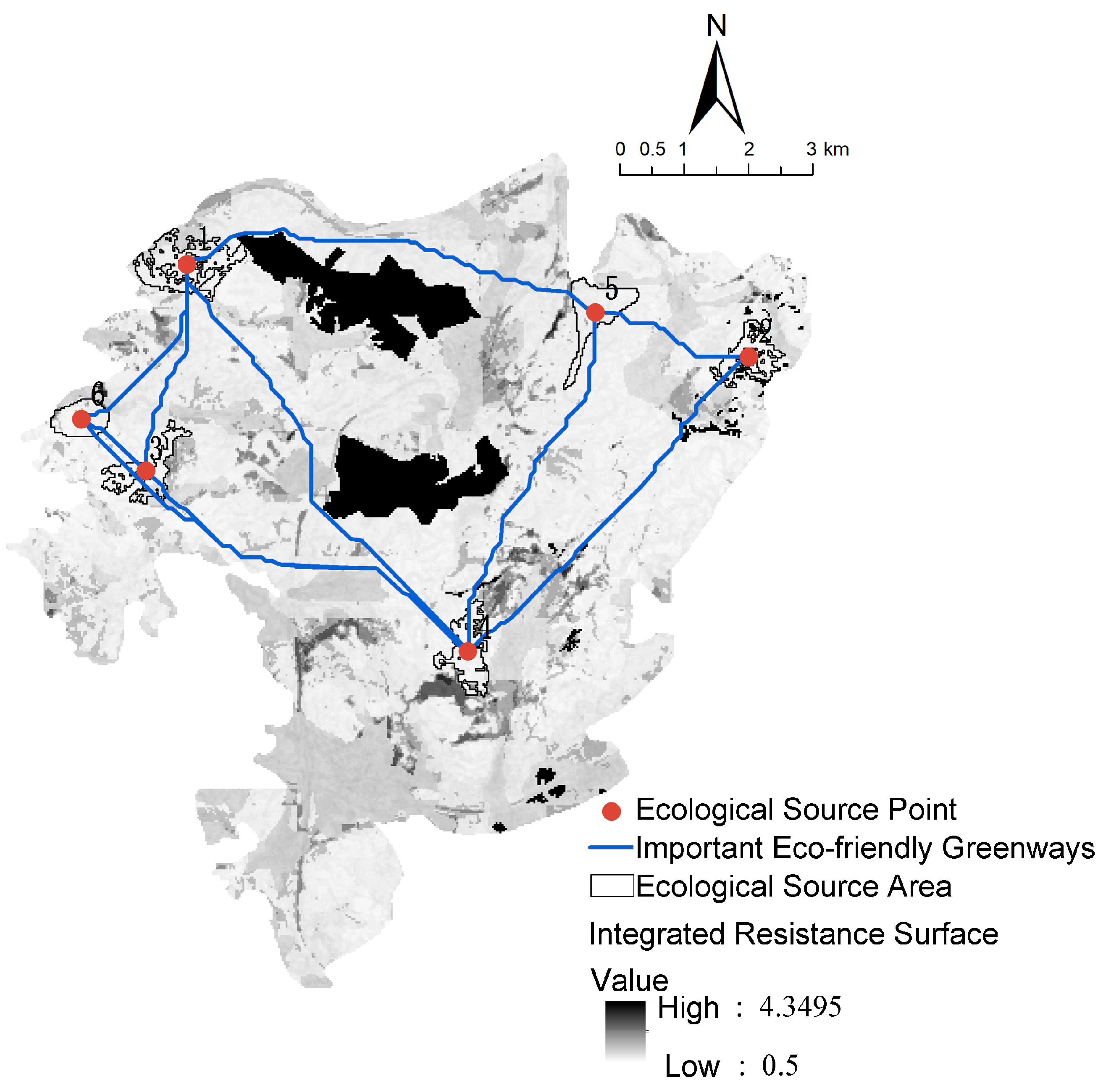
4.1. Simulation of Ecological Greenways
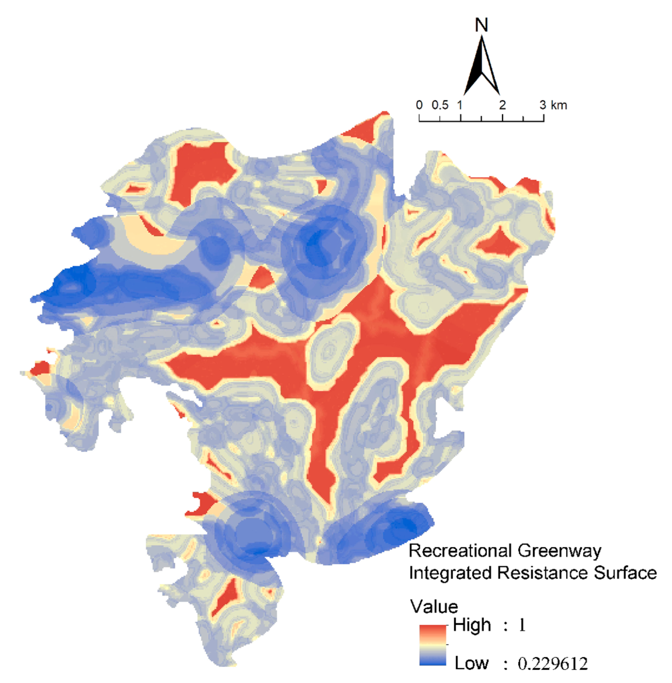
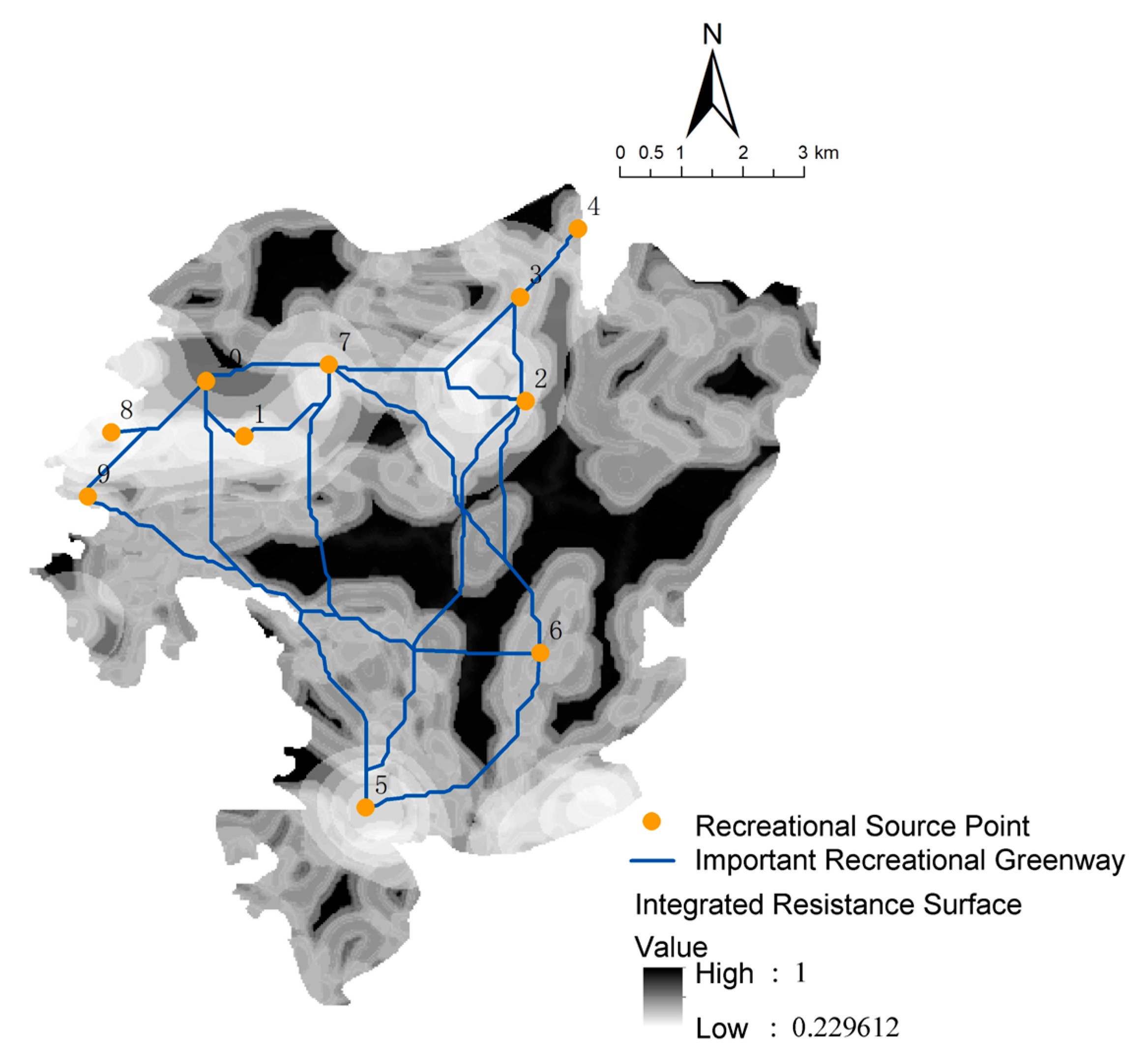
4.2. Simulation Results of Recreational Greenways
4.3. Simulation of “Ecology–Recreation” Greenway Network Routes
5. Optimization and Evaluation of the Jinma Mountain Greenway Network Post-Construction
5.1. Optimization of the Greenway Network
5.2. Hierarchical Optimization of the Greenway Network
5.3. Evaluation of the Greenway Network Structure
5.4. Feasibility Evaluation of the Greenway Network
5.5. Functional Evaluation of the Greenway Network
5.6. Planning Scheme for the Jinma Mountain Greenway Network
6. Discussion and Conclusions
6.1. Discussion
6.1.1. Methodological Contributions
6.1.2. Comparative Positioning with International Studies
6.1.3. Limitations
6.2. Conclusions
Author Contributions
Funding
Data Availability Statement
Acknowledgments
Conflicts of Interest
References
- Jongman, R.H.G.; Külvik, M.; Kristiansen, I. European ecological networks and greenways. Landsc. Urban Plan. 2004, 68, 305–319. [Google Scholar] [CrossRef]
- Fabos, J.G. Greenway planning in the United States: Its origins and recent case studies. Landsc. Urban Plan. 2004, 68, 321–342. [Google Scholar] [CrossRef]
- Horte, O.S.; Eisenman, T.S. Urban Greenways: A Systematic Review and Typology. Land 2020, 9, 40. [Google Scholar] [CrossRef]
- Carlier, J.; Moran, J. Hedgerow typology and condition analysis to inform greenway design in rural landscapes. J. Environ. Manag. 2019, 247, 790–803. [Google Scholar] [CrossRef] [PubMed]
- Anderson, C.E.; Zimmerman, A.; Lewis, S.; Marmion, J.; Gustat, J. Patterns of Cyclist and Pedestrian Street Crossing Behavior and Safety on an Urban Greenway. Int. J. Environ. Res. Public Health 2019, 16, 201. [Google Scholar] [CrossRef]
- Lopes, I.J.; Biondi, D.; Corte, A.P.; Reis, A.R.; Oliveira, T.G. A methodological framework to create an urban greenway network promoting avian connectivity: A case study of Curitiba City. Urban For. Urban Green. 2023, 87, 128050. [Google Scholar] [CrossRef]
- Balbi, M.; Croci, S.; Petit, E.J.; Butet, A.; Georges, R.; Madec, L.; Caudal, J.P.; Ernoult, A. Least-cost path analysis for urban greenways planning: A test with moths and birds across two habitats and two cities. J. Appl. Ecol. 2021, 58, 632–643. [Google Scholar] [CrossRef]
- Wang, R.; Browning, M.H.; Kee, F.; Hunter, R.F. Exploring mechanistic pathways linking urban green and blue space to mental wellbeing before and after urban regeneration of a greenway: Evidence from the Connswater Community Greenway, Belfast, UK. Landsc. Urban Plan. 2023, 235, 104739. [Google Scholar] [CrossRef]
- Harris, B.; Larson, L.; Ogletree, S. Different Views from the 606: Examining the Impacts of an Urban Greenway on Crime in Chicago. Environ. Behav. 2018, 50, 56–85. [Google Scholar] [CrossRef]
- Noh, Y. Does converting abandoned railways to greenways impact neighboring housing prices? Landsc. Urban Plan. 2019, 183, 157–166. [Google Scholar] [CrossRef]
- Yu, K.; Li, D.; Li, N. The Evolution of Greenways in China. Landsc. Urban Plan. 2006, 76, 223–239. [Google Scholar] [CrossRef]
- Liu, Z.; Lin, Y.; De Meulder, B.; Wang, S. Can greenways perform as a new planning strategy in the Pearl River Delta, China? Landsc. Urban Plan. 2019, 187, 81–95. [Google Scholar] [CrossRef]
- Lin, J.; Wang, Y.; Lin, Z.; Li, S. National-scale connectivity analysis and construction of forest networks based on graph theory: A case study of China. Ecol. Eng. 2025, 216, 107639. [Google Scholar] [CrossRef]
- Xiong, S.; Yang, F.; Zhang, J.; Tang, Y. An integrated model chain for diagnosing and predicting conflicts between production-living-ecological space in lake network regions: A case of the Dongting Lake region, China. Ecol. Indic. 2024, 166, 112237. [Google Scholar] [CrossRef]
- Li, L.; Gao, X.; Li, J.; Meng, L.; Wang, Z.; Yang, L. Difference of Usage Behavior between Urban Greenway and Suburban Greenway: A Case Study in Beijing, China. Land 2022, 11, 1245. [Google Scholar] [CrossRef]
- Xu, B.; Shi, Q.; Zhang, Y. Evaluation of the Health Promotion Capabilities of Greenway Trails: A Case Study in Hangzhou, China. Land 2022, 11, 547. [Google Scholar] [CrossRef]
- Callau, A.À.; Pérez-Albert, Y.; Farías-Torbidoni, E.I.; Mas-Alòs, S.; González, J.A.; Peris, M.G. Enhancing outdoor recreational experience: A methodology for assessing peri-urban greenway suitability based on hiker physical activity levels and motivations. J. Outdoor Recreat. Tour. 2025, 50, 100893. [Google Scholar] [CrossRef]
- Keith, S.J.; Larson, L.R.; Shafer, C.S.; Hallo, J.C.; Fernandez, M. Greenway use and preferences in diverse urban communities: Implications for trail design and management. Landsc. Urban Plan. 2018, 172, 47–59. [Google Scholar] [CrossRef]
- Liu, X.R.; Yin, H.W.; Xu, J.G.; Kong, F.H.; Hou, Y.J. Developing Multi-functional and Composite Urban Greenway Network in Luoyang Based on LCP. Mod. Urban Res. 2018, 1, 126–131. [Google Scholar]
- Tang, Z.Y.; Ye, Y.; Jiang, Z.D.; Fu, C.W.; Huang, R.; Yao, D. A data-informed analytical approach to human-scale greenway planning: Integrating multi-sourced urban data with machine learning algorithms. Urban For. Urban Green 2020, 56, 126871. [Google Scholar] [CrossRef]
- Yuan, S.; Dai, W.; Zhang, Y.; Yang, J. Cycling Greenway Planning towards Sustainable Leisure and Recreation: Assessing Network Potential in the Built Environment of Chengdu. Sustainability 2024, 16, 6185. [Google Scholar] [CrossRef]
- Bai, Y.; Bai, Y.; Wang, R.; Yang, T.; Song, X.; Bai, B. Exploring associations between the built environment and cycling behaviour around urban greenways from a human-scale perspective. Land 2023, 12, 619. [Google Scholar] [CrossRef]
- Jiang, J.L.; Gao, Z.; Xu, Y.Y.; Chen, J. Research on Planning of Intelligent Route Selection for Greenway in Central Urban Area: A Case Study of Suqian. Landsc. Archit. 2023, 30, 103–110. [Google Scholar]
- Cheng, X.; Long, R.; Chen, H.; Li, Q. Coupling coordination degree and spatial dynamic evolution of a regional green competitiveness system—A case study from China. Ecol. Indic. 2019, 104, 489–500. [Google Scholar] [CrossRef]
- Mu, W.; Li, C. Optimization of urban greenway route using a coverage maximization model for lines. Comput. Environ. Urban Syst. 2024, 112, 102155. [Google Scholar] [CrossRef]
- Kurdoğlu, B.Ç.; Kurt, S.S. Determination of greenway routes using network analysis in Amasya, Turkey. J. Urban Plan. Dev. 2017, 143, 05016013. [Google Scholar] [CrossRef]
- Luo, D.; Liang, L.; Wang, Z.; Chen, L.; Zhang, F. Exploration of coupling effects in the Economy–Society–Environment system in urban areas: Case study of the Yangtze River Delta Urban Agglomeration. Ecol. Indic. 2021, 128, 107858. [Google Scholar]
- Yu, L.; Wang, Y.; Li, M. The emergence of counter-urbanisation in China: Can it be a pathway for rural revitalisation? Habitat Int. 2024, 144, 102998. [Google Scholar] [CrossRef]
- Tang, H.; Hong, Q.; Xu, B. Landscape performance assessment of phase I of greenway around Qingshan Lake National Forest Park, Zhejiang Province. J. Zhejiang AF Univ. 2020, 37, 1177–1185. [Google Scholar]
- Trojanowska, M. The Importance of Resilient, Health-Promoting, and Accessible Cultural Landscapes Using the Example of One Suburb of Gdańsk, Poland. Sustainability 2024, 16, 3652. [Google Scholar] [CrossRef]
- Ying, B.; Ke, L.; Zhu, F.; He, N. Towards differentiated development policies for mountainous areas: A spatial analysis of mountain distribution and characteristics in a geographic region. Land Degrad. Dev. 2023, 34, 5071–5082. [Google Scholar] [CrossRef]
- Li, F.; Wang, R.; Paulussen, J.; Liu, X. Comprehensive concept planning of urban greening based on ecological principles: A case study in Beijing, China. Landsc. Urban Plan. 2005, 72, 325–336. [Google Scholar] [CrossRef]
- Conine, A.; Xiang, W.N.; Young, J.; Whitley, D. Planning for multi-purpose greenways in Concord, North Carolina. Landsc. Urban Plan. 2004, 68, 271–287. [Google Scholar] [CrossRef]
- Zhao, N.; Liu, Z.; Lin, Y.; De Meulder, B. User, public, and professional perceptions of the greenways in the Pearl River Delta, China. Sustainability 2019, 11, 7211. [Google Scholar] [CrossRef]
- Vizzari, M. Spatial modelling of potential landscape quality. Appl. Geogr. 2011, 31, 108–118. [Google Scholar] [CrossRef]
- Liu, S.L.; Hou, X.Y.; Yin, Y.J.; Cheng, F.Y.; Zhang, Y.Q.; Dong, S. Research progress on landscape ecological networks. Acta Ecol. Sin. 2017, 37, 3947–3956. [Google Scholar] [CrossRef][Green Version]
- Su, X.; Wu, J.; Li, P.; Li, R.; Cheng, P. RSEI-Based Modeling of Ecological Security and Its Spatial Impacts on Soil Quality: A Case Study of Dayu, China. Sustainability 2022, 14, 4428. [Google Scholar] [CrossRef]
- Luo, Q.; Bao, Y.; Wang, Z.; Chen, X.; Wei, W.; Fang, Z. Vulnerability assessment of urban remnant mountain ecosystems based on ecological sensitivity and ecosystem services. Ecol. Indic. 2023, 151, 110314. [Google Scholar] [CrossRef]
- Zhao, Y.; Kasimu, A.; Liang, H.; Reheman, R. Construction and Restoration of Landscape Ecological Network in Urumqi City Based on Landscape Ecological Risk Assessment. Sustainability 2022, 14, 8154. [Google Scholar] [CrossRef]
- Floress, K.; Baumgart-Getz, A.; Prokopy, L.S.; Janota, J. The quality of greenways planning in northwest Indiana: A focus on sustainability principles. J. Environ. Plan. Manag. 2009, 52, 61–78. [Google Scholar] [CrossRef]
- SL 773-2018; Guidelines for Measurement and Estimation of Soil Erosion in Production and Construction Projects. China Water & Power Press: Beijing, China, 2018.
- Mou, N.; Zheng, Y.; Makkonen, T.; Yang, T.; Tang, J.J.; Song, Y. Tourists’ digital footprint: The spatial patterns of tourist flows in Qingdao, China. Tour. Manag. 2020, 81, 104151. [Google Scholar] [CrossRef]
- Ministry of Housing and Urban-Rural Development of the People’s Republic of China. Guidelines for Greenway Planning and Design. Available online: https://www.mohurd.gov.cn/gongkai/zc/wjk/art/2016/art_17339_229168.html (accessed on 14 October 2016).
- Zhang, Y.; Li, M.; Chen, D. Grain effect and appropriate grain choosing of land-use spatial pattern. In Proceedings of the Geoinformatics 2007: Geospatial Information Science, Nanjing, China, 25–27 May 2007; Volume 6753, pp. 216–226. [Google Scholar]
- Cui, D.; Chen, X.; Xue, Y.; Li, R.; Zeng, W. An integrated approach to investigate the relationship of coupling coordination between social economy and water environment on urban scale—A case study of Kunming. J. Environ. Manag. 2019, 234, 189–199. [Google Scholar] [CrossRef]
- Ministry of Environmental Protection of the People’s Republic of China. Technical Specification for Evaluation of Ecological Environment Status (HJ 192-2015); China Science Press: Beijing, China, 2015. [Google Scholar]
- Peng, J.; Zhao, S.; Dong, J.; Liu, Y.; Meersmans, J.; Li, H.; Wu, J. Applying ant colony algorithm to identify ecological security patterns in megacities. Environ. Model. Softw. 2019, 117, 214–222. [Google Scholar] [CrossRef]
- Pingjiang, Z.; Guofeng, D. Construction of ecological security pattern of Tao River Basin based on MCR model and ant colony algorithm. Ecol. Environ. 2023, 32, 481. [Google Scholar]
- Qiu, X.; He, W.; Zheng, S. Research on ecological network identification in rare animal habitats based on the MaxEnt model and ant colony algorithm: A case study of Giant Panda National Park, China. Biodivers. Conserv. 2024, 33, 3207–3229. [Google Scholar] [CrossRef]
- Tan, K.W. A greenway network for Singapore. Landsc. Urban Plan. 2006, 76, 45–66. [Google Scholar] [CrossRef]
- Zhang, Z.; Meerow, S.; Newell, J.P.; Lindquist, M. Enhancing landscape connectivity through multifunctional green infrastructure corridor modeling and design. Urban For. Urban Green. 2019, 38, 305–317. [Google Scholar] [CrossRef]
- Liu, Y.F.; Liang, J.Y.; Huang, Z.W.; Nan, J.N. Study on the Translations and Changes of the Image of Mountains and Waters in Zhuge Village in Zhejiang Province. Chin. Landsc. Archit. 2020, 36, 63–67. [Google Scholar]
- Zhou, G.; Huan, Y.; Wang, L.; Lan, Y.; Liang, T.; Shi, B.; Zhang, Q. Linking ecosystem services and circuit theory to identify priority conservation and restoration areas from an ecological network perspective. Sci. Total Environ. 2023, 873, 162261. [Google Scholar] [CrossRef]
- Li, J.; Sun, W.; Li, M.; Meng, L. Coupling coordination degree of production, living and ecological spaces and its influencing factors in the Yellow River Basin. J. Clean. Prod. 2021, 298, 126803. [Google Scholar] [CrossRef]
- Jieling, L.; Ling, Z.; Hui, F. Construction of wetland ecological network based on MSPA-Conefor-MCR: A case study of Haikou City. Ecol. Indic. 2024, 166, 112329. [Google Scholar]
- Lu, J.; Wu, X. Research on Urban Greenway Alignment Selection Based on Multisource Data. Sustainability 2022, 14, 12382. [Google Scholar] [CrossRef]
- Teng, M.; Wu, C.; Zhou, Z.; Lord, E.; Zheng, Z. Multipurpose greenway planning for changing cities: A framework integrating priorities and a least-cost path model. Landsc. Urban Plan. 2011, 103, 1–14. [Google Scholar] [CrossRef]
- Wang, Z.; Huang, W.-J.; Liu-Lastres, B. Impact of user-generated travel posts on travel decisions: A comparative study on Weibo and Xiaohongshu. Ann. Tour. Res. Empir. Insights 2022, 3, 2. [Google Scholar] [CrossRef]
- Brown, G.; Kyttä, M. Key issues and research priorities for public participation GIS (PPGIS): A synthesis based on empirical research. Appl. Geogr. 2014, 46, 122–136. [Google Scholar] [CrossRef]
- Jang, M.; Kang, C.-D. Urban greenway and compact land use development: A multilevel assessment in Seoul, South Korea. Landsc. Urban Plan. 2015, 143, 160–172. [Google Scholar] [CrossRef]
- Hoctor, T.S.; Bohnett, E.; O’Brien, M.; Thompson, E.; Noss, R.; Lockhart, S.; Volk, M.; Carr, P.; Smith, D.J.; Guthrie, J.M.; et al. Refining the Florida ecological greenways network for improved landscape planning and conservation prioritization. Landsc. Ecol 2025, 40, 36. [Google Scholar] [CrossRef]
- Effrey, L. Marion, Trail sustainability: A state-of-knowledge review of trail impacts, influential factors, sustainability ratings, and planning and management guidance. J. Environ. Manag. 2023, 340, 117868. [Google Scholar]
- Beltrão, M.G.; Gonçalves, C.F.; Brancalion, P.H.; Carmignotto, A.P.; Silveira, L.F.; Galetti Jr, P.M.; Galetti, M. Priority areas and implementation of ecological corridor through forest restoration to safeguard biodiversity. Sci. Rep. 2024, 14, 30837. [Google Scholar] [CrossRef] [PubMed]




| Criteria Layer (Weights) | Index Layer | Indicator Calculation |
|---|---|---|
| Single factor (0.5) | Land use | Resistance values for various land-use types, as determined by previous studies. |
| Distance from the main roads in the city | Obtain the official urban road vector data and calculate the Euclidean distance from the road to the entire space. | |
| Soil and water loss | The Universal Soil Loss Equation (USLE) was used to evaluate the amount of soil erosion, where the rainfall erosion force was calculated according to the Guidelines for Calculation of Soil Loss in Production and Construction Projects (SL773-2018 [41]). | |
| Slope | The Digital Elevation Model (DEM) data are processed using Geographic Information System (GIS) technology to obtain the slope data of the study area, which is then classified according to the road construction standard. | |
| Elevation | DEM data were classified into five height classes using equal interval average classification in GIS. | |
| Fractional Vegetation Cover | After calculating Fractional Vegetation Cover (FVC) values with Environment for Visualizing Images (ENVI), the ranks were divided using the equal interval mean classification in GIS. | |
| Composite factor (0.5) | Ecological Protection Red Lines and Permanent Basic Farmland Protection Red Lines | Since relevant studies rarely involve the protection of red line buffer zones, the “within two lines” and “outside two lines” are assigned. |
| Criteria Layer (Weights) | Indicator Layer | Score Value |
|---|---|---|
| Resource level (0.45) | National protection, famous historical towns and villages, and traditional villages. | 5 |
| Provincial protection, temples, and characteristic cultural villages. | 3 | |
| City protection, historical and cultural relics, and general villages. | 1 | |
| Degree of protection (0.19) | Complete body shape, comprehensive information, or cultural protection is particularly good. | 5 |
| Complete integrity, with a lack of data or good cultural protection. | 3 | |
| Incomplete body, with a lack of data or general cultural protection. | 1 | |
| Cultural value (0.29) | Built a long time ago or there are distinctive folk customs. | 5 |
| Built a long time ago and the characteristic folk customs are widely spread. | 3 | |
| The construction age is not too long or there is a lack of characteristic folk customs. | 1 | |
| Accessibility (0.07) | Proximity to arterial roads, scenic roads, or village roads with good accessibility. | 5 |
| Proximity to the village branch road or the village road accessibility is general. | 3 | |
| Poor transportation. | 1 |
| Criterion Layer (Weight) | Index Layer | Indicator Calculation |
|---|---|---|
| Construction suitability (0.5) | Slope | The suitability is divided according to the “Guidelines for Greenway Planning and Design” and previous studies. |
| Distance from the road | Obtain the existing road data for the hiking path, hiking path, and forest fire path, and calculate the Euclidean distance from the road to the entire space. | |
| Distribution of service facilities | Nuclear density analysis and natural breakpoint methods are used to divide the construction feasibility class of service facilities. | |
| Distance from the residential | According to the walking circle radius of 5 min, 10 min, and 5 min, the buffer distances are defined as 300 m, 500 m, 1000 m, and 1500 m, respectively. | |
| Landscape visual suitability (0.5) | Patch Richness Density(PRD) | The richness density is calculated using the moving window function in Fragstats 4.2. |
| Shannon’s Diversity Index (SHDI) | Shannon’s Diversity Index is calculated by using the moving window function in Fragstats. | |
| Simpson’s Evenness Index (SIEI) | The Simpson uniformity index is calculated using the moving window function in Fragstats. | |
| Contagion Index (CONT) | The Contagion Index is calculated using the moving window function in Fragstats. |
| Resistance Factor | Weight | Resistance Level Division and Value Assignment | ||||
|---|---|---|---|---|---|---|
| 1 | 2 | 3 | 4 | 5 | ||
| Land use | 0.105 | forestry | meadow | water area | cultivated land | Urban and rural areas, industrial and residential |
| Distance from the main road | 0.024 | ≥1500 | 900~1500 | 600~900 | 300~600 | <300 |
| Soil and water loss | 0.707 | <0.98 | 0.98~3.65 | 3.65~8.55 | 8.55~16.69 | 16.69~35.76 |
| Slope | 0.057 | 0~2° | 2°~10° | 10°~20° | 20°~25° | ≥25° |
| Elevation | 0.032 | 1753~1864 | 1864~1976 | 1976~2087 | 2087~2199 | 2199~2311 |
| Vegetation coverage | 0.075 | ≥0.8 | 0.6~0.8 | 0.4~0.6 | 0.2~0.4 | <0.2 |
| Index | Resistance Factor | Weight | Suitable Grade | ||||
|---|---|---|---|---|---|---|---|
| 1 | 2 | 3 | 4 | 5 | |||
| Construction suitability evaluation | Falling gradient/% | 0.011 | >8% | 5%~8% | 3%~5% | 2.5%~3% | <2.5% |
| Distance from the road | 0.025 | ≥160 | 120~160 | 80~120 | 40~80 | <40 | |
| Distribution of service facilities | 0.933 | <1.52 | 1.52~5.05 | 5.05~9.62 | 9.62~14.76 | >14.76 | |
| Distance from the residential point | 0.031 | >1500 | 1000~1500 | 500~1000 | 300~500 | <300 | |
| Evaluation of landscape visual suitability | CONTAG | 0.197 | <0.1 | 0.1~0.4 | 0.4~0.7 | 0.7~0.9 | ≥0.9 |
| PRD | 0.247 | <0.2 | 0.2~0.4 | 0.4~0.6 | 0.6~0.8 | ≥0.8 | |
| SHDI | 0.278 | <0.2 | 0.2~0.3 | 0.3~0.4, ≥0.9 | 0.4~0.6, 0.7~0.9 | 0.6~0.7 | |
| SIEI | 0.278 | <0.2 | 0.2~0.4 | 0.4~0.7 | 0.6~0.8 | ≥0.8 | |
| Greenway Type | α Index | β Index | γ Index |
|---|---|---|---|
| Ecotype sub-greenway | 0.57 | 3.00 | 0.75 |
| Recreational sub-greenway | 0.53 | 3.00 | 0.71 |
| Composite greenway network | 0.62 | 3.06 | 0.76 |
| Criterion Layer (Weight) | Index Layer | Indicator Acquisition | Weight |
|---|---|---|---|
| Ecology function (0.5) | Ecological environment quality | RSEI | 0.545 |
| Soil and water loss | USLE | 0.296 | |
| Climate regulation | Ecosystem service | 0.091 | |
| Biodiversity | Function value equivalent | 0.068 | |
| Recreation function (0.5) | Landscape visual quality | Landscape visual evaluation | 0.490 |
| Convenience of service | Nuclear density of service facilities | 0.309 | |
| Recreation facilities accessibility | Distance from the residential point | 0.137 | |
| Number of cultural recreation resources | Number of cultural recreation points | 0.064 |
Disclaimer/Publisher’s Note: The statements, opinions and data contained in all publications are solely those of the individual author(s) and contributor(s) and not of MDPI and/or the editor(s). MDPI and/or the editor(s) disclaim responsibility for any injury to people or property resulting from any ideas, methods, instructions or products referred to in the content. |
© 2025 by the authors. Licensee MDPI, Basel, Switzerland. This article is an open access article distributed under the terms and conditions of the Creative Commons Attribution (CC BY) license (https://creativecommons.org/licenses/by/4.0/).
Share and Cite
Wei, W.; Yang, A.; Jiang, L.; Lawson, G.; Lei, W. Ecological Recreation Across the Jinma Mountain Region: A Comprehensive Evaluation of Suburban Mountain Greenway Networks. Land 2025, 14, 1532. https://doi.org/10.3390/land14081532
Wei W, Yang A, Jiang L, Lawson G, Lei W. Ecological Recreation Across the Jinma Mountain Region: A Comprehensive Evaluation of Suburban Mountain Greenway Networks. Land. 2025; 14(8):1532. https://doi.org/10.3390/land14081532
Chicago/Turabian StyleWei, Wen, Ao Yang, Lanxi Jiang, Gillian Lawson, and Wen Lei. 2025. "Ecological Recreation Across the Jinma Mountain Region: A Comprehensive Evaluation of Suburban Mountain Greenway Networks" Land 14, no. 8: 1532. https://doi.org/10.3390/land14081532
APA StyleWei, W., Yang, A., Jiang, L., Lawson, G., & Lei, W. (2025). Ecological Recreation Across the Jinma Mountain Region: A Comprehensive Evaluation of Suburban Mountain Greenway Networks. Land, 14(8), 1532. https://doi.org/10.3390/land14081532


