Article

Diagnosis of the Situation of the Land Administration System in Ibero-America

by
Carmen Femenia-Ribera
1,*,
Gaspar Mora-Navarro
1,
Inmaculada Marques-Perez
2,
Enric Terol
1 and
Cristhian Quiza-Neuto
3
1
Department of Cartographic Engineering, Geodesy and Photogrammetry, Universitat Politècnica de València, 46022 Valencia, Spain
2
Department of Economy and Social Sciences, Universitat Politècnica de València, 46022 Valencia, Spain
3
Geomatics and Geoinformation Engineering, Universitat Politècnica de València, 46022 Valencia, Spain
*
Author to whom correspondence should be addressed.
Land 2025, 14(7), 1376; https://doi.org/10.3390/land14071376
Submission received: 15 May 2025 / Revised: 25 June 2025 / Accepted: 26 June 2025 / Published: 30 June 2025

Abstract

In this research, we have compiled and analysed the organisations and studies that jointly address the issue of land administration, fundamentally in the cartographic aspects related to the cadastre and land registry, in the international environment, and at the Ibero-American level. Through qualitative social research, interviews were conducted with internationally recognised experts on issues of general cartography, cartography and legal security, and related to cadastral valuation, obtaining conclusions that allow a general diagnosis of the situation of the Land Administration System in Ibero-America. In this environment, problems such as the heterogeneity of systems, overlapping of competencies, instability, lack of sustainability, need for standards, lack of transparency, etc., should be highlighted, among others. Finally, based on the compilation of existing data from the Cadastre Data survey conducted in 2011 by the Permanent Committee of Cadastre in Ibero-America, and with information from its members and member organisations of the Pan-American Association of Professional Surveyors, the geoportal Diagnosis of the Situation of the Land Administration System in Ibero-America has been created. This geoportal allows the initial identification of the different organisations and general regional data.

1. Introduction

According to [1], “land administration system is a set of institutional arrangements, legal frameworks, and technical infrastructure that support the management of land rights and restrictions”. Or as defined in the Economic Commission for Europe [2], “A land administration system is a system for the management of land and land tenure. It includes the legal, institutional and technical framework for the registration of land rights, the valuation of land, and the management of land use and development.”
This research has analysed the land administration systems (LASs) of the Ibero-American region, focusing this study on cadastre bodies (graphic register of real estate) from two points of view related to the legal security of land tenure through the relationship with the land registers (register of rights), and related to cadastral valuation, and all of this from the point of view of cartography, making a general diagnosis of the current situation.
It should be noted that work is currently underway on a glossary specific to the Ibero-American environment as an initiative of the Permanent Committee on Cadastre in Ibero-America (Comité Permanente del Catastro en Iberoamérica, CPCI) since the words used may have different meanings depending on the region. In Spanish, the word ‘catastro’ has a different meaning than the word ‘cadastre’ in English. In countries with a Latin American model similar to Spain’s, with separate bodies to manage cadastre and land registry, as in most Latin American countries, the word ‘cadastre’ is mainly associated with valuation. This study considers a broader context, which includes the legal certainty provided by the land registry, which is why the term’ land administration’ is used in this research.
First of all, and framing the geographical context, it should be explained that, of all the countries that make up the American continent, there is a group of countries usually identified as Latin American that share a cultural and linguistic heritage derived from Iberian colonisation, both Spanish and Portuguese. Ibero-America includes Spanish-speaking countries (such as Mexico, Argentina, Colombia, etc.) and Brazil, where Portuguese is spoken. This region is united by historical, cultural, social, and political ties that have influenced its development, playing an important role in the international arena [3,4,5,6].
Ibero-America is a region that covers approximately 21 million square kilometres, divided between countries [7] of the continents of America and Europe, and is home to more than 724 million inhabitants [8]. With the exception of European countries (such as Spain and Portugal), it faces significant challenges in managing its territory due to rapid urbanisation, unequal access to services, and vulnerability to natural disasters [9]. It is estimated that 81% of the population of Latin America and the Caribbean lives in cities, which has generated a disorderly urban sprawl and an increase in informal settlements that affect the sustainability of urban development [9]. Moreover, the growth of cities has not always been accompanied by efficient spatial planning, resulting in institutional fragmentation and unequal land governance [10]. To address these challenges, countries in the region have adopted approaches such as de-centralisation and territorialisation of public investment. However, they have difficulties implementing effectively due to the lack of inter-institutional coordination and detailed geospatial information for decision-making [11].
A reasonably common characteristic in this region is that the LASs are based fundamentally on two pillars: the cadastre, as a graphic register of land, and the land registry, as a register of rights over this land. The cadastre generally has a fiscal purpose: to calculate the cadastral value to collect the property tax; the land registry has a legal security purpose, to protect land rights. These are two institutions, in most cases separate, which, in many countries, are based on models copied from Spain [12,13]. This separation does not exist in many European countries.
We can find some examples of studies where LASs are addressed jointly, or where a comparison is made between countries. At the international level, the Cadastral Template project should be highlighted [14,15,16], which was initiated in 2003 within the FIG; it is currently being revised through Working Group 7.8 about Comparative Land Administration [17]. Of particular importance is the Land Administration Domain Model (LADM), which was converted into an ISO standard in 2012 [18]. In Europe, since the 1990s, there have been several comparative studies of cadastral organisation models [19] or applying statistical techniques [20]; and, more recently, in 2023, within the Permanent Committee on Cadastre in the European Union (PCC-Europe), a questionnaire was carried out on the Contribution of the Cadastre to the Welfare State and the Role of Cadastre in Real Estate Valuation and Taxations [21]. Specifically in the Ibero-American context, it is worth highlighting the study Data Catastro of the CPCI [22]. The latest version was in 2011, and more recently, in 2022, a study by the Food and Agriculture Organization of the United Nations (FAO) was conducted on the state of the art of cadastres and land registries in Latin America and the Caribbean [23].
We can find comparative cadastral studies between specific countries [20]: Peru and Honduras [24]; Germany and Brazil [25]; China and Poland [26]; Slovakia and Poland [27]; Spain and Peru [28]; and Spain and Colombia [29].
The objective of this research is to initiate the path that will allow us to identify the challenges related to land tenure in a general context, which will help to support and provide greater efficiency to those projects that affect territorial development in Ibero-America, starting from the cartographic information of the territory, fundamental to cadastral and registry information. The aim is to identify needs and propose advances in cartographic aspects to strengthen the different territorial administration systems based on a diagnosis of the current situation. All of this, with the collaboration of international and Ibero-American groups that represent the vast majority of land administration systems in these countries.
This research compiles and analyses existing related bodies and studies that jointly address the issue of cadastre and registration, such as the Network of Ibero-American Cadastre Experts of the CPCI, the Inter-American Network of Cadastre and Property Registration of the Organisation of American States (Red Interamericana de Catastro y Registro de la Propiedad de la Organización de Estados Americanos RICRP-OAS), Commission 7 on Cadastre and Land Administration of the International Federation of Surveyors (FIG), the United Nations American Land Administration Network on Global Geospatial Information Management (UN-GGIM), the International Property Registries Association–International Centre for Registration Law (International Property Registries Association–Centro Internacional de Derecho Registral, IPRA-CINDER), the World Bank (WB), the Inter-American Development Bank (Banco Interamericano de Desarrollo (BID), the FAO Voluntary Guidelines on Responsible Governance of Land Tenure, the United Nations (UN) Framework for Effective Land Administration (FELA), and the LADM-ISO 19152 data model [30].
This study aims to initiate a path of cooperation and solidarity to confront challenges related to land tenure, and support and try to make the projects promoted by organisations and other international collaborators in the Ibero-American sphere more efficient.
A methodology is being designed that, based on the compilation of existing studies and needs, will make it possible to create a database that will be responsible for compiling the information necessary to carry out a detailed diagnosis of the land administration system in Ibero-America. This information will be represented in a geospatial database for the performance of analyses that support decision-making. Research techniques specific to the area are used, as well as social research techniques, both quantitative and qualitative (bibliographic studies, observation, interviews, and surveys).

2. Methodology

The research methodology is summarised in the following sections:
  • Compilation and analysis of information: Study of international organisations through their websites. Identify the presence of Ibero-American countries.
  • Qualitative social research through interviews with international experts: Questions on general cartography, cartography and legal security, and cartography and cadastral valuation.
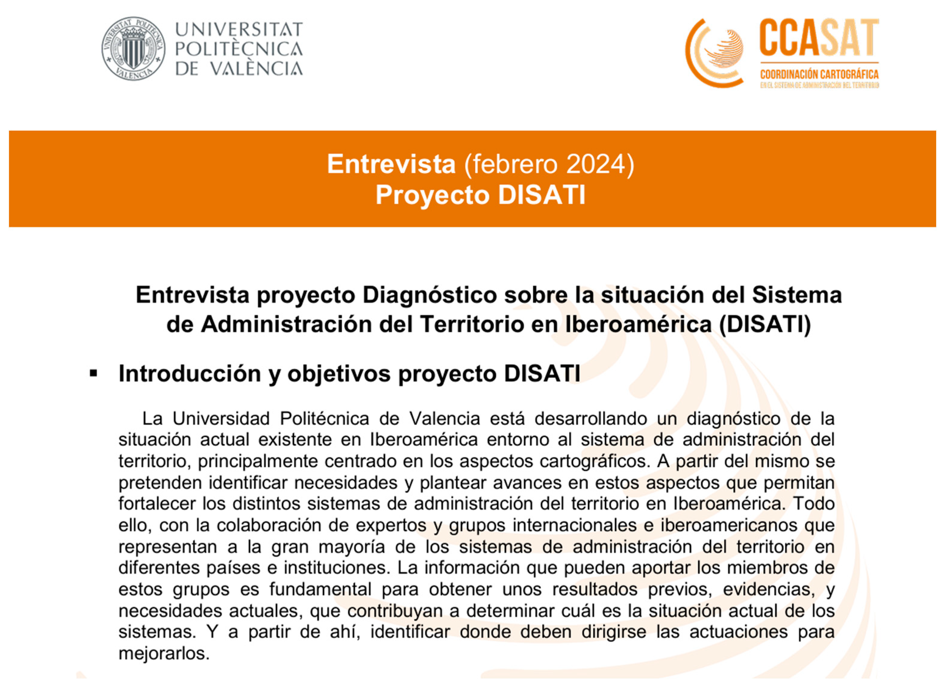
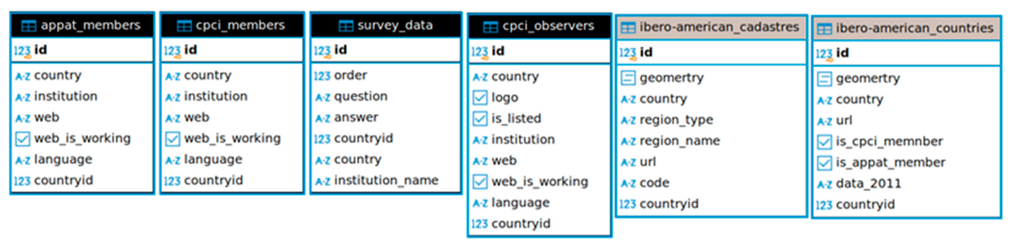
  • Diagnosis of the Situation of the Land Administration System in Ibero-America (Diagnóstico sobre la situación del Sistema de Administración del Territorio en Iberoamérica, DISATI) geoportal design: Recovery of alphanumeric data from Data Catastro, and members of CPCI and Pan-American Association of Professional Surveyors (Asociación Panamericana de Profesionales de la Agrimensura y Topografía, APPAT). Graphic data. Geoportal design.
  • Results and conclusions.
  • Future steps.

2.1. Information Gathering and Analysis

A compilation of existing information related to LASs in the international environment, and specifically in Latin America, was conducted for a first analysis. Organisations, associations, or different initiatives dealing with these issues were identified, and the existing information was studied through their websites.
From the information studied, a selection was made of those considered most relevant and closely related to the subject under study. It has been classified according to the geographical scope of the associated organisations. A distinction can be made between those formed strictly by Ibero-American countries and others of a more international nature. The following describes the institutions analysed in this research, listed in two categories according to their origin (international or specific to Ibero-America). They are listed in alphabetical order.
International Institutions:
  • Cadasta Foundation: A non-profit organisation that provides services and technologies for the documentation and management of tenure rights to land, property, and other natural resources. Its main objective is to empower marginalised and vulnerable populations who lack title to the land they occupy. It is active in more than 30 countries, 7 of them in Latin America [31].
  • Cadastral Templates 2.0: A set of standards for designing a format for organising, storing, and managing cadastral information. It has been developed under UN mandate by different partner agencies [16].
  • FAO-GLO (Global Land Observatory): It is an initiative of the FAO aimed at monitoring, collecting, and analysing data on land use and land tenure at the global level. It promotes sustainable, equitable, and responsible land management.
  • FAO-HIH (Hand in Hand): An FAO initiative that aims to improve some of the UN Sustainable Development Goals, particularly those related to accelerating agricultural transformation and sustainable rural development. Eleven Ibero-American countries are involved [32].
  • FIG (International Federation of Surveyors): An association of national bodies representing the interests of surveying engineers worldwide, covering the full range of fields related to geoinformation and geomatics. From Ibero-America, it includes Argentina, Portugal, Spain, Uruguay, Brazil, Colombia, Bolivia, Chile, and Mexico [33]. The FIG WG 7.8 is the FIG Commission 7 (Cadastre and Land Management), Working Group 8 (Comparative Land Administration) for 2023–2026 period. It is responsible for creating and disseminating data, making comparisons, and sharing strategies on land administration. It brings together several bodies, such as FAO, ONU-GGIM, the United Nations Programme on Human Settlements (UN-Habitat), or the United Nations Economic Commission for Europe [17].
  • GLTN (Global Land Tool Network) of UN-Habitat: It is a dynamic, multi-sectoral alliance of international partners committed to increasing access to land and security of tenure for all, with a special focus on the poor, women, and youth. It has a presence in Africa, Arab States, Asia Pacific, and Latin America and the Caribbean. It is currently implementing the Social Tenure Domain Model initiative in St. Lucia and St. Vincent and the Grenadines, both Caribbean islands [34,35].
  • ILC LATAM: The Latin American International Land Coalition’s network of platforms brings together over 250 members globally with the aim of establishing models of cooperation to promote the land-tenure rights of local communities. It involves 16 Ibero-American countries [36].
  • IPRA-CINDER: It is an independent organisation that brings together institutions in the field of property registration law. Since 1972, the International Property Registries Association has been promoting the exchange of knowledge in this field throughout the world. It brings together a multitude of countries, 19 of which are Latin American [37].
  • Land Portal: The non-profit organisation Land Portal Foundation was established in the Netherlands in 2014 to improve land-tenure rights and land administration worldwide. It involves partners such as the Netherlands Land Academy, the universities of Wageningen and Utrecht, the Royal Tropical Institute, and the Ministry of Foreign Affairs of the Netherlands [38].
  • OICRF (Office International du Cadastre et du Régime Foncier): It is a centre for cadastral research and documentation and land administration under the FIG. It offers a service to anyone requesting information through Kadaster (the Netherlands Agency for Cadastre, Land Registration, and Mapping) [39].
  • Prindex: This is an international non-profit initiative created to provide global insights into the security of land tenure. It is a partnership between the Global Land Alliance and the Overseas Development Institute. It takes the form of a survey and then a report, involving 20 Latin American countries [40,41].
  • SDGs Today: This is an initiative of the United Nations through its Sustainable Development Solutions Network, with the support of ESRI and the National Geographic Society. It aims to provide geospatial data for the improvement of the SDGs [42].
  • UN-Habitat: This is a United Nations programme with the aim of promoting socially and environmentally sustainable towns and cities. In the Ibero-American sphere, 7 countries participate [43].
Groupings of Ibero-American institutions specific to cadastre and property registration:
  • CPCI: This is an inter-governmental and international non-profit organisation within the framework of the Ibero-American countries. It was created in 2006 with the objective of promoting collaboration and the exchange of experiences for the development of cadastral systems [44].
  • IberoReg: This is an Ibero-American land registry network, created in October 2012. It is an interconnection project of the organisations responsible for public registries, which seeks to be a space for collaboration between institutions in which accurate and useful information is provided to citizens and administrations of all the countries of Ibero-America. At present, 19 Ibero-American countries are associated with it [45,46].
  • RICRP: The Inter-American Cadastre and Land Registry Network (Red Interamericana de Catastro y Registro de la Propiedad) [47] was created in 2014 with the objective of cooperating technically to promote best practices in cadastre and land registration in the Americas. It is supported by the Organisation of American States (Organización de los Estados Americanos, OEA), the WB, and the FAO.
Other Ibero-American groupings of interest in geospatial matters:
  • Americas SDI (Spatial Data Infrastructure): It is a geoportal that provides geospatial information and allows it to be visualised with a geoportal. It is the result of collaborative work under the auspices of the UN and its Economic Commission for Latin America and the Caribbean (Comisión Económica para América Latina y el Caribe, CEPAL), and with the participation of several geographic institutions [48].
  • APPAT: It is a non-profit organisation promoted by the Professional Associations of the discipline of surveying and topography, and the support of FIG. It comprises various bodies from a total of 16 Ibero-American countries [49].
  • Directorate General for Cadastre_Internacional: Highlight the international activity of the Spanish Directorate General of Cadastre [50], as it acts as an agent in the formation, maintenance, and dissemination of cadastral information through various forms of collaboration and intermediation between European countries (PCC-Europe, Geographic Information System of the European Commission, UN-GGIM, Working Party on Land Administration) and Ibero-Americans (CPCI, OEA/BM, RICRP).
  • Pan-American Institute of Geography and History (Instituto Panamericano de Geografía e Historia): It is a scientific–technical organisation that promotes interdisciplinary education and research. It depends on the OAS and involves a total of 18 Ibero-American countries [51].
Only information about public bodies or non-profit organisations is selected from the collected data. The websites are used to identify the Ibero-American countries present, the type of representation, and the language used. It can be seen that there is widespread participation by Ibero-American countries in Ibero-American groups or organisations, but they do not usually participate in international organisations.
Prior to this work, a specific study related to the pre-eminence of the university had already been carried out, looking at the situation of academia in land administration in Spain and Latin America [52,53]. It can be concluded that there is little Ibero-American representation, both academic and institutional, in the field of territorial administration in the international environment. Above all, in terms of active presence in the international arena.

2.2. Qualitative Social Research Through Interviews with International Experts

For some years now, qualitative research has established itself as a valid methodology for knowledge formation. Its methods are considered fundamental tools in different disciplines to enrich multi-, inter-, and trans-disciplinary research work. In these qualitative research methodologies, the subjectivity of people and the intersubjectivity within the contexts of study in which they are applied are prioritised. Thus, the beliefs, opinions, or judgements issued by people and social groups involved in the object of study are the basis of the analysis developed to generate new knowledge [54]. In this sense, the researchers, through dialogue, have to make an important effort to understand the information gathered, trying to grasp the meaning of each participant’s contributions to the object of the research, as well as to interpret and synthesise it, and to construct generalisations that allow them to understand the aspects common to the participants in relation to the object of the study [54,55].
This study applies qualitative social research methods to assess the current state of the LASs (land administration systems) in Ibero-American countries, identify necessities, and propose improvements, mainly related to cartography. For this purpose, semi-structured interview techniques were conducted to collect primary and secondary data about land administration in Ibero-American countries.
Interview techniques have been used in previous studies related to land administration systems: for data collection [56,57], assessing the use of different technologies [58,59], understanding needs and reviewing proposed models [60], and examining the effectiveness of territorial administration systems in post-conflict areas [61].
Interviewees were drawn from a broad base of expertise that was selected strategically. In this sense, various profiles of people were involved at the technical, academic, and administrative levels, including participants from international and Ibero-American institutions related to territorial administration systems in different countries [62]. This strategic selection was made based on the judgement sampling technique, which requires some prior knowledge of the experts [63]. So, experts were selected because they have been working in LASs for a long time, in some Ibero-American countries, with different land-tenure projects and entities, and sometimes in projects funded by international finance institutions. They are professionals actively involved in public policy and Land Governance, specialists in land development and special planning, academics actively engaged in land tenure and land development research, and technicians working in land-based investments from both public and private institutions. Table 1 shows the expert’s background:
Experts referred to in Table 2 have much experience in cadastre and have moved between different entities with different roles.
Expert interviews were designed using the open-ended questions technique. These are used alone or in combination with other interviewing techniques, inter alia, to explore topics in-depth and to understand processes [64]. In this sense, this technique was considered appropriate for collecting information on the current state of LASs in Ibero-American countries.
With each expert, an interview was conducted online, lasting more than an hour. The preparation started in January 2024, and the interviews took place from April to June. Interviews were conducted online using Microsoft Teams, a workspace for real-time collaboration and communication, meetings, and file and app sharing. Virtual interviews can be substituted for face-to-face in-person interviews. According to [65], the use of video technologies in qualitative research is possible by access to affordable high-speed internet, smartphones, personal computers, and free user-friendly video-based communication software for both interviewees and researchers. It can lead to substantial cost savings on travel and accommodation, particularly when interview participants are geographically dispersed, as is in this particular case. On the other hand, it allows the interviewer to use body language (facial expressions and hand movements) to develop greater rapport with interviewees, such as through face-to-face interviews. The interviews were conducted in most cases by two interviewers.
All interviews were conducted in Spanish to use the same terminology. In cases of possible confusion during the interview, the concept being asked about was clarified during the interview itself.
Each interview was recorded and transcribed with the consent of the interviewees. Six interviewees were female, and eight were male, for a total of fourteen interviews. For this research, it was not important to use representative statistics of experts because their value is derived from their knowledge, experience, and understanding of the research subject, making them considered opinion leaders within their category. On the other hand, the principle of saturation was used to limit and justify the number of expert participants, making additional interviews unnecessary [64].
Before the interview session, experts were contacted via email. Each interviewee received information about the research project DISATI, their objectives, and information about the interview: objectives, the profile of expertise, and the list of questions. The semi-structured interview form includes 10 questions grouped into three categories: (I) general questions about LASs in Ibero-American countries (strengths and weaknesses, necessities), (II) cartography and land-tenure security, and (III) cartography as the basis of taxation. The information provided to the interviewees can be seen in Figure 1.
To obtain the results, the interview questions are structured around the three categories. Different topics are addressed in each category, as shown in Figure 2.
The results of interviews conducted with stakeholders were analysed thoroughly by categories and topics following the previous scheme. A first reading of all the interview notes was carried out. From this first reading, the first findings were extracted, organised, and grouped according to the general outline. These were compared with the archived videos and transcripts. A subsequent review was carried out to validate and refine the findings and to extract the main ideas around the actual situation of the land administration systems in Ibero-America. The saturation point was reached for most of the topics, so the number of interviews conducted was considered sufficient. A detailed report (in Spanish) on social research is obtained, where the former experts interviewed give their opinions on the situation of the land administration system in Ibero-America and its relation to cartography. This report is available as a contribution from CPCI members at the annual meeting in 2024 [66].

2.3. DISATI Geoportal Design

In this research, a geoportal has been created to show the existing cadastral information in Ibero-America, as there is currently no similar complete representation. We call this geoportal DISATI. The closest thing to this joint representation, and in a more generic way, is the geospatial information at the Americas level that is in the Americas Spatial Data Infrastructure (IDE Américas) [48].
Regarding specific cadastre information, and in alphanumeric format, data can be found in “Data Catastro”, a survey designed to compile, compare, and analyse variables that can account for managing the cadastral and registry institutions of the CPCI members [67]. For the associated thematic information to be included in the DISATI geoportal, the latest available data from “Data Catastro” from 2011 have been used. This is a survey aimed at Ibero-American countries that seeks to highlight the importance of the cadastre, and of cadastral institutions, in decision-making oriented towards territorial development. This initiative took the form of a magazine, with three editions (May 2008, November 2009 and April 2011) in which information was compiled from 32 cadastral entities, with representation in 13 countries: Argentina, Brazil, Chile, Colombia, Ecuador, El Salvador, Spain, Guatemala, Mexico, Peru, Portugal, Uruguay and Venezuela. Based on the responses of these 32 institutions, the data and variables are processed and grouped by thematic axes: technical information, legal information, economic information, legislative information, financial information, and access information. As technical information, the following concepts are analysed: percentage of cadastre coverage in each territory, existence of thematic cadastres, availability of these in digital format, scales used in cadastre, type of raster information used, percentage of this concerning cadastral coverage, existence of georeferencing in digital format, availability of data on land use, availability of these in digital format, areas of use of cadastral information, and availability of digital data on public goods. As legal information, the concept analysed is the availability of digital data on the origin of assets. Economic information focuses on concepts such as the availability of cadastral valuation of assets in digital format, calculation of the cadastral value of real estate, and the percentage of cadastral value with respect to the real or market value. Regarding legislative information, concepts such as actors in charge of declaring legal changes in properties, obligatory declaration of physical changes, actors in charge of declaring physical changes in properties, and procedures for loading and updating cadastral data are studied. Finally, access information includes internet portals of cadastral entities, restrictions to cadastral information, cases of charging for cadastral information, conditions of this charge, spatial data offered by each entity, available metadata standards, and a list of real estate market observatories.
For this research, the original information was available in Excel tables. After analysing the information, the information of interest for this study was selected. All these concepts have been synthesised and included in Table 3. In order to create the geoportal, the information in Table 3 has been geo-referenced, associating each row with its respective polygon. In addition to this information, it has been considered of interest to represent in the geoportal those countries or regions (called “Delegaciones” in the geoportal) with representative members in the CPCI. In the same way, the countries with APPAT member associations represent the group of technical specialists in cartography and cadastre in the countries studied. For this purpose, the information from the members appearing on both websites was used, and the functioning of the different existing links was checked to see whether they were up to date.
With this information, the DISATI cadastral geoportal proposal for Ibero-America was designed with basic information, which can be used as a starting point to improve and expand. The base layer of the geoportal is a WMS (Web Map Service) layer of the Environmental Systems Research Institute (ESRI), which is distributed free of charge. The original geographic information files were in Shapefile format, a digital format widely used in Geographic Information Systems (GIS) to store vector geodata with a multi-file structure. The goal of the boundaries is to graphically select a country and see its data. These boundaries have been simplified to improve the load page speed. The files needed for the geoportal are generated by cutting out the areas of interest from the original layers: America, Mexico_States, Europe, and South_America_Cities. Given the federal characteristics of Mexico and Argentina, these two countries were divided into states and provinces, as the cadastral agencies are not centralised.
With the above information and with the aim of making it easy to visualise and consult the available data [68,69,70], a first development of the geoportal DISATI [71] was designed and carried out, as shown in Figure 3. The geoportal can be accessed at https://disati.upvusig.car.upv.es/ (in Spanish) (accessed on 27 Juny 2025).
This geoportal is hosted on the Department of Cartographic Engineering, Geodesy and Photogrammetry server of the Universitat Politècnica de València. It is possible to graphically view the countries that belong to the CPCI or APPAT and to view information for each country, or cadastral delegation, in countries without a centralised cadastre, simply by clicking on the polygon on the map. Data is not available for all cadastral delegations. By clicking on the map, a navigation bar appears on the right-hand side, where, in the General Details section, it is shown whether the country is a member of any of the organisations and what cadastral coverage the country had at the time of the survey. The navigation bar also shows the survey questions and the answers for the country in Table 3. In the bar, there are two tabs, APPAT and CPCI. In the APPAT Members tab, institutions in the country that belong to the APPAT association are listed, together with their website. The same applies to the CPCI Members tab.
With regard to the graphic cadastral information of the countries, we have used the information available at IDE Americas [48], where, in the section “Geoservices” of the “Geospatial resources” section, the following is indicated: country; level; node; institution; project; and geoservices. URL: WMS and/or WFS. From the information available here, projects related to cadastral issues have been selected. The URLs of the WFS service have been copied from this information. Most of the links did not work. Therefore, only those belonging to the Bogota cadastre and the Spanish cadastre have been included in the geoportal.
The information in the database is static, meaning it does not change, but complex SQL queries are necessary to retrieve the data, following a client–server architecture [72]. For this reason, it has been necessary to develop an API (Application Programming Interface). The data, which was originally in Excel and SHP format, has been reorganised into a series of tables (Figure 4) and stored in a PostgreSQL (version 16.1) + PostGIS (version 3.4) database.
The API has been developed in Python (version 3.12), using the Django framework (version 5.0.4), plus the Django Rest Framework library (version 3.15.2), which is an extension that allows sending and retrieving data from the database in JSON format. To retrieve the data from the database, one of the API endpoints must be used, which sends the data to the client (the web browser that requested it). The API is mounted on a Docker container, which connects internally to PostgreSQL, in another Docker container. Docker containers are virtual machines designed to occupy as little space as possible. They are characterised by the fact that they are not complete virtual machines but use the resources of the server on which they are hosted.
The JSON data sent by the API is rendered on the client in the right sidebar that appears in the geoportal. The geoportal is a single web page, which means the client receives the page in its entirety and only asks the server for new data. Using JavaScript-controlled events, the page changes depending on the data received and the user’s actions. This design makes the web page look like a desktop application since, in many cases, the page changes without the need to request data from the database, and the change is instantaneous [73].

3. Results and Conclusions

In this research, Ibero-American countries, including Latin American countries, Spain, and Portugal, were studied, as they share a similar cultural and linguistic heritage and, for the most part, a similar LAS. In general, in the overall international environment, the low presence of Ibero-American countries should be highlighted, although in recent years, countries such as Spain and Colombia have been increasingly represented. For the diagnosis made, there is a clear difference between the countries of the Americas and those of Europe, where the current situation of LASs cannot be compared and must be treated separately. The case of Spain, which is highly represented and active in both Ibero-American and European organisations, should be highlighted as a particular case.
In terms of qualitative social research through interviews with international experts, the results of the interviews were thoroughly analysed to extract the main ideas about the current situation of the land administration systems in Ibero-America (excluding European countries). These central ideas are shown in Table 4.
Table 4 summarises the information provided by the experts and forms an approximate x-ray of land administration in the countries of the region analysed. The results comprehensively examine the current challenges and prospective pathways for improving the land administration systems. Although the research has studied the Ibero-American sphere and is intended to be treated as a whole given their similar origins, the cases of European countries (such as Spain and Portugal) should be considered apart as exceptions to the experts’ claims, as most of these problems have not existed in Europe for a long time. The main findings show critical limitations in the current system, like problems in the legal framework, duplicity of institutions, dispersion of roles and responsibilities, data fragmentation, lack of transparency, data interoperability, outdated infrastructure, and inefficient business processes. It is possible to define the main challenges as including the need for a unique legal framework, centralised institutions, defined roles and responsibilities, data transparency and interoperability, and robust data quality management tools.
The DISATI geoportal can be considered innovative, as nothing similar brings together this cadastral information in a comprehensive manner in Latin America. In general, existing information is highly dispersed and difficult to access online. With regard to data from CPCI and APPAT member organisations, some of the links to member organisations do not work. This is related to some conclusions drawn from the interviews, which mention instability and lack of maintenance due to changes in the organisations and a lack of updates. The same is true of the survey’s WMS services of IDE Americas, which are not operational when they exist. On the other hand, the data from the 2011 Data Catastro survey are of great interest from a global perspective, although they are old and incomplete.
Therefore, it would be necessary to update and expand this information by revising and updating links to cadastral bodies with the support of organisations such as CPCI, RICRP, and APPAT. It would also be necessary to carry out a new survey of the different cadastral bodies, extending the geographical scope to areas where data is unavailable and necessary to update it, and even extending it to other questions of interest, such as those posed to the interviewees. About the design of the geoportal, some cadastral bodies corresponding to cities with their own cadastre should be included as specific elements. On the other hand, it would be necessary for the website to be ‘responsive’, i.e., to adapt to the different existing screen sizes, so that it can be viewed correctly on all devices, as this is not currently possible. The DISATI geoportal is the starting point for reviewing, expanding, and improving the information, and in the future, it could allow the cadastral bodies to update their data. All of this requires political and economic support. The updating and maintenance of the information and its location should be delegated to a more stable body, such as a Latin American institution acting on behalf of the rest, a European body, a university, or an international institution. Another problem is financial. Although the resources required are not excessive, they do need to be maintained over time and cannot depend on specific projects lasting only a few years. An annual fee could be paid and distributed among the institutions interested in the system, which, even if some of them change, would allow for continuous funding. Alternatively, one proposed body could assume the entire cost within its organisation. In addition, the participation of the institutions is necessary so that they can update the system when necessary and when requested. Raising awareness of this project in various environments is essential to involve the institutions. We are trying to promote this project among Latin American organisations to find an institution to maintain it. Similarly, based on the qualitative interviews conducted, we are working on a questionnaire with quantitative questions aimed at CPCI members.

Author Contributions

Conceptualization, C.F.-R.; Methodology, C.F.-R., G.M.-N. and I.M.-P.; Software, G.M.-N. and E.T.; Formal analysis, C.F.-R., G.M.-N., I.M.-P., E.T. and C.Q.-N.; Investigation, C.F.-R., G.M.-N., I.M.-P., E.T. and C.Q.-N.; Resources, C.F.-R., G.M.-N., I.M.-P., E.T. and C.Q.-N.; Data curation, I.M.-P., E.T. and C.Q.-N.; Writing—original draft, C.F.-R., I.M.-P. and C.Q.-N.; Writing—review & editing, G.M.-N. and E.T.; Supervision, C.F.-R.; Project administration, C.F.-R.; Funding acquisition, C.F.-R. All authors have read and agreed to the published version of the manuscript.

Funding

This project is funded by the Universitat Politècnica de València (Ref. PAID-06-22).

Data Availability Statement

The questions of the interviews in the study are openly available in FigShare at https://doi.org/10.6084/m9.figshare.29431190.v1.

Acknowledgments

We are grateful for the cooperation of the Comité Permanente sobre el Catastro en Iberoamérica (CPCI) and of the Dirección General del Catastro (DGC) of Spain. In particular, we are deeply thankful for the cooperation of the individuals who generously volunteered to participate in the interviews, including Alain Adalberto, Amalia Velasco, Golgi Álvarez, Ignacio Duran, Ivan Matiz, Lorenz Jenni, Moisés Poyatos, Manuel Alcázar, Mario Piummetto, Mathilde Molendij, María Silvia Céspedes, Rafaella Anilio, and Sylvia Amado. We also thank Rene Torres for his contribution to share with has the Data Catastro survey. And we are especially grateful for the work of Lorena Silvestre, who participated in the development of the DISATI geoportal for the preparation of her Master’s Degree Final Project in Geomatics and Geoinformation Engineering.

Conflicts of Interest

The authors declare no conflicts of interest.

References

  1. Enemark, S.; Williamson, I.; Wallace, J. Land Administration Systems: Principles and Practice. In Land Administration for Sustainable Development; ESRI Press Academic: Redlands, CA, USA, 2016. [Google Scholar]
  2. Comisión Económica para Europa (CEPE). Land Administration Guidelines; Naciones Unidas, Ed.; Comisión Económica para Europa (CEPE): Geneva, Switzerland, 2007; ISBN 978-92-1-116964-9. [Google Scholar]
  3. Real Academia Española. Diccionario Panhispánico de Dudas Iberoamérica; Real Academia Española: Madrid, Spain, 2025. [Google Scholar]
  4. Real Academia Española. Diccionario Panhispánico de Dudas Hispanoamérica. Available online: https://www.rae.es/dpd/Hispanoam%C3%A9rica (accessed on 6 March 2025).
  5. Real Academia Española. Diccionario Panhispánico de Dudas Latinoamérica. Available online: https://www.rae.es/dpd/Latinoam%C3%A9rica (accessed on 6 March 2025).
  6. FundéuRAE Hispanoamérica, Latinoamérica e Iberoamérica, No Son Sinónimos. Available online: https://www.fundeu.es/recomendacion/hispanoamerica-iberoamerica-latinoamerica/ (accessed on 6 March 2025).
  7. Secretaría General Iberoamericana Países de Iberoamérica. Available online: https://www.segib.org/paises/ (accessed on 5 March 2025).
  8. Banco Mundial Población de España, Latinoamérica y Portugal. Available online: https://datos.bancomundial.org/indicador/SP.POP.TOTL (accessed on 12 February 2025).
  9. ONU-Hábitat. CEPAL Hablar a los Territorios y a las Ciudades es Fundamental para Repensar el Modelo de Desarrollo en América Latina y el Caribe. Available online: https://www.cepal.org/es/comunicados/hablar-territorios-ciudades-es-fundamental-repensar-modelo-desarrollo-america-latina (accessed on 12 February 2025).
  10. Natalia, G.; Luis, R.; Alicia, W.; Carlos, S. Panorama del Desarrollo Territorial de América Latina y el Caribe 2022; United Nations: New York, NY, USA, 2022. [Google Scholar]
  11. CEPAL. Desarrollo Territorial en América Latina y El Caribe: Desafíos para la Implementación de la Agenda 2030 para el Desarrollo Sostenible; United Nations: New York, NY, USA, 2018. [Google Scholar]
  12. Berné Valero, J.L.; Femenia-Ribera, C.; Benítez Aguado, E. Catastro En España; Universitat Politècnica de València: Valencia, Spain, 2008; ISBN 978-84-8363-242-0. [Google Scholar]
  13. Alcazar Molina, M.G. Catastro Inmobiliario; Delta Publicaciones: Madrid, Spain, 2016; ISBN 978-84-16383-24-5. [Google Scholar]
  14. Rajabifard, A.; Steudler, D.; Williamson, I. A Cadastral Template: Worldwide Comparison of Cadastral Systems. GIM Int. 2004, 18, 12–15. [Google Scholar]
  15. Rajabifard, A.; Williamson, I.; Steudler, D.; Binns, A.; King, M. Assessing the Worldwide Comparison of Cadastral Systems. Land Use Policy 2007, 24, 275–288. [Google Scholar] [CrossRef]
  16. Centre for Spatial Data Infrastructures and Land Administration. CSDILA Cadaster Template 2.0. Available online: https://cadastraltemplate.org/ (accessed on 11 November 2024).
  17. FIG Working Group 7.8. Available online: https://www.fig.net/organisation/comm/7/workplan_23-26.asp#7.8 (accessed on 6 April 2025).
  18. Salazar, R.; Miranda, D.; Fra, U. El Contexto de la Norma ISO 19152 Land Administration Domain Model (LADM) en el Ámbito Iberoamericano. Rev. Geoespacial 2016, 12, 1–19. [Google Scholar]
  19. Pérez, J.M. Catastro: Formación, Investigación y Empresa—“Modelos de Organización Catastral”; Universidad de Jaén, Ed.; 1er Congreso Internacional de Catastro Unificado y Multipropósito; Universidad de Jaén: Jaén, Spain, 2010; pp. 725–734. [Google Scholar]
  20. Bełej, M.; Źróbek, S.; Liang, L. Alternative Methods for Conducting Comparative Analyses of Cadastral Systems. Chin. Geogr. Sci. 2002, 12, 366–372. [Google Scholar] [CrossRef]
  21. Velasco, A. Contribution of the Cadastre to the Welfare State; the Role of Cadastre in Real Estate Valuation and Taxation. In Proceedings of the Meeting of the Permanent Committee on Cadastre in the European Union (PCC), Madrid, Spain, 7–9 July 2023. [Google Scholar]
  22. CPCI—Comité Permanente sobre el Catastro en Iberoamérica. Data Catastro. 2011. Available online: http://www.catastrolatino.org/datacatastro.html (accessed on 25 June 2025).
  23. Organización de las Naciones Unidas para la Alimentación y la Agricultura; Agencia Brasileña de Cooperación del Ministerio de Relaciones Exteriores; Instituto Nacional de Colonización y Reforma Agraria. Estado del Arte de los Catastros y Registros de Tierras Rurales en América Latina y el Caribe; Santiago de Chile, Chile, 2022. Available online: https://www.gov.br/incra/pt-br/centrais-de-conteudos/publicacoes/estudo-cadastro-america-latina.pdf (accessed on 25 June 2025).
  24. Bandeira, P.; Sumpsi, J.M.; Falconi, C. Evaluating Land Administration Systems: A Comparative Method with an Application to Peru and Honduras. Land Use Policy 2010, 27, 351–363. [Google Scholar] [CrossRef]
  25. Figur, R.L. Análise Comparativa Entre o Sistema Cadastral da Alemanha e as Diretrizes para o Cadastro Territorial Multifinalitário Brasileiro; Pós-Gradução, Universidade Federal de Santa Catarina: Florianópolis, Brazil, 2011. [Google Scholar]
  26. Gross, M.; Lin, C. Comparison of Real Estate Management System in China and Poland. Real Estate Manag. Valuat. 2020, 28, 13–27. [Google Scholar] [CrossRef]
  27. Jurkiewicz, M.; Hudecová, Ľ.; Kyseľ, P.; Klapa, P.; Mika, M.; Ślusarski, M. A Comparison of Cadastre in Slovakia and Poland. Slovak J. Civ. Eng. 2023, 31, 1–9. [Google Scholar] [CrossRef]
  28. Secretaría de Estado para Asuntos Económicos SECO. LandNetwork Documentación y Análisis Comparativo del Modelo Catastral en España y Perú. SAM Cadastre Online Perú. Available online: https://sam.swisslm.ch/doc_peru/ (accessed on 6 April 2025).
  29. Femenia Ribera, C.; Mora Navarro, G.; Avendaño Arias, J.A.; Arcediano Rey, J. Comparando El Sistema de Administración Del Territorio Entre España y Colombia. Rev. Int. Mapp. 2024, 33, 22–29. [Google Scholar] [CrossRef]
  30. ISO 19152:2012; Geographic Information—Land Administration Domain Model (LADM). International Organization for Standardization (ISO): Genèva, Switzerland, 2012.
  31. Cadasta Foundation CF Cadasta. Land Matters. Available online: https://cadasta.org/ (accessed on 11 November 2024).
  32. Food and Agriculture Organization of the Unites Nations. FAO The Hand-in-Hand Initiative. Available online: https://www.fao.org/hand-in-hand/en (accessed on 11 November 2024).
  33. FIG—Federation Internationale des Geometres. Available online: https://www.fig.net/ (accessed on 2 December 2024).
  34. GLTN Global Land Tool Network. Available online: https://gltn.net/ (accessed on 11 November 2024).
  35. Orvañanos Murguia, R.; Lavagna, G. Herramientas para la Gestión del Territorio. In Proceedings of the Global Land Tool Network (GLTN), Washington, DC, USA, 13–17 May 2024; Comité Permanente del Catastro (CPCI): Ottawa, ON, Canada, 2024. [Google Scholar]
  36. ILC América Latina y el Caribe. Available online: https://lac.landcoalition.org/es/ (accessed on 11 November 2024).
  37. IPRA-CINDER IPRA-CINDER|Centro Internacional de Derecho Registral. Available online: http://ipra-cinder.info/ (accessed on 11 November 2024).
  38. Land Portal Securing Land Rights Through Open Data. Available online: https://landportal.org/ (accessed on 11 November 2024).
  39. FIG OICRF. Available online: https://www.oicrf.org/ (accessed on 11 November 2024).
  40. Omidyar Network. Foreign Commonwealth & Development Office (FCDO-Gov UK) Prindex. Available online: https://www.prindex.net/ (accessed on 11 November 2024).
  41. Denys, N.; Ian, L.; Malcolm, C.; Anna, L.; Ivan, K.; Artur, B. Global Security of Property Rights the 2nd PRINDEX Assessment of Perceived Tenure Security for Land and Housing Property from 108 Countries; Prindex: Lagos, Nigeria, 2024. [Google Scholar]
  42. Sustainable Development Goals (SDGs) SDGs Today. Available online: https://sdgstoday.org/ (accessed on 11 November 2024).
  43. Organization of the Unites Nations. ONU UN-Habitat. Available online: https://unhabitat.org/ (accessed on 11 November 2024).
  44. CPCI—Comité Permanente sobre el Catastro en Iberoamérica. Available online: http://www.catastrolatino.org (accessed on 25 June 2025).
  45. IBEROREG. Red Registral Iberoamericana. Available online: https://www.iberoreg.org/ (accessed on 5 March 2025).
  46. Saavedra, S.; Calzada, S. Los Registros Públicos y su Vinculación con el Catastro por Iberoreg y Sunarp; Comité Permanente del Catastro (CPCI): Ottawa, ON, Canada, 2024. [Google Scholar]
  47. RICRP. Red Interamericana de Catastro y Registro de la Propiedad. Available online: https://www.oas.org/ext/es/democracia/catastro (accessed on 11 November 2024).
  48. Comisión Económica para América Latina y el Caribe—CEPAL; Organization of the Unites Nations—ONU. IDE Américas—Geoportal. Available online: https://geo.cepal.org/ide_americas/?lang=en (accessed on 11 November 2024).
  49. APPAT—Asociación Panamericana de Profesionales de la Agrimensura y Topografía. Available online: https://colegiotopografoscr.com/appat/ (accessed on 11 November 2024).
  50. Dirección General del Catastro Directorate General for Cadastre International. Available online: https://www.catastro.hacienda.gob.es/esp/internacional.asp (accessed on 6 April 2025).
  51. Organización de los Estados Americanos (OEA); Instituto Panamericano de Geografía e Historia—IPGH. Available online: https://www.ipgh.org/mx/ (accessed on 11 November 2024).
  52. Femenia-Ribera, C.; Mora-Navarro, G.; Marques-Perez, I. La Situación de La Academia En La Administración Del Territorio En España e Iberoamérica. In Proceedings of the FIG Working Week 2023, Orlando, FL, USA, 28 May–1 June 2023. [Google Scholar]
  53. Todorovski, D.; Reydon, B.; Salazar, R.; Jacome, G.; Ribera, C.F.; Siqueira, G.P.; Fernandez, W.D. Luz Angela Rocha Latin America Land Administration Network—LALAN. Current Status and Planed New Activities. In Proceedings of the FIG Working Week 2023, Orlando, FL, USA, 28 May–1 June 2023; pp. 1–9. [Google Scholar]
  54. Balcázar Nava, P.; González-Arratia López-Fuentes, N.I.; Gurrola Peña, G.M.; Moysén Chimal, A. Investigación Cualitativa; Universidad Autónoma del Estado de México, Ed.; 2a Reimpresión; Universidad Autónoma del Estado de México: Mexico City, Mexico, 2013. [Google Scholar]
  55. Sandoval Casilimas, C. Especialización en Teoría, Métodos y Técnicas de Investigación Social; Instituto Colombiano para el Fomento de la Educación Superior: Bogotá, Colombia, 1996.
  56. Todorovski, D.; Salazar, R.; Jacome, G. Assessment of Land Administration in Ecuador Based on the Fit-for-Purpose Approach. Land 2021, 10, 862. [Google Scholar] [CrossRef]
  57. Chekole, S.D.; de Vries, W.T.; Shibeshi, G.B. An Evaluation Framework for Urban Cadastral System Policy in Ethiopia. Land 2020, 9, 60. [Google Scholar] [CrossRef]
  58. Hull, S.; Liversage, H.; Rizzo, M.P.; Evtimov, V. An Overview of Frontier Technologies for Land Tenure: How to Avoid the Hype and Focus on What Matters. Land 2022, 11, 1939. [Google Scholar] [CrossRef]
  59. Koeva, M.; Stöcker, C.; Crommelinck, S.; Ho, S.; Chipofya, M.; Sahib, J.; Bennett, R.; Zevenbergen, J.; Vosselman, G.; Lemmen, C.; et al. Innovative Remote Sensing Methodologies for Kenyan Land Tenure Mapping. Remote. Sens. 2020, 12, 273. [Google Scholar] [CrossRef]
  60. Okembo, C.; Lemmen, C.; Kuria, D.; Zevenbergen, J. Developing an Adapted Land Administration Domain Model Profile for Kenya. Land Use Policy 2022, 117, 106087. [Google Scholar] [CrossRef]
  61. Muthama, D.M.; Barry, M.; Ballantyne, B. Improving Land Tenure Administration Effectiveness in a Post-Conflict Peri-Urban Mombasa Settlement. Urban Forum 2020, 31, 237–253. [Google Scholar] [CrossRef]
  62. Rissouni, Y.; Jamal, E.H.; Jamil, H.; Al Ansari, R.; El Mansouri, B.; Chao, J.; Moumen, A. Fit-for-Purpose Cadaster Architecture for Moroccan Land-Use Planner: Proposal and Perception. In Proceedings of the E3S Web of Conferences; EDP Sciences: Les Ulis, France, 2024; Volume 489. [Google Scholar]
  63. Harrell, M.C.; Bradley, M.A. Bradley Data Collection Methods Semi-Structured Interviews and Focus Groups; RAND Corporation: Santa Monica, CA, USA, 2009. [Google Scholar]
  64. Weller, S.C.; Vickers, B.; Russell Bernard, H.; Blackburn, A.M.; Borgatti, S.; Gravlee, C.C.; Johnson, J.C. Open-Ended Interview Questions and Saturation. PLoS ONE 2018, 13, e0198606. [Google Scholar] [CrossRef]
  65. de Villiers, C.; Farooq, M.B.; Molinari, M. Qualitative Research Interviews Using Online Video Technology—Challenges and Opportunities. Meditari Account. Res. 2022, 30, 1764–1782. [Google Scholar] [CrossRef]
  66. Femenia-Ribera, C.; Marques-Perez, I.; Mora-Navarro, G. Expertos Internacionales Opinan Sobre La Situación Del Sistema de Administración Del Territorio En Iberoamérica. In Proceedings of the XV Simposio y X Asamblea Comité Permanente Sobre el Catastro en Iberoamérica; CPCI, Ed.; Comité Permanente sobre el Catastro en Iberoamérica: Bogotá, Colombia, 2024. [Google Scholar]
  67. CPCI - Comité Permanente sobre el Catastro en Iberoamérica: Miembros. Available online: http://www.catastrolatino.org/miembros.html (accessed on 25 June 2025).
  68. Resch, B.; Zimmer, B. User Experience Design in Professional Map-Based Geo-Portals. ISPRS Int. J. Geoinf. 2013, 2, 1015–1037. [Google Scholar] [CrossRef]
  69. Panchaud, N.H.; Enescu, I.I.; Hurni, L. Smart Cartographic Functionality for Improving Data Visualization in Map Mashups. Cartogr. Int. J. Geogr. Inf. Geovisualizat. 2017, 52, 194–211. [Google Scholar] [CrossRef]
  70. Ganning, J.P.; Coffin, S.L.; McCall, B.; Carson, K. Goals, Challenges, and Capacity of Regional Data Portals in the United States: An Updated Understanding of Long-Standing Discussions. J. Urban Technol. 2014, 21, 125–139. [Google Scholar] [CrossRef]
  71. Silvestre Jurado, L. Desarrollo de un Geoportal Destinado a Visualizar y Recopilar Información Catastral de Iberoamérica. Master’s Thesis, Universidad Politécnica de Valencia (UPV), Valencia, Spain, 2024. [Google Scholar]
  72. Mwamba, G.; Mony, V.; Mbugua, S. Architectural Review of Client-Server Models. Int. J. Sci. Res. Eng. Trends 2024, 10, 2395–2566. [Google Scholar]
  73. Kornienko, D.V.; Mishina, S.V.; Melnikov, M.O. The Single Page Application architecture when developing secure Web services. J. Phys. Conf. Ser. 2021, 2091, 012065. [Google Scholar] [CrossRef]
Figure 1. Information sent to the interviewees (sheet 1 in Spanish). Complete document available in FigShare at https://doi.org/10.6084/m9.figshare.29431190.v1. Source: own elaboration.
Land 14 01376 g001
Figure 2. General outline of categories and themes of the interviews. Source: own elaboration.
Land 14 01376 g002
Figure 3. Imagen portada DISATI geoportal. Source: own elaboration.
Land 14 01376 g003
Figure 4. DISATI database tables. Source: own elaboration.
Land 14 01376 g004
Table 1. Expert experience profile. Source: own elaboration.
Average professional expertise28 years
Ibero-American countries where the experts were workingArgentina, Brasil, Bolivia, Colombia, Chile, Costa Rica, España, Guatemala, Guayana, Honduras, Méjico, Nicaragua, Panamá, Paraguay, Perú, República Dominicana, Salvador, Uruguay
Other countries where the experts were workingAfganistán, Albania, Kosovo, Noruega, Países Bajos
Academics areasCivil Engineering, Agronomical Engineering, Surveying Engineering, Geomatics Engineering, Bachelor’s or Degree in Law, Degree in Geography, Bachelor’s or Degree in Economics
Types of entitiesCPCI, FIG, FELA, UN-GGIM, UN Free & Equal (UNFE), EuroGeographics, Economic Commission for Latin America and the Caribbean, RICRP-OEA, Instituto Geográfico Agustín Codazzi (IGAC), Rural Land Planning Unit (Unidad de Planificación de Tierras Rurales), Land Adaptation and Agricultural Uses in Colombia (Adecuación de Tierras y Usos Agropecuarios in Colombia), National Administrative Department of Statistics in Colombia (Departamento Administrativo Nacional de Estadística in Colombia), WB, BID, FAO, University of Jaén (Spain), Universidad Nacional de Córdoba (Argentina), Universidad Complutense de Madrid (Spain). Public Administration on Public Policy and Land Governance: Cadastre from Spain, Chile, Uruguay, Colombia, and Argentina
Table 2. List of interviewed, arranged in alphabetical order by surname. Source: own elaboration.
NombreEntitiesCountry
Manuel Alcázar
-
Academic. 35 years of university teaching in cadastre and real estate valuation at the University of Jaen. He was a civil servant in the Spanish Directorate General for Cadastre. He has worked as an international consultant in cadastre and real estate valuation in several Latin American countries.
Spain
Golgi Álvarez
-
Independent Consultant. Specialised in land management, and models for land administration in cadastre modernisation processes. He has worked for different countries.
El Salvador/Honduras
Sylvia Amado
-
Public administration of cadastre. International organisations. Independent consultant. Former director of the cadastre of Uruguay. Former President of the CPCI. Founder of the RICRP, of which she was also president. Since 2020, consultant for the FAO and BID.
Uruguay
Rafaella Anilio
-
International organisations. UN-GGIM. Geospatial information expert.
Chile
María Silvia Céspedes
-
Public administration of cadastre. 32 years at the Chilean Cadastre
Chile
Ignacio Duran
-
Analysis, design, and development of cadastre projects in different Latin American countries. 25 years in the Directorate General of Cadastre in Spain. 6 years in geographic information development consultancy. He was one of the driving forces behind the creation of the CPCI. Currently technical advisor in the management of the Tax Agency of the Madrid City Council.
Spain
Lorenz Jenni
-
Independent Consultant. Consultant on modernisation of land administration systems in the framework of responsible land governance and in post-conflict countries.
Swiss
Ivan Matiz
-
Academic. Former Deputy Technical Director and General Director of the Catastro Distrital in Bogota. International expert consultant for the WB on cadastre and information systems. External advisor to IGAC.
Colombia
Mathilde Molendij
-
10 years at Kadaster (Dutch Land Registry Office). Coordinator of Kadaster offices in Latin America. 10 years of university teaching in GIS and land administration.
the Netherlands
Alain Adalberto Paz
-
Independent Consultant. Consultant in land administration. Specialist in land registry and land regularisation. Consultant to the WB, BID, and FAO.
Honduras
Moisés Poyatos
-
Independent Consultant. Advisor for implementation, updating, and modernisation in cadastre. Expert in geographic information quality assessment, GIS, cartography, and data quality.
Spain/Suiza
Mario Piummetto
-
Academic. Public administration of cadastre. He worked for 8 years as Director of Cadastre of the city of Cordoba. As a consultant in projects related to cadastre and land valuation, he has developed projects for the BID, for the state government of Argentina, and with the Lincoln Institute.
-
Currently a lecturer at the National University of Cordoba, in the field of Cadastre.
Argentina
Amalia Velasco
-
Public administration of cadastre. International organisations.
-
Former Head of Area. Responsible for international relations of the Directorate General of Cadastre in Spain. Member of the CPCI. Representative in UNGGIM for Europe, in Land Administration. Member of EuroGeographics. Participation and membership in FIGC7 and the UN-GGIM group on FELA.
Spain
Table 3. Summary table of data in the geoportal DISATI. Source: own elaboration.
ArgentinaBrazilChileColombiaEcuadorEl SalvadorSpainGuatemalaMexicoPeruPortugalUruguayVenezuela
APPAT memberYesNoNoYesNoNoYesYesYesYesNoYesNo
CPCI memberYesYesYesYesYesYesYesYesYesYesYesYesYes
WebYesYesYesYesYesYesYesYesYesYesYesYesYes
% of cadastral coverage60–100803398–10021871003767–100155010080
Cadastral scales used1–4241–4214122142
Type of raster information used1–3120–3-31-3121–5-
% raster info vs. cadastral coverage18–100--20–1002225100-33–10010100100100
Georeferencing in digital format0–2122222-1–2211–2-
Parcel address in digital format1–21-1–222221–20–211–2-
Calc. of cadastral value of real estate1–32121-1111–2-5-
Percent. cadastral value vs. market value30–8020-60–8070-50-60–10030-80-
Obligation to declare legal changesYesYes-YesYes-Yes-YesYes-Yes-
Obligation to declare physical changesYesYesNoYes/NoYesNoYes-YesYesYesYesYes
Portal addressYes-NoYes-YesYes-YesYesYesYesYes
Restrictions on access to dataYes-YesYesYesYesYes-YesYesNoYes/No-
Restriction casesDivers12Divers-1Law-Divers2-1-
Fee to access cadastral informationYes/NoYesYesYes/NoNoYesYes-YesYesYesYesYes
Cases of application of ratesDiversAll1Divers-All1-All1All12
Table 4. Results from stakeholder interviews. Source: own elaboration.
I. General aspects of LASs in Ibero-America (excluding European countries)
Great heterogeneity of systems.
Cadastre mainly focused on fiscal purposes.
Great interest in the problems surrounding LASs.
Main weaknesses and strengths of the LASsStrengths of LASs:
• Existence of awareness and interest, as well as initiatives for improvement.
• Existence of groups of professionals with adequate training and high potential.
• Existence of the CPCI or RICRP, as institutions that bring together entities in different countries.
• Technological advances at lower cost.
• Adaptation of international standards such as LADM.
Weaknesses of LASs:
• Lack of a defined comparative model, no clear governance model, no national legislation, no land policy, no strategic plan, no single national system.
• Existence of numerous organisations, without clear competencies, with overlaps, lack of coordination, and dispersion of responsibilities and roles, as was already pointed out years ago [20].
• Political instability, which contributes to the lack of financial resources on a continuous basis, as well as of consolidated teams of civil servants with experience and tradition in land management.
• Lack of coordination between land registry and cadastre agencies.
• Lack of sustainability, maintenance.
• Poorly formalised, incomplete, lacking updates.
• The competences assigned to local administrations often lack the resources to develop them.
• Unreliable systems. Corruption problems. Informal ownership.
• Lack of transparency. Data misrepresentation. Lack of interoperability between data from different sources.
• Existence of a legal framework, with a lack of technical implementing regulations, or where they exist, lack of compliance.
• Bureaucracy and complex and cumbersome processes for the citizen.
• Lack of supply of professionals with adequate knowledge for good management.
• Private sector unable to respond to the legal framework.
• Weakness in SDI projects.
• Loss of relative weight of national geographic institutes.
Main needs• Institutional coordination and collaboration.
• Increased centralisation, existence of a technical institution with an overall cadastre vision.
• Less dispersion and overlapping of functions.
• Increased stability (policy, funding, and technical teams).
• Long-term strategic projects.
• Integration and interoperability. Use of standards.
• Assisted digitisation projects.
• Link between cadastre and registry.
• More training, with more skilled technicians and staff.
• Transparency and clarity. Avoiding misgivings when sharing data.
• Reliable information bases.
• Simplifying procedures for citizens.
• Society’s confidence in the system.
• Collaborative applied research projects with academia.
• Working with the private sector with a holistic vision.
Benchmarking with European countries: identifying useful initiatives for replication• INSPIRE initiative at European Union level, to ensure harmonisation and interoperability of data.
• Need for institutional framework at supranational level.
• Need for exchange networks.
• Need for public policies.
• Simplification of the institutional framework, with an integral vision of the territory.
• Transparent and user-friendly systems.
• Interoperability. Use of standards.
• Digitisation of cadastral and registry records. Automation.
• Collaboration in cadastral maintenance with private sector professionals.
• Adaptation of technical and university training to needs.
• Design of a user fee system for sustainability and maintenance of the service.
• From Spain: advances in the relationship between cadastre–registry and high use of the cadastre.
II. Maps and Legal Certainty
Experts agree that countries with strengthened geographic information in terms of quality, continuity, or legislation that regulates it favour the existence of strengthened institutions, with a tendency towards unified cadastral and geographic information institutions. Many agree on the need for professionals with adequate technical skills.
Main weaknesses• Need for efforts in the development of basic cartography. There is no adequate basic cartography. The existing one consists mostly of a discontinuous grid.
• Out of date. Lack of maintenance.
• Traditional focus of cadastral maps on valuation and taxation, but not on legal certainty.
• Many institutions use cadastral basis, but do not prioritise it. Without resources. No specific mapping-only projects.
• No single institution to coordinate at national level. Overlaps between agencies and institutions.
• Registration without maps.
• There is a lack of efficient mapping. Lack of quality or rigour.
• Little use of standards. Lack of digitisation. Lack of interoperability.
• Lack of connection of geographic information with LASs.
• Regulations: non-existent, unclear, excessive, or not enforced.
• Need for community involvement.
Importance of maps in achieving legal certainty• Cartography is considered fundamental. Necessary but not sufficient. Here, quantitative scores were given (out of a maximum of 10), with all experts scoring 10 and one scoring 8. Average: 9.8.
• Quality standards, updating, digitisation, and simplification are needed.
• Centralising management.
• Integration of maps and legal acts.
• Mapping that is fit for purpose and could be afforded.
Knowledge and application of FFP methodology• Methodology that allows more flexibility (not so restrictive) at the beginning, with incremental improvement. Allows for faster progress. Cost-effectiveness ratio that makes it suitable for certain processes.
• Valiant alternative.
• Valid in a rural environment, where there is no previous information.
• Empowerment of the community, thereby generating greater trust.
• With technical accompaniment.
• Involvement of registrars.
• Mixed options (direct and indirect methods).
III. Mapping as a basis for taxation
Problems in compiling a cadastre with market-referenced and spatially identified values• Lack of standards for data collection, analysis, and reporting.
• Lack of coordination between entities or areas of the administration to link location information with transaction operations.
• Inconsistencies in the assessments due to the use of different methodologies do not allow for the unification and interpretation of the data and, consequently, do not allow for comparison.
• Lack of updating of cadastral, registry, and land use identification data, which affects the accuracy of valuations.
Contribution of mapping to value assignment and taxation definition• It would allow for the incorporation of data that facilitate the calculation of the value.
• It can incorporate, through mapping, data on property characteristics such as age, territorial accessibility issues, or other explanatory variables of value.
• It would allow, through massive data processing, the continuous and permanent updating of values.
Data needed to make taxation more acceptable and equitable• Explain the procedure to society.
• Promoting a cadastral culture and avoiding tax voracity.
• Consider the tenure system, and establish criteria for the calculation of values based on tenure system.
• Localisation: precision and accuracy.
• Physical data: (a) in rural soils: climate, soil quality, water availability, etc.; (b) information on land use: existing land use planning; (c) existence of compensations and/or environmental bonds, etc., which imply additional income and, therefore, higher value, etc.
• Socio-economic data, demographics, income, etc., essential to establish the progressivity of taxation.
Disclaimer/Publisher’s Note: The statements, opinions and data contained in all publications are solely those of the individual author(s) and contributor(s) and not of MDPI and/or the editor(s). MDPI and/or the editor(s) disclaim responsibility for any injury to people or property resulting from any ideas, methods, instructions or products referred to in the content.

