Article

Excavating Identity: The Significance of Soil Exhibitions for Understanding Place

by
Jacqueline McIntosh
*,
Bruno Marques
,
Philippe Campays
and
Carles Martinez-Almoyna
Wellington School of Architecture, Victoria University of Wellington, P.O. Box 600, Wellington 6140, New Zealand
*
Author to whom correspondence should be addressed.
Land 2025, 14(7), 1346; https://doi.org/10.3390/land14071346 (registering DOI)
Submission received: 6 May 2025 / Revised: 13 June 2025 / Accepted: 24 June 2025 / Published: 25 June 2025

Abstract

Exhibition design, as a powerful medium of communication and interpretation, can reveal the hidden richness and regional identity embedded within the subterranean layers of soil. This research explores the artistic potential of soil, a resource often overlooked and buried beneath urban infrastructure. By showcasing the unique textures, colours, and structures of soil through carefully curated exhibitions, we can foster a deeper understanding of place and challenge the homogenisation of our urban landscapes. Reflecting on four soil exhibitions, including 2D and 3D displays as well as interactive gallery exhibitions, this research reflects on the potential of exhibitions to convey a message. This approach not only informs aesthetic decisions but also promotes the development of an authentic regional aesthetic, rooted in the very earth beneath our feet.

1. Introduction

In an era marked by rapid urbanisation and the pervasive influence of globalisation, the concept of place identity faces unprecedented challenges [1,2,3,4,5]. The homogenisation of urban landscapes, driven by standardised architectural practices and a growing disconnect from the natural environment, has led to the erosion of the unique characteristics that define specific regions [6,7,8,9]. While cultural narratives, historical events, and social interactions often dominate discussions of place identity, the physical environment—and specifically soil—plays a crucial yet frequently overlooked foundational role [5,10].
Soil, the literal ground beneath our feet, provides the basis for ecosystems, agricultural practices, and the built environment, profoundly shaping the character [9] and subsequently the experience of a location. Its physical properties—the colour, texture, proportion, mineral composition, and structure—directly influence the visual and sensory character of landscapes. Variations in soil can create distinctive visual signatures that become embedded in regional identity. Historically, these properties determined not only what vegetation thrived, thereby shaping the characteristic flora of a region, but also influenced traditional building materials and architectural forms, further reinforcing regional distinctiveness [11,12,13,14,15,16]. However, particularly soil sealing and degradation, threaten this foundation. This physical and sensory disconnection from soil contributes to “placelessness” and occurs within specific cultural contexts [17,18,19,20,21,22,23].
Communicating the significance of soil, especially its subsurface characteristics, presents challenges [24,25,26]. Soil remains largely hidden, and its scientific complexity can be difficult to translate for non-specialist audiences [27]. This research explores the potential of exhibition design to bridge this gap. We examine four distinct soil exhibitions developed in Aotearoa New Zealand—two window displays, a lightbox display, and a gallery exhibition —as case studies. This paper analyses these approaches to identify effective strategies for communicating the intricate relationship between soil, landscape, and sense of place, ultimately seeking to reawaken appreciation for soil as a foundation for site-specific identity and stewardship.

The Erosion of Place Identity in the Modern Era

The concept of “place” is inherently complex and multifaceted, holding diverse meanings within both everyday life and academic discourse [4]. While intuitively grasped by most, academic definitions often prioritise theoretical frameworks and global interconnections over the localised experiences that truly define a place [23]. Yet, the profound connection between land and identity, deeply rooted in the universal human experience encompassing birth, death [28], and our intrinsic relationship with the natural world, cannot be ignored [22].
In recent decades, rapid urbanisation and globalisation have often precipitated a significant loss of landscape identity [13]. While different regions experience urbanisation differently based on governance, planning policies, economic conditions and cultural values, in many rapidly developing urban areas, the unique characteristics of the natural environment, including the soil have been disrupted, covered or reengineered [29]. While cities like Singapore, Medellin and Copenhagen demonstrate that thoughtful integration of natural systems with urban development can preserve and even enhance distinctive landscape characteristics, many cities seek iconic solutions that lose connection to the land and diminish the sense of place and regional identity [30].
This erosion of place identity is further exacerbated by observable shifts in how local identity is constructed and marketed, with urban branding initiatives increasingly emphasising cultural assets, such as art districts, food scenes, and heritage narratives, while environmental features like local geology, soil types, or watershed characteristics receive minimal attention in place-making strategies [1]. While cultural elements undoubtedly hold significant importance for community identity, this emphasis can contribute to placelessness, where locations become interchangeable cultural experiences rather than unique expressions of their environmental foundations, potentially reducing both environmental stewardship and the development of locally appropriate design responses.
The advent of artificial intelligence (AI) has further compounded the potential for homogenisation of our urban landscapes. AI systems, with their reliance on generalised data capture and analysis, often fail to recognise and appreciate the unique characteristics of specific places [31,32]. This can lead to standardised solutions that do not adequately address the specific needs and challenges of different regions.

2. Theoretical Framework: Integrating Soil Relationality and Exhibition as Knowledge Production

This research is grounded in a theoretical framework that integrates two complementary perspectives: Maria Puig de la Bellacasa’s relational ontology of soil [33] and Hans Ulrich Obrist’s conception of exhibitions [34,35,36,37] as sites of knowledge production. Together, these frameworks provide a coherent lens through which to explore how exhibitions can reconnect communities with the soil that shapes their place identity.

2.1. Soil as Living Community and Relational Entity

Puig de la Bellacasa’s work “Reanimating Soils” [33] fundamentally reconceptualises soil not as an inert substrate but as a dynamic, living community with its own temporal rhythms and spatial dynamics. This “more-than-human” perspective positions soil as an active participant in place-making rather than a passive background element. Puig de la Bellacasa argues that understanding soil requires what she terms “haptic epistemologies”—knowledge practices that engage multiple senses beyond the visual to apprehend soil’s complex materiality and liveliness [33]. This framework challenges conventional approaches to landscape representation that privilege visual aesthetics over multisensory engagement.
Central to Puig de la Bellacasa’s soil ethics is the concept of care—understanding that human relationships with soil are reciprocal rather than extractive. This ethics of care recognises the “interdependency and vulnerability” [33] that characterises human-soil relationships, positioning soil stewardship as essential to sustainable place identity. When applied to exhibition practice, this framework demands approaches that make visible these care relations and interdependencies that typically remain unseen.

2.2. Exhibitions as Laboratories for Knowledge Production

Complementing this relational understanding of soil, Obrist’s curatorial philosophy conceptualises exhibitions not as static presentations of established knowledge but as “laboratories” for experimentation and knowledge production [37]. In “Ways of Curating,” Obrist argues that exhibitions function optimally as “temporary communities” that bring together diverse perspectives around a common focus—a framework particularly relevant for reconnecting the public with the foundation of their regional identity [37].
Obrist’s approach challenges traditional museum pedagogy where knowledge flows unidirectionally from institution to visitor. Instead, he envisions exhibitions as dynamic spaces where knowledge emerges through encounter, interaction, and dialogue. This aligns with contemporary museum theory that emphasises “meaning-making rather than meaning-taking” [38] and positions visitors as active participants rather than passive recipients.

2.3. Synthesis: An Integrated Approach to Soil Exhibitions

The integration of these frameworks—Puig de la Bellacasa’s relational soil ontology and Obrist’s exhibition-as-laboratory—offers a powerful approach to soil exhibitions that addresses the limitations of previous efforts. This synthesis suggests that effective soil exhibitions should:
  • Engage multiple senses to make soil’s invisible qualities and relationships perceptible (applying Puig de la Bellacasa’s “haptic epistemologies”)
  • Create spaces for dialogue and community engagement around soil’s role in place identity (drawing on Obrist’s “temporary communities”)
  • Represent soil as a living, active participant in place-making rather than as a passive substrate (following Puig de la Bellacasa’s relational ontology)
  • Position exhibitions as sites for generating new understandings of soil–human relationships rather than merely displaying established knowledge (applying Obrist’s knowledge production model)
  • Foster ethics of care toward soil that recognises interdependence and reciprocity (integrating Puig de la Bellacasa’s care ethics)
This integrated theoretical framework guides our development of three complementary exhibition approaches—window display, lightbox display, and gallery exhibition—each designed to engage different audiences in reconsidering their relationship with the soil beneath their feet. By explicitly applying these theoretical principles to exhibition design, we extend both Puig de la Bellacasa’s work on soil relationality and Obrist’s curatorial philosophy into new practical domains while addressing the urgent need to reconnect communities with their soil-based place identity.

2.4. Soil’s Multidimensional Role in Place Identity

Soil holds both tangible and intangible significance in shaping our understanding and connection to that location [39]. It provides the physical basis for the natural and built environment, exerting a profound influence on vegetation, biodiversity, hydrology, and agricultural practices, thereby significantly shaping the character and landscape of a place. The physical properties of soil—its texture, colour, mineral composition, structure, and fertility—directly influence the visual and sensory character of landscapes that become embedded in identity. As Puig de la Bellacasa argues in her seminal work “Reanimating Soils,” soil is not merely an inert substrate but a living community with its own temporal rhythms and spatial dynamics [33]. This understanding of soil as a vibrant, active participant in place-making challenges conventional approaches to landscape representation and exhibition. Soil is often intricately intertwined with cultural practices and traditions, deeply ingrained in spiritual rituals, fostering a profound connection between people and the land and cultivating a sense of belonging and identity rooted in the specific qualities of the local soil [28,40]. The texture, smell, and even taste of soil contribute significantly to our sensory experience, evoking powerful emotions and memories inextricably linked to a particular place. As a result, the stories we share, the traditions we celebrate, and the values we uphold within a community collectively create a shared sense of belonging and identity. These narratives passed down through generations enrich our understanding of a place’s significance and meaning, connecting us to the stories and experiences of those who came before us.
Our understandings of place thereby derive from a multitude of sources, encompassing both personal and collective experiences, physical and intangible elements. They are shaped by our direct interactions with the environment, our interactions with others within that place, and the cultural narratives that surround us. Our sensory perceptions—sight, sound, smell, touch, and taste—all play a fundamental role in shaping our understanding and appreciation of a place [41]. However, the increasing disconnect from the land in the modern era has significantly eroded our appreciation for the significance of local soils in shaping our sense of place. Recognising and valuing this profound connection can lead to a deeper understanding of the environments we inhabit, fostering a greater sense of responsibility and stewardship for the land that sustains us.
In the face of these challenges, there is a growing need to reconnect with specific place identity and to raise public awareness of the importance of place. This reconnection can be fostered through various means, including education, community engagement, and artistic expression and exhibition.

2.5. Previous Approaches to Soil Exhibitions

The exhibition of soil and its properties presents unique curatorial challenges, as soil processes often operate at temporal and spatial scales that resist conventional display methods. Despite these challenges, several notable exhibitions have attempted to bring the soil’s complexity and importance to public consciousness. The “Soils, Seeds, and Sprouts: Tropical and Temperate” exhibition by Sharon Bladholm at the Peggy Notebaert Nature Museum in Chicago (2017) employed interactive displays to reveal the hidden world beneath our feet [42]. The “Dirt: The Erosion of Civilizations” exhibition at the Natural History Museum of Los Angeles County translated David Montgomery’s influential book into visual and tactile experiences [43]. More experimentally, the “Critical Zones: Observatories for Earthly Politics” exhibition curated by Bruno Latour and Peter Weibel at ZKM Karlsruhe (2020–2021) positioned soil within broader ecological and political contexts, employing multimedia approaches to make soil relationships visible to visitors [44]. In a similar vein, soil exhibitions in Northern Europe, such as “Soil Matters” (2020), explored human soil relations through combined artistic experimentation, scientific analysis, and public engagement [26]. While these exhibitions have begun to engage with what Puig de la Bellacasa terms ‘haptic epistemologies,’ they often fall short of fully representing soil as a living, relational entity [33].
These previous exhibitions have predominantly approached soil from ecological or agricultural perspectives, with less emphasis on soil’s role in creating distinctive regional identities and aesthetic experiences. Our exhibition approaches seek to address this gap by foregrounding the connection between soil characteristics and place identity, while building upon established methods for making the soil’s invisible qualities perceptible to exhibition visitors.

2.6. Exhibitions as Platforms for Knowledge Exchange and Community Engagement

Building on our theoretical framework that integrates soil relationality with exhibition as knowledge production, this section examines how exhibitions function as platforms for community engagement. In recent decades, the educational mission of exhibitions has gained prominence, with a growing emphasis on experiential learning, contextual knowledge, and audience-centred approaches [45]. This focus on informal learning experiences aligns with the concept of lifelong learning and adaptability in a rapidly changing world. While much has been written about the difference between art galleries and museums as avenues for exhibition, the similarities are deemed greater, and a combination of the two has been touted as having the most potential for identity development [46,47]. The physicality of an exhibition is particularly critical in our digital world, as the way that a place and its soils are depicted can significantly influence our perception and understanding of it.
Different media for exhibition offer different experiences and connect with different audiences through a continuum from global to local knowledge and understanding. Purely digital platforms offer convenience and accessibility, but they cannot replicate the multi-sensory experience and emotional connection that physical exhibitions can provide [48]. This multisensory approach is essential for soil exhibitions, whereas Puig de la Bellacasa notes, understanding requires “haptic epistemologies” that engage multiple senses [33]. The act of encountering objects in person, observing their textures, details, and scale, creates a deeper and more lasting impression. In this regard, exhibitions are crucial in countering the homogenising influence of globalised visual culture.
For this reason, exhibitions and displays have emerged as dynamic, localised platforms for knowledge exchange and community engagement that can focus on local narratives and contemporary issues, responding to the immediate needs and interests of the community they serve [49]. By showcasing local practices, traditions, and artistic expressions, exhibitions and displays provide a platform for marginalised voices and perspectives, enriching the cultural landscape and fostering a sense of place and identity.
As established in our theoretical framework, Obrist’s influential work conceptualises exhibitions as ‘laboratories’ for experimentation rather than static displays. His approach to “knowledge production” through exhibitions aligns with other soil displays, where the exhibition itself becomes a site for generating new understandings of soil’s role in place identity. As Obrist notes in “Ways of Curating” [37], exhibitions can function as “temporary communities” that bring together diverse perspectives around a common focus. This community-building potential is particularly relevant for soil exhibitions, which can reconnect urban populations with the literal foundation of their regional identity.

3. Materials and Methods

This research integrates perspectives from soil science, place identity studies, exhibition design, and critical geography, grounded within the unique context of Aotearoa New Zealand. Our methodology combines practice-based research through exhibition development with scientific soil analysis, informed by relational theories of soil and reflexive curatorial approaches.
Drawing on Puig de la Bellacasa’s soil care ethics [33] and Obrist’s experimental approach to curation [34,35,36,37], we position our three exhibition approaches—window display, lightbox display, and gallery exhibition—as complementary methods for engaging different audiences with the soil’s role in regional identity. This framework addresses several key challenges identified in previous soil exhibitions: making invisible soil processes visible; connecting scientific soil data to sensory experience; contextualising soil within both natural and cultural narratives of place; and creating emotional connections that foster soil stewardship. Table 1 summarises how our exhibition approaches address these challenges in comparison with previous soil exhibitions. By situating our work within these theoretical and practical contexts, we aim to contribute not only to exhibition design practice but also to broader conversations about reconnecting people with the soil beneath their feet as a foundation for authentic place identity in an increasingly homogenised world.
This research employed a practice-based methodology combining scientific soil analysis with the design and curation of four public exhibitions to explore the relationship between soil characteristics and regional identity in Aotearoa New Zealand [50,51]. This approach aligns with research methodologies that recognise the value of creative practice as a form of inquiry [52] and builds upon both Obrist’s concept of exhibitions as experimental spaces [34,35,36,37] and Puig de la Bellacasa’s emphasis on multisensory engagement with soil [33]. The research proceeded in two distinct but interconnected phases: soil sampling and analysis, and exhibition design and curation.

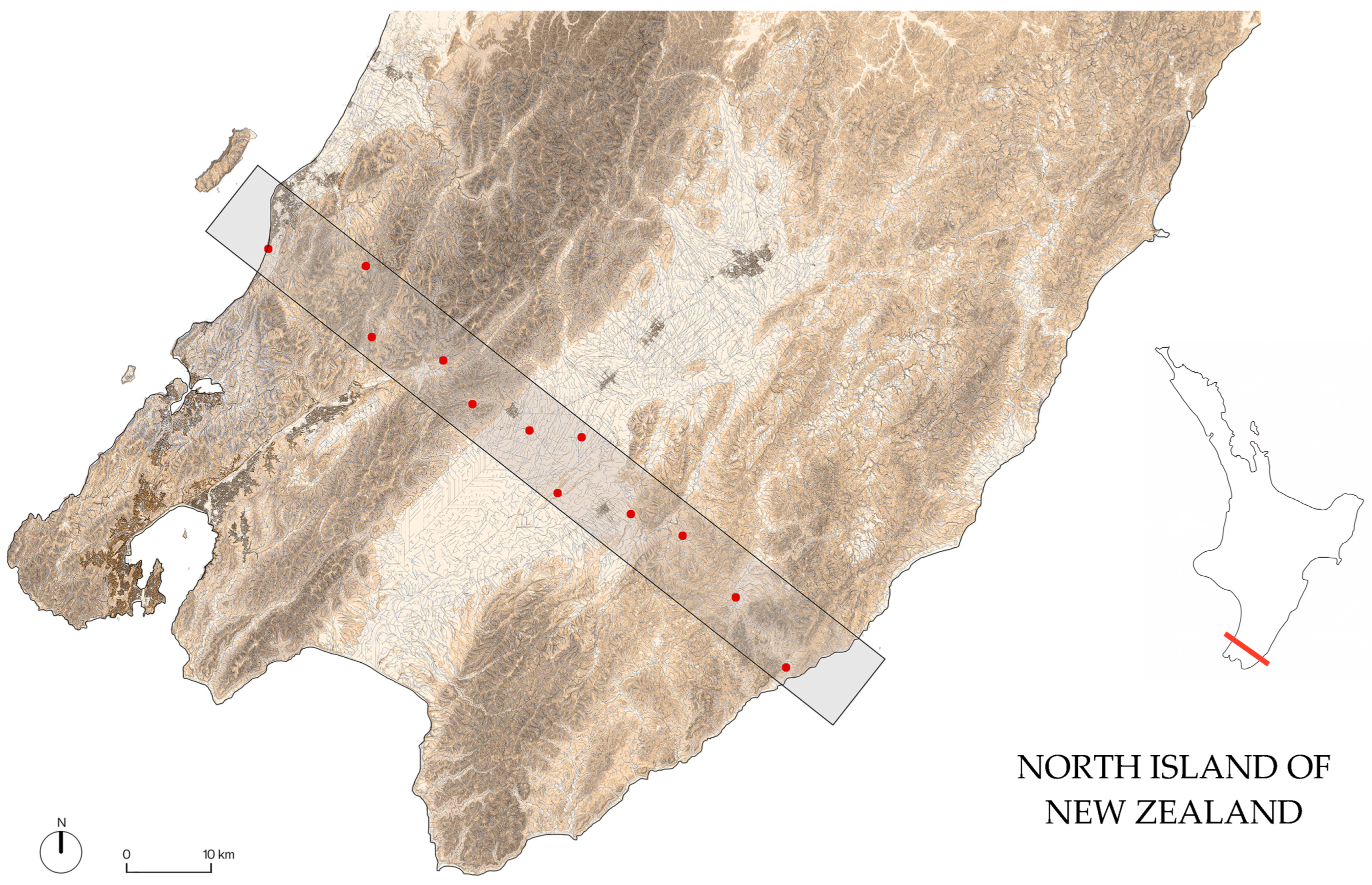
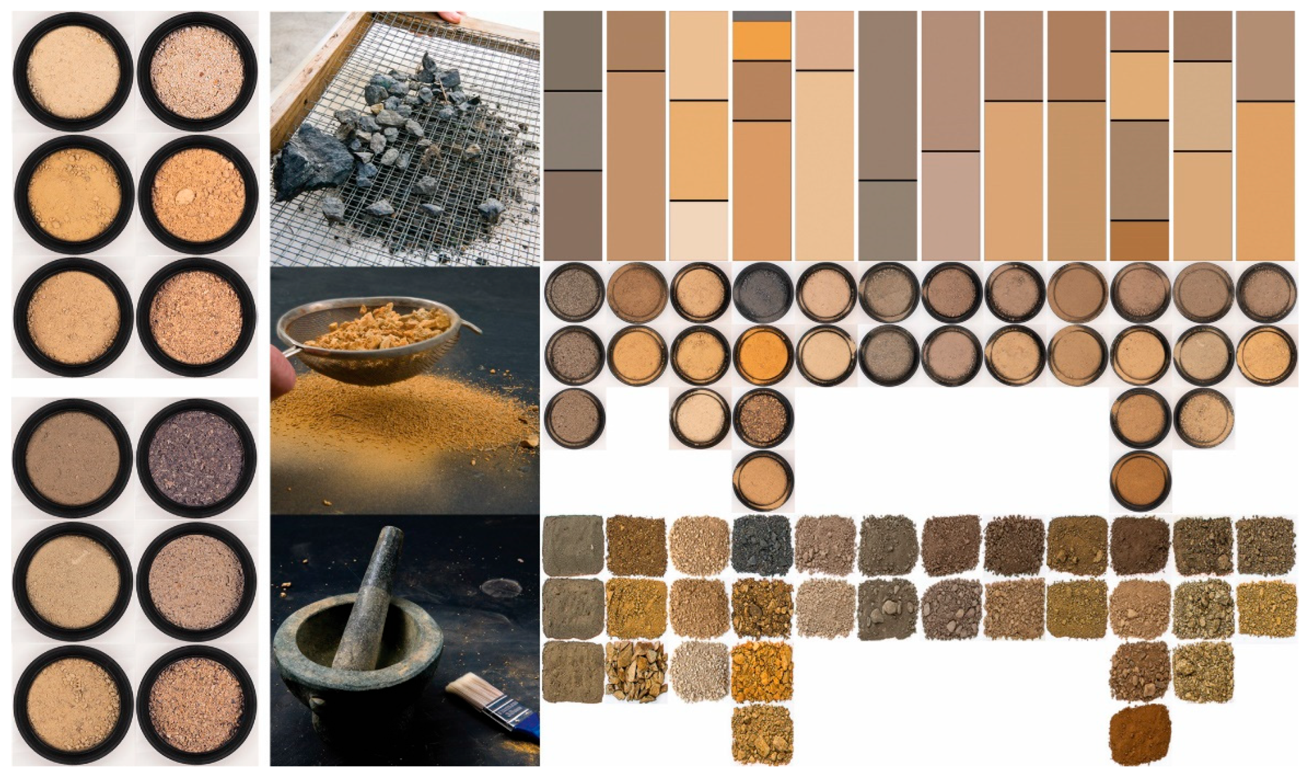
3.1. Soil Sampling and Analysis

The overall site location was determined by its proximity to Wellington, the potential for a coast-to-coast sample as well as the location of three periurban centres within which to reflect on place identity.
A transect approximately 10 km wide and 90 km long was established across the Wellington region of Aotearoa New Zealand, spanning from the Tasman Sea to the Pacific Ocean (Figure 1). Twelve soil extraction points were selected along this transect, aiming for roughly equidistant spacing, and their locations were geolocated using GIS software [53,54,55]. Site selection prioritised accessibility and even distribution along the transect to capture a representative sample of the region’s diverse soil types [56].
To ensure consistency among samples and for comparison with other categorisation systems, soil sampling followed established protocols [56,57], with a key modification: prioritising deeper sampling to capture a more complete soil profile. While typical soil sampling for agricultural or contamination studies often focuses on the top 15 cm, this research targeted a minimum depth of 1 m and often extended to 2 m or more where conditions permitted. This deeper sampling was crucial for revealing the full sequence of soil horizons and their distinct characteristics, which were central to the exhibition design.
The sampling depth was recorded at each location, noting instances where physical constraints such as bedrock or impenetrable layers limited extraction. To minimise contamination, samples were collected at least 10 m from any water body or structure. Subsoils were extracted from the uphill side of road cuts or other pre-existing land cuts whenever possible, utilising existing exposures to minimise environmental disturbance. The surrounding landscapes were documented through photographs, and a tape measure was used to record the depth of each soil horizon. Vegetation and any organic debris were excluded from the samples. Where horizons contained large rocks, smaller representative samples were extracted, and the in situ conditions were photographed. All samples were obtained from public land with uncontested ownership or private land with explicit permission from the landowner.
Once collected, the soils and subsoils were spread on paper sheets and air-dried without applying heat to preserve their natural characteristics (Figure 2). Each horizon was then individually characterised and analysed using the GLOBE protocol [58], focusing on three key properties relevant to visual and tactile perception: colour, structure, and texture.
  • Colour: Assessed using Munsell Colour system under natural light. Challenges in matching subtle hues and the need for dry, powdered samples highlighted the limitations of standardised charts for capturing chromatic richness. A systematic documentation protocol involving photographing samples at three moisture levels was developed to capture colour shifts [59].
  • Structure: Assessed visually and manually (sieving, aggregate identification), categorised using systems like USDA [60,61,62,63].
  • Texture: Assessed via hand-texturing to estimate sand/silt/clay proportions [64,65,66].
While standard soil science protocols would typically emphasise comprehensive chemical and physical analysis, our research deliberately focused on the visually and tactilely perceptible properties of soil that most directly influence aesthetic experience and place identity. This methodological choice reflects our research aim: not to produce a pedological survey, but to explore how soil’s sensory qualities can be effectively communicated through exhibition design to enhance public appreciation of soil’s role in regional distinctiveness.

3.2. Exhibition Design and Curation

Based on the data collected from the soil analysis, four distinct exhibitions were curated to explore different facets of the relationship between soil and regional identity. Each exhibition approach was designed to address specific challenges identified in previous soil exhibitions: revealing invisible processes, connecting scientific data to sensory experience, and fostering emotional connections to soil as a foundation of place identity. The design of each exhibition was informed by principles of effective science communication and museum exhibition design [9,11], aiming to create engaging and informative experiences for diverse audiences.
Two Window Display Exhibitions: “Soils Notation” (December 2022–February 2023) and “A Matter of Proportion” (December 2023–September 2024), held in the Te Wāhanga Waihanga-Hoahoa Window Gallery in Wellington, focused on visualising soil properties through different representational strategies. “Soils Notation” explored the visual language of soil, using photographs and soil profiles to highlight colour and texture, addressing the challenge of translating scientific soil data into accessible visual formats for public engagement. “A Matter of Proportion” translated soil horizon depths into architectural proportions, applying these proportions to the facades of existing buildings, thereby making concrete connections between soil structure and built environment—a relationship often overlooked in discussions of regional identity.
Lightbox Exhibition: “Horizons Revealed” (December 2023–November 2024), displayed in the Te Aro Pōnēke Wellington City Light Boxes, presented large-format photographs of soil profiles, emphasising both aesthetic qualities (“soil flowers”) and scientific details (colour, texture, and structure). The use of both colour and black-and-white photography aimed to highlight different aspects of the soil’s visual properties, while the public location of these lightboxes strategically brought soil imagery into everyday urban spaces, challenging the typical invisibility of soil in city environments.
Gallery Exhibition: “A Site to Behold” (5–12 November 2022), held in the Te Auaha Gallery in Wellington, offered the most comprehensive exploration of the topic, incorporating a variety of media, including physical soil samples (in tubes and resin casts), photographs, maps, and informative posters. Interactive elements, such as a soil sample box, which viewers were encouraged to arrange, photograph and share on social media, were included to encourage visitor engagement. This comprehensive approach was designed to engage multiple learning styles and demonstrate how various representation methods can reveal different aspects of soil’s contribution to regional character and identity.

4. Case Study Exhibitions: Material Explorations of Soil and Place

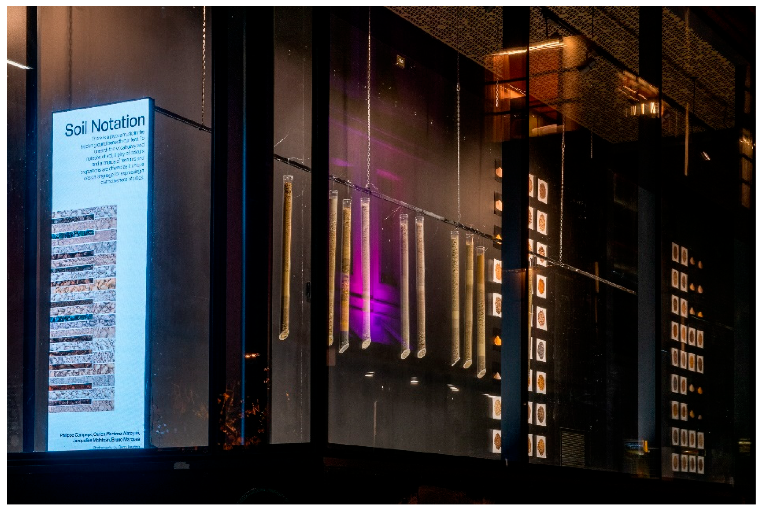
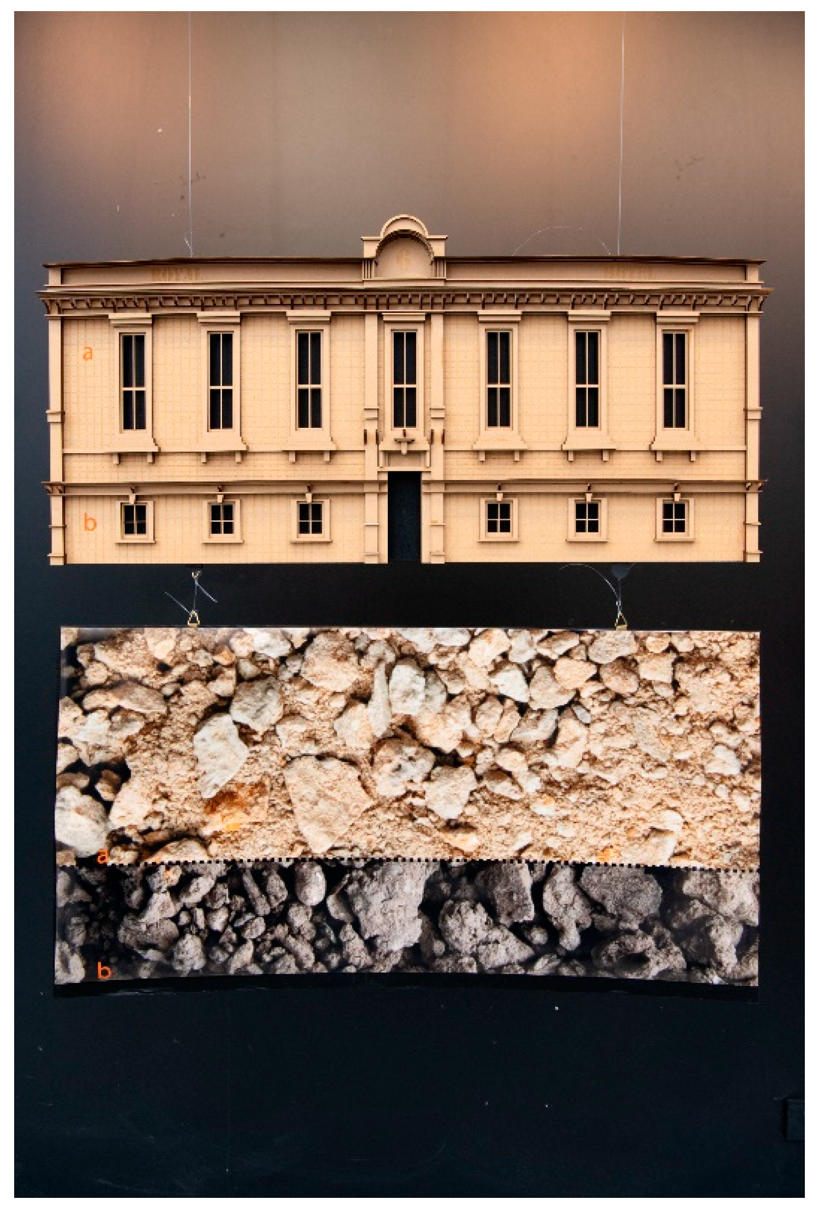
4.1. Window Display: Soils Notation (December 2022–February 2023)

The first exhibition, “Soils Notation” (Figure 3), explored soil as a visual language, drawing parallels to musical notation. It aimed to reveal the inherent vocabulary and notation of soil through its diverse colours, textures, and proportions, showcasing these elements as a unique design language that expresses the distinctiveness of a specific location. To illustrate this, the 1.5 m deep and 8 m long window display area incorporated photographs of soil elevations and plans, highlighting the different compositions of soil, such as sand, silt, and clay.
In addition, soil profiles were encased in transparent acrylic tubes, revealing the actual horizons and their development over time. Each soil profile was recreated in a flexi glass tube at a 1:1 scale. Where two horizons join, the texture of the soils of each was matched, so coarse grain with coarse grain and fine grain with fine grain. The depth of each horizon provides a unique proportioning system specific to that location. A variety of techniques and media were explored to reveal the beauty of the hidden soil layers.
The “Soils Notation” exhibition employed a deliberate methodology that merged scientific analysis with aesthetic interpretation. Rather than presenting soil as merely geological material, it was approached it as a complex visual language with its own grammar and vocabulary. Utilising principles from musical notation theory—rhythm, tempo, measure, and harmony—the vertical stratification of soil horizons was translated into visual compositions with interpretive depth.
The decision to use transparent acrylic tubes for soil profile representation emerged from extensive experimentation with various display methods. While traditional soil monoliths use adhesives that alter the natural appearance of soil particles, our approach preserved the authentic visual qualities by containing rather than binding the soil. This maintained scientific integrity while enhancing aesthetic appreciation. The 1:1 scale representation was critical to our methodology, as it allowed visitors to experience the actual proportional relationships between horizons rather than schematic or idealised versions.
The exhibition was grounded in pedological science, ensuring that the artistic representations remained faithful to the actual characteristics of the soils while highlighting key scientific processes, including the weathering processes specific to New Zealand’s unique volcanic and sedimentary parent materials.
“Soils Notation” created measurable shifts in visitor perception and understanding. Through observation and informal interviews with visitors, we documented increased dwell time at the exhibition compared to typical window displays in the area. Visitors frequently commented on their surprise at the aesthetic qualities of soil and reported new awareness of soil as a complex, layered system rather than a homogeneous substance.
The exhibition successfully functioned as a research instrument by testing our hypothesis that soil horizon proportions could be effectively translated into a visual language accessible to non-specialists. The consistent feedback from both design professionals and general audiences confirmed that the proportional relationships between horizons were readily perceived and interpreted as a form of location-specific “signature”—validating our approach of using soil as a foundation for regional design languages.

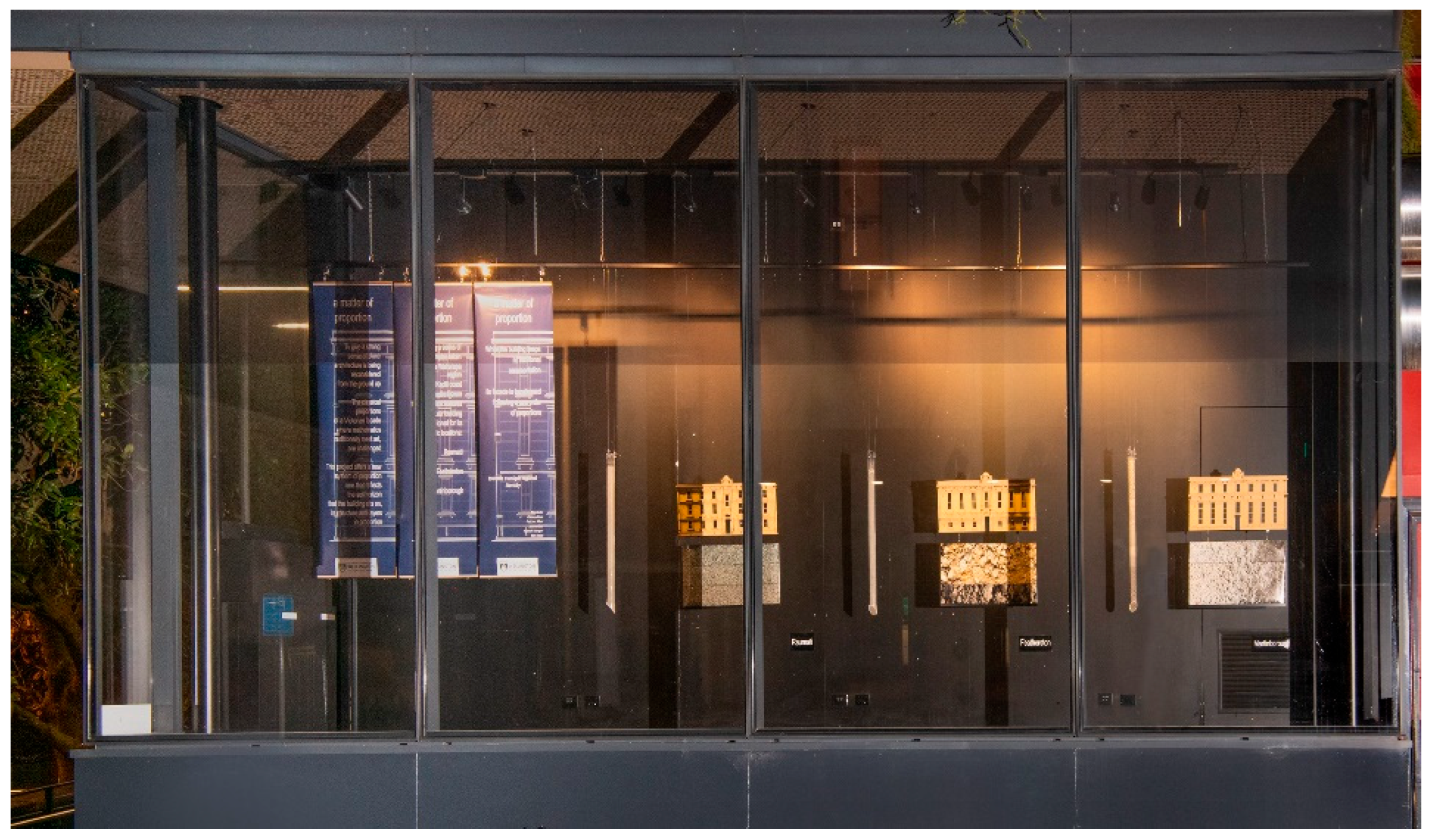
4.2. Window Display: A Matter of Proportion (December 2023–September 2024)

The second exhibition, “A Matter of Proportion” (Figure 4), focused on translating soil horizon proportions into architectural design. It explored the potential of horizon depths as a basis for building proportioning systems. The exhibition used a common New Zealand pub hotel, a building typology often sponsored by beer companies, as a starting point. The hotel’s façade proportioning systems were then modified to reflect the soil proportions found in three distinct locations: Raumati, Featherston, and Martinborough within the greater Wellington regional transect. This demonstrated how different soil compositions might influence architectural design to acknowledge regional place identity.
This display consisted of a photograph of the hotel typology placed in the front window for reference (Figure 5). Three explanatory banners provided context for the exhibition. Additionally, laser-cut 3D facades of each redesigned hotel were paired with a soil tube illustrating the corresponding soil proportions. These soil panels were constructed using a mix of wood, paper, and acrylic tubes. The laser-cut bas-relief facades and soil panels were approximately 0.5 m × 0.25 m × 400 mm. The overall goal of these exhibitions was to educate and raise awareness of soils as a potential design language or tool, targeting students, practitioners, and the general public.
To give a strong sense of place architecture is being reconsidered from the ground up. The classical proportions of a Victorian facade, where mathematics traditionally meets art, are challenged. This project offers a new system of proportion, one that reflects the soil horizon that the building sits on, its structure and layers in proportion. Following a series of soil samples taken across the Wairarapa region from the Kapiti coast to the Pacific Ocean. This exhibition features a singular building reproportioned for its specific location: Raumati, Featherston, Martinborough. While the building keeps its traditional ornamentation and complicated details, its facade is transformed following a new order of proportions.
“A Matter of Proportion” represented a critical research phase where a systematic translation protocol that converted soil horizon depths to architectural proportioning systems was developed and tested. Each design decision balanced scientific accuracy with architectural feasibility. For example, the Featherston soil profile translated into a proportionally equivalent middle section of the façade, influencing window heights and spacing. This provided a concrete demonstration of how subsurface conditions could generate regionally distinct architectural expressions while maintaining functional integrity.
The choice of the New Zealand pub hotel typology was methodologically significant, as this building type has historically been reproduced with minimal regional variation across the country. By using a recognisable “standard” form as our baseline, the soil-derived modifications became more readily apparent to viewers, enabling them to directly perceive how regional soil differences might manifest in architectural expression.
This exhibition functioned as both research communication and a practical proof-of-concept. By physically manifesting the soil-to-architecture translation methodology, it moved beyond theoretical propositions to testable design outcomes. The comparative display format—juxtaposing soil tubes with corresponding architectural designs—allowed visitors to directly evaluate the validity of our translation approach. This generated valuable feedback on which aspects of the soil proportioning system were most readily perceived and which might require refinement.

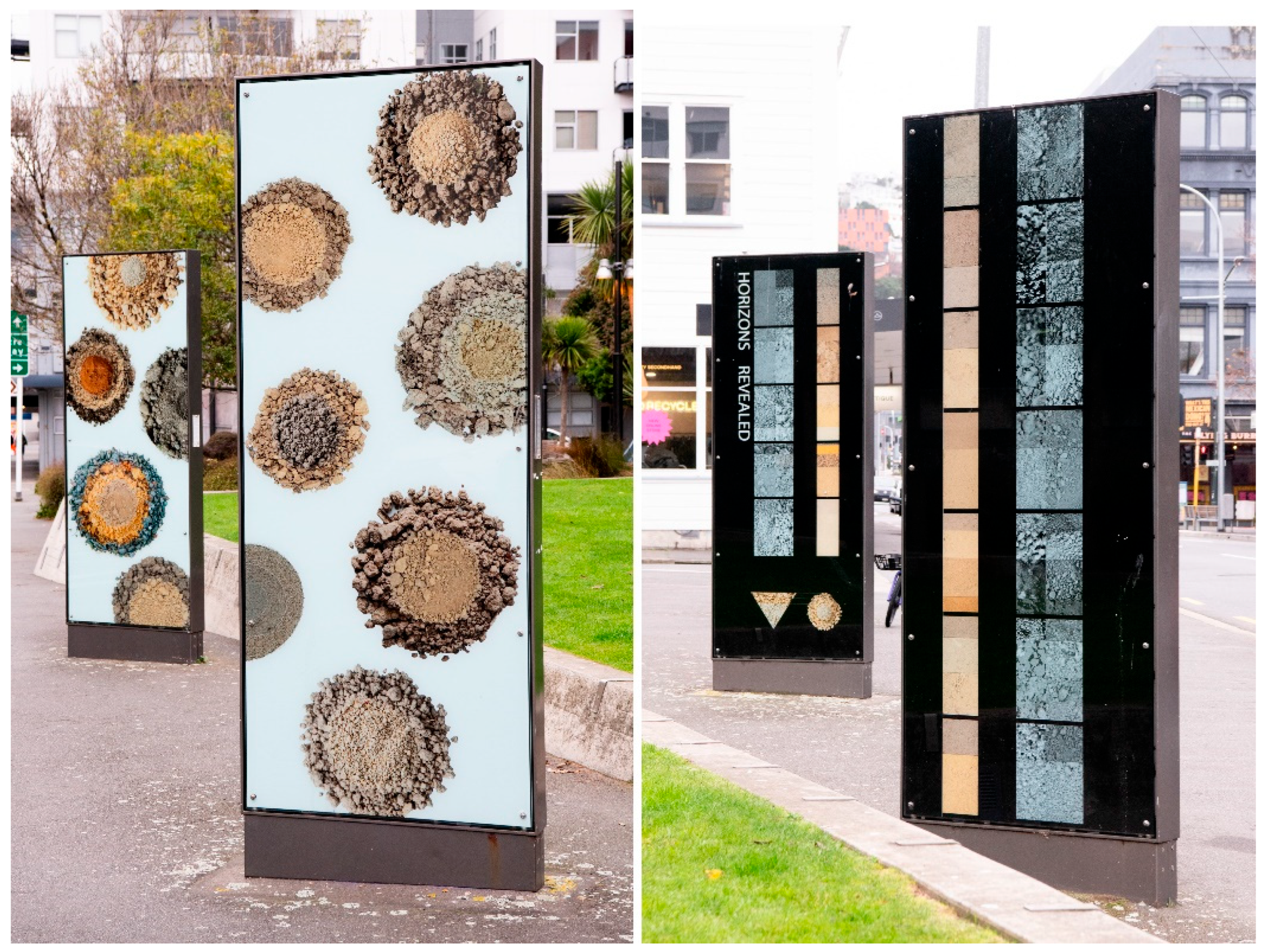
4.3. Lightbox Display: Horizons Revealed (December 2023–November 2024)

The lightbox exhibition “Horizons Revealed” (Figure 6), which ran from December 2023 to November 2024, delved into the captivating world of soil through two distinct investigative approaches. Two double-sided freestanding lightboxes, each measuring 2.5 m × 1 m, were positioned at a 45-degree angle in relation to the road.
The first approach explored soil profiles in plan and transformed the front of each lightbox into a canvas for showcasing the inherent beauty and diversity of soil. High-quality photographs captured soil cones arranged in a circular pattern reminiscent of a flower. This artistic presentation aimed to reveal the rich tapestry of colours, textures, and variations present in the soil, offering viewers an aesthetically engaging glimpse into the extracted earth.
The reverse side of the lightboxes, dedicated to soil textures and structures, provided a more scientific and analytical perspective. Each soil horizon was meticulously documented through a series of photographs designed to highlight specific characteristics. Colour photographs emphasised the hue and chroma, offering a nuanced understanding of the soil’s colour profile. In contrast, corresponding black and white photographs shifted the focus to the value (saturation) and texture of the soil. These images were presented in two forms: first in their natural state and then through digital abstraction, emphasising the inherent design potential embedded within the soil’s structure and composition.
By combining these two investigative approaches, “Horizons Revealed” offered a multifaceted exploration of soil. The exhibition, located along State Highway 2 at the intersection of Cuba and Vivian Streets in Wellington, aimed to explore the connection between soil and regional identity, arguing that soil is integral to a region’s identity and can inspire regionally specific architecture. Furthermore, the exhibition celebrated the aesthetic qualities of this often-overlooked material and provided insights into its inherent diversity and potential as a source of inspiration for design and artistic expression. Digital abstraction highlighted the design potential of soil. Ultimately, the exhibition aimed to educate and raise awareness about soil conservation and served as a reminder of the intricate connections between soil, place, and identity, encouraging viewers to reconsider their relationship with the ground beneath their feet.
“Horizons Revealed” employed innovative methodological approaches to soil visualisation that bridged scientific analysis and artistic interpretation. The decision to use lightboxes as the primary display medium was methodologically significant—the illumination technique allowed for unprecedented visualisation of soil characteristics that are typically difficult to perceive. This approach revealed subtle variations in soil opacity, translucency, and internal structure that conventional display methods cannot capture.
The exhibition’s dual presentation strategy (artistic/holistic and analytical/deconstructed) was deliberately designed to test how different visualisation approaches affect viewer comprehension of soil as both an aesthetic and scientific subject. The circular soil cone arrangements referenced botanical specimen displays, strategically positioning soil within familiar scientific visualisation frameworks to enhance accessibility for non-specialist audiences.
The scientific rigour underpinning the exhibition was evident in our application of standardised soil assessment methods. The paired presentation of colour and black-and-white photographs systematically isolated specific soil properties—hue and chroma in colour images, value and texture in monochrome—allowing visitors to analyse components that soil scientists evaluate separately according to the Munsell soil colour classification system. This methodological choice allowed the testing as to whether decoupling these visual properties enhanced viewer comprehension of soil structure and composition.
The digital abstraction component represented a methodological innovation in soil visualisation. By algorithmically processing soil texture photographs to extract pattern, rhythm, and textural features, a novel technique for identifying design-relevant characteristics that might otherwise remain imperceptible was developed. This process revealed recurring structural patterns specific to each soil type, providing new visual data on how regional soil characteristics might inform design languages.
The strategic placement of this exhibition along a major traffic route represented a methodological choice to test how soil visualisation might engage non-self-selected audiences. The comparison between artistic and analytical presentation approaches revealed that viewers reported a greater emotional connection to the aesthetic presentations but greater comprehension of the analytical displays. This finding has significant implications for soil science communication, suggesting that combined approaches may be most effective for public engagement with pedological concepts.

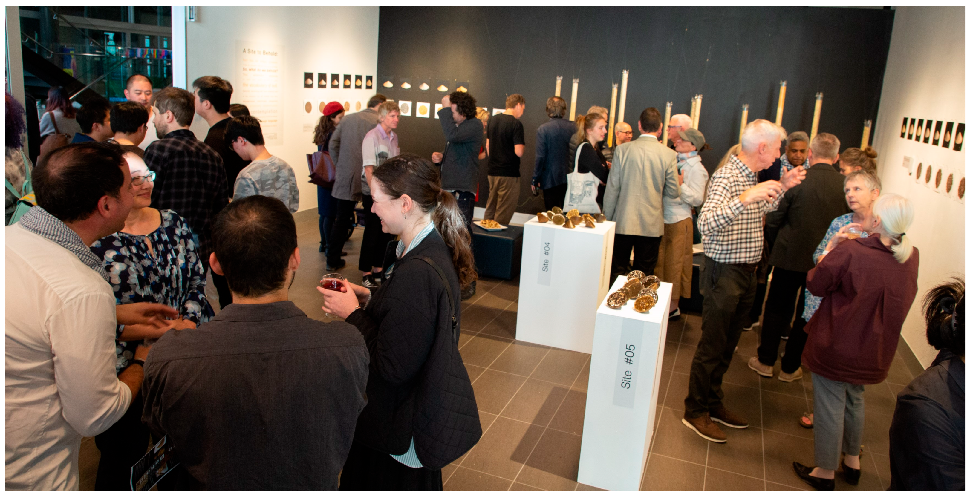
4.4. Gallery Exhibition: A Site to Behold (November 2022)

The gallery exhibition “A Site to Behold” (Figure 7), held at Te Auaha Gallery in central Wellington, provided a large-scale, dedicated space for a comprehensive exploration of soil and its relationship to place identity. The exhibition incorporated a diverse range of elements, including soil samples displayed in transparent tubes, three-dimensional objects cast in resin with embedded soil, photographic works, maps, and informative posters. Interactive elements, such as a soil sample box containing samples of soils with different textures and locations, encouraged visitor engagement and further exploration of the soil.
The exhibition aimed to reveal and examine the artistic potential of subterranean soil conditions in expressing unique regional identities and challenging contemporary trends in soil utilisation. For design professionals, it aimed to serve as a reference catalogue, showcasing hue, value, chroma, structure, proportionality, and texture for practical application. The exhibition demonstrated how curation could inform design decisions, fostering the development of an authentic regional aesthetic. The immersive presentation of the soil samples’ beauty and complexity prompted reflection and a reconsideration of the hidden inner world of soils, sparking a desire for alternative modes of understanding. This impact was evident anecdotally and documented in subsequent publications within landscape e-media and the New Zealand periodical Home.
In revealing the hidden layers of memory that compose our landscapes, the exhibition raised broader societal awareness about the importance of soils. As an integral part of the human-nature relationship and indispensable to the natural processes that allow life on Earth, this exhibit brought science and art together to explore formal aesthetic features, allowing visitors to connect with different states, agents, and media to understand the role soils have on our environment. Through its dimensions of time, space, and sensory experience, this exhibition triggered the viewer’s experience by bringing the physical and visual awe of land into a tight indoor architectural space and providing varied media and tools to explore the soil as a social and ecological subject.
“A Site to Behold” employed a multisensory research methodology that extended beyond visual representation to engage tactile, spatial, and temporal dimensions of soil experience. This comprehensive approach represented a methodological innovation in both soil science communication and architectural research by creating an immersive environment that allowed visitors to experience soil through multiple perceptual frameworks.
The resin-embedded soil samples represented a significant material experimentation component of our research. Through iterative testing of casting techniques, novel methods for preserving soil structure within transparent media while maintaining scientific accuracy were developed. This required precise control of resin viscosity, curing temperatures, and pouring sequences to prevent disruption of delicate soil aggregates. The resulting specimens offered unprecedented views of internal soil structures that normally collapse during excavation and handling, providing new insights into the three-dimensional architecture of soil that inform both scientific understanding and design inspiration.
The interactive soil sample box was methodologically significant as a tactile research instrument. By providing direct physical engagement with soil textures from different regions, we collected observational data on how haptic experiences influenced visitor perceptions of soil characteristics. This multisensory approach tested our hypothesis that embodied knowledge of soil through touch would enhance visual appreciation and comprehension of soil properties—a finding confirmed through informal post-interaction interviews.
The exhibition’s spatial organisation was deliberately structured as a research methodology, with visitors’ movement through the space following a sequence that paralleled the scientific process of soil investigation—from initial encounter with intact profiles, through analytical deconstruction of components, to synthesis and application. This spatial narrative tested whether structuring soil knowledge acquisition in this manner enhanced comprehension compared to non-sequential presentation.
“A Site to Behold” functioned as a comprehensive research platform that generated new knowledge about effective methods for translating soil science into accessible, engaging forms while maintaining scientific integrity. The exhibition’s impact extended beyond aesthetic appreciation to influence how soil is understood and valued across multiple disciplines.
Educational outcomes were measured through informal pre- and post-visit surveys with architecture and landscape architecture students, revealing increases in both soil knowledge and perceived relevance of soil to design practice. This finding directly challenges the conventional separation between subsurface conditions and architectural form in contemporary practice and education.

4.5. Exhibition Assessment

The effectiveness of each exhibition in communicating the soil’s role in regional identity was assessed through multiple approaches. Visitor engagement was documented through observation, photography, informal interviews, social media and web-based feedback using QR codes, focusing on the qualitative aspects of soil. Additionally, expert feedback was solicited from soil scientists and exhibition design professionals to evaluate both scientific accuracy and curatorial effectiveness. This multi-perspective assessment provided insights into how different exhibition approaches addressed the challenges of making soil visible and meaningful to diverse audiences. Two media publications (New Zealand periodical, ‘Home’ and landscape e-media) published favourable reviews of the event (ref).

5. Discussion

This research used exhibition design as a practice-based methodology to investigate how subsurface soil characteristics can inform understandings of place identity and potentially generate regionally specific design languages. The four exhibitions served as complementary platforms for developing, testing, and communicating methods for translating pedological data into sensory and architectural forms. Rather than merely documenting soil properties or exhibition techniques, this research has developed and tested a systematic methodology for translating pedological characteristics into architectural design languages that strengthen regional identity. The focused research inquiry underlying all four exhibitions was: How can soil profiles inform a regionally specific architectural language that strengthens place identity? This question addresses a significant gap in architectural theory and practice—the disconnect between geological site conditions and built form that has contributed to the homogenization of contemporary architecture across diverse landscapes.
The research proceeded in two distinct but interconnected phases: soil sampling and analysis, and exhibition design and curation. The soil analysis directly informed the exhibition design through a systematic translation methodology that moved from scientific assessment to visual representation and architectural application. This methodological approach represents the core research contribution of this work, establishing a replicable process for deriving design languages from pedological characteristics.

5.1. Soils Sampling and Analysis

5.1.1. Colour Analysis and Visual Communication

The Munsell colour analysis provided a precise vocabulary for describing and representing the diverse colours of the soil horizons. In the “Horizons Revealed” exhibition, the distinct colours of the soil profiles were a central visual element, arranged to resemble “soil flowers.” We found that to use the Munsell charts accurately, it was imperative that the soils be completely dried and ground to a fine powder to avoid textural shadows influencing the colour readings. Even then, the colours offered in the Munsell colour analysis were sometimes insufficiently refined to provide a perfect match, requiring us to select the closest available colour. This methodological challenge revealed a significant finding: standardised scientific colour classification systems, while valuable for technical documentation, present limitations when communicating the subtle chromatic richness of soil to non-specialist audiences.

5.1.2. Structure Analysis and Three-Dimensional Representation

The analysis of soil structure, including particle size distribution and aggregate formation, influenced the ways in which the soil was physically displayed. In the gallery exhibition (“A Site to Behold”), soil samples were displayed in transparent tubes to showcase the natural layering of horizons and the different structural characteristics of each layer. Resin casts were created to preserve and highlight the three-dimensional structure and porosity of selected soil samples, providing a tactile and visually engaging way for visitors to understand this property. This methodological innovation addresses a persistent challenge in soil science education: how to maintain structural integrity during sampling and display while providing visual access to internal characteristics.

5.1.3. Texture Analysis and Multisensory Engagement

The hand-texturing analysis, providing estimations of sand, silt, and clay content, informed the descriptive texts and labels used in the exhibitions, helping visitors understand the feel and behaviour of the different soil types. This analytical approach extended beyond visual representation to incorporate tactile engagement, testing our hypothesis that multisensory experiences enhance comprehension of soil properties. This finding suggests that conventional visual-dominant modes of soil representation may fail to communicate essential soil characteristics that influence both scientific understanding and design application.

5.1.4. Horizon Proportions and Architectural Translation

The measurements of horizon depths at each sampling site were directly translated into architectural proportions in the “A Matter of Proportion” window display. Soil proportions were applied to architectural form as well as elements, such as windows, doors and cornices, while respecting structural requirements. This created a direct link between the soil profile and the built environment, demonstrating how the “hidden” proportions of the soil could be made visible in architectural form. This translation methodology represents a significant research contribution of this work, establishing a systematic approach to deriving architectural proportioning systems from pedological structures.

5.2. From Soil Analysis to Exhibition Design and Curation

The exhibitions were designed to achieve shifts in visitor perception and understanding. We anticipated three primary outcomes:
  • Enhanced Visual Literacy: Visitors would develop an increased ability to “read” soil profiles and recognise distinctive regional characteristics.
  • Regional Identity Recognition: Participants would form new associations between soil properties and both local and potential architectural traditions.
  • Scientific Engagement: Non-specialist audiences would gain insight into pedological processes through aesthetic experience.
The development of effective soil exhibition techniques required overcoming several methodological challenges that yielded valuable insights for both soil science communication and architectural research. These challenges and our innovative solutions contribute substantively to knowledge in both fields.
First, preserving soil structural integrity during extraction, transportation, and display presented significant technical difficulties. Traditional soil monoliths use adhesives that alter the natural appearance of soil particles and often disturb natural horizon boundaries. We developed a non-invasive containment method using custom-designed acrylic tubes that maintained scientific accuracy while enhancing aesthetic appreciation.
Second, effectively representing soil colour proved challenging due to limitations in standardised colour systems and the influence of moisture content and lighting conditions on perceived colour. We developed a systematic colour documentation protocol that involved photographing samples under controlled lighting at three moisture levels (air-dried, field capacity, and saturated). This methodology revealed how dramatically soil colours shift with moisture content—an important finding for architectural applications where weathering and seasonal variations influence material appearance.

5.3. Limitations and Exhibition Comparison

This research faces several limitations related to the scientific knowledge involved in experimental design. No formal evaluation of visitor engagement or learning outcomes was conducted for these exhibitions, which represents a significant limitation of the research. The interdisciplinary nature of combining soil science, architecture, and public engagement meant working across disciplinary boundaries where standardised approaches for measuring effectiveness do not exist. While the exhibitions were documented through photographs and anecdotal feedback was gathered, as well as third-party reporting in both media publications and periodicals, no systematic methods were employed to assess visitor understanding, engagement, or changes in their perceptions of soil and place. The evaluation gap was partly due to resource constraints but also reflects the broader challenge of developing appropriate assessment tools for this type of interdisciplinary multi-media public engagement.
Additionally, the scientific understanding of how different exhibition formats influence public perception of soil–place relationships remains underdeveloped in the literature. This knowledge gap limited our ability to design controlled comparisons between exhibition types or predict which design elements would be most effective for different audiences. The research was also constrained by the absence of validated metrics for measuring ‘sense of place’ or ‘soil awareness’ in exhibition contexts.
Future research should incorporate evaluation methods such as visitor surveys or interviews to assess the effectiveness of different exhibition design strategies in communicating the relationship between soil and place identity. Despite this limitation, each exhibition type offered unique strengths and weaknesses in its ability to communicate the connection between soil and regional identity:
  • Window Displays: “Soils Notation” and “A Matter of Proportion” offered high visibility and accessibility to a broad public, effectively communicating a simple message quickly. Their concise nature and potential for strong visual impact were advantageous. However, the limited space restricted the depth of information and opportunities for visitor interaction, and the surrounding environment and reflections from adjacent building lighting can potentially distract from the exhibition’s message.
  • Lightbox Display: “Horizons Revealed” benefited from high-quality visuals and a dual focus on aesthetic and scientific aspects, also offering good public accessibility. The limitation of this form of exhibition was its two-dimensional engagement. A QR code placed on the side of the lightbox display provided subsequent information about the research and how one might engage with soil.
  • Gallery Exhibition: “A Site to Behold” allowed for the most comprehensive exploration of the topic, incorporating diverse media and providing a richer, multi-sensory curated experience. The controlled gallery environment also allowed for better control over contextual factors. However, gallery exhibitions typically have more limited accessibility and can potentially overwhelm visitors with information if not carefully curated.
Leveraging exhibition design as a powerful tool to cut through information overload and distil messages to their essence, this research employed thoughtful curation and effective communication techniques to showcase unique local soil characteristics. These exhibitions served dual roles as research instruments and communication platforms, aiming to foster a deeper understanding of place and promote an authentic regional aesthetic rooted in the very earth beneath our feet. In doing so, they facilitated knowledge exchange, community engagement, and artistic expression, while generating new insights into effectively linking subsurface conditions with built form. By raising public awareness about the crucial importance of soil-to-place identity, environmental stewardship, and shaping our sense of place, these earthbound spaces acted as sensory footholds—grasping points against larger forces—ultimately demonstrating the potential for an architecture capable of creating uniquely rooted places.

6. Conclusions

Sustainable design requires responding to the ‘spirit of place,’ encompassing biological, geological, and cultural contexts. This research contributes by demonstrating a methodology for deriving architectural language directly from subsurface soil characteristics, offering a tangible way to connect built form to the land upon which it rests.
Through four distinct exhibition formats, we explored techniques for making the complexities of soil visible and sensorially engaging, translating scientific analysis into aesthetic and architectural propositions. The exhibitions aimed to bridge the gap between scientific knowledge and public awareness, challenging views of soil as mere “dirt” and highlighting its foundational role in shaping regional identity and fostering a sense of belonging.

Author Contributions

Conceptualization J.M.; methodology J.M., B.M. and P.C.; formal analysis J.M. and B.M., investigation J.M., B.M., P.C. and C.M.-A.; data curation J.M., B.M., P.C. and C.M.-A.; writing—original draft preparation P.C.; writing—review and editing J.M. and B.M. All authors have read and agreed to the published version of the manuscript.

Funding

This research was funded through the Research Trust of Victoria University of Wellington, Project 400031 Faculty of Architecture and Design Innovation Research Support.

Data Availability Statement

The original contributions presented in this study are included in the article. Further inquiries can be directed to the corresponding author.

Acknowledgments

We would like to acknowledge Rawiri Smith (Ngāti Kahungunu ki Wairarapa and Rangitāne o Wairarapa) for his valuable insights into the matters of soil. We would like also to acknowledge Gerry Keating, our photographer from Victoria University of Wellington’s image services.

Conflicts of Interest

The authors declare no conflicts of interest.

References

  1. Altman, I.; Low, S.M. (Eds.) Place Attachment; Springer: Boston, MA, USA, 1992; ISBN 978-1-4684-8755-8. [Google Scholar]
  2. Baker, A.; Marques, B. Out of Place: Rewriting the Signatures of a Landscape. Spaces Flows Int. J. Urban Extra Urban Stud. 2017, 8, 1–12. [Google Scholar] [CrossRef]
  3. Brown, B.; Perkins, D.D.; Brown, G. Place Attachment in a Revitalizing Neighborhood: Individual and Block Levels of Analysis. J. Environ. Psychol. 2003, 23, 259–271. [Google Scholar] [CrossRef]
  4. Cresswell, T. Place: A Short Introduction; Blackwell Pub: Malden, MA, USA, 2004; ISBN 978-1-4051-0671-9. [Google Scholar]
  5. Craul, P.J. Urban Soils: Applications and Practices; Wiley: New York, NY, USA, 1999; ISBN 978-0-471-18903-9. [Google Scholar]
  6. Hashemnezhad, H.; Heidari, A.A.; Hoseini, P.M. “Sense of Place” and “Place Attachment”. Int. J. Archit. Urban Dev. 2013, 3, 5–12. [Google Scholar]
  7. Guy, S.; Farmer, G. Reinterpreting Sustainable Architecture: The Place of Technology. J. Archit. Educ. 2001, 54, 140–148. [Google Scholar] [CrossRef]
  8. Peet, R. Culture, Imaginary, and Rationality in Regional Economic Development. Environ. Plan. Econ. Space 2000, 32, 1215–1234. [Google Scholar] [CrossRef]
  9. Wilson, M.J. The Importance of Parent Material in Soil Classification: A Review in a Historical Context. Catena 2019, 182, 104131. [Google Scholar] [CrossRef]
  10. Birkeland, P.W.; Birkeland, P.E.G.P. Soils and Geomorphology; Oxford University Press: Oxford, UK, 1999; ISBN 978-0-19-507886-2. [Google Scholar]
  11. Minke, G. The Properties of Earth as a Building Material. In Building with Earth; Birkhäuser: Basel, Switzerland, 2006; pp. 19–35. ISBN 978-3-7643-7477-8. [Google Scholar]
  12. Bui, Q.-B.; Morel, J.-C.; Tran, V.-H.; Hans, S.; Oggero, M. How to Use In-Situ Soils as Building Materials. Procedia Eng. 2016, 145, 1119–1126. [Google Scholar] [CrossRef]
  13. Antrop, M. Why Landscapes of the Past Are Important for the Future. Landsc. Urban Plan. 2005, 70, 21–34. [Google Scholar] [CrossRef]
  14. Manifesto for Living in the Anthropocene, 1st ed.; Gibson, K., Rose, D.B., Fincher, R., Eds.; Punctum Books: Brooklyn, NY, USA, 2015; ISBN 978-0-9882340-6-2. [Google Scholar]
  15. Bell, S. Landscape: Pattern, Perception and Process; Routledge: London, UK, 2012; ISBN 978-0-203-12008-8. [Google Scholar]
  16. Herrmann, D.L.; Schifman, L.A.; Shuster, W.D. Widespread Loss of Intermediate Soil Horizons in Urban Landscapes. Proc. Natl. Acad. Sci. USA 2018, 115, 6751–6755. [Google Scholar] [CrossRef] [PubMed]
  17. Marques, B.; Freeman, C.; Carter, L.; Pedersen Zari, M. Sense of Place and Belonging in Developing Culturally Appropriate Therapeutic Environments: A Review. Societies 2020, 10, 83. [Google Scholar] [CrossRef]
  18. Feld, S.; Basso, K.H. Senses of Place; School of American Research Advanced Seminar Series; Boydell & Brewer, Ltd.: Rochester, NY, USA, 1999; ISBN 978-0-85255-900-0. [Google Scholar]
  19. Devine-Wright, P.; Clayton, S. Introduction to the Special Issue: Place, Identity and Environmental Behaviour. J. Environ. Psychol. 2010, 30, 267–270. [Google Scholar] [CrossRef]
  20. Richer-de-Forges, A.C.; Lowe, D.J.; Minasny, B.; Adamo, P.; Amato, M.; Ceddia, M.B.; Dos Anjos, L.H.C.; Chang, S.X.; Chen, S.; Chen, Z.-S.; et al. A Review of the World’s Soil Museums and Exhibitions. In Advances in Agronomy; Elsevier: Amsterdam, The Netherlands, 2021; Volume 166, pp. 277–304. ISBN 978-0-12-824587-3. [Google Scholar]
  21. Arefi, M. Non-place and Placelessness as Narratives of Loss: Rethinking the Notion of Place. J. Urban Des. 1999, 4, 179–193. [Google Scholar] [CrossRef]
  22. Relph, E. Place and Placelessness; Research in Planning and Design; Pion: London, UK, 2008; ISBN 978-0-85086-176-1. [Google Scholar]
  23. Agnew, J.A. Space and Place. In The SAGE Handbook of Geographical Knowledge; SAGE Publications Ltd.: London, UK, 2011; pp. 316–330. ISBN 978-1-4129-1081-1. [Google Scholar]
  24. Dean, D. Museum Exhibition: Theory and Practice; Routledge: London, UK, 2002; ISBN 978-0-203-03936-6. [Google Scholar]
  25. McIntosh, J.; Marques, B.; Martinez Almoyna, C.; Campays, P. Searching for Identity: Finding the Expression of Place under Ground. J. Urban. Int. Res. Placemaking Urban Sustain. 2023, 1–20. [Google Scholar] [CrossRef]
  26. Latva-Somppi, R. Soil Laboratory: Crafting Experiments in an Exhibition Setting. In Expanding Environmental Awareness in Education Through the Arts; Fredriksen, B.C., Groth, C., Eds.; Landscapes: The Arts, Aesthetics, and Education; Springer Nature: Singapore, 2022; Volume 33, pp. 213–229. ISBN 978-981-19485-4-1. [Google Scholar]
  27. Xylander, W.E.R.; Zumkowski-Xylander, H. Increasing Awareness for Soil Biodiversity and Protection the International Touring Exhibition “The Thin Skin of the Earth”. Soil Org. 2018, 90, 79–94. [Google Scholar] [CrossRef]
  28. Worster, D. The Wealth of Nature: Environmental History and the Ecological Imagination; Oxford scholarship online; Oxford University Press: New York, NY, USA, 2020; ISBN 978-0-19-509264-6. [Google Scholar]
  29. Keeler, B.L.; Hamel, P.; McPhearson, T.; Hamann, M.H.; Donahue, M.L.; Meza Prado, K.A.; Arkema, K.K.; Bratman, G.N.; Brauman, K.A.; Finlay, J.C.; et al. Social-Ecological and Technological Factors Moderate the Value of Urban Nature. Nat. Sustain. 2019, 2, 29–38. [Google Scholar] [CrossRef]
  30. Massey, D.B. Space, Place, and Gender, 6th ed.; University of Minnesota Press: Minneapolis, MN, USA, 2009; ISBN 978-0-8166-2617-5. [Google Scholar]
  31. Batty, M. Inventing Future Cities; The MIT Press: Cambridge, MA, USA; London, UK, 2024; ISBN 978-0-262-54865-6. [Google Scholar]
  32. Jang, K.M.; Chen, J.; Kang, Y.; Kim, J.; Lee, J.; Duarte, F.; Ratti, C. Place Identity: A Generative AI’s Perspective. Humanit. Soc. Sci. Commun. 2024, 11, 1156. [Google Scholar] [CrossRef]
  33. Puig De La Bellacasa, M. Re-Animating Soils: Transforming Human–Soil Affections through Science, Culture and Community. Sociol. Rev. 2019, 67, 391–407. [Google Scholar] [CrossRef]
  34. Obrist, H.U. Formulas for Now; Thames & Hudson: London, UK, 2008; ISBN 978-0-500-23850-9. [Google Scholar]
  35. Obrist, H.U.; Lamm, A.E.; Sehgal, T.; Friedman, Y. Everything You Always Wanted to Know About Curating: But Were Afraid to Ask; Sternberg: New York, NY, USA; Berlin, Germany, 2011; ISBN 978-1-933128-25-2. [Google Scholar]
  36. Obrist, H.U.; Bovier, L. A Brief History of Curating; Documents Series, 9. Aufl. JRP Ringier: Zürich, Switzerland, 2018; ISBN 978-3-905829-55-6. [Google Scholar]
  37. Obrist, H.U. Ways of Curating, 1st American ed.; Faber and Faber: New York, NY, USA, 2014; ISBN 978-0-86547-819-0. [Google Scholar]
  38. Hooper-Greenhill, E. Museums and Education; Routledge: London, UK, 2007; ISBN 978-1-134-18169-8. [Google Scholar]
  39. Weil, R.R.; Brady Late, N.C.; Weil, R.R. Nature and Properties of Soils, 15th ed.; Pearson Education: London, UK, 2016; ISBN 978-0-13-349336-8. [Google Scholar]
  40. Ingold, T. The Perception of the Environment; Routledge: London, UK, 2002; ISBN 978-1-134-58566-3. [Google Scholar]
  41. Howes, D. Empire of the Senses: The Sensual Culture Reader; Sensory Formations; Berg Publishers: Oxford, UK, 2005; ISBN 978-1-85973-863-4. [Google Scholar]
  42. Bladholm, S. Soils, Seeds, and Sprouts: Tropical and Temperate; Sharon Bladholm: Chicago, IL, USA, 2022; ISBN 979-8985400908. [Google Scholar]
  43. Montgomery, D.R. Dirt: The Erosion of Civilizations; University of California Press: Berkeley, CA, USA, 2007; ISBN 978-0-520-24870-0. [Google Scholar]
  44. Latour, B.; Weibel, P. Critical Zones: The Science and Politics of Landing on Earth; ZKM Center for Art and Media: Karlsruhe, Germany; The MIT Press: Cambridge, MA, USA, 2020; ISBN 978-0-262-04445-5. [Google Scholar]
  45. Hooper-Greenhill, E. Museums and Education: Purpose, Pedagogy, Performance; Museum meanings; Routledge: London, UK; New York, NY, USA, 2007; ISBN 978-0-415-37935-9. [Google Scholar]
  46. Wessolek, G.; Toland, A. Exploring the Artistic Dimensions of Soils in the Vadose Zone. Vadose Zone J. 2024, 23, e20308. [Google Scholar] [CrossRef]
  47. Moscatelli, M.C.; Marinari, S. Digging in the Dirt: Searching for Effective Tools and Languages to Promote Soil Awareness. Soil Secur. 2024, 16, 100167. [Google Scholar] [CrossRef]
  48. Parry, R. (Ed.) Museums in a Digital Age; Routledge: London, UK, 2013; ISBN 978-0-203-71608-3. [Google Scholar]
  49. Macdonald, S. (Ed.) A Companion to Museum Studies; Blackwell Companions in Cultural Studies, 1., Aufl.; John Wiley & Sons: New York, NY, USA, 2011; ISBN 978-1-4443-5794-3. [Google Scholar]
  50. Jenny, H. Factors of Soil Formation: A System of Quantitative Pedology; Dover books on earth sciences; Dover: New York, NY, USA, 1994; ISBN 978-0-486-68128-3. [Google Scholar]
  51. Schinner, F.; Öhlinger, R.; Kandeler, E.; Margesin, R. Methods in Soil Biology; Springer: Berlin/Heidelberg, Germany, 2012; ISBN 978-3-642-60966-4. [Google Scholar]
  52. Candy, L. Practice Based Research: A Guide; Creativity & Cognition Studios, University of Technology: Sydney, Australia, 2006; p. 19. [Google Scholar]
  53. Thornton, J. The Reed Field Guide to New Zealand Geology: An Introduction to Rocks, Minerals and Fossils; Reed: Wellington, New Zealand, 2003; ISBN 978-0-7900-0856-1. [Google Scholar]
  54. Hewitt, A.E.; Balks, M.R.; Lowe, D.J. The Soils of Aotearoa New Zealand; World Soils Book Series; Springer International Publishing: Cham, Switzerland, 2021; ISBN 978-3-030-64763-6. [Google Scholar]
  55. Webb, T.H.; Lilburne, L. Criteria for Defining the Soil Family and Soil Sibling: The Fourth and Fifth Categories of the New Zealand Soil Classification. Landcare Res. Sci. Ser. 2011, 3, 1–39. [Google Scholar]
  56. Schoeneberger, P.J.; Wysocki, D.A.; Benham, E.C. Field Book for Describing and Sampling Soils; National Soil Survey Center Natural Resources Conservation Service, U.S. Department of Agriculture: Lincoln, NE, USA, 2012; p. 298. [Google Scholar]
  57. Soil Survey Staff. Field Book for Describing and Sampling Soils; U.S. Department of Agriculture Natural Resources Conservation Service: Washington, DC, USA, 2024; p. 312. [Google Scholar]
  58. GLOBE. Soil Characterization Protocol: Field Guide; GLOBE: New York, NY, USA, 2014. [Google Scholar]
  59. Color, M. Munsell Color (Blog). Available online: https://munsell.com (accessed on 20 April 2022).
  60. Soil Survey Staff. Keys to Soil Taxonomy; USDA Natural Resources Conservation Service: Washington, DC, USA, 2017. [Google Scholar]
  61. Phogat, V.; Tomar, V.; Dahiya, R. Soil Physical Properties. Soil Sci. Introd. 2015, 6, 135–171. [Google Scholar]
  62. Osman, K.T. Soils: Principles, Properties and Management; Springer: Dordrecht, The Netherlands, 2012; ISBN 978-94-007-5663-2. [Google Scholar]
  63. Thompson, J.A.; Pollio, A.R.; Turk, P.J. Comparison of Munsell Soil Color Charts and the GLOBE Soil Color Book. Soil Sci. Soc. Am. J. 2013, 77, 2089–2093. [Google Scholar] [CrossRef]
  64. Viscarra Rossel, R.A.; Minasny, B.; Roudier, P.; McBratney, A.B. Colour Space Models for Soil Science. Geoderma 2006, 133, 320–337. [Google Scholar] [CrossRef]
  65. Hoorman, J.J. Understanding Soil Microbes and Nutrient Recycling. Agric. Nat. Resour. 2010, SAG-16, 1–5. [Google Scholar]
  66. Marshall, T.J. Particle-Size Distribution of Soil and the Perception of Texture. Soil Res. 2003, 41, 245. [Google Scholar] [CrossRef]
Figure 1. Plan of the Wellington region showing the orientation, location and dimensions of the transect as well as the extraction points in red.
Land 14 01346 g001
Figure 2. Soil Analysis. (Photography: Gerry Keating).
Land 14 01346 g002
Figure 3. Soils Notation (Photography: Gerry Keating).
Land 14 01346 g003
Figure 4. A Matter of Proportion (Photography: Gerry Keating).
Land 14 01346 g004
Figure 5. A Matter of Proportion close-up (Photography: Gerry Keating).
Land 14 01346 g005
Figure 6. Horizons Revealed (Photography: Gerry Keating).
Land 14 01346 g006
Figure 7. A Site to Behold (Photography Gerry Keating).
Land 14 01346 g007
Table 1. Comparison of exhibition approaches and their treatment of soil–place relationships.
Exhibition/Project NameVisibility of Soil ProcessesConnection to Sensory ExperienceRegional Identity EmphasisAudience EngagementScientific-Artistic Balance
Soils Notation (2022–2023) & A Matter of Proportion (2023–2024)
New Zealand
Visual representation through photography and diagrams; translation of soil horizon depths into architectural proportionsPrimarily visual; connects soil morphology to built environment proportionsConnects soil horizons to local architectural elementsAccessible to casual passers-by; integrates soil awareness into daily urban experienceEmphasises artistic interpretation of scientific measurements
Horizons Revealed (2023–2024)
New Zealand
Large-format soil profile photographs with colour and black-and-white presentationsStrong visual emphasis on aesthetic qualities (“soil flowers”)Places soil profiles directly in public spaceHigh visibility in public spacesBalances scientific accuracy with aesthetic presentation
A Site to Behold (2022)
New Zealand
Physical samples, resin casts, photographs, maps, and postersMultisensory, tactile engagement with soil samplesConnects soil types to local landscapes and cultural practicesInteractive elements encourage direct engagementComprehensive scientific information alongside artistic elements
Underground: Soils, Seeds, and Sprouts (Bladholm & Notebaert, 2017)
Chicago, USA
Focus on ecological functions and agricultural importanceEmphasises universal soil propertiesLimited focus on regional identityPrimarily educationalWeighted toward scientific communication
Critical Zones Exhibition (Latour & Weibe, 2021)
Germany
Focus on political and ecological relationshipsMultimedia approach emphasising interconnectionsPositions soil within global political systemsIntellectually engagingArtistic presentation of scientific/philosophical concepts
Soil Matters (Latva-Somppi, 2020)
Finland
Combines artistic, craft, and scientific methods; includes soil analysisMultisensory (tactile, visual, participatory)Strong regional focus (Nordic soils, Venetian landscapes)High engagement through workshops and live lab workStrong balance of science and craft practices
Soils Project (SFS, TarraWarra Museum of Art and Van Abbemuseum, 2023)
Australia and the Netherlands
Explores impacts of farming, mining, colonisation, and land management on soil and cultural heritage. Addresses cultural memory related to specific landscapes.Primarily visual (photography, installation) and conceptual, focusing on landscape histories and impacts rather than direct soil sensation.Explicitly connects specific locations (Wurundjeri Country, Australia; Yogyakarta, Indonesia; Eindhoven, Netherlands) exploring their distinct histories, environments, and knowledges.Collaborative research initiative involving artists, activists, curators, academics. Included webinars, workshops, exhibitions, festival aiming for dialogue and exchange.Involves artists, activists, and research institutions, exploring agrarian struggles, ecological justice, cultural heritage, land management through artistic and research practices.
SOIL: The World at Our Feet (Somerset House, London, January–April 2025) UKAims to show ‘life below ground,’ microbial life, mycelium networks. Includes scientific artefacts and micro-photography to make the invisible visible.Explicitly combines “sensory artworks,” sound installations (microbial life recordings), micro-photography, and digital projections alongside objects.Features global artists and thinkers addressing universal themes of planetary health. While individual works may have regional roots, the overall focus is not on one region.Includes events, activities, educational section, opportunities for visitor response (post-it notes), shop, café offers. Aimed to inspire, educate, and promote action.Explicitly brings together global artists, writers, musicians, and scientists. Combines artworks, historical objects, scientific artefacts, and documentary evidence. Co-curated by artists and curators.
Save Land: United for Land (Bundeskunsthalle, Bonn, December 2024–June 2025) GermanyFocuses on soil formation, land degradation rates, links to climate change, resource consumption (city supply chains). Presents scientific findings.Described as “immersive,” using videos, spatial installations, archaeological finds, and artworks to make the topic “emotional and tangible.”Addresses global issues (G20 Land Initiative) but uses specific examples (German cities, Peruvian artist/maize). Themes allow for regional exploration within a global context.Aims to raise awareness, encourage action, and foster a “shift in thinking” by making complex scientific information accessible and emotional through art.Explicitly presents scientific findings together with diverse artistic media (video, installation, art, archaeology). Collaboration between G20 GLI and an art museum.
Un/Making Soil Communities (Åsa Ståhl and Kristina Lindström, 2018)
Finland
Participatory phytoremediation workshops Interactive planting and storytellingStrong regional ties (Sweden, Finland)Co-creative with localsBlends design research, ecology, and art
Disclaimer/Publisher’s Note: The statements, opinions and data contained in all publications are solely those of the individual author(s) and contributor(s) and not of MDPI and/or the editor(s). MDPI and/or the editor(s) disclaim responsibility for any injury to people or property resulting from any ideas, methods, instructions or products referred to in the content.

