Article

Sacrificing Wilderness for Renewables? Land Artificialization from Inadequate Spatial Planning of Wind Energy in Evvoia, Greece

by
Vassiliki Kati
1,*,
Konstantina Spiliopoulou
2,
Apostolis Stefanidis
1 and
Christina Kassara
1
1
Department of Biological Applications & Technology, University of Ioannina, 45110 Ioannina, Greece
2
Department of Biology, National and Kapodistrian University of Athens, 15772 Athens, Greece
*
Author to whom correspondence should be addressed.
Land 2025, 14(6), 1296; https://doi.org/10.3390/land14061296
Submission received: 2 May 2025 / Revised: 28 May 2025 / Accepted: 13 June 2025 / Published: 17 June 2025

Abstract

:
The REPowerEU Plan calls for a massive speed-up of renewable energy, which can undermine nature conservation. We explored the impact of an industrial-scale wind power project planned inside a Natura 2000 site (Special Protected Areas for birds) in the mountains of Central Evvoia, in Greece. If approved, the project could cause significant land artificialization, land take, and habitat fragmentation, having a land take intensity of 4.5 m2/MWh. An important part of forested land (14%) would be artificialized. The wilderness character would sharply decline from 49% to 4%, with a large roadless area (51.4 km2) shrinking by 77% and a smaller one (16.1 km2) lost. The project greatly overlaps with the Natura 2000 network (97%), a regional Key Biodiversity Area and Important Bird Area (84%), and a potential Global Key Biodiversity Area (27%). It might affect 23 globally threatened and 44 endemic species. This case study is a typical example of the poor implementation of the Natura 2000 and EIA legislation and highlights their recurring inability to prevent harmful human activities across Europe from affecting protected species of European interest and ecosystem functions. We conclude with policy recommendations to help increase renewables’ sustainability and minimize land artificialization in the EU.

1. Introduction

Human activities have accelerated climate change and biodiversity loss, resulting in a cascade of synergistic events that disrupt the natural world and threaten human and ecosystem health [1,2]. To avert climate change and biodiversity loss and “live in harmony with nature,” governments have been committing to fulfill the two interlinked global targets by reducing greenhouse emissions and improving energy efficiency, as well as by restoring ecosystems and effectively protecting biodiversity [3,4,5,6,7].
Transitioning to Renewable Energy Sources (RES) has been one of the key strategies in the frame of the Paris Agreement [4], as RES reduce greenhouse gas emissions and have lower operational and environmental costs compared to traditional fuel-based systems [8,9,10,11]. RES deployment is progressing more rapidly in the European Union (EU), which aims to achieve climate neutrality by 2050 in the frame of the European Green Deal [12] through a set of legally binding targets. These include the reduction of net greenhouse gas emissions by at least 55% (EU Climate Law) [7] and achieving a 42.5–45% renewable energy share in the EU’s overall energy consumption by 2030 (Renewable Energy Directive) [13]. At the same time, the EU Biodiversity Strategy for 2030 [6] and the recent Nature Restoration Regulation (NRR) [5] came to complement the EU Birds [14] and Habitats Directives [15], which underpin the implementation of the Natura 2000 network—the largest network of protected areas for the conservation of species and habitats in the EU. This body of nature conservation legislation aims to halt and reverse the dramatic biodiversity decline reported in Europe [16]. Ambitious measures are foreseen for nature conservation and restoration in the EU, including protecting 30% of EU land and sea, designating one-third of these areas under strict protection status, restoring 30% of the annexed habitats currently in poor condition alongside forest and agricultural ecosystems, improving the conservation status of species, and restoring pollinators’ populations. Therefore, the challenge lies in harmonizing the two key policies—green energy development and nature conservation—by ensuring that renewable energy expansion is truly sustainable [17,18].
However, the REPowerEU Plan [19] signaled an imbalance in the two policies. It called for a massive speed-up and scale-up in RES deployments to reduce the EU’s energy dependence on Russia’s fossil fuels. It led to a revised Renewable Energy Directive (RED III) [20] with provisions prioritizing RES deployment over nature conservation. Before the REPowerEU Plan, the competent authorities could approve a project only when it would undoubtedly not adversely affect the protected interests of Natura 2000 sites. In a few cases, an exemption could be provided for implementing harmful projects for “overriding public interest.” This status has now been assigned to all RES projects by RED III [20], and the exemption might turn into a norm, potentially leading to systematic derogations from the EU Birds [14] and Habitats [15] Directives. A special provision for RES is also included in the Nature Restoration Regulation [5], allowing such projects of overriding public interest under two conditions: (a) RES projects must comply with the Strategic Environmental Assessment (SEA Directive) [21], which serves as an early broad-scale spatial planning tool that integrates a range of socioeconomic, environmental, and other relevant criteria to minimize projects’ impacts; and (b) RES projects must have been subject to an Environmental Impact Assessment (EIA), which assesses the project’s cumulative direct and indirect effects on human health, biodiversity, land, water, air, climate, and cultural heritage at a site-specific level (EIA Directive) [22,23]. Therefore, high-quality spatial planning at a broad scale through SEA, combined with rigorous local-scale EIAs accounting for cumulative impacts [24], is imperative and seems to be the only viable path to reconcile renewable energy development with nature conservation goals and to resolve the current policy conflicts.
The wind energy sector is one of the leaders in the green energy transition in Europe, making up 19% of all the electricity consumed by 27 countries, primarily attributed to onshore wind harnessing [25]. Although the land footprint of wind turbines is considered among the lowest compared to other energy types [26], wind harnessing in ecologically sensitive areas with high biodiversity value, such as wilderness and protected areas, raises environmental concerns [27,28,29,30,31]. Despite the multiple benefits of wind energy, its adverse environmental impacts are not negligible, and careful spatial planning is imperative [32], especially when protected areas are involved [33].
Wind power facilities are projected to cause significant land use change in Europe, requiring about 400,000 km2 of agricultural and natural land by 2050 [34]. Land use change is the principal cause of global biodiversity decline [35]. It undermines the capacity of natural ecosystems to sequester carbon and maintain biodiversity, creating a feedback loop that intensifies global warming [36]. Although land use change is mainly associated with natural land conversion to agricultural land in the tropics [37], land conversion to artificial surface is probably its most detrimental and often non-irreversible form for ecosystem functions and biodiversity [38]. Land artificialization, land consumption, or land take is defined as converting any natural or semi-natural land to artificial surfaces over time [38,39]. Artificial land encompasses a broad range of land cover types, including (a) sealed surfaces such as urban fabric, buildings, paved roads, and industrial and commercial units; (b) non-sealed surfaces consisting of compacted or heavily disturbed soils, such as dirt roads, railways, construction sites, mines, dumps, and sport and leisure facilities; and (c) non-sealed surfaces covered by heavily altered or artificial vegetation, such as green urban areas, sport and leisure parks, and other artificially vegetated areas. In this study, we use the term land artificialization to refer to all three categories (a-b-c). The term land take is used specifically for categories (a) and (b), while soil sealing pertains exclusively to category (a).
This study assesses the impact of an industrial-scale wind power project inside a Natura 2000 site in Greece. The country is among the most attractive global markets for wind energy investments [40], and the wind energy sector is developing fast. According to the Regulatory Authority for Energy database, 2829 wind turbines operate nationally, totaling 4.8 GW [41]. According to Wind Europe [25], the country has reached 5.35 GW of installed GW power capacity by the end of 2024, with a share of the wind power mix of 22%, exceeding the European average. Thus, Greece has already achieved 54–60% and 37–41% of the onshore wind capacity installation target by 2030 (8.9 GW) and 2050 (13 GW), respectively, as dictated by the National Energy and Climate Plan [42]. However, the country stands as a typical conflict terrain [27] and a policy imbalance paradigm enhancing the energy transition at the expense of biodiversity, recognized in the last national environmental performance review by the Organisation for Economic Co-operation and Development [43]. The report clearly acknowledged the ambitious energy transition to 2030 in Greece, but it underscored the need to improve monitoring and integration of biodiversity in economic sectors, pinpointing that urbanization and fragmentation are the main drivers of biodiversity loss and noting that half of the species in Greece are in unfavorable status.
We consider here as a case study a project of 11 wind power stations and 98 wind turbines planned in the mountains of central Evvoia. Evvoia is the second largest island of Greece that currently hosts 17% (823 MW) of the national wind energy power installed and one-fifth (598 wind turbines) of the total number of operating wind turbines [41], being industrialized mainly in its southern part (Figure 1). The island has recently suffered destructive, unprecedented megafires, such as a megafire burning 510 km2 in its northern part in 2021 [44]. So far, the mountains of central Evvoia, where the wind power project has been planned, have remained unaffected by megafires and large-scale RES infrastructures. The EIA of the planned project, paid for and delivered by the investor through the commissioned consultant company ECOMIND, concluded that the project should be licensed for construction due to minor environmental effects [45]. Competent authorities, including the Archaeological Service, the Forest Service, and the Natural Environment and Climate Change Agency (NECCA), as well as regional and local governments and citizens, have contributed their opinions during the consultation process. The Directorate of Environmental Licensing, the competent authority within the Greek Ministry of Environment and Energy, will determine whether to approve or reject the environmental terms required for the project to proceed to the construction phase. We used the mountains of central Evvoia as a case study to answer questions of broader conservation and policy importance for land and natural resources preservation. We specifically explored the effect of the planned wind power project on (a) land use change and artificialization, (b) landscape fragmentation, and (c) wilderness area loss. We further investigated (d) the potential conflict of the project spatial configuration with ecologically sensitive zones that are legally protected or have the potential of legal protection and (e) the potential project impact on globally threatened species. The results of our study are discussed in a broader context for the implementation of the SEA and EIAs.

2. Materials and Methods

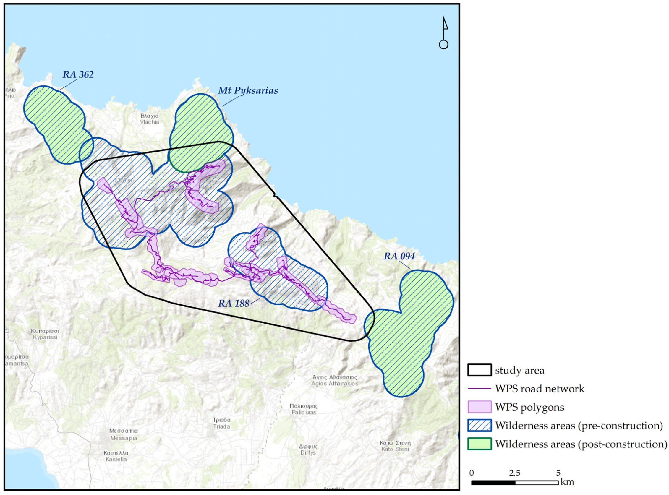
2.1. Study Area Delineation

The planned wind power project (hereafter, planned project) is located on Evvoia Island in Greece (Figure 1). It consists of 11 wind power stations (hereafter, WPS) corresponding to 21 polygons with 98 turbines totaling 279.6 MW of installed power, according to the project EIA Study [45] (Table S1). To delineate the study area, we first downloaded the installation polygons and related wind turbines from the National Regulatory Authority for Energy’s online database (15 September 2024) [41]. We then digitized the road network of new access roads based on the EIA maps [45]. Considering only the terrestrial part (excluding water bodies—Corine Land Cover 5.1) [46], we created a minimum convex polygon enclosing a buffer of one kilometer around the planned WPS polygons and the related new road network to be constructed. We adopted a conservative approach to define the buffer zone because our study focused on the land impact of WPS, and most road effects take place at a 1 km distance from the roads [47]. However, the effects of WPS, such as noise or visual effects, extend at a greater distance [48]. The resulting study area covers nearly 115 km2 (Figure 1, Table 1). It ranges from 0 to 1321 m (average elevation of 725 m) in the Mediterranean climate zone (mean annual temperature of 13 °C, mean annual rainfall of 605 mm). It consists mainly of forest (43%), followed by heathland and shrubs (28%), grasslands (16%), and sparsely vegetated areas (10%), while agricultural land and mining sites cover just 3% (Table 1). Broad-leaved evergreen scrubs, phrygana, and cultivations occur at lower altitudes; pine and fir forests at middle altitudes; and chestnut woodland and mountainous grasslands at higher altitudes [49].

2.2. Data Sets

We compiled a geospatial database for the study area considering the Greek coastline [50]. It comprised the WPS polygons [41] and the following datasets: (1) the road network in the study area by merging the existing road network provided by the Open Street Map data [51] with the digitized new road network based on the EIA provisions [45], (2) the national database of roadless areas [52], (3) the land cover classes after Corine typology [46] and respective ecosystem types defined by the MAES classification system [53], (4) the Natura 2000 network of protected areas [54], (5) the regional Key Biodiversity Areas (KBA) referring to an Important Bird and Biodiversity Area (IBA) [55], (6) the potential Key Biodiversity Areas (pKBA) [56], (7) the distribution range of all terrestrial species occurring Greece by their threat of extinction category (CR—critically endangered, EN—endangered, VU—vulnerable, NT—near threatened, LC—least concerned) using the IUCN Red List database [57], (8) the different protection zones suggested by the Special Environmental Study (hereafter SES) for the Natura 2000 sites in the study area [58] and (9) the recommended potential investment zone and the reciprocal exclusion zone for planting wind turbines in Greece according to a sustainable spatial planning scenario [59]. This scenario horizontally excluded wind power projects from the Natura 2000 network and areas of low landscape fragmentation while achieving the former national wind harnessing targets by 2030 [27].

2.3. Data Analysis

We first calculated the total land artificialization, including road surfaces and the WPS polygon area, encompassing all sealed and non-sealed surfaces with vegetated remnant patches. We estimated the average road width of new access roads by dividing the total road land take by road length, as referred to in the project EIA [45], resulting in an average width of c.a. 10 m (681,792 m2/66,682 m). We then applied a buffer of 10 m around the new access roads digitized to estimate the extent of the artificial surfaces generated by road construction outside the WPS polygons. We summed this area (road land artificialization) with the 21 WPS polygon area (WPS land artificialization) to calculate the total project land artificialization. We also estimated the land artificialization intensity as the ratio of the total artificial land generated over wind power installed (m2/MW) and annual power generation (m2/MWh), considering 8766 h per year and a capacity factor of 25%, using the equation MWh = MW × 1 25 %   × 8766 h [60].
We also estimated land take, i.e., artificial surfaces excluding those with vegetated remnant patches, and the relevant land take intensity (m2/MW and m2/MWh). Since the area of such surfaces is unknown and cannot be digitized at the pre-construction phase, we estimated it using the equation: L a n d   t a k e = A × 0.14 0.74 , where A was the total polygons’ area. The estimation was based on the observation that, in Greece, land take within WPS polygons averages 14% of each polygon’s area and accounts for 74% of total land take (with the remaining 26% occurring outside the WPS polygons) [60].
Second, we computed the overlap of the total artificial land generated (hereafter, intervention zone) with seven geospatial datasets considered (datasets 3 to 9).
Third, we assessed the anticipated landscape fragmentation for each MAES ecosystem type by computing the change in five metrics, number of patches, mean patch area, mean distance among patches within the study area, effective mesh size, and edge density, using the “landscapemetrics” 2.0.0 R package [61]. The effective mesh size is a metric of landscape fragmentation, representing the average size of unfragmented habitat patches; larger values indicate greater habitat connectivity by quantifying the probability that two randomly selected points lie within the same unobstructed patch [62]. Edge density quantifies the amount of edge among the different MAES ecosystem types per unit area. Higher edge density reflects greater exposure to edge effects [63].
Finally, we estimated the Roadless Fragmentation Index (RFI), referring to the cover proportion of roadless areas before and after the construction of the planned project [64]. To do so, we applied the methodology of the national roadless areas map [65]: we applied a buffer zone of 1 km around the WPS polygons and the total road network. We then calculated the remaining core roadless areas, referring to the patches over 1 km2 area located at least 1 km from the nearest road or WPS polygon. We applied the 1 km buffer around them and merged the resulting polygons to calculate the extent of the remaining roadless areas.
Road digitization, geospatial data preparation and analyses were implemented in ArcGIS 10.7 [66]. Effective Mesh Size and Mean Edge Density, were caclulated in R v.4.3.3 [67].

3. Results

3.1. Land Artificialization

Natural and semi-natural habitats cover 99% of the study area (97% natural habitats, 2% semi-natural habitats) based on MAES ecosystem types (Table 1). The planned project would cause a land artificialization of nearly 15 km2, corresponding to 13% of the study area, all referring to natural habitats (Table 1). The land artificialization index would be 53,112 m2/MW (or 24.2 m2/MWh). The estimated land take would be 2.75 km2, corresponding to 2.4% of the study area and a land take index of 9845 m2/MW (or 4.5 m2/MWh).
An important part of forested land would be artificialized (6.7 km2—14% of forests), with coniferous forests being the most affected (4.5 km2, accounting for 18% of coniferous cover). One-fourth of open ecosystems, 15% of natural grasslands, and a smaller proportion of heathlands and shrubs (8%) would also be artificialized. The new access roads outside the WPS polygons (15.27 km) would account for a road density of 133 m/km2 and a road intensity index of 54.6 m/MW. They would be constructed mainly within forests, heathlands, and shrubs, but their land take impact would be very low (Table 1).

3.2. Landscape Fragmentation

The planned project is expected to substantially fragment the natural landscape in the study area, while agricultural and urban land would remain intact (Table 2). It would generate more and smaller patches of natural vegetation, being slightly closer to each other, less well connected, and with increased edge boundaries. Fragmentation would mainly affect open, sparsely vegetated areas, generating over five times more patches that would have 10% of the initial patch size, and then forests, generating three times more forest patches that would have 30% of their initial size but be at a closer distance. The patches of sparsely vegetated areas and then forests would be less connected, and the edge effects would be more pronounced in forests (Table 2).

3.3. Wilderness Loss

The project greatly overlaps (64%) with the two roadless areas, considered wilderness areas (Table 2, Figure 2). The total cover of wilderness areas is going to be reduced from 55.9 km2 to 4.6 km2 in the study area, corresponding to a twelve-fold decline in roadless cover from 49% to 4% (RFI). The large wilderness area of Mt Pyksarias would be reduced to one smaller patch of 12 km2 (4.1 km2 within the study area) after the WPS construction, accounting for 23% of its initial size (51.4 km2). Moreover, a smaller wilderness area (16.1 km2) would be totally lost, but two vicinal roadless areas would not be affected (Figure 2).

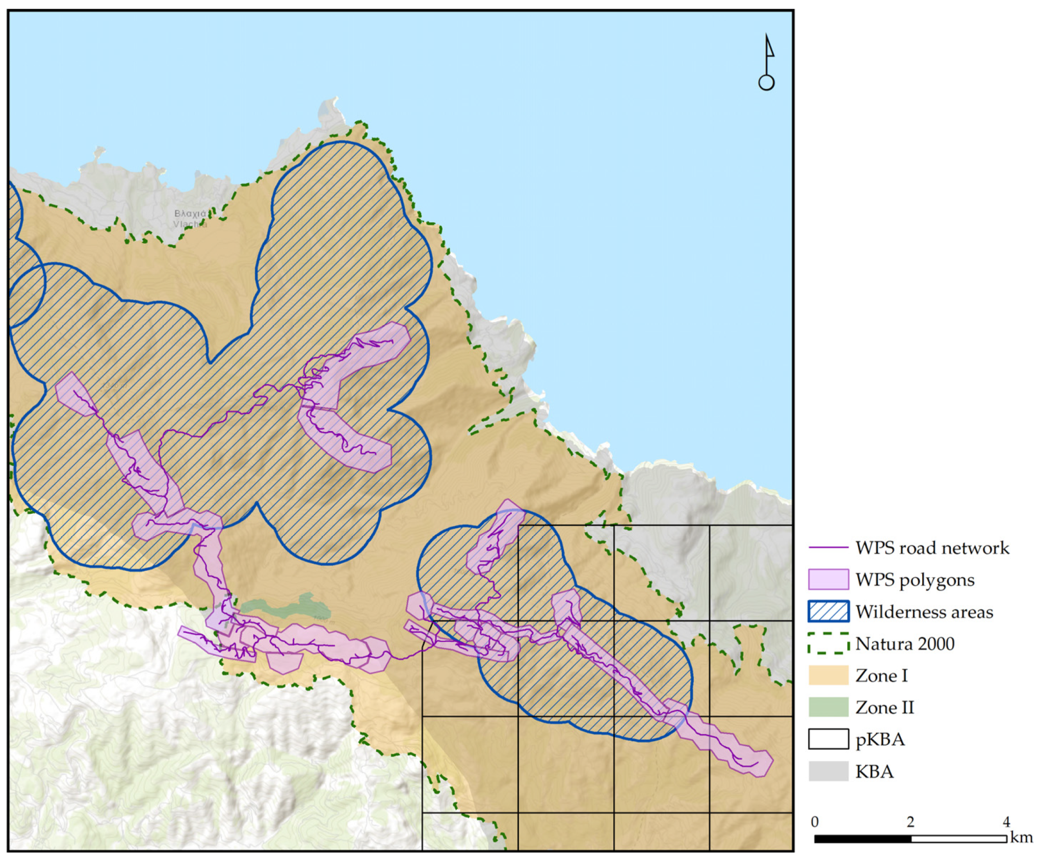
3.4. Ecologically Sensitive Zones

The planned project overlaps with many ecologically sensitive zones currently protected or fulfilling the criteria for potential protection (Table 2, Figure 3).
Nearly the entire intervention zone (97%) lies within the boundaries of the Natura 2000 site GR2420011 (Special Protected Areas—SPA: Ori Kentrikis Evvoias, Paraktia Zoni kai Nisides) (Table 3). The Natura 2000 site is designated under the Birds Directive and protects 31 bird species listed in its Annexes (Table S2). Furthermore, it falls almost entirely within the “Zone I-Nature Protection Zone,” where new road construction and land development are not allowed (except for energy transfer infrastructures in exceptional cases), according to the Special Environmental Study [58]. No overlap is noted with the “Zone II-Habitats and Species Conservation Zone”, where such infrastructures are allowed under specific conditions. The planned infrastructures also considerably overlap (84%) with the designated regional Key Biodiversity Area (KBA) “Mountains of Central Evvoia” (ID 1049) and to a lesser degree (27%) with a potential Key Biodiversity Area for multiple terrestrial taxa.

3.5. Red-Listed Species

According to the IUCN Red List of Threatened Species [57], 533 species occur in the study area, and the global distribution range of 524 species overlaps with the intervention zone: 351 animals (41 endemics), 161 plants (3 endemics), and 12 fungi. An overall number of 23 species are assessed as threatened with extinction: two critically endangered species (one endemic), six endangered species (three endemics), and 14 vulnerable species (four endemics). The remaining species are near threatened (30 species; four endemics), least concerned (428 species; 15 endemics), or data deficient (44 species; 17 endemics). The polygons covered a small part of the species’ global distribution range (average overlap 0.03%, max overlap 3.81%) (Table S3).

4. Discussion

4.1. Land Artificialization

Our results highlighted the high naturalness of the study area, reaching almost 100%, alongside the significant land artificialization due to the planned wind facilities that could reduce natural land by 13% (Table 1). The estimated land intensity of the project was high. Land take intensity estimates can differ by orders of magnitude due to inconsistent methodologies in the calculation, ranging from less than 1 m2/MW up to 13,500 m2/MW [68,69], but the global generic estimate for land take presented in the Global Land Outlook is 1 m2/MWh (2192 m2/MW) [26]. Therefore, the planned project is expected to incur a 4.5 times higher land take intensity (4.5 m2/MWh) than the global generic estimate, while the overall land artificialization intensity is even higher (24.3 m2/MWh). On the other hand, we found that the land impact of new access roads outside the installation polygons was limited, half the national average [60]. Still, land take intensity is an estimation since its accurate calculation requires post-construction digitization of new roads, road widening, turbine pads, control units, substations, disposal sites, etc.
The increased land impact of the planned project is attributed to the undeveloped character of the intervention zone, as the lack of prior infrastructure substantially increases the land footprint of wind facilities [60,68,70]. It is also attributed to the intervention zone’s forested character and harsh topography. Wind facilities planted in forests and shrublands have been found to have a greater land footprint than those in tilled landscapes [69], as well as those planted in steeper localities [60,70]. Access roads to wind facilities are important land consumers in Greece, with their land take increasing with harsher local topography and the absence of other infrastructures [60]. In our case study, the land take of roads was not substantial. Their negative impact is more related to fragmentation than land take per se, in line with other studies in Finland and the USA [70,71].

4.2. Landscape Fragmentation

We demonstrated that the planned wind project would significantly fragment the landscape if a construction license is eventually issued. It would shatter natural habitats into smaller and less connected patches, particularly affecting open, sparsely vegetated areas (Table 2). Landscape fragmentation increase deriving from wind energy facilities is also reported in other countries [70,71], though more quantitative studies are needed on this topic, given its significant negative impact on biodiversity and ecosystem function [72,73]. The number of species affected and the magnitude of their population decline will depend on their distribution patterns, spatial requirements, habitat preferences, and dispersal abilities. Such species loss can be immediate or time-delayed, known as the extinction debt [74]. Furthermore, the projected species loss at the patch scale (α-diversity) is documented as not being able to be recovered at the landscape scale (γ-diversity) [75].
We also found that forests would be the most vulnerable ecosystem exposed to edge effects and that about 18% of coniferous forests are projected to be lost in the study area. Although no habitat mapping is currently available, Greek fir forests (Abies cephalonica) are known to occur in the study area together with pines and thus will most probably be severely affected. The Greek fir is an endemic mountainous species (800–2000 m) with very restricted distribution in the country, forming a habitat of national importance (habitat type 951B) [49]. Fir clearing inside the WPS polygons and across access roads would be detrimental for this habitat. Besides habitat loss, edge effects would aggravate tree mortality due to microclimatic stress and wind exposure near roads [76]. The regeneration of the species would be hampered in the warmer microclimatic conditions among fragments, as the species favors shade and requires increased soil moisture to regenerate [77].

4.3. Wilderness Loss

Nearly half of the study area currently retains a wilderness character, which is expected to be almost entirely lost due to the planned project, as indicated by the dramatic decline of the Roadless Fragmentation Indicator (from 49% to 4%). An entire roadless area would disappear from the roadless map of Greece, while at the same time, Mt Pyksarias (51.4 km2), the 20th largest among the 451 roadless areas of the country [65], would be reduced to a smaller roadless patch (12 km2). The roadless areas of Greece constitute wilderness, marked by undevelopedness, undisturbedness, and naturalness that increase with their size; they resist land use change and are less prone to wildfires, yet one-third are now threatened by the nationwide expansion of the wind energy industry [60]. Such large roadless areas are increasingly recognized as reliable indicators of the world’s most pristine and functional ecosystems that should be urgently preserved [47,78]. Wind industry development might soon threaten other roadless ecosystems of wilderness character at a global scale [30], such as most roadless areas in the desert biome [79], which are among the most intact habitats on Earth [47].
In 2022, Greece became the first EU country to adopt roadless legislation through the “Untrodden Mountains” policy [80], provisionally granting strict protection to nine roadless mountains via ministerial decisions. This legislation banned roads and infrastructure development, acknowledging their adverse impacts on biodiversity, ecosystem services, and landscape values [81]. The government has declared its intention to protect additionally the 55 most pristine mountains as roadless areas in line with Sustainable Development Goal 15.4 for mountain conservation [82]. However, many pristine mountains, such as Mt Pyksarias in our study area, could face irreversible artificialization before implementing the roadless policy.

4.4. Ecologically Sensitive Zones

The inadequate spatial planning of the planned project is evinced by its high overlap with many ecologically sensitive zones (Table 3, Figure 3). We found that nearly all planned infrastructure falls within the Natura 2000 network of protected areas and, specifically, within Zone I (Nature Protection Zone), which the Special Environmental Study (SES) has designated as a strictly protected zone to enhance the conservation of EU-protected species [58]. The SES prohibits wind energy development and new road construction in this zone, aligning with the EU Biodiversity Strategy [6] and the related guideline [83], which recommends one-third of the protected areas be designated as non-intervention zones “left undisturbed from human pressures and threats” to safeguard biodiversity and natural environmental processes. Although the public consultation of the SES has been accomplished (October 2024), the SES output has not yet been legally ratified under a presidential decree defining the land uses across the zones of the Natura 2000 site. Such governmental delays allow harmful projects to proceed in some of Greece’s most ecologically valuable areas, in the absence of an enforceable legal framework, undermining the integrity and purpose of the Natura 2000 network. The case study in central Evvoia is a typical example of the poor implementation of the Natura 2000 legislation and highlights its recurring inability to prevent harmful human activities across Europe [84,85].
KBAs represent the largest network of sites globally important for safeguarding biodiversity [86]. Activities that negatively affect the species or ecosystems based on which a site holds its status as a KBA directly impact global biodiversity. The planned project is expected to affect a regional Key Biodiversity Area (KBA) that is not of global importance and is designated to protect the breeding range of Cretzschmar’s Bunting (Emberiza caesia). It might also impact a potential global KBA identified on the basis of three trigger species, all being endemic invertebrates with restricted distribution that are threatened with extinction [56]. RES development is recognized as an important threat to KBAs worldwide [30,31], and KBA maintenance is underlined as an important parameter for consideration in the cumulative impact assessment studies [24]. Although the country was the first in Europe to legally recognize KBAs in 2023, calling for 100% inclusion in protected areas by 2030 (Law 5037/2023), the delayed approval of the global KBAs of Greece and the subsequent delayed law enforcement undermines their protection from harmful human activities and developments, as exemplified by the current wind energy project.

4.5. Impact on Threatened and Important Species

According to our results, the ecological value of the intervention zone is high, hosting 44 endemic animal and plant species and 23 species threatened with extinction (8 endemics) according to the IUCN Red List [57]. Among them are the three trigger species contributing to the identification of a pKBA. The Dirphys Greek Bush-cricket (Parnassiana dirphys) is a short-winged, mountainous species found exclusively in central Evvoia, assessed as Vulnerable [87]. The Lucas’ Dark Bush-cricket (Pholidoptera lucasi) is also a mountain-dwelling Orthoptera occurring in central Evvoia and Thessaly, assessed as Endangered [88]. The snail Zonites euboeicus inhabits lower-altitude shrubby ecosystems only in central Evvoia and is assessed as endangered [89]. It is unknown whether and how the habitat loss and fragmentation deriving from the planned project would affect the trigger species and the other globally threatened species of the area. Species with limited dispersal abilities and very restricted ranges, such as endemic plants and flightless invertebrates, are considered to be the most vulnerable to local extinctions [90]. The overlap of the intervention zone with their distribution ranges was very limited, but species distribution ranges are broad areas representing the limits of occurrence, including areas of unsuitable habitats, rather than occupied habitats by the species [91]. Local population declines or even local extinctions are a matter of chance, depending on the spatial configuration of the suitable habitats occupied and how much of their extent will be artificialized. Although all endemic and threatened species are legally protected in Greece (Law 3937/31-3-2011), the knowledge gaps and the lack of habitat suitability maps impair law implementation. The legal provisions are usually overlooked, as was the case in the EIA of the current wind energy project [45]. The inclusion of threatened species in the EIAs and in the cumulative impact assessment studies is of crucial importance [24], given that the country is a biodiversity hotspot with a great degree of endemism and threatened species (761 species) [57,92,93].
Furthermore, the Appropriate Assessment Study for the annexed bird species of the EU Birds’ Directive that is part of the project EIA [45] acknowledges that the collision mortality with wind turbines would affect 16 raptor species, resulting in very significant (4 species), significant (2 species), and medium (10 species) impact (Table S2). Seven of them are included in Annex I of the EU Birds Directive, and the conservation objectives will be undermined for the short-toed snake-eagle (Circaetus gallicus), which has a population of 5 pairs in the broader study area (Table S2).

4.6. Impact on Ecosystem Functions

Although our study has not evaluated the project’s impact on ecosystem services, the increased land artificialization and fragmentation are recognized to have a cascade of adverse effects on ecosystem function. Land take directly disrupts nutrient cycling, water-holding capacity, soil fertility, carbon sequestration, biomass, and habitat provision, with these functions being even nullified under sealed soils [94]. In artificial lands, the process of converting living biomass into soil organic carbon is broken, and less or no new organic material can enter soils as organic carbon stock [95], with the greenhouse gas fluxes increasing [96]. Given that soils store more carbon than terrestrial vegetation and the atmosphere combined [97], the minimization of land take is pivotal in reducing the area available for future carbon sequestration and consequently hampering climate change impacts. Furthermore, fragmentation can cause species richness loss by 13–75%, community composition changes towards generalist and invasive species, population isolation increase, edge effects altering physical and microclimatic conditions, biomass reduction, and disruption of nutrient and carbon cycles, pollination, and food webs [73,98,99,100].
The ecosystem services of carbon removal from the atmosphere would be severely reduced through Greek fir cutting when accounting for the carbon sequestration rate of other fir species, such as Abies religiosa (carbon sequestration of 1.03 megagrams per hectare per year) [101]. In line with our results, the deforestation associated with WPS is known to be substantial and even greater than other infrastructures in Finland [71]. Such local deforestation cases contribute to the global problem: sitting WPS and solar panels solely where wind and solar resources are highest would result in the loss of 11 million ha of natural habitats, releasing almost 415 million tons of carbon storage, undermining biodiversity and climate targets [31].

4.7. The Role of SEA in Spatial Planning

The planned project exemplifies the severe impacts on nature deriving from the combined effect of poor-quality SEAs and EIAs. The project application should have been blocked at an early stage by SEA provisions. However, the current SEA [102] is outdated and of low quality, poorly integrates the environmental criteria relevant to Natura 2000 goals, and is offensive for this reason to the European Commission (case 2014/4073). For instance, a Wind Priority Area has been designated after the current SEA in a region including 10 Special Protection Areas for Birds in NE Greece (Thrace region), hosting 36 out of 38 European raptor species and the single cinereous vulture population of SE Europe [103]. As a result, the cinereous vulture is expected to face a high extinction risk in the next two decades due to collision mortality with wind turbines [104].
The wind energy sector has a remarkable role in the country’s green energy transition [25]. It would undoubtedly represent a national success story if the wind energy industry adhered to a robust SEA, with applications approved only in areas with adequate wind potential and minimal environmental and cultural impacts under the SEA Directive [21]. However, this is not the case, and the country has achieved about 40% of its 2050 national target without adequate spatial planning. This is the root of the problem in Greece, resulting in fast land artificialization and nature destruction. Overall, the wind industry generates 3.5 times more artificial land in Greece than the global average [60], threatens the survival of emblematic protected vulture species [104], protected bat species [105], and the most pristine areas of the country [65], while degrading the aesthetic landscape qualities [106] overlooking landscape properties as a dynamic socio-ecological system [107]. This lack of spatial planning is also evinced by the tendency to plant most wind turbines in forested land and the mountainous zone of the country (over 90% of operating WPS), contrary to the general avoidance trend in Europe [60] and the USA [108]. A sustainable scenario for wind energy spatial planning at a broad scale has been proposed for Greece, succeeding in satisfying the national onshore wind harnessing goals outside protected areas and natural landscapes with minimum land and environmental impacts [27]. Based on this scenario, the whole study area has been excluded from the investment zone due to its high naturalness and wilderness character. Similar plans have been suggested locally, relying on species sensitivity mapping [103,109]. However, it remains uncertain whether such sustainable approaches will be considered in the forthcoming SEA, which is still under development.

4.8. The Role of EIAs in Spatial Planning

While the project application should not have been submitted in the first place, it is supported by an EIA stating that “the environmental impacts from the construction and operation of the project, are generally minor, of local significance, and for the most part, fully manageable and reversible”, concluding that “there is no significant alteration of the study area due to the construction and operation of the project under consideration, when compared to the condition it would be in the future”. Furthermore, the Appropriate Assessment Study for the annexed bird species of the EU Birds’ Directive, part of the project EIA, is contradictory. On the one hand, it acknowledges that “the disturbance resulting from the operation of the project is assessed to have significant impacts on (bird) species of high conservation importance,” and on the other hand, it concludes that through mitigation measures, the conservation objectives for the important bird species will not be undermined.
The data we presented here rebut and call into question the EIA study’s main conclusions, given the large land footprint of the planned project and its significant environmental impacts that could be mainly irreversible: habitat loss and fragmentation, increased risk for globally threatened species, and degradation of ecosystem functions, including the decline of carbon sequestration capacity. Important aspects were omitted in the EIA study, such as the cumulative environmental effects, the geological and water cycle impacts given the karstic bedrock of the mountain, the degradation of landscape values, and the significant socioeconomic impacts on the local communities. These gaps triggered a strong adverse reaction from regional and local governments, stakeholders, and citizens during the public consultation process (299 public comments, all negative), thereby adding another instance to the growing pattern of citizen mobilizations observed across the country [107]. Under this frame, and considering the role of local society in public consultations [110], the EIA’s conclusions are not acceptable, and the project should not be licensed for construction.
The problem of the poor quality of EIAs is recognized as one of the main drivers of the failure to hamper biodiversity loss in Europe and to efficiently implement the Natura 2000 network, though EIA quality largely varies across countries [85,111,112,113]. Although the guidelines provided by the European Commission for EIAs and Appropriate Assessment Studies [114,115], as well as the global framework for impact assessments [32] and cumulative impact assessments of WPS [24], along with a series of decisions from the European Court of Justice, collectively outline a clear path towards adequate EIAs, the number of complaints submitted to the European Commission is increasing [116]. For instance, several different EIAs allowed cumulatively the operation of 219 wind turbines inside the core area of the cinereous vulture in NE Greece, which is estimated to cause almost all (>98%) species collision mortality [109].
Therefore, the need to improve the effectiveness of EIAs is pronounced [117]. First, an inherent conflict of interest lies in the process of the EIA delivery by the project proponent through commissioning a private consultant company. This is the rule in most European countries, and EIAs are sometimes downgraded to “routine manipulations” with predefined positive outcomes for the investor or the governmental plans, lacking independent scientific peer review [118]. The involvement of Environmental Protection Agencies in EIA studies and their independence is underscored by Transparency International [119]. The report presents as a good practice the process in the Netherlands, guaranteeing the formal independence, absence of conflict of interest, and financial autonomy of the reviewers, and the example of Chile, where for mining projects the judiciary and not the government grants the mining license after a study provided by a competent governmental body. Better control ensuring the high-quality EIA studies would contribute to reconciling green transition with biodiversity goals and is strongly recommended in the frame of environmental legislation relaxation under the RepowerEU plan.
Second, cumulative impact assessment should be better integrated into EIAs at a broader and ecologically meaningful scale. The process involves identifying the valued environmental components and defining their trends, targets, and allowed impact thresholds through species distribution modeling and connectivity analysis of populations, habitats, and landscapes, using the best available information [24]. Although such an exercise was beyond the scope of the current study, we call for a government-led cumulative impact assessment study for the island of Evvoia, given the great concentration of WPS there. Such assessment should consider all the aspects examined in the current paper, which are also suggested as valued environmental components by the global guidance document for cumulative impact assessment of onshore WPS [24].

4.9. Policy Recommendations

Here, we suggest six measures of policy relevance to achieve a better reconciliation of energy transition and biodiversity goals.
The top priority should be issuing and implementing a robust SEA for sustainable spatial planning of RES with minimal adverse effects on natural resources, cultural heritage, landscape values, and local economies. We suggest canalizing investments outside protected areas and landscapes of high naturalness [27,120]. We underline the need for better integration of the international guidelines for RES development [24,33], avoiding the most undeveloped, remote, and ecologically sensitive zones [30], such as wilderness areas [121], forests [71,120] and particularly old-growth woods [122], terrains of harsher topography [60], Key Biodiversity Areas, and habitats of globally threatened species [24,30,31], while considering the maintenance of landscape values [107]. In the case of Greece, a win–win solution of planting wind turbines in more developed lands could still meet the national target for installed onshore wind power by 2030 [27].
We stress the need for quality assurance of the EIA studies by introducing a binding scientific peer-review process. The process should better integrate the cumulative impact assessments and be coordinated by an independent Environmental Protection Agency, such as the National Environmental and Climate Change Agency (NECCA) in Greece, financed by the project proponent. Although comprehensive statistics are lacking, it is evident that NECCA, local Forest Services, regional and local governments, and other competent authorities devote substantial staff time and resources to preparing non-binding opinions during the public consultation phase of the EIA process. Similarly, a significant share of the judicial workload of the Fifth Chamber of the Council of State is occupied by appeals challenging governmental approvals of renewable energy projects. Introducing a formal, binding scientific peer-review mechanism earlier in the EIA process would reduce the number of EIA studies in the public consultation process. It would substantially reduce the administrative and juridical burden and free up public sector personnel to effectively focus on other important tasks, ultimately improving the efficiency and effectiveness of environmental governance and enhancing the overall efficiency, consistency, and credibility of environmental decision-making.
At the national level, speeding up nature-related policies and legislation is urgently needed. Besides the accomplishment and implementation of a science-based and adequate SEA for RES, the following actions are urgently needed: (a) the legal designation of land uses in the Natura 2000 network through presidential decrees after the SES outputs, (b) the assignment of conservation objectives to all species through systematic and well-coordinated biodiversity data collection and analysis, (c) the legal conservation of KBAs as protected areas, and (d) the increase of wilderness areas that could be legally protected as road-banning zones. We also suggest adopting the provisions of the European Landscape Convention [123] (Greek Law 3827/2010) to maintain the landscape as “a common heritage essential to individual and social well-being” through participatory and democratic planning.
Land take should be better integrated into the existing EU and national environmental policies (policy review and suggestions by [60]) to enable the sustainable deployment of RES projects and other land-intensive developments. We specifically propose that the intensity of land artificialization should be a criterion when issuing the environmental terms of a project, rejecting land-consuming projects that exceed certain thresholds, such as the global average (1 m2/MWh). This criterion should be integrated into the forthcoming Soil Monitoring Law [38], EIA legislation, and relevant guidelines for all projects and developments.
We strongly suggest that spatial planning policies, such as SEAs and EIAs, should adopt a cost–benefit analysis approach. For RES facilities, this analysis should quantitatively assess the losses of the carbon sink potential of natural ecosystems following land artificialization, coupled with the losses for other ecosystem functions, degradation, and biodiversity declines, over the benefits obtained from greenhouse gas emissions reduction. This measure is further supported by the new data on the great value of forests as global carbon sinks [124].
The implementation of nature legislation should be elevated on the international political agenda, and the RepowerEU plan and relevant legislations and guidelines should be revisited so as not to undermine Appropriate Assessments under the EU Birds and Habitats Directives, Soil Strategy, and the upcoming Soil Monitoring Law [125].
Finally, a greater endeavor is needed to fill in the knowledge gaps on biodiversity distribution patterns, wildlife sensitivity mapping, ecosystem function, and KBA updating. Funding mechanisms should prioritize knowledge increase, particularly for poorly studied and globally threatened species coupled with species of national or European importance, because well-informed decisions are needed in spatial planning and the maintenance of land resources.

5. Conclusions

The case study of the mountains of central Evvoia can serve as a concrete example of the wind power industry’s proliferation at the expense of nature in various ways when adequate spatial planning is lacking. Our study showed that, when not well-planned, wind energy facilities can cause land artificialization and fragmentation, intruding into wilderness areas and threatening protected areas’ integrity and ecological values. Through the central Evvoia example, it was possible to discuss the implementation weaknesses of the current legal and procedural frame in licensing wind power facilities, uncover relevant policy gaps, and suggest relevant policy measures to increase the sustainability of the renewable energy sector and mitigate the recent climate-biodiversity policy imbalance in the European Union.

Supplementary Materials

The following supporting information can be downloaded at: https://www.mdpi.com/article/10.3390/land14061296/s1, Table S1: Technical characteristics of the 11 wind power stations in the mountains of central Evvoia. Table S2: Important bird species in the study area according to the Annexes of the Birds Directive (2009/147/EC) [14] and other non-annexed species that are present in the study area and will be negatively affected by the installation of 98 wind turbines in the mountains of central Evvoia. Table S3: Inventory of the species occurring in the study area according to the IUCN Red List of Threatened Species, noting their red list status, endemism and their distribution range overlap with the polygons of the planned wind facilities.

Author Contributions

Conceptualization, V.K.; methodology, V.K.; validation, C.K.; formal analysis, C.K., K.S., A.S. and V.K.; data curation, C.K., K.S. and A.S.; writing—original draft preparation, V.K., K.S. and C.K.; writing—review and editing, V.K., K.S., A.S. and C.K.; visualization, C.K. All authors have read and agreed to the published version of the manuscript.

Funding

This research received no external funding.

Data Availability Statement

The original contributions presented in this study are included in the article/Supplementary Material. Further inquiries can be directed to the corresponding authors.

Acknowledgments

We thank K. Vlachopoulos for his contribution and particularly for road digitization in the study area. During the preparation of this manuscript, the authors used Perplexity.ai to assist with bibliographic searches and ChatGPT-4 (OpenAI) to improve the clarity and language of selected text sections.

Conflicts of Interest

The authors declare no conflicts of interest.

Abbreviations

EIAEnvironmental Impact Assessment
EUEuropean Union
KBAKey Biodiversity Area
RESRenewable Energy Sources
RFIRoadless Fragmentation Index
SEAStrategic Environmental Assessment
SESSpecial Environmental Study
WPSWind power station(s)

References

  1. Pörtner, H.-O.; Scholes, R.J.; Arneth, A.; Barnes, D.K.A.; Burrows, M.T.; Diamond, S.E.; Duarte, C.M.; Kiessling, W.; Leadley, P.; Managi, S.; et al. Overcoming the coupled climate and biodiversity crises and their societal impacts. Science 2023, 380, eabl4881. [Google Scholar] [CrossRef] [PubMed]
  2. Díaz, S.; Settele, J.; Brondízio, E.S.; Ngo, H.T.; Agard, J.; Arneth, A.; Balvanera, P.; Brauman, K.A.; Butchart, S.H.M.; Chan, K.M.A.; et al. Pervasive human-driven decline of life on Earth points to the need for transformative change. Science 2019, 366, eaax3100. [Google Scholar] [CrossRef] [PubMed]
  3. CBD. Kunming-Montreal Global Biodiversity Framework. In Proceedings of the Conference of the Parties to the Convention of Biological Diversity. COP15, Montreal, QC, Canada, 7–19 December 2022; CBD: Montreal, QC, Canada, 2022. [Google Scholar]
  4. UN. The Paris Agreement. 2015. Available online: https://unfccc.int/sites/default/files/english_paris_agreement.pdf (accessed on 6 April 2025).
  5. EC. Regulation (EU) 2024/1991 of the European Parliament and of the Council of 24 June 2024 on Nature Restoration and Amending Regulation (EU) 2022/869. 2024. Available online: https://eur-lex.europa.eu/legal-content/EN/TXT/PDF/?uri=OJ:L_202401991 (accessed on 6 April 2025).
  6. EC. EU Biodiversity Strategy for 2030. Bringing Nature Back Into Our Lives; Brussels, 20.5.2020.COM (2020) 380 Final; European Commission: Brussels, Belgium, 2020. [Google Scholar]
  7. EC. Regulation (EU) 2021/1119 of the European Parliament and of the Council of 30 June 2021 Establishing the Framework for Achieving Climate Neutrality and Amending Regulations (EC) No 401/2009 and (EU) 2018/1999 (‘European Climate Law’). 2021, p. 55. Available online: https://eur-lex.europa.eu/legal-content/EN/TXT/PDF/?uri=CELEX:32021R1119 (accessed on 6 April 2025).
  8. Bashiru, O.; Ochem, C.; Enyejo, L.A.; Nkula Manuel, H.N.; Adeoye, T.O. The crucial role of renewable energy in achieving the sustainable development goals for cleaner energy. Glob. J. Eng. Technol. Adv. 2024, 19, 11–36. [Google Scholar] [CrossRef]
  9. Kyei, S.K.; Boateng, H.K.; Frimpong, A.J. Renewable energy innovations: Fulfilling SDG targets. Clean Energy 2025, 9, 190–203. [Google Scholar] [CrossRef]
  10. Iacobuţă, G.I.; Höhne, N.; van Soest, H.L.; Leemans, R. Transitioning to Low-Carbon Economies under the 2030 Agenda: Minimizing Trade-Offs and Enhancing Co-Benefits of Climate-Change Action for the SDGs. Sustainability 2021, 13, 10774. [Google Scholar] [CrossRef]
  11. Nazir, M.S.; Ali, Z.M.; Bilal, M.; Sohail, H.M.; Iqbal, H.M.N. Environmental impacts and risk factors of renewable energy paradigm—A review. Environ. Sci. Pollut. Res. 2020, 27, 33516–33526. [Google Scholar] [CrossRef]
  12. EC. The European Green Deal. 2019. Available online: https://ec.europa.eu/commission/presscorner/detail/en/ip_19_6691 (accessed on 6 April 2025).
  13. EC. Amending Directive (EU) 2018/2001, Regulation (EU) 2018/1999 and Directive 98/70/EC as Regards the Promotion of Energy from Renewable Sources, and Repealing Council Directive (EU) 2015/652. 2023. Available online: https://eur-lex.europa.eu/legal-content/EN/TXT/PDF/?uri=OJ:L_202302413 (accessed on 6 April 2025).
  14. EC. Directive 2009/147/EC of the European Parliament and of the Council of 30 November 2009 on the Conservation of Wild Birds (Document 32009L0147). 2009. Available online: https://eur-lex.europa.eu/legal-content/EN/TXT/PDF/?uri=CELEX:32009L0147 (accessed on 6 April 2025).
  15. EC. Council Directive 92/43/EEC of 21 May 1992 on the Conservation of Natural Habitats and of Wild Fauna and Flora. 1992. Available online: https://eur-lex.europa.eu/legal-content/EN/TXT/PDF/?uri=CELEX:31992L0043 (accessed on 6 April 2025).
  16. EEA. The European Environment-State and Outlook 2020. Knowledge for Transition to a Sustainable Europe; Publications Office of the European Union: Luxembourg, 2019. [Google Scholar]
  17. Grubert, E.; Luz Benites Lazaro, L.; Popp, A.; Merfort, L.; Luo, T.; Kati, V.; Meshram, P.; Dorn, F.M.; Hernández, D. Making low-carbon energy sustainable. One Earth 2024, 7, 163–166. [Google Scholar] [CrossRef]
  18. Aneja, R.; Yadav, M.; Gupta, S. The dynamic impact assessment of clean energy and green innovation in realizing environmental sustainability of G-20. Sustain. Dev. 2024, 32, 2454–2473. [Google Scholar] [CrossRef]
  19. EC. Communication from the Commission to the European Parliament, the European Council, the Council, the European Economic and Social Committee and the Committee of the Regions REPowerEU Plan. Com/2022/230final. 2022. Available online: https://eur-lex.europa.eu/resource.html?uri=cellar:fc930f14-d7ae-11ec-a95f-01aa75ed71a1.0001.02/DOC_1&format=PDF (accessed on 6 April 2025).
  20. EU. Consolidated Text: Directive (EU) 2018/2001 of the European Parliament and of the Council of 11 December 2018 on the Promotion of the Use of Energy from Renewable Sources (Recast) (Document 02018L2001-20240716). 2024. Available online: https://eur-lex.europa.eu/legal-content/EN/TXT/PDF/?uri=CELEX:02018L2001-20240716 (accessed on 6 April 2025).
  21. EC. Directive 2001/42/EC of the European Parliament and of the Council of 27 June 2001on the Assessment of the Effects of Certain Plans and Programmes on the Environment (Document 32009L0147). 2001. Available online: https://eur-lex.europa.eu/legal-content/EN/TXT/PDF/?uri=CELEX:32001L0042 (accessed on 6 April 2025).
  22. EC. Directive 2011/92/EU of the European Parliament and of the Council of 13 December 2011 on the Assessment of the Effects of Certain Public and Private Projects on the Environment (Document 32011L0092). 2011. Available online: https://eur-lex.europa.eu/legal-content/EN/TXT/PDF/?uri=CELEX:32011L0092 (accessed on 6 April 2025).
  23. EC. Directive 2014/52/EU of the European Parliament and of the Council of 16 April 2014 Amending Directive 2011/92/EU on the Assessment of the Effects of Certain Public and Private Projects on the Environment. 2014. Available online: https://eur-lex.europa.eu/legal-content/EN/TXT/PDF/?uri=CELEX:32014L0052 (accessed on 6 April 2025).
  24. Bennun, L.; Fletcher, C.; Cook, A.; Wilson, D.; Jobson, B.; Asante-Owusu, R.; Dakmejian, A.; Liu, Q. Guidance on Biodiversity Cumulative Impact Assessment for Wind and Solar Developments and Associated Infrastructure; IUCN: Gland, Switzerland; The Biodiversity Consultancy: Cambridge, UK, 2024. [Google Scholar]
  25. WindEurope. Wind Energy in Europe. 2024 Statistics and the Outlook for 2025–2030. Published in February 2025. Available online: https://windeurope.org/intelligence-platform/product/wind-energy-in-europe-2024-statistics-and-the-outlook-for-2025-2030/ (accessed on 6 April 2025).
  26. UNCCD. Global Land Outlook, 1st ed.; UNCCD: Bonn, Germany, 2017; p. 340. [Google Scholar]
  27. Kati, V.; Kassara, C.; Vrontisi, Z.; Moustakas, A. The biodiversity-wind energy-land use nexus in a global biodiversity hotspot. Sci. Total Environ. 2021, 768, 144471. [Google Scholar] [CrossRef]
  28. Mayer, J.; Peters, R.; Bange, J.; Mauz, M.; Platis, A.; Zarfl, C. A continental approach to estimate the area required for proposed wind-power parks and their overlap with protected areas in Africa. Environ. Res. Lett. 2025, 20, 03420. [Google Scholar] [CrossRef]
  29. Serrano, D.; Margalida, A.; Pérez-García, J.M.; Juste, J.; Traba, J.; Valera, F.; Carrete, M.; Aihartza, J.; Real, J.; Mañosa, S.; et al. Renewables in Spain threaten biodiversity. Science 2020, 370, 1282–1283. [Google Scholar] [CrossRef] [PubMed]
  30. Rehbein, J.A.; Watson, J.E.M.; Lane, J.L.; Sonter, L.J.; Venter, O.; Atkinson, S.C.; Allan, J.R. Renewable energy development threatens many globally important biodiversity areas. Glob. Change Biol. 2020, 26, 3040–3051. [Google Scholar] [CrossRef] [PubMed]
  31. Kiesecker, J.; Baruch-Mordo, S.; Kennedy, C.M.; Oakleaf, J.R.; Baccini, A.; Griscom, B.W. Hitting the Target but Missing the Mark: Unintended Environmental Consequences of the Paris Climate Agreement. Front. Environ. Sci. 2019, 7, 151. [Google Scholar] [CrossRef]
  32. Bennun, L.; van Bochove, J.; Ng, C.; Fletcher, C.; Wilson, D.; Phair, N.; Carbone, G. Mitigating Biodiversity Impacts Associated with Solar and Wind Energy Development. Guidelines for Project Developers; IUCN: Gland, Switzerland; The Biodiversity Consultancy: Cambridge, UK, 2021. [Google Scholar]
  33. EC. Commission Notice. Guidance Document on Wind Energy Developments and EU Nature Legislation; COM(2020) 7730 Final. Brussels, 18.11.2020; Publications Office of the European Union: Luxembourg, 2020. [Google Scholar]
  34. Kiesecker, J.M.; Evans, J.S.; Oakleaf, J.R.; Dropuljić, K.Z.; Vejnović, I.; Rosslowe, C.; Cremona, E.; Bhattacharjee, A.L.; Nagaraju, S.K.; Ortiz, A.; et al. Land use and Europe’s renewable energy transition: Identifying low-conflict areas for wind and solar development. Front. Environ. Sci. 2024, 12, 1355508. [Google Scholar] [CrossRef]
  35. IPBES. Global Assessment Report on Biodiversity and Ecosystem Services of the Intergovernmental Science-Policy Platform on Biodiversity and Ecosystem Services; IPBES: Bonn, Germany, 2019. [Google Scholar]
  36. Weiskopf, S.R.; Isbell, F.; Arce-Plata, M.I.; Di Marco, M.; Harfoot, M.; Johnson, J.; Lerman, S.B.; Miller, B.W.; Morelli, T.L.; Mori, A.S.; et al. Biodiversity loss reduces global terrestrial carbon storage. Nat. Commun. 2024, 15, 4354. [Google Scholar] [CrossRef]
  37. Cabernard, L.; Pfister, S.; Hellweg, S. Biodiversity impacts of recent land-use change driven by increases in agri-food imports. Nat. Sustain. 2024, 7, 1512–1524. [Google Scholar] [CrossRef]
  38. EC. Proposal for a Directive of the European Parliament and the Council on Soil Monitoring and Resilience (Soil Monitoring Law) [COM(2023) 416 Final]; Publications Office of the European Union: Luxembourg, 2023. [Google Scholar]
  39. Marquard, E.; Bartke, S.; Gifreu i Font, J.; Humer, A.; Jonkman, A.; Jürgenson, E.; Marot, N.; Poelmans, L.; Repe, B.; Rybski, R.; et al. Land consumption and land take: Enhancing conceptual clarity for evaluating spatial governance in the EU context. Sustainability 2020, 12, 8269. [Google Scholar] [CrossRef]
  40. RECAI. Renewable Energy Country Attractiveness Index. Available online: https://www.ey.com/content/dam/ey-unified-site/ey-com/en-gl/insights/energy-resources/documents/ey-gl-recai-63-top-40-ranking-06-2024.pdf (accessed on 1 April 2025).
  41. RAE. Geospatial Map for Energy Units and Requests from the Regulatory Authority for Energy. Available online: https://geo.rae.gr/?lang=EN (accessed on 28 April 2025).
  42. MEE. National Energy and Climate Plan; Hellenic Republic, Ministry of Environment and Energy: Athens, Greece, 2024.
  43. OECD. OECD Environmental Performance Reviews: Greece 2020; OECD: Paris, France, 2020. [Google Scholar]
  44. OECD. Taming Wildfires in the Context of Climate Change: The Case of Greece; Oecd Environment Policy Paper No. 4; OECD: Paris, France, 2024; p. 43. [Google Scholar]
  45. ECOMIND. Environmental Impact Assessment Study for the Project: Construction and Operation of a Complex of Eleven Wind Power Stations (WPS) at the Locations: ‘Kerasia,’ ‘Katarti—Anemitsa,’ ‘Anemitsa II,’ ‘Pyxaria II,’ ‘Prionas II,’ ‘Gerakovouni II,’ ‘Gerakovouni—Vaskantira II,’ ‘Tanaida,’ ‘Kalpakovrachos,’ ‘Psilos Vrachos,’ and ‘Tsagkaraki—Petres’ with a Total Capacity of 279.6 MW and Their Associated Infrastructure in the Municipalities of Dirfys-Messapia and Mantoudi-Limni-Agia Anna of the Regional Unit of Euboea, and in the Municipality of Lokroi of the Regional Unit of Phthiotis; EcoMind Consulting, 2024; p. 829. (In Greek) [Google Scholar]
  46. Copernicus. CORINE Land Cover 2018 (Vector/Raster 100 m), Europe. v20. Available online: https://land.copernicus.eu/en/products/corine-land-cover/clc2018?tab=download (accessed on 15 June 2022).
  47. Ibisch, P.L.; Hoffmann, M.T.; Kreft, S.; Pe’er, G.; Kati, V.; Biber-Freudenberger, L.; DellaSala, D.A.; Vale, M.M.; Hobson, P.R.; Selva, N. A global map of roadless areas and their conservation status. Science 2016, 354, 1423–1427. [Google Scholar] [CrossRef]
  48. Dhar, A.; Naeth, M.A.; Jennings, P.D.; Gamal El-Din, M. Perspectives on environmental impacts and a land reclamation strategy for solar and wind energy systems. Sci. Total Environ. 2020, 718, 134602. [Google Scholar] [CrossRef]
  49. SDF. Natura 2000-Standard Data Form. Site Code GR2420011-ORI KENTRIKIS EVVOIAS, PARAKTIA ZONI KAI NISIDES. Available online: https://natura2000.eea.europa.eu/Natura2000/sdf/#/sdf?site=GR2420011&release=55 (accessed on 13 April 2025).
  50. HNHS. Greek Coastline at Scale 1:90000 (Last Update 22/10/2018). Hellenic Navy Hydrographic Service. Available online: https://www.hnhs.gr/en/?option=com_opencart&Itemid=268&route=product/product&path=86&product_id=271 (accessed on 9 June 2018).
  51. OSM. Open Street Map. Available online: https://download.geofabrik.de/europe/greece.html (accessed on 1 October 2024).
  52. Kassara, C.; Petridou, M.; Tzortzakaki, O.; Papantoniou, E.; Galani, T.; Kati, V.; Psaraleksi, M.; Gkotsis, D.; Papaioannou, H.; Kati, V. The Roadless Map of Greece. Mendeley Data, v2. 2022. Available online: https://data.mendeley.com/datasets/s6zh89fb5c/2 (accessed on 6 January 2025).
  53. EEA. Ecosystem Coverage in Europe. Available online: https://www.eea.europa.eu/en/analysis/indicators/ecosystem-coverage-in-europe?activeAccordion=546a7c35-9188-4d23-94ee-005d97c26f2b (accessed on 11 March 2025).
  54. EIONET. Natura 2000 Database December 2021. v.32. Available online: https://www.eea.europa.eu/data-and-maps/data/natura-14/natura-2000-spatial-data (accessed on 10 February 2022).
  55. Key Biodiversity Areas Partnership. Key Biodiversity Areas Factsheet: Mountains of Central Evvoia. Extracted from the World Database of Key Biodiversity Areas. Available online: https://www.keybiodiversityareas.org/ (accessed on 13 April 2025).
  56. Spiliopoulou, K.; Rigal, F.; Plumptre, A.J.; Trigas, P.; Paragamian, K.; Hochkirch, A.; Lymberakis, P.; Portolou, D.; Stoumboudi, M.T.; Triantis, K.A. KBAscope: Key biodiversity area identification in R. Ecography 2024, 2024, e07061. [Google Scholar] [CrossRef]
  57. IUCN. The IUCN Red List of Threatened Species. Available online: https://www.iucnredlist.org (accessed on 15 January 2025).
  58. Arapis, Τ.; Papadopoulou, D.; Savvidis, G.A.; Ioannidis, I.; Kardakari, N.; Karamanlidis, A.; Papazoglou, F.; Papamichael, G.; Hatzirvassanis, V. Deliverable “Study 6: Volumes of Specific Environmental Studies of 1st Group of Areas, TA3: Evaluation—Demarcation of Protected Area”. Consultant: GEOANALYSIS S.A. Contracting Authority: Ministry of Energy and Environment/General Directorate of Environmental Policy/Directorate of Biodiversity and Natural Environment Management/Department of Protected Areas; GeoAnalysis: Athens, Greece, 2022; p. 139. [Google Scholar]
  59. Kati, V.; Kassara, C. Sustainable Spatial Planning for Windfarms in Greece. Mendeley Data V.3. Available online: https://data.mendeley.com/datasets/kh3fjww93t/3 (accessed on 27 March 2025).
  60. Kati, V.; Kassara, C.; Panagos, P.; Tampouratzi, L.; Gotsis, D.; Tzortzakaki, O.; Petridou, M.; Psaralexi, M.; Sidiropoulos, L.; Vasilakis, D.; et al. The overlooked threat of land take from wind energy infrastructures: Quantification, drivers and policy gaps. J. Environ. Manag. 2023, 348, 119340. [Google Scholar] [CrossRef] [PubMed]
  61. Hesselbarth, M.H.K.; Sciaini, M.; With, K.A.; Wiegand, K.; Nowosad, J. landscapemetrics: An open-source R tool to calculate landscape metrics. Ecography 2019, 42, 1648–1657. [Google Scholar] [CrossRef]
  62. Jaeger, J.A.G. Landscape division, splitting index, and effective mesh size: New measures of landscape fragmentation. Landsc. Ecol. 2000, 15, 115–130. [Google Scholar] [CrossRef]
  63. McGarigal, K.; Cushman, S.A.; Ene, E. FRAGSTATS v4: Spatial Pattern Analysis Program for Categorical Maps; Computer Software Program; University of Massachusetts: Boston, MA, USA, 2023. [Google Scholar]
  64. Kati, V.; Kassara, C.; Psaralexi, M.; Tzortzakaki, O.; Petridou, M.; Galani, A.; Hoffmann, M.T. Conservation policy under a roadless perspective: Minimizing fragmentation in Greece. Biol. Conserv. 2020, 252, 108828. [Google Scholar] [CrossRef]
  65. Kati, V.; Petridou, M.; Tzortzakaki, O.; Papantoniou, E.; Galani, A.; Psaralexi, M.; Gotsis, D.; Papaioannou, H.; Kassara, C. How much wilderness is left? A roadless approach under the Global and the European Biodiversity Strategy focusing on Greece. Biol. Conserv. 2023, 281, 110015. [Google Scholar] [CrossRef]
  66. ESRI. ArcGISDesktop, Version 10.7; Environmental Systems Research Institute: Redlands, CA, USA, 2018. [Google Scholar]
  67. R Core Team. R: A Language and Environment for Statistical Computing; R Foundation for Statistical Computing: Vienna, Austria, 2024; Available online: https://www.R-project.org/ (accessed on 27 March 2025).
  68. Dai, T.; Jose Valanarasu, J.M.; Zhao, Y.; Zheng, S.; Sun, Y.; Patel, V.M.; Jordaan, S.M. Land Resources for Wind Energy Development Requires Regionalized Characterizations. Environ. Sci. Technol. 2024, 58, 5014–5023. [Google Scholar] [CrossRef]
  69. Diffendorfer, J.E.; Compton, R.W. Land Cover and Topography Affect the Land Transformation Caused by Wind Facilities. PLoS ONE 2014, 9, e88914. [Google Scholar] [CrossRef]
  70. Diffendorfer, J.E.; Dorning, M.A.; Keen, J.R.; Kramer, L.A.; Taylor, R.V. Geographic context affects the landscape change and fragmentation caused by wind energy facilities. PeerJ 2019, 7, e7129. [Google Scholar] [CrossRef]
  71. Balotari-Chiebáo, F.; Byholm, P. Quantifying land impacts of wind energy: A regional-scale assessment in Finland. Environ. Dev. Sustain. 2024. [Google Scholar] [CrossRef]
  72. Didham, R.K. Ecological Consequences of Habitat Fragmentation. eLS; John Wiley & Sons: Chichester, UK, 2010. [Google Scholar]
  73. Haddad, N.M.; Brudvig, L.A.; Clobert, J.; Davies, K.F.; Gonzalez, A.; Holt, R.D.; Lovejoy, T.E.; Sexton, J.O.; Austin, M.P.; Collins, C.D.; et al. Habitat fragmentation and its lasting impact on Earth’s ecosystems. Sci. Adv. 2015, 1, e1500052. [Google Scholar] [CrossRef]
  74. Krauss, J.; Bommarco, R.; Guardiola, M.; Heikkinen, R.K.; Helm, A.; Kuussaari, M.; Lindborg, R.; Öckinger, E.; Pärtel, M.; Pino, J.; et al. Habitat fragmentation causes immediate and time-delayed biodiversity loss at different trophic levels. Ecol. Lett. 2010, 13, 597–605. [Google Scholar] [CrossRef] [PubMed]
  75. Gonçalves-Souza, T.; Chase, J.M.; Haddad, N.M.; Vancine, M.H.; Didham, R.K.; Melo, F.L.P.; Aizen, M.A.; Bernard, E.; Chiarello, A.G.; Faria, D.; et al. Species turnover does not rescue biodiversity in fragmented landscapes. Nature 2025, 640, 702–706. [Google Scholar] [CrossRef] [PubMed]
  76. Laurance, W.F.; Nascimento, H.E.M.; Laurance, S.G.; Andrade, A.; Ewers, R.M.; Harms, K.E.; Luizão, R.C.C.; Ribeiro, J.E. Habitat Fragmentation, Variable Edge Effects, and the Landscape-Divergence Hypothesis. PLoS ONE 2007, 2, e1017. [Google Scholar] [CrossRef] [PubMed]
  77. Ioannidis, K.; Tsakaldimi, M.; Koutsovoulou, K.; Daskalakou, E.N.; Ganatsas, P. Effect of Seedling Provenance and Site Heterogeneity on Abies cephalonica Performance in a Post-Fire Environment. Sustainability 2021, 13, 6097. [Google Scholar] [CrossRef]
  78. Hoffmann, M.T.; Kreft, S.; Kati, V.; Ibisch, P.L. Roadless Areas as Key Approach to Conservation of Functional Forest Ecosystems. In Reference Module in Earth Systems and Environmental Sciences; Elsevier: Amsterdam, The Netherlands, 2019. [Google Scholar]
  79. McClung, M.R.; Moran, M.D. Minimizing Impacts of Future Renewable Energy Development on the World’s Desert Ecosystems. Front. Sustain. 2022, 3, 900468. [Google Scholar] [CrossRef]
  80. Kati, V.; Selva, N.; Sjögren-Gulve, P. Greek roadless policy: A model for Europe. Science 2022, 375, 984. [Google Scholar] [CrossRef]
  81. BCL. Biodiversity Conservation Lab/University of Ioannina, Roadless Project. Available online: https://bc.lab.uoi.gr/en/research/projects/roadless/ (accessed on 16 April 2025).
  82. HR. Voluntary National Review 2022 on the Implementation of the 2030 Agenda for Sustainable Development; Hellenic Republic; National Printing House: Athens, Greece, 2022. [Google Scholar]
  83. EC. Commission Staff Working Document: Criteria and Guidance for Protected Areas Designations; SWD (2022) 23 Final; EC: Brussels, Belgium, 2022; p. 27. [Google Scholar]
  84. EC. Commission Staff Working Document. Fitness Check of the EU Nature Legislation (Birds and Habitats Directives); EC: Brussels, Belgium, 2016; p. 126. [Google Scholar]
  85. Kati, V.; Hovardas, T.; Dieterich, M.; Ibisch, P.L.; Mihok, B.; Selva, N. The challenge of implementing the European network of protected areas Natura 2000. Conserv. Biol. 2015, 29, 260–270. [Google Scholar] [CrossRef]
  86. IUCN. A Global Standard for the Identification of Key Biodiversity Areas. Ver. 1; IUCN: Gland, Switzerland, 2016; p. 37. [Google Scholar]
  87. Willemse, L.P.M.; Hochkirch, A.; Heller, K.-G.; Kati, V.; Papapavlou, K.; Τzirkalli, E. Parnassiana Dirphys. The IUCN Red List of Threatened Species 2016: e.T68450165A70624666. Available online: https://www.iucnredlist.org/species/68450165/70624666 (accessed on 19 September 2024).
  88. Tzortzakaki, O.; Willemse, L.P.M.; Hochkirch, A. Pholidoptera Lucasi. The IUCN Red List of Threatened Species 2023: e.T68451909A226342703. Available online: https://www.iucnredlist.org/species/68451909/226342703 (accessed on 19 September 2024).
  89. Bitzilekis, E. Zonites Euboeicus. The IUCN Red List of Threatened Species 2024: e.T171441A229932518. Available online: https://www.iucnredlist.org/species/171441/229932518 (accessed on 19 September 2024).
  90. Suarez, D.; Arribas, P.; Jimenez-Garcia, E.; Emerson, B.C. Dispersal ability and its consequences for population genetic differentiation and diversification. Proc. Biol. Sci. 2022, 289, 20220489. [Google Scholar] [CrossRef]
  91. IUCN SPC. Guidelines for Using the IUCN Red List Categories and Criteria. Version 16; Prepared by the Standards and Petitions Committee; IUCN: Gland, Switzerland, 2024; p. 122. Available online: http://www.iucnredlist.org/documents/RedListGuidelines.pdf (accessed on 6 April 2025).
  92. NCESD. National State of the Environment Report—SoER 2018; NCESD: Athens, Greece, 2018. [Google Scholar]
  93. Hochkirch, A.; Bilz, M.; Ferreira, C.C.; Danielczak, A.; Allen, D.; Nieto, A.; Rondinini, C.; Harding, K.; Hilton-Taylor, C.; Pollock, C.M.; et al. A multi-taxon analysis of European Red Lists reveals major threats to biodiversity. PLoS ONE 2023, 18, e0293083. [Google Scholar] [CrossRef]
  94. Tóth, G.; Ivits, E.; Prokop, G.; Gregor, M.; Fons-Esteve, J.; Milego Agràs, R.; Mancosu, E. Impact of Soil Sealing on Soil Carbon Sequestration, Water Storage Potentials and Biomass Productivity in Functional Urban Areas of the European Union and the United Kingdom. Land 2022, 11, 840. [Google Scholar] [CrossRef]
  95. Lal, R. Digging deeper: A holistic perspective of factors affecting soil organic carbon sequestration in agroecosystems. Glob. Change Biol. 2018, 24, 3285–3301. [Google Scholar] [CrossRef] [PubMed]
  96. McDaniel, M.D.; Saha, D.; Dumont, M.G.; Hernández, M.; Adams, M.A. The Effect of Land-Use Change on Soil CH4 and N2O Fluxes: A Global Meta-Analysis. Ecosystems 2019, 22, 1424–1443. [Google Scholar] [CrossRef]
  97. Pennock, D.; McKenzie, N.; Montanarella, L. Status of the World’s Soil Resources; Technical Summary; FAO: Rome, Italy, 2015. [Google Scholar]
  98. Mullu, D.A. Review on the Effect of Habitat Fragmentation on Ecosystem. J. Nat. Sci. Res. 2016, 6, 1–15. [Google Scholar]
  99. Munir, T.; Malik, M.F.; Naseem, S.; Azzam, A. Habitat fragmentation-a menace of biodiversity: A review. Int. J. Fauna Biol. Stud. 2018, 5, 37–41. [Google Scholar]
  100. Flores-Rentería, D.; Rincón, A.; Morán-López, T.; Hereş, A.M.; Pérez-Izquierdo, L.; Valladares, F.; Curiel Yuste, J. Habitat fragmentation is linked to cascading effects on soil functioning and CO(2) emissions in Mediterranean holm-oak-forests. PeerJ 2018, 6, e5857. [Google Scholar] [CrossRef]
  101. Fragoso-López, P.I.; Rodríguez-Laguna, R.; Otazo-Sánchez, E.M.; González-Ramírez, C.A.; Valdéz-Lazalde, J.R.; Cortés-Blobaum, H.J.; Razo-Zárate, R. Carbon Sequestration in Protected Areas: A Case Study of an Abies religiosa (H.B.K.) Schlecht. et Cham Forest. Forests 2017, 8, 429. [Google Scholar] [CrossRef]
  102. MEECC. Strategic Environmental Assessment for the Special Physical Planning Framework for the Development of Renewable Energy Sources and Land Management; Ministry of Environment, Energy and Climate Change: Athens, Greece, 2007.
  103. Vasilakis, D.P.; Whitfield, D.P.; Kati, V. A balanced solution to the cumulative threat of industrialized wind farm development on cinereous vultures (Aegypius monachus) in south-eastern Europe. PLoS ONE 2017, 12, e0172685. [Google Scholar] [CrossRef]
  104. Bounas, A.; Vasilakis, D.; Kret, E.; Zakkak, S.; Chatzinikolaou, Y.; Kapsalis, E.; Arkumarev, V.; Dobrev, D.; Stamenov, A.; Stoychev, S.; et al. Cumulative collision risk and population-level consequences of industrial wind-power plant development for two vulture species: A quantitative warning. Environ. Impact Assess. Rev. 2025, 110, 107669. [Google Scholar] [CrossRef]
  105. Moustakas, A.; Georgiakakis, P.; Kret, E.; Kapsalis, E. Wind turbine power and land cover effects on cumulative bat deaths. Sci. Total Environ. 2023, 892, 164536. [Google Scholar] [CrossRef]
  106. Vlami, V.; Danek, J.; Zogaris, S.; Gallou, E.; Kokkoris, I.P.; Kehayias, G.; Dimopoulos, P. Residents’ Views on Landscape and Ecosystem Services during a Wind Farm Proposal in an Island Protected Area. Sustainability 2020, 12, 2442. [Google Scholar] [CrossRef]
  107. Pavlis, E. Large-Scale Wind Energy Farm Development and its Impacts on the Landscape: A Review of the Greek Case. J. Landsc. Ecol. 2025, 18, 24–61. Available online: https://sciendo.com/article/10.2478/jlecol-2025-0019 (accessed on 19 September 2024).
  108. Maguire, K.; Tanner, S.J.; Winikoff, J.B.; Williams, R. Utility-Scale Solar and Wind Development in Rural Areas: Land Cover Change (2009–20) (Report No. ERR-330); U.S. Department of Agriculture, Economic Research Service: Washington, DC, USA, 2024. [Google Scholar]
  109. Vasilakis, D.P.; Whitfield, D.P.; Schindler, S.; Poirazidis, K.S.; Kati, V. Reconciling endangered species conservation with wind farm development: Cinereous vultures (Aegypius monachus) in south-eastern Europe. Biol. Conserv. 2016, 196, 10–17. [Google Scholar] [CrossRef]
  110. O’Faircheallaigh, C. Public participation and environmental impact assessment: Purposes, implications, and lessons for public policy making. Environ. Impact Assess. Rev. 2010, 30, 19–27. [Google Scholar] [CrossRef]
  111. Milieu Ltd.; IEEP; ICF. Evaluation Study to Support the Fitness Check of the Birds and Habitats Directives; Publications Office of the European Union: Luxembourg, 2016. [Google Scholar]
  112. Nita, A.; Fineran, S.; Rozylowicz, L. Researchers’ perspective on the main strengths and weaknesses of Environmental Impact Assessment (EIA) procedures. Environ. Impact Assess. Rev. 2022, 92, 106690. [Google Scholar] [CrossRef]
  113. Peterson, K.; Kose, M.; Uustal, M. Screening decisions concerning the likely impacts of plans and projects on natura 2000 sites. J. Environ. Assess. Policy Manag. 2010, 12, 185–214. [Google Scholar] [CrossRef]
  114. EC. Commission Guidance Document on Streamlining Environmental Assessments Conducted Under Article 2(3) of the Environmental Impact Assessment Directive (Directive 2011/92/EU of the European Parliament and of the Council, as amended by Directive 2014/52/EU) (2016/C 273/01). 2016. Available online: https://eur-lex.europa.eu/legal-content/EN/TXT/PDF/?uri=CELEX:52016XC0727(01) (accessed on 6 April 2025).
  115. EC; COWI A/S; Milieu Ltd.; McGuinn, J.; Lukacova, Z.; McNeill, A.; Lantieri, A. Environmental Impact Assessment of Projects—Guidance on the Preparation of the Environmental Impact Assessment Report (Directive 2011/92/EU as Amended by 2014/52/EU); Directorate-General for Environment; European Commission: Brussels, Belgium, 2017; p. 126. [Google Scholar]
  116. European Parliament; Ballesteros, M. Transposition and Implementation of the 2014 Directive on the Assessment of the Effects of Certain Public and Private Projects on the Environment. Briefing Requested by the European Parliament’s Committee on Petitions (Directorate-General for Internal Policies of the Union). 2018. Available online: https://op.europa.eu/en/publication-detail/-/publication/3597ff7d-0fe2-11e9-81b4-01aa75ed71a1 (accessed on 6 April 2025).
  117. Caro-Gonzalez, A.L.; Nita, A.; Toro, J.; Zamorano, M. From procedural to transformative: A review of the evolution of effectiveness in EIA. Environ. Impact Assess. Rev. 2023, 103, 107256. [Google Scholar] [CrossRef]
  118. Hughes, R.M.; Chambers, D.M.; DellaSala, D.A.; Karr, J.R.; Lubetkin, S.C.; O’Neal, S.; Vadas, R.L.; Woody, C.A. Environmental impact assessments should include rigorous scientific peer review. Water Biol. Secur. 2024, 3, 100269. [Google Scholar] [CrossRef]
  119. Zakaria, P. Strengthening the Independence of Environmental Protection Agencies and Participation in Environmental Impact Assessments; Transparency International: Berlin, Germany, 2024. [Google Scholar]
  120. EC; JRC; Elsner, P.; Collaer, J.; Uihlein, A. The Onshore Wind Potential of the EU and Neighbouring Countries; JRC139999; European Commission & Joint Recent Center: Brussels, Belgium, 2025. [Google Scholar]
  121. EC. Guidelines on Wilderness in Natura 2000. Management of Terrestrial Wilderness and Wild Areas Within the Natura 2000 Network; European Commission: Brussels, Belgium, 2013. [Google Scholar]
  122. DGENV. Directorate General for Environment. Guidelines for Defining, Mapping, Monitoring and Strictly Protecting EU Primary and Old-Growth Forests; European Commission: Brussels, Belgium, 2023. [Google Scholar]
  123. CoE. European Landscape Convention. European Treaty Series No176; Council of Europe: Strasbourg, France, 2000. [Google Scholar]
  124. Lai, J.; Kooijmans, L.M.J.; Sun, W.; Lombardozzi, D.; Campbell, J.E.; Gu, L.; Luo, Y.; Kuai, L.; Sun, Y. Terrestrial photosynthesis inferred from plant carbonyl sulfide uptake. Nature 2024, 634, 855–861. [Google Scholar] [CrossRef] [PubMed]
  125. Bosco, L.; Wubs, E.R.J.; Pe’er, G.; Decleer, K.; Vandewalle, M.; Venn, S.; Mauerhofer, V.; Gallé, R.; Kati, V.; Selva, N.; et al. Scientists: The Green Deal Needs to be Urgently Revived; Zenodo: Geneva, Switzerland, 2025. [Google Scholar]
Figure 1. Study area in Evvoia Island (Greece), indicating the Natura 2000 network and the operating, under construction and planned wind power stations (WPS) on the island.
Land 14 01296 g001
Figure 2. Wilderness areas before and after the WPS construction in the mountains of central Evvoia.
Land 14 01296 g002
Figure 3. The planned project (WPS polygons and road network) vs. ecologically sensitive zones. Natura 2000: Special Protection Area GR2420011. Zone I: “Nature Protection Zone.” Zone II: “Habitats and Species Conservation Zone,” KBA: regional Key Biodiversity Area that is Important Bird and Biodiversity Area GR111 “Mountains of central Evvoia (1049)”, pKBA: potential Key Biodiversity Areas, Wilderness areas: larger roadless area: “Mt Pyksarias” and smaller roadless area: “RA188 Mun.Dirfys-Messapion”.
Land 14 01296 g003
Table 1. Anticipated land artificialization due to the planned project by MAES ecosystem type and Corine Land Cover (CLC) in terms of occupied area in square kilometers and percentage of the land cover type (total). The occupied land by wind power station polygons (WPS) is provided (km2) and the road length of the new access roads outside the WPS polygons (km). Total refers to both WPS and road land take.
MAES TypeCorine Land CoverStudy Area
(km2)
WPS
(km2)
Total (km2)Total
(%)
R (km)
Natural habitats
Forest311: Broadleaved forests0.050.000.000%0.00
312: Coniferous forests25.254.494.5518%2.91
313: Mixed forests3.310.000.000%0.00
324: Transitional woodland/shrub21.192.212.2911%3.77
       Subtotal49.806.706.8314%6.68
Grassland321: Natural grassland17.892.682.6915%0.72
Heathland and shrub322: Moors and heathland2.950.820.8428%1.34
323: Sclerophyllous vegetation29.171.621.716%4.67
       Subtotal32.122.442.568%6.01
Open areas333: Sparsely vegetated areas11.552.732.7724%1.86
Semi-natural habitats
Cropland243: Heterogeneous agricultural areas2.600.000.000%0.00
Artificial habitats
Urban131: Mineral extraction sites0.770.000.000%0.00
Total10 land cover types114.7314.5514.8513%15.27
Subtotals reflect the sum of the original values, not the rounded display values to two decimals
Table 2. Anticipated landscape fragmentation from the construction of wind power stations, in terms of number of patches, mean patch size, mean distance, effective mesh size and mean edge density currently (C) and in the future (F) (post-construction) and related rate of change (F/C) or difference (F-C).
Number of PatchesMean Patch Size (km2)Mean Patch Distance (km)Effective Mesh Size (km2)Mean Edge Density (km/km2)
MAES TypeCFF/CCFF/CCFF-CCFF/CCFF-C
Forest19583.12.60.70.364.7−1.321.513.50.61.321.570.25
Grassland132621.40.60.44.44.60.24.43.30.80.890.930.04
Heathland and shrub214121.50.70.55.45−0.34.63.20.71.221.270.05
Sparsely vegetated areas5285.62.30.30.14.24.30.13.71.20.30.750.760.01
Cropland6610.40.412.22.200.60.61.00.840.840.00
Urban1110.80.81---------
Total651602.59.03.53.322.220.8−1.434.821.83.45.05.40.4
Table 3. Overlap of the wind power station (WPS) polygons (km2) and road length (km) of new access roads outside the polygons across the ecologically sensitive zones of the study area.
Ecologically Sensitive ZoneWPS PolygonsRoads
km2%km%
Natura 2000 site (GR2420011)14.089714.998
Zone I “Nature Protection Zone”14.089714.998
Key Biodiversity Area (GR111)12.298414.2593
Potential Key Biodiversity Areas3.86272.2114
Wilderness areas 9.266412.1079
Suggested wind farm exclusion zone14.5510015.27100
Disclaimer/Publisher’s Note: The statements, opinions and data contained in all publications are solely those of the individual author(s) and contributor(s) and not of MDPI and/or the editor(s). MDPI and/or the editor(s) disclaim responsibility for any injury to people or property resulting from any ideas, methods, instructions or products referred to in the content.

