Spatiotemporal Land Cover Change and Future Hydrological Impacts Under Climate Scenarios in the Amazonian Andes: A Case Study of the Utcubamba River Basin
Abstract
1. Introduction
2. Materials and Methods
2.1. Study Area
2.2. Land Use Land Cover Analysis
2.3. Dataset Input for the SWAT Model
2.4. SWAT Model
2.5. Model Simulation, Calibration y Validation
2.6. Model Performance
2.7. Climate Change Scenary
2.8. Water Balance Modeling Under Future Climate Scenarios
2.9. Water Balance and Land Cover Change
3. Results
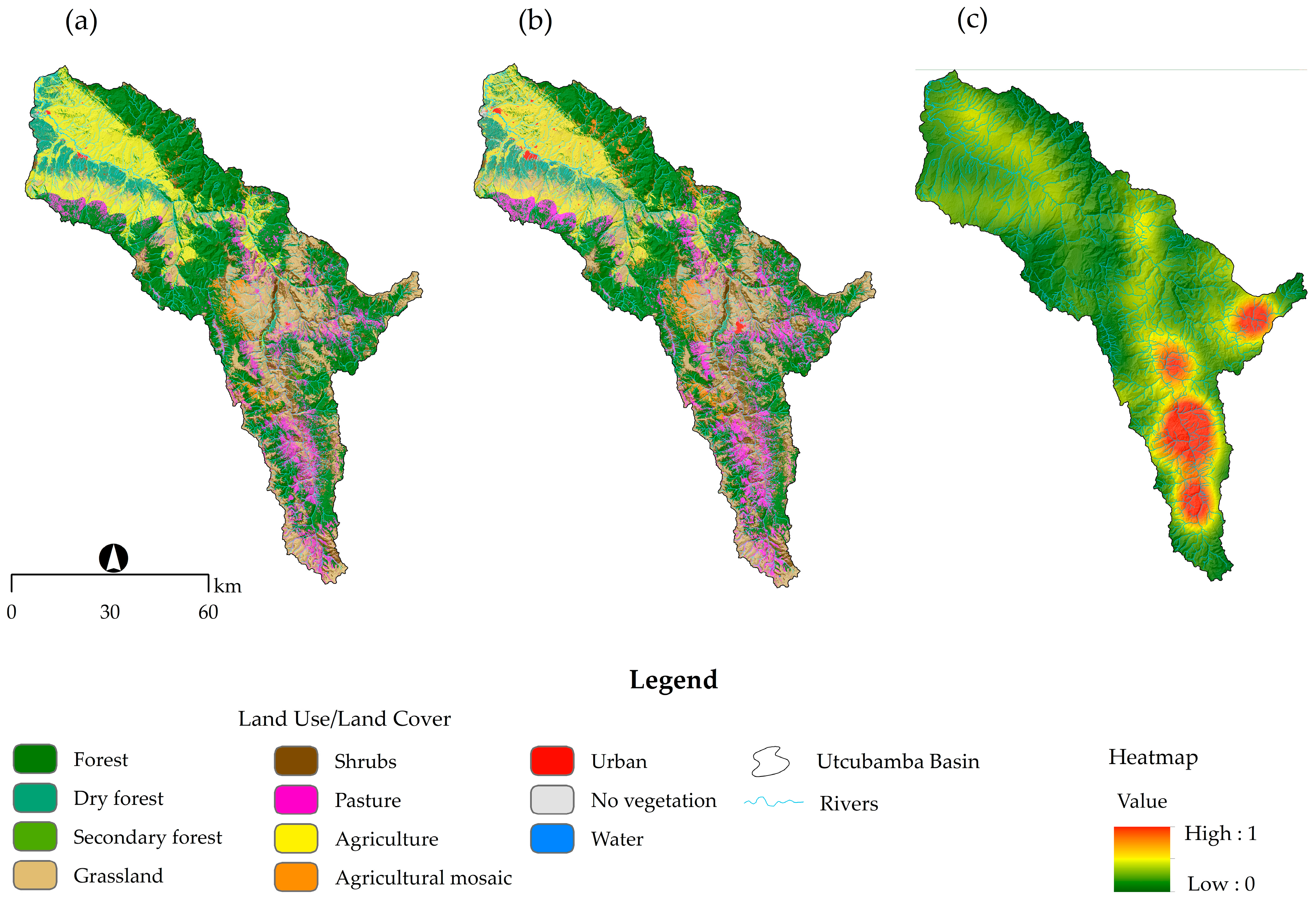
3.1. Land Use and Land Cover
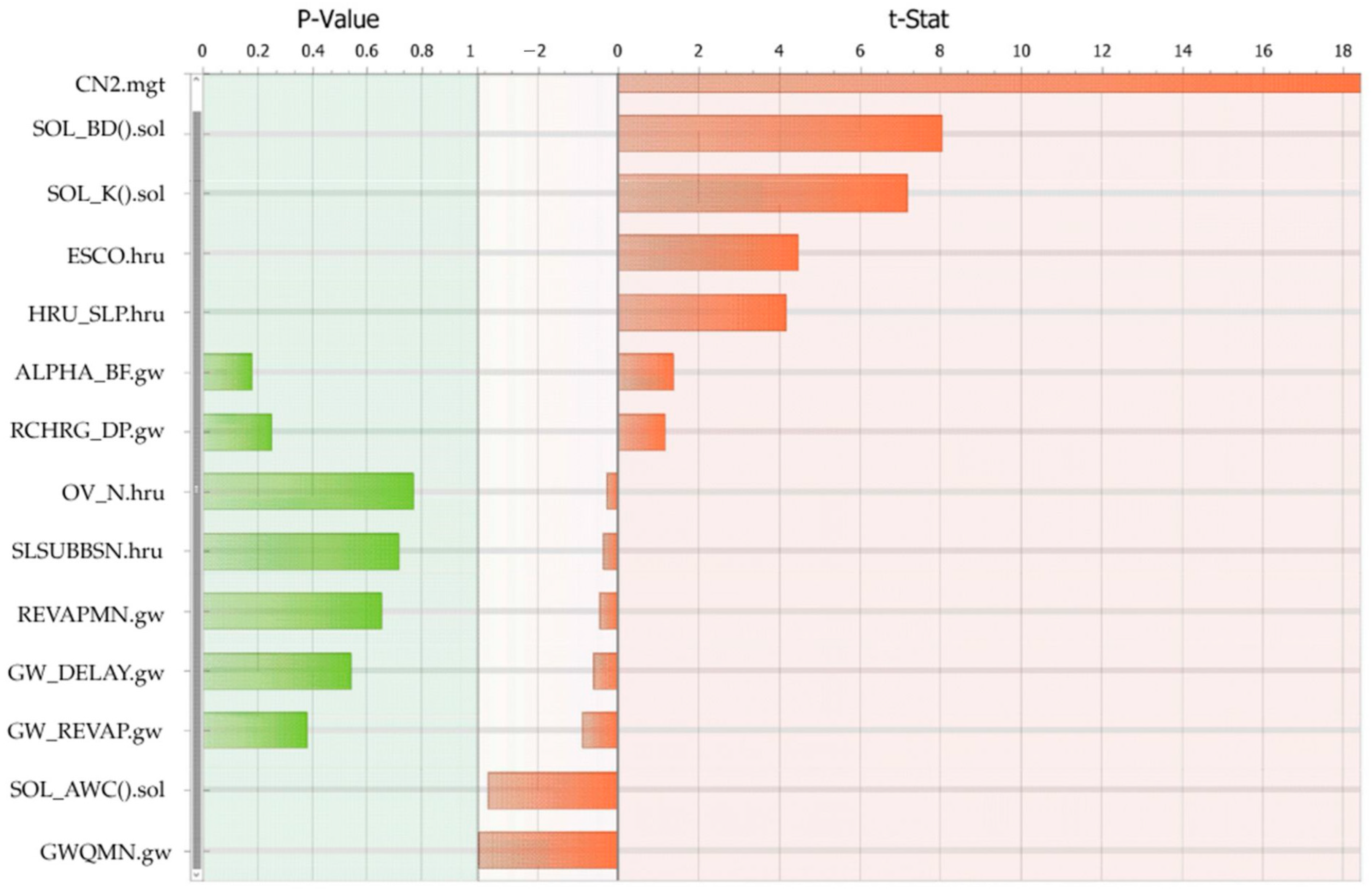
3.2. SWAT Model Sensitivity, Calibration y Validation
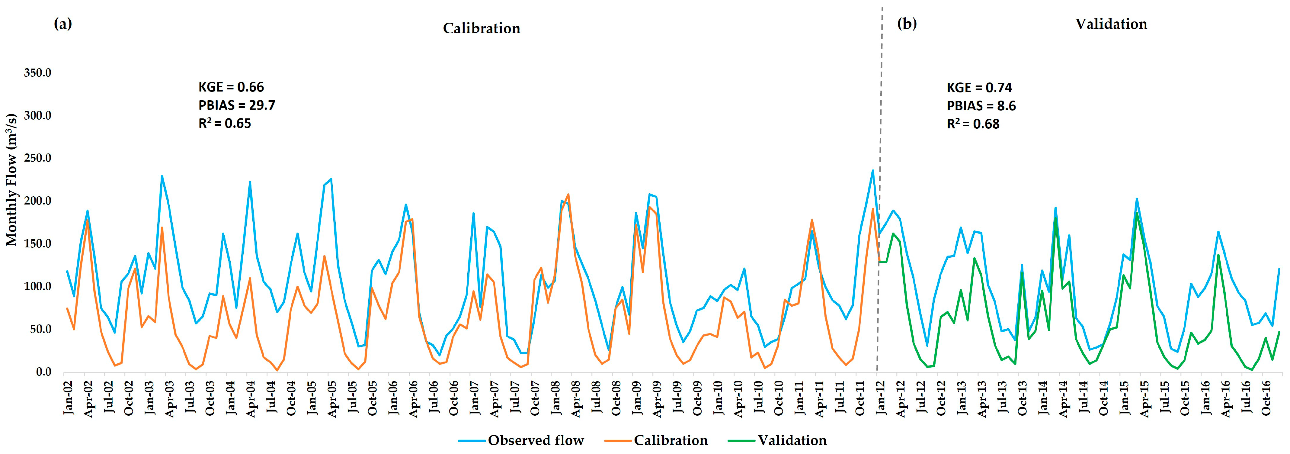
3.3. Hydrological Model Performance
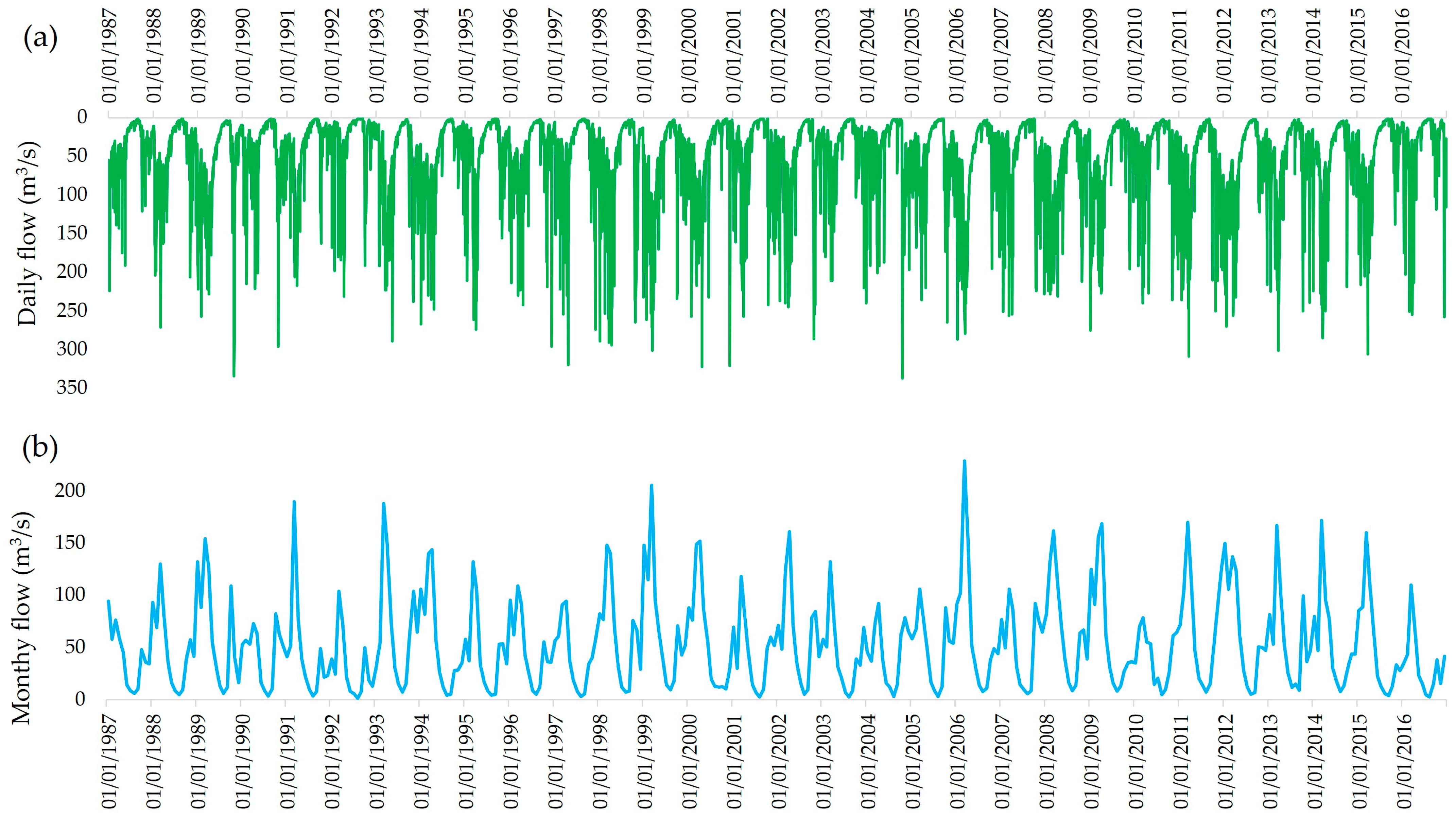
3.4. Historical Flow Dynamics in the Utcubamba Basin
3.5. Projected Hydrological Response Under Climate Scenary’s SSP2–4.5 and SSP5–8.5
3.6. Alterations in the Water Balance Under Future Climate Scenarios
3.7. Water Balance and Land Cover Change in the Utcubamba Watershed
4. Discussion
5. Conclusions
Author Contributions
Funding
Data Availability Statement
Acknowledgments
Conflicts of Interest
Correction Statement
References
- Shemer, H.; Wald, S.; Semiat, R. Challenges and Solutions for Global Water Scarcity. Membranes 2023, 13, 612. [Google Scholar] [CrossRef]
- Chen, Y.; Takeuchi, K.; Xu, C.; Chen, Y.; Xu, Z. Regional Climate Change and Its Effects on River Runoff in the Tarim Basin, China. Hydrol. Process. 2006, 20, 2207–2216. [Google Scholar] [CrossRef]
- Oki, T.; Kanae, S. Global Hydrological Cycles and World Water Resources. Science 2006, 313, 1068–1072. [Google Scholar] [CrossRef] [PubMed]
- Kaushal, S.S.; Gold, A.J.; Mayer, P.M. Land Use, Climate, and Water Resources-Global Stages of Interaction. Water 2017, 9, 815. [Google Scholar] [CrossRef] [PubMed]
- Elkouk, A.; Pokhrel, Y.; Satoh, Y.; Bouchaou, L. Implications of Changes in Climate and Human Development on 21st-Century Global Drought Risk. J. Environ. Manag. 2022, 317, 115378. [Google Scholar] [CrossRef]
- Meran, G.; Siehlow, M.; von Hirschhausen, C. Integrated Water Resource Management: Principles and Applications. In Springer Water; Springer Nature: Berlin, Germany, 2021; pp. 23–121. [Google Scholar]
- Katusiime, J.; Schütt, B. Integrated Water Resources Management Approaches to Improve Water Resources Governance. Water 2020, 12, 3424. [Google Scholar] [CrossRef]
- Xue, S.; Guo, X.; He, Y.; Cai, H.; Li, J.; Zhu, L.; Ye, C. Effects of Future Climate and Land Use Changes on Runoff in Tropical Regions of China. Sci. Rep. 2024, 14, 30922. [Google Scholar] [CrossRef]
- Flotemersch, J.E.; Leibowitz, S.G.; Hill, R.A.; Stoddard, J.L.; Thoms, M.C.; Tharme, R.E. A Watershed Integrity Definition and Assessment Approach to Support Strategic Management of Watersheds. River Res. Appl. 2016, 32, 1654–1671. [Google Scholar] [CrossRef]
- Wu, Y.; Zhang, H.; Lan, T.; Wei, X.; Shao, S.; Zhang, J.; Ding, H. Attribution of Runoff Variation to Climate and Human-Driven Changes in the Transition Zone between the Qinling Mountains and the Loess Plateau under Vegetation Greening. Hydrol. Res. 2022, 53, 733–753. [Google Scholar] [CrossRef]
- Khadka, D.; Babel, M.S.; Kamalamma, A.G. Assessing the Impact of Climate and Land-Use Changes on the Hydrologic Cycle Using the SWAT Model in the Mun River Basin in Northeast Thailand. Water 2023, 15, 3672. [Google Scholar] [CrossRef]
- Wang, K.; Yue, D.; Zhang, H. Runoff Simulation of the Upstream Watershed of the Feiling Hydrological Station in the Qinhe River Based on the SWAT Model. Water 2024, 16, 1044. [Google Scholar] [CrossRef]
- Badora, D.; Wawer, R.; Nieróbca, A.; Król-Badziak, A.; Kozyra, J.; Jurga, B.; Nowocień, E. Simulating the Effects of Agricultural Adaptation Practices onto the Soil Water Content in Future Climate Using SWAT Model on Upland Bystra River Catchment. Water 2022, 14, 2288. [Google Scholar] [CrossRef]
- Gupta, A.; Himanshu, S.K.; Gupta, S.; Singh, R. Evaluation of the SWAT Model for Analysing the Water Balance Components for the Upper Sabarmati Basin. In Lecture Notes in Civil Engineering; Springer: Berlin/Heidelberg, Germany, 2020; Volume 39, pp. 141–151. [Google Scholar]
- Valencia, S.; Villegas, J.C.; Hoyos, N.; Duque-Villegas, M.; Salazar, J.F. Streamflow Response to Land Use/Land Cover Change in the Tropical Andes Using Multiple SWAT Model Variants. J. Hydrol. Reg. Stud. 2024, 54, 101888. [Google Scholar] [CrossRef]
- Huang, X.; Qiu, L. Impacts of Climate Change and Land Use/Cover Change on Runoff in the Huangfuchuan River Basin. Land 2024, 13, 2048. [Google Scholar] [CrossRef]
- Aznarez, C.; Jimeno-Sáez, P.; López-Ballesteros, A.; Pacheco, J.P.; Senent-Aparicio, J. Analysing the Impact of Climate Change on Hydrological Ecosystem Services in Laguna Del Sauce (Uruguay) Using the Swat Model and Remote Sensing Data. Remote Sens. 2021, 13, 2014. [Google Scholar] [CrossRef]
- Valdivia, A.M.; Díaz, D.S. Impacto Del Cambio Climático En La Hidrología de Regiones Criohidrológicas: Una Revisión Sistemática. J. Sci. Metrics Eval. 2023, 1, 12–25. [Google Scholar] [CrossRef]
- Briceño, N.B.R.; Castillo, E.B.; Quintana, J.L.M.; Cruz, S.M.O.; López, R.S. Deforestation in the Peruvian Amazon: Indexes of Land Cover/Land Use (LC/LU) Changes Based on GIS. Bol. Asoc. Geogr. Esp. 2019, 81, 2538a. [Google Scholar] [CrossRef]
- Liu, Y.; Su, Y.; Wang, L.; Zhao, Y. Simulation and Evaluation of Runoff in Tributary of Weihe River Basin in Western China. Water 2024, 16, 221. [Google Scholar] [CrossRef]
- Colín-García, G.; Palacios-Vélez, E.; López-Pérez, A.; Bolaños-González, M.A.; Flores-Magdaleno, H.; Ascencio-Hernández, R.; Canales-Islas, E.I. Evaluation of the Impact of Climate Change on the Water Balance of the Mixteco River Basin with the SWAT Model. Hydrology 2024, 11, 45. [Google Scholar] [CrossRef]
- Masood, M.U.; Khan, N.M.; Haider, S.; Anjum, M.N.; Chen, X.; Gulakhmadov, A.; Iqbal, M.; Ali, Z.; Liu, T. Appraisal of Land Cover and Climate Change Impacts on Water Resources: A Case Study of Mohmand Dam Catchment, Pakistan. Water 2023, 15, 1313. [Google Scholar] [CrossRef]
- Ferraz, L.L.; de Sousa, L.F.; de Jesus, R.M.; Costa, K.A.; Santos, C.A.S.; Rocha, F.A. Climate and Land Use Changes Impacts on Streamflow in the Brazilian Cerrado Basin. Ecohydrol. Hydrobiol. 2024, 25, 357–366. [Google Scholar] [CrossRef]
- Barreto-Martin, C.; Sierra-Parada, R.; Calderón-Rivera, D.; Jaramillo-Londono, A.; Mesa-Fernández, D. Spatio-Temporal Analysis of the Hydrological Response to Land Cover Changes in the Sub-Basin of the Chicú River, Colombia. Heliyon 2021, 7, e07358. [Google Scholar] [CrossRef] [PubMed]
- Mera-Parra, C.; Oñate-Valdivieso, F.; Massa-Sánchez, P.; Ochoa-Cueva, P. Establishment of the Baseline for the Iwrm in the Ecuadorian Andean Basins: Land Use Change, Water Recharge, Meteorological Forecast and Hydrological Modeling. Land 2021, 10, 513. [Google Scholar] [CrossRef]
- Pachac-Huerta, Y.; Lavado-Casimiro, W.; Zapana, M.; Peña, R. Understanding Spatio-Temporal Hydrological Dynamics Using SWAT: A Case Study in the Pativilca Basin. Hydrology 2024, 11, 165. [Google Scholar] [CrossRef]
- Paiva, K.; Rau, P.; Montesinos, C.; Lavado-Casimiro, W.; Bourrel, L.; Frappart, F. Hydrological Response Assessment of Land Cover Change in a Peruvian Amazonian Basin Impacted by Deforestation Using the SWAT Model. Remote Sens. 2023, 15, 5774. [Google Scholar] [CrossRef]
- Cotrina Sánchez, A.; Salazar, A.; Oviedo, C.; Bandopadhyay, S.; Mondaca, P.; Valentini, R.; Rojas Briceño, N.B.; Torres Guzmán, C.; Oliva, M.; Guzman, B.K.; et al. Integrated Cloud Computing and Cost Effective Modelling to Delineate the Ecological Corridors for Spectacled Bears (Tremarctos Ornatus) in the Rural Territories of the Peruvian Amazon. Glob. Ecol. Conserv. 2022, 36, e02126. [Google Scholar] [CrossRef]
- Yunis, C.R.C.; López, R.S.; Cruz, S.M.O.; Castillo, E.B.; López, J.O.S.; Trigoso, D.I.; Briceño, N.B.R. Land Suitability for Sustainable Aquaculture of Rainbow Trout (Oncorhynchus Mykiss) in Molinopampa (Peru) Based on RS, GIS, and AHP. ISPRS Int. J. Geo-Inf. 2020, 9, 28. [Google Scholar] [CrossRef]
- Medina Medina, A.J.; Salas López, R.; Zabaleta Santisteban, J.A.; Tuesta Trauco, K.M.; Turpo Cayo, E.Y.; Huaman Haro, N.; Oliva Cruz, M.; Gómez Fernández, D. An Analysis of the Rice-Cultivation Dynamics in the Lower Utcubamba River Basin Using SAR and Optical Imagery in Google Earth Engine (GEE). Agronomy 2024, 14, 557. [Google Scholar] [CrossRef]
- Gómez-Fernández, D.; López, R.S.; Zabaleta-Santisteban, J.A.; Medina-Medina, A.J.; Goñas, M.; Silva-López, J.O.; Oliva-Cruz, M.; Rojas-Briceño, N.B. Landsat Images and GIS Techniques as Key Tools for Historical Analysis of Landscape Change and Fragmentation. Ecol. Inform. 2024, 82, 102738. [Google Scholar] [CrossRef]
- United Nations Transformar Nuestro Mundo: La Agenda 2030 para el Desarrollo Sostenible|Departamento de Asuntos Económicos y Sociales. Available online: https://sdgs.un.org/2030agenda (accessed on 27 May 2025).
- Castro, W.F. Geomorfología. In Estudios Temáticos para la Zoonificación Ecológica y Económica del Departamento de Amazonas; IIAP: Amazonas, Peru, 2014; p. 55. [Google Scholar]
- Huaman, N.; Lopezhaya Mendoza, J.B.; Medina Medina, A.J.; Zabaleta Santisteban, J.A.; Tineo Flores, D.; Juarez-Contreras, L.; Goñas, M.; Oliva-Cruz, M. Agronomic and Economic Evaluation of Tree Species in Agroforestry Systems with Cocoa (Theobroma cacao L.) in Amazonas. Preprints 2024. [Google Scholar] [CrossRef]
- Orrillo, G. Ecoturismo Como Estrategia de Desarrollo Sostenible del Área de Conservación Privada Hierva Buena—Allpayacu: Provincia de Bongará, Amazonas, 2021; IIAP: Amazonas, Peru, 2022; Available online: https://hdl.handle.net/20.500.14077/2717 (accessed on 10 May 2025).
- Instituto Nacional de Estadística e Informática (INEI) Censos Nacionales 2017: XII Población, VII Vivienda y III Comunidades IndÍgenas. Available online: https://censos2017.inei.gob.pe/redatam/ (accessed on 25 May 2025).
- Goñas, M.; Rojas-Briceño, N.B.; Gómez Fernández, D.; Iliquín Trigoso, D.; Atalaya Marin, N.; Bravo, V.C.; Díaz-Valderrama, J.R.; Maicelo-Quintana, J.L.; Oliva-Cruz, M. Economic Profitability of Carbon Sequestration of Fine-Aroma Cacao Agroforestry Systems in Amazonas, Peru. Forests 2024, 15, 500. [Google Scholar] [CrossRef]
- SENAMHI Datos Hidrometereologicos. Available online: https://www.senamhi.gob.pe/site/descarga-datos/ (accessed on 10 July 2024).
- Gorelick, N.; Hancher, M.; Dixon, M.; Ilyushchenko, S.; Thau, D.; Moore, R. Google Earth Engine: Planetary-Scale Geospatial Analysis for Everyone. Remote Sens. Environ. 2017, 202, 18–27. [Google Scholar] [CrossRef]
- Barboza, E.; Turpo, E.Y.; Tariq, A.; Salas López, R.; Pizarro, S.; Zabaleta-Santisteban, J.A.; Medina-Medina, A.J.; Tuesta-Trauco, K.M.; Oliva-Cruz, M.; Vásquez, H.V. Spatial Distribution of Burned Areas from 1986 to 2023 Using Cloud Computing: A Case Study in Amazonas (Peru). Fire 2024, 7, 413. [Google Scholar] [CrossRef]
- Peñuelas, J.; Gamon, J.A.; Griffin, K.L.; Field, C.B. Assessing Community Type, Plant Biomass, Pigment Composition, and Photosynthetic Efficiency of Aquatic Vegetation from Spectral Reflectance. Remote Sens. Environ. 1993, 46, 110–118. [Google Scholar] [CrossRef]
- McFeeters, S.K. The Use of the Normalized Difference Water Index (NDWI) in the Delineation of Open Water Features. Int. J. Remote Sens. 1996, 17, 1425–1432. [Google Scholar] [CrossRef]
- Gitelson, A.A.; Gritz, Y.; Merzlyak, M.N. Relationships between Leaf Chlorophyll Content and Spectral Reflectance and Algorithms for Non-Destructive Chlorophyll Assessment in Higher Plant Leaves. J. Plant Physiol. 2003, 160, 271–282. [Google Scholar] [CrossRef]
- Huete, A.R. A Soil-Adjusted Vegetation Index (SAVI). Remote Sens. Environ. 1988, 25, 295–309. [Google Scholar] [CrossRef]
- Key, C.H.; Benson, N. The Normalized Burn Ratio (NBR): A Landsat TM Radiometric Measure of Burn Severity; USGS Northern Rocky Mountain Science Center. Available online: https://www.frames.gov/catalog/5860 (accessed on 6 June 2025).
- Watson, D.J. Comparative Physiological Studies on the Growth of Field Crops: I. Variation in Net Assimilation Rate and Leaf Area between Species and Varieties, and within and between Years. Ann. Bot. 1947, 11, 41–76. [Google Scholar] [CrossRef]
- Farr, T.G.; Rosen, P.A.; Caro, E.; Crippen, R.; Duren, R.; Hensley, S.; Kobrick, M.; Paller, M.; Rodriguez, E.; Roth, L.; et al. The Shuttle Radar Topography Mission. Rev. Geophys. 2007, 45, 2004. [Google Scholar] [CrossRef]
- Aguilar, R.; Zurita-Milla, R.; Izquierdo-Verdiguier, E.; de By, R.A. A Cloud-Based Multi-Temporal Ensemble Classifier to Map Smallholder Farming Systems. Remote Sens. 2018, 10, 729. [Google Scholar] [CrossRef]
- MINAM. Mapa Nacional de Cobertura Vegetal. Memoria Descriptiva; Dirección General de Evaluación, Valoración y Financiamiento del Patrimonio Natural: Lima, Perú, 2015. [Google Scholar]
- Breiman, L. Random Forests. Mach. Learn. 2001, 45, 5–32. [Google Scholar] [CrossRef]
- Nguyen, L.H.; Joshi, D.R.; Clay, D.E.; Henebry, G.M. Characterizing Land Cover/Land Use from Multiple Years of Landsat and MODIS Time Series: A Novel Approach Using Land Surface Phenology Modeling and Random Forest Classifier. Remote Sens. Environ. 2020, 238, 111017. [Google Scholar] [CrossRef]
- Talukdar, S.; Eibek, K.U.; Akhter, S.; Ziaul, S.; Towfiqul Islam, A.R.M.; Mallick, J. Modeling Fragmentation Probability of Land-Use and Land-Cover Using the Bagging, Random Forest and Random Subspace in the Teesta River Basin, Bangladesh. Ecol. Indic. 2021, 126, 107612. [Google Scholar] [CrossRef]
- Barboza, E.; Salazar, W.; Gálvez-Paucar, D.; Valqui-Valqui, L.; Saravia, D.; Gonzales, J.; Aldana, W.; Vásquez, H.V.; Arbizu, C.I. Cover and Land Use Changes in the Dry Forest of Tumbes (Peru) Using Sentinel-2 and Google Earth Engine Data. Environ. Sci. Proc. 2022, 22, 2. [Google Scholar] [CrossRef]
- Arizapana-Almonacid, M.A.; Pariona-Antonio, V.H.; Castañeda-Tinco, I.; Ascención Mendoza, J.C.; Gutiérrez Gómez, E.; Ramoni-Perazzi, P. Land Cover Changes and Comparison of Current Landscape Metrics in a Region of the Central Andes Affected by Population Migration. Ann. GIS 2024, 30, 105–120. [Google Scholar] [CrossRef]
- Thanh Noi, P.; Kappas, M. Comparison of Random Forest, k-Nearest Neighbor, and Support Vector Machine Classifiers for Land Cover Classification Using Sentinel-2 Imagery. Sensors 2017, 18, 18. [Google Scholar] [CrossRef] [PubMed]
- Cohen, J. A Coefficient of Agreement for Nominal Scales. Educ. Psychol. Meas. 1960, 20, 37–46. [Google Scholar] [CrossRef]
- Heydari, S.S.; Mountrakis, G. Effect of Classifier Selection, Reference Sample Size, Reference Class Distribution and Scene Heterogeneity in per-Pixel Classification Accuracy Using 26 Landsat Sites. Remote Sens. Environ. 2018, 204, 648–658. [Google Scholar] [CrossRef]
- MINAM. Nota Técnica No. 1. Programa Nacional de Conservación de Bosques Mapas Kernel Como Indicador de la Concentración de la Pérdida de Bosques Húmedos Amazónicos del Perú; Ministerio del Ambiente (Perú): Lima, Peru, 2014; pp. 1–14. [Google Scholar]
- Villamizar, S.R.; Pineda, S.M.; Carrillo, G.A. The Effects of Land Use and Climate Change on the Water Yield of a Watershed in Colombia. Water 2019, 11, 285. [Google Scholar] [CrossRef]
- ISRIC SOIL GRIDS. Available online: https://www.isric.org/explore/soilgrids (accessed on 8 July 2024).
- PISCO SENAMHI HSR PISCO. Available online: https://iridl.ldeo.columbia.edu/SOURCES/.SENAMHI/.HSR/.PISCO/index.html?Set-Language=es (accessed on 20 February 2024).
- Asurza-Véliz, F.A.; Lavado-Casimiro, W.S. Regional Parameter Estimation of the SWAT Model: Methodology and Application to River Basins in the Peruvian Pacific Drainage. Water 2020, 12, 3198. [Google Scholar] [CrossRef]
- ANA. Observatorio Nacional de Recursos Hídricos. Autoridad Nacional del Agua (Perú), Lima, Perú. Available online: https://snirh.ana.gob.pe/onrh/ (accessed on 10 July 2024).
- Murillo, P.; Fabricio, R. Impacto Del Uso de Suelo y Cambio Climático En El Caudal y Generación de Sedimentos En La Cuenca Puyango-Tumbes. Ph.D. Thesis, Universidad Nacional Agraria La Molina, Lima, Peru, 2024. [Google Scholar]
- NCCS. Proyecciones Diarias Reducidas Globales de NASA Earth Exchange (NEX-GDDP-CMIP6). Available online: https://www.nccs.nasa.gov/services/data-collections/land-based-products/nex-gddp-cmip6 (accessed on 12 March 2025).
- Goyal, M.K.; Panchariya, V.K.; Sharma, A.; Singh, V. Comparative Assessment of SWAT Model Performance in Two Distinct Catchments under Various DEM Scenarios of Varying Resolution, Sources and Resampling Methods. Water Resour. Manag. 2018, 32, 805–825. [Google Scholar] [CrossRef]
- Tan, M.L.; Ficklin, D.L.; Dixon, B.; Ibrahim, A.L.; Yusop, Z.; Chaplot, V. Impacts of DEM Resolution, Source, and Resampling Technique on SWAT-Simulated Streamflow. Appl. Geogr. 2015, 63, 357–368. [Google Scholar] [CrossRef]
- Rufino, P.R.; Gücker, B.; Faramarzi, M.; Boëchat, I.G.; Cardozo, F.d.S.; Santos, P.R.; Zanin, G.D.; Mataveli, G.; Pereira, G. Evaluation of the SWAT Model for the Simulation of Flow and Water Balance Based on Orbital Data in a Poorly Monitored Basin in the Brazilian Amazon. Geographies 2022, 3, 1–18. [Google Scholar] [CrossRef]
- Arnold, J.G.; Srinivasan, R.; Muttiah, R.S.; Williams, J.R. LARGE AREA HYDROLOGIC MODELING AND ASSESSMENT PART I: MODEL DEVELOPMENT1. JAWRA J. Am. Water Resour. Assoc. 1998, 34, 73–89. [Google Scholar] [CrossRef]
- Neitsch, J.; Arnold, J.W. Soil and Water Assessment Tool Theoretical Documentation; Texas Water Resources Institute: College Station, TX, USA, 2005; Available online: https://swat.tamu.edu/media/1292/swat2005theory.pdf (accessed on 4 June 2025).
- Dile, Y.T.; Daggupati, P.; George, C.; Srinivasan, R.; Arnold, J. Introducing a New Open Source GIS User Interface for the SWAT Model. Environ. Model. Softw. 2016, 85, 129–138. [Google Scholar] [CrossRef]
- Sharma, A.; Patel, P.L.; Sharma, P.J. Influence of Climate and Land-Use Changes on the Sensitivity of SWAT Model Parameters and Water Availability in a Semi-Arid River Basin. CATENA 2022, 215, 106298. [Google Scholar] [CrossRef]
- Huerta, A.; Aybar, C.; Imfeld, N.; Correa, K.; Felipe-Obando, O.; Rau, P.; Drenkhan, F.; Lavado-Casimiro, W. High-Resolution Grids of Daily Air Temperature for Peru—The New PISCOt v1.2 Dataset. Sci. Data 2023, 10, 847. [Google Scholar] [CrossRef] [PubMed]
- Anaba, L.A.; Banadda, N.; Kiggundu, N.; Wanyama, J.; Engel, B.; Moriasi, D.; Anaba, L.A.; Banadda, N.; Kiggundu, N.; Wanyama, J.; et al. Application of SWAT to Assess the Effects of Land Use Change in the Murchison Bay Catchment in Uganda. Comput. Water Energy Environ. Eng. 2016, 6, 24–40. [Google Scholar] [CrossRef]
- Teshome, F.T.; Bayabil, H.K.; Thakural, L.N.; Welidehanna, F.G.; Teshome, F.T.; Bayabil, H.K.; Thakural, L.N.; Welidehanna, F.G. Modeling Stream Flow Using SWAT Model in the Bina River Basin, India. J. Water Resour. Prot. 2020, 12, 203–222. [Google Scholar] [CrossRef]
- Ntegeka, V.; Willems, P. Trends and Multidecadal Oscillations in Rainfall Extremes, Based on a More than 100-Year Time Series of 10 Min Rainfall Intensities at Uccle, Belgium. Water Resour. Res. 2008, 44, W07402. [Google Scholar] [CrossRef]
- Montenejto, J. GitHub—Hydroenvironment/Statdownscaling: Statistical Dowscaling of Climate Data at Daily Scale Using Quantile Mapping (QPM) Technique. Available online: https://github.com/Hydroenvironment/Statdownscaling (accessed on 28 April 2025).
- Tabari, H.; Taye, M.T.; Onyutha, C.; Willems, P. Decadal Analysis of River Flow Extremes Using Quantile-Based Approaches. Water Resour. Manag. 2017, 31, 3371–3387. [Google Scholar] [CrossRef]
- Taye, M.T.; Willems, P. Identifying Sources of Temporal Variability in Hydrological Extremes of the Upper Blue Nile Basin. J. Hydrol. 2013, 499, 61–70. [Google Scholar] [CrossRef]
- Rivera, P.; Herrera, E.; Ochoa, W. Comparación de Series Mensuales de Precipitación y Temperaturas de Los Modelos CMIP6 Para Guatemala. Ciencia Tecnol. Y Salud 2022, 9, 132–149. [Google Scholar] [CrossRef]
- Belgiu, M.; Drăgu, L. Random Forest in Remote Sensing: A Review of Applications and Future Directions. ISPRS J. Photogramm. Remote Sens. 2016, 114, 24–31. [Google Scholar] [CrossRef]
- Pizarro, S.E.; Pricope, N.G.; Vargas-Machuca, D.; Huanca, O.; Ñaupari, J. Mapping Land Cover Types for Highland Andean Ecosystems in Peru Using Google Earth Engine. Remote Sens. 2022, 14, 1562. [Google Scholar] [CrossRef]
- Guzman-Castillo, W.; Arellanos-Carrion, E.S.; Chavez-Quintana, S.G. Determinación e Incidencia de La Disposicion a Pagar En Esquemas de Pagos Por Servicios Ambientales Hidricos: Estudio de Casos En Las Capitales de Las Provincias de Chachapoyas, Rodriguez de Mendoza y Utcubamba. Folia Amaz. 2012, 21, 141. [Google Scholar] [CrossRef]
- Corroto, F.; Gamarra, O.; Barboza, E. Evaluación Multivariante de La Calidad Del Agua En La Cuenca Del Utcubamba (Perú)—Multivariate Assessment of Water Quality in the Utcubamba Basin (Peru). Tecnol. Y Cienc. Del Agua 2018, 9, 33–57. [Google Scholar] [CrossRef]
- Curatola Fernández, G.F.; Makowski Giannoni, S.; Delgado Florián, E.; Rengifo, P.; Rascón, J.; Chichipe Vela, E.; Butrich, C.; Salas López, R.; Oliva-Cruz, M.; Scheske, C. Mapping High-Altitude Peatlands to Inform a Landscape Conservation Strategy in the Andes of Northern Peru. Environ. Conserv. 2023, 50, 212–219. [Google Scholar] [CrossRef]
- Anore, H.W.; Lohani, T.K.; Ayalew, A.T. Identification of Potential Hydropower Generation Sites Using Geospatial Techniques in the Megecha Watershed of Ethiopia. Heliyon 2025, 11, e42063. [Google Scholar] [CrossRef]
- Nazari-Sharabian, M.; Taheriyoun, M.; Karakouzian, M. Sensitivity Analysis of the DEM Resolution and Effective Parameters of Runoff Yield in the SWAT Model: A Case Study. J. Water Supply Res. Technol. 2020, 69, 39–54. [Google Scholar] [CrossRef]
- Yu, Z. SWAT Output Viewer User Manual, Version 0.1. Available online: https://swatviewer.com/wp-content/uploads/2020/05/swatoutputviewermanual_v0.1.pdf (accessed on 4 June 2025).
- Rodríguez-Morata, C.; Díaz, H.F.; Ballesteros-Canovas, J.A.; Rohrer, M.; Stoffel, M. The Anomalous 2017 Coastal El Niño Event in Peru. Clim. Dyn. 2019, 52, 5605–5622. [Google Scholar] [CrossRef]
- Newell, F.L.; Ausprey, I.J.; Robinson, S.K. Spatiotemporal Climate Variability in the Andes of Northern Peru: Evaluation of Gridded Datasets to Describe Cloud Forest Microclimate and Local Rainfall. Int. J. Climatol. 2022, 42, 5892–5915. [Google Scholar] [CrossRef]
- Santisteban, J.A.Z.; López, R.S.; Rojas-Briceño, N.B.; Fernández, D.G.; Medina Medina, A.J.; Tuesta Trauco, K.M.; Rivera Fernandez, A.S.; Crisóstomo, J.L.; Oliva-Cruz, M.; Silva-López, J.O. Optimizing Landfill Site Selection Using Fuzzy-AHP and GIS for Sustainable Urban Planning. Civ. Eng. J. 2024, 10, 1698–1719. [Google Scholar] [CrossRef]
- Briceño, N.B.R.; Castillo, E.B.; Torres, O.A.G.; Oliva, M.; Tafur, D.L.; Gurbillón, M.Á.B.; Corroto, F.; López, R.S.; Rascón, J. Morphometric Prioritization, Fluvial Classification, and Hydrogeomorphological Quality in High Andean Livestock Micro-Watersheds in Northern Peru. ISPRS Int. J. Geo-Inf. 2020, 9, 305. [Google Scholar] [CrossRef]
- Krishnaswamy, J.; Bonell, M.; Venkatesh, B.; Purandara, B.K.; Rakesh, K.N.; Lele, S.; Kiran, M.C.; Reddy, V.; Badiger, S.; Krishnaswamy, J.; et al. The Groundwater Recharge Response and Hydrologic Services of Tropical Humid Forest Ecosystems to Use and Reforestation: Support for the “Infiltration-Evapotranspiration Trade-off Hypothesis”. J. Hydrol. 2013, 498, 191–209. [Google Scholar] [CrossRef]
- Fries, A.; Silva, K.; Pucha-Cofrep, F.; Oñate-Valdivieso, F.; Ochoa-Cueva, P. Water Balance and Soil Moisture Deficit of Different Vegetation Units under Semiarid Conditions in the Andes of Southern Ecuador. Climate 2020, 8, 30. [Google Scholar] [CrossRef]
- François, M.; de Aguiar, T.R.; Mielke, M.S.; Rousseau, A.N.; Faria, D.; Mariano-Neto, E. Interactions Between Forest Cover and Watershed Hydrology: A Conceptual Meta-Analysis. Water 2024, 16, 3350. [Google Scholar] [CrossRef]
- Molina, A.; Govers, G.; Vanacker, V.; Poesen, J.; Zeelmaekers, E.; Cisneros, F. Runoff Generation in a Degraded Andean Ecosystem: Interaction of Vegetation Cover and Land Use. CATENA 2007, 71, 357–370. [Google Scholar] [CrossRef]
- Mendoza Chichipe, M.E.; Salas López, R.; Barboza Castillo, E. Análisis Multitemporal de La Deforestación Usando La Clasificación Basada En Objetos, Distrito de Leymebamba (Perú). INDES Rev. Investig. Desarro. Sustentable 2017, 3, 67. [Google Scholar] [CrossRef][Green Version]
- Vásquez, H.V.; Huamán Puscán, M.M.; Bobadilla, L.G.; Zagaceta, H.; Valqui, L.; Maicelo, J.L.; Silva-López, J.O. Evaluation of Pasture Degradation through Vegetation Indices of the Main Livestock Micro-Watersheds in the Amazon Region (NW Peru). Environ. Sustain. Indic. 2023, 20, 100315. [Google Scholar] [CrossRef]
| Input Data | Resolution | Source |
|---|---|---|
| Precipitation | 1′ (~1.85 km) | [63] |
| Temperature (min and max) | 1′ (~1.85 km) | [63] |
| Digital Elevation Model | 30 m | [49] |
| Soil grid | 250 m | [62] |
| LULC | 30 m | |
| Hydrometric | - | [40] |
| Future climate | 1′ (~1.85 km) | [66] |
| Performance Rating | KGE | PBIAS (%) | R2 |
|---|---|---|---|
| Very good | 0.75 ≤ KGE ≤ 1 | PBIAS ≤ 15 | R2 ≥ 0.7 |
| Good | 0.65 ≤ KGE ≤ 0.75 | 15 ≤ PBIAS ≤ 30 | 0.6 ≤ R2 ≤ 0.7 |
| Satisfactory | 0.5 ≤ KGE ≤ 0.65 | 30 ≤PBIAS ≤ 55 | 0.5 ≤ R2 ≤ 0.6 |
| Unsatisfactory | KGE ≤ 0.5 | PBIAS ≥ 55 | R2 ≤ 0.5 |
| LULC Classes | Year 1990 ha (%) | Year 2024 ha (%) | Difference 2024–1990 ha (%) |
|---|---|---|---|
| Forest | 271,449.90 (40.82) | 255,951.99 (38.49) | −15,497.91 (−2.33) |
| Dry Forest | 32,042.61 (4.82) | 30,091.41(4.53) | −1951.20 (−0.29) |
| Secondary Forest | 560.61 (0.08) | 563.85 (0.08) | 3.24 (0.00) |
| Grassland | 119,919.78 (18.03) | 113,788.26 (17.11) | −6131.52 (−0.92) |
| Shrubs | 56,752.74 (8.53) | 64,669.86 (9.72) | 7917.12 (1.19) |
| Pastures | 60,650.46 (9.12) | 73,185.03 (11.01) | 12,534.57 (1.88) |
| Agriculture | 108,018.54 (16.24) | 99,500.04 (14.96) | −8518.50 (−1.28) |
| Agricultural mosaic | 12,388.05 (1.86) | 19,349.82 (2.91) | 6961.77 (1.05) |
| Urban | 751.50 (0.11) | 3243.06 (0.49) | 2491.56 (0.37) |
| Bare soil | 1554.12 (0.23) | 3674.25 (0.55) | 2120.13 (0.32) |
| Water bodies | 900.72 (0.14) | 971.46 (0.15) | 70.74 (0.01) |
| Total | 664,989.03 (100) | 664,989.03 (100) | - |
| Description | Parameter | Calibrated Range | Validated Value |
|---|---|---|---|
| Curve Number | CN2.mgt | 0–4 | 0.21 |
| Baseflow and alpha factor (1/day) | ALPHA_BF.gw | 0.01–0.1 | 0.09 |
| Threshold of water depth in the shallow aquifer required for return flow (mm H2O) | GWQMN.gw | 1–5000 | 987.5 |
| Groundwater coefficient “revap” | GW_REVAP.gw | 0.01–0.1 | 0.012 |
| Shallow aquifer water level for aquifer recharge to occur (mm H2O) | REVAPMN.gw | 0–1500 | 873.7 |
| Groundwater return period (days) | GW_DELAY.gw | 30–1000 | 536.8 |
| Compensatory factor for soil evaporation | ESCO.hru | 0.01–1 | 0.93 |
| Deep recharge factor | RCHRG_DP.gw | 0–1 | 0.85 |
| Average slope of the HRU | HRU_SLP.hru | −0.5–0.5 | −0.08 |
| Soil roughness for surface runoff | OV_N.hru | −0.5–0.5 | 0.35 |
| Sub-basin slope | SLSUBBSN.hru | −0.5–0.5 | −0.38 |
| Bulk density of the soil | SOL_BD().sol | −0.6–0.6 | 0.35 |
| Saturated hydraulic conductivity (mm/h) | SOL_K().sol | −0.8–0.8 | −0.36 |
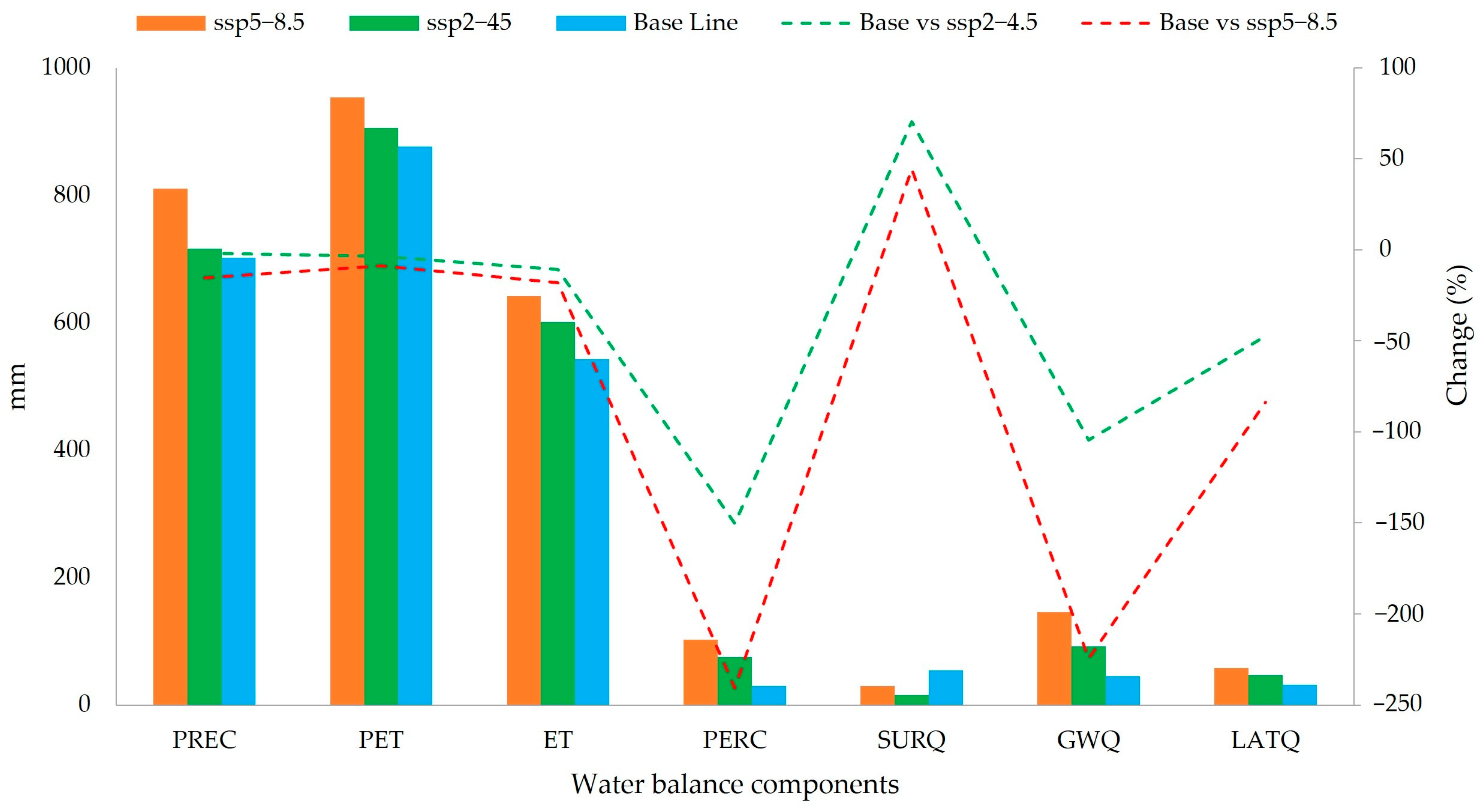
| Component | PREC (mm) | PET (mm) | ET (mm) | PERC (mm) | SURQ (mm) | GWQ (mm) | LATQ (mm) |
|---|---|---|---|---|---|---|---|
| ssp5_85 | 810.3 | 953.4 | 641.2 | 102.3 | 30.0 | 146.0 | 57.6 |
| ssp2_45 | 716.3 | 905.6 | 601.2 | 75.1 | 16.0 | 92.0 | 46.2 |
| Base Line | 702.0 | 876.0 | 542.6 | 30.0 | 54.0 | 45.0 | 31.3 |
| Base vs. ssp2_45 | −2.0 | −3.4 | −10.8 | −150.4 | 70.4 | −104.4 | −47.4 |
| Base vs. ssp5_85 | −15.4 | −8.8 | −18.2 | −240.9 | 44.4 | −224.4 | −83.8 |
Disclaimer/Publisher’s Note: The statements, opinions and data contained in all publications are solely those of the individual author(s) and contributor(s) and not of MDPI and/or the editor(s). MDPI and/or the editor(s) disclaim responsibility for any injury to people or property resulting from any ideas, methods, instructions or products referred to in the content. |
© 2025 by the authors. Licensee MDPI, Basel, Switzerland. This article is an open access article distributed under the terms and conditions of the Creative Commons Attribution (CC BY) license (https://creativecommons.org/licenses/by/4.0/).
Share and Cite
Rivera-Fernandez, A.S.; Cotrina-Sanchez, A.; Salas López, R.; Zabaleta-Santisteban, J.A.; Rios, N.; Medina-Medina, A.J.; Tuesta-Trauco, K.M.; Sánchez-Vega, J.A.; Silva-Melendez, T.B.; Oliva-Cruz, M.; et al. Spatiotemporal Land Cover Change and Future Hydrological Impacts Under Climate Scenarios in the Amazonian Andes: A Case Study of the Utcubamba River Basin. Land 2025, 14, 1234. https://doi.org/10.3390/land14061234
Rivera-Fernandez AS, Cotrina-Sanchez A, Salas López R, Zabaleta-Santisteban JA, Rios N, Medina-Medina AJ, Tuesta-Trauco KM, Sánchez-Vega JA, Silva-Melendez TB, Oliva-Cruz M, et al. Spatiotemporal Land Cover Change and Future Hydrological Impacts Under Climate Scenarios in the Amazonian Andes: A Case Study of the Utcubamba River Basin. Land. 2025; 14(6):1234. https://doi.org/10.3390/land14061234
Chicago/Turabian StyleRivera-Fernandez, Abner S., Alexander Cotrina-Sanchez, Rolando Salas López, Jhon A. Zabaleta-Santisteban, Ney Rios, Angel J. Medina-Medina, Katerin M. Tuesta-Trauco, José A. Sánchez-Vega, Teodoro B. Silva-Melendez, Manuel Oliva-Cruz, and et al. 2025. "Spatiotemporal Land Cover Change and Future Hydrological Impacts Under Climate Scenarios in the Amazonian Andes: A Case Study of the Utcubamba River Basin" Land 14, no. 6: 1234. https://doi.org/10.3390/land14061234
APA StyleRivera-Fernandez, A. S., Cotrina-Sanchez, A., Salas López, R., Zabaleta-Santisteban, J. A., Rios, N., Medina-Medina, A. J., Tuesta-Trauco, K. M., Sánchez-Vega, J. A., Silva-Melendez, T. B., Oliva-Cruz, M., Portocarrero, C., & Barboza, E. (2025). Spatiotemporal Land Cover Change and Future Hydrological Impacts Under Climate Scenarios in the Amazonian Andes: A Case Study of the Utcubamba River Basin. Land, 14(6), 1234. https://doi.org/10.3390/land14061234


