


Expanding Sustainable Land Governance: A Geospatial Framework for Incorporating Natural Parks into Urban Cadastres—Lessons from Darke de Mattos Park, Rio de Janeiro
 , , , , and
Abstract
1. Introduction
Objectives for This Study
- Providing a detailed current plan of Darke de Mattos Natural Park and its parcel;
- Proposing geospatial scenarios for its integration and expansion with the Atlantic forest remnant of Morro do Vigário, which take into account both social and environmental concerns while ensuring proper land governance;
- Incorporating constitutive elements of the multipurpose land cadastre (MLC), such as vector-based boundary delineation and descriptive boundary memorials, within the proposed scenarios.
2. Study Area
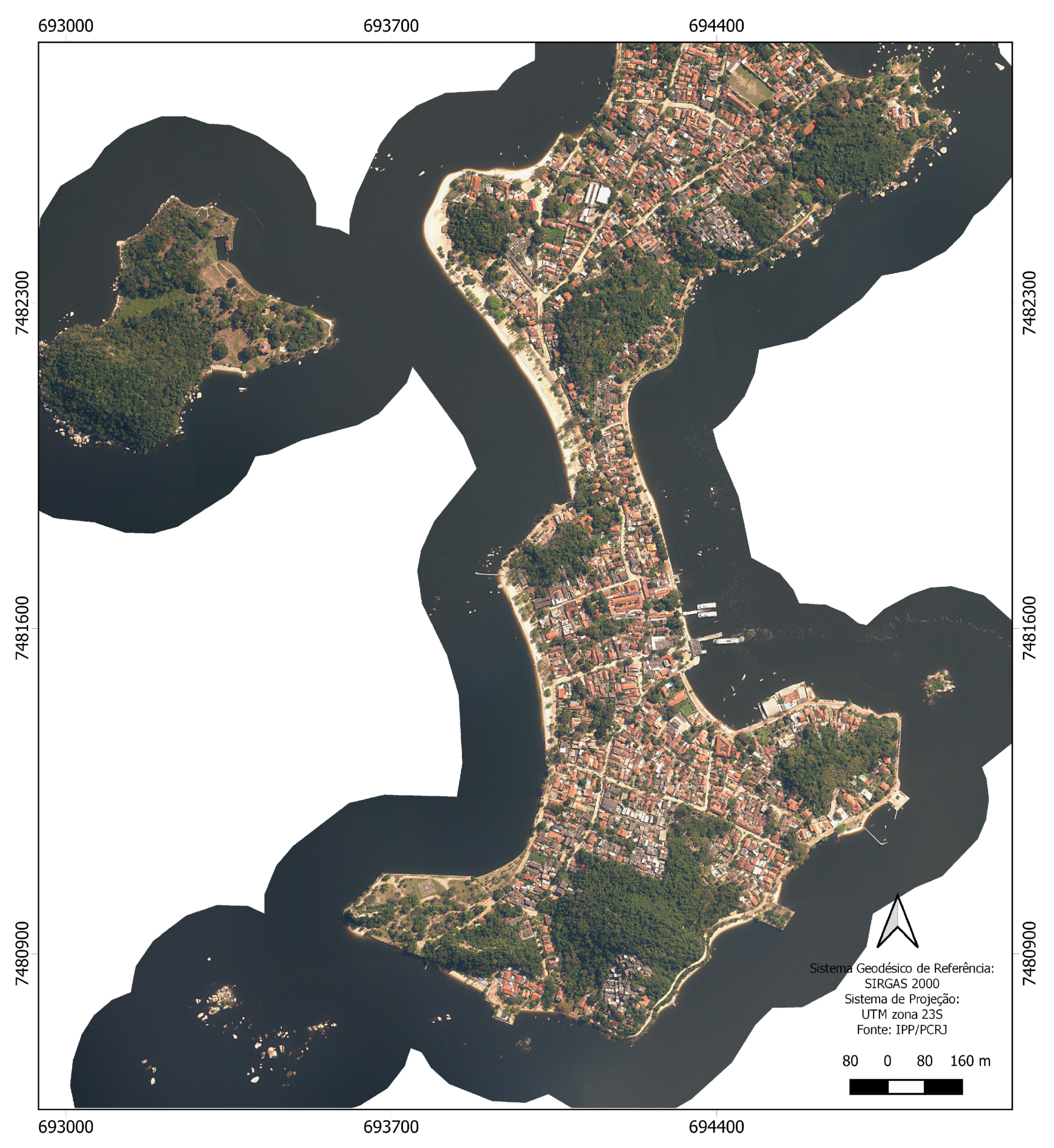
2.1. Paquetá Island
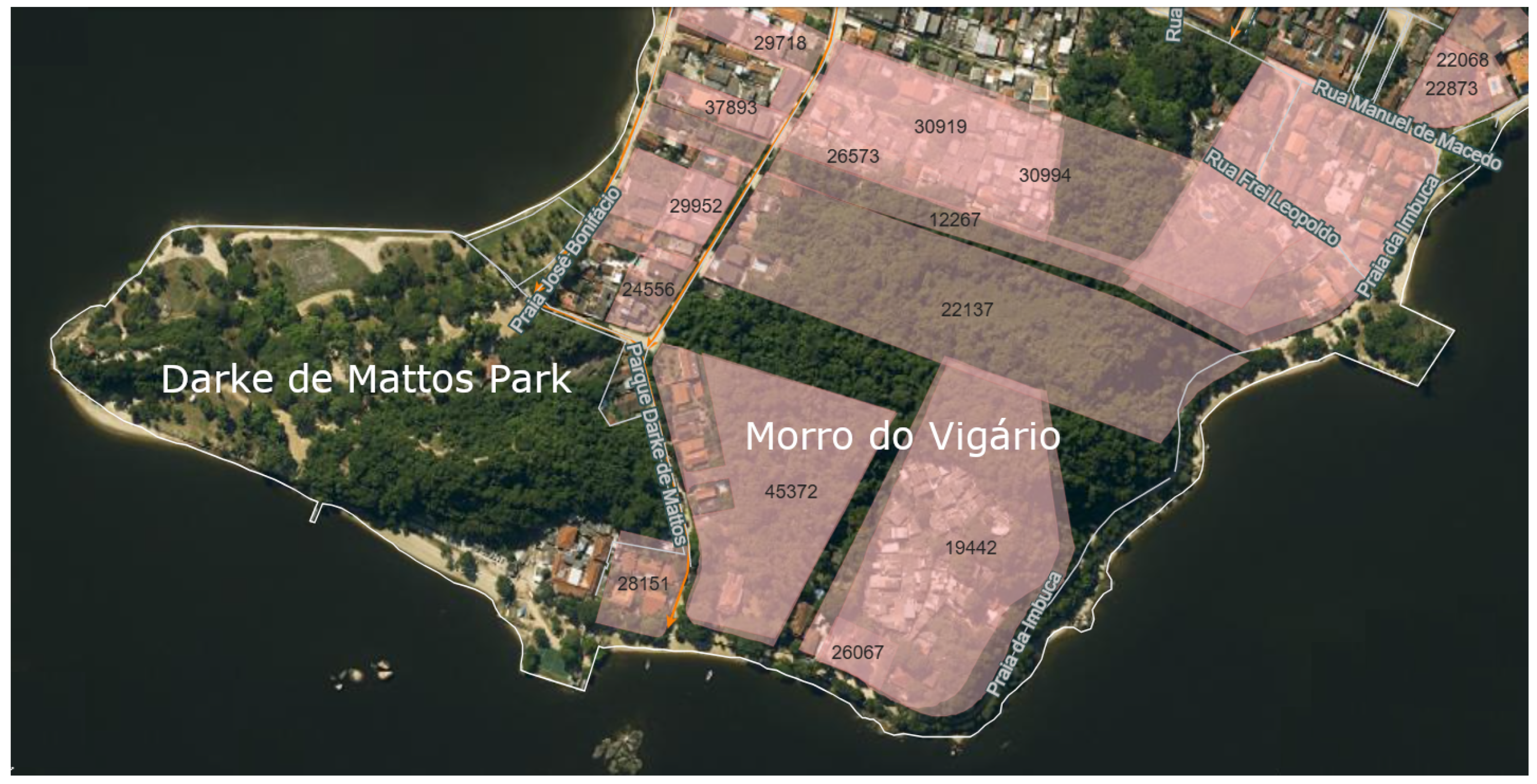
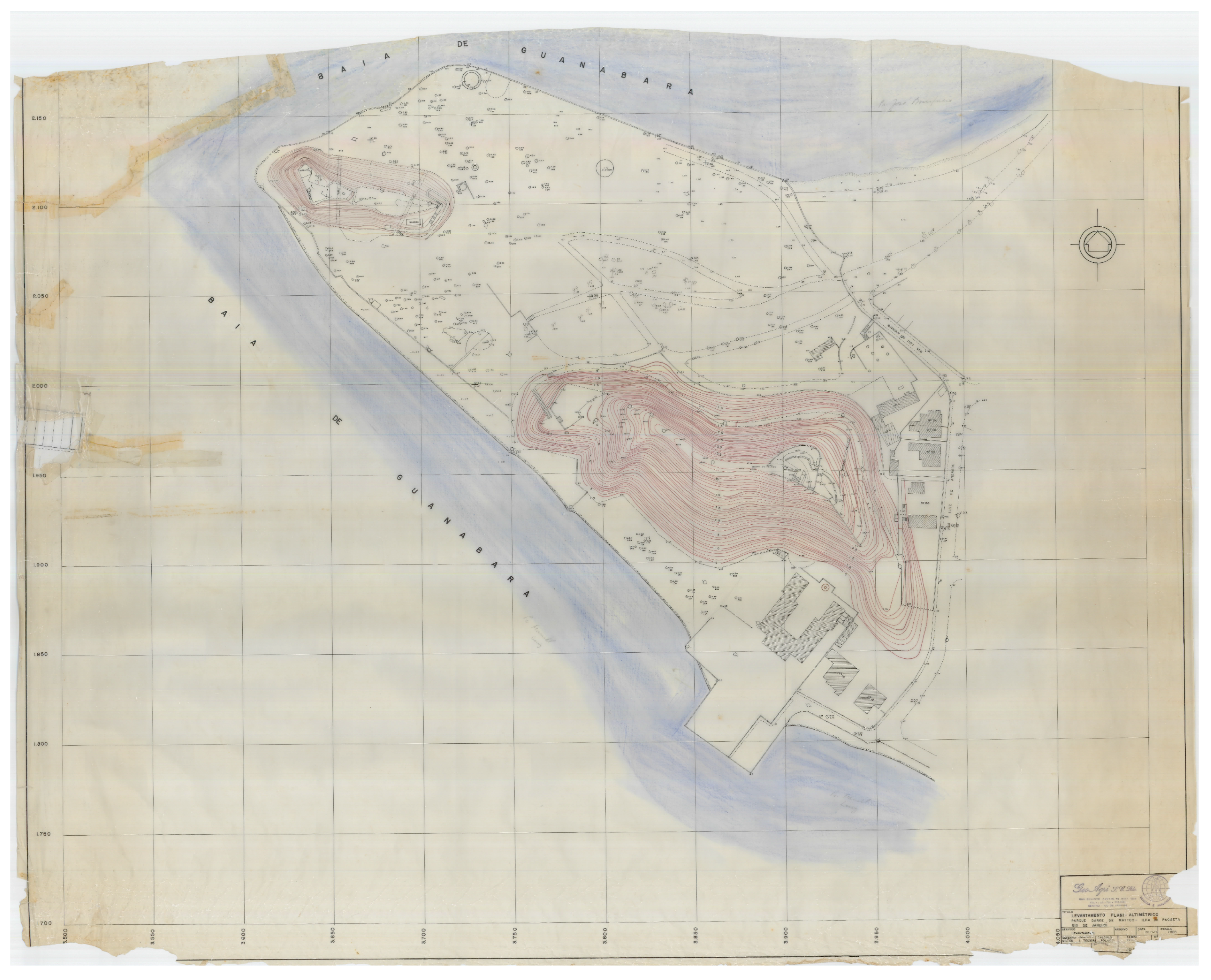
2.2. Darke de Mattos Natural Park
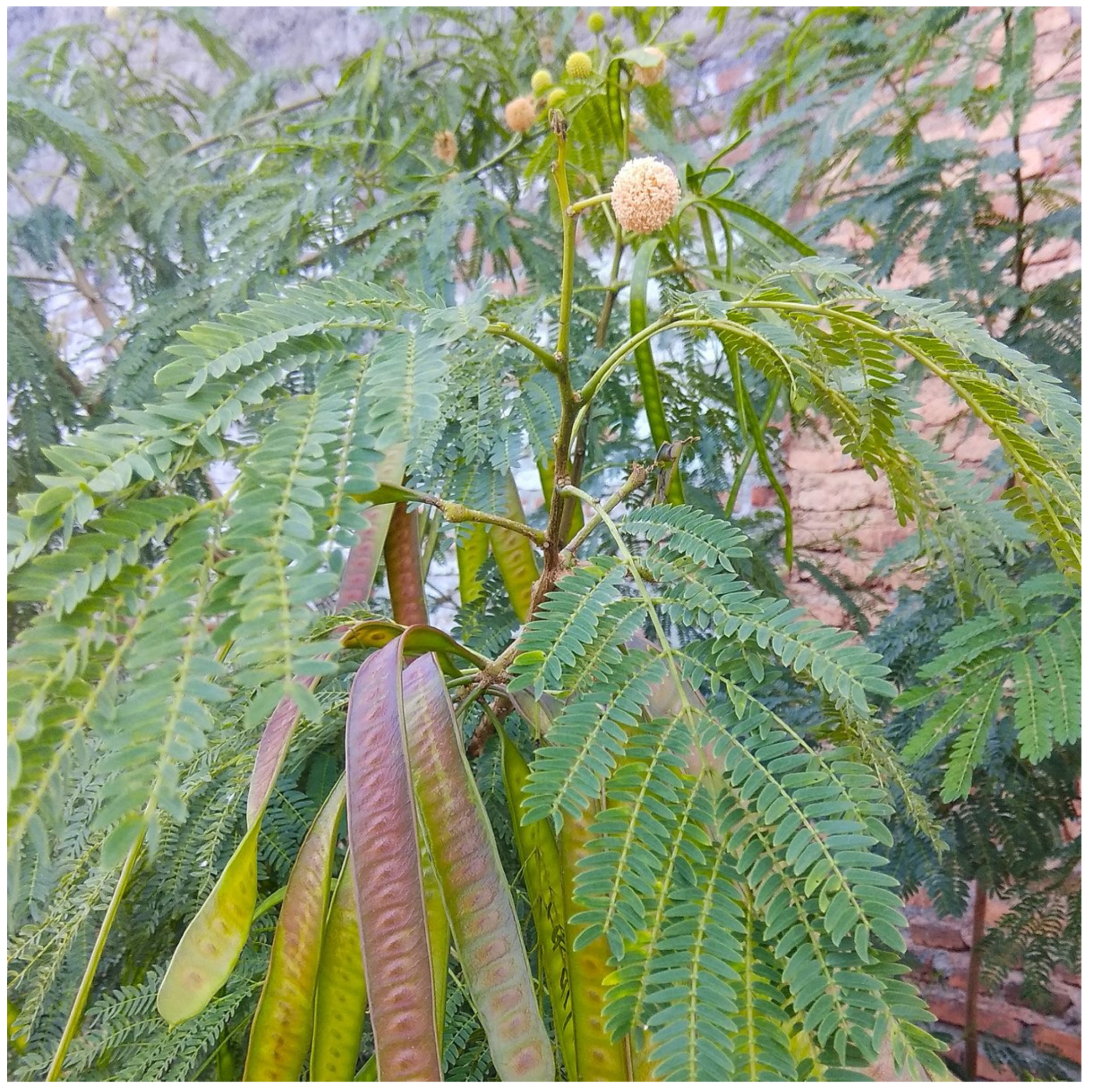
2.3. Biodiversity and Environmental Relevance of Paquetá
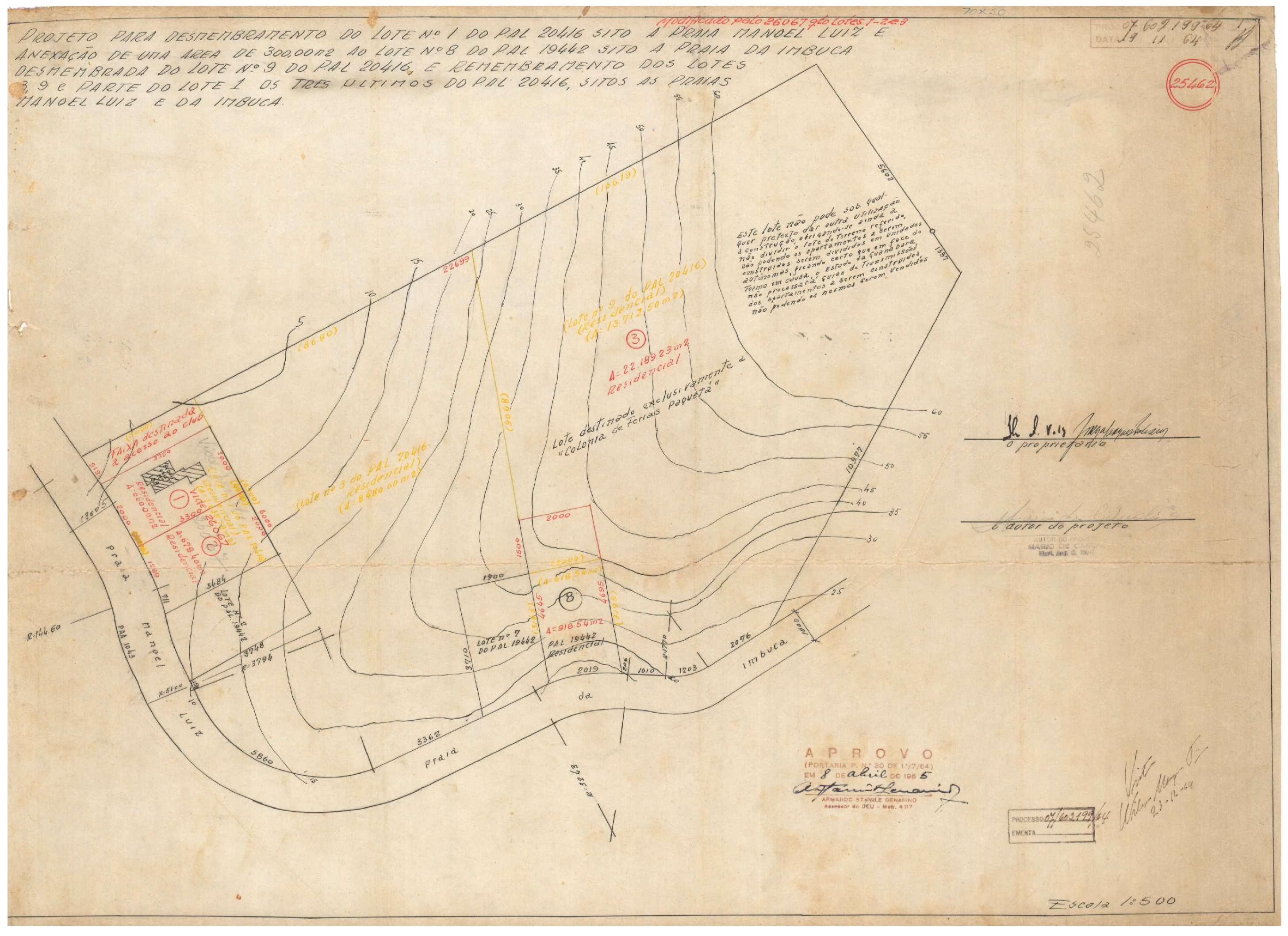
2.4. Cadastral Elements Pertaining to Darke de Mattos and Morro do Vigário
- Georeferenced boundary vertices within an established geodetic system;
- Unique identification codes;
- A consistent legal status, all of which are currently absent in the study area [60].
3. Materials and Methods
3.1. Equipment and Software
- Two GNSS receivers (base and rover) X91R, by CHC Nav (Shanghai, China), supporting carrier wave frequencies L1, L2, and L5 and the GPS, GLONASS, GALILEO, and BEIDOU constellations;
- A Phantom 4 RPA (remotely piloted aircraft), by DJI (Shenzhen, China) with RTK GNSS positioning, an accuracy of 1 cm + 1 ppm (horizontal) and 1.5 cm + 1 ppm (vertical), and 20 MP camera with a 1-inch CMOS sensor;
- An aluminum tripod with a circular bubble level;
- An aluminum bipod with a rod and a circular bubble level.
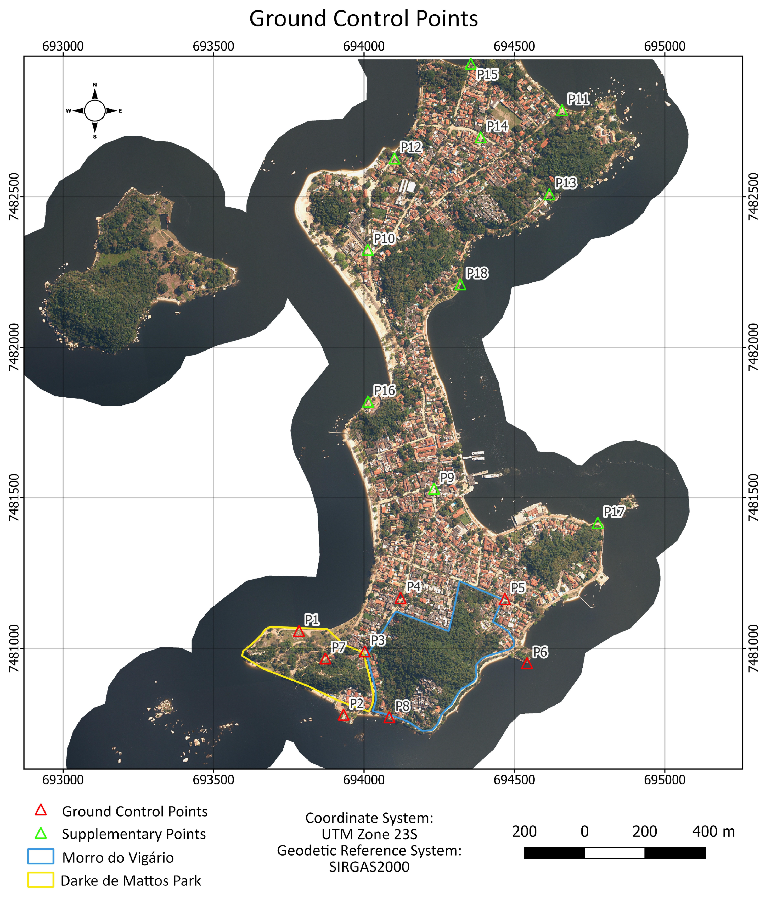
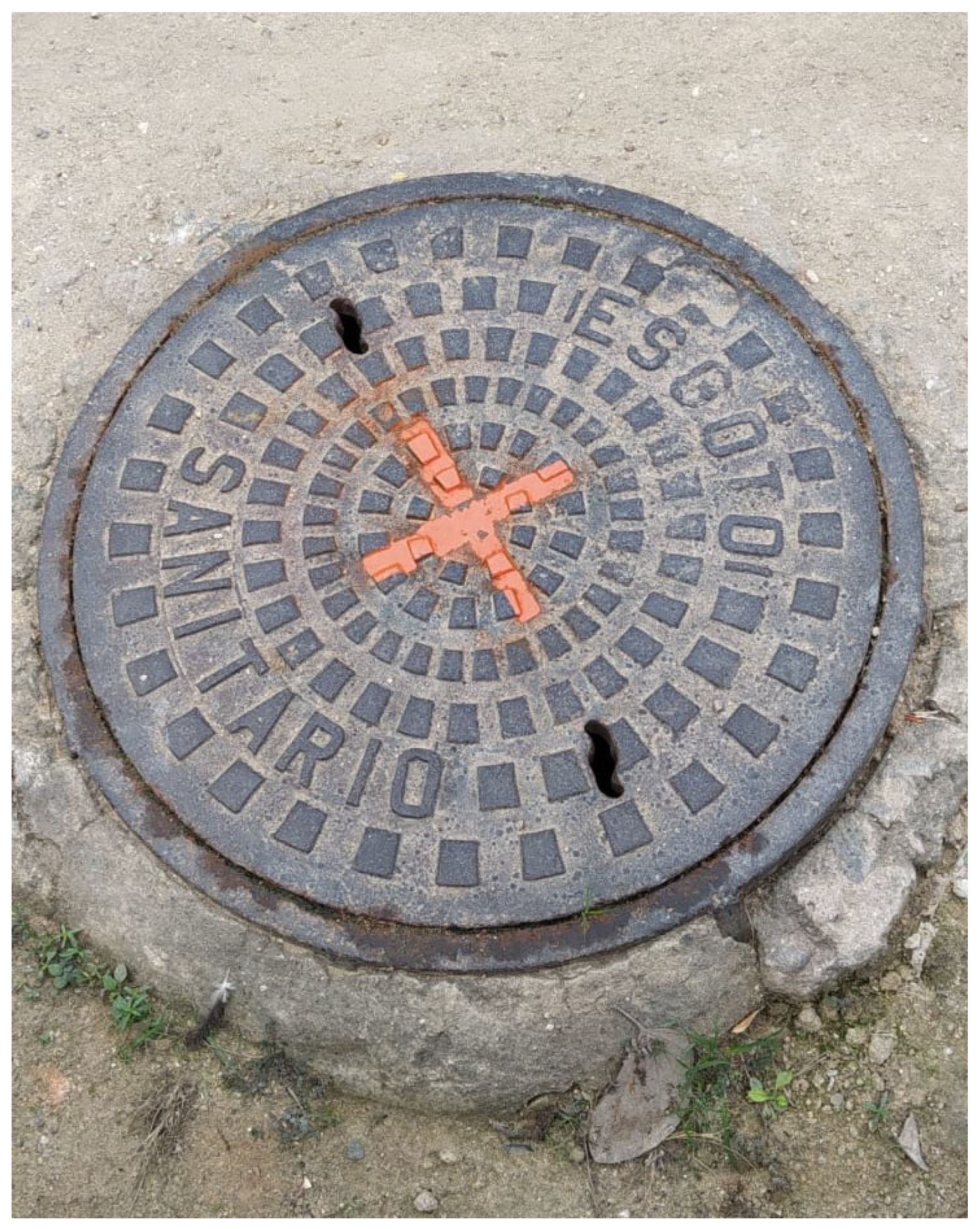
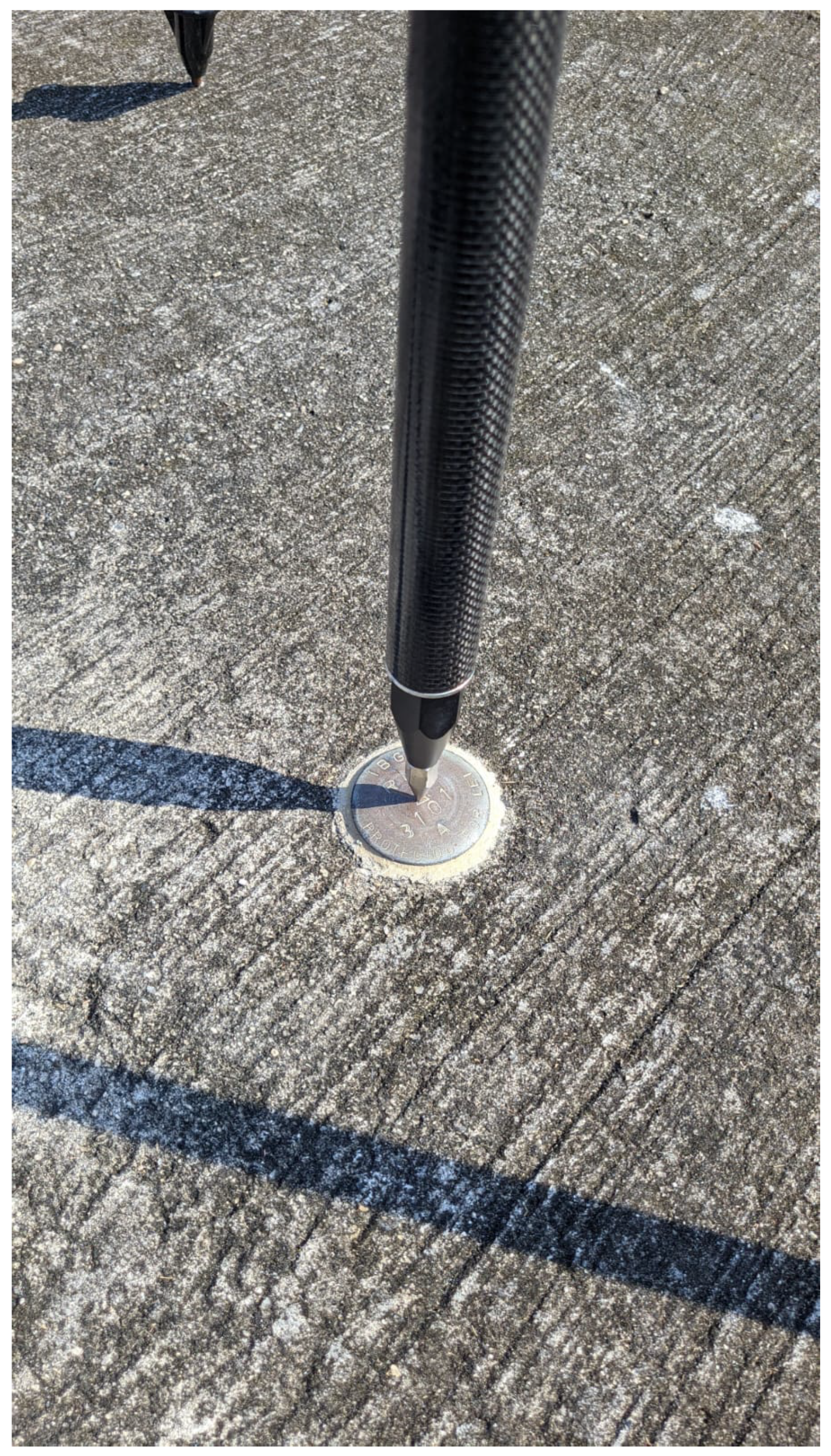
3.2. Ground Control Point Survey
3.3. Flight Planning and Photogrammetric Processing
- Root-mean-square errors from the photogrammetric bundle adjustment;
- The visual comparison of the orthomosaic with official base maps from Rio de Janeiro City Hall;
- The selection of known coordinate points and error analysis relative to their equivalents in the digital cartographic product (orthomosaic).
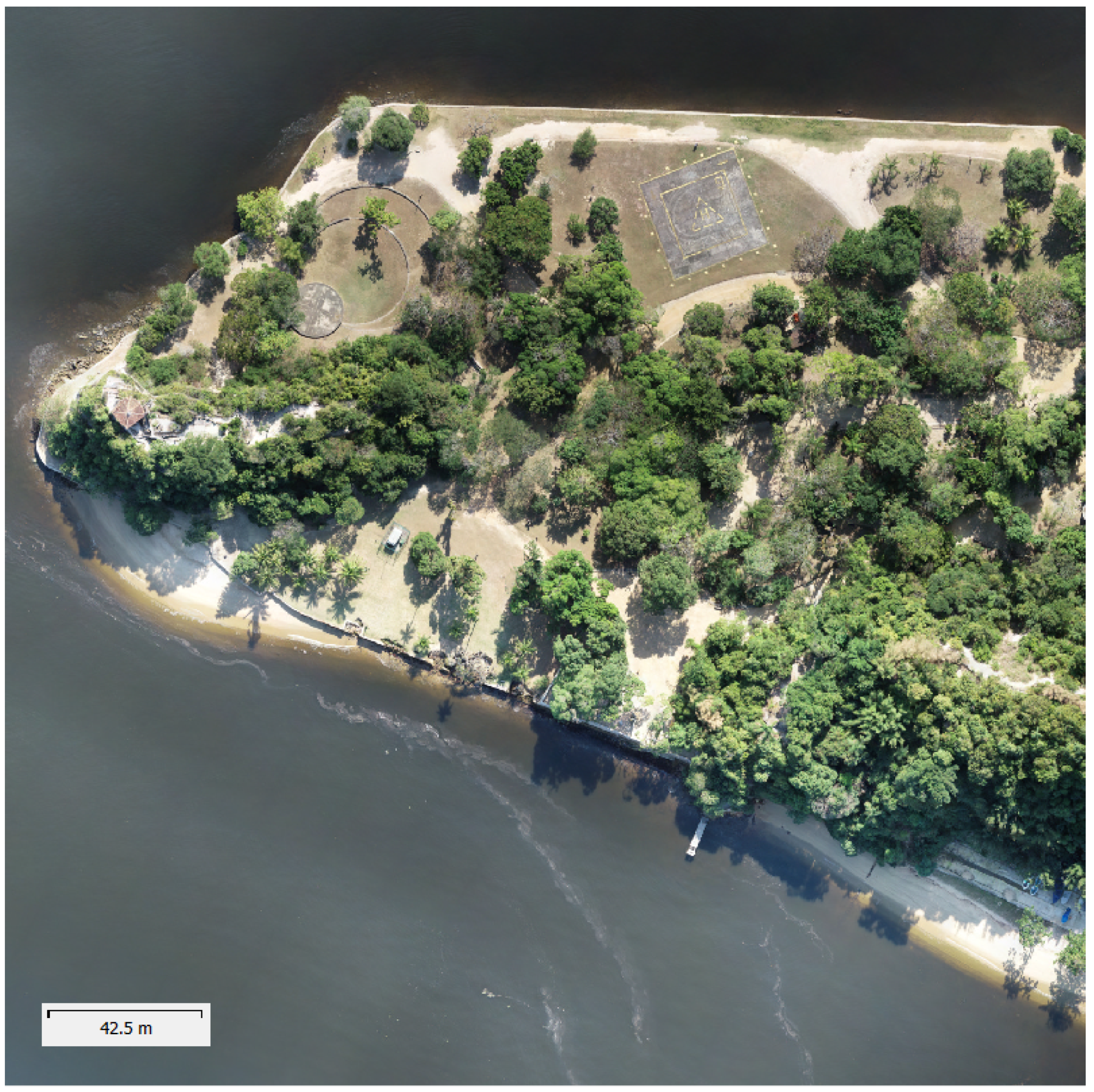
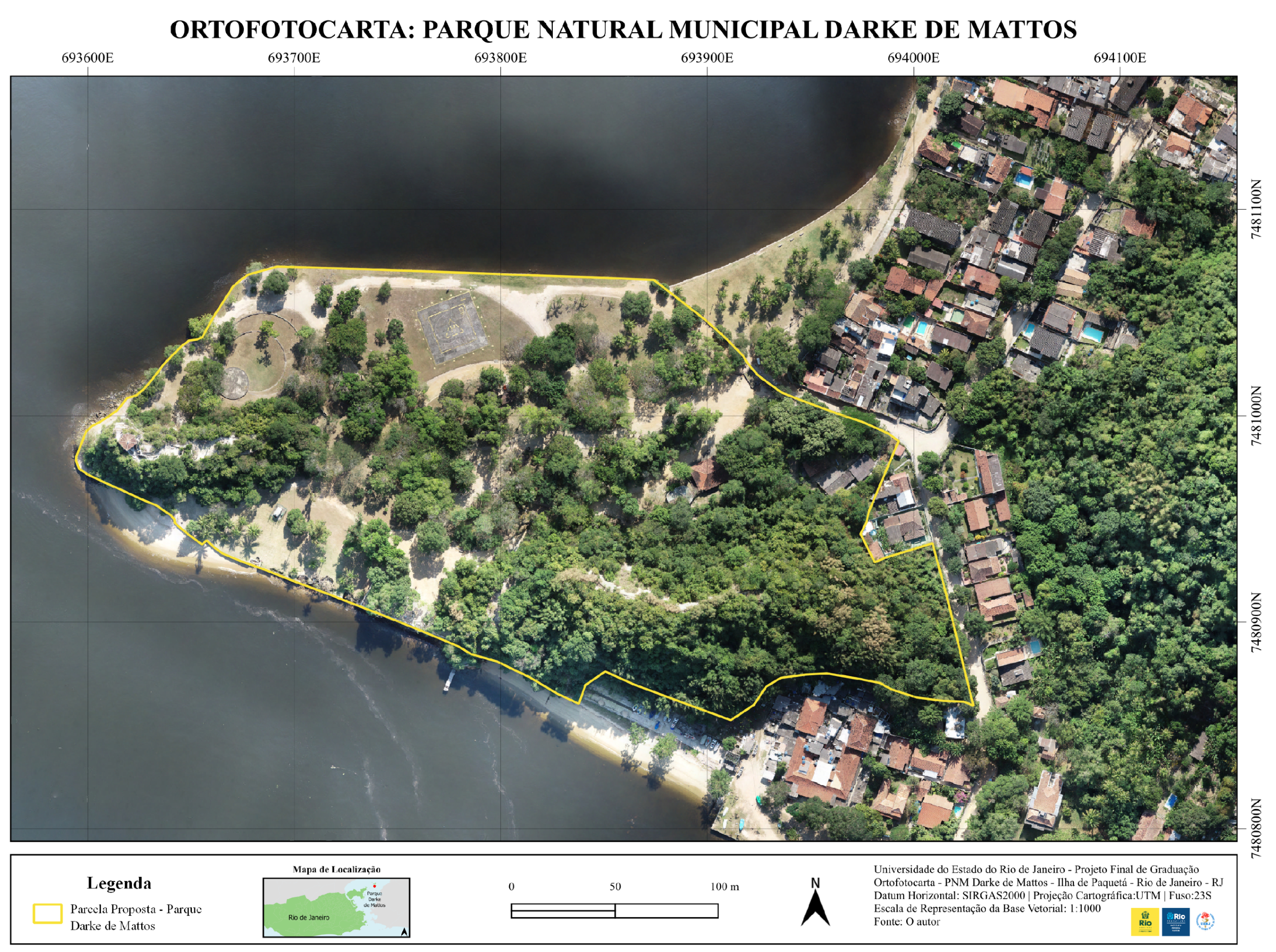
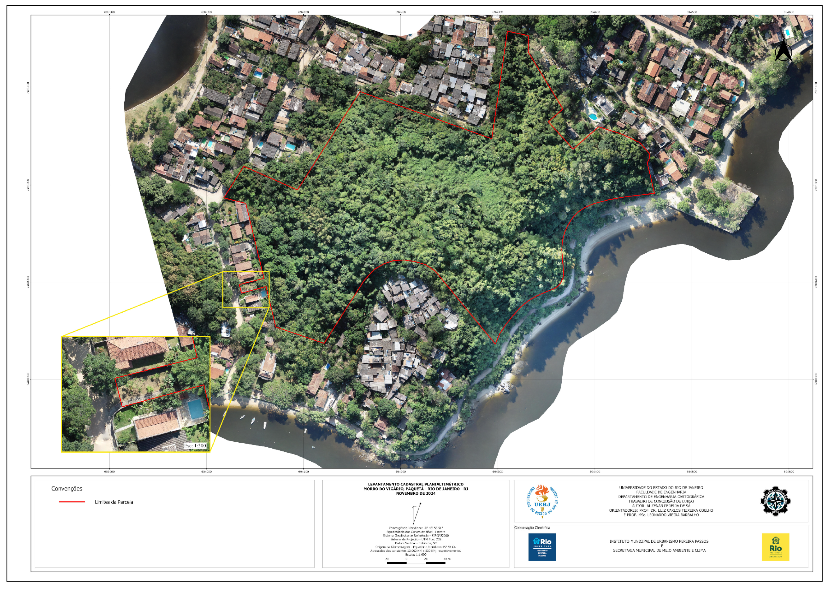
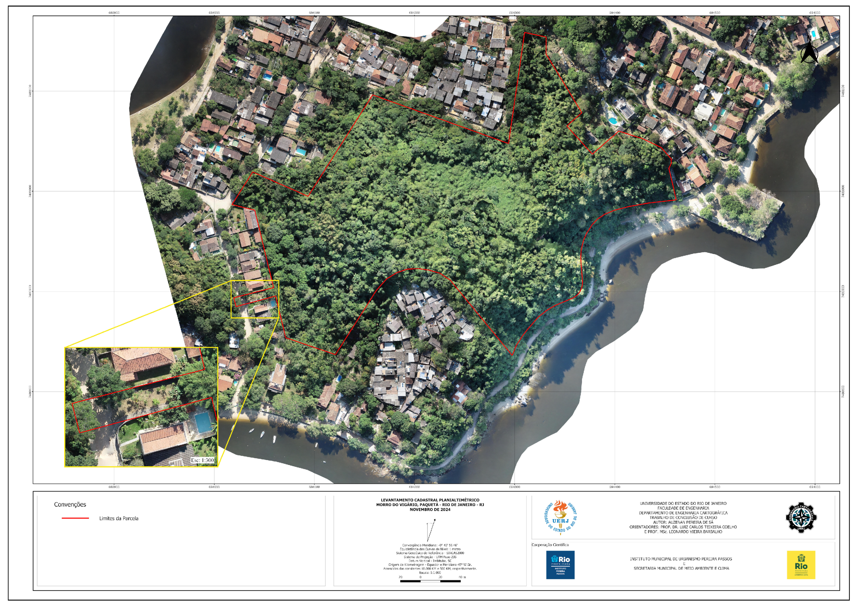
- An updated orthophoto map of Darke de Mattos Park, showing its current physical boundaries;
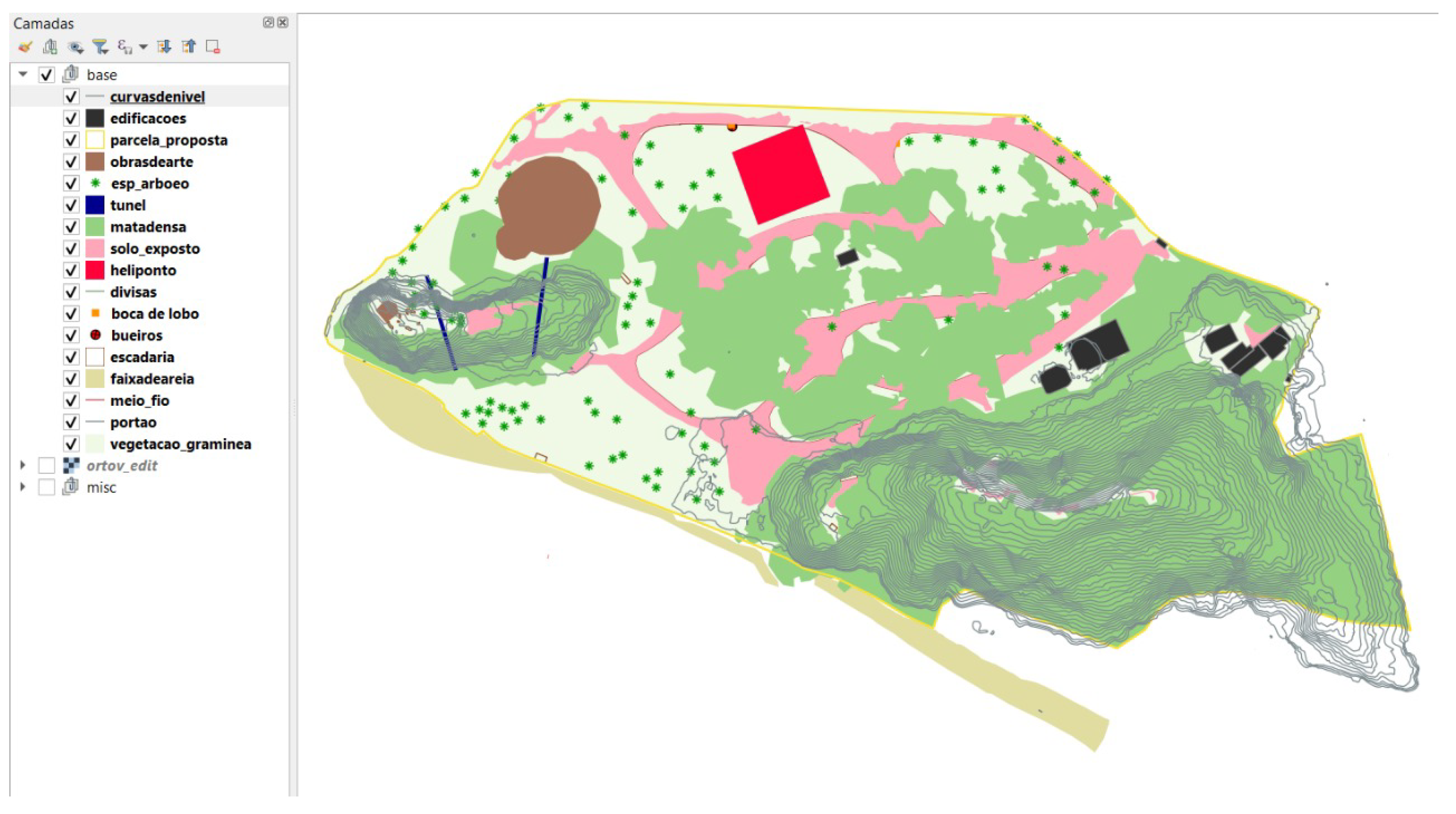
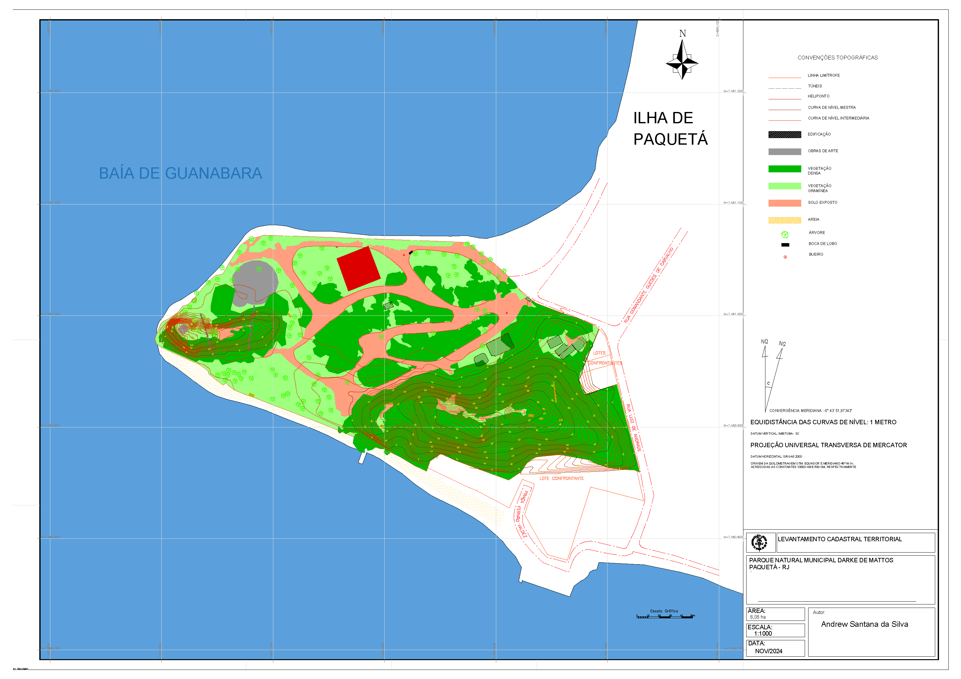
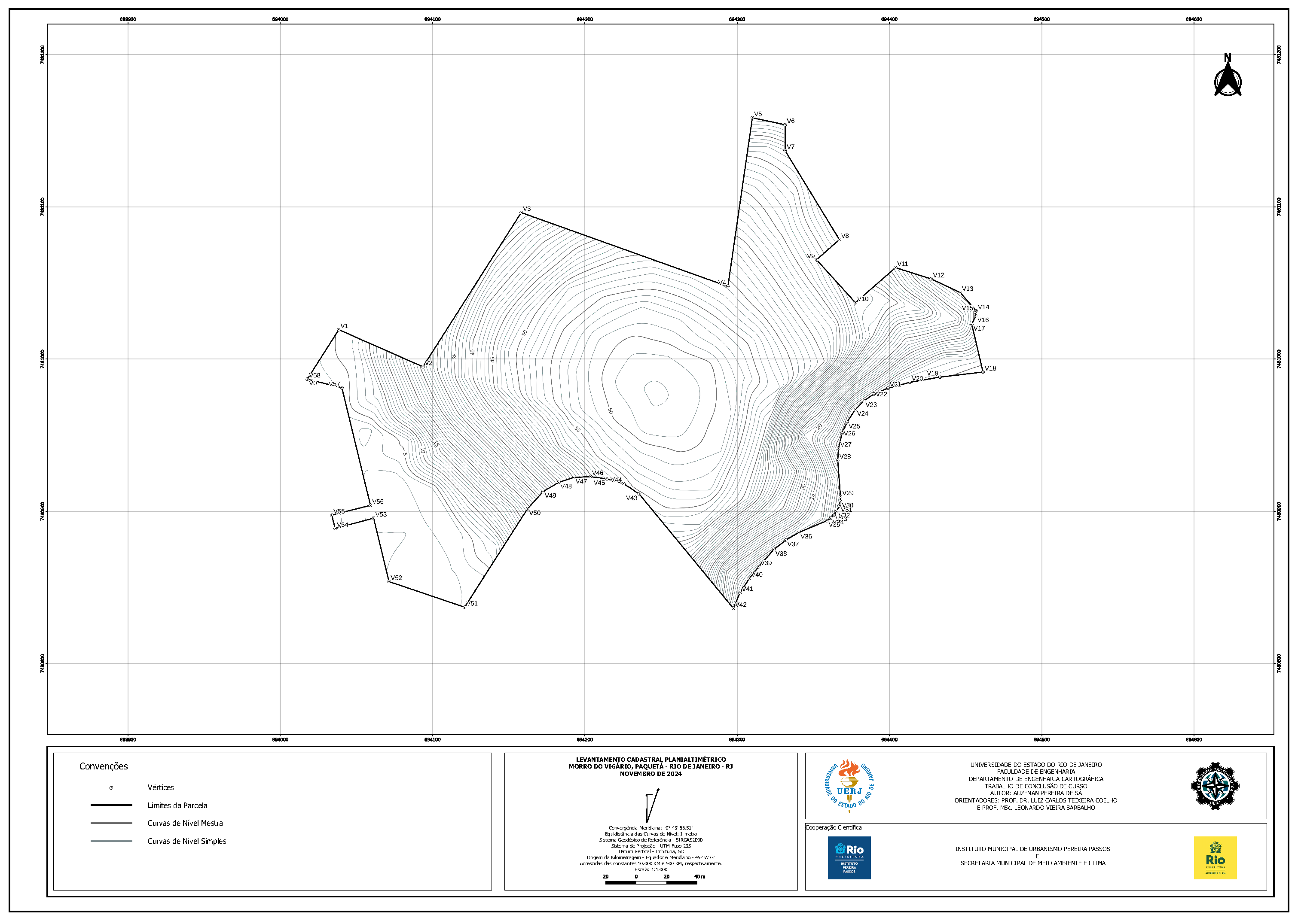
- A vector feature dataset and a 1:1000 plan of Darke de Mattos Park, showing its current physical boundaries;
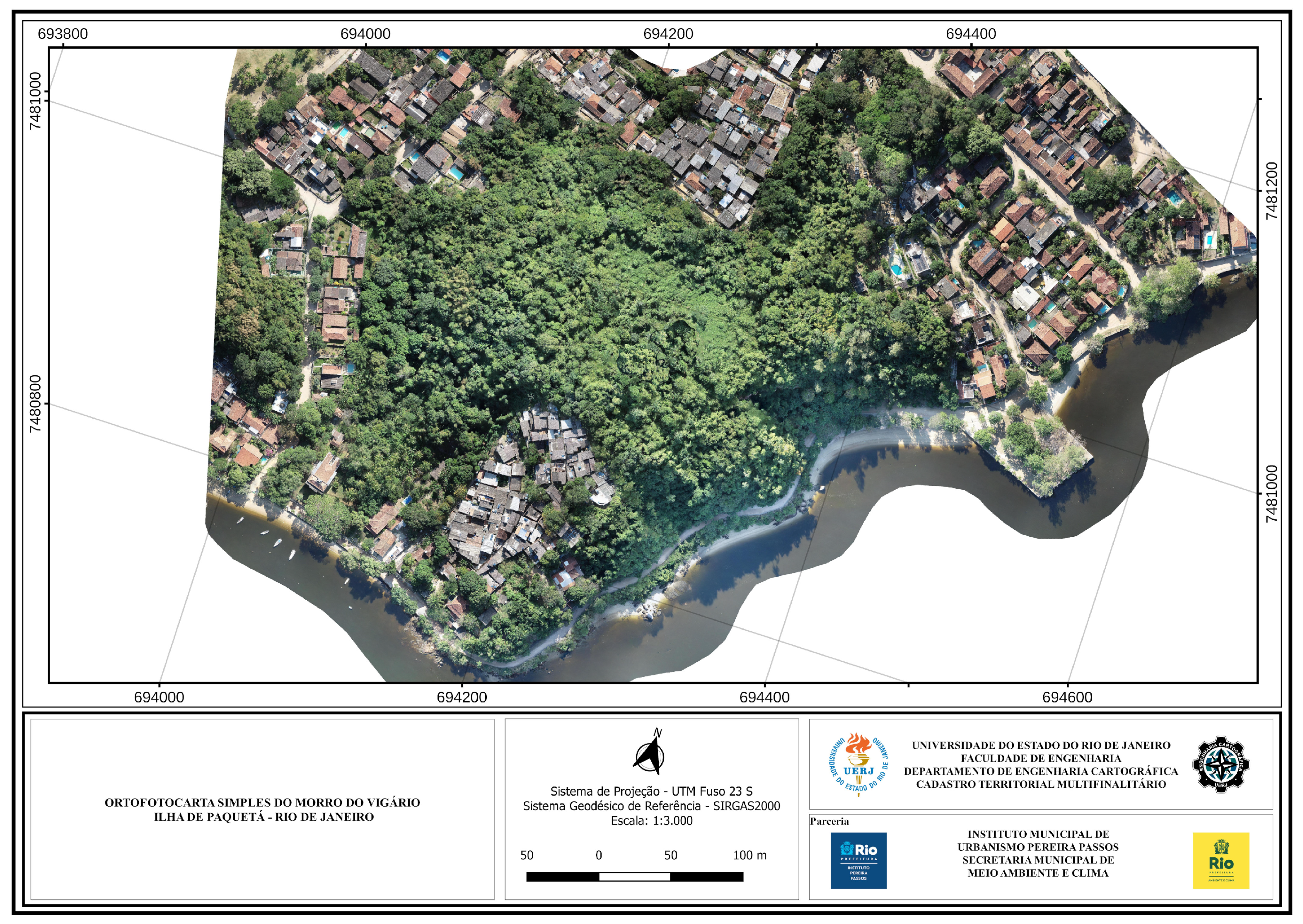
- An orthophoto map of the surroundings of Darke de Mattos Park, including Morro do Vigário;
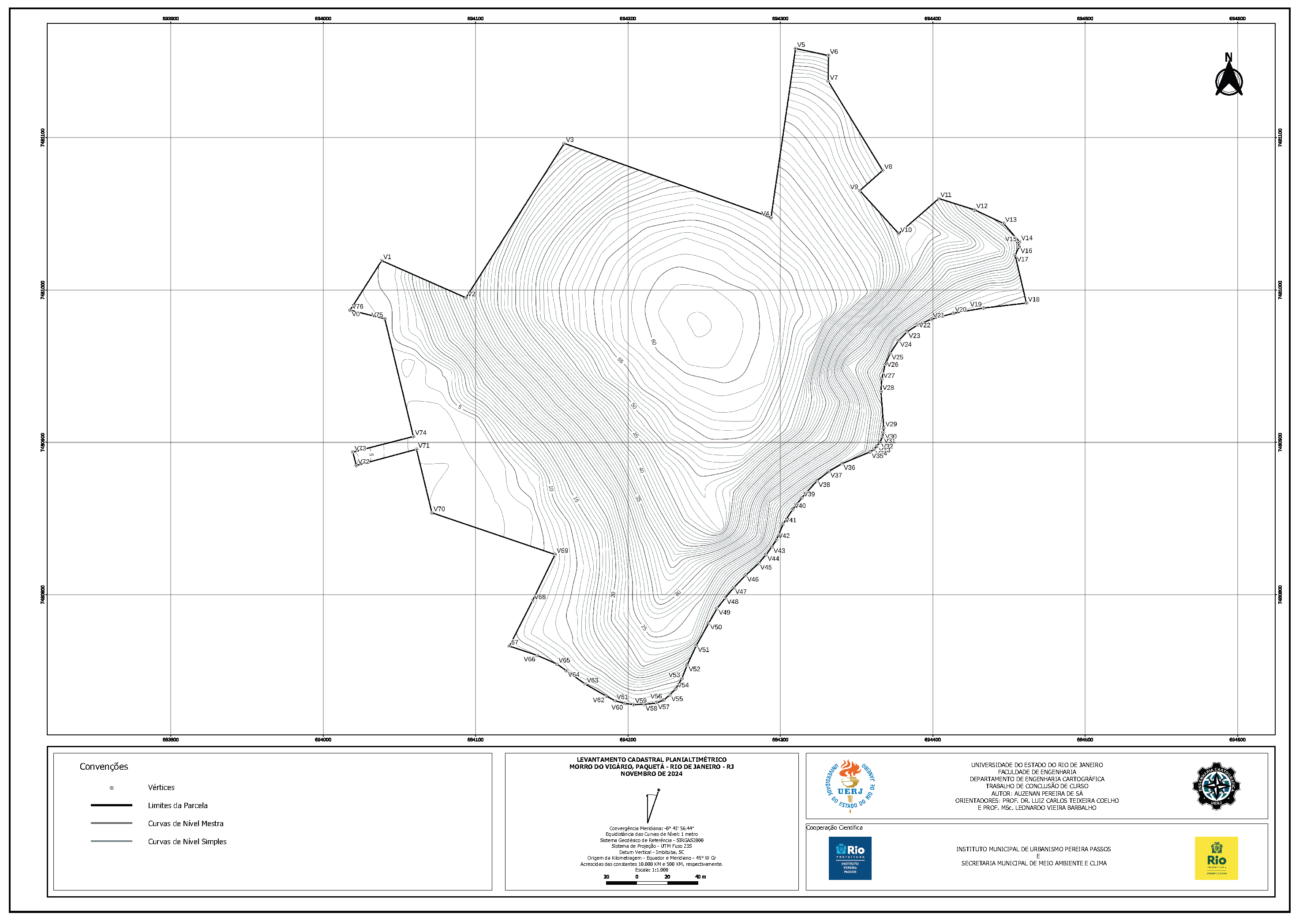
- A series of four different plans, integrating Morro do Vigário into the parcel that encompasses Darke de Mattos Park, thus allowing for its possible expansion.
4. Results
4.1. GNSS Processing of Ground Control Points
4.2. Photogrammetric Bundle Block Adjustment
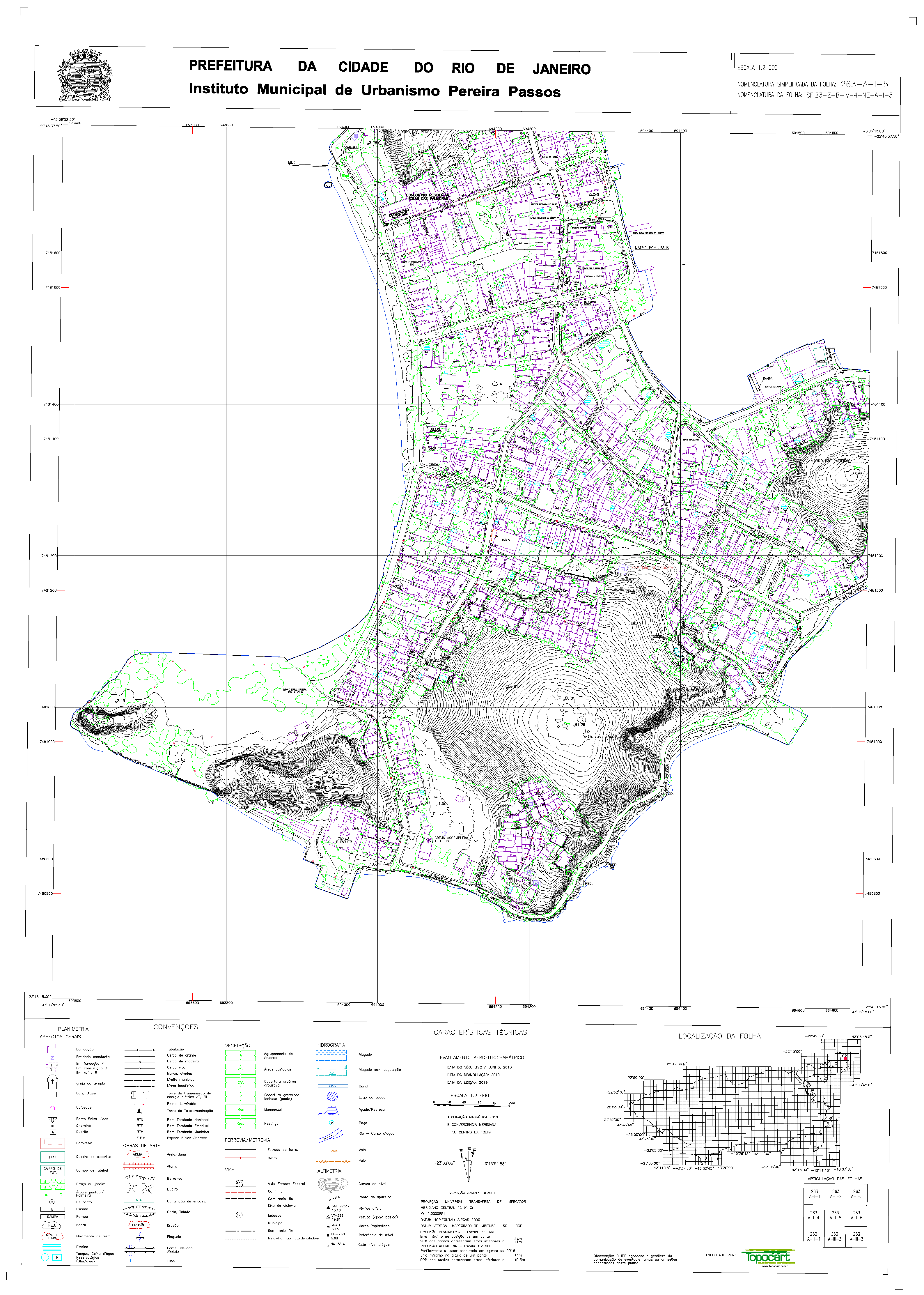
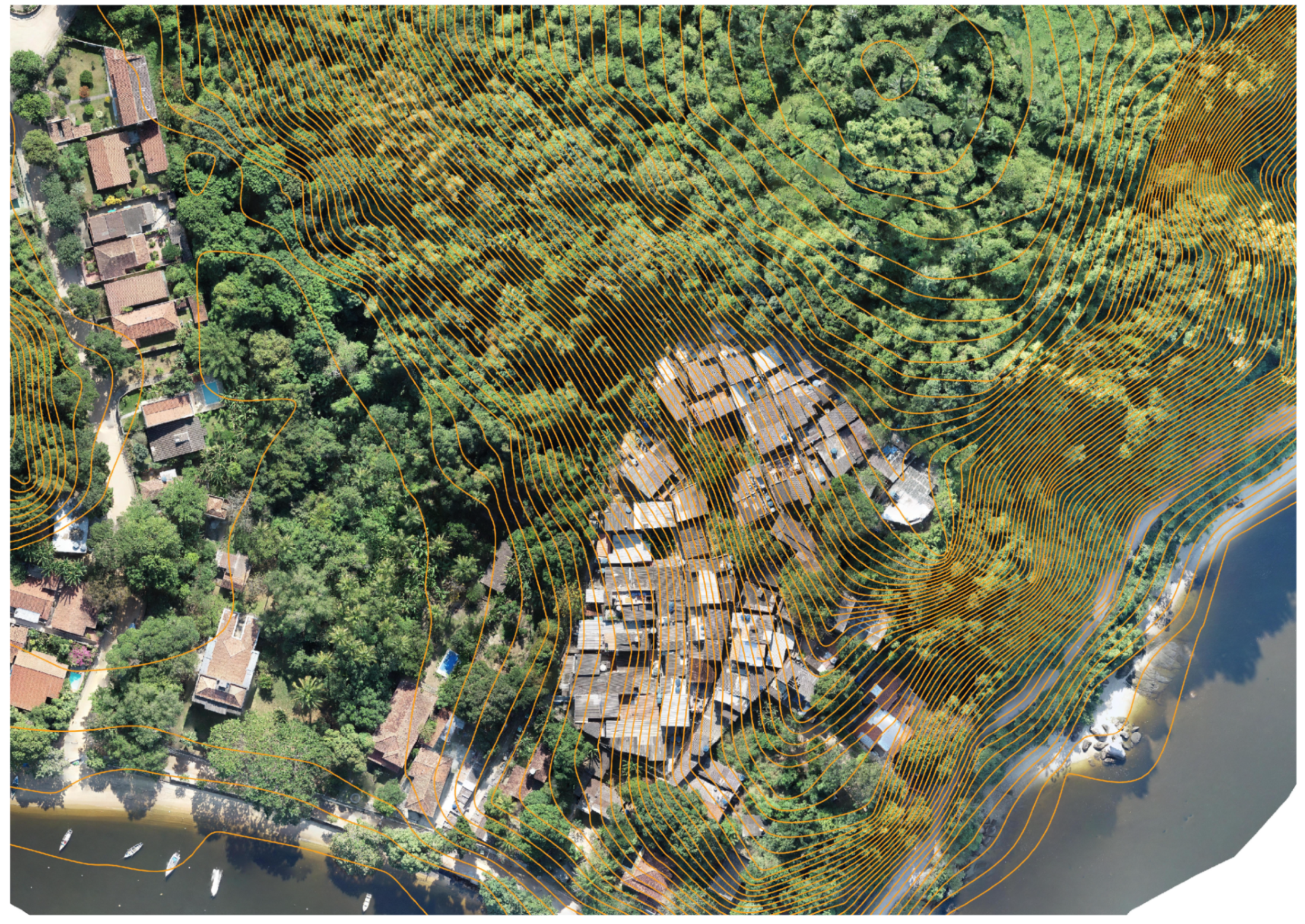
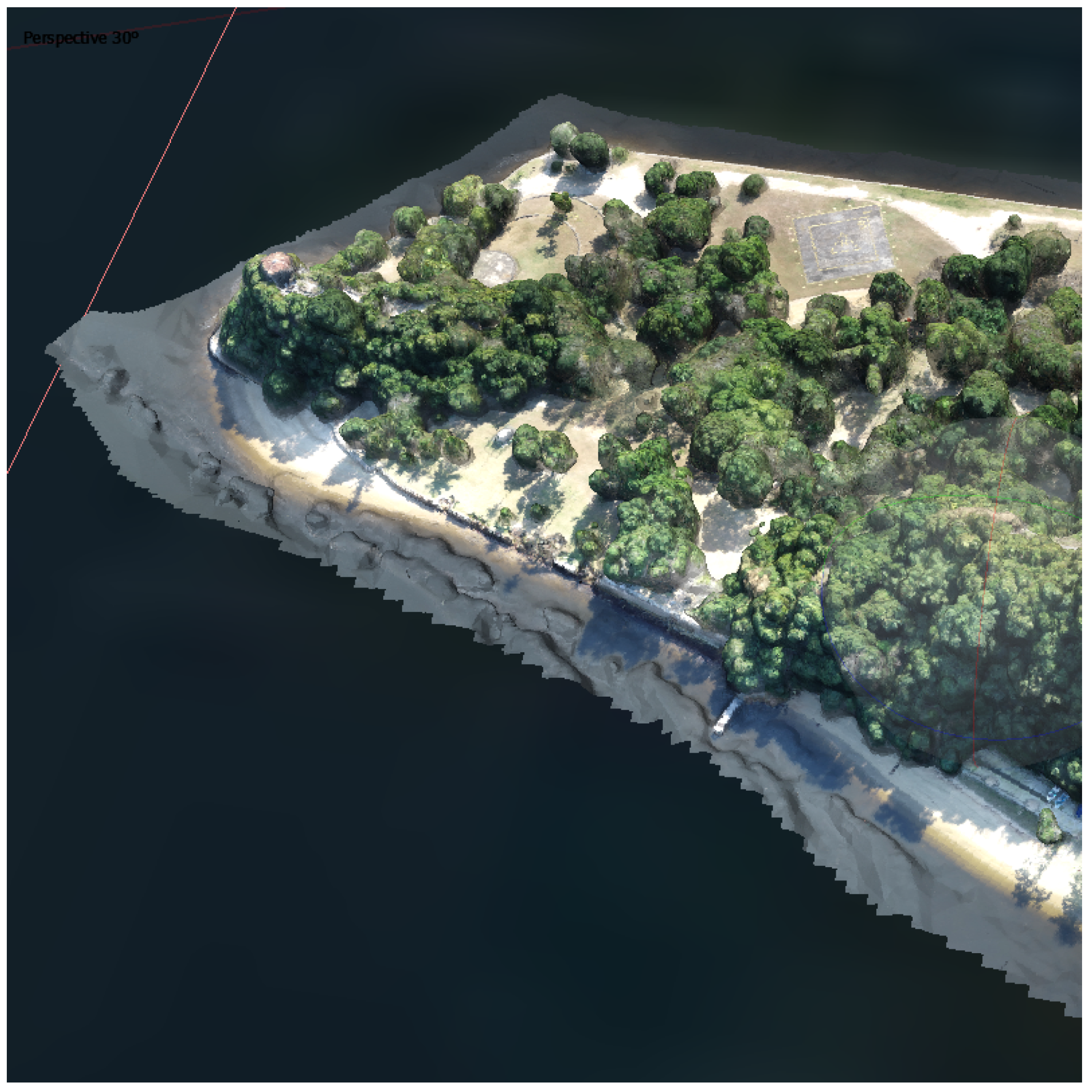
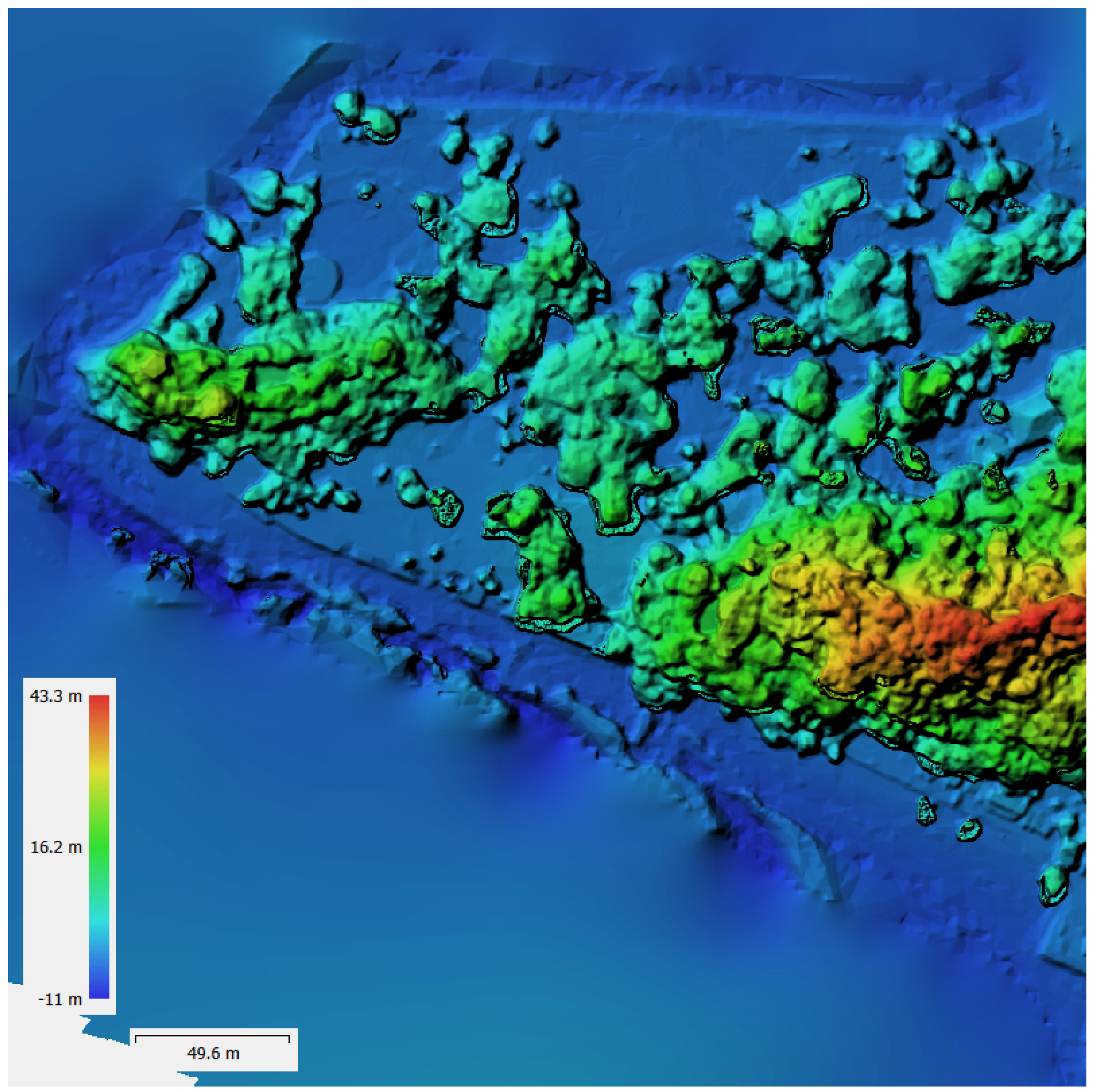
4.3. Orthophoto Maps
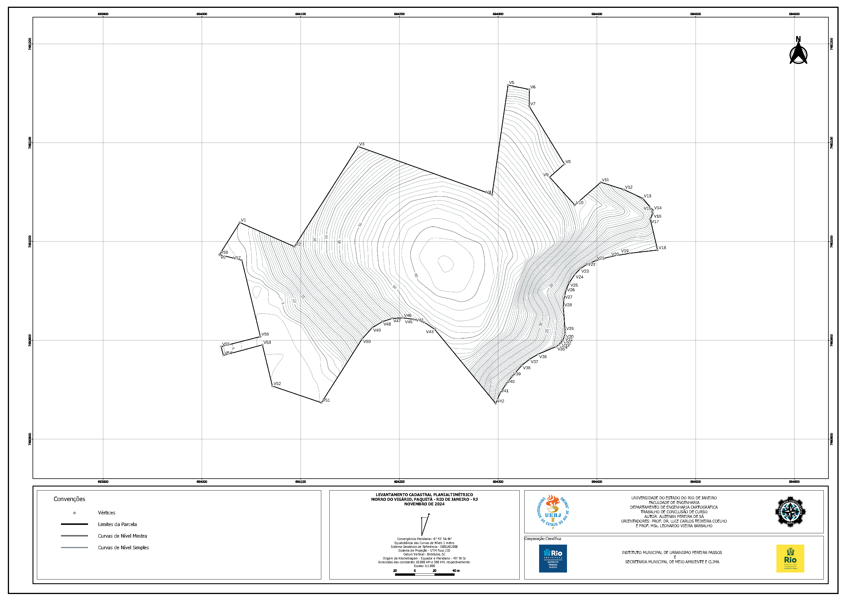
4.4. Vector Data Layers and Topographic Map of Darke de Mattos Natural Park
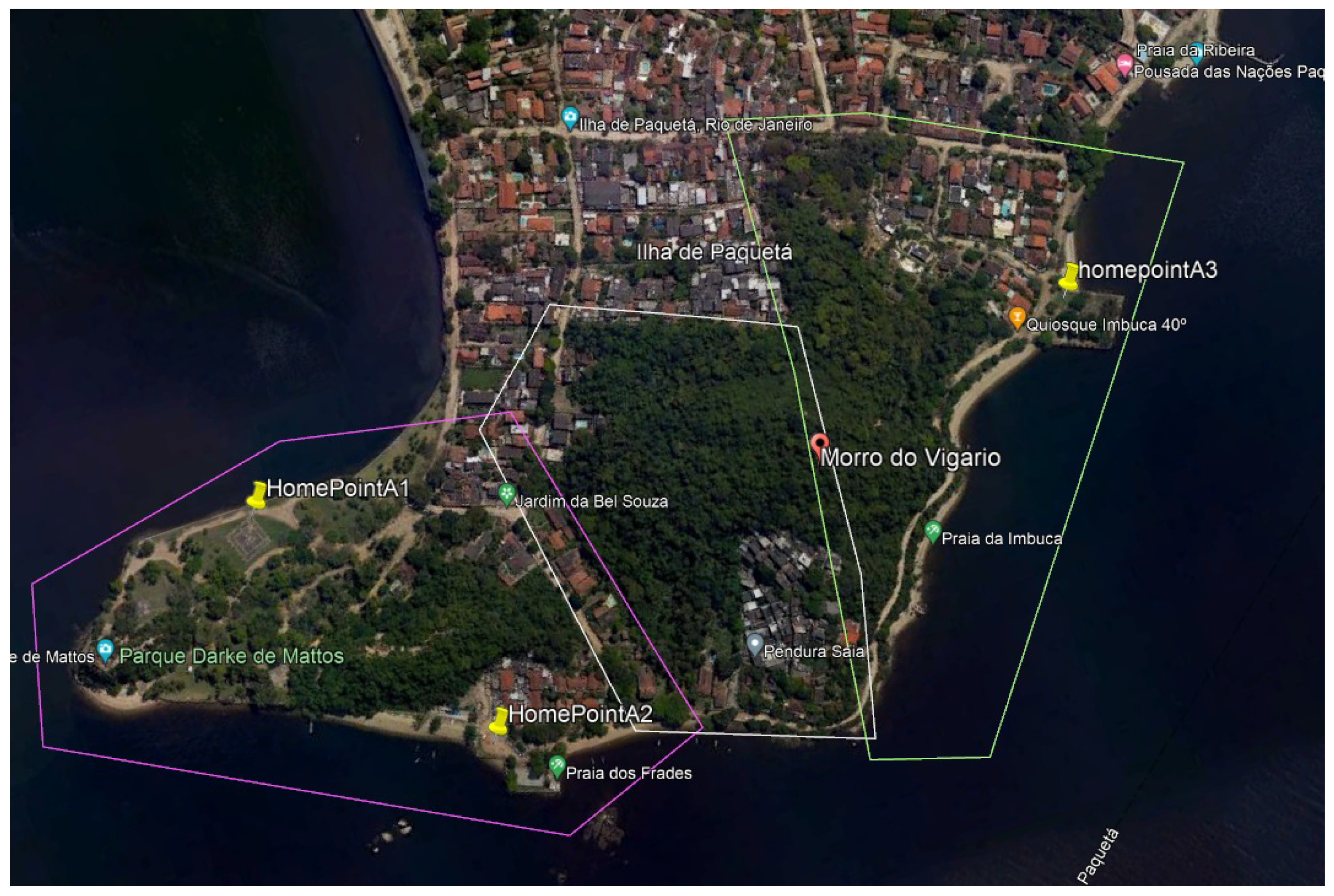
4.5. Proposed Scenarios for the New Parcel Integrating Morro do Vigário into Darke de Mattos Natural Park
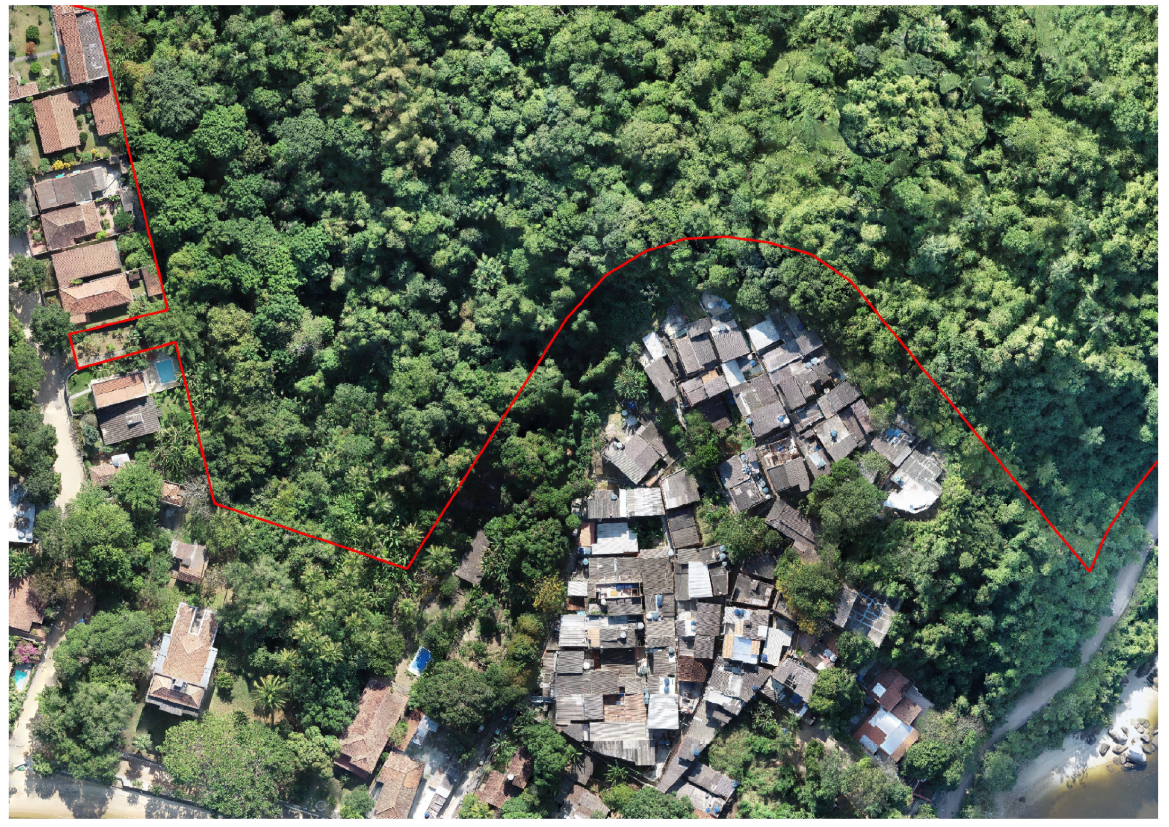
4.5.1. Methodological Proposal 1: Disconnected Parcel Excluding the Favela Area
4.5.2. Methodological Proposal 2: Disconnected Parcel Including the Favela Area
4.5.3. Methodological Proposal 3: Park-Connected Parcel Excluding the Favela Area
4.5.4. Methodological Proposal 4: Park-Connected Parcel Including the Favela Area
5. Discussion
5.1. Affordability and Scientific Significance of this Methodology
5.2. Determination of the Darke de Mattos Natural Park’s Limits
5.3. Parcelling Scenarios and Further Expansion of Darke de Mattos to Encompass Morro do Vigário
5.4. Darke de Mattos Park’s Cadastral Survey Within the Framework of Fit-for-Purpose Land Administration
5.5. Future Studies and Improvements
6. Conclusions
- The establishment of permanent geodetic control points;
- Quarterly monitoring through repeat UAV surveys;
- The formal adoption of boundaries through municipal decrees;
- Integrated land-use policies addressing both conservation and community needs.
Author Contributions
Funding
Institutional Review Board Statement
Informed Consent Statement
Data Availability Statement
Acknowledgments
Conflicts of Interest
Abbreviations
| AEIS | Area of Special Social Interest (Área de Especial Interesse Social ) |
| APAC | Area of Cultural Environmental Protection (Área de Proteção Ambiental Cultural) |
| CNN | Convolutional Neural Network |
| CR | Critically Endangered |
| DECEA | Department of Airspace Control (Departamento de Controle do Espaço Aéreo) |
| DEM | Digital Elevation Model |
| DSG | Geographic Service Directorate (Diretoria de Serviço Geográfico) |
| DSM | Digital Surface Model |
| DTM | Digital Terrain Model |
| FFPLA | Fit-for-Purpose Land Administration |
| GCP | Ground Control Point |
| GIS | Geographical Information Systems |
| GNSS | Global Navigation Satellite System |
| GSD | Ground-Sampling Distance |
| IBGE | Brazilian Institute of Geography and Statistics (Instituto Brasileiro de Geografia e Estatística) |
| INCRA | National Institute for Colonization and Agrarian Reform |
| (Instituto Nacional de Colonização e Reforma Agrária) | |
| IPP | Pereira Passos Municipal Institute of Urban Planning |
| (Instituto Municipal de Urbanismo Pereira Passos) | |
| LADM | (Land Administration Domain Model) |
| LiDAR | Light Detection and Ranging |
| LULC | Land Use Land Cover |
| MLC | Multipurpose Land Cadastre |
| PAL | Approved Parcelling Project (Projeto Aprovado de Loteamento) |
| PNM | Municipal Natural Park (Parque Natural Municipal) |
| PPA | Permanent Preservation Areas |
| RBMC | Brazilian Network for Continuous Monitoring (Rede Brasileira de Monitoramento Contínuo) |
| RGI | General Registry of Real Estate (Registro Geral de Imóveis) |
| RMSE | Root-Mean-Square Error |
| RPA | Remotely Piloted Aircraft |
| RTK | Real-Time Kinematic |
| SDG | Sustainable Development Goals |
| SGB | Brazilian Geodetic System (Sistema Geodésico Brasileiro) |
| SIRGAS | Geocentric Reference System for the Americas |
| STDM | Social Tenure Domain Model |
| UAV | Unmanned Aerial Vehicle |
| UTM | Universal Transverse Mercator |
References
- Grise, M.M.; Biondi, D.; Araki, H. A floresta urbana da cidade de Curitiba, PR. Floresta 2016, 46, 425–438. [Google Scholar] [CrossRef]
- Jamean, E.S.; Abas, A. Valuation of Visitor Perception of Urban Forest Ecosystem Services in Kuala Lumpur. Land 2023, 12, 572. [Google Scholar] [CrossRef]
- Wu, Z.; Chen, R.; Meadows, M.E.; Sengupta, D.; Xu, D. Changing urban green spaces in Shanghai: Trends, drivers and policy implications. Land Use Policy 2019, 87, 104080. [Google Scholar] [CrossRef]
- Dickinson, D.C.; Ramalho, C.E. A balancing act: Biodiversity and human wellbeing considerations in the management of urban forest in a global biodiversity hotspot. Urban For. Urban Green. 2022, 74, 127656. [Google Scholar] [CrossRef]
- Pesola, L.; Cheng, X.; Sanesi, G.; Colangelo, G.; Elia, M.; Lafortezza, R. Linking above-ground biomass and biodiversity to stand development in urban forest areas: A case study in Northern Italy. Landsc. Urban Plan. 2017, 157, 90–97. [Google Scholar] [CrossRef]
- Giacinto, J.J.; Fricker, G.A.; Ritter, M.; Yost, J.; Doremus, J. Urban forest biodiversity and cardiovascular disease: Potential health benefits from California’s street trees. PLoS ONE 2021, 16, e0254973. [Google Scholar] [CrossRef]
- Alvey, A.A. Promoting and preserving biodiversity in the urban forest. Urban For. Urban Green. 2006, 5, 195–201. [Google Scholar] [CrossRef]
- Lima, B.V.; Amaral, R.D.d.A.M.; Souza, C.A.; Longo, M.H.C. Perception about urban forest and its influence on well-being in workplaces. Ambiente Soc. 2023, 26, e02201. [Google Scholar] [CrossRef]
- Nesbitt, L.; Hotte, N.; Barron, S.; Cowan, J.; Sheppard, S.R. The social and economic value of cultural ecosystem services provided by urban forests in North America: A review and suggestions for future research. Urban For. Urban Green. 2017, 25, 103–111. [Google Scholar] [CrossRef]
- Singh, K.; Gagné, S.; Meentemeyer, R. 9.22-Urban Forests and Human Well-Being. In Comprehensive Remote Sensing; Liang, S., Ed.; Elsevier: Oxford, UK, 2018; pp. 287–305. [Google Scholar] [CrossRef]
- Cook, M. Using urban woodlands and forests as places for improving the mental well-being of people with dementia. Leis. Stud. 2020, 39, 41–55. [Google Scholar] [CrossRef]
- Geng, W.; Wan, Q.; Wang, H.; Dai, Y.; Weng, L.; Zhao, M.; Lei, Y.; Duan, Y. Leisure Involvement, Leisure Benefits, and Subjective Well-Being of Bicycle Riders in an Urban Forest Park: The Moderation of Age. Forests 2023, 14, 1676. [Google Scholar] [CrossRef]
- McPherson, E.G.; Nowak, D.; Heisler, G.; Grimmond, S.; Souch, C.; Grant, R.; Rowntree, R. Quantifying urban forest structure, function, and value: The Chicago Urban Forest Climate Project. Urban Ecosyst. 1997, 1, 49–61. [Google Scholar] [CrossRef]
- Massawe, G.P.; Marealle, W.N.; Liseki, S.D.; Camerini, G. Conservation of urban forest in Tanzania: Community attitudes towards Njiro forest, Arusha. East Afr. J. For. Agrofor. 2019, 1, 1–12. [Google Scholar] [CrossRef]
- Weng, L.; Zhu, Y.; Xu, X.; Yang, J.; Zheng, S.; Liu, H.; Wang, H.; Zhu, L. The influence of visitors’ recreation experience and environmental attitude on environmentally responsible behavior: A case study of an urban forest park, China. Forests 2022, 14, 24. [Google Scholar] [CrossRef]
- Simmons, D. Using natural settings for environmental education: Perceived benefits and barriers. J. Environ. Educ. 1998, 29, 23–31. [Google Scholar] [CrossRef]
- Angel, S.; Blei, A.M.; Civco, D.L.; Parent, J. Atlas of Urban Expansion; Lincoln Institute of Land Policy: Cambridge, MA, USA, 2012. [Google Scholar]
- Zhao, M.; Escobedo, F.J.; Staudhammer, C. Spatial patterns of a subtropical, coastal urban forest: Implications for land tenure, hurricanes, and invasives. Urban For. Urban Green. 2010, 9, 205–214. [Google Scholar] [CrossRef]
- Konijnendijk, C.C.; Gauthier, M. Urban forestry for multifunctional urban land use. In Cities Farming for the Future: Agriculture for Green and Productive Cities; van Veenhuizen, R., Ed.; RUAF Foundation: Rome, Italy, 2006; pp. 414–416. [Google Scholar]
- Tyrväinen, L.; Miettinen, A. Property prices and urban forest amenities. J. Environ. Econ. Manag. 2000, 39, 205–223. [Google Scholar] [CrossRef]
- Drosos, V.C. CADASTRE (forest maps) and spatial land uses planning, strategic tool for sustainable development. In Proceedings of the Second International Conference on Remote Sensing and Geoinformation of the Environment (RSCy2014), Paphos, Cyprus, 7–10 April 2014; SPIE: San Francisco, CA, USA, 2014; Volume 9229, pp. 421–429. [Google Scholar]
- Vordoglou, M.; Samara, T.; Tsitsoni, T. The contribution of the cadaster to the protection of urban forests. The case study of Seich Sou. In Proceedings of the 16th International Conference on Environmental Science and Technology, Rhodes, Greece, 4–7 September 2019. [Google Scholar]
- Noe, N.; Massi, F. Urban Forest Digital Cadastre. J. Civ. Eng. Archit. 2021, 15, 330–341. [Google Scholar]
- Elshad, J.T.; Musa, T.J. Provision of urban planning cadastre with information systems. In Proceedings of the XII International Scientific and Practical Conference “The Process of Science Formation and Its Contemporary Appearance”, Tampere, Finland, 20–21 March 2023; p. 73. [Google Scholar]
- Loch, C.; Erba, D.A. Cadastro técnico Multifinalitário: Rural e Urbano; Lincoln Institute of Land Policy: Cambridge, MA, USA, 2007. [Google Scholar]
- Erba, D.; Piumetto, M. Catastro Territorial Multifinalitario; Lincoln Institute of Land Policy: Cambridge, MA, USA, 2013. [Google Scholar]
- Erba, D.A.; Piumetto, M.A. Para Leer el Suelo Urbano: Catastros Multifinalitarios Para la Planificacion y el Desarrollo de Las Ciudades de America Latina; Lincoln Institute of Land Policy: Cambridge, MA, USA, 2016. [Google Scholar]
- Coelho, L.C.T.; Barbalho, L.V.; Lima, F.R. As novas normativas do Cadastro Territorial Multifinalitário no Brasil como ferramentas de planejamento e gestão urbanos participativos. e-metropolis: Revista eletrônica de estudos urbanos e regionais 2025. Available online: https://revistas.ufrj.br/index.php/emetropolis/article/view/62587 (accessed on 2 June 2025).
- Queiroz, A.O. Cidades inteligentes: O papel do cadastro territorial multifinalitário como ferramenta de gestão e planejamento. GC Rev. Nac. Gerenciamento Cid. 2019, 6. [Google Scholar] [CrossRef]
- Erba, D.; Loch, C. Impactos da Evolução Tecnológica na Legislação Territorial e no Cadastro Multifinalitário; Universidade Federal de Uberlândia: Uberlândia, Brazil, 2019. [Google Scholar]
- Mamonov, K.; Kukhar, M.; Shterndok, E.; Kamchatna, S. Standardization of geodetic data for determination of boundaries of natural reserve areas. In Proceedings of the E3S Web of Conferences, Tamilnadu, India, 22–23 November 2023; Volume 452, p. 03001. [Google Scholar]
- Sundell, R.C. The Use of Spatial Modeling to Evaluate Park Boundaries and Delineate Critical Resource Areas; Northwestern University: Evanston, IL, USA, 1991. [Google Scholar]
- Ling, Y.; Xu, J.; Sun, Y.; Shen, R.; Jiang, Y.; Wang, Y. How to Delineate the Boundaries of National Parks in Human-Land Conflict Areas–Evidence from Huangshan National Park Construction Area in China. Pol. J. Environ. Stud. 2024, 33, 3293–3309. [Google Scholar] [CrossRef]
- Brandão, A.C.; Carneiro, A.F.T.; Philips, J.W. Atualidades, desafios e perspectivas do Cadastro no Brasil. In Proceedings of the 1º International Congress on Unified and Multipurpose Cadastre, Jaén, Spain, 16–18 June 2010; Universidad de Jaén: Jaén, Spain, 2010. [Google Scholar]
- Cabral, C.R.; Hasenack, M.; de França, R.M.; de Araújo, A.L.; Boscatto, F. Uma proposta de Cadastro Territorial para o Brasil. Rev. Bras. Cartogr. 2020, 72. [Google Scholar] [CrossRef]
- Freitas, C.F.S.; Lima, L.S. Cadastro territorial e SIG no processo de regularização fundiária: O caso das ZEIS do Planalto Pici em Fortaleza, Ceará. In Proceedings of the IV Simpósio Brasileiro de Ciências Geodésicas e Tecnologias da Geoinformação, Recife, Brazil, 6–9 March 2012; UFPE: Recife, Brazil, 2012. [Google Scholar]
- De Sousa Aguiar, L.; Amaro, V.E.; Do Nascimento Araújo, P.V.; Silva Dos Santos, A.L. Low cost geotechnology applied to flood risk assessment in coastal urban areas in climate change scenarios. Anu. Do Inst. de Geociencias 2019, 42, 267–290. [Google Scholar] [CrossRef]
- Dos Santos, L.M.; Ferraz, G.A.E.S.; Barbosa, B.D.S.; Andrade, A.D. Use of remotely piloted aircraft in precision agriculture: A review. DYNA (Colombia) 2019, 86, 284–291. [Google Scholar] [CrossRef]
- Mulahusić, A.; Tuno, N.; Topoljak, J.; Ćatić, J. Comparison and Analysis of Two UAVs 3D Models of Medium and High Quality. In Proceedings of the Advanced Technologies, Systems, and Applications VII, Tuzla, Bosnia and Herzegovina, 1–4 June 2023; Ademović, N., Mujčić, E., Mulić, M., Kevrić, J., Akšamija, Z., Eds.; Springer International Publishing: Cham, Switzerland, 2023; pp. 536–550. [Google Scholar]
- Brasil. Lei Nº 10.257, de 10 de julho de 2001. Regulamenta os Arts. 182 e 183 da Constituição Federal, Estabelece Diretrizes Gerais da Política Urbana e dá Outras Providências. 2001. Available online: https://www.planalto.gov.br/ccivil_03/leis/leis_2001/l10257.htm (accessed on 14 December 2024).
- Prefeitura da Cidade do Rio de Janeiro. Lei Complementar Nº 270, de 16 de janeiro de 2024. Dispõe sobre a Política Urbana e Ambiental do Município, institui arevisão do Plano Diretor deDesenvolvimento UrbanoSustentável do Município do Riode Janeiro e dá Outras Providências. 2024. Available online: https://aplicnt.camara.rj.gov.br/APL/Legislativos/contlei.nsf/a99e317a9cfec383032568620071f5d2/0274835ddbc09b5303258aa700487674?OpenDocument (accessed on 14 December 2024).
- Associação Brasileira de Normas Técnicas. NBR 17047-Levantamento Cadastral Territorial para Registro Público-Procedimento. 2022. Available online: https://www.cartorioruibarbosa.com.br/wp-content/uploads/2023/12/NBR-17047.pdf (accessed on 14 December 2024).
- Diretoria de Serviço Geográfico-Exército Brasileiro. Especificação Técnica para Aquisição de Dados Geoespaciais Vetoriais (ET-ADGV v2.). 2016. Available online: https://geoportal.eb.mil.br/portal/index.php/normas/et-adgv (accessed on 14 December 2024).
- Coaracy, V. Paquetá-Imagens de ontem e de hoje; J. Olympio: São Paulo, Brazil, 1965. [Google Scholar]
- Carmona, R. Bonifácio, gênese do pensamento nacional. Tensões Mundiais 2013, 9, 196–215. [Google Scholar] [CrossRef]
- Prefeitura da Cidade do Rio de Janeiro. Declara de Utilidade Pública, Para Fins de Desapropriação, a área que Menciona, na Ilha de Paquetá. 1975. Available online: https://leismunicipais.com.br/a/rj/r/rio-de-janeiro/decreto/1975/20/199/decreto-n-199-1975-declara-de-utilidade-publica-para-fins-de-desapropriacao-a-area-que-menciona-na-ilha-de-paqueta (accessed on 14 December 2024).
- Prefeitura da Cidade do Rio de Janeiro. Retifica a Descrição de área a Que se Refere o Decreto nº 199, de 12 de Novembro de 1975. 1975. Available online: https://leismunicipais.com.br/a/rj/r/rio-de-janeiro/decreto/1975/25/259/decreto-n-259-1975-retifica-a-descricao-de-area-a-que-se-refere-o-decreto-n-199-de-12-de-novembro-de-1975 (accessed on 14 December 2024).
- Prefeitura da Cidade do Rio de Janeiro. Reconhece como Logradouro Público da Cidade do Rio de Janeiro, com Denominação Oficial Aprovada de Parque Darke de Mattos, a área que Menciona, Situada na XXI Região Administrativa-Ilha de Paquetá. 1976. Available online: https://leismunicipais.com.br/a/rj/r/rio-de-janeiro/decreto/1976/40/394/decreto-n-394-1976-reconhece-como-logradouro-publico-da-cidade-do-rio-de-janeiro-com-denominacao-oficial-aprovada-de-parque-darke-de-mattos-a-area-que-menciona-situada-na-xxi-regiao-administrativa-ilha-de-paquete (accessed on 14 December 2024).
- Prefeitura da Cidade do Rio de Janeiro. Decreto n° 17.555, de 18 de maio de 1999. Tomba Definitivamente os Bens que Menciona, Transforma a Ilha de Paquetá em Área de Proteção do Ambiente Cultural (APAC), e dá Outras Providências. 1999. Available online: https://www.rio.rj.gov.br/dlstatic/10112/4722991/4121961/153DECRETO17555APACIlhadePaqueta.pdf (accessed on 14 December 2024).
- Prefeitura da Cidade do Rio de Janeiro. Decreto Nº 22.662, de 19 de Fevereiro de 2003. Regulamenta o Art. 11, § 4o, Dispõe Sobre a Renomeação e a Gestão dos Parques Públicos municipais. 2003. Available online: https://leismunicipais.com.br/a/rj/r/rio-de-janeiro/decreto/2003/2266/22662/decreto-n-22662-2003-dispoe-sobre-a-renomeacao-e-a-gestao-dos-parques-publicos-municipais-considerados-como-unidades-de-conservacao-segundo-a-lei-n-9985-de-18-07-00-e-decreto-n-4-340-de-22-08-02-e-da-outras-providencias (accessed on 14 December 2024).
- Prefeitura da Cidade do Rio de Janeiro. Relatório de Gestão do Parque Natural Municipal Darke de Mattos; Gráfica da Cidade: Rio de Janeiro, Brazil, 2023. [Google Scholar]
- Lorenzi, H. Plantas Daninhas do Brasil: Terrestres, Aquáticas, Parasitas e Tóxicas, 3rd ed.; Instituto Plantarum de Estudo: Nova Odessa, Brazil, 2000. [Google Scholar]
- Secretaria Municipal de Meio Ambiente e Clima-Prefeitura da Cidade do Rio de Janeiro. Guia das Unidades de Conservação Ambiental do Rio de Janeiro; IBAM: Rio de Janeiro, Brazil, 1998. [Google Scholar]
- Bertola, L. Planta em Extinção é Reencontrada no Rio após 50 Anos Desaparecida. 2022. Available online: https://oglobo.globo.com/um-so-planeta/noticia/2022/09/planta-em-extincao-e-reencontrada-no-rio-apos-50-anos-desaparecida.ghtml (accessed on 13 November 2024).
- Martinelli, G.; Martins, E.; Moraes, M.; Loyola, R.; Amaro, R. Livro Vermelho da Flora Endêmica do Estado do Rio de Janeiro; Livros e Publicações-CNCFlora: Rio de Janeiro, Brazil, 2018. [Google Scholar]
- Instituto Chico Mendes de Conservação da Biodiversidade. Aplicação de Critérios e Categorias da UICN na Avaliação da Fauna Brasileira; ICMBio: Brasília, Brazil, 2013. [Google Scholar]
- Instituto Brasileiro de Geografia e Estatística. Solução Multianual das Estações da Rede Brasileira de Monitoramento Contínuo dos Sistemas GNSS no Período de 2000 a 2019; IBGE: Rio de Janeiro, Brazil, 2021. [Google Scholar]
- Prefeitura da Cidade do Rio de Janeiro. Lei Nº 3.279, de 24 de Setembro de 2001. Declara como Áreas de Especial Interesse Social, para fins de Urbanização e Regularização, as áreas que Menciona, e Estabelece os Respectivos Padrões Especiais de Urbanização. 2001. Available online: https://cmrj.nopapercloud.com.br/Arquivo/Documents/legislacao/html/L32792001.html (accessed on 14 December 2024).
- Barbalho, L.V. Os Desafios na Implementação do Cadastro Territorial Multifinalitário no Município do Rio de Janeiro; Universidade Federal do Rio de Janeiro: Rio de Janeiro, Brazil, 2020. [Google Scholar]
- Cunha, E.M.P.; Erba, D.A. Manual de Apoio–CTM: Diretrizes Para a Criação, Instituição e Atualização do Cadastro Territorial Multifinalitário nos Municípios Brasileiros; Ministério das Cidades: Brasília, Brazil, 2010. [Google Scholar]
- Arévalo-Verjel, A.N.; Lerma, J.L.; Prieto, J.F.; Carbonell-Rivera, J.P.; Fernández, J. Estimation of the Block Adjustment Error in UAV Photogrammetric Flights in Flat Areas. Remote Sens. 2022, 14, 2877. [Google Scholar] [CrossRef]
- Seeber, G. Satellite Geodesy; Walter de Gruyter: Berlin, Germany, 2003. [Google Scholar]
- Instituto Nacional de Colonização e Reforma Agrária. Manual Técnico Para Georreferenciamento de Imóveis Rurais, 2nd ed.; Instituto Nacional de Colonização e Reforma Agrária: Brasília, Brazil, 2022. [Google Scholar]
- Instituto Brasileiro de Geografia e Estatística. Rede Brasileira de Monitoramento Contínuo dos sistemas GNSS (RBMC). 2022. Available online: https://www.ibge.gov.br/geociencias/informacoes-sobre-posicionamento-geodesico/rede-geodesica/16258-rede-brasileira-de-monitoramento-continuo-dos-sistemas-gnss-rbmc.html (accessed on 13 November 2024).
- Monico, J.F.G. Posicionamento pelo GNSS: Descrição, Fundamentos e Aplicaçoes, 2nd ed.; UNESP: São Paulo, Brazil, 2008. [Google Scholar]
- Hofmann-Wellenhof, B.; Lichtenegger, H.; Collins, J. GPS Theory and Practice, 5th ed.; Springer: Vienna, Austria, 2001. [Google Scholar]
- Fortes, L.P.S. Posicionamento Geodésico por Satélites Artificiais—Notas de Aula e Apostila; Universidade do Estado do Rio de Janeiro: Rio de Janeiro, Brazil, 2024. [Google Scholar]
- Garcia, M.V.Y.; Oliveira, H.C. The Influence of Ground Control Points Configuration and Camera Calibration for Dtm and Orthomosaic Generation Using Imagery Obtained from a Low-Cost Uav. ISPRS Ann. Photogramm. Remote Sens. Spat. Inf. Sci. 2020, V-1-2020, 239–244. [Google Scholar] [CrossRef]
- de Lima, R.S.; Lang, M.; Burnside, N.G.; Peciña, M.V.; Arumäe, T.; Laarmann, D.; Ward, R.D.; Vain, A.; Sepp, K. An Evaluation of the Effects of UAS Flight Parameters on Digital Aerial Photogrammetry Processing and Dense-Cloud Production Quality in a Scots Pine Forest. Remote Sens. 2021, 13, 1121. [Google Scholar] [CrossRef]
- Iglhaut, J.; Cabo, C.; Puliti, S.; Piermattei, L.; O’Connor, J.; Rosette, J. Structure from motion photogrammetry in forestry: A review. Curr. For. Rep. 2019, 5, 155–168. [Google Scholar] [CrossRef]
- Carrivick, J.L.; Smith, M.W.; Quincey, D.J. Structure from Motion in the Geosciences; John Wiley & Sons: Hoboken, NJ, USA, 2016. [Google Scholar]
- Özyeşil, O.; Voroninski, V.; Basri, R.; Singer, A. A survey of structure from motion. Acta Numer. 2017, 26, 305–364. [Google Scholar] [CrossRef]
- Coelho, L.C.T.; e Silva Brito, J.L.N. Fotogrametria Digital; EdUERJ: Rio de Janeiro, Brazil, 2007. [Google Scholar]
- Schenk, T. Introduction to Photogrammetry; The Ohio State University: Columbus, OH, USA, 2005; Volume 106, p. 1. [Google Scholar]
- Linder, W. Digital Photogrammetry: Theory and Applications; Springer Science & Business Media: Cham, Switzerland, 2013. [Google Scholar]
- Lowe, D.G. Distinctive Image Features from Scale-Invariant Keypoints. Int. J. Comput. Vis. 2004, 91–110. [Google Scholar] [CrossRef]
- da Silva, A.P.M.; da Silva, M.G.; de Paula dos Santos, A.; da Silva Barbosa, L.; Cunha, M.M.; das Graças Medeiros, N.; de Oliveira Duarte, D.C. Uso de diferentes softwares de processamento de dados obtidos a partir de RPA (Aeronave Remotamente Pilotada). Rev. Bras. Geogr. FíSica 2024, 17, 1754–1767. [Google Scholar] [CrossRef]
- Instituto Brasileiro de Geografia e Estatística. Modelo para Conversão de Altitudes Geométricas (Dadas Pelos GNSS) em Altitudes fíSicas (Compatíveis com o Datum Vertical do SGB). 2021. Available online: https://www.ibge.gov.br/geociencias/modelos-digitais-de-superficie/modelos-digitais-de-superficie/31283-hgeohnor2020-modeloconversaoaltitudesgeometricasgnss-datumverticalsgb.html (accessed on 13 November 2024).
- Yang, H.; Li, H.; Gong, Z.; Dai, W.; Lu, S. Relations between the Number of GCPs and Accuracy of UAV Photogrammetry in the Foreshore of the Sandy Beach. J. Coast. Res. 2020, 95, 1372–1376. [Google Scholar] [CrossRef]
- Elkhrachy, I. Accuracy Assessment of Low-Cost Unmanned Aerial Vehicle (UAV) Photogrammetry. Alex. Eng. J. 2021, 60, 5579–5590. [Google Scholar] [CrossRef]
- de Medeiros Machado, M.; de Carvalho Pinto, C.R.S.; Montalván, R.A.V.; Portela, T.M.N.; Pacheco, R.M.; Macêdo, R.L. Land use of the environmental protected area of the coastal environment of Serra do Tabuleiro State Park-Palhoça/SC, Brazil: Zoning and environmental restrictions. Environ. Dev. Sustain. 2019, 21, 1225–1250. [Google Scholar] [CrossRef]
- Lee, J.; Park, B.; Tcha, D. Using Network-RTK for Cadastral Reform in Republic of Korea. In Proceedings of the FIG Working Week, Rome, Italy, 6–10 May 2012; pp. 6–10. [Google Scholar]
- GüNGöR, R.; Uzar, M.; Atak, B.; Yilmaz, O.S.; Gümüş, E. Orthophoto production and accuracy analysis with UAV photogrammetry. Mersin Photogramm. J. 2022, 4, 1–6. [Google Scholar] [CrossRef]
- Jiménez-Jiménez, S.I.; Ojeda-Bustamante, W.; Marcial-Pablo, M.D.J.; Enciso, J. Digital terrain models generated with low-cost UAV photogrammetry: Methodology and accuracy. ISPRS Int. J. Geo-Inf. 2021, 10, 85. [Google Scholar] [CrossRef]
- Grigoryan, A.A.; Zhukovsky, A.Y. Problems of land cadastre and registration of rights to land plots on the territory of national park «Losinyi ostrov». Geod. Aerophotosurveying 2020, 64, 210–214. [Google Scholar] [CrossRef]
- Bruneau, J.C. Enjeux fonciers à risques au Congo (RDC): Contexte théorique et pratiques déviantes. Bulletin de l’Association de Géographes Français 2012, 89, 474–485. [Google Scholar] [CrossRef]
- Aleknavitschus, P. Bodenordnung und gesetzlicher Schutz ökologisch wertvoller Bereiche in Litauen (Litauisches Beispiel). Z. Für Kult. Landentwickl. 2002, 43, 223–226. [Google Scholar]
- Moreira de Oliveira, C.M.; Aveiro Cessa, R.M.; Moreira de Oliveira, J.Â. Delimitação de Áreas de Preservação Permanente em Diferentes Resoluções Espaciais. Anuário Inst. Geociências 2020, 43, 171–180. [Google Scholar] [CrossRef]
- Bandeira, Á.N.T.; da Silva, J.B. Proposta de delimitação de uma Unidade de Conservação no Alto Sertão Paraibano: O caso do Parque Ecológico Engenheiro Ávidos. Res. Soc. Dev. 2022, 11, e461111335874. [Google Scholar] [CrossRef]
- Reis, E.S.d. Identificação e delimitação de áreas de preservação permanente no âmbito do Cadastro Nacional de Imóveis Rurais. In Proceedings of the III Simpósio Brasileiro de Ciências Geodésicas e Tecnologias da Geoinformação, Recife, Brazil, 27–30 July 2010. [Google Scholar]
- Rodrigues, M.A.S. Técnicas de Geoprocessamento Aplicadas ao Georreferenciamento de imóveis Rurais e a Delimitação de áreas de Preservação Permanente e Reserva Legal em Pequenas Propriedades Rurais; Universidade Federal de Santa Maria: Santa Maria, Brazil, 2011; Available online: https://repositorio.ufsm.br/handle/1/14638 (accessed on 2 June 2025).
- Coelho, L.C.T.; Silva, S.M.L.; Barbalho, L.V.; Mangini, S.P.L.; Oliveira, N.F.d.; Silva, A.S.d.; Costa, L.S.d. Metodologia para cadastro urbano-ambiental de nova unidade de conservação: área de relevante interesse ecológico Floresta da Posse. Ambiente Construído 2025, 25, e138161. [Google Scholar] [CrossRef]
- Le Galès, P.; Vitale, T. Governing the Large Metropolis—A Research Agenda. 2013. Available online: https://sciencespo.hal.science/hal-01070523v1/document (accessed on 2 June 2025).
- Vitale, T. Regulation by Incentives, Regulation of the Incentives in Urban Policies. Transnational Corporations Review 2010, 2, 35–45. [Google Scholar] [CrossRef]
- Erixon Aalto, H.; Ernstson, H. Of plants, high lines and horses: Civic groups and designers in the relational articulation of values of urban natures. Landsc. Urban Plan. 2017, 157, 309–321. [Google Scholar] [CrossRef]
- Loughran, K. Urban parks and urban problems: An historical perspective on green space development as a cultural fix. Urban Stud. 2020, 57, 2321–2338. [Google Scholar] [CrossRef]
- Adenuga, A.H.; Jack, C.; McCarry, R. Behavioural drivers of long-term land leasing adoption: Application of an extended theory of planned behaviour. Environ. Dev. Sustain. 2024. [Google Scholar] [CrossRef]
- Swanwick, C. Society’s attitudes to and preferences for land and landscape. Land Use Policy 2009, 26, S62–S75. [Google Scholar] [CrossRef]
- Percoco, M.; Barbot, M. Real Estate Markets and Rental Contracts in the Modern Age: Milan, 1570–1670; European Real Estate Society (ERES): Amsterdam, The Netherlands, 2010. [Google Scholar]
- Hunter, R.F.; Dallat, M.A.; Tully, M.A.; Heron, L.; O’Neill, C.; and, F.K. Social return on investment analysis of an urban greenway. Cities Health 2022, 6, 693–710. [Google Scholar] [CrossRef]
- International Federation of Surveyors. The FIG Statement on the Cadastre; Internat. Fed. of Surveyors: Canberra, Australia, 1995; Available online: https://www.fig.net/resources/publications/figpub/pub11/FIG%20Statement%20on%20the%20Cadastre.pdf (accessed on 2 June 2025).
- Enemark, S. Land management in support of the global agenda. In Proceedings of the V International Congress GEOMATICA 2007: “Geomatics for the Development”, Havana, Cuba, 12–17 February 2007; Available online: https://www.fig.net/organisation/council/council_2007-2010/council_members/enemark_papers/enemark_havana_paper.pdf (accessed on 2 June 2025).
- Williamson, I.; Enemark, S.; Wallace, J.; Rajabifard, A. Land Administration for Sustainable Development; ESRI Press Academic: Redlands, CA, USA, 2010; Volume 487. [Google Scholar]
- McLaren, R.; Fairlie, K.; D’Souza, G.; Kelm, K. New Technology and Emerging Trends: The State of Play for Land Administration. In Proceedings of the World Bank Conference on Land and Poverty, Washington, DC, USA, 19–23 March 2018; pp. 19–23. [Google Scholar]
- Chigbu, U.E.; Bendzko, T.; Mabakeng, M.R.; Kuusaana, E.D.; Tutu, D.O. Fit-for-Purpose Land Administration from Theory to Practice: Three Demonstrative Case Studies of Local Land Administration Initiatives in Africa. Land 2021, 10, 476. [Google Scholar] [CrossRef]
- Knopp, J.M.; Levin, G.; Banzhaf, E. Aerial Data Analysis for Integration Into a Green Cadastre—An Example From Aarhus, Denmark. IEEE J. Sel. Top. Appl. Earth Obs. Remote Sens. 2023, 16, 6545–6555. [Google Scholar] [CrossRef]
- Puplampu, D.A.; Boafo, Y.A. Exploring the impacts of urban expansion on green spaces availability and delivery of ecosystem services in the Accra metropolis. Environ. Challenges 2021, 5, 100283. [Google Scholar] [CrossRef]
- Korkmaz, O.; Yılmaz, O.; Basaraner, M.; Alkan, M. Enhancing the Life Cycle Management of Built Environment With Integrated Land Administration Functions Based on BIM/IFC and LADM. Trans. GIS 2025, 29, e13300. [Google Scholar] [CrossRef]
- Li, C.; Zhao, Z.; Chen, Y.; Zhu, W.; Qiu, J.; Jiang, S.; Guo, R. Modeling the Urban Low-Altitude Traffic Space Based on the Land Administration Domain Model—Case Studies in Shenzhen, China. Land 2024, 13, 2062. [Google Scholar] [CrossRef]
- Broekhuizen, M.; Kalogianni, E.; van Oosterom, P. BIM/IFC as input for registering apartment rights in a 3D Land Administration Systems—A prototype webservice. Land Use Policy 2025, 148, 107368. [Google Scholar] [CrossRef]
- Bugaenko, I.S. Creation of the Web Service of Ukraine’s National Natural Parks as an Instrument for the Analysis of Territories and Determining Issues in the Administration and Land Use of Territories. GeoScience Eng. 2019, 64, 14–22. [Google Scholar] [CrossRef]
- Shershun, M.; Mykytyn, T. Features of the management of the territories of National nature parks. Zemleustrìj, Kadastr ì Monìtorìng Zemel‘ 2023, 2023, 1–3. [Google Scholar] [CrossRef]


| Point | Latitude | Longitude | Geometric Altitude (m) |
|---|---|---|---|
| P1 | −22°4600.50266 | −43°0645.18207 | −4.4275 |
| P2 | −22°4608.47985 | −43°0640.28453 | −3.7033 |
| P3 | −22°4602.72132 | −43°0637.49554 | −2.1091 |
| P4 | −22°4558.18746 | −43°0634.12064 | 1.6023 |
| P5 | −22°4556.75228 | −43°0621.30953 | −1.5859 |
| P6 | −22°4603.65796 | −43°0618.60927 | −4.0715 |
| P7 | −22°4603.15952 | −43°0644.97066 | −4.4842 |
| P8 | −22°4609.71985 | −43°0633.96760 | −4.0419 |
| Point | Easting (m) | Northing (m) | Geometric Altitude | hgeoHNOR2020 Conversion Factor | Normal Altitude |
|---|---|---|---|---|---|
| P1 | 693,784.091 | 7,481,058.846 | −4.327 | −6.110 | 1.773 |
| P2 | 693,920.668 | 7,480,811.676 | −3.596 | −6.110 | 2.514 |
| P3 | 694,002.252 | 7,480,987.789 | −2.945 | −6.110 | 3.165 |
| P4 | 694,100.546 | 7,481,126.040 | 1.735 | −6.110 | 7.845 |
| P5 | 694,466.578 | 7,481,165.520 | −1.460 | −6.110 | 4.650 |
| P6 | 694,540.890 | 7,480,952.087 | −3.991 | −6.110 | 2.119 |
| P7 | 693,789.080 | 7,480,977.043 | −4.381 | −6.100 | 1.719 |
| P8 | 694,100.377 | 7,480,771.238 | −3.939 | −6.110 | 2.171 |
| Point | RMSE (m) | Easting Error (m) | Northing Error (m) | Altitude Error (m) |
|---|---|---|---|---|
| P1 | 0.0276 | 0.0111 | 0.0100 | 0.0232 |
| P2 | 0.0010 | 0.0060 | 0.0007 | 0.0015 |
| P3 | 0.0048 | 0.0029 | 0.0034 | 0.0071 |
| P4 | 0.0032 | 0.0020 | 0.0021 | 0.0048 |
| P5 | 0.0032 | 0.0014 | 0.0019 | 0.0050 |
| P6 | 0.0019 | 0.0011 | 0.0015 | 0.0027 |
| P7 | 0.0025 | 0.0018 | 0.0012 | 0.0037 |
| P8 | 0.0023 | 0.0014 | 0.0016 | 0.0034 |
| E Error (cm) | N Error (cm) | h Error (cm) | Planimetric Error (cm) | Total Error (cm) |
|---|---|---|---|---|
| 0.172092 | 0.130235 | 0.0124439 | 0.215817 | 0.216175 |
| E Error (cm) | N Error (cm) | h Error (cm) | Planimetric Error (cm) | Total Error (cm) |
|---|---|---|---|---|
| 2.72059 | 1.49499 | 3.4453 | 3.10429 | 4.63753 |
| Criterion | Proposal 1 (Disconnected, Excluding the Favela) | Proposal 2 (Disconnected, Including the Favela) | Proposal 3 (Connected, Excluding the Favela) | Proposal 4 (Connected, Including the Favela) |
|---|---|---|---|---|
| Area Size | 6.65 ha | 8.81 ha | 6.66 ha | 8.83 ha |
| Perimeter | 1552.40 m | 1636.50 m | 1581.99 m | 1666.09 m |
| Social Impact | Minimal (avoids displacement) | High (requires relocation) | Minimal (avoids displacement) | Very High (large-scale relocation) |
| Ecological Benefits | Moderate (isolated forest protection) | High (full restoration potential) | High (connected corridors) | Very High (restoration + connectivity) |
| Implementation Cost | Low (monitoring only) | Very High (relocation + restoration) | Moderate (road closure solutions) | Very High (relocation + infrastructure) |
| Management Complexity | High (disconnected from park) | High (disconnected + social challenges) | Moderate (requires coordination) | Very High (integration + social policies) |
| Mobility Impact | None | None | High (road closure or footbridge) | High (road closure or footbridge) |
Disclaimer/Publisher’s Note: The statements, opinions and data contained in all publications are solely those of the individual author(s) and contributor(s) and not of MDPI and/or the editor(s). MDPI and/or the editor(s) disclaim responsibility for any injury to people or property resulting from any ideas, methods, instructions or products referred to in the content. |
© 2025 by the authors. Licensee MDPI, Basel, Switzerland. This article is an open access article distributed under the terms and conditions of the Creative Commons Attribution (CC BY) license (https://creativecommons.org/licenses/by/4.0/).
Share and Cite
Pereira de Sá, A.; Santana da Silva, A.; Vieira Barbalho, L.; Nunes e Silva Brito, J.L.; Santacruz Jaramillo, A.G.; Lima Silva, S.M.; Teixeira Coelho, L.C. Expanding Sustainable Land Governance: A Geospatial Framework for Incorporating Natural Parks into Urban Cadastres—Lessons from Darke de Mattos Park, Rio de Janeiro. Land 2025, 14, 1220. https://doi.org/10.3390/land14061220
Pereira de Sá A, Santana da Silva A, Vieira Barbalho L, Nunes e Silva Brito JL, Santacruz Jaramillo AG, Lima Silva SM, Teixeira Coelho LC. Expanding Sustainable Land Governance: A Geospatial Framework for Incorporating Natural Parks into Urban Cadastres—Lessons from Darke de Mattos Park, Rio de Janeiro. Land. 2025; 14(6):1220. https://doi.org/10.3390/land14061220
Chicago/Turabian StylePereira de Sá, Auzenan, Andrew Santana da Silva, Leonardo Vieira Barbalho, Jorge Luís Nunes e Silva Brito, Andrea Galudht Santacruz Jaramillo, Sonia Maria Lima Silva, and Luiz Carlos Teixeira Coelho. 2025. "Expanding Sustainable Land Governance: A Geospatial Framework for Incorporating Natural Parks into Urban Cadastres—Lessons from Darke de Mattos Park, Rio de Janeiro" Land 14, no. 6: 1220. https://doi.org/10.3390/land14061220
APA StylePereira de Sá, A., Santana da Silva, A., Vieira Barbalho, L., Nunes e Silva Brito, J. L., Santacruz Jaramillo, A. G., Lima Silva, S. M., & Teixeira Coelho, L. C. (2025). Expanding Sustainable Land Governance: A Geospatial Framework for Incorporating Natural Parks into Urban Cadastres—Lessons from Darke de Mattos Park, Rio de Janeiro. Land, 14(6), 1220. https://doi.org/10.3390/land14061220