
Spatiotemporal Land Use and Land Cover Changes and Their Impact on Landscape Patterns in the Colombian Coffee Cultural Landscape (2014–2034)


Abstract

1. Introduction
- To classify and validate the accuracy of land use and land cover categories for the period 2014–2024;
- To predict LULC transformations for 2034;
- To quantitatively compare and characterize the spatial and temporal evolution of changes in LULC and their effects on landscape patterns;
- To understand the relationship between LULC dynamics and changes in landscape patterns by analyzing the gradients of change and trajectories of transformation.
2. Materials and Methods
2.1. Study Area
2.2. Dataset
2.3. Methodology
2.3.1. LULC Classification
Satellite Image Processing
Application of Spectral Indices
Supervised Classification
Definition of Classes
LULC Validation Process
2.3.2. Method for LULC in 2034 Prediction
Spatial Variables
Prediction and Validation of Models with MOLUSCE
2.3.3. Spatiotemporal Analysis Methods
Transition Matrices and Chord Diagrams
Moving Window Method
Land Use Degree Index (LUDI)
- Ld represents the comprehensive land use intensity index for the study area.
- Bi corresponds to the intensity index assigned to the category.
- Ci indicates the percentage of the surface occupied by the category.
- i denotes the land use category number.
- n is the total number of evaluated categories.
Spatial Autocorrelation Analysis
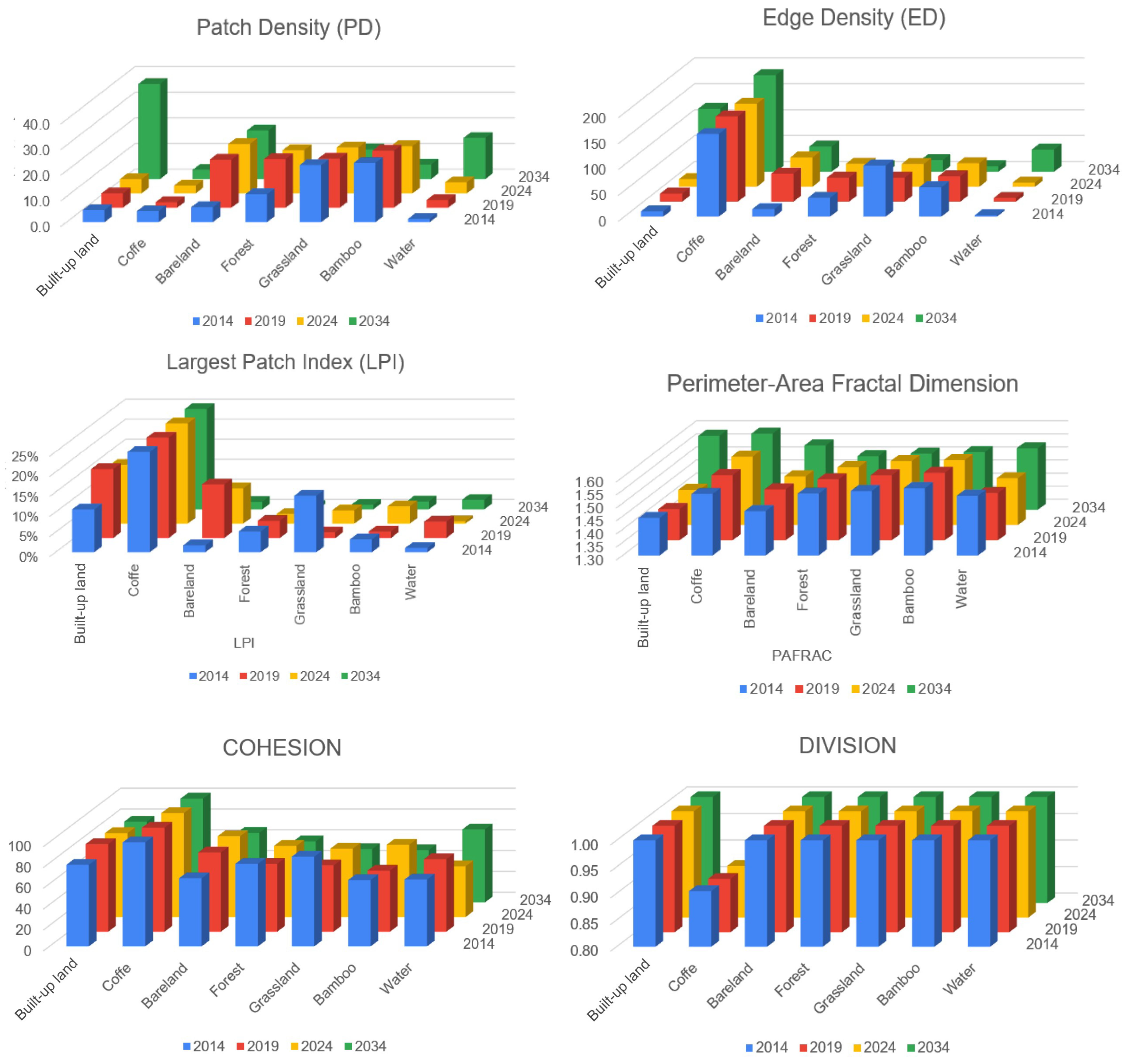
Selection and Calculation of Landscape Pattern Indices
3. Results
3.1. Spatiotemporal Analysis of LULC Changes in the CCLC
3.1.1. LULC Classification and Validation
3.1.2. Characteristic Analysis of LULC Structure (2014–2024)
3.2. LULC Prediction for 2034
3.3. LULC Changes 2014–2034
3.3.1. Land Use Transfer Analysis
3.3.2. Analysis of the Comprehensive Land Use Degree
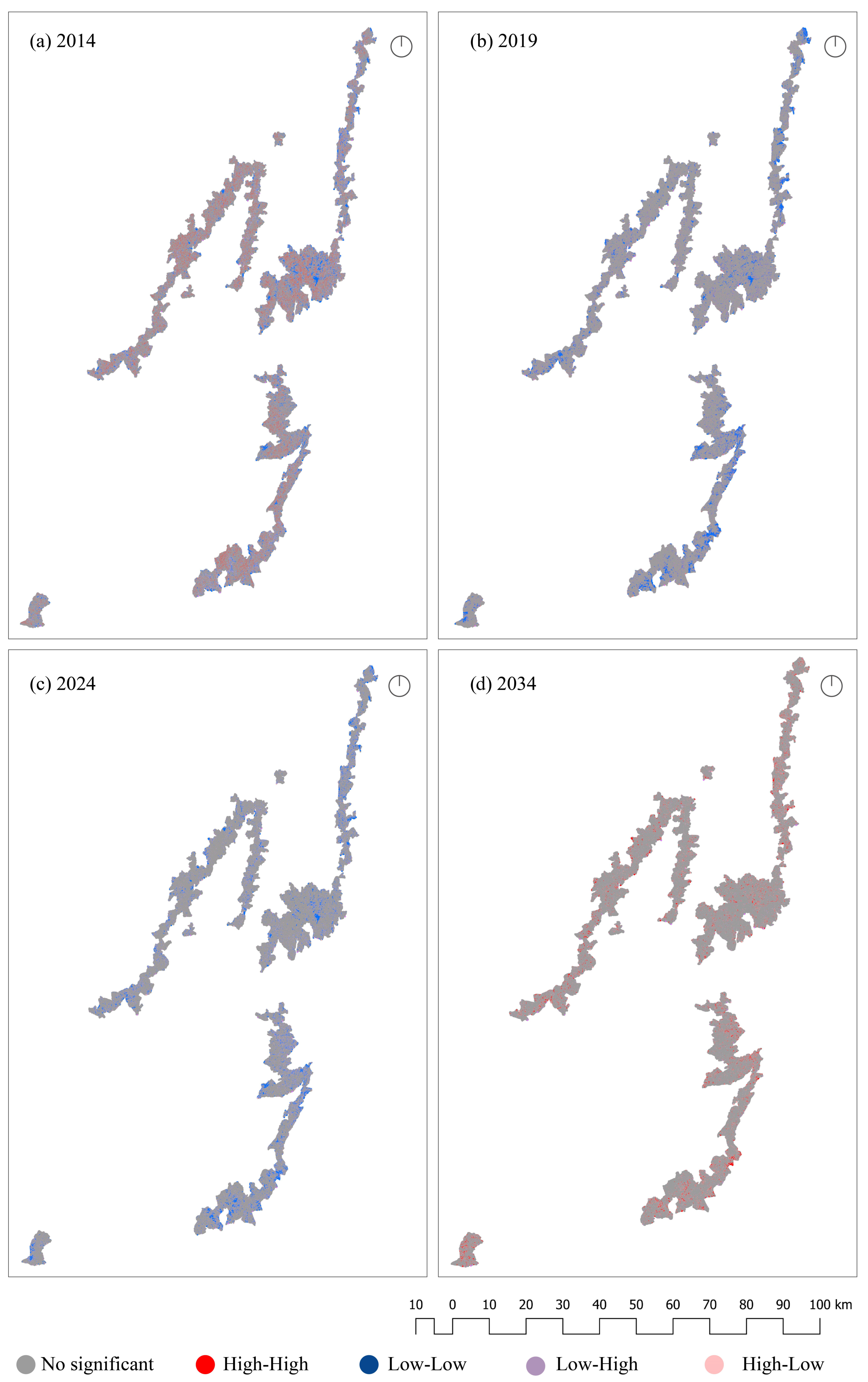
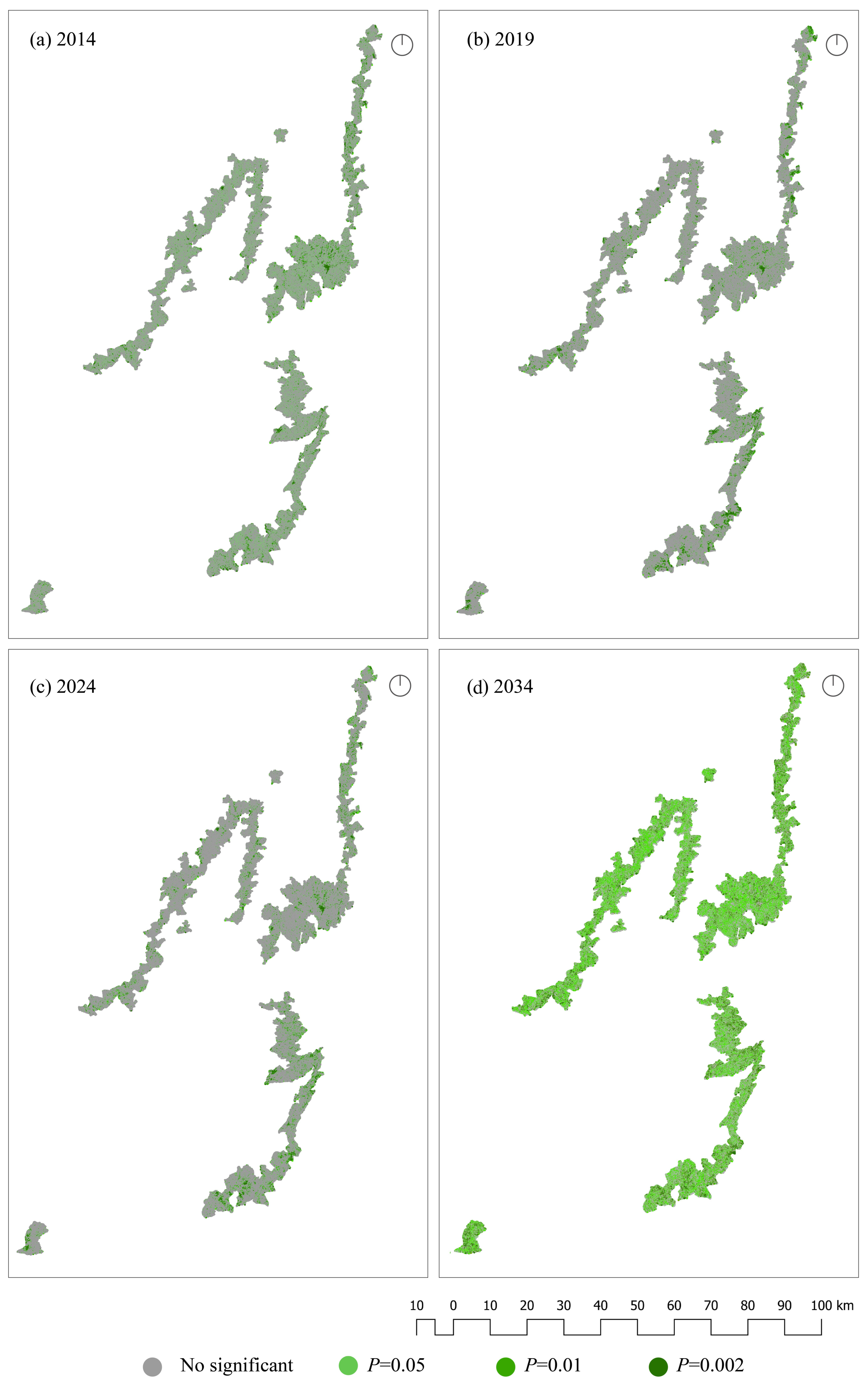
3.4. Spatial Autocorrelation Analysis of LUDI
3.4.1. Global Autocorrelation Analysis
3.4.2. Local Autocorrelation Analysis
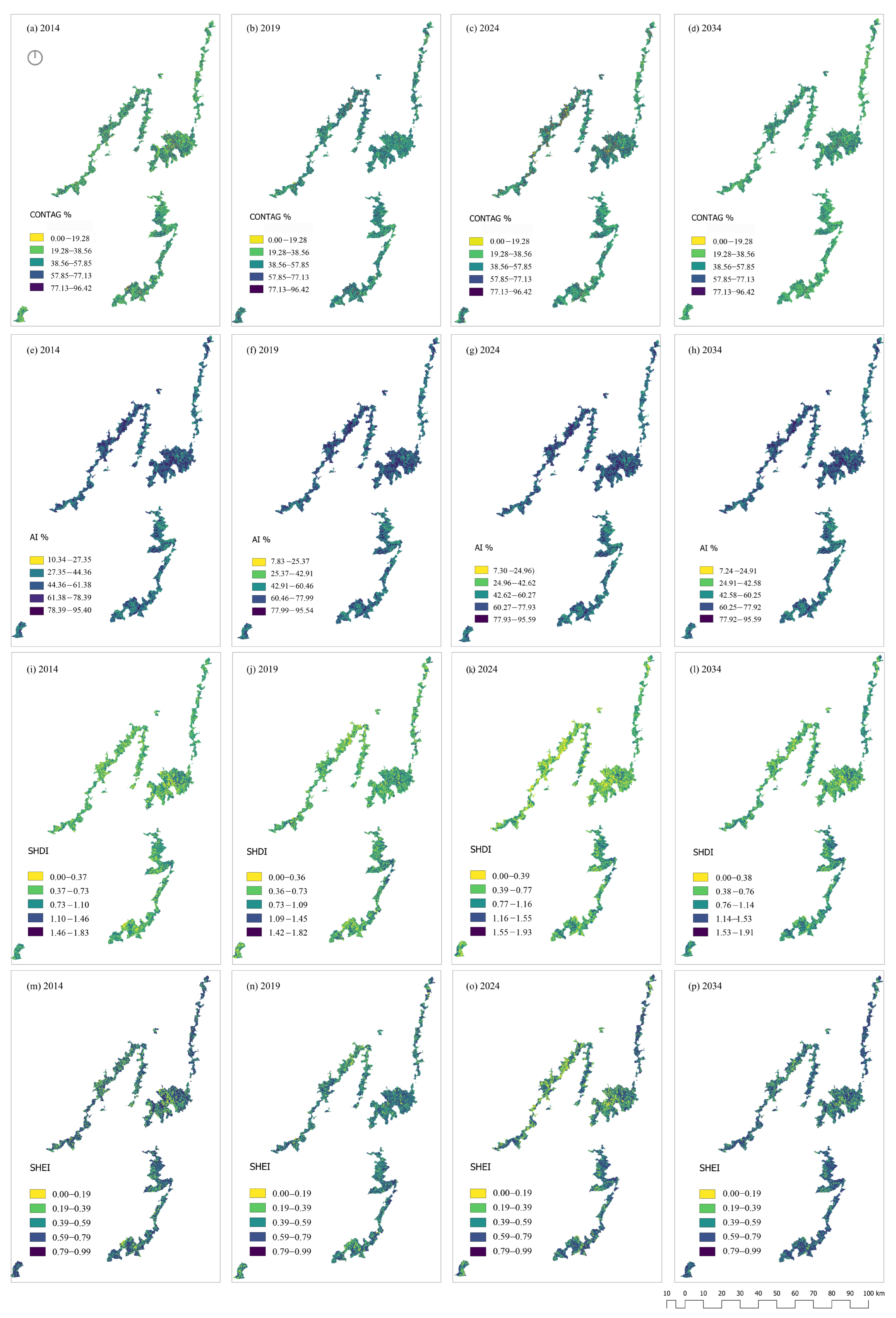
3.5. Spatiotemporal Characteristics of Landscape Patterns
4. Discussion
4.1. Land Use and Land Cover Transformations
4.2. Ecological Fragmentation and Spatial Landscape Patterns
4.3. Persistence of the Coffee Landscape and Resilience Processes
4.4. Study Limitations and Future Research Directions
5. Conclusions
Supplementary Materials
Author Contributions
Funding
Informed Consent Statement
Data Availability Statement
Acknowledgments
Conflicts of Interest
Appendix A
Appendix B

| Scale | Index and Equation | Variable Declaration | Meaning |
|---|---|---|---|
| Class metrics | PD: Patch density N is the number of patches A is the area of a certain type of landscape | PD reflects the degree of landscape fragmentation within a certain area. The greater the patch density, the greater the degree of fragmentation. | |
| ED: Edge density Pᵢⱼ: Edge length between patch i and patch j M: Total number of patch classes in the landscape A: Total landscape area | ED reflects the edge length between the patches of heterogeneous landscape elements per unit area within a certain regional landscape scope. | ||
| LPI: Largest Patch Index max (aᵢ): Area of the largest patch in class i A: Total landscape area ×100: converts the result to a percentage | LPI is the percentage of the largest patch area in the total landscape area, and is a measure of the dominance degree at the patch level. | ||
| Pij: Perimeter of patch ij aij: Area of patch ij A: Total landscape area | PAFRAC reflects the degree of disturbance from human activities in the landscape pattern, but the formula should be carefully verified for accuracy. | ||
| Pi: Perimeter of patch i Ai: Area of patch I A: Total landscape area n: Total number of patches in the class or landscape | COHESION reflects the aggregation and dispersion of landscape elements. | ||
| Landscape metrics | aij: Area of patch ij A: Total landscape area n: Total number of patches | DIVISION reflects the degree of fragmentation of patches within the region. | |
| gii: Number of like adjacencies between pixels of class I giimax: Maximum possible number of like adjacencies for class i | AI reflects the degree of patch aggregation in the landscape. A higher value indicates greater aggregation. | ||
| Pij: Proportion of adjacencies between patch types i and j m: Total number of patch types (classes) in the landscape ∑Pij: Total number of pairwise adjacencies in the landscape | CONTAG measures the degree of aggregation of different patch types in a given area. A higher value indicates greater aggregation. | ||
| Pi: Proportion of the landscape occupied by patch type I m: Total number of patch types in the landscape ln: Natural logarithm | SHDI reflects the diversity of landscape elements in a given area. A higher value indicates greater diversity. | ||
| SHEI: Shannon’s Evenness Index SHDI: Shannon Diversity Index m: Total number of patch types in the landscape | SHEI measures the evenness in the distribution of patch types. A higher value indicates a more even distribution. |
References
- Badman, T.; Bomhard, B.; Fincke, A.; Langley, J.; Rosabal, P.; Sheppard, D. Outstanding Universal Value: Standards for Natural World Heritage; IUCN: Gland, Switzerland, 2008. [Google Scholar]
- Guo, H.; Chen, F.; Tang, Y.; Ding, Y.; Chen, M.; Zhou, W.; Zhu, M.; Gao, S.; Yang, R.; Zheng, W.; et al. Progress toward the Sustainable Development of World Cultural Heritage Sites Facing Land-Cover Changes. Innovation 2023, 4, 100496. [Google Scholar] [CrossRef] [PubMed]
- Winkler, K.; Fuchs, R.; Rounsevell, M.; Herold, M. Global Land Use Changes Are Four Times Greater than Previously Estimated. Nat. Commun. 2021, 12, 2501. [Google Scholar] [CrossRef] [PubMed]
- He, D.; Chen, W.; Zhang, J. Integrating Heritage and Environment: Characterization of Cultural Landscape in Beijing Great Wall Heritage Area. Land 2024, 13, 536. [Google Scholar] [CrossRef]
- Venter, O.; Sanderson, E.W.; Magrach, A.; Allan, J.R.; Beher, J.; Jones, K.R.; Possingham, H.P.; Laurance, W.F.; Wood, P.; Fekete, B.M.; et al. Sixteen Years of Change in the Global Terrestrial Human Footprint and Implications for Biodiversity Conservation. Nat. Commun. 2016, 7, 12558. [Google Scholar] [CrossRef]
- Garrard, R.; Kohler, T.; Price, M.F.; Byers, A.C.; Sherpa, A.R.; Maharjan, G.R. Land Use and Land Cover Change in Sagarmatha National Park, a World Heritage Site in the Himalayas of Eastern Nepal. Mt. Res. Dev. 2016, 36, 299. [Google Scholar] [CrossRef]
- Kim, J.; Choi, H.; Shin, W.; Yun, J.; Song, Y. Complex Spatiotemporal Changes in Land-Use and Ecosystem Services in the Jeju Island UNESCO Heritage and Biosphere Site (Republic of Korea). Environ. Conserv. 2022, 49, 272–279. [Google Scholar] [CrossRef]
- Remond-Noa, R.; González-Sousa, R.; Cámara-García, F.L.; Cabrera, N.; Quintana-Cortina, C.; Martínez-Murillo, J.F. Modelling Land Use Changes and Impacts on the Visual Fragility of a UNESCO Landscape Heritage Site (Viñales, Cuba). In Mapping and Forecasting Land Use; Elsevier: Amsterdam, The Netherlands, 2022; pp. 265–297. ISBN 978-0-323-90947-1. [Google Scholar]
- Lambin, E.F.; Geist, H.J.; Lepers, E. Dynamics of Land-Use and Land-Cover Change in Tropical Regions. Annu. Rev. Environ. Resour. 2003, 28, 205–241. [Google Scholar] [CrossRef]
- Palang, H.; Soini, K.; Printsmann, A.; Birkeland, I. Landscape and Cultural Sustainability. Nor. Geogr. Tidsskr. Nor. J. Geogr. 2017, 71, 127–131. [Google Scholar] [CrossRef]
- Zimmermann, P.; Tasser, E.; Leitinger, G.; Tappeiner, U. Effects of Land-Use and Land-Cover Pattern on Landscape-Scale Biodiversity in the European Alps. Agric. Ecosyst. Environ. 2010, 139, 13–22. [Google Scholar] [CrossRef]
- Zhao, Q.; Wen, Z.; Chen, S.; Ding, S.; Zhang, M. Quantifying Land Use/Land Cover and Landscape Pattern Changes and Impacts on Ecosystem Services. Int. J. Environ. Res. Public Health 2020, 17, 126. [Google Scholar] [CrossRef]
- Foley, J.A.; DeFries, R.; Asner, G.P.; Barford, C.; Bonan, G.; Carpenter, S.R.; Chapin, F.S.; Coe, M.T.; Daily, G.C.; Gibbs, H.K.; et al. Global Consequences of Land Use. Science 2005, 309, 570–574. [Google Scholar] [CrossRef]
- Medeiros, A.; Fernandes, C.; Gonçalves, J.F.; Farinha-Marques, P. A Diagnostic Framework for Assessing Land-Use Change Impacts on Landscape Pattern and Character—A Case-Study from the Douro Region, Portugal. Landsc. Urban Plan. 2022, 228, 104580. [Google Scholar] [CrossRef]
- Li, X.; Yeh, A.G.-O. Analyzing Spatial Restructuring of Land Use Patterns in a Fast Growing Region Using Remote Sensing and GIS. Landsc. Urban Plan. 2004, 69, 335–354. [Google Scholar] [CrossRef]
- Ren, S.; Zhao, H.; Zhang, H.; Wang, F.; Yang, H. Influence of Natural and Social Economic Factors on Landscape Pattern Indices—The Case of the Yellow River Basin in Henan Province. Water 2023, 15, 4174. [Google Scholar] [CrossRef]
- Demessie, S.F.; Dile, Y.T.; Bedadi, B.; Tarkegn, T.G.; Bayabil, H.K.; Sintayehu, D.W. Assessing and Projecting Land Use Land Cover Changes Using Machine Learning Models in the Guder Watershed, Ethiopia. Environ. Chall. 2025, 18, 101074. [Google Scholar] [CrossRef]
- Murillo-López, B.E.; Feijoo-Martínez, A.; Carvajal, A.F. Land Cover Changes in Coffee Cultural Landscapes of Pereira (Colombia) between 1997 and 2014. Cuad. Investig. Geogr. 2022, 48, 175–196. [Google Scholar] [CrossRef]
- Wang, Q.; Bai, X. Spatiotemporal Characteristics and Driving Mechanisms of Land-Use Transitions and Landscape Patterns in Response to Ecological Restoration Projects: A Case Study of Mountainous Areas in Guizhou, Southwest China. Ecol. Inform. 2024, 82, 102748. [Google Scholar] [CrossRef]
- Wang, Q.; Wang, H. Spatiotemporal Dynamics and Evolution Relationships between Land-Use/Land Cover Change and Landscape Pattern in Response to Rapid Urban Sprawl Process: A Case Study in Wuhan, China. Ecol. Eng. 2022, 182, 106716. [Google Scholar] [CrossRef]
- Chaves, M.E.D.; Picoli, M.C.A.; Sanches, I.D. Recent Applications of Landsat 8/OLI and Sentinel-2/MSI for Land Use and Land Cover Mapping: A Systematic Review. Remote Sens. 2020, 12, 3062. [Google Scholar] [CrossRef]
- Hunt, D.A.; Tabor, K.; Hewson, J.H.; Wood, M.A.; Reymondin, L.; Koenig, K.; Schmitt-Harsh, M.; Follett, F. Review of Remote Sensing Methods to Map Coffee Production Systems. Remote Sens. 2020, 12, 2041. [Google Scholar] [CrossRef]
- Kamaraj, M.; Rangarajan, S. Predicting the Future Land Use and Land Cover Changes for Bhavani Basin, Tamil Nadu, India Using QGIS MOLUSCE Plugin. Environ. Sci. Pollut. Res. 2021, 29, 86337–86348. [Google Scholar] [CrossRef] [PubMed]
- Cruz-Rincón, D.F. Transformaciones, Contradicciones y Paradojas Del Paisaje Cultural Cafetero de Colombia: Una Revisión de Literatura. Soc. Econ. 2024, 51, e10112226. [Google Scholar] [CrossRef]
- Coffee Cultural Landscape of Colombia—UNESCO World Heritage Centre. Available online: https://whc.unesco.org/en/list/1121 (accessed on 6 February 2025).
- Velandia Silva, C.; Arango, G.; Rivas, L.; Castañeda-Pérez, Y. Paisaje Cultural Cafetero: Excepcional Fusión Entre Naturaleza, Cultura y Trabajo Colectivo. (Editor) Versión Abreviada y Actualizada 2016; Federación Nacional de Cafeteros de Colombia: Armenia, Colombia, 2016; ISBN 978-958-56007-0-6. [Google Scholar]
- Etter, A.; McAlpine, C.; Wilson, K.; Phinn, S.; Possingham, H. Regional Patterns of Agricultural Land Use and Deforestation in Colombia. Agric. Ecosyst. Environ. 2006, 114, 369–386. [Google Scholar] [CrossRef]
- Cifuentes Monsalve, D.M.; Duque Arango, G.I. La Transformación Del Paisaje Urbano Rural Del Municipio de Montenegro, Quindío. MÓDULO Arquit. CUC 2021, 26, 191–216. [Google Scholar] [CrossRef]
- Murillo-López, B.E.; Castro, A.J.; Feijoo-Martínez, A. Nature’s Contributions to People Shape Sense of Place in the Coffee Cultural Landscape of Colombia. Agriculture 2022, 12, 457. [Google Scholar] [CrossRef]
- UNESCO World Heritage Centre. Note 1—Identifying and Mapping Attributes That Convey the Outstanding Universal Value of a World Heritage Property. Available online: https://whc.unesco.org/en/wind-energy/note1/ (accessed on 8 April 2025).
- UNESCO World Heritage Centre—Compendium. Available online: https://whc.unesco.org/en/compendium/?action=list&id_faq_themes=972,1526,1528,1530,1532 (accessed on 8 April 2025).
- UNESCO World Heritage Centre. Buffer Zones—Glossary. Available online: https://whc.unesco.org/en/glossary/199 (accessed on 8 April 2025).
- Inglada, J.; Vincent, A.; Arias, M.; Marais-Sicre, C. Improved Early Crop Type Identification By Joint Use of High Temporal Resolution SAR And Optical Image Time Series. Remote Sens. 2016, 8, 362. [Google Scholar] [CrossRef]
- Kussul, N.; Lemoine, G.; Gallego, F.J.; Skakun, S.V.; Lavreniuk, M.; Shelestov, A.Y. Parcel-Based Crop Classification in Ukraine Using Landsat-8 Data and Sentinel-1A Data. IEEE J. Sel. Top. Appl. Earth Obs. Remote Sens. 2016, 9, 2500–2508. [Google Scholar] [CrossRef]
- DeVries, B.; Huang, C.; Armston, J.; Huang, W.; Jones, J.W.; Lang, M.W. Rapid and Robust Monitoring of Flood Events Using Sentinel-1 and Landsat Data on the Google Earth Engine. Remote Sens. Environ. 2020, 240, 111664. [Google Scholar] [CrossRef]
- Chander, G.; Markham, B.L.; Helder, D.L. Summary of Current Radiometric Calibration Coefficients for Landsat MSS, TM, ETM+, and EO-1 ALI Sensors. Remote Sens. Environ. 2009, 113, 893–903. [Google Scholar] [CrossRef]
- Automated cloud, cloud shadow, and snow detection in multitemporal Landsat data: An algorithm designed specifically for monitoring land cover change. Remote Sens. Environ. 2014, 152, 217–234. [CrossRef]
- Mateo-García, G.; Gómez-Chova, L.; Amorós-López, J.; Muñoz-Marí, J.; Camps-Valls, G. Multitemporal Cloud Masking in the Google Earth Engine. Remote Sens. 2018, 10, 1079. [Google Scholar] [CrossRef]
- Gorelick, N.; Hancher, M.; Dixon, M.; Ilyushchenko, S.; Thau, D.; Moore, R. Google Earth Engine: Planetary-Scale Geospatial Analysis for Everyone. Remote Sens. Environ. 2017, 202, 18–27. [Google Scholar] [CrossRef]
- Dos Santos, E.P.; Da Silva, D.D.; Do Amaral, C.H.; Fernandes-Filho, E.I.; Dias, R.L.S. A Machine Learning Approach to Reconstruct Cloudy Affected Vegetation Indices Imagery via Data Fusion from Sentinel-1 and Landsat 8. Comput. Electron. Agric. 2022, 194, 106753. [Google Scholar] [CrossRef]
- Zhang, Z.; Wei, M.; Pu, D.; He, G.; Wang, G.; Long, T. Assessment of Annual Composite Images Obtained by Google Earth Engine for Urban Areas Mapping Using Random Forest. Remote Sens. 2021, 13, 748. [Google Scholar] [CrossRef]
- White, J.C.; Wulder, M.A.; Hobart, G.W.; Luther, J.E.; Hermosilla, T.; Griffiths, P.; Coops, N.C.; Hall, R.J.; Hostert, P.; Dyk, A.; et al. Pixel-Based Image Compositing for Large-Area Dense Time Series Applications and Science. Can. J. Remote Sens. 2014, 40, 192–212. [Google Scholar] [CrossRef]
- Torres, R.; Snoeij, P.; Geudtner, D.; Bibby, D.; Davidson, M.; Attema, E.; Potin, P.; Rommen, B.; Floury, N.; Brown, M.; et al. GMES Sentinel-1 Mission. Remote Sens. Environ. 2012, 120, 9–24. [Google Scholar] [CrossRef]
- Dostálová, A.; Hollaus, M.; Milenković, M.; Wagner, W. FOREST AREA DERIVATION FROM SENTINEL-1 DATA. ISPRS Ann. Photogramm. Remote Sens. Spat. Inf. Sci. 2016, III–7, 227–233. [Google Scholar] [CrossRef]
- Sánchez-Méndez, A.G.; Arguijo-Hernández, S.P. Análisis de imágenes multiespectrales para la detección de cultivos y detección de plagas y enfermedades en la producción de café. Res. Comput. Sci. 2018, 147, 309–317. [Google Scholar] [CrossRef]
- Chemura, A.; Mutanga, O.; Dube, T. Integrating Age in the Detection and Mapping of Incongruous Patches in Coffee (Coffea Arabica) Plantations Using Multi-Temporal Landsat 8 NDVI Anomalies. Int. J. Appl. Earth Obs. Geoinform. 2017, 57, 1–13. [Google Scholar] [CrossRef]
- Roy, D.P.; Wulder, M.A.; Loveland, T.R.; Woodcock, C.E.; Allen, R.G.; Anderson, M.C.; Helder, D.; Irons, J.R.; Johnson, D.M.; Kennedy, R.; et al. Landsat-8: Science and Product Vision for Terrestrial Global Change Research. Remote Sens. Environ. 2014, 145, 154–172. [Google Scholar] [CrossRef]
- Vermote, E.; Justice, C.; Claverie, M.; Franch, B. Preliminary Analysis of the Performance of the Landsat 8/OLI Land Surface Reflectance Product. Remote Sens. Environ. 2016, 185, 46–56. [Google Scholar] [CrossRef] [PubMed]
- Feng, X.; Tan, S.; Dong, Y.; Zhang, X.; Xu, J.; Zhong, L.; Yu, L. Mapping Large-Scale Bamboo Forest Based on Phenology and Morphology Features. Remote Sens. 2023, 15, 515. [Google Scholar] [CrossRef]
- Fang, G.; Xu, H.; Yang, S.-I.; Lou, X.; Fang, L. Synergistic Use of Sentinel-1, Sentinel-2, and Landsat 8 in Predicting Forest Variables. Ecol. Indic. 2023, 151, 110296. [Google Scholar] [CrossRef]
- Jiang, Z.; Huete, A.; Didan, K.; Miura, T. Development of a Two-Band Enhanced Vegetation Index without a Blue Band. Remote Sens. Environ. 2008, 112, 3833–3845. [Google Scholar] [CrossRef]
- Saleska, S.R.; Wu, J.; Guan, K.; Araujo, A.C.; Huete, A.; Nobre, A.D.; Restrepo-Coupe, N. Dry-Season Greening of Amazon Forests. Nature 2016, 531, E4–E5. [Google Scholar] [CrossRef]
- Huete, A.R. A Soil-Adjusted Vegetation Index (SAVI). Remote Sens. Environ. 1988, 25, 295–309. [Google Scholar] [CrossRef]
- Escobar-López, A.; Castillo-Santiago, M.Á.; Mas, J.F.; Hernández-Stefanoni, J.L.; López-Martínez, J.O. Identification of Coffee Agroforestry Systems Using Remote Sensing Data: A Review of Methods and Sensor Data. Geocarto Int. 2024, 39, 2297555. [Google Scholar] [CrossRef]
- Ke, Y.; Im, J.; Lee, J.; Gong, H.; Ryu, Y. Characteristics of Landsat 8 OLI-Derived NDVI by Comparison with Multiple Satellite Sensors and in-Situ Observations. Remote Sens. Environ. 2015, 164, 298–313. [Google Scholar] [CrossRef]
- Wang, C.; Qi, S.; Niu, Z.; Wang, J. Evaluating Soil Moisture Status in China Using the Temperature–Vegetation Dryness Index (TVDI). Can. J. Remote Sens. 2004, 30, 671–679. [Google Scholar] [CrossRef]
- Susan Moran, M. Soil Moisture Evaluation Using Multi-Temporal Synthetic Aperture Radar (SAR) in Semiarid Rangeland. Agric. For. Meteorol. 2000, 105, 69–80. [Google Scholar] [CrossRef]
- Yang, Y.; Guan, H.; Long, D.; Liu, B.; Qin, G.; Qin, J.; Batelaan, O. Estimation of Surface Soil Moisture from Thermal Infrared Remote Sensing Using an Improved Trapezoid Method. Remote Sens. 2015, 7, 8250–8270. [Google Scholar] [CrossRef]
- Zha, Y.; Gao, J.; Ni, S. Use of Normalized Difference Built-up Index in Automatically Mapping Urban Areas from TM Imagery. Int. J. Remote Sens. 2003, 24, 583–594. [Google Scholar] [CrossRef]
- Muhaimin, M.; Fitriani, D.; Adyatma, S.; Arisanty, D. Mapping Build-up Area Density Using Normalized Difference Built-up Index (Ndbi) and Urban Index (Ui) Wetland in the City Banjarmasin. IOP Conf. Ser. Earth Environ. Sci. 2022, 1089, 012036. [Google Scholar] [CrossRef]
- Kawamura, M.; Jayamana, S.; Tsujiko, Y. Relation between Social and Environmental Conditions in Colombo Sri Lanka and the Urban Index Estimated by Satellite Remote Sensing Data. Int. Arch. Photogramm. Remote Sens. 1996, 31 (Pt B7), 321–326. [Google Scholar]
- Zhou, Y.; Yang, G.; Wang, S.; Wang, L.; Wang, F.; Liu, X. A New Index for Mapping Built-up and Bare Land Areas from Landsat-8 OLI Data. Remote Sens. Lett. 2014, 5, 862–871. [Google Scholar] [CrossRef]
- He, C.; Liu, Z.; Gou, S.; Zhang, Q.; Zhang, J.; Xu, L. Detecting Global Urban Expansion over the Last Three Decades Using a Fully Convolutional Network. Environ. Res. Lett. 2019, 14, 034008. [Google Scholar] [CrossRef]
- Diek, S.; Fornallaz, F.; Schaepman, M.E.; De Jong, R. Barest Pixel Composite for Agricultural Areas Using Landsat Time Series. Remote Sens. 2017, 9, 1245. [Google Scholar] [CrossRef]
- Wang, L.; Qu, J.J. Satellite Remote Sensing Applications for Surface Soil Moisture Monitoring: A Review. Front. Earth Sci. China 2009, 3, 237–247. [Google Scholar] [CrossRef]
- Xu, H. Modification of Normalised Difference Water Index (NDWI) to Enhance Open Water Features in Remotely Sensed Imagery. Int. J. Remote Sens. 2006, 27, 3025–3033. [Google Scholar] [CrossRef]
- Gao, B. NDWI—A Normalized Difference Water Index for Remote Sensing of Vegetation Liquid Water from Space. Remote Sens. Environ. 1996, 58, 257–266. [Google Scholar] [CrossRef]
- McFeeters, S.K. The Use of the Normalized Difference Water Index (NDWI) in the Delineation of Open Water Features. Int. J. Remote Sens. 1996, 17, 1425–1432. [Google Scholar] [CrossRef]
- Du, Y.; Zhang, Y.; Ling, F.; Wang, Q.; Li, W.; Li, X. Water Bodies’ Mapping from Sentinel-2 Imagery with Modified Normalized Difference Water Index at 10-m Spatial Resolution Produced by Sharpening the SWIR Band. Remote Sens. 2016, 8, 354. [Google Scholar] [CrossRef]
- Chandrasekar, K.; Sesha Sai, M.V.R.; Roy, P.S.; Dwevedi, R.S. Land Surface Water Index (LSWI) Response to Rainfall and NDVI Using the MODIS Vegetation Index Product. Int. J. Remote Sens. 2010, 31, 3987–4005. [Google Scholar] [CrossRef]
- Zhu, X.; Chen, J.; Gao, F.; Chen, X.; Masek, J.G. An Enhanced Spatial and Temporal Adaptive Reflectance Fusion Model for Complex Heterogeneous Regions. Remote Sens. Environ. 2010, 114, 2610–2623. [Google Scholar] [CrossRef]
- Congalton, R.G.; Green, K. Assessing the Accuracy of Remotely Sensed Data: Principles and Practices, 2nd ed.; CRC Press: Boca Raton, FL, USA, 2008; ISBN 978-0-429-14397-7. [Google Scholar]
- Shafizadeh-Moghadam, H.; Minaei, M.; Pontius, R.G., Jr.; Asghari, A.; Dadashpoor, H. Integrating a Forward Feature Selection Algorithm, Random Forest, and Cellular Automata to Extrapolate Urban Growth in the Tehran-Karaj Region of Iran. Comput. Environ. Urban Syst. 2021, 87, 101595. [Google Scholar] [CrossRef]
- Liu, Y.; Wang, Y.; Zhang, J. New Machine Learning Algorithm: Random Forest. In Proceedings of the Information Computing and Applications; Liu, B., Ma, M., Chang, J., Eds.; Springer: Berlin/Heidelberg, Germany, 2012; pp. 246–252. [Google Scholar]
- Sun, Z.; Wang, G.; Li, P.; Wang, H.; Zhang, M.; Liang, X. An Improved Random Forest Based on the Classification Accuracy and Correlation Measurement of Decision Trees. Expert Syst. Appl. 2024, 237, 121549. [Google Scholar] [CrossRef]
- Abbas, Z.; Jaber, H.S. Accuracy Assessment of Supervised Classification Methods for Extraction Land Use Maps Using Remote Sensing and GIS Techniques. IOP Conf. Ser. Mater. Sci. Eng. 2020, 745, 012166. [Google Scholar] [CrossRef]
- Amini, S.; Saber, M.; Rabiei-Dastjerdi, H.; Homayouni, S. Urban Land Use and Land Cover Change Analysis Using Random Forest Classification of Landsat Time Series. Remote Sens. 2022, 14, 2654. [Google Scholar] [CrossRef]
- Breiman, L. Random Forests. Mach. Learn. 2001, 45, 5–32. [Google Scholar] [CrossRef]
- Rodriguez-Galiano, V.F.; Ghimire, B.; Rogan, J.; Chica-Olmo, M.; Rigol-Sanchez, J.P. An Assessment of the Effectiveness of a Random Forest Classifier for Land-Cover Classification. ISPRS J. Photogramm. Remote Sens. 2012, 67, 93–104. [Google Scholar] [CrossRef]
- Olofsson, P.; Foody, G.M.; Herold, M.; Stehman, S.V.; Woodcock, C.E.; Wulder, M.A. Good Practices for Estimating Area and Assessing Accuracy of Land Change. Remote Sens. Environ. 2014, 148, 42–57. [Google Scholar] [CrossRef]
- Foody, G.M. Status of Land Cover Classification Accuracy Assessment. Remote Sens. Environ. 2002, 80, 185–201. [Google Scholar] [CrossRef]
- Pontius, R.G.; Millones, M. Death to Kappa: Birth of Quantity Disagreement and Allocation Disagreement for Accuracy Assessment. Int. J. Remote Sens. 2011, 32, 4407–4429. [Google Scholar] [CrossRef]
- Stehman, S.V.; Foody, G.M. Key Issues in Rigorous Accuracy Assessment of Land Cover Products. Remote Sens. Environ. 2019, 231, 111199. [Google Scholar] [CrossRef]
- Feizizadeh, B.; Darabi, S.; Blaschke, T.; Lakes, T. QADI as a New Method and Alternative to Kappa for Accuracy Assessment of Remote Sensing-Based Image Classification. Sensors 2022, 22, 4506. [Google Scholar] [CrossRef] [PubMed]
- Farr, T.G.; Rosen, P.A.; Caro, E.; Crippen, R.; Duren, R.; Hensley, S.; Kobrick, M.; Paller, M.; Rodriguez, E.; Roth, L.; et al. The Shuttle Radar Topography Mission. Rev. Geophys. 2007, 45, 2005RG000183. [Google Scholar] [CrossRef]
- Funk, C.; Peterson, P.; Landsfeld, M.; Pedreros, D.; Verdin, J.; Shukla, S.; Husak, G.; Rowland, J.; Harrison, L.; Hoell, A.; et al. The Climate Hazards Infrared Precipitation with Stations—A New Environmental Record for Monitoring Extremes. Sci. Data 2015, 2, 150066. [Google Scholar] [CrossRef]
- Copernicus Climate Change Service ERA5-Land Monthly Averaged Data from 1950 to Present 2019. Available online: https://cds.climate.copernicus.eu/datasets/reanalysis-era5-land-monthly-means?tab=overview (accessed on 16 April 2025).
- Lehner, B.; Verdin, K.; Jarvis, A. New Global Hydrography Derived From Spaceborne Elevation Data. Eos Trans. Am. Geophys. Union 2008, 89, 93–94. [Google Scholar] [CrossRef]
- Sorichetta, A.; Hornby, G.M.; Stevens, F.R.; Gaughan, A.E.; Linard, C.; Tatem, A.J. High-Resolution Gridded Population Datasets for Latin America and the Caribbean in 2010, 2015, and 2020. Sci. Data 2015, 2, 150045. [Google Scholar] [CrossRef]
- Muhammad, R.; Zhang, W.; Abbas, Z.; Guo, F.; Gwiazdzinski, L. Spatiotemporal Change Analysis and Prediction of Future Land Use and Land Cover Changes Using QGIS MOLUSCE Plugin and Remote Sensing Big Data: A Case Study of Linyi, China. Land 2022, 11, 419. [Google Scholar] [CrossRef]
- Baghel, S.; Kothari, M.K.; Tripathi, M.P.; Singh, P.K.; Bhakar, S.R.; Dave, V.; Jain, S.K. Spatiotemporal LULC Change Detection and Future Prediction for the Mand Catchment Using MOLUSCE Tool. Environ. Earth Sci. 2024, 83, 66. [Google Scholar] [CrossRef]
- Gao, C.; Cheng, D.; Iqbal, J.; Yao, S. Spatiotemporal Change Analysis and Prediction of the Great Yellow River Region (GYRR) Land Cover and the Relationship Analysis with Mountain Hazards. Land 2023, 12, 340. [Google Scholar] [CrossRef]
- Sahoo, S.; Sil, I.; Dhar, A.; Debsarkar, A.; Das, P.; Kar, A. Future Scenarios of Land-Use Suitability Modeling for Agricultural Sustainability in a River Basin. J. Clean. Prod. 2018, 205, 313–328. [Google Scholar] [CrossRef]
- Lewis, H.G.; Brown, M. A Generalized Confusion Matrix for Assessing Area Estimates from Remotely Sensed Data. Int. J. Remote Sens. 2001, 22, 3223–3235. [Google Scholar] [CrossRef]
- Ma, L.; Niu, S.; Yang, L.; Li, Y.; Li, Y. Dynamic Analysis of Land Use/Land Cover Change in Dunhuang Oasis, China. In Proceedings of the 2009 4th International Conference on Recent Advances in Space Technologies, Istanbul, Turkey, 11–13 June 2009; pp. 317–322. [Google Scholar]
- Munthali, M.; Botai, J.; Davis, N.; Abiodun, A. (PDF) Multi-Temporal Analysis of Land Use and Land Cover Change Detection for Dedza District of Malawi Using Geospatial Techniques. Available online: https://www.researchgate.net/publication/331979696_Multi-temporal_Analysis_of_Land_Use_and_Land_Cover_Change_Detection_for_Dedza_District_of_Malawi_using_Geospatial_Techniques (accessed on 4 March 2025).
- McGarigal, K.; Marks, B.J. FRAGSTATS: Spatial Pattern Analysis Program for Quantifying Landscape Structure.; U.S. Department of Agriculture, Forest Service, Pacific Northwest Research Station: Portland, OR, USA, 1995; p. PNW-GTR-351.
- McGarigal, K.; Cushman, S.A. The Gradient Concept of Landscape Structure. In Issues and Perspectives in Landscape Ecology; Wiens, J.A., Moss, M.R., Eds.; Cambridge University Press: Cambridge, UK, 2005; pp. 112–119. ISBN 978-0-521-53754-4. [Google Scholar]
- McGarigal, K.; Cushman, S.A.; Neel, M.C.; Ene, E. FRAGSTATS v4: Spatial Pattern Analysis Program for Categorical and Continuous Maps; University of Massachusetts, Amherst University of Massachusetts: Amherst, MA, USA, 2012. [Google Scholar]
- Zhuang, D.; Liu, J. Study on the Model of Regional Differentiationof Land Use Degree in China. J. Nat. Resour. 1997, 12, 105–111. [Google Scholar] [CrossRef]
- Anselin, L. Local Indicators of Spatial Association—LISA. Geogr. Anal. 1995, 27, 93–115. [Google Scholar] [CrossRef]
- Anselin, L. Quantile Local Spatial Autocorrelation. Lett. Spat. Resour. Sci. 2019, 12, 155–166. [Google Scholar] [CrossRef]
- Ord, J.K.; Getis, A. Testing for Local Spatial Autocorrelation in the Presence of Global Autocorrelation. J. Reg. Sci. 2001, 41, 411–432. [Google Scholar] [CrossRef]
- Li, X.; He, X.; Yang, G.; Liu, H.; Long, A.; Chen, F.; Liu, B.; Gu, X.; College of Water & Architectural Engineering, Shihezi University; Xinjiang Production & Construction Group Key Laboratory of Modern Water-Saving Irrigation; et al. Land Use/Cover and Landscape Pattern Changes in Manas River Basin Based on Remote Sensing. Int. J. Agric. Biol. Eng. 2020, 13, 141–152. [Google Scholar] [CrossRef]
- Yang, H.; Zhong, X.; Deng, S.; Nie, S. Impact of LUCC on Landscape Pattern in the Yangtze River Basin during 2001–2019. Ecol. Inform. 2022, 69, 101631. [Google Scholar] [CrossRef]
- Kubalikova, L.; Kirchner, K.; Kuda, F.; Machar, I. The Role of Anthropogenic Landforms in Sustainable Landscape Management. Sustainability 2019, 11, 4331. [Google Scholar] [CrossRef]
- Neumann, C.; Behling, R.; Weiss, G. Biodiversity Change in Cultural Landscapes—The Rural Hotspot Hypothesis. Ecol. Evol. 2025, 15, e70811. [Google Scholar] [CrossRef]
- Tang, Y.; Chen, F.; Yang, W.; Ding, Y.; Wan, H.; Sun, Z.; Jing, L. Elaborate Monitoring of Land-Cover Changes in Cultural Landscapes at Heritage Sites Using Very High-Resolution Remote-Sensing Images. Sustainability 2022, 14, 1319. [Google Scholar] [CrossRef]
- Observatorio para la Sostenibilidad del Patrimonio en Paisajes culturales Impactos Del Turismo En El Paisaje Cultural Cafetero: Caso de Estudio Filandia, Quindío (Contrato Interadministrativo No. 3977 de 2023). 2024. Available online: https://pcccomovamos.org/researches-impacto-turismo-pccc/#investigaciones (accessed on 18 April 2025).
- Modern zoning plans versus traditional landscape structures: Ecosystem service dynamics and interactions in rapidly urbanizing cultural landscapes. J. Environ. Manag. 2023, 331, 117315. [CrossRef] [PubMed]
- Keleg, M.; Watson, G.B.; Salheen, M.A. The Path to Resilience: Change, Landscape Aesthetics, and Socio-Cultural Identity in Rapidly Urbanising Contexts. The Case of Cairo, Egypt. Urban For. Urban Green. 2021, 65, 127360. [Google Scholar] [CrossRef]
- Estacio, I.; Basu, M.; Sianipar, C.P.M.; Onitsuka, K.; Hoshino, S. Dynamics of Land Cover Transitions and Agricultural Abandonment in a Mountainous Agricultural Landscape: Case of Ifugao Rice Terraces, Philippines. Landsc. Urban Plan. 2022, 222, 104394. [Google Scholar] [CrossRef]
- Franco-Solís, A.; Montanía, C.V. Dynamics of Deforestation Worldwide: A Structural Decomposition Analysis of Agricultural Land Use in South America. Land Use Policy 2021, 109, 105619. [Google Scholar] [CrossRef]
- Urte, D. Impactos del Turismo en el Paisaje Cultural Cafetero Filandia y Salento, Quindío y Salamina; Caldas Caso de Estudio: Salento, Quindío, Colombia, 2024. [Google Scholar]
- Fahrig, L.; Arroyo-Rodríguez, V.; Bennett, J.R.; Boucher-Lalonde, V.; Cazetta, E.; Currie, D.J.; Eigenbrod, F.; Ford, A.T.; Harrison, S.P.; Jaeger, J.A.G.; et al. Is Habitat Fragmentation Bad for Biodiversity? Biol. Conserv. 2019, 230, 179–186. [Google Scholar] [CrossRef]
- Fida, G.T.; Baatuuwie, B.N.; Issifu, H. Simulation of Land Use/Cover Dynamics in the Yayo Coffee Forest Biosphere Reserve, Southwestern Ethiopia. Geocarto Int. 2023, 38, 2256303. [Google Scholar] [CrossRef]
- UNESCO World Heritage Centre. Preparing World Heritage Nominations. Available online: https://whc.unesco.org/en/preparing-world-heritage-nominations/ (accessed on 13 April 2025).


| Data Sources for the LULC Classification 2014–2024 | |||||
|---|---|---|---|---|---|
| Dataset | Satellite Sensors | Spatial Resolution | Years | Bands | Band Descriptions |
| LANDSAT/LC08/C02/T1_L2 | Landsat 8 OLI | 30 m | 2014–2024 | SR_B2 (Blue) | Used for atmospheric correction and the analysis of water bodies and vegetation. |
| SR_B3 (Green) | Utilized for assessing vegetation health and agricultural applications. | ||||
| SR_B4 (Red) | Essential for calculating the Normalized Difference Vegetation Index (NDVI) and detecting soil changes. | ||||
| SR_B5 (NIR) | Crucial for evaluating biomass and vegetation vigor. | ||||
| SR_B6 (SWIR1) SR_B7 (SWIR2) | Used for detecting soil moisture and vegetation types, and for geological analysis. | ||||
| COPERNICUS/S1_GRD | Sentinel-1 SAR | 10 m reprojected to 30 m. The composite images were reprojected to the EPSG:4326 coordinate system at a 30 m scale, aligning with Landsat 8 optical images to facilitate multisensor integration. | 2014–2024 | VV (Vertical–Vertical) | Vertically transmitted and received polarization. Ideal for detecting vertical structures, dense vegetation, and soil moisture changes. Provides high sensitivity to geomorphological and surface properties. |
| VH (Vertical–Horizontal) | Vertically transmitted and horizontally received polarization. Effective for identifying horizontal features, soil heterogeneities, and linear structures. Complements the VV band by improving discrimination between different land cover types. | ||||
| Data Sources for the LULC Prediction (2024–2034) | |||||
| Data | Spatial Resolution | Source | |||
| Elevation | 30 m | NASA SRTM Digital Elevation Model (DEM) https://developers.google.com/earth-engine/datasets/catalog/USGS_SRTMGL1_003 (accessed on 8 November 2024) | |||
| Slope | Derived from DEM | ||||
| Aspect | 30 m | Derived from DEM | |||
| Precipitation | 30 m | Climate Hazards Center InfraRed Precipitation https://developers.google.com/earth-engine/datasets/catalog/UCSB-CHG_CHIRPS_DAILY (accessed on 16 April 2025) | |||
| Temperature | 30 m | ERA5-Land Daily Aggregated—ECMWF Climate Reanalysis https://developers.google.com/earth-engine/datasets/catalog/ECMWF_ERA5_LAND_DAILY_AGGR (accessed on 16 April 2025) | |||
| NDVI | 30 m | NDVI Composite https://developers.google.com/earth-engine/datasets/catalog/LANDSAT_COMPOSITES_C02_T1_L2_8DAY_NDVI (accessed on 16 April 2025) | |||
| Population | 30 m | WorldPop Global Project Population https://www.worldpop.org (accessed on 8 November 2024) | |||
| Distance to roads | 30 m | Calculated from the road network https://www.openstreetmap.org/#map=11/4.7623/-75.8263 (accessed on 8 November 2024) | |||
| Distance to rivers | 30 m | WWF/HydroSHEDS/15DIR15 https://developers.google.com/earth-engine/datasets/catalog/WWF_HydroSHEDS_15DIR (accessed on 8 November 2024) WWF/HydroSHEDS/15ACC https://developers.google.com/earth-engine/datasets/catalog/WWF_HydroSHEDS_15ACC#description (accessed on 8 November 2024) | |||
| ID | Class Name | Class Description |
|---|---|---|
| 0 | Built-up land | Areas occupied by built-up land and human-made structures, including rural dwellings and urban infrastructure such as residential, commercial, and industrial buildings. |
| 1 | Coffee crops | Areas dedicated to coffee cultivation, generally characterized by dense vegetation arranged in rows or terraces, common in agricultural coffee production zones. |
| 2 | Bareland | Areas with little or no vegetation, including exposed soils, rocks, sand, or eroded zones, typically of low fertility and with minimal use for agriculture or infrastructure. |
| 3 | Forests | Areas densely covered with trees and natural vegetation. |
| 4 | Grasslands | Areas primarily covered by grasslands, with low and sparse vegetation, often used for grazing or as natural buffer zones. |
| 5 | Bamboo | Zones dominated by bamboo plantations, a fast-growing plant that provides raw material for construction and handicrafts, while also serving as erosion protection in certain areas. |
| 6 | Water | Surfaces with permanent or temporary water accumulation on the land surface, including natural features (rivers, lakes, wetlands) and artificial elements (reservoirs, canals). |
| Land Use Type | Coffee Crops, Water | Forest, Bamboo | Bareland, Grasslands | Built-Up Land (Rural Residential Land, Urban Land) |
|---|---|---|---|---|
| Ld grade index | 1 | 2 | 3 | 4 |
| Year | 2014 | 2015 | 2016 | 2017 | 2018 | 2019 | 2020 | 2021 | 2022 | 2023 | 2024 | Average |
|---|---|---|---|---|---|---|---|---|---|---|---|---|
| OA (%) | 92.80 | 87.80 | 87.97 | 88.17 | 87.18 | 85.21 | 86.39 | 87.82 | 87.13 | 88.56 | 87.18 | 87.88 |
| Kappa | 0.91 | 0.84 | 0.84 | 0.85 | 0.84 | 0.81 | 0.83 | 0.84 | 0.83 | 0.85 | 0.83 | 0.84 |
| AD (%) | 5.02 | 5.89 | 9.07 | 6.77 | 8.60 | 10.50 | 8.46 | 9.39 | 7.15 | 6.33 | 7.89 | |
| QD (%) | 2.18 | 6.31 | 2.96 | 5.12 | 4.20 | 4.29 | 5.15 | 2.79 | 5.75 | 5.11 | 4.95 |
| LULC Classes | Area (2014) | Area (2019) | Area (2024) | Area (2034) | ||||
|---|---|---|---|---|---|---|---|---|
| ha | % | ha | % | ha | % | ha | % | |
| Built-up land | 2066.30 | 1.46 | 2567.72 | 1.77 | 3508.12 | 2.35 | 21,838.44 | 15.64 |
| Coffee | 96,855.25 | 69.38 | 108,298.52 | 77.91 | 101,601.42 | 72.89 | 95,447.55 | 68.40 |
| Bareland | 2558.99 | 1.83 | 5555.52 | 4.00 | 11,277.60 | 8.09 | 3261.00 | 2.33 |
| Forest | 6999.22 | 5.01 | 6537.58 | 4.70 | 7598.64 | 5.45 | 1553.79 | 1.11 |
| Grasslands | 21,934.85 | 15.71 | 5791.18 | 4.17 | 6998.83 | 5.02 | 8141.33 | 5.83 |
| Bamboo | 8787.77 | 6.30 | 9254.83 | 6.66 | 7452.90 | 5.35 | 7674.66 | 5.49 |
| Water | 421.09 | 0.30 | 1100.82 | 0.79 | 1185.96 | 0.85 | 1706.71 | 1.22 |
Disclaimer/Publisher’s Note: The statements, opinions and data contained in all publications are solely those of the individual author(s) and contributor(s) and not of MDPI and/or the editor(s). MDPI and/or the editor(s) disclaim responsibility for any injury to people or property resulting from any ideas, methods, instructions or products referred to in the content. |
© 2025 by the authors. Licensee MDPI, Basel, Switzerland. This article is an open access article distributed under the terms and conditions of the Creative Commons Attribution (CC BY) license (https://creativecommons.org/licenses/by/4.0/).
Share and Cite
Rojas Celis, A.P.; Shen, J.; Martinez Otalora, J.D. Spatiotemporal Land Use and Land Cover Changes and Their Impact on Landscape Patterns in the Colombian Coffee Cultural Landscape (2014–2034). Land 2025, 14, 1045. https://doi.org/10.3390/land14051045
Rojas Celis AP, Shen J, Martinez Otalora JD. Spatiotemporal Land Use and Land Cover Changes and Their Impact on Landscape Patterns in the Colombian Coffee Cultural Landscape (2014–2034). Land. 2025; 14(5):1045. https://doi.org/10.3390/land14051045
Chicago/Turabian StyleRojas Celis, Anyela Piedad, Jie Shen, and Jose David Martinez Otalora. 2025. "Spatiotemporal Land Use and Land Cover Changes and Their Impact on Landscape Patterns in the Colombian Coffee Cultural Landscape (2014–2034)" Land 14, no. 5: 1045. https://doi.org/10.3390/land14051045
APA StyleRojas Celis, A. P., Shen, J., & Martinez Otalora, J. D. (2025). Spatiotemporal Land Use and Land Cover Changes and Their Impact on Landscape Patterns in the Colombian Coffee Cultural Landscape (2014–2034). Land, 14(5), 1045. https://doi.org/10.3390/land14051045