
Multi-Hazard Assessment in Post-Mining Landscape and Potential for Geotourism Development (On the Example of the Central Spiš Region in Slovakia)


Abstract
1. Introduction
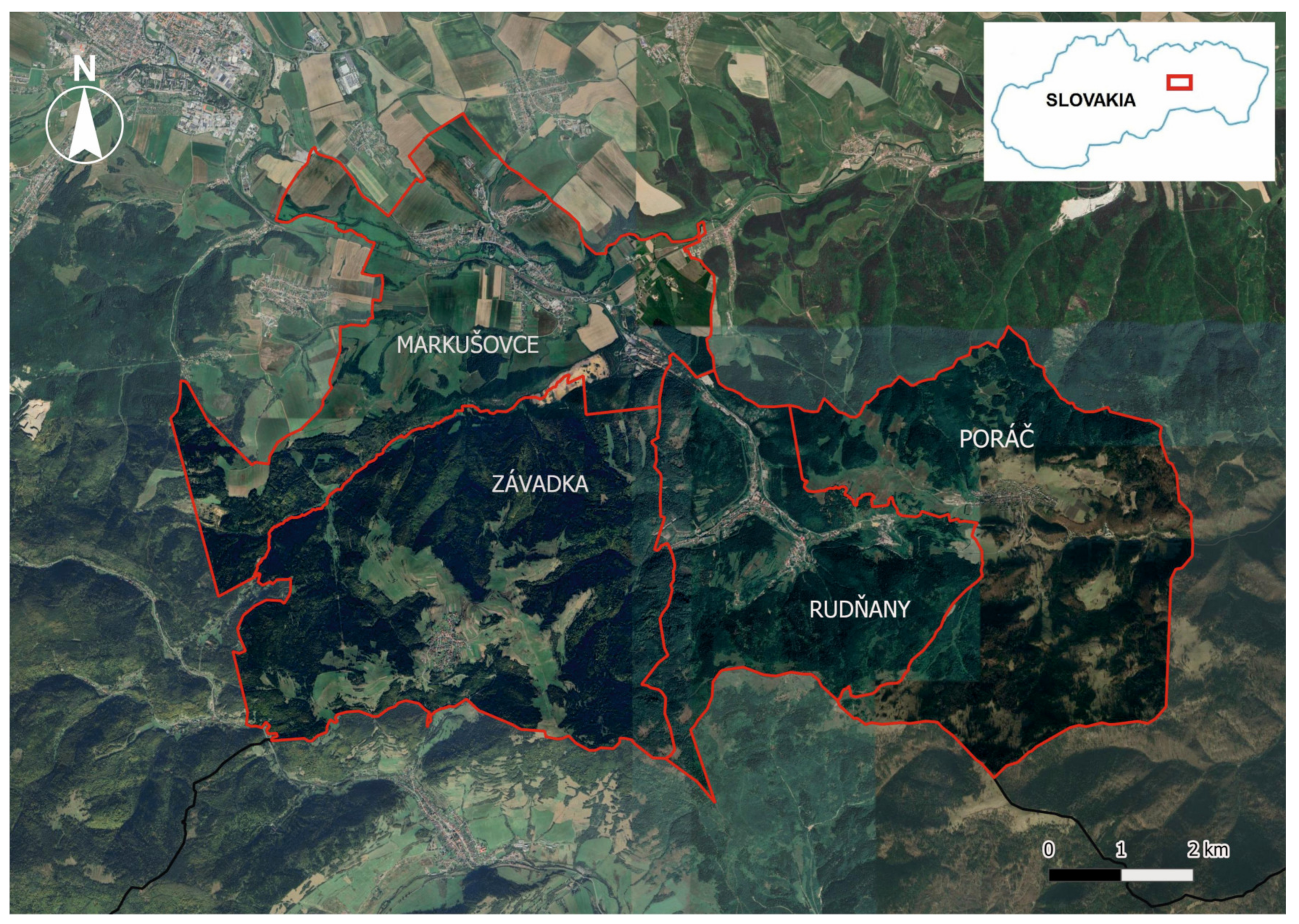
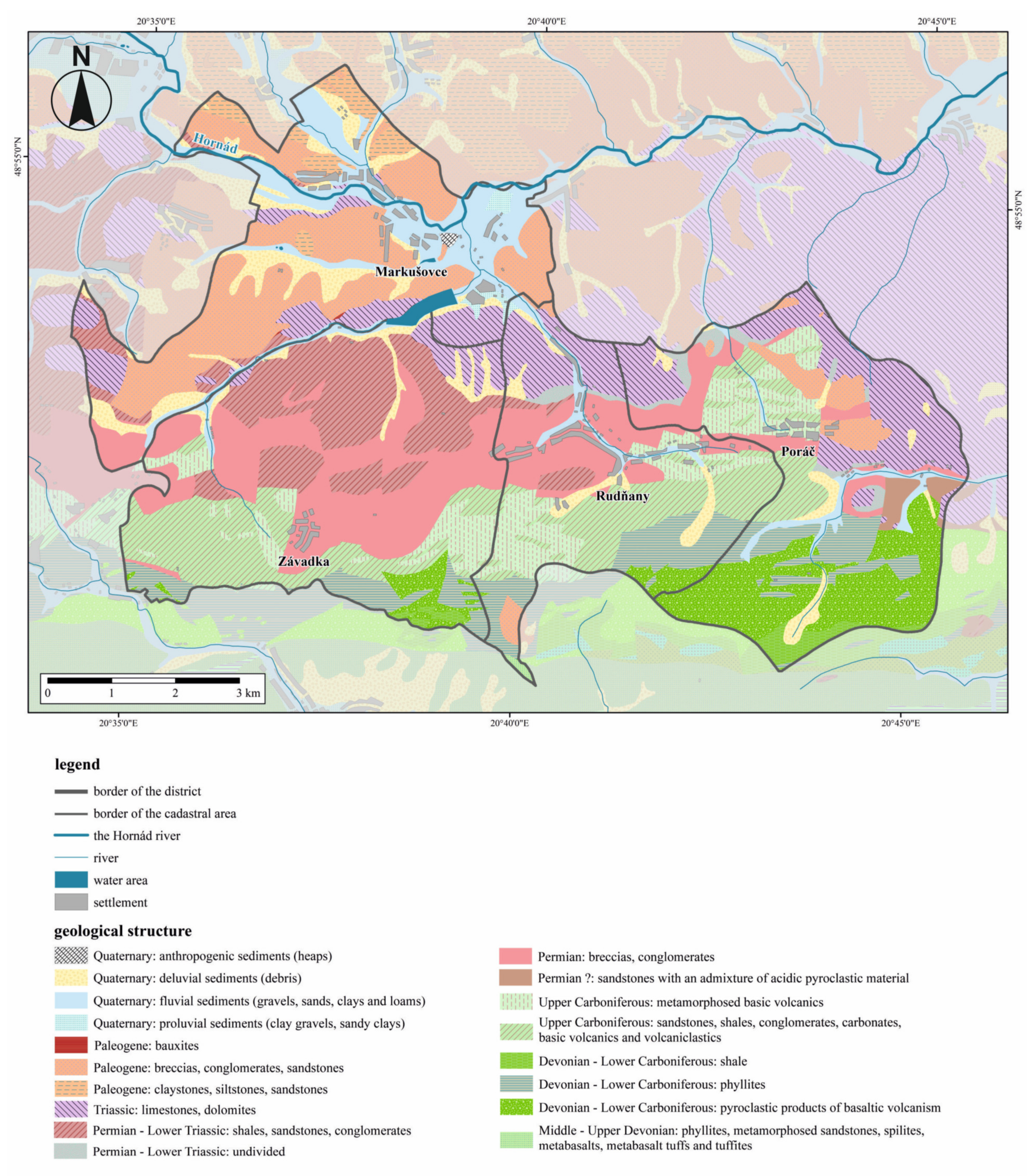
2. Study Area
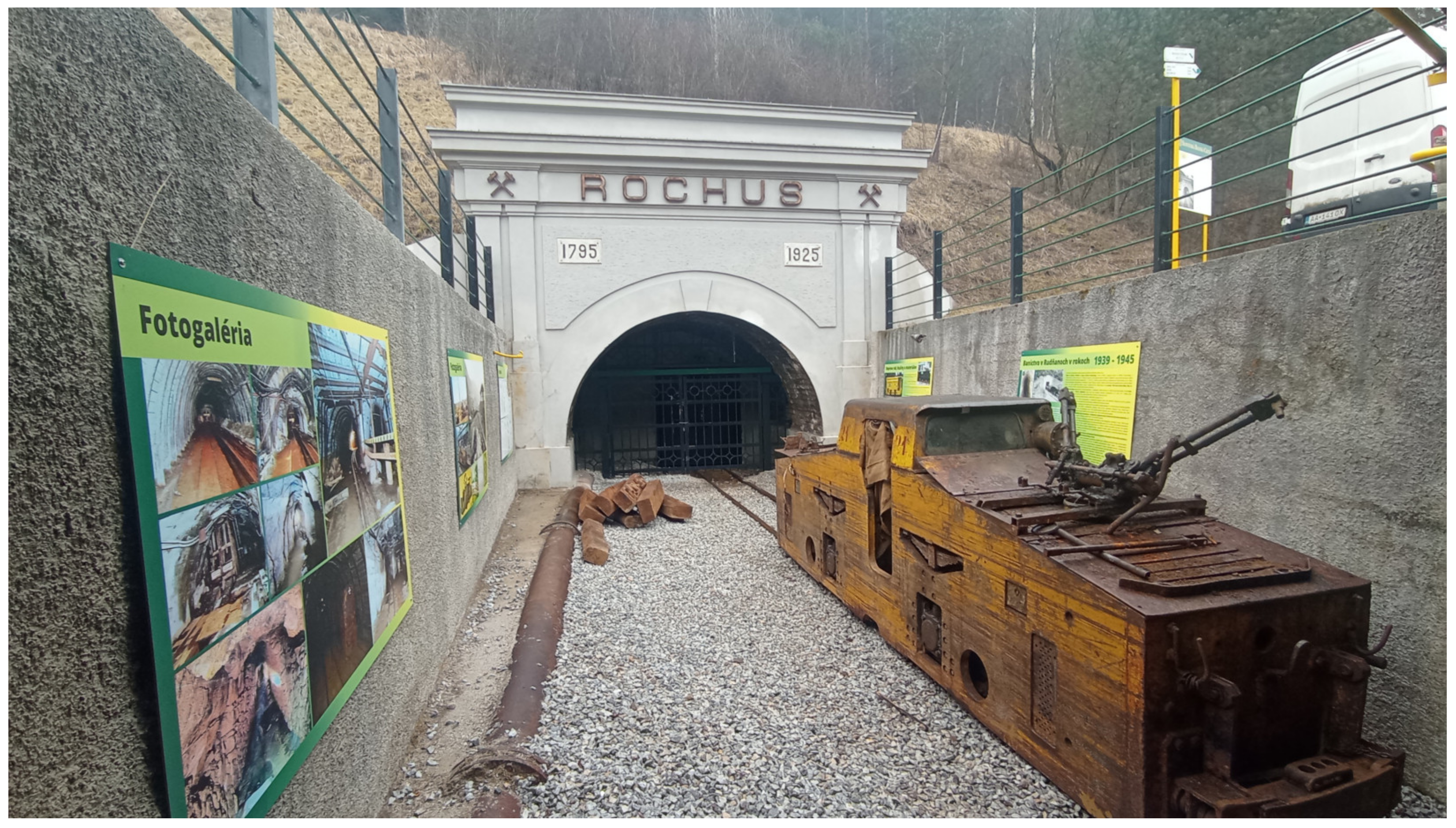
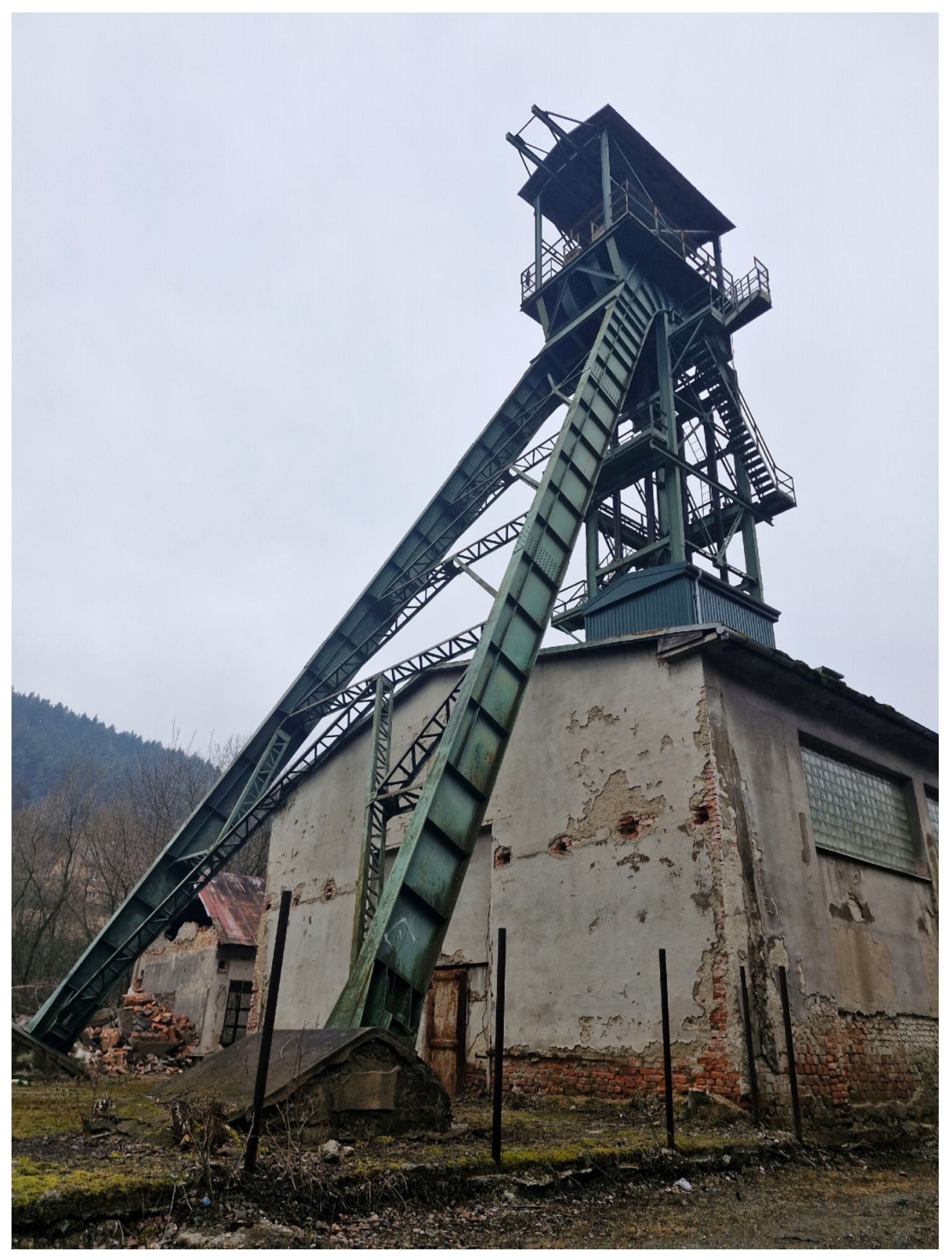
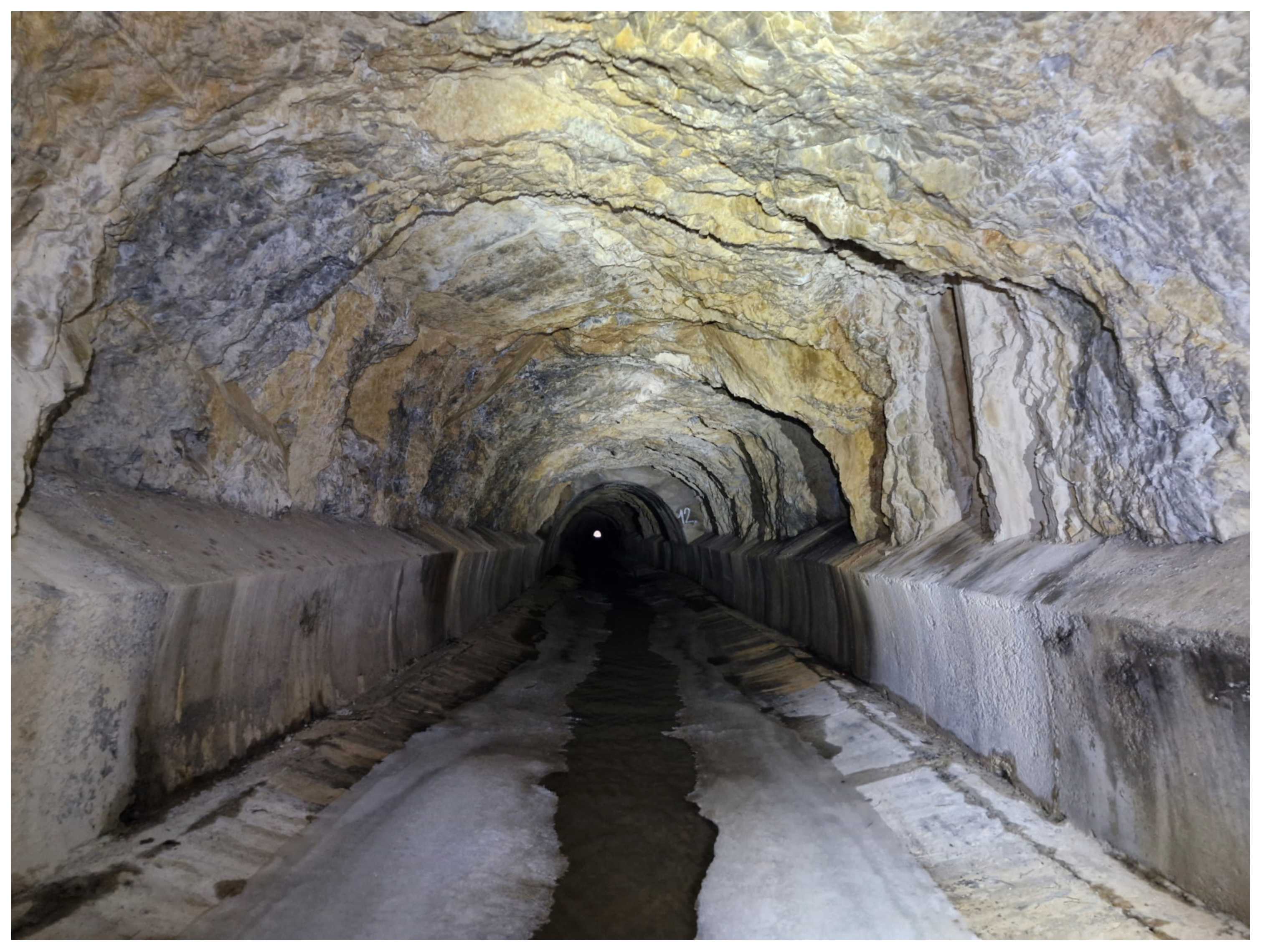
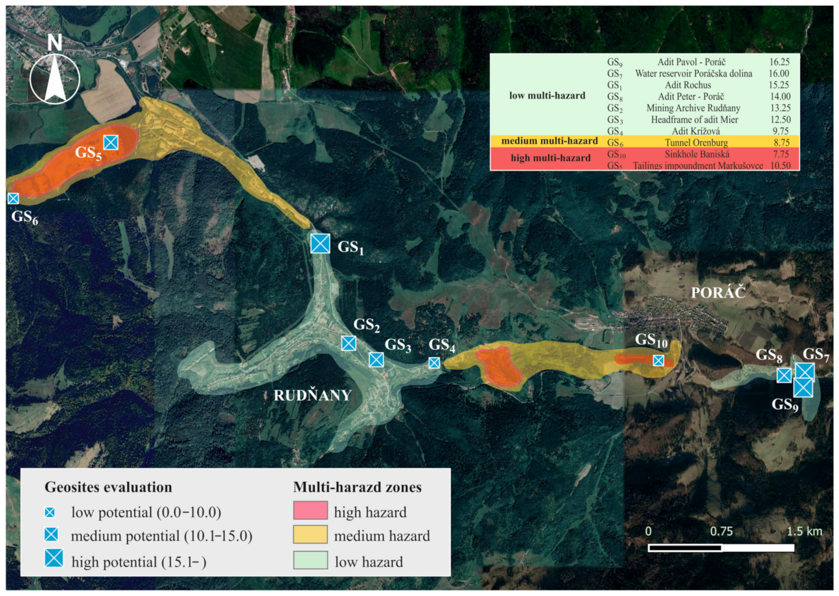
Studied Geosites
3. Materials and Methods
4. Results
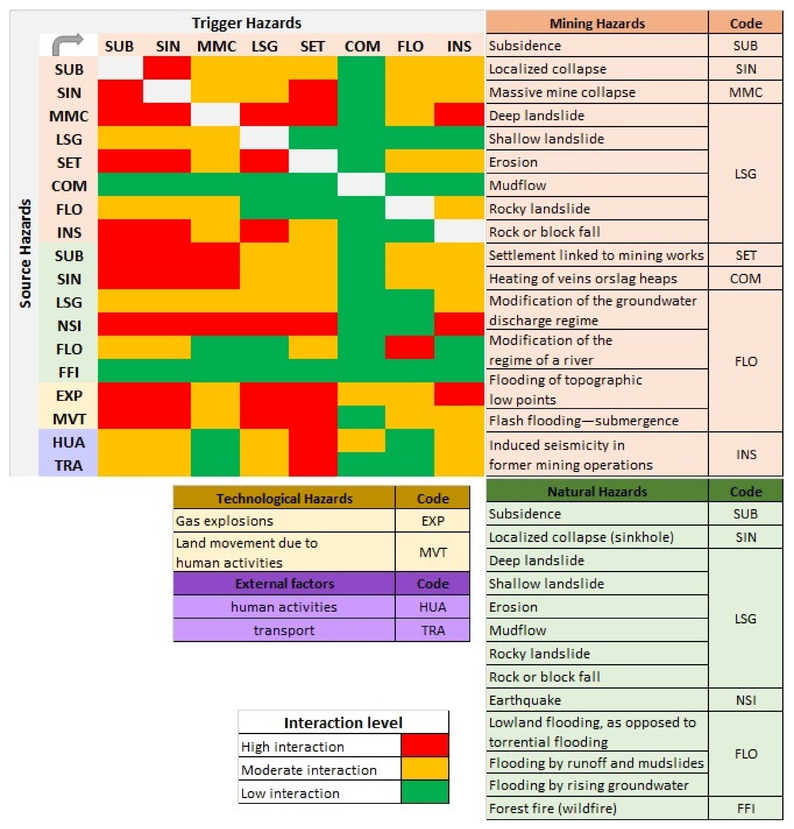
4.1. Analysis of the Study Region Using the Multi-Hazard Interaction Matrix Tool
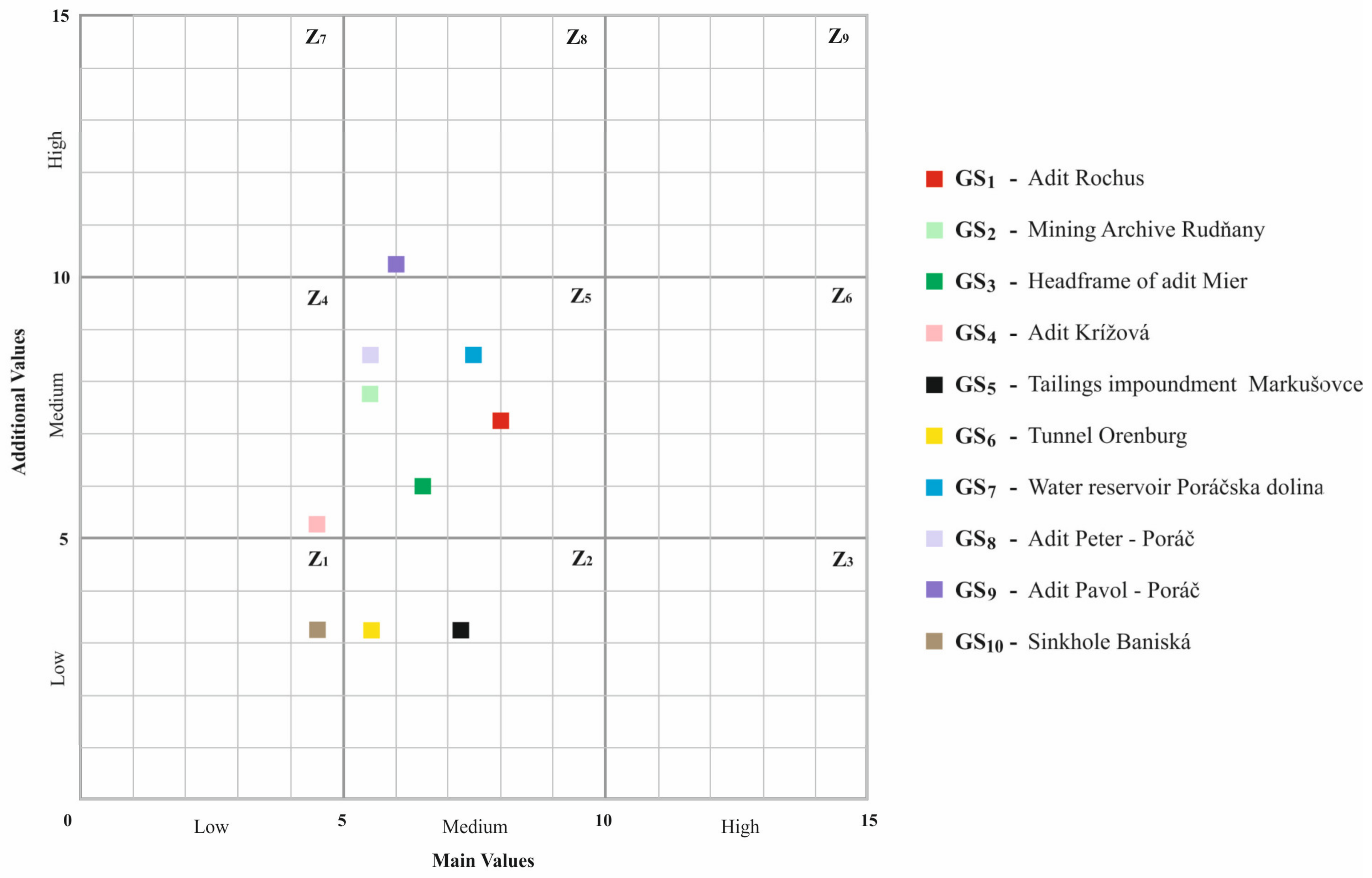
4.2. Analysis of Selected Mining Landforms Using the Interaction Diagram Tool
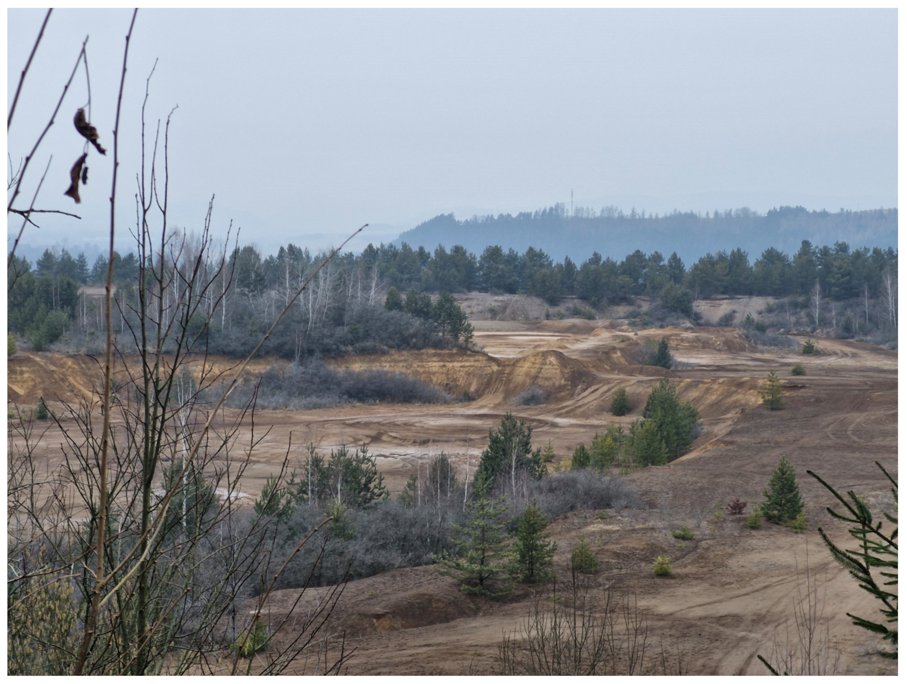
4.2.1. Sinkhole Baniská
4.2.2. Mining Tailings Impoundment “Markušovce”
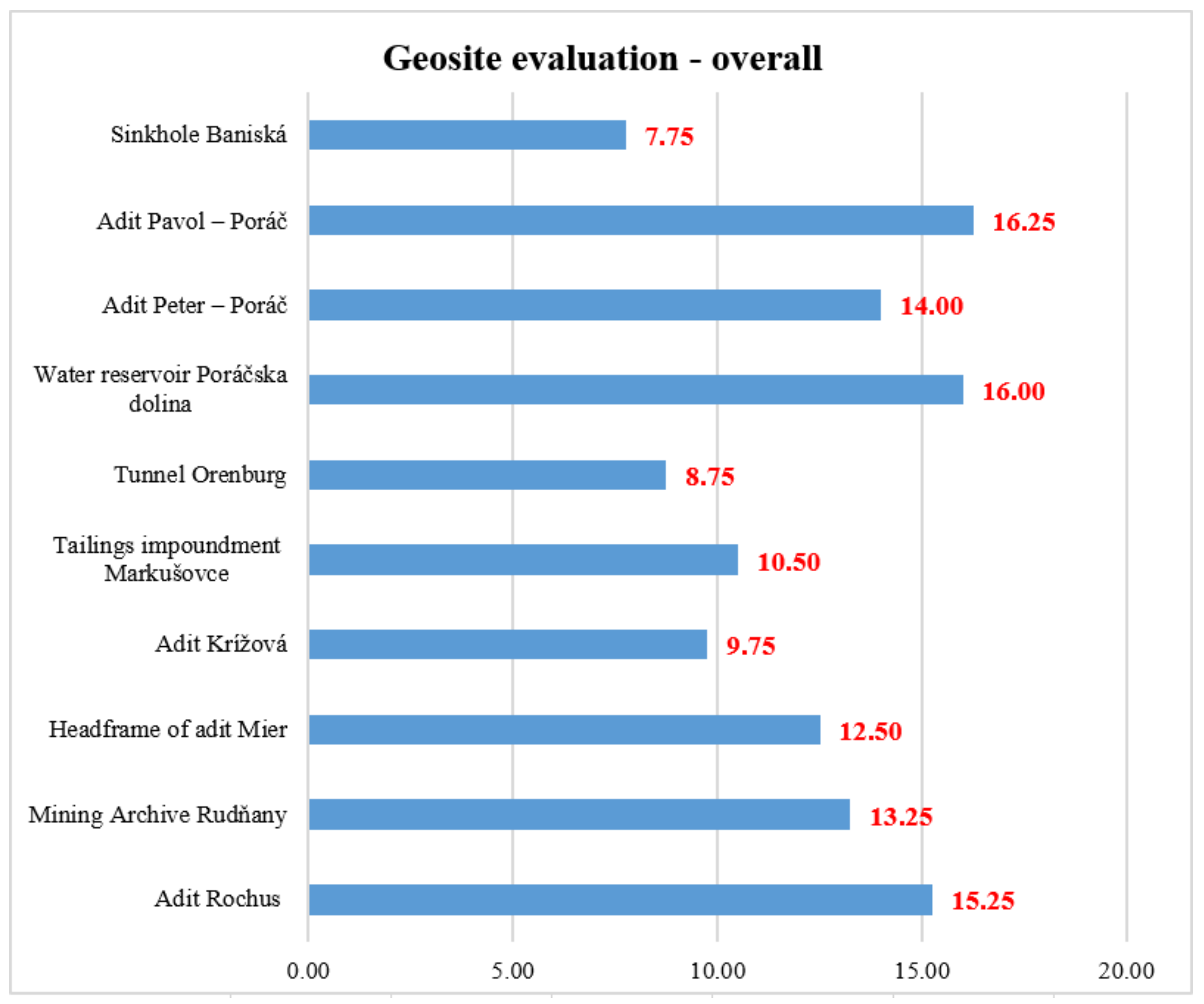
4.3. Analysis of Geosites Using the Geosite Assessment Model (GAM)
5. Discussion
6. Conclusions
Author Contributions
Funding
Data Availability Statement
Conflicts of Interest
References
- Delmonaco, G.; Margottini, C.; Spizzichino, D. Report on a New Methodology for Multi-Risk Assessment and the Harmonisation of Different Natural Risk Maps. Deliverable 3.1; ARMONIA: Rome, Italy, 2006. [Google Scholar]
- Mavrommatis, A.; Damigos, D.; Mirasgedis, S. Towards a comprehensive framework for climate change multi-risk assessment in the mining industry. Infrastructures 2019, 4, 38. [Google Scholar] [CrossRef]
- Sigtryggsdottir, F.G.; Snæbjörnsson, J.T.; Grande, L.; Sigbjörnsson, R. Methodology for geohazard assessment for hydropower projects. Nat. Hazards 2015, 79, 1299–1331. [Google Scholar] [CrossRef]
- Hancuľák, J.; Bobro, M.; Šestinová, O.; Brehuv, J.; Slančo, P. Ortuť v prostredí starých banských záťaží Rudnian a Merníka. Acta Montan. Slovaca 2006, 11, 295–299. [Google Scholar]
- Bajtoš, P.; Záhorová, Ľ.; Rapant, S.; Pramuka, S. Geological monitoring of mining influence on the environment in risk-bearing slovak areas in years 2007–2011. Miner. Slovaca 2012, 44, 375–392. [Google Scholar]
- Liščák, P.; Bajtoš, P.; Mašlár, P.; Mašlárová, I. Vplyv Ťažby Nerastov na Životné Prostredie. Podsystém 04: Vplyv Ťažby Nerastov na Životné Prostredie; GÚDŠ: Spišská Nová Ves, Slovakia, 2015; 77p. [Google Scholar]
- Petrák, M.; Kučerová, G.; Tóth, R.; Lalinská-Voleková, B.; Šottník, P.; Jurkovič, Ľ.; Hiller, E.; Vozár, J. Mineralogické a geochemické hodnotenie materiálu odkaliska Markušovce. Miner. Slovaca 2011, 43, 395–408. [Google Scholar]
- Šottník, P.; Jurkovič, Ľ.; Vozár, J.; Lalinská-Voleková, B. Geochemical and mineralogical evaluation of Slovinky tailing impoundment material (Slovakia). In Proceedings of the 11th International Multidisciplinary Scientific Geo Conference, Albena, Bulgaria, 20–25 June 2011; STEF92 Technology Ltd.: Sofia, Bulgaria, 2011; pp. 375–380. [Google Scholar]
- Tóth, R.; Hiller, E.; Petrák, M.; Jurkovič, Ľ.; Šottník, P.; Vozár, J.; Peťková, K. Tailing impoundments Markušovce and Slovinky: Application of the methodology for evaluation impoundment sediments from ore processing on the model impoundments. Miner. Slovaca 2013, 45, 125–130. [Google Scholar]
- Čech, V.; Krokusová, J.; Kunaková, L. Odkalisko Slovinky pri Krompachoch: (geografické aspekty environmentálnej záťaže). Folia Geogr. 2011, 17, 64–81. [Google Scholar]
- Čech, V.; Michaleli, E.; Krokusová, J.; Ivanová, M. Contamination of selected components of environment in the middle Spiš region (Slovak republic). Int. Sci. Conf. Geobalc. 2015, 1, 43–49. [Google Scholar]
- Michaeli, E.; Krokusová, J.; Solár, V.; Ivanová, M. Flotation tailings pond as the environmental load in the middle Spiš at the village Markušovce and the proposals on the remediation. In Ecology, Economics, Education and Legislation, Proceedings of the 16th International Multidisciplinary Scientific Geoconference SGEM, Albena, Bulgaria, 30 June–6 July 2016; STEF92 Technology: Sofia, Bulgaria, 2016; pp. 311–318. [Google Scholar]
- Krokusová, J.; Pasternák, T. Potenciál bývalých baníckych obcí stredného Spiša (Rudňany a Slovinky) pre vznik ekomúzea. Folia Oecol. 2016, 8, 58–71. [Google Scholar]
- Čech, V.; Krokusová, J. Utilisation of environmentally degraded area by mining activity: A case study of Slovinky tailing impoundment in Slovakia. Acta Montan. Slovaca 2017, 22, 180–192. [Google Scholar]
- Hronček, P.; Čech, P.; Krokusová, J.; Demková, L. Analýza obsahu ťažkých kovov v Slovinskom potoku v Strednospišskej zaťaženej oblasti. Geogr. Cassoviensis 2017, 11, 111–123. [Google Scholar]
- Čech, V.; Hrončeková Gregorová, B.; Krokusová, J.; Košová, V.; Hronček, P.; Molokáč, M.; Hlaváčová, J. Environmentally degraded mining areas of eastern Slovakia as a potential object of geotourism. Sustainability 2020, 12, 6029. [Google Scholar] [CrossRef]
- Čech, V.; Krokusová, J. Challenges and risks of geotourism development on the example of the former mining region of the central Spiš in Slovakia. In Ecology and Environmental Protection, Proceedings of the International Multidisciplinary Scientific Geoconference: Science and Technologies in Geology, Exploration and Mining, Albena, Bulgaria, 1–7 July 2024; Trofymchuk, O., Rivza, B., Eds.; STEF92 Technology Ltd.: Sofia, Bulgaria, 2024; pp. 33–40. [Google Scholar]
- Etigemane, H.; Muniswamy, D. Spatial Distribution of Heavy Metals around the Gold Mine Ore Tailings of Hatti, Karnataka State, India. Landsc. Environ. 2018, 11, 35–44. [Google Scholar]
- Gutierrez, M.; Collette, Z.; Mcclanahan, A.; Mickus, K. Mobility of Metals in Sediments Contaminated with Historical Mining Wastes: Example from the Tri-State Mining District, USA. Soil Syst. 2019, 3, 22. [Google Scholar] [CrossRef]
- Wang, P.; Sun, Z.; Hu, Y.; Cheng, H. Leaching of heavy metals from abandoned mine tailings brought by precipitation and the associated environmental impact. Sci. Total Environ. 2019, 695, 133893. [Google Scholar] [CrossRef]
- Zhang, X.; Yang, L.; Li, Y.; Li, H.; Wang, W.; Ye, B. Impacts of lead/zinc mining and smelting on the environment and human health in China. Environ. Monit. Assess. 2011, 184, 2261–2273. [Google Scholar] [CrossRef]
- Sarker, S.K.; Haque, N.; Bhuiyan, M.; Bruckard, W.; Pramanik, B.K. Recovery of strategically important critical minerals from mine tailings. J. Environ. Chem. Eng. 2022, 10, 107622. [Google Scholar] [CrossRef]
- MPAO. Ministerstvo Průmyslu a Obchodu. Národní Strategie Regenerace Brownfieldů; MPAO: Praha, Czech Republic, 2008; 12p.
- Chen, X.W.; Wong, J.T.F.; Leung, A.O.W.; Ng, C.W.W.; Wong, M.H. Comparison of plant and bacterial communities between a subtropical landfill topsoil 15 years after restoration and a natural area. Waste Manag. 2017, 63, 49–57. [Google Scholar] [CrossRef]
- Pełka-Gościniak, J. Restoring nature in mining areas of the Silesian Upland (Poland). Earth Surf. Process. Landf. 2006, 31, 1685–1691. [Google Scholar] [CrossRef]
- Gregorová, B.; Hronček, P.; Tometzová, D.; Molokáč, M.; Čech, V. Transforming Brownfields as Tourism Destinations and Their Sustainability on the Example of Slovakia. Sustainability 2020, 12, 10569. [Google Scholar] [CrossRef]
- Kantor-Pietraga, I.; Zdyrko, A.; Bednarczyk, J. Semi-natural areas on post-mining brownfields as an opportunity to strengthen the attractiveness of a small town. An example of radzionków in southern Poland. Land 2021, 10, 761. [Google Scholar] [CrossRef]
- Hajduková, R.; Sopirová, A. Perspectives of Post-Industrial Towns and Landscape in Eastern Slovakia—Case Study Strážske. Land 2022, 11, 1114. [Google Scholar] [CrossRef]
- Rostański, K.M. Contaminated Areas as Recreational Places—Exploring the Validity of the Decisions Taken in the Development of Antonia Hill in Ruda Śląska, Poland. Land 2021, 10, 1165. [Google Scholar] [CrossRef]
- Lamparska, M. Post-mining tourism in Upper Silesia and Czech-Moravian country. J. Geogr. Politics Soc. 2019, 9, 57–68. [Google Scholar] [CrossRef]
- Różycki, P.; Dryglas, D. Mining tourism, sacral and other forms of tourism practiced in antique mines—Analysis of the results. Acta Montan. Slovaca 2017, 22, 58–66. [Google Scholar]
- Rybár, P.; Hronček, P. Mining tourism and the search for its origins. Geotourism 2017, 50–51, 27–66. [Google Scholar] [CrossRef]
- Guo, S.; Yang, S.; Liu, C. Mining Heritage Reuse Risks: A Systematic Review. Sustainability 2024, 16, 4048. [Google Scholar] [CrossRef]
- Pavolová, H.; Bakalár, T.; Molokáč, M. Management of Mining Brownfields for Support of Regional Tourism. Sustainability 2024, 16, 7986. [Google Scholar] [CrossRef]
- Koudelková, J.; Urbanec, V.; Korandová, B.; Hummel, M. Geomontaneous tourism and the possibilities of utilizing abandoned mine workings in the Czech Republic. Geoheritage 2022, 14, 29. [Google Scholar] [CrossRef]
- Saputra, B.; Fajri, H.; Pegi, A.L.; Halawa, H.S.; Renaldi, I.; Syolendra, D.F. From mining to tourism: Sustainable management of the former mining area of Tebing Breksi. IOP Conf. Ser. Earth Environ. Sci. 2025, 1438, 012036. [Google Scholar] [CrossRef]
- Wimbledon, W.A.P. Geosites, a new conservation initiative. Episodes 1996, 19, 87–88. [Google Scholar] [CrossRef]
- Brilha, J. Inventory and Quantitative Assessment of Geosites and Geodiversity Sites—A Review. Geoheritage 2016, 8, 119–134. [Google Scholar] [CrossRef]
- Ruban, D.A.; Kuo, I. Essentials of geological heritage site (geosite) management: A conceptual assessment of interests and conflicts. Nat. Nascosta 2010, 41, 16–31. [Google Scholar]
- Reynard, E. Geosite. In Encyclopedia of Geomorphology (2 Volume Set); Goudie, A.S., Ed.; Routledge: London, UK; New York, NY, USA, 2004; p. 440. [Google Scholar]
- Miśkiewicz, K.; Waśkowska, A.; Małgorzata Welc, E. Documentation and Assessment of Geosites for Geotourism and Geoparks; E-textbook; AGH University of Krakow: Kraków, Poland, 2024; 111p. [Google Scholar]
- Malatinský, K.; Popovič, M. Z Dejín Baníctva v Rudňanoch; Východoslovenské Vydavateľstvo: Košice, Slovakia, 1985; 136p. [Google Scholar]
- Available online: www.statistics.sk (accessed on 24 April 2025).
- Mello, P.; Filo, I.; Havrila, M.; Ivanička, J.; Madarás, J.; Németh, Z.; Polák, M.; Pristaš, J.; Vozár, J.; Koša, E.; et al. Geologická Mapa Slovenského Raja, Galmusu a Hornádskej Kotliny 1:50,000; MŽP SR—ŠGÚDŠ: Bratislava, Slovakia, 2000. [Google Scholar]
- Mello, J.; Filo, I.; Havrila, M.; Ivan, P.; Ivanička, J.; Madarás, J.; Németh, Z.; Polák, M.; Pristaš, J.; Vozár, J.; et al. Vysvetlivky ku Geologickej Mape Slovenského Raja, Galmusu a Hornádskej Kotliny 1:50,000; ŠGÚDŠ: Bratislava, Slovakia, 2000; 303p. [Google Scholar]
- Al Heib, M.M.; Franck, C.; Djizanne, H.; Degas, M. Post-mining multi-hazard assessment for sustainable development. Sustainability 2023, 15, 8139. [Google Scholar] [CrossRef]
- Reynard, E.; Fontana, G.; Kozlik, L.; Scapozza, C. A method for assessing “scientific” and “additional values” of geomorphosites. Geogr. Helv. 2007, 62, 148–158. [Google Scholar] [CrossRef]
- Erhartič, B. Geomorphosite assessment. Acta Geogr. Slov. 2010, 50, 295–319. [Google Scholar] [CrossRef]
- Pereira, P.; Pereira, D.; Caetano Alves, M.I. Geomorphosite assessment in Montesinho Natural Park (Portugal). Geogr. Helv. 2007, 62, 159–168. [Google Scholar] [CrossRef]
- Serrano, E.; González-Trueba, J.J. Assessment of geomorphosites in natural protected areas: The Picos de Europa National Park (Spain). Géomorphol. Relief Process. Environ. 2005, 11, 197–208. [Google Scholar] [CrossRef]
- Pralong, J.P. A method for assessing tourist potential and use of geomorphological sites. Géomorphol. Relief Process. Environ. 2005, 11, 189–196. [Google Scholar] [CrossRef]
- Vujičić, M.D.; Vasiljević, D.A.; Marković, S.B.; Hose, T.A.; Lukić, T.; Hadžić, O.; Janičević, S. Preliminary geosite assessment model (gam) and its application on Fruška gora mountain, potential geotourism destination of Serbia. Acta Geogr. Slov. 2011, 51, 361–376. [Google Scholar] [CrossRef]
- Kudla, M.; Javorská, M.; Vašková, J.; Čech, V.; Tometzová, D. Inventory and Evaluation of Geosites: Case Studies of the Slovak Karst as a Potential Geopark in Slovakia. Sustainability 2024, 16, 7783. [Google Scholar] [CrossRef]
- Angelovičová, L.; Fazekašová, D. Contamination of the soil and water environment by heavy metals in the former mining area of Rudňany (Slovakia). Soil Water Res. 2014, 9, 18–24. [Google Scholar] [CrossRef]
- Bajtoš, P. Use of analysis of seasonal hydrochemical regime for better understanding of mine water genesis and more accurate estimate of its impact on stream water quality at flooded Rudňany ore mine (North-Gemeric zone, Slovakia). Miner. Slovaca 2022, 54, 47–68. [Google Scholar] [CrossRef]
- Bajtoš, P.; Mašlár, P.; Mašlárová, I. Vplyv Ťažby Nerastov na Životné Prostredie. Podsystém 04: Vplyv Ťažby Nerastov na Životné Prostredie; GÚDŠ: Spišská Nová Ves, Slovakia, 2020; 124p. [Google Scholar]
- Bajtoš, P. Severná Časť Rudnianskeho Rudného Poľa, Hydrogeologická Štúdia; Manuskript—Archív GS SR: Bratislava, Slovakia, 1993; 141p. [Google Scholar]
- Bajtoš, P. Novoveská Huta—Banské Vody. Záverečná Správa; Manuskript—Archív GS SR: Bratislava, Slovakia, 1993; 150p. [Google Scholar]
- Krásný, J. Hydrogeological environment in hard rocks: An attempt at its schematizing and terminological considerations. First Workshop on “Hardrock hydrogeology of the Bohemian Massiť” 1994. Acta Univ. Carol. Geol. 1996, 40, 115–122. [Google Scholar]
- Bajtoš, P. Podmienky tvorby banských vôd Rudnianskeho rudného poľa. Podzemn. Voda 1999, 5, 21–33. [Google Scholar]
- Tamang, L.; Mandal, U.K.; Karmakar, M.; Banerjee, M.; Ghosh, D. Geomorphosite evaluation for geotourism development using geosite assessment model (GAM)—A study from a Proterozoic terrain in eastern India. IJoGaP 2022, 11, 82–99. [Google Scholar] [CrossRef]
- Antić, A.; Tomić, N.; Marković, S. Applying the show cave assessment model (SCAM) on cave tourism destinations in Serbia. Int. J. Geoherit. Parks 2022, 10, 616–634. [Google Scholar] [CrossRef]
- Antić, A.; Tomić, N.; Đorđević, T.; Radulović, M.; Đević, I. Speleological Objects Becoming Show Caves—Evidence from the Valjevo karst area in Western Serbia. Geoheritage 2020, 12, 95. [Google Scholar] [CrossRef]
- Rybár, P.; Sasvári, T.; Hvizdák, L.; Hvizdáková, J.; Baláž, B. Geotouristic excursion to selected historical mining sites developed by Slovak and German miners in the Gelnica-Smolník region, Slovakia. Geotourism/Geoturystyka 2010, 20, 23–30. [Google Scholar] [CrossRef]
- Tost, M.; Ammerer, G.; Kot-Niewiadomska, A.; Gugerell, K. Mining and Europe’s World Heritage Cultural Landscapes. Resources 2021, 10, 18. [Google Scholar] [CrossRef]
- Urban, J.; Radwanek-Bąk, B.; Margielewski, W. Geoheritage concept in a context of abiotic ecosystem services (geosystem services)—How to argue the geoconservation better? Geoheritage 2022, 14, 54. [Google Scholar] [CrossRef]
- Haske, B.; Al Heib, M.; Inojosa, V.; Bouaziz, M. Spatial Decision Support System for Multi-Risk Assessment of Post-Mining Hazards. Mining 2025, 5, 17. [Google Scholar] [CrossRef]
- Pál, M.; Albert, G. Examining the Spatial Variability of Geosite Assessment and Its Relevance in Geosite Management. Geoheritage 2021, 13, 8. [Google Scholar] [CrossRef]
- Tomić, N.; Božić, S. A modified geosite assessment model (MGAM) and its application on the Lazar Canyon area (Serbia). Int. J. Environ. Res. 2014, 8, 1041–1052. [Google Scholar]
- Božić, S.; Tomić, N.; Pavić, D. Canyons as potential geotourism attractions of Serbia—Comparative analysis of Lazar and Uvac canyons by using M-GAM model. Acta Geotur. 2014, 5, 18–30. [Google Scholar]
- Jonić, V. Comparative analysis of Devil’s town and Bryce canyon geosites by applying the modified geosite assessment model (M-GAM). Res. Rev. Dep. Geogr. Tour. Hotel Manag. 2018, 47, 113–125. [Google Scholar] [CrossRef]
- Zorlu, K.; Dede, V.; Zorlu, B.S.; Serin, S. Quantitative assessment of geoheritage with the GAM and MEREC-based PROMETHEE-GAIA method. Resour. Policy 2023, 84, 103796. [Google Scholar] [CrossRef]


| Scientific/Educational Value (VSE) | ||||||
|---|---|---|---|---|---|---|
| Indicators and Descriptions | Grades (0–1) | |||||
| Indicators | Description | 0 | 0.25 | 0.5 | 0.75 | 1 |
| I1 Rarity | Number of closest identical sites. | Common | Regional | National | International | The only occurrence |
| I2 Representativeness | Didactic and exemplary characteristics of the site due to its own quality and general configuration. | None | Low | Moderate | High | Utmost |
| I3 Knowledge on geoscientific issues | Number of written works in acknowledged journals, thesis, presentations and other publications. | None | Local publications | Regional publications | National publications | International publications |
| I4 Level of interpretation | Level of interpretive possibilities on geological and geomorphologic processes, phenomena and shapes and level of scientific knowledge. | None | Moderate level of processes but hard to explain to non-experts | Good example of processes but hard to explain to non-experts | Moderate level of processes but easy to explain to common visitor | Good example of processes and easy to explain common visitor |
| I5 Research and education “in situ” | The possibility of scientific research, or education directly at the geosite—suitability of space, availability, need for permits, etc. | None | Low | Moderate | High | Utmost |
| Scenic/Aesthetic value (VSA) | ||||||
| Indicators and descriptions | Grades (0–1) | |||||
| Indicators | Description | 0 | 0.25 | 0.5 | 0.75 | 1 |
| I6 Object visibility | Visibility of the object from the main access road as a factor of interest in the geolocality in question. | None | - | Partial | - | Full |
| I7 Surface | Whole surface of the site. Each site is considered in quantitative relation to other sites. | Small | - | Medium | - | Large |
| I8 Surrounding landscpe and nature | Panoramic view quality, presence of water and vegetation, absence of human-induced deterioration, vicinity of urban area, etc. | - | Low | Medium | High | Utmost |
| I9 Environmental fitting of sites | Level of contrast to the nature, contrast of colors, appearance of shapes, etc. | Unfitting | - | Neutral | - | Fitting |
| I10 Basic physiognomy of the geosite | Predominant geometric shape on the geosite. | Flat, linear | Concave | Convex | Linear–convex | Concave–convex |
| Protection value (VPr) | ||||||
| Indicators and descriptions | Grades (0–1) | |||||
| Indicators | Description | 0 | 0.25 | 0.5 | 0.75 | 1 |
| I11 Current condition | Current state of geosite. | Totally damaged (as a result of human activities) | Highly damaged (as a result of natural processes) | Medium damaged (with essential geomorphologic features preserved) | Slightly damaged | No damage |
| I12 Protection level | Protection by local or regional groups, national government, international organizations, etc. | None | Local | Regional | National | International |
| I13 Vulnerability | Vulnerability level of geosite. | Irreversible (with possibility of total loss) | High (could be easily damaged) | Medium (could be damaged by natural processes or human activities) | Low (could be damaged only by human activities) | None |
| I14 Suitable number of visitors | Proposed number of visitors on the site at the same time, according to surface area, vulnerability and current state of geosite. | 0 | 0 to 10 | 10 to 20 | 20 to 50 | More than 50 |
| I15 Protected biota | Occurrence of specially protected and rare plant and animal species in the geosite | None | 1 | 2 to 3 | 4 to 6 | More than 6 |
| Functional value (VFn) | ||||||
| Indicators and descriptions | Grades (0–1) | |||||
| Indicators | Description | 0 | 0.25 | 0.5 | 0.75 | 1 |
| I16 Accessibility | Possibilities of approaching to the site. | Inaccessible | Low (on foot with special equipment and expert guide tours) | Medium (by bicycle and other means of man-powered transport) | High (by car) | Utmost (by bus) |
| I17 Additional natural values | Number of additional natural values in a radius of 5 km (geosites also included). | None | 1 | 2 to 3 | 4 to 6 | More than 6 |
| I18 Additional anthropogenic values | Number of additional anthropogenic values in the in a radius of 5 km. | None | 1 | 2 to 3 | 4 to 6 | More than 6 |
| I19 Vicinity of emissive centers | Closeness of emissive centers. | Less than 5 km | 5 to 25 km | 25 to 50 km | 50 to 100 km | More than 100 km |
| I20 Vicinity of important road network | Closeness of important road networks in a radius of 20 km. | None | Local | Regional | National | International |
| I21 Additional functional values | Parking lots, gas stations, mechanics, etc. | None | Low | Moderate | High | Utmost |
| Touristic value (VTr) | ||||||
| Indicators and descriptions | Grades (0–1) | |||||
| Indicators | Description | 0 | 0.25 | 0.5 | 0.75 | 1 |
| I22 Promotion | Level and number of promotional resources. | None | Local | Regional | National | International |
| I23 Organized visits | Annual number of organized visits to the geosite. | None | Less than 12 per year | 12 to 24 per year | 24 to 48 per year | More than 48 per year |
| I24 Vicinity of visitors center | Closeness of visitor center to the geosite. | More than 50 km | 50 to 20 km | 20 to 5 km | 5 to 1 km | Less than 1 km |
| I25 Interpretative panels | Interpretative characteristics of text and graphics, material quality, size, fitting to surroundings, etc. | None | Low quality | Medium quality | High quality | Utmost quality |
| I26 Number of visitors | Annual number of visitors. | None | Low (less than 5000) | Medium (5001 to 10,000) | High (10,001 to 100,000) | Utmost (more than 100,000) |
| I27 Tourism infrastructure | Level of additional infrastructure for tourist (pedestrian pathways, resting places, garbage cans, toilets, wellsprings, etc.). | None | Low | Medium | High | Utmost |
| I28 Tour guide service | If exists, expertise level, knowledge of foreign language(s), interpretative skills, etc. | None | Low | Medium | High | Utmost |
| I29 Hostelry service | Hostelry service close to geosite. | More than 50 km | 25–50 km | 10–25 km | 5–10 km | Less than 5 km |
| I30 Restaurant service | Restaurant service close to geosite. | More than 25 km | 10–25 km | 10–5 km | 1–5 km | Less than 1 km |
| Geosite Label | Geosite Name | Main Values | Sum Main Values | Additional Values | Sum Additional Values | Overall | Field | |||
|---|---|---|---|---|---|---|---|---|---|---|
| VSE | VSA | VPr | VFn | VTr | ||||||
| GS1 | Adit Rochus | 2.75 | 2.50 | 2.75 | 8.00 | 3.00 | 4.25 | 7.25 | 15.25 | Z5 |
| GS2 | Mining Archive Rudňany | 2.00 | 1.25 | 2.25 | 5.50 | 3.00 | 4.75 | 7.75 | 13.25 | Z5 |
| GS3 | Headframe of adit Mier | 2.00 | 2.25 | 2.25 | 6.50 | 2.50 | 3.50 | 6.00 | 12.50 | Z5 |
| GS4 | Adit Krížová | 2.00 | 0.75 | 1.75 | 4.50 | 2.25 | 3.00 | 5.25 | 9.75 | Z4 |
| GS5 | Tailings impoundment Markušovce | 3.75 | 1.50 | 2.00 | 7.25 | 1.75 | 1.50 | 3.25 | 10.50 | Z2 |
| GS6 | Tunnel Orenburg | 1.75 | 1.75 | 2.00 | 5.50 | 2.00 | 1.25 | 3.25 | 8.75 | Z2 |
| GS7 | Water reservoir Poráčska dolina | 2.25 | 2.50 | 2.75 | 7.50 | 2.75 | 5.75 | 8.50 | 16.00 | Z5 |
| GS8 | Adit Peter, Poráč | 2.00 | 1.75 | 1.75 | 5.50 | 2.75 | 5.75 | 8.50 | 14.00 | Z5 |
| GS9 | Adit Pavol, Poráč | 2.25 | 1.75 | 2.00 | 6.00 | 3.50 | 6.75 | 10.25 | 16.25 | Z8 |
| GS10 | Sinkhole Baniská | 2.25 | 1.50 | 0.75 | 4.50 | 1.75 | 1.50 | 3.25 | 7.75 | Z1 |
Disclaimer/Publisher’s Note: The statements, opinions and data contained in all publications are solely those of the individual author(s) and contributor(s) and not of MDPI and/or the editor(s). MDPI and/or the editor(s) disclaim responsibility for any injury to people or property resulting from any ideas, methods, instructions or products referred to in the content. |
© 2025 by the authors. Licensee MDPI, Basel, Switzerland. This article is an open access article distributed under the terms and conditions of the Creative Commons Attribution (CC BY) license (https://creativecommons.org/licenses/by/4.0/).
Share and Cite
Čech, V.; Klamár, R.; Krokusová, J.; Vašková, J. Multi-Hazard Assessment in Post-Mining Landscape and Potential for Geotourism Development (On the Example of the Central Spiš Region in Slovakia). Land 2025, 14, 1000. https://doi.org/10.3390/land14051000
Čech V, Klamár R, Krokusová J, Vašková J. Multi-Hazard Assessment in Post-Mining Landscape and Potential for Geotourism Development (On the Example of the Central Spiš Region in Slovakia). Land. 2025; 14(5):1000. https://doi.org/10.3390/land14051000
Chicago/Turabian StyleČech, Vladimír, Radoslav Klamár, Juliana Krokusová, and Jana Vašková. 2025. "Multi-Hazard Assessment in Post-Mining Landscape and Potential for Geotourism Development (On the Example of the Central Spiš Region in Slovakia)" Land 14, no. 5: 1000. https://doi.org/10.3390/land14051000
APA StyleČech, V., Klamár, R., Krokusová, J., & Vašková, J. (2025). Multi-Hazard Assessment in Post-Mining Landscape and Potential for Geotourism Development (On the Example of the Central Spiš Region in Slovakia). Land, 14(5), 1000. https://doi.org/10.3390/land14051000