Delineation of and Conflict Coordination in Municipal Territorial Space Functional Zones: A Case Study of Xuzhou, China
Abstract
1. Introduction
2. Theoretical Framework
2.1. Territorial Space Functional Zones and Types of Conflicts
2.2. Research Framework
2.3. Theoretical Proposition of Equilibrium Boundaries
3. Material and Methods
3.1. Study Area
3.2. Data Sources and Preprocessing
3.3. Methods
3.3.1. Delineation Methods for Territorial Space Functional Zones
- (1)
- Delineation method for the FPZ
- (2)
- Delineation methods for the EPZ
- (3)
- Delineation methods for the UDZ
- (1)
- Suitability analysis of urban development and construction
- (2)
- Land use simulation and delineation of urban development zones
3.3.2. Analysis Methods for Territorial Space Functional Zone Conflicts
Conflict Identification Method
3.3.3. Equilibrium Boundary Model
4. Results
4.1. Delineation Results for Territorial Spatial Functional Zones
4.1.1. Delineation Results for the FPZ
4.1.2. Delineation Results for the EPZ
4.1.3. Delineation Results of the UDZ
4.2. Analysis of Territorial Space Functional Zone Conflicts
4.3. Extraction of the SEB
4.4. Coordination of Territorial Space Functional Zone Conflicts
4.4.1. Analysis of Conflicts Within and Outside the SEB
4.4.2. Results for the Coordination of the Conflicts
5. Discussion
5.1. Appropriateness of Selecting the SEB to Resolve Space Conflicts in Xuzhou
5.2. Comparative Analysis of the Optimization Results and Planning Data
5.3. Management Policy Recommendations
- (1)
- Define the primary resolution of conflicts and the direction of territorial space optimization.
- (2)
- Improve the utilization efficiency of construction land and promote multi-center urban development.
- (3)
- Coordinate urban and rural development to make up for the lost APss.
5.4. Contribution to Research, Limitations, and Future Work
6. Conclusions
- (1)
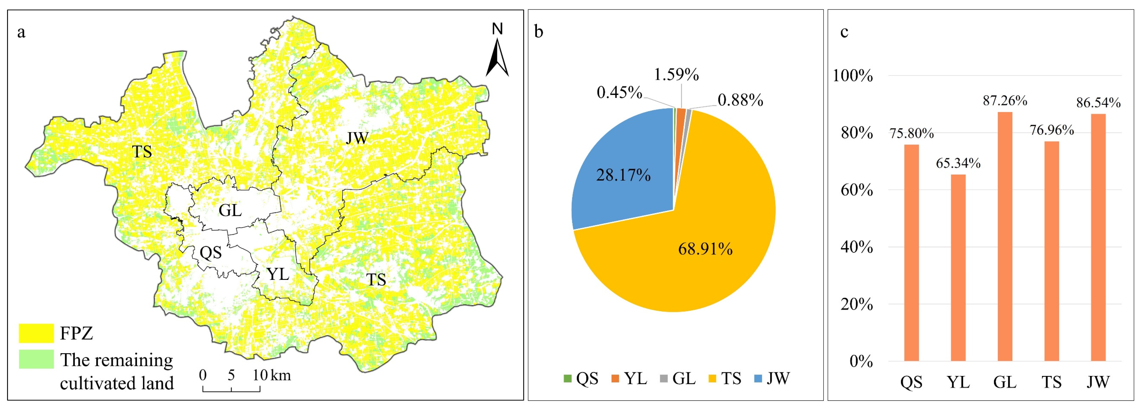
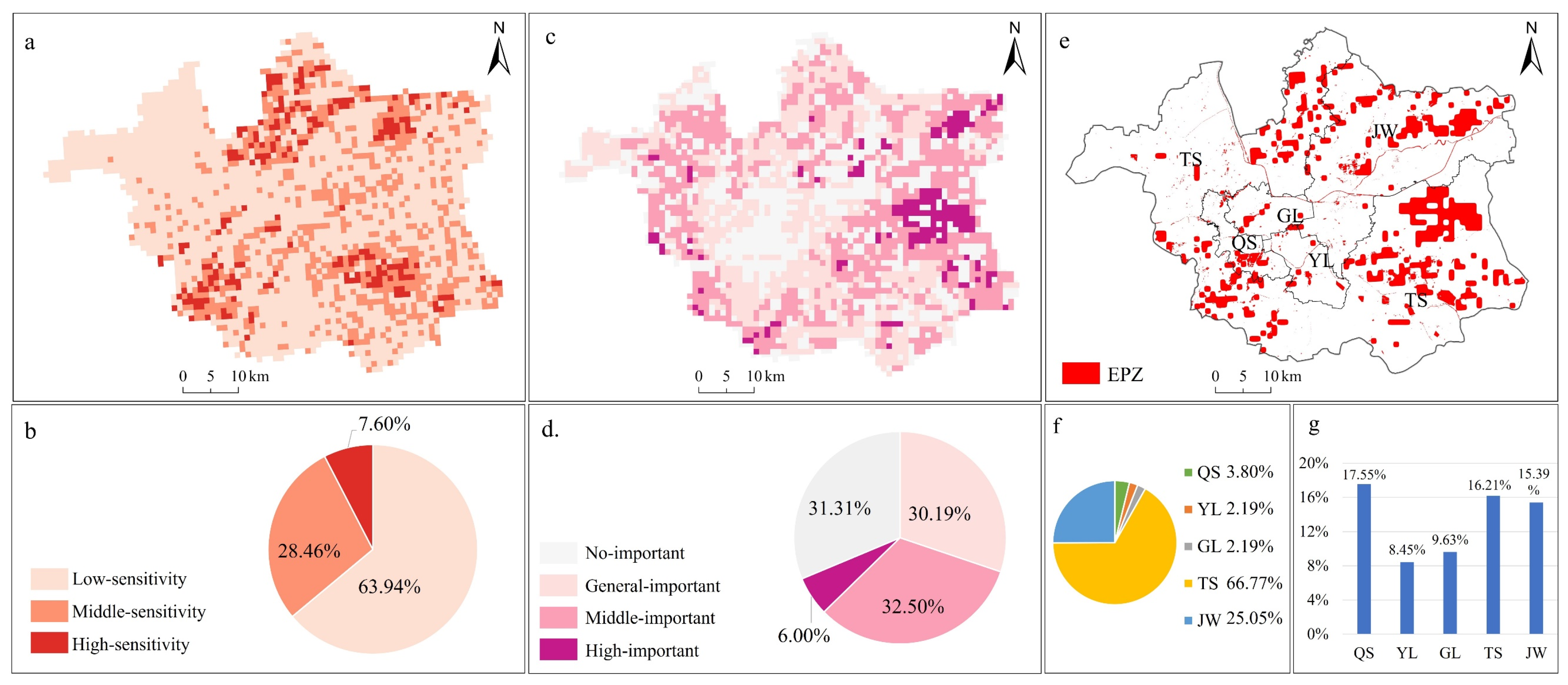
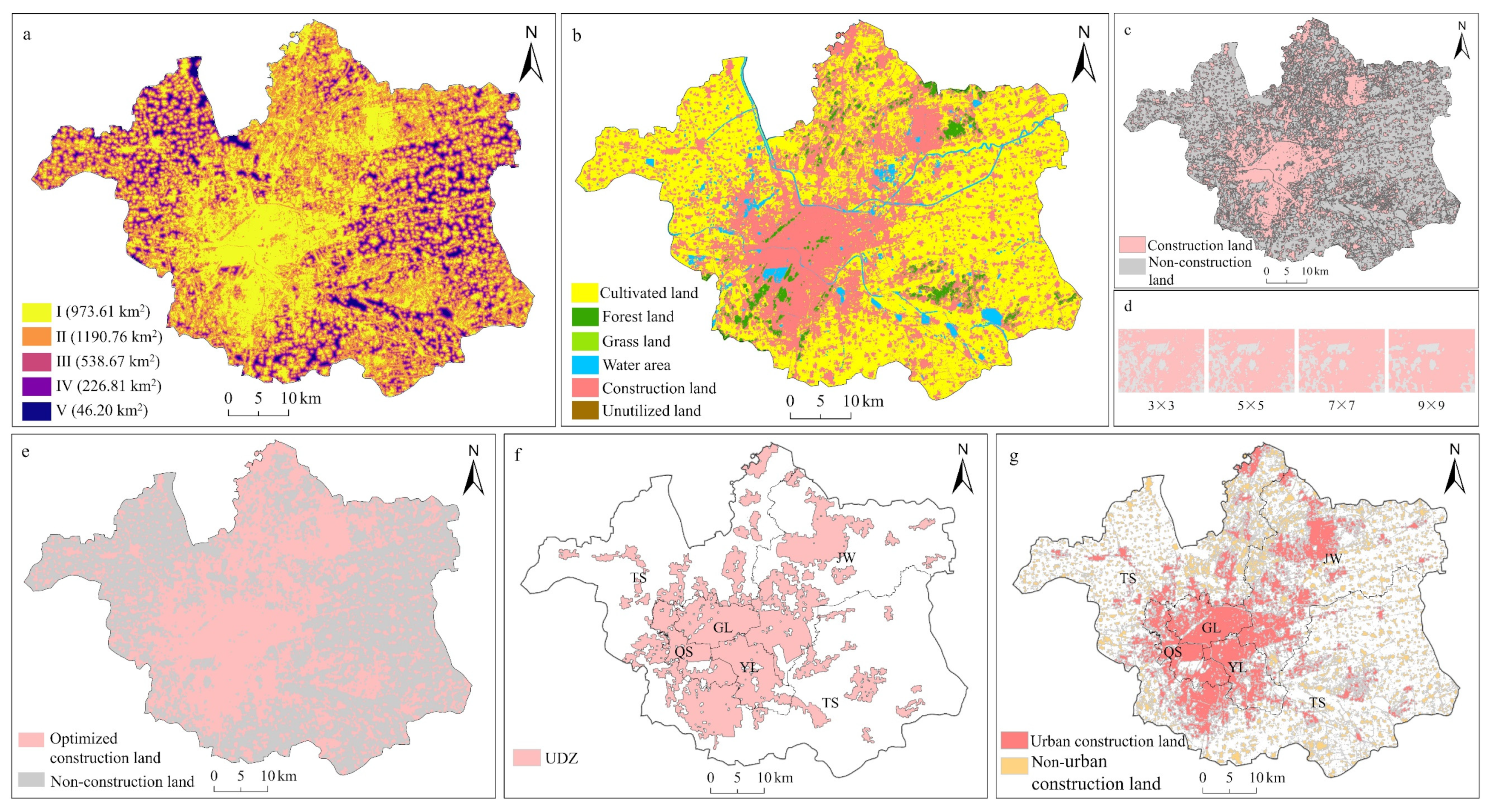
- Individually delineated territorial spatial functional zones in Xuzhou were obtained; the scale of the FPZ was 1189.33 km2, the scale of the EPZ was 461.34 km2, the scale of UDZ was 897.76 km2, and the urban construction land in the UDZ was 698.69 km2.
- (2)
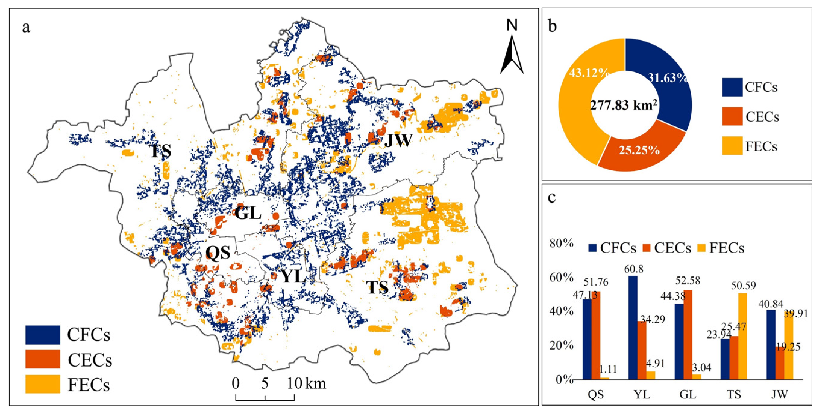
- The area of territorial space functional zone conflicts in Xuzhou was 277.83 km2. The area of FECs was 119.80 km2, and its high-kernel-density areas were mainly distributed in Jiawang and Tongshan districts. The area of CFCs was 87.88 km2, and its high-kernel-density areas were distributed in five districts. The area of CECs was 70.15 km2, and its high-kernel-density areas were distributed only in Tongshan District. Jawang District had the most serious conflicts, and the conflicts were mainly CFCs and FECs. Quanshan District had relatively weaker conflicts, and the conflicts were CFCs and CECs.
- (3)
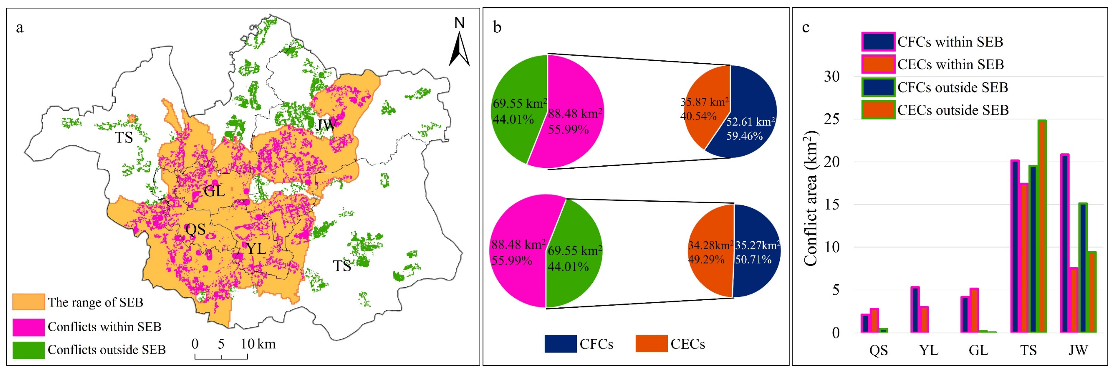
- The prediction obtained the AP (i.e., CP) corresponding to the SEB in 2035 of 1499.46 yuan/m2. The spatial scope of the SEB covered all of Yunlong District, most of Gulou and Quanshan Districts, and some parts of Jawang and Tongshan Districts.
- (4)
- The land with CFCs and CECs within the SEB was retained as urban construction land, while that with these two conflict types outside the SEB was retained as an FPZ and an EPZ, respectively. The land with FECs was retained as an FPZ in accordance with the principle of food security priority and, at the same time, it was used as an ECZ. The areas of FPZ, EPZ, and the urban construction land in UDZ after optimization were 1136.72 km2, 295.15 km2, and 632.50 km2, respectively.
Author Contributions
Funding
Data Availability Statement
Acknowledgments
Conflicts of Interest
Appendix A


References
- Liu, C.; Hao, M.; Tang, N.; Liang, X.; Cheng, L. Threshold effects of vegetation cover on production-living-ecological functions coordination in Xiangyang City, China. Environ. Monit. Assess. 2024, 196, 1202. [Google Scholar] [CrossRef] [PubMed]
- Li, S.; Zhao, X.; Pu, J.; Miao, P.; Wang, Q.; Tan, K. Optimize and control territorial spatial functional areas to improve the ecological stability and total environment in karst areas of Southwest China. Land Use Policy 2021, 100, 104940. [Google Scholar] [CrossRef]
- Chakraborty, S.; Maity, I.; Dadashpoor, H.; Novotnẏ, J.; Banerji, S. Building in or out? Examining urban expansion patterns and land use efficiency across the global sample of 466 cities with million+ inhabitants. Habitat Int. 2022, 120, 102503. [Google Scholar] [CrossRef]
- Zhang, Z.; Zhao, W.; Liu, Y.; Pereira, P. Impacts of urbanisation on vegetation dynamics in Chinese cities. Environ. Impact Assess. Rev. 2023, 103, 107227. [Google Scholar] [CrossRef]
- van Vliet, J. Direct and indirect loss of natural area from urban expansion. Nat. Sustain. 2019, 2, 755–763. [Google Scholar] [CrossRef]
- Liu, X.; Li, X.; Zhang, Y.; Wang, Y.; Chen, J.; Geng, Y. Spatiotemporal evolution and relationship between construction land expansion and territorial space conflicts at the county level in Jiangsu Province. Ecol. Indic. 2023, 154, 110662. [Google Scholar] [CrossRef]
- Baldini, C.; Marasas, M.E.; Tittonell, P.; Drozd, A.A. Urban, periurban and horticultural landscapes-Conflict and sustainable planning in La Plata district, Argentina. Land Use Policy 2022, 117, 106120. [Google Scholar] [CrossRef]
- Zong, S.; Xu, S.; Huang, J.; Ren, Y.; Song, C. Distribution patterns and driving mechanisms of land use spatial conflicts: Empirical analysis from counties in China. Habitat Int. 2025, 156, 103268. [Google Scholar] [CrossRef]
- Li, S.; Wenzhan, A.; Zhang, J.; Gan, M.; Wang, K.; Ding, L.; Li, W. Optimizing limit lines in urban-rural transitional areas: Unveiling the spatial dynamics of trade-offs and synergies among land use functions. Habitat Int. 2023, 140, 102907. [Google Scholar] [CrossRef]
- Wang, G.; Yang, D.; Xia, F.; Zhong, R.; Xiong, C. Three Types of Spatial Function Zoning in Key Ecological Function Areas Based on Ecological and Economic Coordinated Development: A Case Study of Tacheng Basin, China. Chin. Geogr. Sci. 2019, 29, 689–699. [Google Scholar] [CrossRef]
- Yang, Y.; Liu, Y.; Zhu, C.; Chen, X.; Rong, Y.; Zhang, J.; Huang, B.; Bai, L.; Chen, Q.; Su, Y.; et al. Spatial identification and interactive analysis of urban production—Living—Ecological spaces using point of interest data and a two-level scoring evaluation model. Land 2022, 11, 1814. [Google Scholar] [CrossRef]
- Deng, Y.; Yang, R. Influence mechanism of production-living-ecological space changes in the urbanization process of Guangdong Province, China. Land 2021, 10, 1357. [Google Scholar] [CrossRef]
- Zhang, Z.; Li, J. Spatial suitability and multi-scenarios for land use: Simulation and policy insights from the production-living-ecological perspective. Land Use Policy 2022, 119, 106219. [Google Scholar] [CrossRef]
- Jia, J.; Jiang, E.; Tian, S.; Qu, B.; Li, J.; Hao, L.; Liu, C.; Jing, Y. Land-use transformation and its eco-environmental effects of production–living–ecological space based on the county level in the Yelow River Basin. Land 2025, 14, 427. [Google Scholar] [CrossRef]
- Zhang, R.; Tian, G.; Borowiak, K.; Lisiak-Zielińska, M.; Lei, Y.; Yang, M.; Tian, Y.; Zhao, R.; Yan, J.; Mu, B. Measuring the evolutionary game process among three functional space types at the county scale in Henan Province, China. Cities 2023, 142, 104560. [Google Scholar] [CrossRef]
- Shi, Z.; Deng, W.; Zhang, S. Spatio-temporal pattern changes of land space in Hengduan Mountains during 1990–2015. J. Geogr. Sci. 2018, 28, 529–542. [Google Scholar] [CrossRef]
- Niu, J.; Jin, G.; Zhang, L. Territorial spatial zoning based on suitability evaluation and its impact on ecosystem services in Ezhou city. J. Geogr. Sci. 2023, 33, 2278–2294. [Google Scholar] [CrossRef]
- Qu, Y.; Zhang, Y.; Wang, S.; Shang, R.; Zong, H.; Zhan, L. Coordinated development of land multi-function space: An analytical framework for matching the supply of resources and environment with the use of land space for ecological protection, agricultural production and urban construction. J. Geogr. Sci. 2023, 33, 311–339. [Google Scholar] [CrossRef]
- Luan, C.; Liu, R.; Li, Y.; Zhang, Q. Comparison of various models for multi-scenario simulation of land use/land cover to predict ecosystem service value: A case study of Harbin-Changchun Urban Agglomeration, China. J. Clean. Prod. 2024, 478, 144012. [Google Scholar] [CrossRef]
- Yao, Z.; Jiang, C.; Shan-shan, F. Effects of urban growth boundaries on urban spatial structural and ecological functional optimization in the Jining Metropolitan Area, China. Land Use Policy 2022, 117, 106113. [Google Scholar] [CrossRef]
- Liu, D.; Tang, W.; Liu, Y.; Zhao, X.; He, J. Optimal rural land use allocation in central China: Linking the effect of spatiotemporal patterns and policy interventions. Appl. Geogr. 2017, 86, 165–182. [Google Scholar] [CrossRef]
- Chen, L.; Zhang, A. Identification of land use conflicts and dynamic response analysis of Natural-Social factors in rapidly urbanizing areas—A case study of urban agglomeration in the middle reaches of Yangtze River. Ecol. Indic. 2024, 161, 112009. [Google Scholar] [CrossRef]
- Jiang, S.; Meng, J.; Zhu, L. Spatial and temporal analyses of potential land use conflict under the constraints of water resources in the middle reaches of the Heihe River. Land Use Policy 2020, 97, 104773. [Google Scholar] [CrossRef]
- Hjalager, A.-M. Land-use conflicts in coastal tourism and the quest for governance innovations. Land Use Policy 2020, 94, 104566. [Google Scholar] [CrossRef]
- Karimi, A.; Brown, G. Assessing multiple approaches for modelling land-use conflict potential from participatory mapping data. Land Use Policy 2017, 67, 253–267. [Google Scholar] [CrossRef]
- Fienitz, M.; Siebert, R. “It is a total drama”: Land use conflicts in local land use actors’ experience. Land 2022, 11, 602. [Google Scholar] [CrossRef]
- Hong, W.; Guo, R.; Wang, W. A diagrammatic method for the identification and resolution of urban spatial conflicts. J. Environ. Manag. 2022, 316, 115297. [Google Scholar] [CrossRef]
- Qu, Y.; Wang, S.; Tian, Y.; Jiang, G.; Zhou, T.; Meng, L. Territorial spatial planning for regional high-quality development-An analytical framework for the identification, mediation and transmission of potential land utilization conflicts in the Yellow River Delta. Land Use Policy 2023, 125, 106462. [Google Scholar] [CrossRef]
- Nyuykighanse, N.E.; Yenlajai, B.J.; Fru, C.F.; Kimengsi, J.N. Land use conflicts and planning implications: Insights from Kumbo, Cameroon. J. Geogr. Environ. Earth Sci. Int. 2023, 27, 28–39. [Google Scholar] [CrossRef]
- Zhang, B.; Zhai, J.; Zhai, B.; Qu, Y. Understanding the “conflict-coordination” theoretical model of regional land use transitions: Empirical evidence from the interconversion between cropland and rural settlements in the lower yellow river, China. Habitat Int. 2024, 148, 103072. [Google Scholar] [CrossRef]
- Ma, W.; Jiang, G.; Chen, Y.; Qu, Y.; Zhou, T.; Li, W. How feasible is regional integration for reconciling land use conflicts across the urban-rural interface? Evidence from Beijing-Tianjin-Hebei metropolitan region in China. Land Use Policy 2020, 92, 104433. [Google Scholar] [CrossRef]
- Liang, Y.; Chai, D.; Zhou, X.; Ning, Y. Potential conflict diagnosis, simulation optimization and coordination of production-living-ecological space in gully areas of the Loess Plateau, China. Environ. Dev. 2024, 52, 101099. [Google Scholar] [CrossRef]
- Zhao, Y.; Liu, J.; Zhang, J.; Zhang, X.; Li, H.; Gao, F.; Zhan, Y. Spatial Identification and Evaluation of Land Use Multifunctions and Their Interrelationships Improve Territorial Space Zoning Management in Harbin, China. Land 2024, 13, 1092. [Google Scholar] [CrossRef]
- Li, X.; Wei, X.; Lang, W.; Wang, T.; Jiang, D.; Chen, X. The theoretical proposition on urban sprawl and its control strategy selection based on land price equilibrium. China Land Sci. 2018, 32, 6–13. [Google Scholar]
- Li, X.; Zhan, M.; Li, F.; Yan, J.; Xiao, Y. Research on the ideas and methods of conducting technology for implementation of territory spatial planning. J. Nat. Resour. 2022, 37, 2789–2802. [Google Scholar]
- Wu, T. A discussion on urban planning in spatial planning system. City Plan. Rev. 2019, 43, 9–17. [Google Scholar]
- Li, Y.; Zhao, J.; Zhang, S.; Zhang, G.; Zhou, L. Qualitative-quantitative identification and functional zoning analysis of production-living-ecological space: A case study of Urban Agglomeration in Central Yunnan, China. Environ. Monit. Assess. 2023, 195, 1163. [Google Scholar] [CrossRef]
- Liu, X.; Li, X.; Yang, J.; Fan, H.; Zhang, J.; Zhang, Y. How to resolve the conflicts of urban functional space in planning: A perspective of urban moderate boundary. Ecol. Indic. 2022, 144, 109495. [Google Scholar] [CrossRef]
- Cheng, J.; Li, X.; Geng, Y.; Wang, Z.; Li, T.; Fan, Q. Theoretical analysis and empirical study of urban expansion based on the marginal principle. Land 2023, 12, 1779. [Google Scholar] [CrossRef]
- Liu, X.; Li, X.; Wei, X.; Jiang, D.; Li, F.; Shen, C. Study on Fusion Demarcation of Urban Development Boundary Based on MCR and CA Model: A Case Study of Xuzhou City. China Land Sci. 2020, 34, 8–17. [Google Scholar]
- Lin, Y.; Qin, Y.; Yang, Y.; Zhu, H. Can price regulation increase land-use intensity? Evidence from China’s industrial land market. Reg. Sci. Urban Econ. 2020, 81, 103501. [Google Scholar] [CrossRef]
- Qian, F.; Jiao, S.; Yu, Y.; Wang, X.; Shao, T. Cultivated Land Quality Assessment and Obstacle Factors Diagnosis in Changtu County, Northeast China. Land Degrad. Dev. 2024, 35, 5065–5077. [Google Scholar] [CrossRef]
- Duan, D.; Sun, X.; Liang, S.; Sun, J.; Fan, L.; Chen, H.; Xia, L.; Zhao, F.; Yang, W.; Yang, P. Spatiotemporal Patterns of Cultivated Land Quality Integrated with Multi-Source Remote Sensing: A Case Study of Guangzhou, China. Remote Sens. 2022, 14, 1250. [Google Scholar] [CrossRef]
- Song, W.; Zhang, H.; Zhao, R.; Wu, K.; Li, X.; Niu, B.; Li, J. Study on cultivated land quality evaluation from the perspective of farmland ecosystems. Ecol. Indic. 2022, 139, 108959. [Google Scholar] [CrossRef]
- Gong, H.; Zhao, Z.; Chang, L.; Li, G.; Li, Y.; Li, Y. Spatiotemporal Patterns in and Key Influences on Cultivated-Land Multi-Functionality in Northeast China’s Black-Soil Region. Land 2022, 11, 1101. [Google Scholar] [CrossRef]
- Jing, X.; Tao, S.; Hu, H.; Sun, M.; Wang, M. Spatio-temporal evaluation of ecological security of cultivated land in China based on DPSIR-entropy weight TOPSIS model and analysis of obstacle factors. Ecol. Indic. 2024, 166, 112579. [Google Scholar] [CrossRef]
- Liu, X.; Li, X.; Chen, X.; Zhang, Y.; Li, G.; Shen, C. Coupling measurement and spatial conflict diagnosis between urbanization and ecological environment in Jiangsu Province of China. Trans. Chin. Soc. Agric. Eng. 2023, 39, 238–248. [Google Scholar] [CrossRef]
- Yi, K.; Zhang, J.; Wang, Y.; Zhang, S.; Liang, S.; Wu, G. Response of erosion sensitivity to land use change in populated areas: A case study of the middle and lower reaches of Yangtze River. Environ. Dev. Sustain. 2024. [Google Scholar] [CrossRef]
- Chen, M.; Xu, X.; Tan, Y.; Lin, Y. Assessing ecological vulnerability and resilience-sensitivity under rapid urbanization in China’s Jiangsu province. Ecol. Indic. 2024, 167, 112607. [Google Scholar] [CrossRef]
- Chen, Z.; Liu, Y.S.; Feng, W.; Li, Y.; Li, L. Study on spatial tropism distribution of rural settlements in the Loess Hilly and Gully Region based on natural factors and traffic accessibility. J. Rural Stud. 2022, 93, 441–448. [Google Scholar] [CrossRef]
- Zhang, H.; Li, H.; Zhang, J.; Wang, J.; Wang, G.; Shan, Y.; Zheng, H. Simulation of wetland distribution in the Yellow River Basin based on an improved Markov-FLUS model. Environ. Res. Lett. 2024, 19, 104001. [Google Scholar] [CrossRef]
- Li, L.; Huang, X.; Wu, D.; Yang, H. Construction of ecological security pattern adapting to future land use change in Pearl River Delta, China. Appl. Geogr. 2023, 154, 102946. [Google Scholar] [CrossRef]
- Liu, Y.; Zhang, Y.; Zhang, Y.; Liu, Y.; Wang, H.; Liu, Y. Conflicts between three land management red lines in Wuhan City: Spatial patterns and driving factors. Prog. Geogr. 2018, 37, 1672–1681. [Google Scholar] [CrossRef]
- Wang, K.; Zhang, F.; Xu, R.; Miao, Z.; Cheng, Y.; Sun, H. Spatiotemporal pattern evolution and influencing factors of green innovation efficiency: A China’s city level analysis. Ecol. Indic. 2023, 146, 109901. [Google Scholar] [CrossRef]
- Su, H.; Wu, C. Analysis of the lnfluencing factors of the Cultivated Land Resources Value in Black Soil Region Based on the Production-Living-Ecological Functions: A Case Study in Keshan County, Heilongiiang Province. China Land Sci. 2020, 34, 77–85. [Google Scholar] [CrossRef]
- Xie, G.; Zhang, C.; Zhen, L.; Zhang, L. Dynamic changes in the value of China’s ecosystem services. Ecosyst. Serv. 2017, 26, 146–154. [Google Scholar] [CrossRef]
- Chuai, X.; Huang, X.; Wu, C.; Li, J.; Lu, Q.; Qi, X.; Zhang, M.; Zuo, T.; Lu, J. Land use and ecosystems services value changes and ecological land management in coastal Jiangsu, China. Habitat Int. 2016, 57, 164–174. [Google Scholar] [CrossRef]
- Ji, H.; Li, X.; Geng, Y.; Chen, X.; Wang, Y.; Cheng, J.; Chen, Z. Delineation of Urban Development Boundary and Carbon Emission Effects in Xuzhou City, China. Land 2023, 12, 1819. [Google Scholar] [CrossRef]
- Zhang, T.; Liu, S.; Wang, M.; Hu, H.; Hu, Y. Integrating dual evaluation and FLUS model for land use simulation and urban growth boundary delineation in production-living-ecology spaces: A case study of Central Harbin, China. Geocarto Int. 2024, 39, 2392881. [Google Scholar] [CrossRef]
- Li, J.; Guldmann, J.-M.; Gong, J.; Su, H. Urban growth boundaries optimization under low-carbon development: Combining multi-objective programming and patch cellular automata models. J. Environ. Manag. 2023, 340, 117934. [Google Scholar] [CrossRef]
- Tan, X.; Yu, H.; Zhong, X.; Wang, W. Delineating urban growth boundaries by coupling urban interactions and ecological conservation. Cities 2024, 145, 104712. [Google Scholar] [CrossRef]
- Fan, Y.; Jin, X.; Gan, L.; Yang, Q.; Wang, L.; Lyu, L.; Li, Y. Exploring an integrated framework for “dynamic-mechanism-clustering” of multiple cultivated land functions in the Yangtze River Delta region. Appl. Geogr. 2023, 159, 103061. [Google Scholar] [CrossRef]
- Zheng, M.; Wang, H.; Shang, Y.; Zheng, X. Identification and prediction of mixed-use functional areas supported by POI data in Jinan City of China. Sci. Rep. 2023, 13, 2913. [Google Scholar] [CrossRef]
- Lu, Q.; Yao, S. From Urban–Rural Division to Urban–Rural Integration: A Systematic Cost Explanation and Chengdu’s Experience. China World Econ. 2018, 26, 86–105. [Google Scholar] [CrossRef]
- Liu, Y.; Zang, Y.; Yang, Y. China’s rural revitalization and development: Theory, technology and management. J. Geogr. Sci. 2020, 30, 1923–1942. [Google Scholar] [CrossRef]
- Ma, L.; Liu, S.; Fang, F.; Che, X.; Chen, M. Evaluation of urban-rural difference and integration based on quality of life. Sustain. Cities Soc. 2020, 54, 101877. [Google Scholar] [CrossRef]
- Shen, Z.; Hong, T.; Blancard, S.; Bai, K. Digital financial inclusion and green growth: Analysis of Chinese agriculture. Appl. Econ. 2024, 56, 5555–5573. [Google Scholar] [CrossRef]






| Data Type | Data Sources | Instruction |
|---|---|---|
| Land use type | Resource and Environmental Science Data Platform (https://www.resdc.cn) accessed on 10 December 2023 | Raster data (30 m) |
| DEM | Geospatial Data Cloud (http://www.gscloud.cn) accessed on 10 December 2023 | Raster data (30 m) |
| Meteorological data (annual precipitation, annual average temperature, etc.) | Resource and Environmental Science Data Platform (https://www.resdc.cn) accessed on 10 December 2023 Meteorological Data Network (http://data.cma.cn/) accessed on 10 December 2023 | Raster data (1 km) |
| Normalized vegetation index (NDVI) | Resource and Environmental Science Data Platform (https://www.resdc.cn) accessed on 15 December 2023 | Raster data (1 km) |
| Vegetation net primary productivity (NPP) | Resource and Environmental Science Data Platform (https://www.resdc.cn) accessed on 15 December 2023 | Raster data (1 km) |
| Soil data | Chinese Soil Dataset based on the World Soil Database (HWSD) (v1.1) accessed on 1 November 2023 | Raster data (1 km) |
| Socio-economic spatial data (spatial distribution of GDP, population density) | Resource and Environmental Science Data Platform (https://www.resdc.cn) accessed on 1 November 2023 | Raster data (1 km) |
| Socio-economic statistics (population, food production, output, cropped area, etc.) | Xuzhou Statistical Yearbook Xuzhou National Economic and Social Development Statistics Bulletin | |
| Cultivated land attribute | Xuzhou Cultivated Land Classification and Grading Database | Non-public |
| Land price | Xuzhou Natural Resources and Planning Bureau (https://zrzy.jiangsu.gov.cn/xz/) accessed on 5 March 2024 China Land Value Information Service Platform (https://www.landvalue.com.cn/) accessed on 5 March 2024 | Partially public |
| Territorial spatial planning data | Xuzhou Natural Resources and Planning Bureau (https://zrzy.jiangsu.gov.cn/xz/) accessed on 5 March 2024 | Partially public |
| Indicators | Classification Standard | Weight | |||||
|---|---|---|---|---|---|---|---|
| 100 | 80 | 60 | 40 | 20 | |||
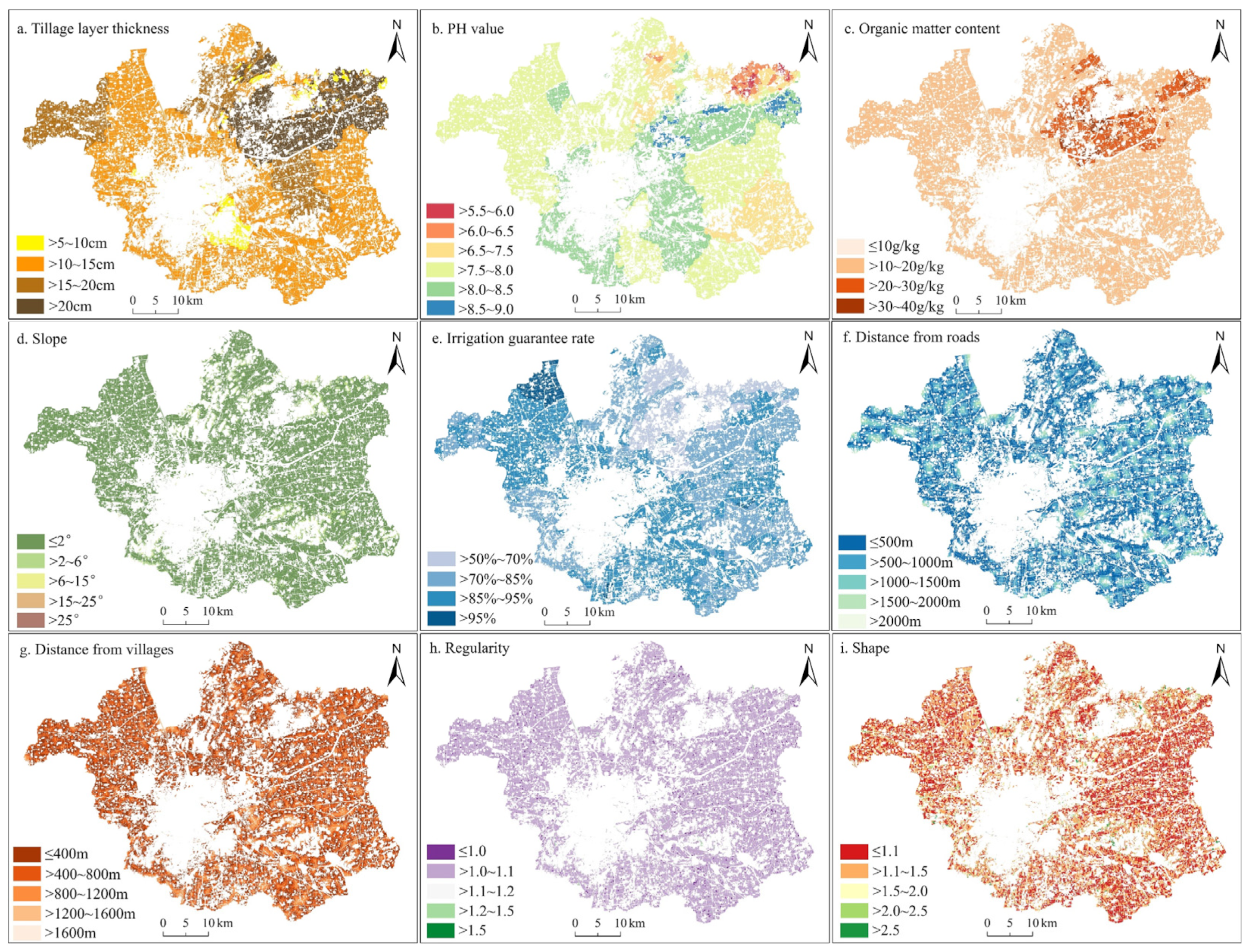
| NC | Tillage layer thickness (cm) | >20 | >15~20 | >10~15 | >5~10 | ≤5 | 0.17 |
| PH value | >6.5~7.5 | >6.0~6.5, >7.5~8.0 | >5.5~6.0, >8.0~8.5 | >5.0~5.5, >8.5~9.0 | ≤5.0, >9.0 | 0.06 | |
| Organic matter content (g/kg) | >40 | >30~40 | >20~30 | >10~20 | ≤10 | 0.14 | |
| Slope (°) | ≤2 | >2~6 | >6~15 | >15~25 | >25 | 0.08 | |
| Irrigation guarantee rate (%) | >95 | >85%~95 | >70%~85 | >50%~70 | ≤50 | 0.15 | |
| LC | Distance from roads (m) | 0~500 | >500~1000 | >1000~1500 | >1500~2000 | >2000 | 0.12 |
| Distance from villages (m) | 0~400 | >400~800 | >800~1200 | >1200~1600 | >1600 | 0.05 | |
| SL | Regularity | >1.5 | >1.2~1.5 | >1.1~1.2 | >1.0~1.1 | ≤1.0 | 0.05 |
| Shape | ≤1.1 | >1.1~1.5 | >1.5~2.0 | >2.0~2.5 | >2.5 | 0.11 | |
| Factors | Classification | Score | Weight | Factors | Classification | Score | Weight |
|---|---|---|---|---|---|---|---|
| Elevation | 0~60 | 5 | 0.15 | Distance from roads (m) | 0~500 | 5 | 0.14 |
| 60~120 | 4 | 500~1000 | 4 | ||||
| 120~180 | 3 | 1000~1500 | 3 | ||||
| 180~240 | 2 | 1500~2000 | 2 | ||||
| >240 | 1 | >2000 | 1 | ||||
| Slope | 0°~2° | 5 | 0.19 | Spatial distribution of GDP (100,000 yuan/km2) | ≤3000 | 1 | 0.18 |
| 2°~6° | 4 | 3000~8000 | 2 | ||||
| 6°~15° | 3 | 8000~15,000 | 3 | ||||
| 15°~25° | 2 | 15,000~30,000 | 4 | ||||
| >25° | 1 | >30,000 | 5 | ||||
| Distance from water area (m) | 0~1000 | 5 | 0.16 | Population density (Persons/km2) | ≤800 | 1 | 0.18 |
| 1000~2000 | 4 | 800~2800 | 2 | ||||
| 2000~3000 | 3 | 2800~5000 | 3 | ||||
| 3000~4000 | 2 | 5000~8400 | 4 | ||||
| >4000 | 1 | >8400 | 5 |
| Land Use Type | Cultivated Land | Forest Land | Grassland | Water Area | Construction Land | Unused Land | |
|---|---|---|---|---|---|---|---|
| sensitivity grade | Low sensitivity | 66.3374 | 0.0810 | 0.0013 | 1.7662 | 0.0007 | 31.8134 |
| Medium sensitivity | 61.5594 | 1.5277 | 0.0255 | 3.1111 | 0.0011 | 33.7752 | |
| High sensitivity | 44.7288 | 16.2689 | 0.4712 | 0.5523 | 0.0128 | 37.9662 | |
| ecosystem service importance grade | Not important | 55.8304 | 1.4178 | 0.0317 | 3.1634 | 0.0015 | 39.5551 |
| Generally important | 55.7884 | 3.4261 | 0.0983 | 2.1403 | 0.0037 | 38.5432 | |
| Middle importance | 76.1930 | 0.7757 | 0.0216 | 1.1309 | 0.0002 | 21.8785 | |
| Highly important | 80.6528 | 0.0832 | 0.0005 | 0.5280 | 0.0000 | 18.7355 | |
Disclaimer/Publisher’s Note: The statements, opinions and data contained in all publications are solely those of the individual author(s) and contributor(s) and not of MDPI and/or the editor(s). MDPI and/or the editor(s) disclaim responsibility for any injury to people or property resulting from any ideas, methods, instructions or products referred to in the content. |
© 2025 by the authors. Licensee MDPI, Basel, Switzerland. This article is an open access article distributed under the terms and conditions of the Creative Commons Attribution (CC BY) license (https://creativecommons.org/licenses/by/4.0/).
Share and Cite
Liu, X.; Li, X.; Li, P.; Geng, Y.; Chen, J.; Hu, G. Delineation of and Conflict Coordination in Municipal Territorial Space Functional Zones: A Case Study of Xuzhou, China. Land 2025, 14, 761. https://doi.org/10.3390/land14040761
Liu X, Li X, Li P, Geng Y, Chen J, Hu G. Delineation of and Conflict Coordination in Municipal Territorial Space Functional Zones: A Case Study of Xuzhou, China. Land. 2025; 14(4):761. https://doi.org/10.3390/land14040761
Chicago/Turabian StyleLiu, Xizhao, Xiaoshun Li, Panpan Li, Yiwei Geng, Jiangquan Chen, and Guoheng Hu. 2025. "Delineation of and Conflict Coordination in Municipal Territorial Space Functional Zones: A Case Study of Xuzhou, China" Land 14, no. 4: 761. https://doi.org/10.3390/land14040761
APA StyleLiu, X., Li, X., Li, P., Geng, Y., Chen, J., & Hu, G. (2025). Delineation of and Conflict Coordination in Municipal Territorial Space Functional Zones: A Case Study of Xuzhou, China. Land, 14(4), 761. https://doi.org/10.3390/land14040761


