Modeling Wetland Biomass and Aboveground Carbon: Influence of Plot Size and Data Treatment Using Remote Sensing and Random Forest
Abstract
1. Introduction
2. Data and Methods
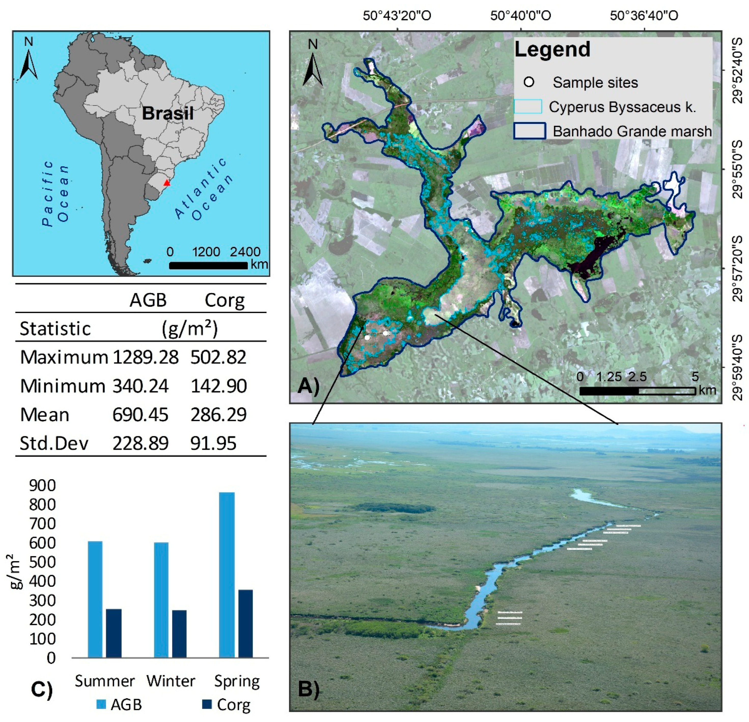
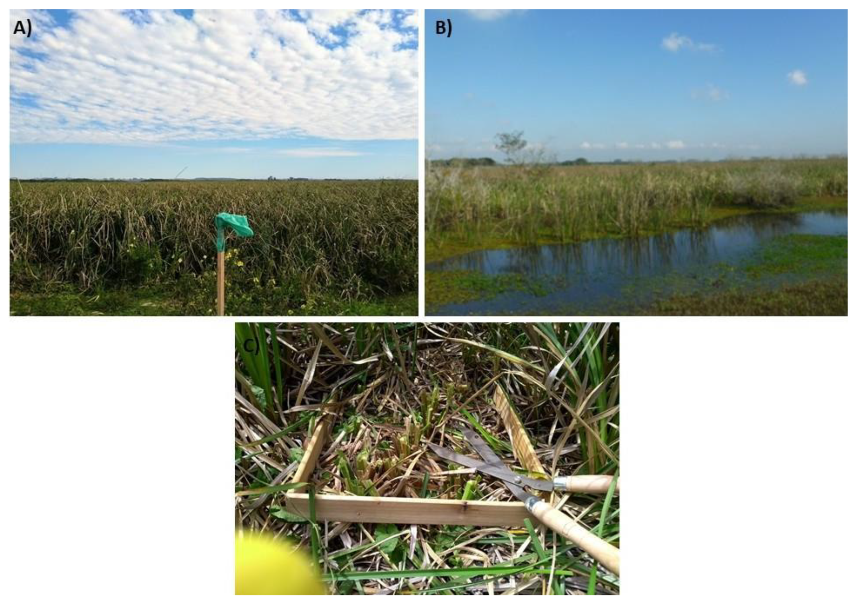
2.1. Study Area and Field Data Collection
2.2. Remote Sensing Datasets
2.3. Development of the Prediction Models
2.4. Evaluation of Models
3. Results
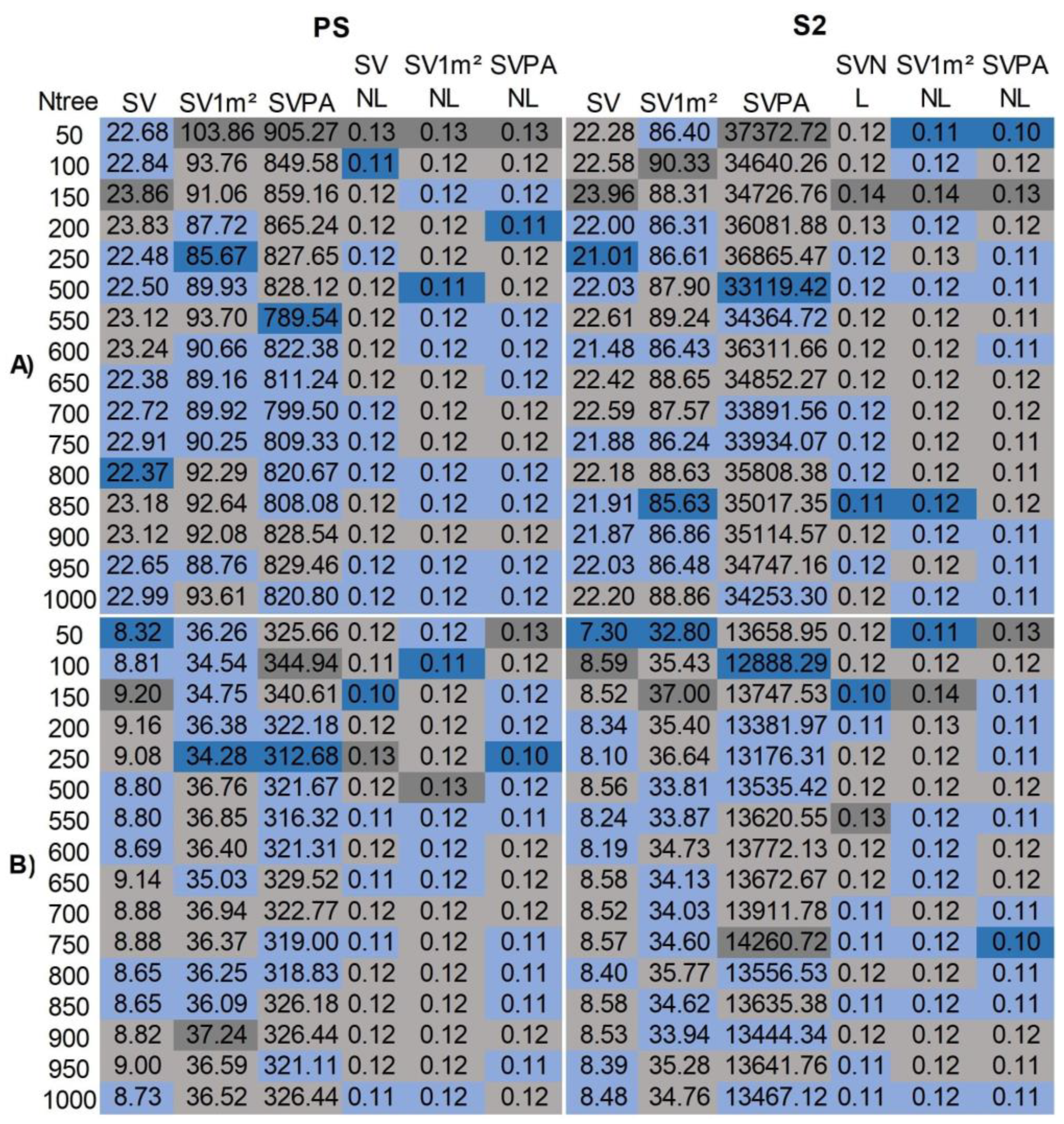
3.1. Optimization of Regression Model Parameters
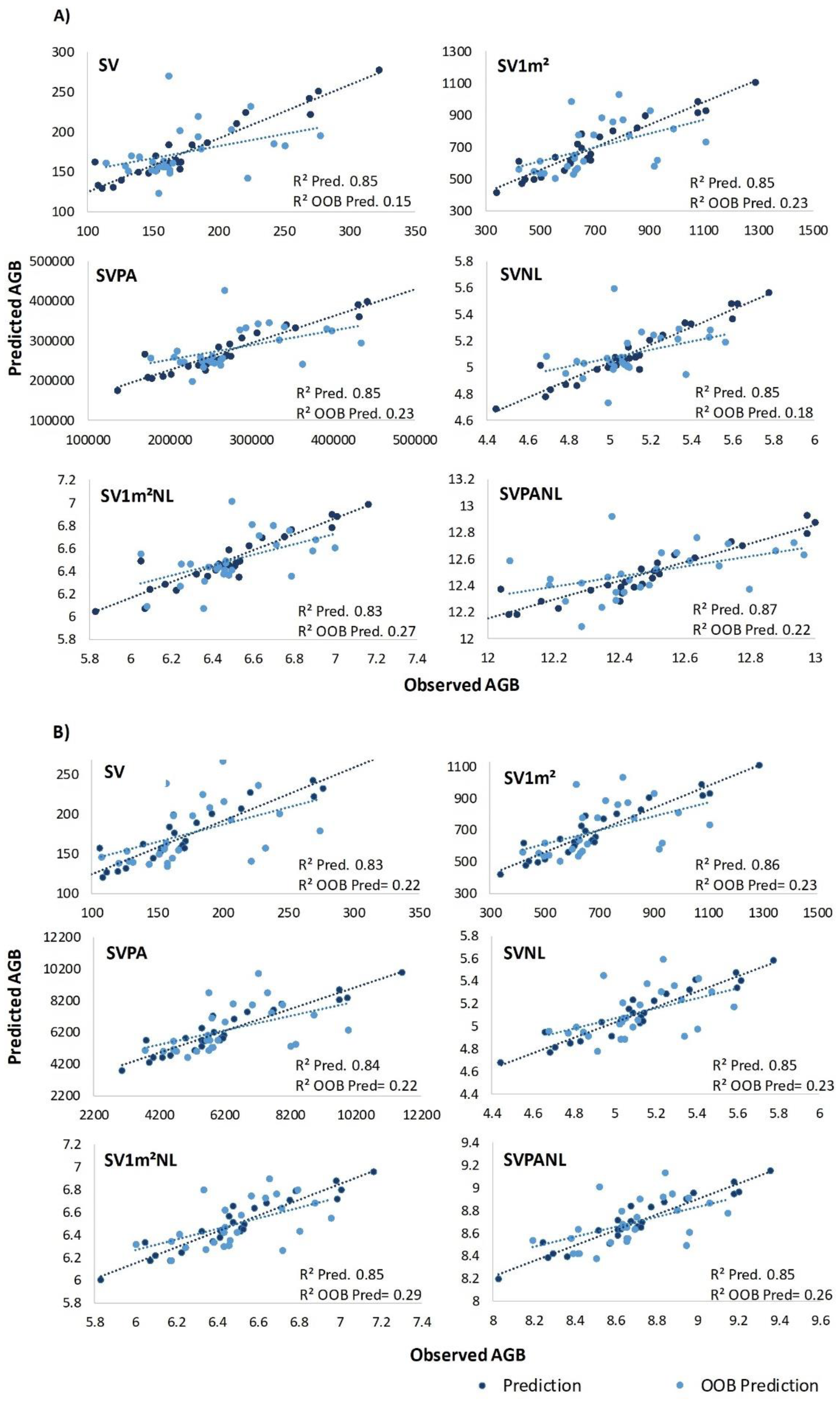
3.2. Predictive Performance of the RF Models
3.3. Importance of Predictor Variables
4. Discussion
4.1. AGB and Corg Estimation Accuracy and Efficiency of Sensors
4.2. The Effect of Treatments and Plot Size on Model Performance and Importance of Spectral Variables
5. Conclusions
- Regarding RF parameters, different Ntrees impacted model errors, notably in non-normalized treatments, enhancing RF model precision. Thus, optimized RF models provide more accurate estimates. OOB estimates served effectively for validation, with average prediction errors within the limits found in validation sets in reference studies. This result is useful in light of wetland data collection challenges.
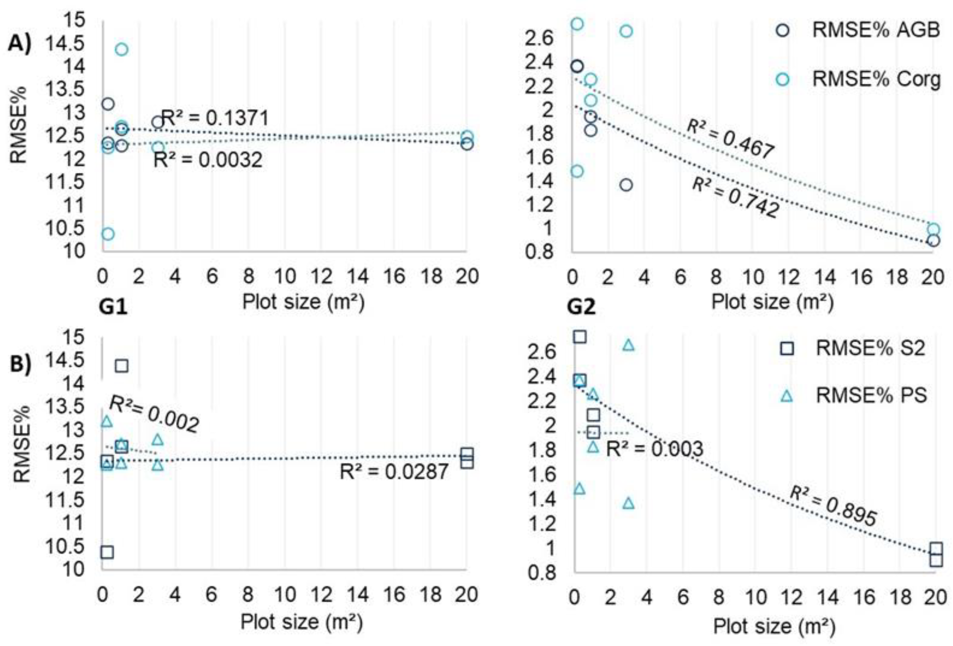
- Normalized sample data treatments enhanced RF model accuracy for AGB and Corg prediction. Estimation errors decrease as S2 model plot size increased, indicating smaller plots may compromise estimate reliability with S2.
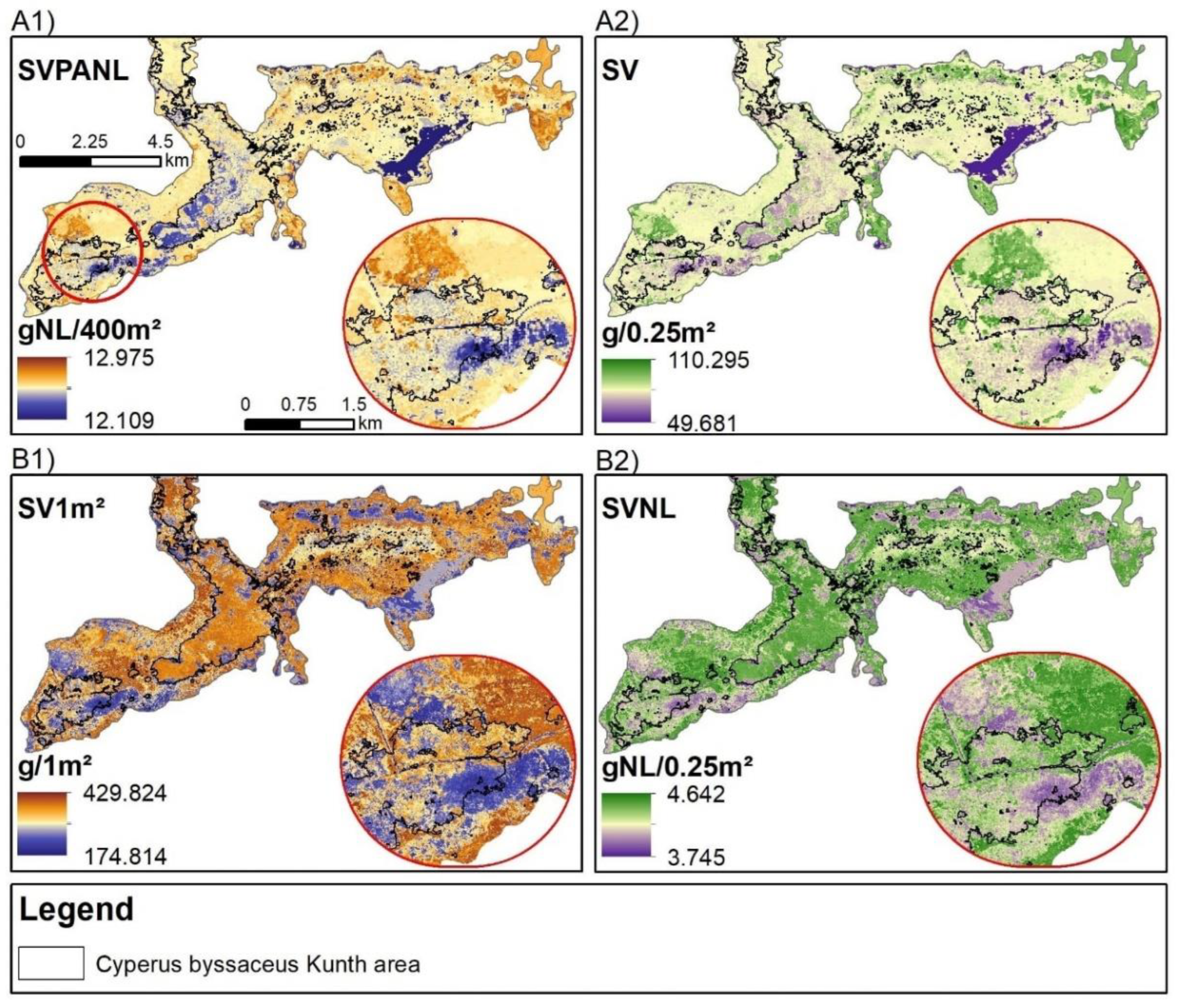
- Utilizing S2 and PS sensors underscored the value of medium spatial resolution satellite data for enhancing estimate accuracy and high-resolution data for delineating AGB and Corg spatial variability, respectively, in wetlands. Sensor performances were close; however, S2 was more efficient.
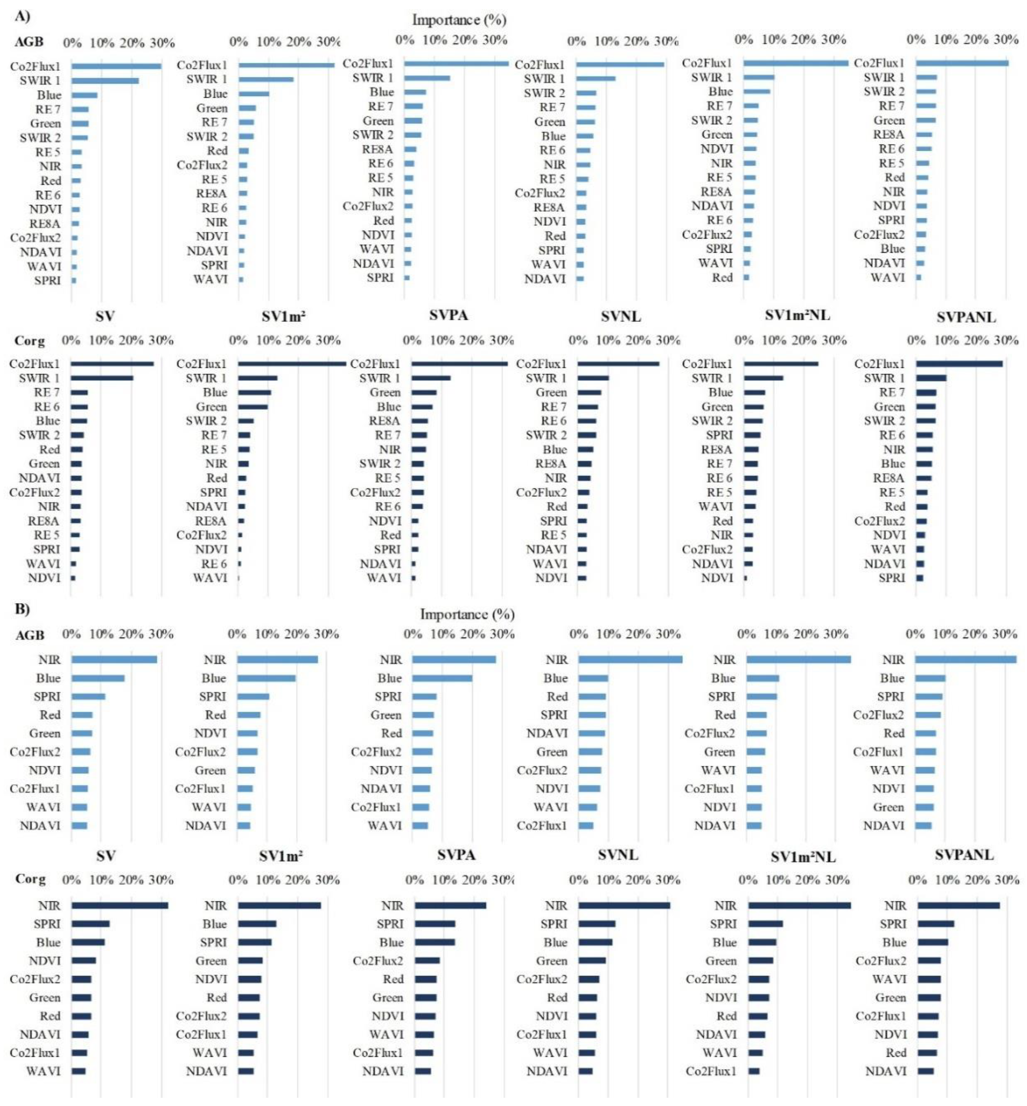
- The RF method, employing the combination of VI CO2Flux and S2’s SWIR, blue, green, and RE bands 6 and 7 as predictors, excelled in AGB and Corg prediction. Leveraging an ML algorithm with VI and bands indicative of carbon fluxes and biomass changes proved beneficial, and these predictors serve as spectral indicators of these ecological functions.
- In addition to optimizing the parameters of the RF model, optimizing the input set of AGB and Corg collected in the field, i.e., evaluating normalization and plot sizes, has contributed to more accurate estimates. This approach holds promise for improved monitoring of the ecological processes of AGB and Corg storage in wetlands and for contributing to the understanding of these ecosystems as carbon sinks, vital for offsetting emissions and meeting national and global GHG reduction targets.
- We encourage future work that compares the effects of different plot sizes, sample data normalization methods, sensors, and VIs in RF models and other ML approaches on the accuracy of AGB and Corg estimates in marshes, as well as in other wetlands with emergent herbaceous vegetation, such as salt marshes and peatlands. This will contribute to the continued advancement of knowledge on improving the modeling of AGB and Corg in wetlands.
Supplementary Materials
Author Contributions
Funding
Data Availability Statement
Conflicts of Interest
References
- Barbier, E.B.; Hacker, S.D.; Kennedy, C.; Koch, E.W.; Stier, A.C.; Silliman, B.R. The Value of Estuarine and Coastal Ecosystem Services. Ecol. Monogr. 2011, 81, 169–193. [Google Scholar] [CrossRef]
- Hiraishi, T.; Krug, T.; Tanabe, K.; Srivastava, N.; Baasansuren, J.; Fukuda, M.; Troxler, T.G. 2013 Supplement to the 2006 IPCC Guidelines for National Greenhouse Gas Inventories: Wetlands; IPCC: Interlaken, Switzerland, 2014; Available online: https://tinyurl.com/5c4xm8rp (accessed on 1 February 2025).
- Webb, E.L.; Friess, D.A.; Krauss, K.W.; Cahoon, D.R.; Guntenspergen, G.R.; Phelps, J. A Global Standard for Monitoring Coastal Wetland Vulnerability to Accelerated Sea-Level Rise. Nat. Clim. Chang. 2013, 3, 458–465. [Google Scholar] [CrossRef]
- Rice, J.; Seixas, C.; Elena, M.; Bedoya, M.; Valderrama, N.; Anderson, C. Resumen Para Los Responsables de La Formulación de Políticas Del Informe de Evaluación Regional Sobre Diversidad Biológica y Servicios de Los Ecosistemas Para Las Américas de La Plataforma Intergubernamental Científico-Normativa Sobre Diversidad Biológica; Plataforma Intergubernamental Científico-normativa sobre Diversidad Biológica y Servicios de los Ecosistemas: Medellín, Colombia, 2018; Volume 34, Available online: https://tinyurl.com/4seyyrds (accessed on 1 February 2025).
- Poulter, B.; Fluet-Chouinard, E.; Hugelius, G.; Koven, C.; Fatoyinbo, L.; Page, S.E.; Rosentreter, J.A.; Smart, L.S.; Taillie, P.J.; Thomas, N.; et al. A Review of Global Wetland Carbon Stocks and Management Challenges. In Wetland Carbon and Environmental Management; Krauss, K.W., Zhu, Z., Stagg, C.L., Eds.; Geophysical Monograph Series; Wiley: Hoboken, NJ, USA, 2021; pp. 1–20. ISBN 978-1-119-63928-2. [Google Scholar] [CrossRef]
- Byrd, K.B.; Ballanti, L.; Thomas, N.; Nguyen, D.; Holmquist, J.R.; Simard, M.; Windham-Myers, L. A Remote Sensing-Based Model of Tidal Marsh Aboveground Carbon Stocks for the Conterminous United States. ISPRS J. Photogramm. Remote Sens. 2018, 139, 255–271. [Google Scholar] [CrossRef]
- Ren, Y.; Mao, D.; Li, X.; Wang, Z.; Xi, Y.; Feng, K. Aboveground Biomass of Marshes in Northeast China: Spatial Pattern and Annual Changes Responding to Climate Change. Front. Ecol. Evol. 2022, 10, 1043811. [Google Scholar] [CrossRef]
- Dronova, I.; Taddeo, S.; Hemes, K.S.; Knox, S.H.; Valach, A.; Oikawa, P.Y.; Kasak, K.; Baldocchi, D.D. Remotely Sensed Phenological Heterogeneity of Restored Wetlands: Linking Vegetation Structure and Function. Agric. For. Meteorol. 2021, 296, 108215. [Google Scholar] [CrossRef]
- Campbell, A.D.; Temilola Fatoyinbo, L.; Charles, S.; Bourgeau-Chavez, L.L. A Review of Carbon Monitoring in Wet Carbon Systems Using Remote Sensing. Environ. Res. Lett. 2022, 17, 025009. [Google Scholar] [CrossRef]
- Requena-Mullor, J.M.; Reyes, A.; Escribano, P.; Cabello, J. Assessment of Ecosystem Functioning from Space: Advancements in the Habitats Directive Implementation. Ecol. Indic. 2018, 89, 893–902. [Google Scholar] [CrossRef]
- Cabello, J.; Fernández, N.; Alcaraz-Segura, D.; Oyonarte, C.; Piñeiro, G.; Altesor, A.; Delibes, M.; Paruelo, J.M. The Ecosystem Functioning Dimension in Conservation: Insights from Remote Sensing. Biodivers. Conserv. 2012, 21, 3287–3305. [Google Scholar] [CrossRef]
- Alcaraz-Segura, D.; Lomba, A.; Sousa-Silva, R.; Nieto-Lugilde, D.; Alves, P.; Georges, D.; Vicente, J.R.; Honrado, J.P. Potential of Satellite-Derived Ecosystem Functional Attributes to Anticipate Species Range Shifts. Int. J. Appl. Earth Obs. Geoinf. 2017, 57, 86–92. [Google Scholar] [CrossRef]
- Miller, G.J.; Morris, J.T.; Wang, C. Estimating Aboveground Biomass and Its Spatial Distribution in Coastal Wetlands Utilizing Planet Multispectral Imagery. Remote Sens. 2019, 11, 2020. [Google Scholar] [CrossRef]
- Warwick-Champion, E.; Davies, K.P.; Barber, P.; Hardy, N.; Bruce, E. Characterising the Aboveground Carbon Content of Saltmarsh in Jervis Bay, NSW, Using ArborCam and PlanetScope. Remote Sens. 2022, 14, 1782. [Google Scholar] [CrossRef]
- Zhao, Y.; Mao, D.; Zhang, D.; Wang, Z.; Du, B.; Yan, H.; Qiu, Z.; Feng, K.; Wang, J.; Jia, M. Mapping Phragmites australis Aboveground Biomass in the Momoge Wetland Ramsar Site Based on Sentinel-1/2 Images. Remote Sens. 2022, 14, 694. [Google Scholar] [CrossRef]
- Li, C.; Zhou, L.; Xu, W. Estimating Aboveground Biomass Using Sentinel-2 MSI Data and Ensemble Algorithms for Grassland in the Shengjin Lake Wetland, China. Remote Sens. 2021, 13, 1595. [Google Scholar] [CrossRef]
- Cai, F.; Tang, B.-H.; Ji, X.; Huang, L.; Fu, Z.; Fan, D. Predicting Carbon Storage in the Yunnan-Kweichow Plateau Wetlands Using a Fusion of Multi-Source Remote Sensing Data and Machine Learning. In Proceedings of the IGARSS 2024—2024 IEEE International Geoscience and Remote Sensing Symposium, Athens, Greece, 7–12 July 2024; pp. 4806–4809. [Google Scholar] [CrossRef]
- Wan, R.; Wang, P.; Wang, X.; Yao, X.; Dai, X. Modeling Wetland Aboveground Biomass in the Poyang Lake National Nature Reserve Using Machine Learning Algorithms and Landsat-8 Imagery. J. Appl. Remote Sens. 2018, 12, 046029. [Google Scholar] [CrossRef]
- Cutler, D.R.; Edwards, T.C., Jr.; Beard, K.H.; Cutler, A.; Hess, K.T.; Gibson, J.; Lawler, J.J. Random Forests for Classification in Ecology. Ecology 2007, 88, 2783–2792. [Google Scholar] [CrossRef]
- Da Silva, J.V.S. Aprendizado de Máquinas Por “Random Forest” Para a Modelagem Da Altura de Árvores de Seringueira; Term Paper; Universidade Federal de Mato Grosso do Sul: Mato Grosso do Sul, Brazil, 2023; Available online: https://repositorio.ufms.br/handle/123456789/8264 (accessed on 20 January 2025).
- Nishiwaki, A.A.M. Uso do LIDAR e a potencialidade de geração de renda mediante pagamento por serviço ambiental de sequestro de carbono em floresta tropical sazonalmente seca. Ph.D. Thesis, Federal University of Pernambuco, Pernambuco, Brazil, 2023. Available online: https://repositorio.ufpe.br/handle/123456789/52100 (accessed on 1 January 2024).
- Rocha de Souza Pereira, F.; Kampel, M.; Gomes Soares, M.L.; Estrada, G.C.D.; Bentz, C.; Vincent, G. Reducing Uncertainty in Mapping of Mangrove Aboveground Biomass Using Airborne Discrete Return Lidar Data. Remote Sens. 2018, 10, 637. [Google Scholar] [CrossRef]
- Chan, C.K.; Gomez, C.A.; Kothikar, A.; Baiz-Villafranca, P.M. Satellite-Based Carbon Estimation in Scotland: AGB and SOC. Land 2023, 12, 818. [Google Scholar] [CrossRef]
- Mahmud Sujon, K.; Binti Hassan, R.; Tusnia Towshi, Z.; Othman, M.A.; Abdus Samad, M.; Choi, K. When to Use Standardization and Normalization: Empirical Evidence from Machine Learning Models and XAI. IEEE Access 2024, 12, 135300–135314. [Google Scholar] [CrossRef]
- Frazer, G.W.; Magnussen, S.; Wulder, M.A.; Niemann, K.O. Simulated Impact of Sample Plot Size and Co-Registration Error on the Accuracy and Uncertainty of LiDAR-Derived Estimates of Forest Stand Biomass. Remote Sens. Environ. 2011, 115, 636–649. [Google Scholar] [CrossRef]
- Dai, X.; Yang, G.; Liu, D.; Wan, R. Vegetation Carbon Sequestration Mapping in Herbaceous Wetlands by Using a MODIS EVI Time-Series Data Set: A Case in Poyang Lake Wetland, China. Remote Sens. 2020, 12, 3000. [Google Scholar] [CrossRef]
- Sun, S.; Wang, Y.; Song, Z.; Chen, C.; Zhang, Y.; Chen, X.; Chen, W.; Yuan, W.; Wu, X.; Ran, X.; et al. Modelling Aboveground Biomass Carbon Stock of the Bohai Rim Coastal Wetlands by Integrating Remote Sensing, Terrain, and Climate Data. Remote Sens. 2021, 13, 4321. [Google Scholar] [CrossRef]
- Adam, E.; Mutanga, O.; Abdel-Rahman, E.M.; Ismail, R. Estimating Standing Biomass in Papyrus (Cyperus papyrus L.) Swamp: Exploratory of in Situ Hyperspectral Indices and Random Forest Regression. Int. J. Remote Sens. 2014, 35, 693–714. [Google Scholar] [CrossRef]
- Mutanga, O.; Adam, E.; Cho, M.A. High Density Biomass Estimation for Wetland Vegetation Using WorldView-2 Imagery and Random Forest Regression Algorithm. Int. J. Appl. Earth Obs. Geoinf. 2012, 18, 399–406. [Google Scholar] [CrossRef]
- Naidoo, L.; van Deventer, H.; Ramoelo, A.; Mathieu, R.; Nondlazi, B.; Gangat, R. Estimating above Ground Biomass as an Indicator of Carbon Storage in Vegetated Wetlands of the Grassland Biome of South Africa. Int. J. Appl. Earth Obs. Geoinf. 2019, 78, 118–129. [Google Scholar] [CrossRef]
- Zolkos, S.G.; Goetz, S.J.; Dubayah, R. A Meta-Analysis of Terrestrial Aboveground Biomass Estimation Using Lidar Remote Sensing. Remote Sens. Environ. 2013, 128, 289–298. [Google Scholar] [CrossRef]
- Wang, D.; Wan, B.; Liu, J.; Su, Y.; Guo, Q.; Qiu, P.; Wu, X. Estimating Aboveground Biomass of the Mangrove Forests on Northeast Hainan Island in China Using an Upscaling Method from Field Plots, UAV-LiDAR Data and Sentinel-2 Imagery. Int. J. Appl. Earth Obs. Geoinf. 2020, 85, 101986. [Google Scholar] [CrossRef]
- Qiu, B.; Li, S.; Cao, J.; Zhang, J.; Yang, K.; Luo, K.; Huang, K.; Jiang, X. Uncertainty Analysis of Forest Aboveground Carbon Stock Estimation Combining Sentinel-1 and Sentinel-2 Images. Forests 2024, 15, 2134. [Google Scholar] [CrossRef]
- Simioni, J.P.D.; Guasselli, L.A.; Etchelar, C.B. Connectivity among Wetlands of EPA of Banhado Grande, RS. RBRH 2017, 22, e15. [Google Scholar] [CrossRef]
- Accordi, I.; Hartz, S.; Ohlweiler, A.O. O Sistema Banhado Grande Como Uma Área Úmida de Importância Internacional; Simpósio de áreas protegidas: Pelotas, Brazil, 1 September 2003; Available online: https://tinyurl.com/79aeekcv (accessed on 15 January 2024).
- Serviço Geológico Do Brasil—CPRM—GeoSGB. Available online: https://geoportal.sgb.gov.br/geosgb/ (accessed on 17 January 2025).
- Rossato, M.S. Os Climas Do Rio Grande Do Sul: Uma Proposta de Classificação Climática. Entre-Lugar 2020, 11, 57–85. [Google Scholar] [CrossRef]
- Pereira-Silva, L.; Trevisan, R.; Rodrigues, A.C.; Larridon, I. Combining the Small South American Genus Androtrichum into Cyperus (Cyperaceae). Plant Ecol. Evol. 2020, 153, 446–454. [Google Scholar] [CrossRef]
- Belloli, T.F.; Guasselli, L.A.; Kuplich, T.M.; Ruiz, L.F.C.; de Arruda, D.C.; Etchelar, C.B.; Simioni, J.D. Estimation of Aboveground Biomass and Carbon in Palustrine Wetland Using Bands and Multispectral Indices Derived from Optical Satellite Imageries PlanetScope and Sentinel-2A. J. Appl. Remote Sens. 2022, 16, 034516. [Google Scholar] [CrossRef]
- Frantz, D.S.; Carraro, C.C.; Verdum, R.; Garcia, M. Caracterização de Ambientes Paludais Da Planície Costeira Do Rio Grande Do Sul Em Imagens Orbitais TM/Landsat 5; Manaus, Brazil, 1990; Volume 6, pp. 408–418. Available online: https://tinyurl.com/34hp6zej (accessed on 12 February 2024).
- Irgang, B.E.; Júnior, G.; de Senna Gastal, C.V., Jr. Macrófitas Aquáticas Da Planície Costeira Do RS; UFRGS: Porto Alegre, Brazil, 1996. [Google Scholar]
- Pratolongo, P.; Kandus, P. Dinámica Biomasa Aérea En Pajonales Scirpus Giganteus Juncales Schoenoplectus Californicus En Zona Front. Bajo Delta Río Paraná Argent. Ecotrópicos 2005, 18, 30–37. [Google Scholar]
- Howard, J.; Hoyt, S.; Isensee, K.; Telszewski, M.; Pidgeon, E. Coastal Blue Carbon: Methods for Assessing Carbon Stocks and Emissions Factors in Mangroves, Tidal Salt Marshes, and Seagrass Meadows; UNEP: Arlington, VI, USA, 2014. [Google Scholar]
- Pompêo, M.L.M.; Moschini, C.V. Biomassa Das Macrófitas Aquáticas: O Método Do Quadro; RiMa: São Carlos, Brazil, 2003. [Google Scholar]
- Sifleet, S.; Pendleton, L.; Murray, B.C. State of the Science on Coastal Blue Carbon: A Summary for Policy Makers. Available online: https://nicholasinstitute.duke.edu/sites/default/files/publications/state-of-science-coastal-blue-carbon-paper.pdf (accessed on 17 January 2025).
- Main-Knorn, M.; Pflug, B.; Louis, J.; Debaecker, V.; Müller-Wilm, U.; Gascon, F. Sen2Cor for Sentinel-2. SPIE 2017, 10427, 37–48. [Google Scholar] [CrossRef]
- Planet Imagery Product Specification. Available online: https://assets.planet.com/docs/Planet_Combined_Imagery_Product_Specs_letter_screen.pdf (accessed on 17 January 2025).
- Rouse, J.W.; Haas, R.H.; Deering, D.W.; Schell, J.A.; Harlan, J.C. Monitoring the Vernal Advancement and Retrogradation (Green Wave Effect) of Natural Vegetation; Texas A&M University: College Station, TX, USA, 1974. Available online: https://ntrs.nasa.gov/citations/19750020419 (accessed on 28 January 2024).
- Villa, P.; Laini, A.; Bresciani, M.; Bolpagni, R. A Remote Sensing Approach to Monitor the Conservation Status of Lacustrine Phragmites Australis Beds. Wetl. Ecol. Manag. 2013, 21, 399–416. [Google Scholar] [CrossRef]
- Villa, P.; Bresciani, M.; Braga, F.; Bolpagni, R. Comparative Assessment of Broadband Vegetation Indices Over Aquatic Vegetation. IEEE J. Sel. Top. Appl. Earth Obs. Remote Sens. 2014, 7, 3117–3127. [Google Scholar] [CrossRef]
- Gamon, J.A.; Serrano, L.; Surfus, J.S. The Photochemical Reflectance Index: An Optical Indicator of Photosynthetic Radiation Use Efficiency across Species, Functional Types, and Nutrient Levels. Oecologia 1997, 112, 492–501. [Google Scholar] [CrossRef]
- Rahman, A.F.; Gamon, J.A.; Fuentes, D.A.; Roberts, D.A.; Prentiss, D. Modeling Spatially Distributed Ecosystem Flux of Boreal Forest Using Hyperspectral Indices from AVIRIS Imagery. J. Geophys. Res. Atmos. 2001, 106, 33579–33591. [Google Scholar] [CrossRef]
- Baptista, G. Validação Da Modelagem de Seqüestro de Carbono Para Ambientes Tropicais de Cerrado, Por Meio de Dados AVIRIS e Hyperion. In Proceedings of the Anais XI SBSR, Belo Horizonte, Brasil, 5–10 April 2003; INPE: Belo Horizonte, Brasil, 2003; pp. 1037–1044. Available online: https://tinyurl.com/3wz85j29 (accessed on 22 January 2023).
- Zhu, X.; Song, L.; Weng, Q.; Huang, G. Linking In Situ Photochemical Reflectance Index Measurements with Mangrove Carbon Dynamics in a Subtropical Coastal Wetland. J. Geophys. Res. Biogeosci. 2019, 124, 1714–1730. [Google Scholar] [CrossRef]
- Mohanty, P.C.; Shetty, S.; Mahendra, R.S.; Nayak, R.K.; Sharma, L.K.; Rama Rao, E.P. Spatio-Temporal Changes of Mangrove Cover and Its Impact on Bio-Carbon Flux along the West Bengal Coast, Northeast Coast of India. Eur. J. Remote Sens. 2021, 54, 525–537. [Google Scholar] [CrossRef]
- Liu, Y.; Wu, C.; Tian, F.; Wang, X.; Gamon, J.A.; Wong, C.Y.S.; Zhang, X.; Gonsamo, A.; Jassal, R.S. Modeling Plant Phenology by MODIS Derived Photochemical Reflectance Index (PRI). Agric. For. Meteorol. 2022, 324, 109095. [Google Scholar] [CrossRef]
- Breiman, L. Random Forests. Mach. Learn. 2001, 45, 5–32. [Google Scholar] [CrossRef]
- Pedregosa, F.; Pedregosa, F.; Varoquaux, G.; Varoquaux, G.; Org, N.; Gramfort, A.; Gramfort, A.; Michel, V.; Michel, V.; Fr, L.; et al. Scikit-Learn: Machine Learning in Python. J. Mach. Learn. Res. 2011, 12, 2825–2830. [Google Scholar]
- Guerini Filho, M.; Kuplich, T.M.; Quadros, F.L.F.D. Estimating Natural Grassland Biomass by Vegetation Indices Using Sentinel 2 Remote Sensing Data. Int. J. Remote Sens. 2020, 41, 2861–2876. [Google Scholar] [CrossRef]
- Morris, J.D.; Daood, S.S.; Nimmo, W. Machine Learning Prediction and Analysis of Commercial Wood Fuel Blends Used in a Typical Biomass Power Station. Fuel 2022, 316, 123364. [Google Scholar] [CrossRef]
- Xing, J.; Luo, K.; Wang, H.; Fan, J. Estimating Biomass Major Chemical Constituents from Ultimate Analysis Using a Random Forest Model. Bioresour. Technol. 2019, 288, 121541. [Google Scholar] [CrossRef] [PubMed]
- Valbuena, R.; Hernando, A.; Manzanera, J.A.; Görgens, E.B.; Almeida, D.R.A.; Silva, C.A.; García-Abril, A. Evaluating Observed versus Predicted Forest Biomass: R-Squared, Index of Agreement or Maximal Information Coefficient? Eur. J. Remote Sens. 2019, 52, 345–358. [Google Scholar] [CrossRef]
- Mauya, E.W.; Madundo, S. Modelling Above Ground Biomass Using Sentinel 2 and Planet Scope Data in Dense Tropical Montane Forests of Tanzania. Tanzan. J. For. Nat. Conserv. 2022, 91, 132–153. [Google Scholar]
- Lawrence, R.L.; Wood, S.D.; Sheley, R.L. Mapping Invasive Plants Using Hyperspectral Imagery and Breiman Cutler Classifications (randomForest). Remote Sens. Environ. 2006, 100, 356–362. [Google Scholar] [CrossRef]
- Ghosh, S.M.; Behera, M.D.; Jagadish, B.; Das, A.K.; Mishra, D.R. A Novel Approach for Estimation of Aboveground Biomass of a Carbon-Rich Mangrove Site in India. J. Environ. Manag. 2021, 292, 112816. [Google Scholar] [CrossRef]
- Baloloy, A.B.; Blanco, A.C.; Candido, C.G.; Argamosa, R.J.L.; Dumalag, J.B.L.C.; Dimapilis, L.L.C.; Paringit, E.C. Estimation of Mangrove Forest Aboveground Biomass Using Multispectral Bands, Vegetation Indices and Biophysical Variables Derived from Optical Satellite Imageries: Rapideye, Planetscope and Sentinel-2. ISPRS Ann. Photogramm. Remote Sens. Spat. Inf. Sci. 2018, IV-3, 29–36. [Google Scholar] [CrossRef]
- Han, X.; Wang, Y.; Ke, Y.; Liu, T.; Zhou, D. Phenological Heterogeneities of Invasive Spartina Alterniflora Salt Marshes Revealed by High-Spatial-Resolution Satellite Imagery. Ecol. Indic. 2022, 144, 109492. [Google Scholar] [CrossRef]
- Swoish, M.; Da Cunha Leme Filho, J.F.; Reiter, M.S.; Campbell, J.B.; Thomason, W.E. Comparing Satellites and Vegetation Indices for Cover Crop Biomass Estimation. Comput. Electron. Agric. 2022, 196, 106900. [Google Scholar] [CrossRef]
- Padró, J.-C.; Muñoz, F.-J.; Ávila, L.Á.; Pesquer, L.; Pons, X. Radiometric Correction of Landsat-8 and Sentinel-2A Scenes Using Drone Imagery in Synergy with Field Spectroradiometry. Remote Sens. 2018, 10, 1687. [Google Scholar] [CrossRef]
- Naik, P.; Dalponte, M.; Bruzzone, L. Prediction of Forest Aboveground Biomass Using Multitemporal Multispectral Remote Sensing Data. Remote Sens. 2021, 13, 1282. [Google Scholar] [CrossRef]
- Mao, P.; Ding, J.; Jiang, B.; Qin, L.; Qiu, G.Y. How Can UAV Bridge the Gap between Ground and Satellite Observations for Quantifying the Biomass of Desert Shrub Community? ISPRS J. Photogramm. Remote Sens. 2022, 192, 361–376. [Google Scholar] [CrossRef]
- Rohlf, F.J.; Sokal, R.R. Biometry: The Principles and Practice of Statistics in Biological Research, 2nd ed.; W. H. Freeman: New York, NY, USA, 1981. [Google Scholar]
- Santos, H.V.S. Estimativa de biomassa aérea e teor de carbono da espécie Rhizophora mangle L. Master’s Thesis, Universidade Federal de Sergipe, Sergipe, Brasil, 2012. Available online: https://ri.ufs.br/handle/riufs/6642 (accessed on 5 December 2024).
- Hossain, M.; Othman, S.; Bujang, J.S.; Kusnan, M. Net Primary Productivity of Bruguiera Parviflora (Wight & Arn.) Dominated Mangrove Forest at Kuala Selangor, Malaysia. For. Ecol. Manag. 2008, 255, 179–182. [Google Scholar] [CrossRef]
- Goetz, S.; Dubayah, R. Advances in Remote Sensing Technology and Implications for Measuring and Monitoring Forest Carbon Stocks and Change. Carbon Manag. 2011, 2, 231–244. [Google Scholar] [CrossRef]
- Hosseini, Z.; Latifi, H.; Naghavi, H.; Bakhtiarvand Bakhtiari, S.; Fassnacht, F.E. Influence of Plot and Sample Sizes on Aboveground Biomass Estimations in Plantation Forests Using Very High Resolution Stereo Satellite Imagery. For. Int. J. For. Res. 2021, 94, 278–291. [Google Scholar] [CrossRef]
- Da Silva, M.A.S.; de Faria, A.L.L. Índice CO2 flux para avaliar perdas de serviços ecossistêmicos em mangues impactados por tempestade de granizo no Sudeste do Brasil. GEOUSP 2023, 27, e-200530. [Google Scholar] [CrossRef]
- Della-Silva, J.L.; da Silva Junior, C.A.; Lima, M.; Teodoro, P.E.; Nanni, M.R.; Shiratsuchi, L.S.; Teodoro, L.P.R.; Capristo-Silva, G.F.; Baio, F.H.R.; de Oliveira, G.; et al. CO2Flux Model Assessment and Comparison between an Airborne Hyperspectral Sensor and Orbital Multispectral Imagery in Southern Amazonia. Sustainability 2022, 14, 5458. [Google Scholar] [CrossRef]
- Rossi, F.S.; de Araújo Santos, G.A.; de Souza Maria, L.; Lourençoni, T.; Pelissari, T.D.; Della-Silva, J.L.; Oliveira Júnior, J.W.; de Silva, A.; Lima, M.; Teodoro, P.E.; et al. Carbon Dioxide Spatial Variability and Dynamics for Contrasting Land Uses in Central Brazil Agricultural Frontier from Remote Sensing Data. J. S. Am. Earth Sci. 2022, 116, 103809. [Google Scholar] [CrossRef]
- Lu, Y.; Zhu, X. Response of Mangrove Carbon Fluxes to Drought Stress Detected by Photochemical Reflectance Index. Remote Sens. 2021, 13, 4053. [Google Scholar] [CrossRef]
- Pham, T.D.; Yokoya, N.; Xia, J.; Ha, N.T.; Le, N.N.; Nguyen, T.T.T.; Dao, T.H.; Vu, T.T.P.; Pham, T.D.; Takeuchi, W. Comparison of Machine Learning Methods for Estimating Mangrove Above-Ground Biomass Using Multiple Source Remote Sensing Data in the Red River Delta Biosphere Reserve, Vietnam. Remote Sens. 2020, 12, 1334. [Google Scholar] [CrossRef]
- Byrd, K.B.; O’Connell, J.L.; Di Tommaso, S.; Kelly, M. Evaluation of Sensor Types and Environmental Controls on Mapping Biomass of Coastal Marsh Emergent Vegetation. Remote Sens. Environ. 2014, 149, 166–180. [Google Scholar] [CrossRef]
- Chen, J.M.; Pavlic, G.; Brown, L.; Cihlar, J.; Leblanc, S.G.; White, H.P.; Hall, R.J.; Peddle, D.R.; King, D.J.; Trofymow, J.A.; et al. Derivation and Validation of Canada-Wide Coarse-Resolution Leaf Area Index Maps Using High-Resolution Satellite Imagery and Ground Measurements. Remote Sens. Environ. 2002, 80, 165–184. [Google Scholar] [CrossRef]
- Nandy, S.; Singh, R.; Ghosh, S.; Watham, T.; Kushwaha, S.P.S.; Kumar, A.S.; Dadhwal, V.K. Neural Network-Based Modelling for Forest Biomass Assessment. Carbon Manag. 2017, 8, 305–317. [Google Scholar] [CrossRef]
- Ponzoni, F.J.; Shimabukuro, Y.E.; Kuplich, T.M. Sensoriamento remoto da vegetação; Oficina de Textos: São Paulo, Brasil, 2015; ISBN 978-85-7975-211-7. [Google Scholar]
- Vorster, A.G.; Evangelista, P.H.; Stovall, A.E.L.; Ex, S. Variability and Uncertainty in Forest Biomass Estimates from the Tree to Landscape Scale: The Role of Allometric Equations. Carbon Balance Manag. 2020, 15, 8. [Google Scholar] [CrossRef]
| Sensor | March/2018 | August/2018 | November/2018 |
|---|---|---|---|
| Sentinel-2A | March 11 | August 28 | November 16 |
| PlanetScope | March 13 | August 17 | November 21 |
| Field data collection | March 14 | August 17 | November 22 |
| Vegetation Indices | Equation | References |
|---|---|---|
| NDVI—Normalized Difference | [48] | |
| NDAVI—Aquatic by Normalized Difference | [49] | |
| WAVI—Adjusted to Water | [50] | |
| sPRI—Photochemical Reflectance | [51] | |
| CO2Flux1—Integrated | [52,53] | |
| CO2Flux2—Integrated NDAVI | [39] |
| Treatments | Legend | |
|---|---|---|
| Group 1 | Group 2 | |
| SV | SVNL | Sample values obtained with a 50 × 50 cm sampler (SV); plot area equal to the sampler (0.25 m2); the same in NL |
| SV1m2 | SV1m2NL | Sample values estimated based on the plot area of 1 m2 (SV1 m2); the same in NL |
| SVPA | SVPANL | Sample values estimated based on plot area equal to the sensor pixel (SVPA), PS (3 m2) and S2 (20 m2); the same in NL |
| AGB | |||||||
|---|---|---|---|---|---|---|---|
| Group | Sensor | Treatment | R2 | RMSE | RMSE% | RMSE OOB | RMSE OOB% |
| G1 | S2 | SV | 0.85 | 21.46 | 12.35 | 39.60 | 22.75 |
| SV1m2 | 0.85 | 87.55 | 12.65 | 157.26 | 22.58 | ||
| SVPA | 0.85 | 34,246.41 | 12.33 | 58,938.28 | 20.98 | ||
| PS | SV | 0.83 | 22.89 | 13.19 | 62.74 | 35.93 | |
| SV1m2 | 0.86 | 85.19 | 12.31 | 163.32 | 23.49 | ||
| SVPA | 0.84 | 804.33 | 12.81 | 1502.88 | 23.67 | ||
| G2 | S2 | SVNL | 0.85 | 0.12 | 2.37 | 0.21 | 4.04 |
| SV1m2NL | 0.83 | 0.13 | 1.95 | 0.22 | 3.34 | ||
| SVPANL | 0.87 | 0.11 | 0.91 | 0.21 | 1.71 | ||
| PS | SVNL | 0.85 | 0.12 | 2.37 | 0.22 | 4.24 | |
| SV1m2NL | 0.85 | 0.12 | 1.83 | 0.21 | 3.17 | ||
| SVPANL | 0.85 | 0.12 | 1.37 | 0.21 | 2.41 | ||
| Corg | |||||||
| G1 | S2 | SV | 0.89 | 7.41 | 10.39 | 16.17 | 19.71 |
| SV1m2 | 0.79 | 41.83 | 14.39 | 57.38 | 22.41 | ||
| SVPA | 0.84 | 14,228.77 | 12.50 | 24,846.43 | 21.73 | ||
| PS | SV | 0.85 | 8.79 | 12.26 | 16.54 | 21.83 | |
| SV1m2 | 0.84 | 36.51 | 12.71 | 63.21 | 21.88 | ||
| SVPA | 0.84 | 318.91 | 12.27 | 573.27 | 23.02 | ||
| G2 | S2 | SVNL | 0.86 | 0.12 | 2.73 | 0.21 | 5.08 |
| SV1m2NL | 0.85 | 0.12 | 2.09 | 0.23 | 4.06 | ||
| SVPANL | 0.86 | 0.12 | 1.00 | 0.20 | 1.70 | ||
| PS | SVNL | 0.86 | 0.11 | 1.49 | 0.21 | 2.72 | |
| SV1m2NL | 0.83 | 0.13 | 2.26 | 0.21 | 3.69 | ||
| SVPANL | 0.85 | 0.12 | 2.67 | 0.21 | 5.02 | ||
| AGB | |||||
|---|---|---|---|---|---|
| Sensor | Treatment | μObs | μPred | μOOB | |
| G1 | S2 | SV | 172.61 | 173.78 | 174.05 |
| SV1m2 | 658.32 | 660.43 | 664.10 | ||
| SVPA | 276,178.96 | 277,714.74 | 280,909.88 | ||
| PS | SV | 172.61 | 173.51 | 174.64 | |
| SV1m2 | 658.32 | 660.09 | 663.16 | ||
| SVPA | 6214.03 | 6278.38 | 6349.69 | ||
| G2 | S2 | SVNL | 5.102 | 5.103 | 5.106 |
| SV1m2NL | 6.488 | 6.502 | 6.504 | ||
| SVPANL | 12.480 | 12.489 | 12.500 | ||
| PS | SVNL | 5.102 | 5.107 | 5.116 | |
| SV1m2NL | 6.488 | 6.493 | 6.497 | ||
| SVPANL | 8.686 | 8.687 | 8.693 | ||
| Corg | |||||
| G1 | S2 | SV | 71.54 | 71.31 | 72.15 |
| SV1m2 | 273.82 | 278.26 | 278.69 | ||
| SVPA | 114,456.71 | 113,874.3 | 114,321.65 | ||
| PS | SV | 71.54 | 71.69 | 71.87 | |
| SV1m2 | 273.82 | 274.76 | 276.37 | ||
| SVPA | 2575.28 | 2599.82 | 2625.71 | ||
| G2 | S2 | SVNL | 4.223 | 4.222 | 4.221 |
| SV1m2NL | 5.61 | 5.616 | 5.634 | ||
| SVPANL | 11.601 | 11.605 | 11.616 | ||
| PS | SVNL | 4.223 | 4.236 | 4.253 | |
| SV1m2NL | 5.61 | 5.618 | 5.636 | ||
| SVPANL | 7.807 | 7.814 | 7.824 | ||
Disclaimer/Publisher’s Note: The statements, opinions and data contained in all publications are solely those of the individual author(s) and contributor(s) and not of MDPI and/or the editor(s). MDPI and/or the editor(s) disclaim responsibility for any injury to people or property resulting from any ideas, methods, instructions or products referred to in the content. |
© 2025 by the authors. Licensee MDPI, Basel, Switzerland. This article is an open access article distributed under the terms and conditions of the Creative Commons Attribution (CC BY) license (https://creativecommons.org/licenses/by/4.0/).
Share and Cite
Belloli, T.F.; de Arruda, D.C.; Guasselli, L.A.; Cunha, C.S.; Korb, C.C. Modeling Wetland Biomass and Aboveground Carbon: Influence of Plot Size and Data Treatment Using Remote Sensing and Random Forest. Land 2025, 14, 616. https://doi.org/10.3390/land14030616
Belloli TF, de Arruda DC, Guasselli LA, Cunha CS, Korb CC. Modeling Wetland Biomass and Aboveground Carbon: Influence of Plot Size and Data Treatment Using Remote Sensing and Random Forest. Land. 2025; 14(3):616. https://doi.org/10.3390/land14030616
Chicago/Turabian StyleBelloli, Tássia Fraga, Diniz Carvalho de Arruda, Laurindo Antonio Guasselli, Christhian Santana Cunha, and Carina Cristiane Korb. 2025. "Modeling Wetland Biomass and Aboveground Carbon: Influence of Plot Size and Data Treatment Using Remote Sensing and Random Forest" Land 14, no. 3: 616. https://doi.org/10.3390/land14030616
APA StyleBelloli, T. F., de Arruda, D. C., Guasselli, L. A., Cunha, C. S., & Korb, C. C. (2025). Modeling Wetland Biomass and Aboveground Carbon: Influence of Plot Size and Data Treatment Using Remote Sensing and Random Forest. Land, 14(3), 616. https://doi.org/10.3390/land14030616


