
Green Infrastructure Network Planning in Urban Fringe Areas Based on the Characteristics of Agricultural and Forestry Landscape Ecological Network in a Metropolitan City
 , ,
, ,
Abstract
1. Introduction
2. Materials and Methods
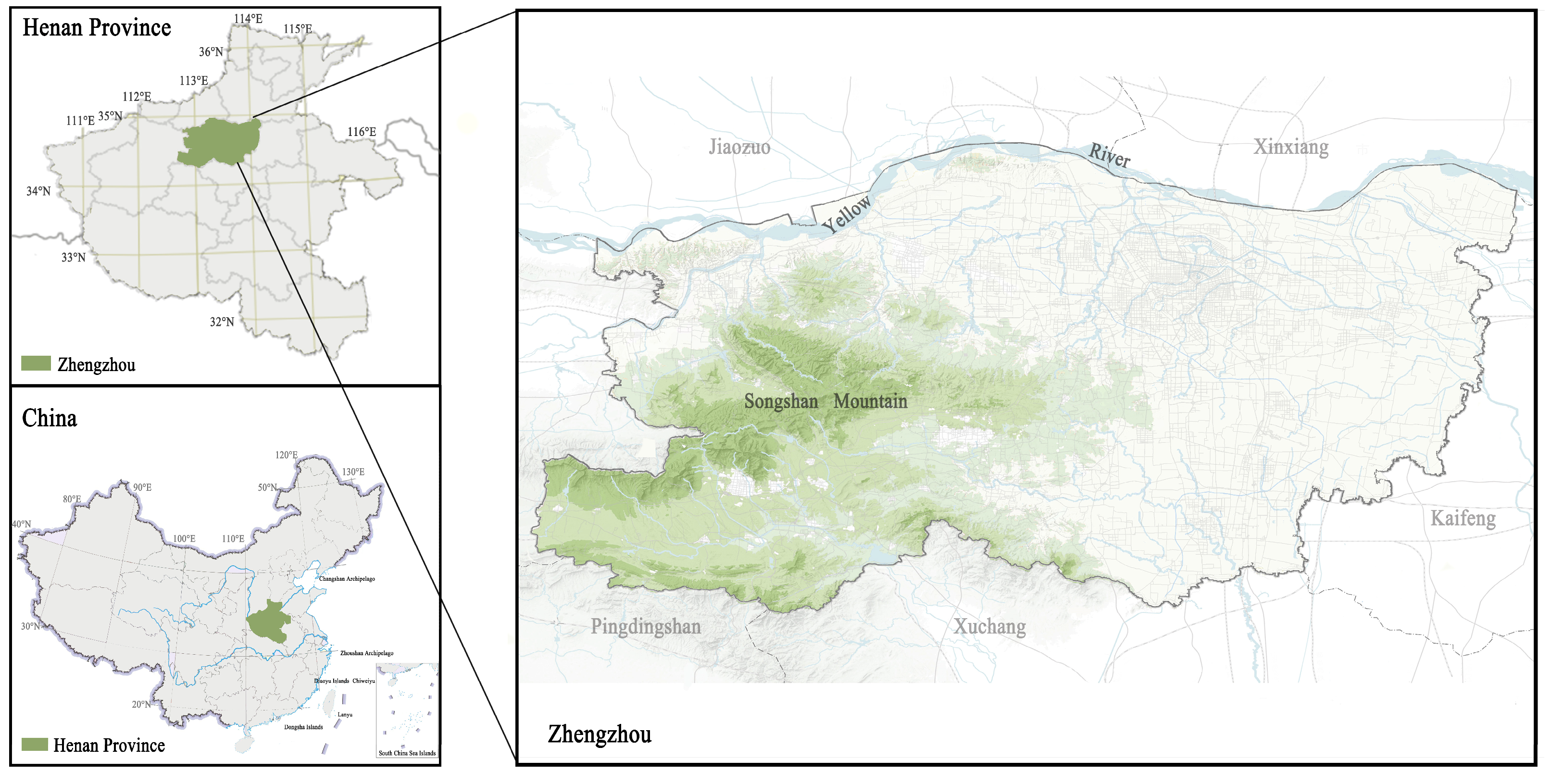
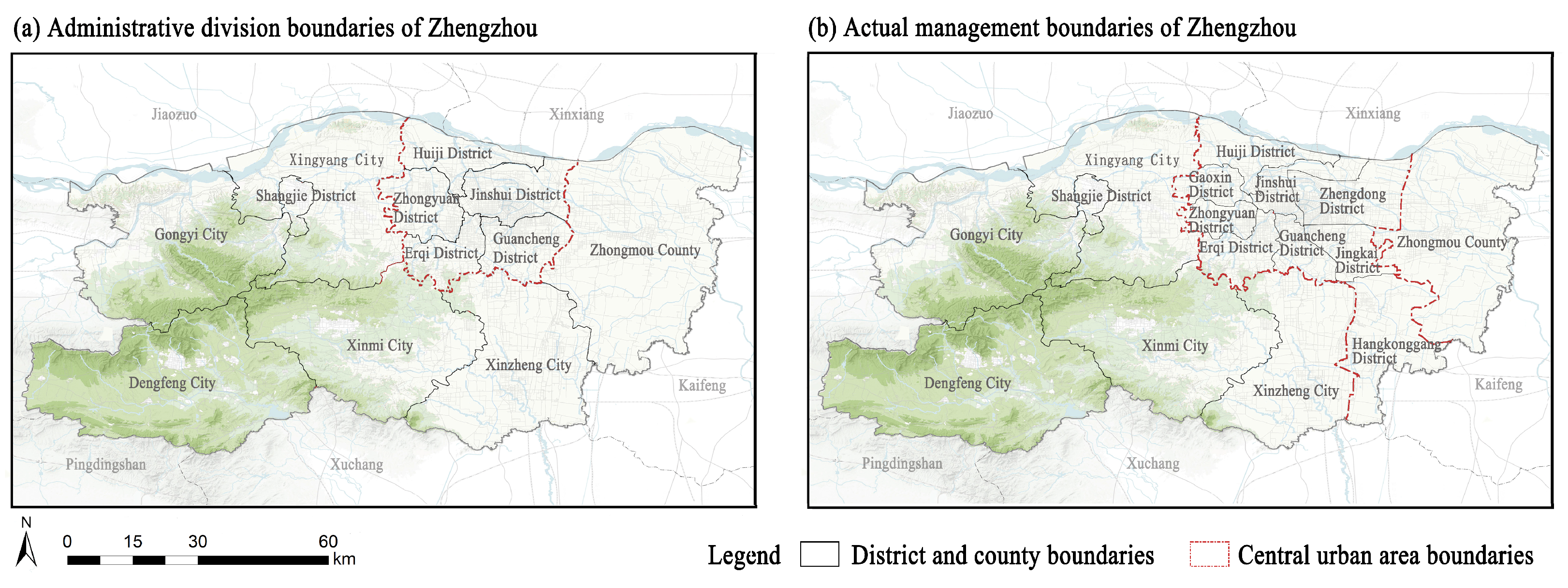
2.1. Study Area
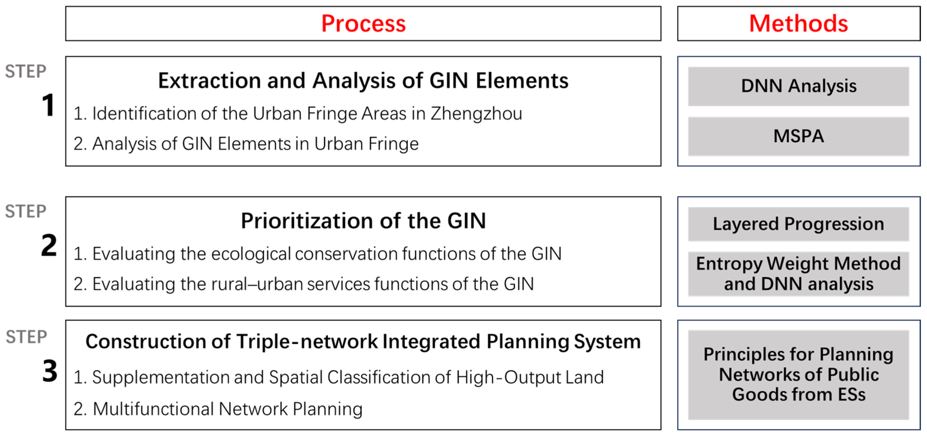
2.2. Research Design
2.3. Data Sources and Processing
2.4. Identification of Urban Fringe Areas and GIN Element Analysis
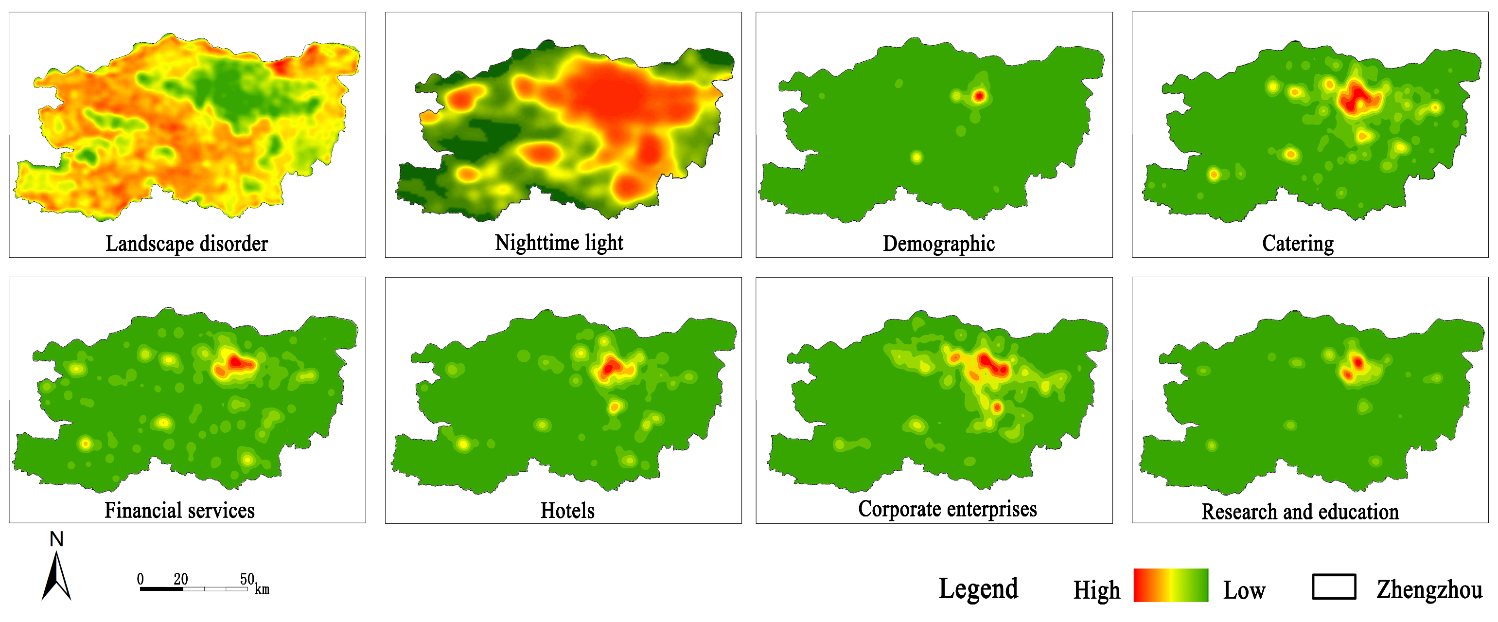
2.4.1. Identification of Urban Fringe Areas Based on a Deep Neural Network Model
2.4.2. Analysis of GIN Elements in an Urban Fringe
2.5. Prioritization of the Green Infrastructure Network
2.5.1. Evaluating the Ecological Conservation Functions of the GIN
2.5.2. Evaluating the Rural-Urban Service Functions of the GIN
2.6. Construction of a Triple-Network Integrated Planning System
3. Results
3.1. Construction of Integrated Green Infrastructure Networks
3.1.1. Identification of Urban Fringe Areas
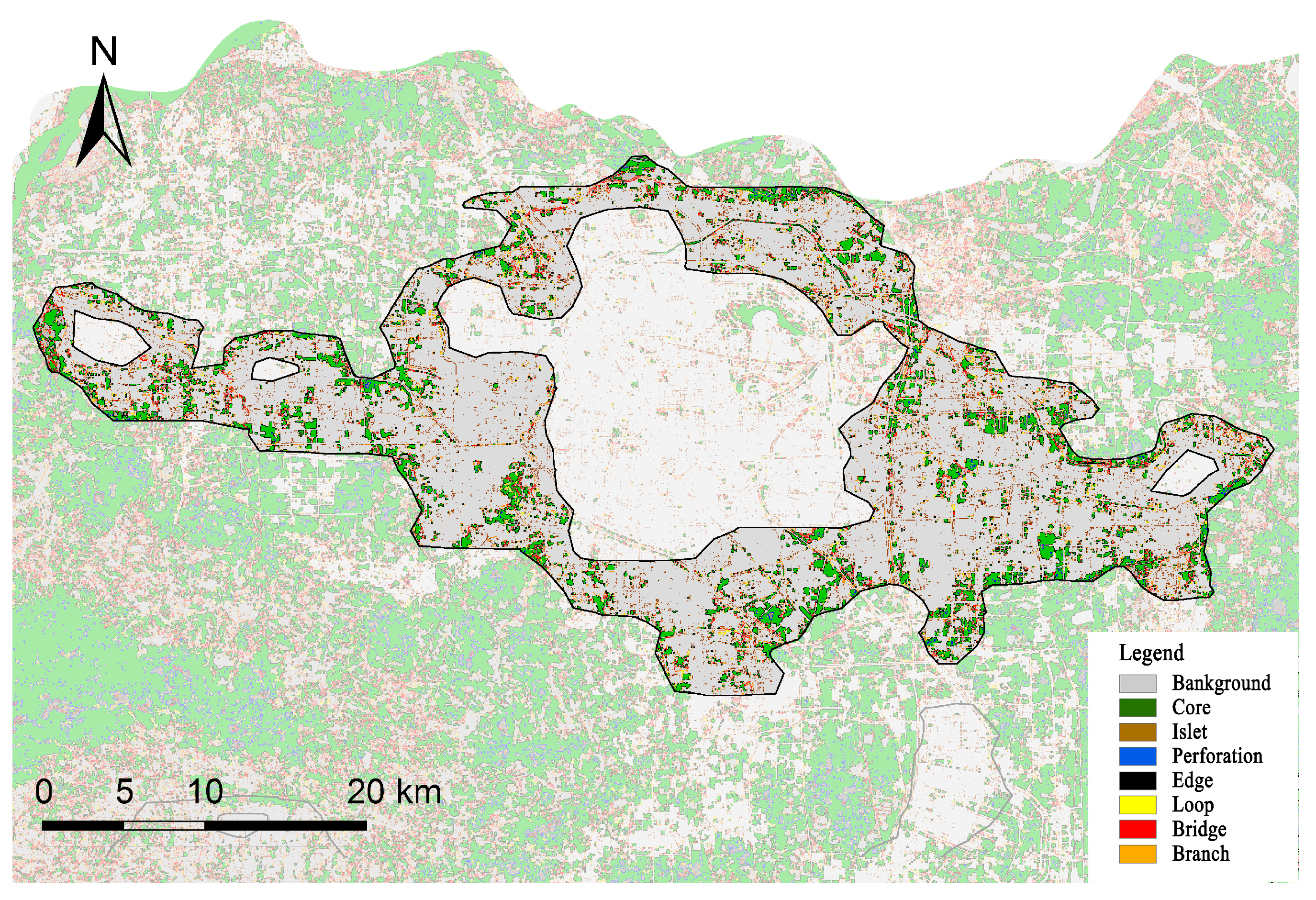
3.1.2. Analysis of GIN Elements in the Urban Fringe
3.2. Prioritization of the Green Infrastructure Network
3.3. Construction of a Triple-Network Integrated Planning System
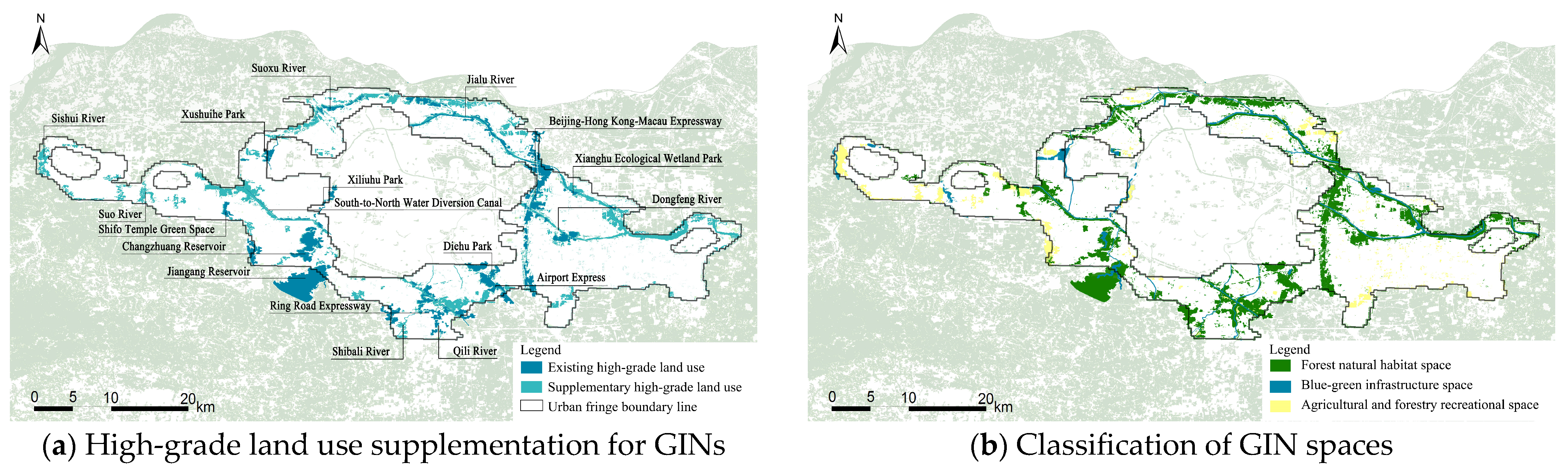
3.3.1. Supplementation and Spatial Classification of High-Output Land for GIN
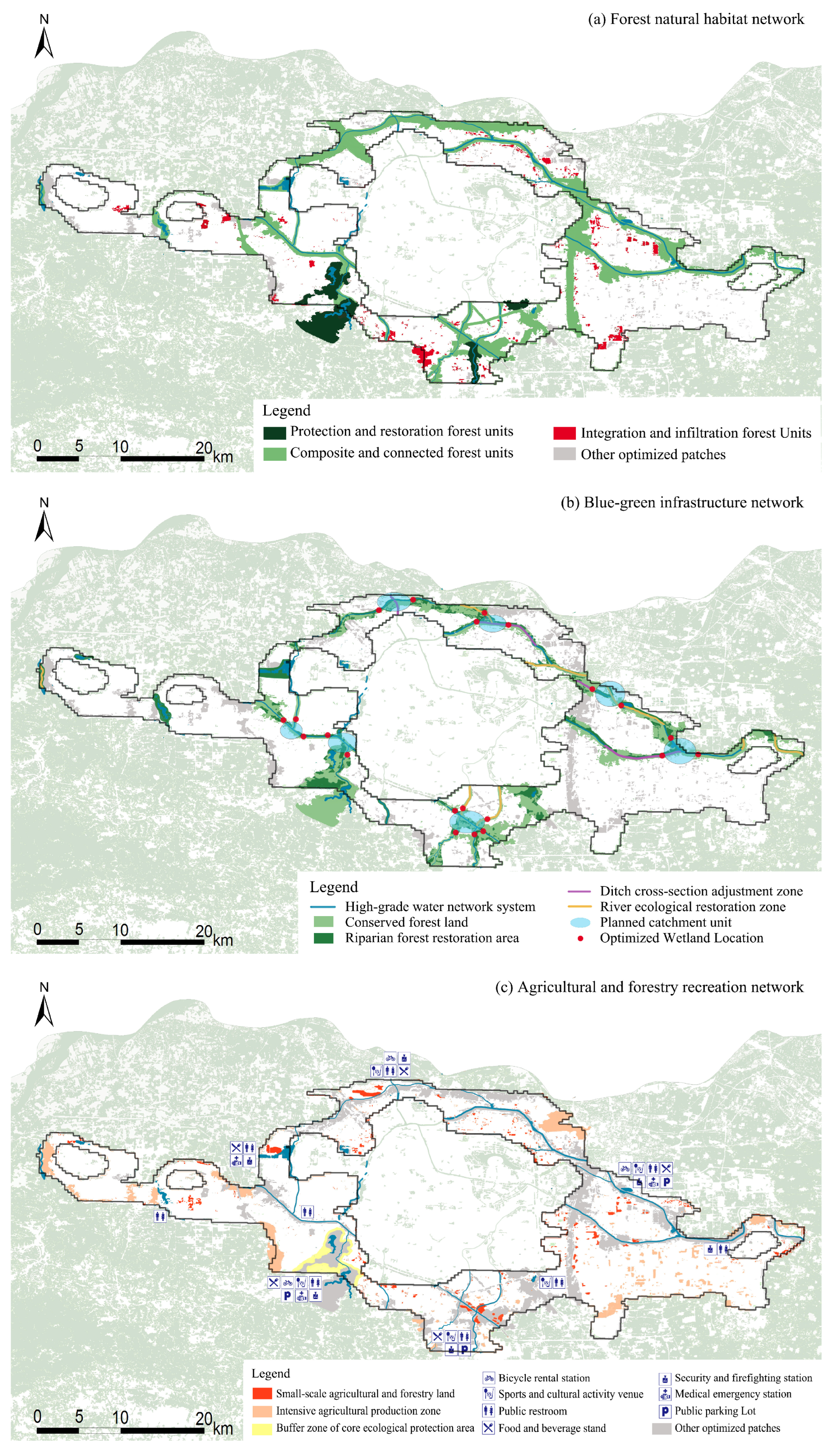
3.3.2. Multifunctional Network Planning
4. Discussion
4.1. Forest Natural Space Design for GIN Planning
4.2. Blue-Green Space Design for GIN Planning
4.3. Agroforestry Recreation Space Design for GIN Planning
4.4. Triple-Network Overlay and Service Performance-Oriented Scheme Adjustment
4.5. Limitations and Future Directions
5. Conclusions
Author Contributions
Funding
Data Availability Statement
Acknowledgments
Conflicts of Interest
References
- John, B.; Luederitz, C.; Lang, D.J.; von Wehrden, H. Toward Sustainable Urban Metabolisms. From System Understanding to System Transformation. Ecol. Econ. 2019, 157, 402–414. [Google Scholar] [CrossRef]
- Lynn, J.; Peeva, N. Communications in the IPCC’s Sixth Assessment Report cycle. Clim. Chang. 2021, 169, 18. [Google Scholar] [CrossRef] [PubMed]
- Kalnay, E.; Cai, M. Impact of Urbanization and Land-Use Change on Climate. Nature 2003, 423, 528–531. [Google Scholar] [CrossRef] [PubMed]
- Wang, Y.C.; Shen, J.K.; Xiang, W.N. Ecosystem Service of Green Infrastructure for Adaptation to Urban Growth: Function and Configuration. Ecosyst. Health Sustain. 2018, 4, 132–143. [Google Scholar] [CrossRef]
- Griffiths, M.B. Lamb Buddha’s Migrant Workers: Self-Assertion on China’s Urban Fringe. J. Curr. Chin. Aff. 2010, 39, 3–37. [Google Scholar] [CrossRef]
- Wang, Z.F.; Li, D.; Cheng, H.J.; Luo, T. Multifaceted Influences of Urbanization on Sense of Place in the Rural–Urban Fringes of China: Growing, Dissolving, and Transitioning. J. Urban Plann. 2020, 146, 04019026. [Google Scholar] [CrossRef]
- Saurav, C.; Indranil, M.; Pravin, P.P.; Hashem, D.; Suvamoy, P.; Alexander, F.; Josef, N.; Utpal, R. Spatio-temporal Patterns of Urbanization in the Kolkata Urban Agglomeration: A Dynamic Spatial Territory-Based Approach. Sustain. Cities Soc. 2021, 67, 102715. [Google Scholar] [CrossRef]
- Yang, J.Y.; Xing, Z.; Cheng, C.H. How Urban Fringe Expansion Affects Green Habitat Diversity? Analysis from Urban and Local Scale in Hilly City. J. Environ. Public Health 2022, 2022, 8566686. [Google Scholar] [CrossRef]
- Marques, A.L.; Alvim, A.T.B. Metropolitan Fringes as Strategic Areas for Urban Resilience and Sustainable Transitions: Insights from Barcelona Metropolitan Area. Cities 2024, 150, 105018. [Google Scholar] [CrossRef]
- Xiao, D.Q.; Yuan, Q.; Xu, X.C.; Zhang, S.B. Investigating Injury Severity Interaction Between Urban and Urban-Rural Fringe Areas: A Grouped Random Parameters Seemingly Unrelated Bivariate Probit Approach. Int. J. Inj. Control Saf. Promot. 2024, 31, 30–37. [Google Scholar] [CrossRef]
- Korkou, M.; Tarigan, A.K.M.; Hanslin, H.M. The Multifunctionality Concept in Urban Green Infrastructure Planning: A Systematic Literature Review. Urban For. Urban Green. 2023, 85, 127975. [Google Scholar] [CrossRef]
- Wang, D.M.; Guo, Y.; Liu, C.; Tang, P.X.; Jiao, J.; Kong, W.H.; Liu, Y.P.; Kong, D.Z. Identification of High-Value Land for Green Infrastructure in Urban Fringe Areas: A Case Study of Zhengzhou, Henan Province, China. J. Urban Plann. Dev. 2023, 149, 05023005. [Google Scholar] [CrossRef]
- Jeong, D.; Kim, M.; Song, K.; Lee, J. Planning a Green Infrastructure Network to Integrate Potential Evacuation Routes and the Urban Green Space in a Coastal City: The Case Study of Haeundae District, Busan, South Korea. Sci. Total Environ. 2020, 761, 143179. [Google Scholar] [CrossRef] [PubMed]
- Wang, D.S.; Zheng, H.; Ouyang, Z.Y. Ecosystem services supply and consumption and their relationships with human well-being. Chin. J. Appl. Ecol. 2013, 6, 1747–1753. [Google Scholar]
- Artmann, M.; Bastian, O.; Grunewald, K. Using the Concepts of Green Infrastructure and Ecosystem Services to Specify Leitbilder for Compact and Green Cities: The Example of the Landscape Plan of Dresden (Germany). Sustainability 2017, 9, 198. [Google Scholar] [CrossRef]
- Allan, P.; Bryant, M. Resilience as a Framework for Urbanism and Recovery. J. Landsc. Archit. 2011, 6, 34–45. [Google Scholar] [CrossRef]
- Monteiro, R.; Ferreira, J.C.; Antunes, P. Green Infrastructure Planning Principles: An Integrated Literature Review. Land 2020, 9, 525. [Google Scholar] [CrossRef]
- Gober, P.; Burns, E.K. The Size and Shape of Phoenix’s Urban Fringe. J. Plann. Educ. Res. 2002, 21, 379–390. [Google Scholar] [CrossRef]
- Duan, H.R.; Du, F.G.; Zhang, Y.J.; Jiang, X.J.; Chen, B. An Urban-Rural Fringe Extraction Method Based on Combined Urban-Rural Fringe Index (CUFI). Geocarto Int. 2024, 39, 2311211. [Google Scholar] [CrossRef]
- Pénzes, J.; Hegedus, L.D.; Makhanov, K.; Túri, Z. Changes in the Patterns of Population Distribution and Built-Up Areas of the Rural-Urban Fringe in Post-Socialist Context: A Central European Case Study. Land 2023, 12, 1682. [Google Scholar] [CrossRef]
- Alpesh, M.P. Adaboosted Extra Trees Classifier for Object-Based Multispectral Image Classification of Urban Fringe Area. Int. J. Image Graph. 2022, 22, 2140006. [Google Scholar] [CrossRef]
- Wang, Y.; Han, Y.L.; Pu, L.J.; Jiang, B.; Yuan, S.F.; Xu, Y. A Novel Model for Detecting Urban Fringe and Its Expanding Patterns: An Application in Harbin City, China. Land 2021, 10, 876. [Google Scholar] [CrossRef]
- Wang, C.R.; Sun, X.; Liu, Z.F.; Xia, L.; Liu, H.X.; Fang, G.J.; Liu, Q.H.; Yang, P. A Novel Full-Resolution Convolutional Neural Network for Urban-Fringe-Rural Identification: A Case Study of Urban Agglomeration Region. Landsc. Urban Plann. 2024, 249, 105122. [Google Scholar] [CrossRef]
- Li, J.F.; Peng, B.; Liu, S.Q.; Ye, H.P.; Zhang, Z.Y.; Nie, X.W. An Accurate Fringe Extraction Model of Small- and Medium-Sized Urban Areas Using Multi-Source Data. Front. Environ. Sci. 2023, 11, 1118953. [Google Scholar] [CrossRef]
- Zhu, J.; Lang, Z.Q.; Wang, S.; Zhu, M.Y.; Na, J.M.; Zheng, J.Z. Using Dual Spatial Clustering Models for Urban Fringe Areas Extraction Based on Night-Time Light Data: Comparison of NPP/VIIRS, Luojia 1-01, and NASA’s Black Marble. ISPRS Int. J. Geo-Inf. 2023, 12, 408. [Google Scholar] [CrossRef]
- Hinton, G.E.; Salakhutdinov, R.R. Reducing the dimensionality of data with neural networks. Science 2006, 313, 504–507. [Google Scholar] [CrossRef]
- Zhou, D.X. Universality of deep convolutional neural networks. Appl. Comput. Harmon. Anal. 2020, 48, 787–794. [Google Scholar] [CrossRef]
- Li, G.Y.; Cao, Y.; He, Z.C.; He, J.; Wang, J.Y.; Fang, X.Q. Understanding the diversity of urban-rural fringe development in a fast urbanizing region of China. Remote Sens. 2021, 13, 2373. [Google Scholar] [CrossRef]
- Shen, J.K.; Guo, X.L.; Wang, Y.C. Identifying and setting the natural spaces priority based on the multi-ecosystem services capacity index. Ecol. Indic. 2021, 125, 107473. [Google Scholar] [CrossRef]
- Badiu, D.L.; Nita, A.; Ioja, C.I.; Nita, M.R. Disentangling the connections: A network analysis of approaches to urban green infrastructure. Urban For. Urban Green. 2019, 41, 211–220. [Google Scholar] [CrossRef]
- Serra, V.; Defraia, S.; Ledda, A.; Calia, G.; Corona, F.; De Montis, A.; Mulas, M. Ecological network, ecosystem services, and green infrastructure planning: A method for the metropolitan city of Cagliari, Italy. Netw. Spat. Econ. 2024, 4, 1–26. [Google Scholar] [CrossRef]
- The People’s Government of Henan Province. Spatial Planning of Zhengzhou Metropolitan Area (2018–2035). 2017. Available online: https://www.henan.gov.cn/ (accessed on 12 March 2021).
- The People’s Government of Zhengzhou. Zhengzheng Tong〔2022〕No. 13. Available online: https://public.zhengzhou.gov.cn/?a=theme&n=5 (accessed on 18 February 2023).
- Choi, J.Y.; Yu, E.S.H. A public-good approach to environmental economy. Int. J. Econ. Theory 2019, 15, 269–280. [Google Scholar] [CrossRef]
- Xing, Z.; Tang, X.Z.; Zhou, Q.; Gu, Y.Y.; Chen, Z.L. Green infrastructure network planning in urban fringe: From the perspective of ensuring public goods output. City Plann. Rev. 2020, 44, 57–69. [Google Scholar] [CrossRef]
- Matin, S.; Sullivan, C.A.; Finn, J.A.; hUallacháin, D.O.; Green, S.; Meredith, D.; Moran, J. Assessing the distribution and extent of High Nature Value farmland in the Republic of Ireland. Ecol. Indic. 2019, 108, 105700. [Google Scholar] [CrossRef]
- Wu, Y.Z.; Shi, K.F.; Chen, Z.Q.; Liu, S.R.; Chang, Z.J. Developing improved time-series DMSP-OLS-like data (1992–2019) in China by integrating DMSP-OLS and SNPP-VIIRS. IEEE Trans. Geosci. Remote Sens. 2022, 60, 4407714. [Google Scholar] [CrossRef]
- GB 3838-2002; Environmental Quality Standards for Surface Water. State Environmental Protection Administration, General Administration of Quality Supervision, Inspection and Quarantine of the People’s Republic of China: Beijing, China, 2002. Available online: https://www.mee.gov.cn/ (accessed on 25 March 2020).
- GB 18918-2002; Discharge Standard of Pollutants for Municipal Wastewater Treatment Plant. State Environmental Protection Administration, General Administration of Quality Supervision, Inspection and Quarantine of the People’s Republic of China: Beijing, China, 2002. Available online: https://www.mee.gov.cn/ (accessed on 25 March 2020).
- Tao, F.; Liu, X.; Du, H.D.; Yu, W.B. Learning composite constitutive laws via coupling Abaqus and deep neural network. Compos. Struct. 2021, 272, 114137. [Google Scholar] [CrossRef]
- Raciti, S.M.; Hutyra, L.R.; Finzi, A.C. Depleted soil carbon and nitrogen pools beneath impervious surfaces. Environ. Pollut. 2012, 164, 248–251. [Google Scholar] [CrossRef]
- Fischer, J.; Hartel, T.; Kuemmerle, T. Conservation policy in traditional farming landscapes. Conserv. Lett. 2012, 5, 167–175. [Google Scholar] [CrossRef]
- Plieninger, T.; Torralba, M.; Hartel, T.; Fagerholm, N. Perceived ecosystem services synergies, trade-offs, and bundles in European high nature value farming landscapes. Landsc. Ecol. 2019, 34, 1565–1581. [Google Scholar] [CrossRef]
- Kontokosta, C.E. Urban informatics in the science and practice of planning. J. Plann. Educ. Res. 2018, 41, 382–395. [Google Scholar] [CrossRef]


| Name of Plans and Regulations | Issuing Authorities | Implementation Time |
|---|---|---|
| Zhengzhou Urban Green Space System Plan | Zhengzhou Municipal Administration Bureau, Zhengzhou Urban Planning Bureau | September 2002 |
| Zhengzhou Environmental Protection 12th Five-Year Plan | Zhengzhou Environmental Protection Bureau | April 2012 |
| Zhengzhou Action Plan for Advancing New Urbanization Construction (2016–2018) | Zhengzhou Municipal Government Office | August 2016 |
| Zhengzhou Comprehensive Land Use Plan (2006–2020) | Zhengzhou Municipal People’s Government | August 2017 |
| Zhengzhou Ecological Environmental Protection 13th Five-Year Plan | Zhengzhou Environmental Protection Bureau | November 2017 |
| Guidelines for Sponge City Planning and Design in Zhengzhou Construction Projects | Zhengzhou Bureau of Natural Resources and Planning | January 2018 |
| Zhengzhou Three-Year Action Plan for Winning the Battle for Clean Water (2018–2020) | Zhengzhou Bureau of Natural Resources and Planning | October 2018 |
| Zhengzhou Metropolitan Area Spatial Plan (2018–2035) | Henan Provincial Party Committee Office, Henan Provincial Government Office | December 2018 |
| Zhengzhou Implementation Plan for the Battle Against Air Pollution in 2019 | Zhengzhou Municipal People’s Government | April 2019 |
| (Zhengzhou National Central City Forest Ecosystem Plan (2019–2025) | Zhengzhou Municipal People’s Government | August 2019 |
| Implementation Opinions on Further Strengthening Cultivated Land Protection | Zhengzhou Municipal People’s Government | November 2019 |
| Forest Zhengzhou Ecological Construction Plan (2020–2035) | Zhengzhou Municipal People’s Government | September 2020 |
| Date | Data Source | Data Scal/Type/Resolution | Data Processing |
|---|---|---|---|
| Landsat remote sensing image map | GDC (http://www.gscloud.cn) accessed on 22 May 2020 | Zhengzhou area/GRID/30 m | Synthesize, fuse, and create true-color mosaics of remote sensing images to form land satellite remote sensing imagery. |
| Land use/cover | GDC (http://www.gscloud.cn) accessed on 22 May 2020 | Zhengzhou area/GRID/30 m | Produced based on supervised classification of Landsat remote sensing images. |
| Landscape disorder | Generated based on the processing of land use/cover | Zhengzhou area/Vector shapefile (polygon)/100 m | where W is value of landscape disorder; Xn is ratio of a certain type of land use within a unit area to the area of a unit grid; n is number of land-use type patches within a unit grid. |
| Nighttime light date | Payne Institute for Public Policy (https://payneinstitute.mines.edu/eog/nighttime-lights/) accessed on 9 September 2020 | Zhengzhou area/Vector shapefile (polygon)/100 m | The corrected DMSP-OLS-like data for Zhengzhou in 2020, obtained by integrating DMSP-OLS and SNPP-VIIRS data [37]. Interpolation refinement. |
| Demographic date | Resource and Environmental Science Data Platform (https://www.resdc.cn/Default.aspx) accessed on 15 March 2021 | Zhengzhou area/Vector shapefile (polygon)/100 m | Interpolation refinement. |
| POI point data | Baidu Maps (https://map.baidu.com/) accessed on 20 May 2020 | Zhengzhou area/Vector shapefile (polygon)/100 m | Obtained from Baidu Maps using web scraping technology based on Python 3.7. |
| Water environment data | Report on the Ranking of River Water Quality in Zhengzhou City for 2020 (http://sthjj.zhengzhou.gov.cn/) and Gaode Environmental Map (https://ditu.amap.com/) accessed on 28 March 2021 | Urban fringe area of Zhengzhou/River section/1 m | The index calculation adopts the Class 3 standards from the Environmental Quality Standards for Surface Water (GB3838-2002) [38] and the Grade A1 standards from the Discharge Standard of Pollutants for Municipal Wastewater Treatment Plant (GB18918-2002) [39]. |
| Ecological protection land | Official Website of the Department of Natural Resources of Henan Province (https://dnr.henan.gov.cn/) accessed on 25 March 2021 | Zhengzhou area/Vector shapefile (polygon)/30 m | Based on the Guidelines for Defining Ecological Protection Redlines, the land area of the ecological protection zones was selected and converted into vector format. |
| Historical and cultural land | Official Website of the Department of Housing and Urban-Rural Development of Henan Province (https://hnjs.henan.gov.cn/), Official Website of the Henan Provincial Administration of Cultural Heritage (https://wwj.henan.gov.cn/) accessed on 25 March 2021 | Zhengzhou area/Vector shapefile (polygon)/30 m | Convert the land area into vector format. |
| Other land use data | Baidu Maps (https://ditu.amap.com/) | Zhengzhou area/Vector shapefile (polygon)/30 m | Convert the land area into vector format. |
| Functional Unit | Evaluation Factors | Evaluation Threshold | Unit | Basis | Patch Level |
|---|---|---|---|---|---|
| Disaster protection | Patch area | 0.1 | km2 | Results of the MSPA | Level 1 |
| Connectivity | dPC ≥ 1 | — | Importance of habitat patches | Level 2 | |
| Protection of critical or sensitive land | Water quality | III, II | — | Environmental Quality Standards for Surface Water GB 3838-2002 | Level 3 or Level 4 |
| Ecological conservation source areas | Yes | — | Guidelines for Delineating Ecological Protection Red Lines | Level 5 |
| Functional Unit | Evaluation Factors | Evaluation Threshold | Unit | Basis | Weight Value |
|---|---|---|---|---|---|
| Leisure and recreation | Proximity to urban functional areas | 800, 1000, 1500, 2000, 3000 | m | Classification of Urban Land Use and Planning Construction Land Standards GB 50137-2011 | 0.1891 |
| Proximity to existing scenic areas | 2000, 2500, 3000, 3500, 5000 | m | General Planning Standards for Scenic Areas GB/T 50298-2018 | 0.0703 | |
| Greenway/waterfront connectivity | 300, 500, 800, 1000, 1500 | m | Classification of Urban Land Use and Planning Construction Land Standards GB 50137-2011 | 0.1225 | |
| Transport accessibility | 5, 10, 15, 20, 25 | min | Planning and Design Standards for Urban Residential Areas GB 50180-2018 | 0.1949 | |
| Historical preservation | Historical Heritage Protection Levels | County-level Cultural Heritage Protection Units (I); Municipal-level Cultural Heritage Protection Units (II); Provincial-level Cultural Heritage Protection Units, and Historical and Cultural Districts, Villages, and Towns (III); Historical and Cultural Cities, and Towns, Villages of China (IV); National Key Cultural Heritage Protection Units (V) | — | Law of the People’s Republic of China on the Protection of Cultural Relics (2017 Revised Edition) | 0.1093 |
| Land protection | Proximity to high-density development area | 800, 1000, 1500, 2000, 3000 | m | Classification of Urban Land Use and Planning Construction Land Standards GB 50137-2011 | 0.1816 |
| Proximity to municipal facilities | 300, 500, 800, 1000, 1500 | m | Classification of Urban Land Use and Planning Construction Land Standards GB 50137-2011 | 0.1323 |
| Types of GIN | Included Landscape Types | ESs Production | Ecosystem Function Support Requirements |
|---|---|---|---|
| Forest natural habitat space | Natural/semi-natural habitat functional unit, land conservation functional unit, natural forest corridor, artificial ecological corridor | Establishing continuous habitat networks to maintain regional biodiversity | ① Protecting core natural habitats and connectivity zones ② Strengthening the connection between small patches and core areas ③ Reducing external negative impacts |
| Blue-green infrastructure space | Rivers, lakes, and riparian green spaces | Restoring river systems and their corridor functions to enhance ecosystem, recreational, and other service outputs | ① Mapping river systems and wetland ponds ② Enhancing public service outputs capacity through wetland and river corridor development ③ Integrating urban GINs |
| Agroforestry recreational space | Small-scale farmlands, orchards, grasslands, and semi-natural forests | Restoring agricultural landscapes to ensure the supply of resources and recreational services | ① Protecting small-scale, high-yield land patches ② Strengthening the construction of forest networks in agricultural production areas ③ Enhancing the connection and interaction with hydrological processes |
| Landscape Types | Core | Perforation | Loop | Islet | Edge | Bridge | Branch | Total |
|---|---|---|---|---|---|---|---|---|
| Farmland | 31.66 | 1.17 | 2.79 | 4.83 | 21.04 | 6.95 | 8.54 | 76.98 |
| Woodland | 61.7 | 1.09 | 4.93 | 23.63 | 47.29 | 12.76 | 20.61 | 172.01 |
| Grassland | 18.67 | 0.41 | 1.17 | 4.88 | 13.51 | 4.04 | 5.75 | 48.43 |
| Water body | 7.00 | 0.05 | 0.37 | 0.53 | 2.21 | 1.13 | 0.68 | 11.97 |
| Total | 120.53 | 2.82 | 9.36 | 34.27 | 85.05 | 25.18 | 36.08 | 313.29 |
| Proportion of GI in the urban fringe area (%) | 38.47 | 0.88 | 2.99 | 10.95 | 27.17 | 8.04 | 11.50 | 100.00 |
| Proportion of the urban fringe area (%) | 11.75 | 0.27 | 0.91 | 3.34 | 8.30 | 2.46 | 3.51 | 30.54 |
| Project | Blue-Green Infrastructure Space | Forest Habitat Conservation | Protection of Productive Green Spaces | Water Resource Conservation | ||||
|---|---|---|---|---|---|---|---|---|
| Forest Cover Rate | Network Connectivity | Reserved Forest Land | Restored Forest Land | Reconstructed Forest Land | Reserved Ponds | River and Ditch Rehabilitation | ||
| Existing | 6.70% | 1.02 | 71.33 km2 | 2.16% | / | / | ||
| Planning | 11.03% | 1.45 | 60.52% | 43.21% | 19.51% | 2.64% | 89 | 116.31 km |
| Change | (+) 4.33% | 42.16% | (+) 62.72% | (+) 0.48% | / | / | ||
Disclaimer/Publisher’s Note: The statements, opinions and data contained in all publications are solely those of the individual author(s) and contributor(s) and not of MDPI and/or the editor(s). MDPI and/or the editor(s) disclaim responsibility for any injury to people or property resulting from any ideas, methods, instructions or products referred to in the content. |
© 2025 by the authors. Licensee MDPI, Basel, Switzerland. This article is an open access article distributed under the terms and conditions of the Creative Commons Attribution (CC BY) license (https://creativecommons.org/licenses/by/4.0/).
Share and Cite
Wang, D.; Zhao, C.; Xia, B.; Zhang, C.; Kong, D.; Fan, Q. Green Infrastructure Network Planning in Urban Fringe Areas Based on the Characteristics of Agricultural and Forestry Landscape Ecological Network in a Metropolitan City. Land 2025, 14, 572. https://doi.org/10.3390/land14030572
Wang D, Zhao C, Xia B, Zhang C, Kong D, Fan Q. Green Infrastructure Network Planning in Urban Fringe Areas Based on the Characteristics of Agricultural and Forestry Landscape Ecological Network in a Metropolitan City. Land. 2025; 14(3):572. https://doi.org/10.3390/land14030572
Chicago/Turabian StyleWang, Dongmeng, Can Zhao, Baolin Xia, Chenming Zhang, Dezheng Kong, and Qindong Fan. 2025. "Green Infrastructure Network Planning in Urban Fringe Areas Based on the Characteristics of Agricultural and Forestry Landscape Ecological Network in a Metropolitan City" Land 14, no. 3: 572. https://doi.org/10.3390/land14030572
APA StyleWang, D., Zhao, C., Xia, B., Zhang, C., Kong, D., & Fan, Q. (2025). Green Infrastructure Network Planning in Urban Fringe Areas Based on the Characteristics of Agricultural and Forestry Landscape Ecological Network in a Metropolitan City. Land, 14(3), 572. https://doi.org/10.3390/land14030572