
Vegetation, Architecture, and Human Activities: Reconstructing Land Use History from the Late Yangshao Period in Zhengzhou Region, Central China

Abstract
1. Introduction
1.1. Settlement Structure and Architectural Technologies of the Late Yangshao Zhengzhou Region
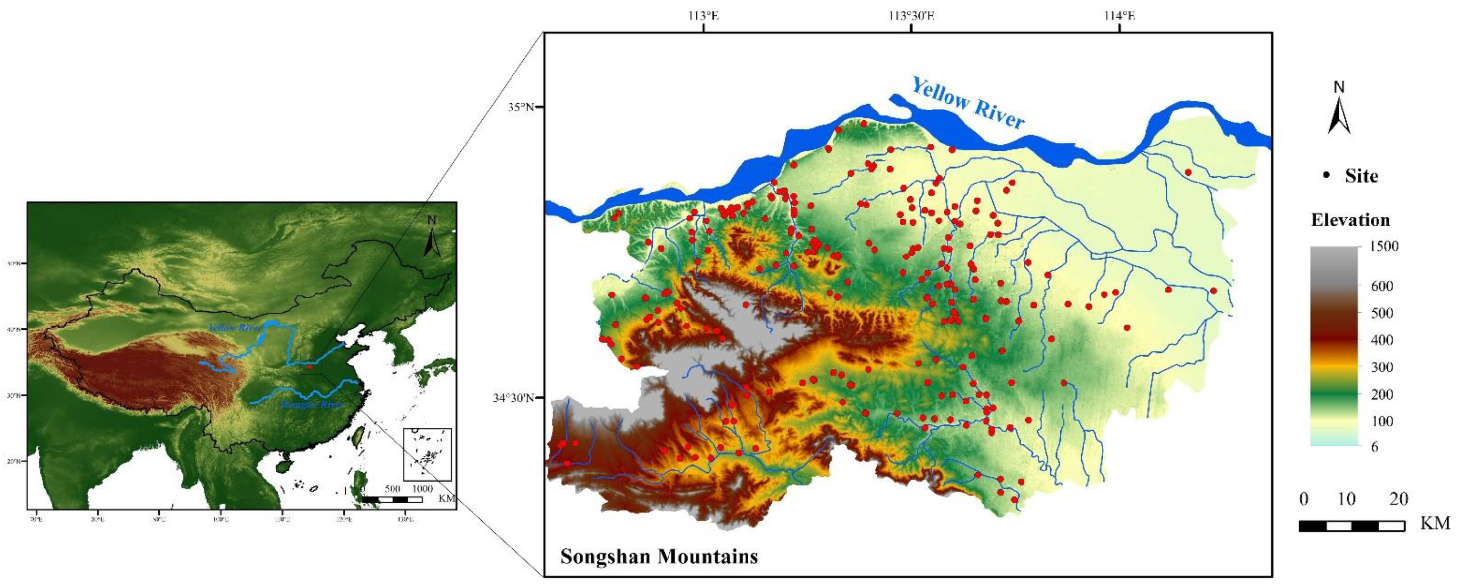
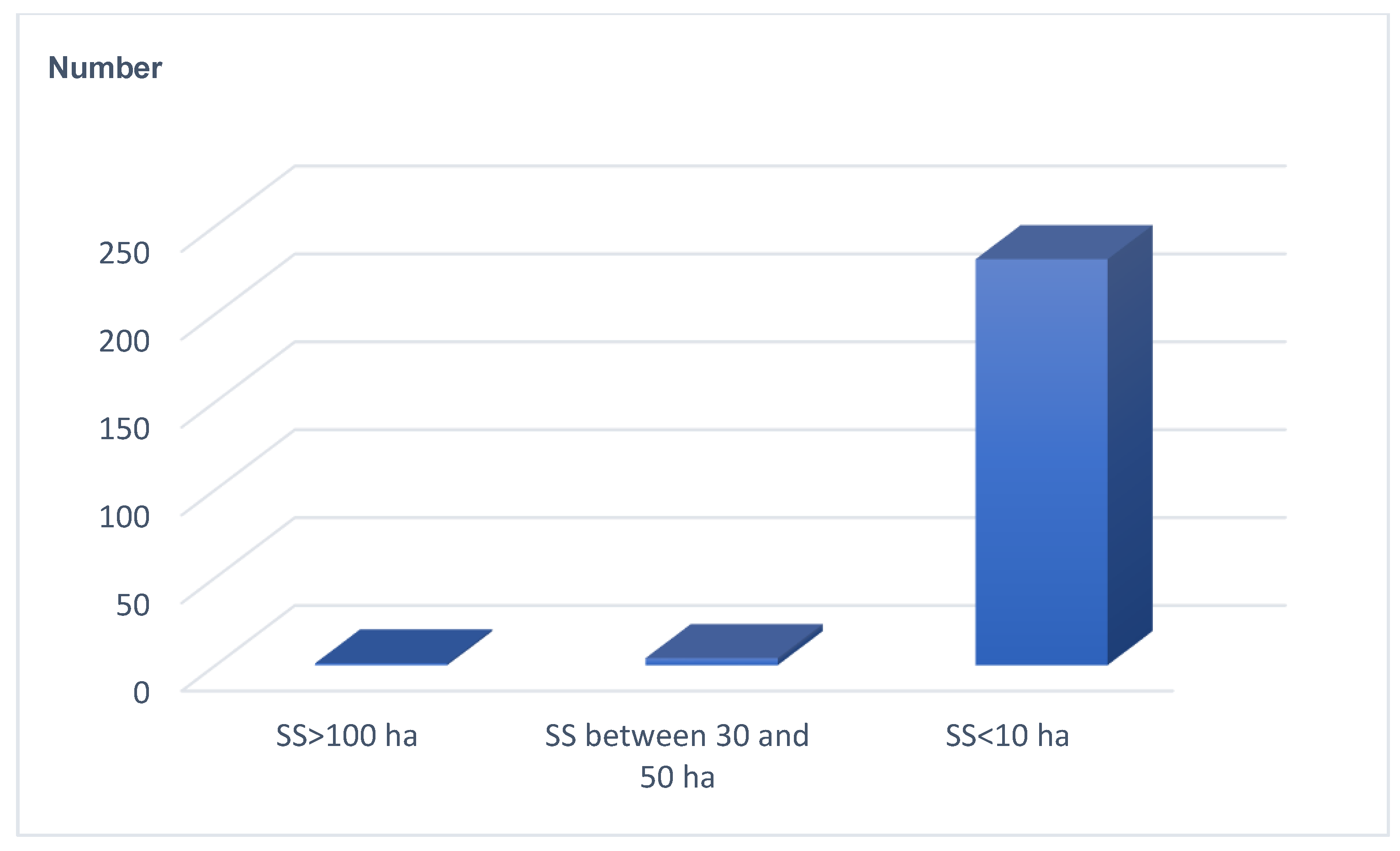
1.2. Structure and Tier of Settlements from Late Yangshao in Zhengzhou Region
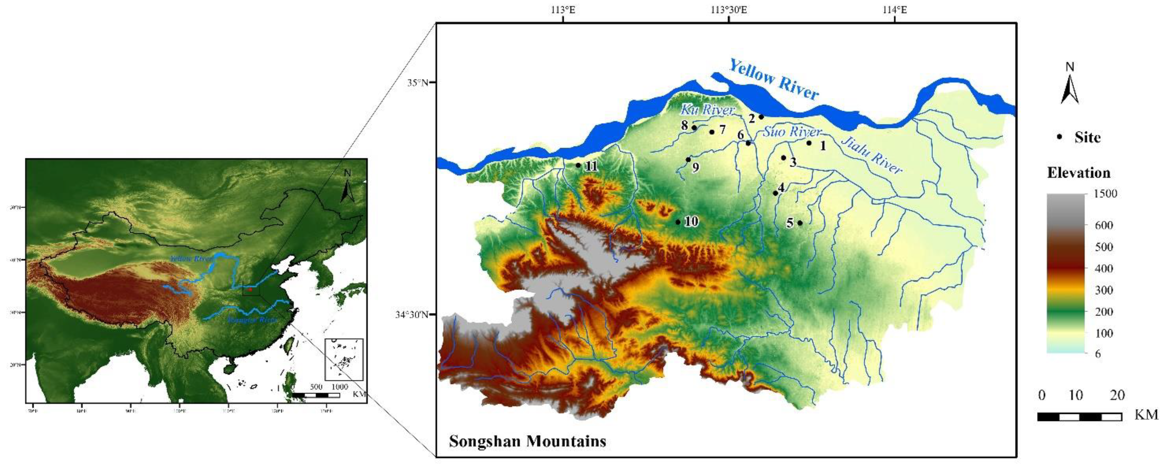
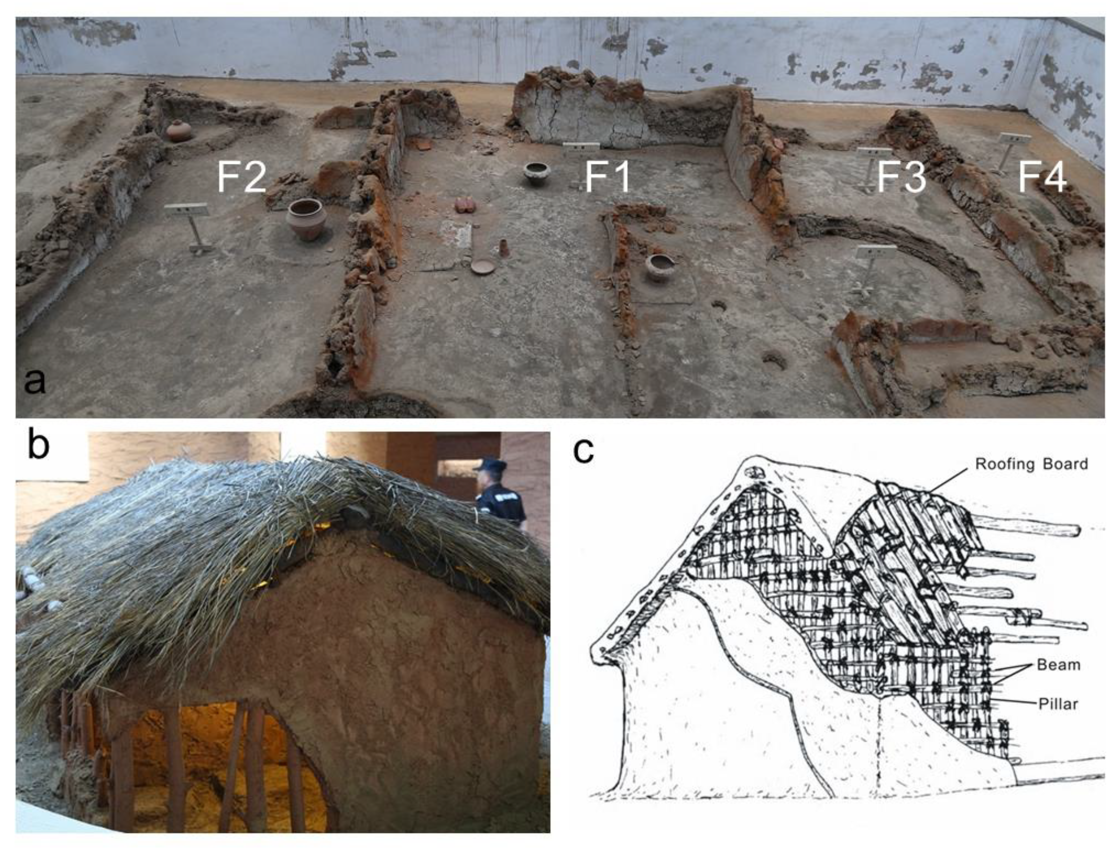
1.3. Introduction of Dahecun Site
1.4. Architectural Technologies: The Maturation of the Wood Skeleton and Mud Walls Technology and the Emergence of Large Row Houses and Individual Buildings
2. Materials and Methods
2.1. Sampling and Dating
2.2. Laboratory Methods
3. Results
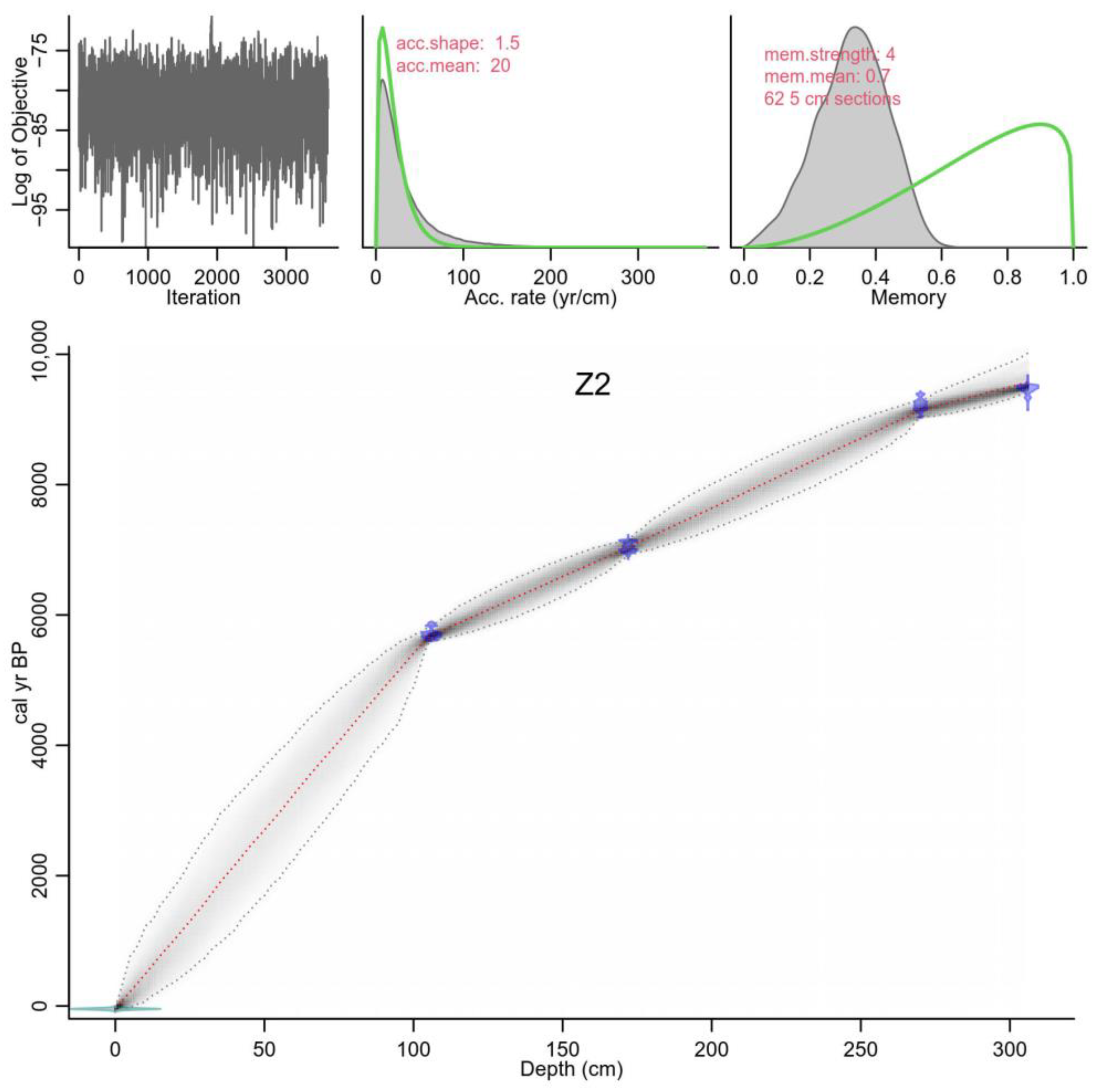
3.1. Age
3.2. Pollen Assemblages and Vegetation Composition
3.3. Wood Consumption in Late Yangshao Culture Period, Zhengzhou Region
4. Discussion
4.1. The History of Vegetation Succession and Climate Change Since 9.8 cal. ka BP in the Zhengzhou Region of the Central Plain
4.2. Deforestation, Vegetation, and Ecosystem: Is There an Early Anthropocene in Mid-Holocene Central Plains?
4.3. Pollen, Charcoal, and Other Proxy Approaches Indicated Deforestation in Late Yangshao Period
4.4. Deforestation and Its Impact on Ecosystem, Shift of House Pattern After Late Yangshao Period in China, Prospects
5. Conclusions
Author Contributions
Funding
Data Availability Statement
Conflicts of Interest
References
- Gu, W.F. Preliminary research on the important archaeological discoveries and relevant problems concerning Yangshao Culture in its middle and late period in Zhengzhou area. J. Huanghe S T Coll. 2023, 25, 4–19, (In Chinese with English Abstract). [Google Scholar]
- Jin, S.A.; Zhang, J. The origin of early cities in China from the perspective of the Yangshao Culture settlements in the Zhengzhou area. J. Zhengzhou Univ. 2015, 48, 135–140. (In Chinese) [Google Scholar]
- Cao, D.L.; Wang, C.; Gu, W.F.; Lu, H.Y. Preliminary study of the farming organization pattern in the central plains during the middle and the late Yangshao period: A case from Zhengzhou region. Agric. Hist. China 2022, 41, 31–43, (In Chinese with English Abstract). [Google Scholar]
- Wang, C.; Lu, H.Y.; Gu, W.F.; Wu, N.Q.; Zhang, J.P.; Zuo, X.X.; Li, F.J.; Wang, D.J.; Dong, Y.J.; Wang, S.Z.; et al. Spatial-temporal evolution of agriculture and factors influencing it during the mid-Holocene in Zhengzhou area, China. Quat. Sci. 2019, 39, 108–122, (In Chinese with English Abstract). [Google Scholar]
- Li, Y.F.; Yu, G.; Li, C.H.; Hu, S.Y.; Shen, H.D.; Yin, G. Environment reconstruction of mid-Holocene paleo-lakes in Zhengzhou and surrounding regions and the significance for human cultural development in central China. Mar. Geol. Quat. Geol. 2014, 34, 143–154, (In Chinese with English Abstract). [Google Scholar]
- Yang, F.; Gu, W.F.; Jin, G.Y. Analysis of carbonized botanic remains from Wanggou site in Zhengzhou. Agric. Hist. China 2020, 39, 3–12+35, (In Chinese with English Abstract). [Google Scholar]
- Doyen, E.; Bégeot, C.; Simonneau, A.; Simonneau, A.; Millet, L.; Chapron, E.; Arnaud, F.; Vannière, B. Land use development and environmental responses since the Neolithic around Lake Paladru in the French Pre-alps. J. Archaeol. Sci. Rep. 2016, 7, 48–59. [Google Scholar] [CrossRef]
- Tao, D.W.; Xu, J.J.; Wu, Q.; Gu, W.F.; Wei, Q.L.; Zhou, Y.W.; Richards, M.P.; Zhang, G.W. Human diets, crop patterns, and settlement hierarchies in third millennium BC China: Bioarchaeological perspectives in Zhengluo region. J. Arch. Sci. 2022, 145, 105647. [Google Scholar] [CrossRef]
- Yang, M.M.; Yang, Y.Z.; Gu, W.F.; Cui, Q.L.; Zhang, J.Z. Agricultural economy of late Yangshao and early Longshan period in central plain: Archaeobotanical evidence from the Shuanghuaishu site. Agric. Hist. China 2024, 43, 48–58, (In Chinese with English Abstract). [Google Scholar]
- Ren, X.L.; Xu, J.J.; Wang, H.; Storozum, M.; Lu, P.; Mo, D.W.; Li, T.Y.; Xiong, J.G.; Kidder, T.R. Holocene fluctuations in vegetation and human population demonstrate social resilience in the prehistory of the Central Plains of China. J. Environ. Res. Lett. 2021, 16, 055030. [Google Scholar] [CrossRef]
- Chen, W.Y.; Zhao, R.F.; Lu, H.T. Response of ecological environment quality to land use transition based on dryland oasis ecological index (DOEI) in dryland: A case study of oasis concentration area in Middle Heihe River, China. Ecol. Indic. 2024, 165, 112214. [Google Scholar] [CrossRef]
- Ran, Y.J.; Zhao, X.Q.; Ye, X.M.; Wang, X.B.; Pu, J.W.; Huang, P.; Zhou, Y.Q.; Tao, J.Y.; Wu, B.H.; Dong, W.W.; et al. A framework for territorial spatial ecological restoration zoning integrating “Carbon neutrality” and “Human-geology-ecology”: Theory and application. Sustain. Cities Soc. 2024, 115, 105824. [Google Scholar] [CrossRef]
- Zhang, M.; Chen, E.; Zhang, C.; Liu, C.; Li, J. Multi-scenario simulation of land use change and ecosystem service value based on the Markov–FLUS model in Ezhou City, China. Sustainability 2024, 16, 6237. [Google Scholar] [CrossRef]
- Chen, F.H.; Cheng, B.; Zhao, Y.; Zhu, Y.; Madsen, D.B. Holocene environmental change inferred from a high-resolution pollen record, Lake Zhuyeze, arid China. Holocene 2006, 16, 675–684. [Google Scholar] [CrossRef]
- Liu, C.H.; Ge, Y.W.; Li, Y.C.; Shen, G.H.; Yang, X.L.; She, Z.J.; Fan, B.S.; Jia, H.Y. Holocene pollen records from a large shallow lake in East Asia: Complexity of climate changes, environmental variations, and human activities. Catena 2025, 248, 108586. [Google Scholar] [CrossRef]
- Wang, H.Y.; Jin, Y.L.; Li, K.; Liao, M.N.; Liu, Y.; Ma, C.M.; Ye, W.; Zhang, Y.; Luo, Y.K.; Ni, J. Holocene Neolithic human activity shaped ecosystem functions through the altering of vegetation traits in Zhejiang, eastern China. Quat. Sci. Rev. 2024, 335, 108762. [Google Scholar] [CrossRef]
- Zhang, X.L.; Qiu, S.H.; Zhong, J.; Lu, X.F.; Zhao, X.P.; Fan, W.Q.; Li, X.W.; Ma, X.L.; Zhang, X.Y.; Guo, Y.Q. The discussion on the dating of Yangshao Culture. Archaelogy 2013, 11, 84–104, (In Chinese with English Abstract). [Google Scholar]
- IACASS; ICRAZZ; MXM. Archaeological Investigation Report on Settlements in the Zhenwei River; Cultural Relics Press: Beijing, China, 2023. [Google Scholar]
- IACASS; ICRAZZ. The Theory and Practice of Chinese Settlement Archaeology (Volume 1)—Collection of Papers from the Academic Symposium Marking the 30th Anniversary of the Excavation of Xinzhai Site; China Science Publishing: Beijing, China, 2010. [Google Scholar]
- IACASS; JATCAUSI. Pre-Qin Sites in the Central and Eastern Parts of Luoyang Basin: Regional Systematic Investigation Report (1997–2007); China Science Publishing: Beijing, China, 2019. [Google Scholar]
- ICRAZZ. The Shuanghuaishu site in Gongyi City, Henan Province. Archaeology 2021, 7, 27–48, (In Chinese with English Abstract). [Google Scholar]
- ZM. The foundation site of Yangshao culture in Dahecun, Zhengzhou. Archaeology 1973, 6, 330–336. [Google Scholar]
- MZZ. Excavation of a Neolithic site in Dahecun near Zhengzhou. Acta Archaeol. Sin. 1979, 3, 301–375, 403–416, (In Chinese with English Abstract). [Google Scholar]
- DHVSMZZ. Brief report on the archaeological excavation of the Dahecun Site in Zhengzhou City from 2014 to 2015. Huaxia Archaeol. 2016, 3, 24–31+37, (In Chinese with English Abstract). [Google Scholar]
- DHVSMZZ. Brief report on the archaeological excavation of the Dahecun Site in Zhengzhou City from 2010 to 2011. Huaxia Archaeol. 2019, 6, 3–11, (In Chinese with English Abstract). [Google Scholar]
- MCHAWTZZ. A brief report on the archaeological excavation of the Yangshao Culture in Qingtai site at 1981, Zhengzhou. Cult. Relics Cent. China 1987, 1, 3–9. (In Chinese) [Google Scholar]
- Bai, Q.; Lu, P.; Gu, W.F.; Wei, Q.L.; Wu, Q. A study on the strategy of domestic pig rearing in the Yangshao period: Evidence from the season of death of domestic pigs at the Qingtai site. Cult. Relics South. China 2022, 4, 220–226, (In Chinese with English Abstract). [Google Scholar]
- TCALSACH. The excavation of the city site of Yangshao at Xishan in Zhengzhou. Relics. 1999, 7, 4–15, (In Chinese with English Abstract). [Google Scholar]
- ICRAZZ. A brief report on the excavation of the Yangshao Culture site at Xishizhao Village site, Zhengzhou City. Archaeology 2014, 4, 3–18, (In Chinese with English Abstract). [Google Scholar]
- CRAWTHN. A preliminary report on the excavation of 1957 in the western suburbs, Zhengzhou. Archaeology 1958, 9, 54–57, (In Chinese with English Abstract). [Google Scholar]
- ICRAHN; OSNWDPCRP. The Excavation of Yangshao Culture remains at Zhanmatun site in Zhengzhou City from 2009 to 2010. Archaeology 2011, 12, 58–73, (In Chinese with English Abstract). [Google Scholar]
- ICRAHN. The excavation of the Houzhuangwang site in Zhengzhou. Huaxia Archaeol. 1988, 1, 5–22. (In Chinese) [Google Scholar]
- MZZ. The excavation report of Dianjuntai site in Xingyang in 1980. Cult. Relics Cent. China 1982, 4, 3–24. (In Chinese) [Google Scholar]
- ICRAZZ; ICRPMXY. A brief report on the excavation of the Neolithic site at Fangjinzhai, Xingyang. Cult. Relics Cent. China 1997, 3, 2–13. (In Chinese) [Google Scholar]
- CRWTZZ; ICRPMXY. Investigation report on the Neolithic site of Chuwang, Xingyang County, Henan Province. Archaeology 1995, 6, 497–505, (In Chinese with English Abstract). [Google Scholar]
- He, L.J. A preliminary exploration of roof forms, structures and construction logics of prehistoric architecture in China. Art Panor. 2024, 3, 130–135. (In Chinese) [Google Scholar]
- Yang, H.X. A preliminary study of the house development in the Yangshao Culture. J. Archaeol. 1975, 1, 39–72, (In Chinese with English Abstract). [Google Scholar]
- He, Q. A reconsideration of the Neolithic remains at Xiawanggang. Jianghan Archaeol. 2018, 1, 40–49, (In Chinese with English Abstract). [Google Scholar]
- Wang, S.Z.; Wang, Z.L.; Wu, Y.L.; Huang, W.D.; Wang, J. Research on the charcoal from the house-foundations at the Diaolongbei site in Zaoyang city, Hubei province. Archaeology 2002, 11, 85–87, (In Chinese with English Abstract). [Google Scholar]
- Bronk, R. OxCal Program v3.10 CP; University of Oxford Radiocarbon Accelerator Unit: Oxford, UK, 2005. [Google Scholar]
- Reimer, P.J.; Baillie, M.G.L.; Bard, E.; Bayliss, A.; Beck, J.W.; Bertrand, C.J.H.; Blackwell, P.G.; Buck, C.E.; Burr, G.S.; Cutler, K.B.; et al. IntCal04 terrestrial radiocarbon age calibration, 0–26 cal kyr BP. Radiocarbon 2004, 46, 1029–1058. [Google Scholar] [CrossRef]
- Grimm, E. Tilia Software, 1.7.14; Research and Collection Center: Springfield, IL, USA, 2011. [Google Scholar]
- Blaauw, M.; Andrés, C.J. Flexible paleoclimate age-depth models using an autoregressive gamma process. Bayesian Anal. 2011, 6, 457–474. [Google Scholar] [CrossRef]
- RCT. R: A Language and Environment for Statistical Computing; R Foundation for Statistical Computing: Vienna, Austria, 2014; Available online: http://www.r-project.org (accessed on 20 September 2024).
- Wang, J.H. A preliminary investigation of the health status of prehistoric populations in the Yellow River basin. Archaeology 2009, 5, 61–69, (In Chinese with English Abstract). [Google Scholar]
- IACASS. Luoyang Wangwan Site-An Archaeological Excavation Reports; Peking University Publishing: Beijing, China, 2005; p. 24. [Google Scholar]
- IACASS. Mengcheng Yuchisi site. In Excavation and Research of Neolithic Settlements in Northern Anhui; Science Publishing: Beijing, China, 2001; p. 29. [Google Scholar]
- Dong, Y.J.; Wu, N.Q.; Li, F.J.; Zhang, D.; Zhang, Y.T.; Shen, C.M.; Lu, H.Y. The Holocene temperature conundrum answered by mollusk records from East Asia. Nat. Comm. 2022, 13, 5153. [Google Scholar] [CrossRef]
- Wang, Y.J.; Cheng, H.; Edwards, R.L.; He, Y.Q.; Kong, X.G.; An, Z.S.; Wu, J.Y.; Kelly, M.J.; Dykoski, C.A.; Li, X.D. The Holocene Asian Monsoon: Links to solar changes and North Atlantic climate. Science 2005, 308, 854. [Google Scholar] [CrossRef] [PubMed]
- Marcott, S.A.; Shakun, J.D.; Clark, P.U.; Mix, A.C. A reconstruction of regional and global temperature for the past 11300 years. Science 2013, 339, 1198–1201. [Google Scholar] [CrossRef] [PubMed]
- Chen, F.H.; Xu, Q.H.; Chen, J.H.; Birks, H.J.B.; Liu, J.B.; Zhang, S.R.; Jin, L.Y.; An, C.B.; Telford, R.J.; Cao, X.Y.; et al. East Asian summer monsoon precipitation variability since the last deglaciation. Sci. Rep. 2015, 5, 11186. [Google Scholar] [CrossRef] [PubMed]
- Yong, Z.J.; Feng, Z.D. Holocene precipitation variations in the northwestern half of the Chinese Loess Plateau: Pollen-based reconstructions. Sci. Total Environ. 2024, 953, 176249. [Google Scholar] [CrossRef] [PubMed]
- Tian, F.; Wang, W.; Rudaya, N.; Liu, X.Q.; Cao, X.Y. Wet mid-late Holocene in central Asia supported prehistoric intercontinental cultural communication: Clues from pollen data. Catena 2022, 209, 105852. [Google Scholar] [CrossRef]
- Zhao, Z.J. New archaeobotanic data for the study of the origins of agriculture in China. Curr. Anthrop. 2011, 52, s295–s306. [Google Scholar] [CrossRef]
- Yuan, J. In the process of acquiring meat resources for Neolithic inhabitants in China. J. Archaeol. 1999, 1, 1–22, (In Chinese with English Abstract). [Google Scholar]
- Wang, C.; Lu, H.Y.; Zhang, J.P.; Gu, Z.Y.; He, K.Y. Prehistoric demographic fluctuations in China inferred from radio carbon data and their linkage with climate change over the past 50,000 years. Quat. Sci. Revi. 2014, 98, 45–59. [Google Scholar] [CrossRef]
- Tao, D.W.; Zhang, R.J.; Xu, J.J.; Wu, Q.; Wei, Q.L.; Gu, W.F.; Zhang, G.W. Agricultural extensiffcation or intensiffcation: Nitrogen isotopic investigation into late Yangshao agricultural strategies in the middle Yellow River area. J. Archaeol. Sci. Rep. 2022, 44, 103534. [Google Scholar] [CrossRef]
- IACASS; XABPM. Banpo Site of Xi’an; China Science Publishing: Beijing, China, 1963; p. 33. [Google Scholar]
- Li, W.Y.; Liang, Y.L. Vegetation and environment during the Holocene warm period in Eastern Hebei. J. Integr. Plant Biol. 1985, 6, 640–651, (In Chinese with English Abstract). [Google Scholar]
- Burjachs, F.; Expósito, I. Charcoal and pollen analysis: Examples of Holocene fire dynamics in Mediterranean Iberian Peninsula. Catena 2015, 135, 340–349. [Google Scholar] [CrossRef]
- Nelle, O.; Dreibrodt, S.; Dannath, Y. Combining pollen and charcoal: Evaluating Holocene vegetation composition and dynamics. J. Archaeol. Sci. 2010, 37, 2126–2135. [Google Scholar] [CrossRef]
- Chen, C.Z.; Zhao, W.W.; Xia, Y.X.; Gu, Q.R.; Li, H.; Cao, X.Y.; Zhao, Y.; Liang, C.; Zhang, X.J. Holocene climatic transition in the Yangtze River region and its impact on prehistoric civilizations. Catena 2024, 238, 107886. [Google Scholar] [CrossRef]
- Li, X.Q.; Dodson, J.; Zhou, J.; Zhou, X.Y. Increases of population and expansion of rice agriculture in Asia, and anthropogenic methane emissions since 5000 BP. Quat. Int. 2009, 202, 41–50. [Google Scholar] [CrossRef]
- Xiang, X.; Yue, Y.F.; Lu, Q.F.; Long, Y.T. Environmental changes recorded by pollen and charcoal in Weizhou Island since last 1500 years. Quat. Sci. 2022, 42, 1568–1585, (In Chinese with English Abstract). [Google Scholar]
- Herzschuh, U.; Böhmer, T.; Li, C.Z.; Chevalier, M.; Dallmeyer, A.; Cao, X.Y.; Bigelow, N.H.; Nazarova, L.; Novenko, E.Y.; Park, J.; et al. LegacyClimate 1.0: A dataset of pollen-based climate reconstructions from 2594 Northern Hemisphere sites covering the late Quaternary. Earth Sys. Sci. Data 2022, 15, 2235–2258. [Google Scholar] [CrossRef]
- Ren, G.Y. Decline of the mid- to late Holocene forests in China: Climatic change or human impact? J. Quat. Sci. 2000, 15, 273–281. [Google Scholar] [CrossRef]
- Hou, G.L.; Lai, Z.P.; Chongyi, E. Reconstruction of cultivated land during mid-Holocene in the middle and lower reaches of Yellow River and human impact on vegetations. J. Geogr. Sci. 2012, 22, 933–945. [Google Scholar] [CrossRef]
- Ren, X.X.; Huang, X.Z.; Huang, C.; Wang, T.; Shen, Z.W.; Zhang, X.S.; Ding, G.Q.; Ayyamperumal, R.; Zhang, J.; Chen, X.M. Effects of human activities on mountain forest in northern Chinaduring the middle Holocene. Quat. Sci. Rev. 2022, 288, 107580. [Google Scholar] [CrossRef]
- Qiao, Y. Development of complex societies in the Yiluo region: A GIS based population and agricultural area analysis. J. Archaeol. 2010, 4, 423–454, (In Chinese with English Abstract). [Google Scholar] [CrossRef]
- Yuan, Y.F.; Zhou, X.; Zhu, A.Q.; Luo, Y.; Xue, H.P.; Liu, X.Y.; Tu, L.Y.; Shen, Y.N. Asynchronous onset of anthropogenic soil erosion in monsoonal China during the Holocene. Palaeogeogr. Palaeoclimat. Palaeoecol. 2023, 624, 111653. [Google Scholar] [CrossRef]
- Rosen, A.F. The impact of environmental change and human land use on alluvial valleys in the Loess Plateau of China during the Middle Holocene. Geomorphology 2008, 101, 298–307. [Google Scholar] [CrossRef]
- Yan, Z.B.; He, N. Excavation on the city-site of Taosi, Xiangfen, Shanxi in 2002. Archaeology 2005, 3, 307–316, (In Chinese with English Abstract). [Google Scholar]
- Gao, T.L.; Li, J.M. The main harvest of excavation on dwelling site in III Area of Taosi Site in 1983–1984. Archaeology 1986, 9, 773–781, (In Chinese with English Abstract). [Google Scholar]
- Lu, P.; Tian, Y.; Storozum, M.; Chen, P.P.; Wang, H.; Wang, X.; Xu, J.J.; Jing, L.; Yan, L.J.; Zhang, L.; et al. Shifting patterns of house structures during the Neolithic-Bronze age in the Yellow River Basin: An environmental perspective. Land 2021, 10, 574. [Google Scholar] [CrossRef]


| Lab. No. | Field No. | Depth (cm) | Dating Material | δ13C (‰) | pMC (%) | Calibrated Age (cal BP) | ||
|---|---|---|---|---|---|---|---|---|
| δ13C | Error (1σ) | pMC | Error (1σ) | |||||
| XA3327 | Z2 53 | 106 | Soil OM | −16.76 | 0.61 | 53.74 | 0.20 | 5714 ± 39 |
| XA3328 | Z2 86 | 172 | Charcoal | −15.84 | 0.20 | 46.58 | 0.16 | 7062 ± 75 |
| XA3338 | Z2135 | 270 | Soil OM | −18.04 | 0.18 | 35.80 | 0.13 | 9224 ± 63 |
| XA3331 | Z2153 | 306 | Soil OM | −22.67 | 1.16 | 34.84 | 0.27 | 9484 ± 38 |
| House Number | Period | Types | Square/m2 | Pillar Holes |
|---|---|---|---|---|
| F22 | Middle Yangshao | Rectangular ground building | 4 | 23 |
| F1 | Late Yangshao | Rectangular ground building | 20.8 | 81 |
| F2 | Late Yangshao | Rectangular ground building | 14.23 | 56 |
| F3 | Late Yangshao | Rectangular ground building | 7.8 | 33 |
| F4 | Late Yangshao | Trapezoidal ground building | 2.5 | 14 |
| F5 | Late Yangshao | Rectangular ground building | 15.18 | N/A |
| F6 | Late Yangshao | Rectangular ground building | 10.25 | 1 |
| F7 | Late Yangshao | Rectangular ground building | 1.04 | 1 |
| F8 | Late Yangshao | Rectangular ground building | 10.45 | 4 |
| F9 | Late Yangshao | Rectangular ground building | 5.27 | N/A |
| F10 | Late Yangshao | Rectangular ground building | 8 | 4 |
| F11 | Late Yangshao | Rectangular ground building | 26.68 | N/A |
| F12 | Late Yangshao | Rectangular ground building | 19.03 | N/A |
| F13 | Late Yangshao | Rectangular ground building | 25.3 | 14 |
| F14 | Late Yangshao | Rectangular ground building | 30.8 | 65 |
| F15 | Late Yangshao | Rectangular ground building | 122.2 | 15 |
| F16 | Late Yangshao | Rectangular ground building | 6.29 | 3 |
| F17 | Late Yangshao | Trapezoidal ground building | 5.51 | 21 |
| F18 | Late Yangshao | Rectangular ground building | 17.5 | 27 |
| F19 | Late Yangshao | Rectangular ground building | 7.59 | 29 |
| F20 | Late Yangshao | Rectangular ground building | 15.28 | N/A |
| F21 | Late Yangshao | Rectangular ground building | 23.97 | 8 |
| F23 | Late Yangshao | Rectangular ground building | N/A | 2 |
| F25 | Late Yangshao | N/A | N/A | N/A |
| F26 | Late Yangshao | N/A | N/A | N/A |
| F27 | Late Yangshao | Rectangular ground building | 3 | 1 |
| F28 | Late Yangshao | Rectangular ground building | 2.92 | N/A |
| F29 | Late Yangshao | Rectangular ground building | 3.6 | 6 |
| F30 | Late Yangshao | Rectangular ground building | 21.42 | 33 |
| F31 | Late Yangshao | Trapezoidal ground building | 32.25 | 51 |
| F32 | Late Yangshao | Rectangular ground building | 9 | 36 |
| F33 | Late Yangshao | Rectangular ground building | 9.2 | N/A |
| F34 | Late Yangshao | Rectangular ground building | 30.8 | N/A |
| F35 | Late Yangshao | Rectangular ground building | 1.29 | 7 |
| F36 | Late Yangshao | Rectangular ground building | 9.46 | 1 |
| F37 | Late Yangshao | Rectangular ground building | 22 | 4 |
| F38 | Late Yangshao | Rectangular ground building | 13 | 2 |
| F39 | Late Yangshao | Rectangular ground building | ||
| F40 | Late Yangshao | Rectangular ground building | 13.3 | 1 |
| F41 | Late Yangshao | Rectangular ground building | 4.95 | N/A |
| F42 | Late Yangshao | Rectangular semisubterranean dwelling | 1.92 | N/A |
| F43 | Late Yangshao | Rectangular ground building | N/A | N/A |
| F44 | Late Yangshao | N/A | N/A | N/A |
| F45 | Late Yangshao | N/A | N/A | N/A |
| F46 | Late Yangshao | Oblique rectangular ground building | 24.36 | 73 |
| F47 | Late Yangshao | Rectangular ground building | N/A | N/A |
| F48 | Late Yangshao | Rectangular ground building | N/A | N/A |
| F49 | Late Yangshao | Rectangular ground building | N/A | N/A |
| F50 | Late Yangshao | Rectangular ground building | N/A | N/A |
| F51 | Late Yangshao | Rectangular ground building | 4.8 | N/A |
| F52 | Late Yangshao | Rectangular ground building | 5.53 | N/A |
| F53 | Late Yangshao | Rectangular ground building | 1.64 | N/A |
| F54 | Late Yangshao | Rectangular ground building | N/A | N/A |
| F55 | Late Yangshao | Rectangular ground building | N/A | N/A |
| F56 | Late Yangshao | Rectangular ground building | 6.65 | N/A |
| F57 | Late Yangshao | Rectangular ground building | N/A | N/A |
| F24 | Longshan culture | Rectangular ground building | 15 | N/A |
| Sites | House Amount | Types | Resources |
|---|---|---|---|
| Dahecun | 55 | Rectangular ground building | [22,23,24,25] |
| Xishizhao | 1 | Rectangular ground building | [29] |
| Xishan | More than 200 | Rectangular ground building | [28] |
| Linshanzhai | 1 | Rectangular semi-subterranean dwelling | [30] |
| Zhanmatun | 12 | Rectangular ground building | [31] |
| Houzhuangwang | 1 | Rectangular ground building | [32] |
| Dianjuntai | 5 | Rectangular ground building | [33] |
| Qingtai | 5 | Rectangular ground building | [26] |
| Fangjinzhai | 3 | Rectangular ground building | [34] |
| Chuwan | 2 | Rectangular ground building | [35] |
| Shuanghuaishu | 77 | Rectangular ground building | [21] |
Disclaimer/Publisher’s Note: The statements, opinions and data contained in all publications are solely those of the individual author(s) and contributor(s) and not of MDPI and/or the editor(s). MDPI and/or the editor(s) disclaim responsibility for any injury to people or property resulting from any ideas, methods, instructions or products referred to in the content. |
© 2025 by the authors. Licensee MDPI, Basel, Switzerland. This article is an open access article distributed under the terms and conditions of the Creative Commons Attribution (CC BY) license (https://creativecommons.org/licenses/by/4.0/).
Share and Cite
Wang, X.; Xu, J.; Mo, D.; Wang, H.; Lu, P. Vegetation, Architecture, and Human Activities: Reconstructing Land Use History from the Late Yangshao Period in Zhengzhou Region, Central China. Land 2025, 14, 321. https://doi.org/10.3390/land14020321
Wang X, Xu J, Mo D, Wang H, Lu P. Vegetation, Architecture, and Human Activities: Reconstructing Land Use History from the Late Yangshao Period in Zhengzhou Region, Central China. Land. 2025; 14(2):321. https://doi.org/10.3390/land14020321
Chicago/Turabian StyleWang, Xia, Junjie Xu, Duowen Mo, Hui Wang, and Peng Lu. 2025. "Vegetation, Architecture, and Human Activities: Reconstructing Land Use History from the Late Yangshao Period in Zhengzhou Region, Central China" Land 14, no. 2: 321. https://doi.org/10.3390/land14020321
APA StyleWang, X., Xu, J., Mo, D., Wang, H., & Lu, P. (2025). Vegetation, Architecture, and Human Activities: Reconstructing Land Use History from the Late Yangshao Period in Zhengzhou Region, Central China. Land, 14(2), 321. https://doi.org/10.3390/land14020321