
Predicting Landslide Deposit Zones: Insights from Advanced Sampling Strategies in the Ilopango Caldera, El Salvador

 ,
,  ,
,  ,
,  ,
,  ,
,  and
and 
Abstract
1. Introduction
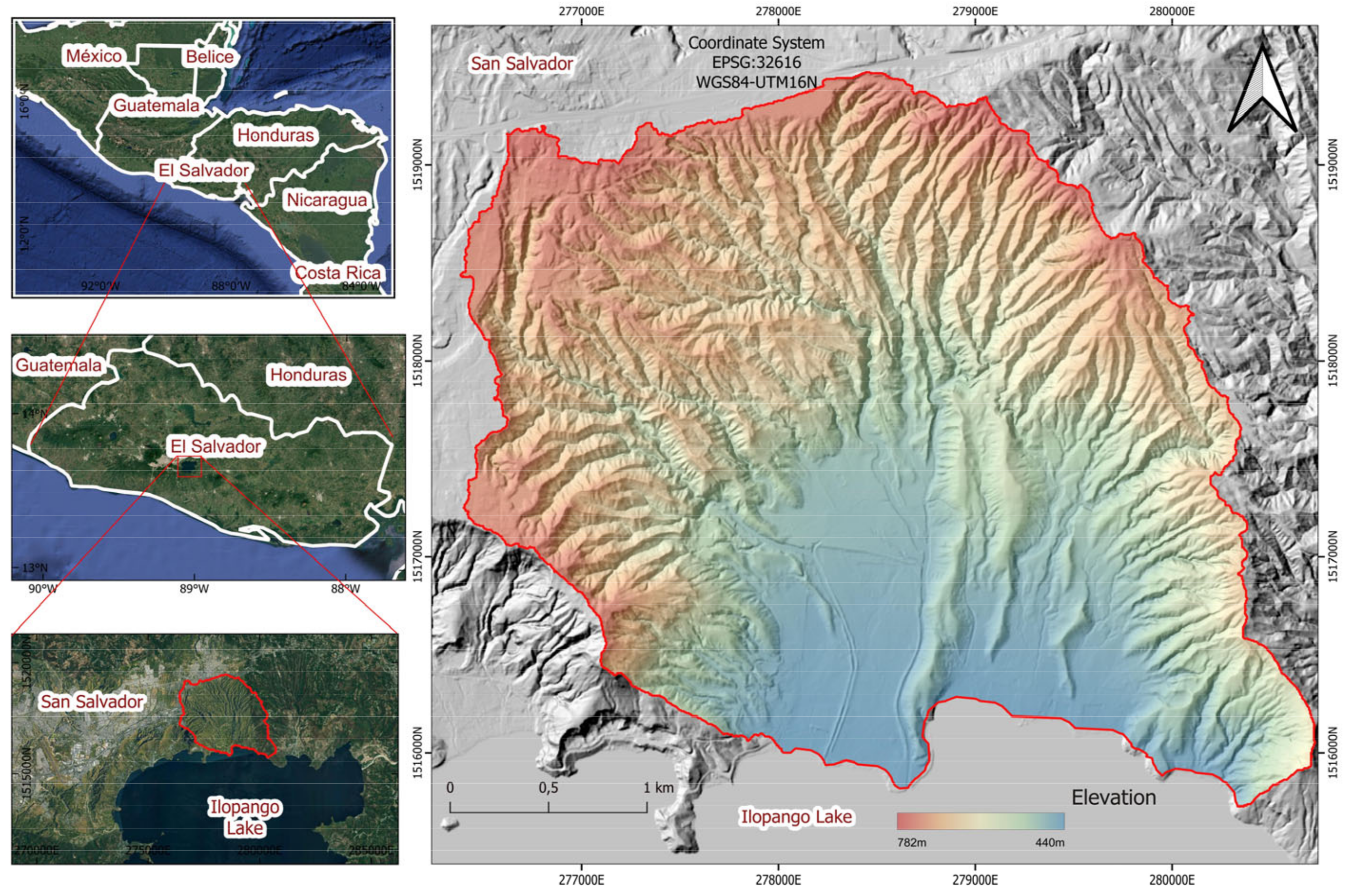
2. Study Area
3. Materials and Methods
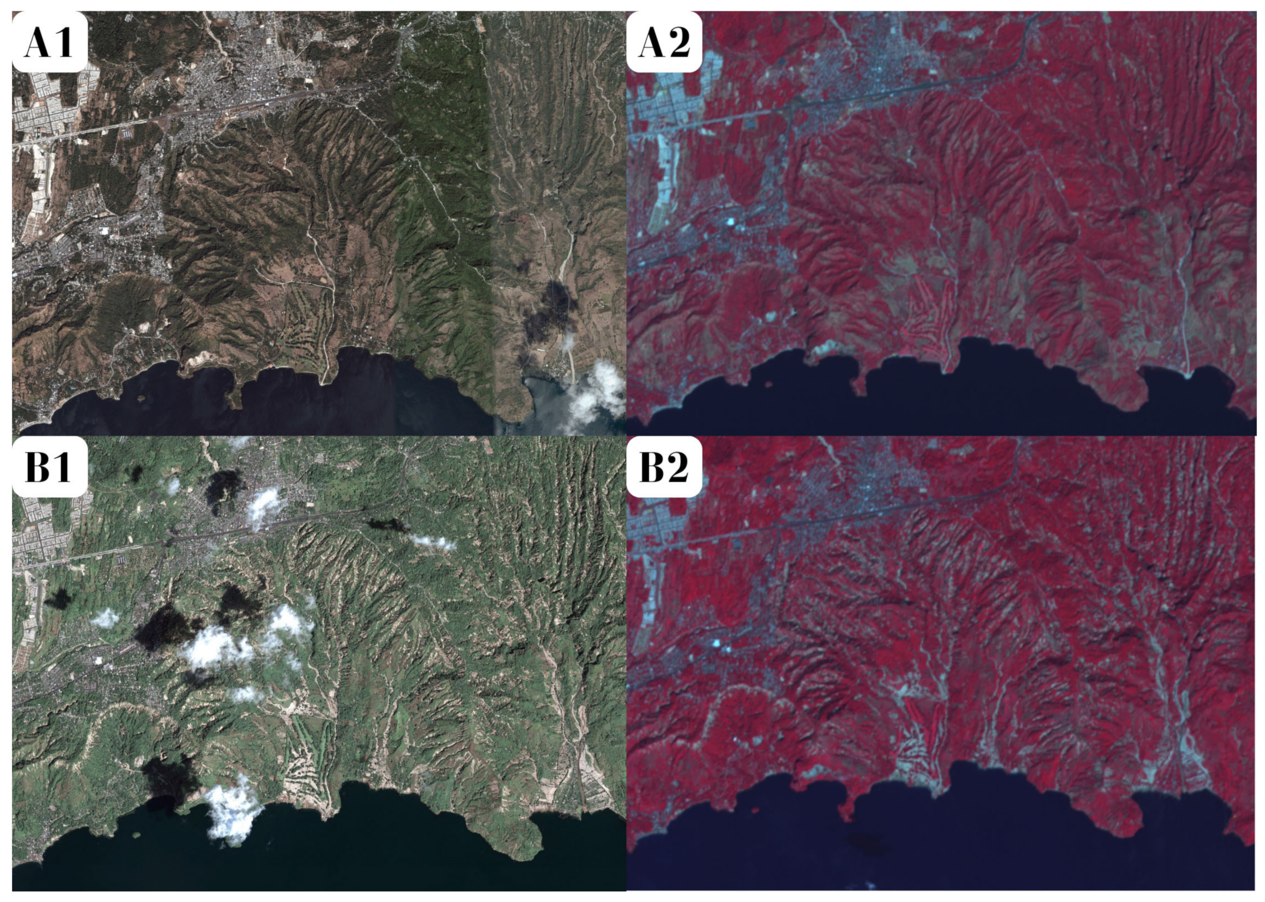
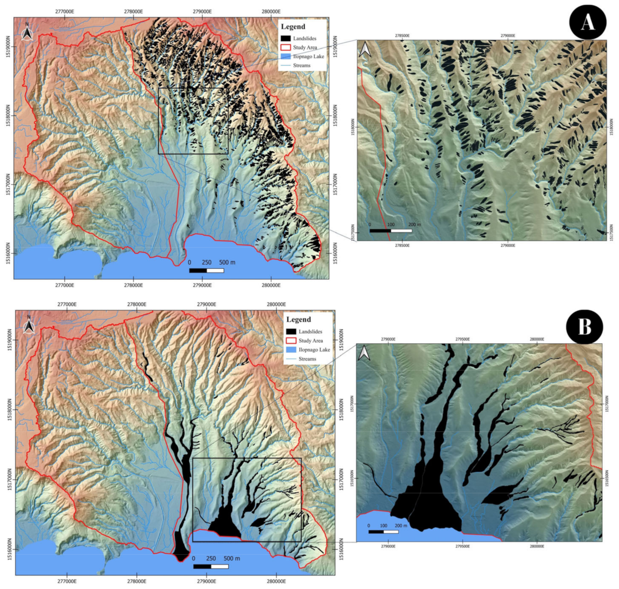
3.1. Landslide Mapping
3.2. Independent Variables

| Variable Name | Abbreviation | Description |
|---|---|---|
| Elevation | ELE | Altitude in meters. |
| Slope | SLO | Maximal rate of change of elevation values between horizontal and tangential planes [36]. |
| Plan curvature | PCV | Convergence and divergence of a normal section on the surface [37]. |
| Profile curvature | PRC | Relative deceleration or acceleration of flow according to a profile plane that cuts the surface [38]. |
| Longitudinal curvature | LCV | The intersection between the normal surface plane and the direction of the maximum gradient [36]. |
| Maximal curvature | MXC | Maximal value of the normal section curvature [39]. |
| Minimal curvature | MNC | Minimal value of the normal section curvature [39]. |
| Tangential curvature | TNC | Convex and concave shapes of a horizontal plane [40]. |
| Convergence index | CVI | Smoother plan curvature outcomes [41,42]. |
| Cross-sectional curvature | CROSS | Intersection of the normal surface with the maximum gradient direction [36]. |
| LS factor | LSF | Slope length using the slope gradient and the slope length factor (RUSLE) [43]. |
| Relative slope position | RSP | Define the surface in values ranging from downslope near zero (channel lines) to upslope upper values (ridge lines) [42,44]. |
| Stream power index | SPI | Flow erosion potential, considering the amount of water contributed by the upslope area and the velocity of the water flow [45]. |
| Topographic wetness index | TWI | Water accumulation tendency based on the specific catchment area and the local slope angle [46]. |
| Terrain ruggedness index | TRI | Measures the terrain heterogeneity between a grid cell and its eight neighbor grid cells [47]. |
| Topographic position index | TPI | Classification of the landscapes into slope position classes [48]. |
| Vertical distance to channel network | VDCN | It constitutes a theoretical surface regarding the channel lines (“base level”) [49]. |
| Northness | N | Cosine of slope aspect. |
| Eastness | E | Sine of slope aspect. |
| Variable Name | Abbreviation | ID | Model ID | Description |
|---|---|---|---|---|
| Lithology | LITO | 1 | LTL1 | Fm. Comalapa (c2)—acid pyroclastic |
| 2 | LTL2 | Fm. Comalapa (c1)—acid effusive | ||
| 3 | LTL3 | Fm. Tierras Blancas (s4)—pyroclastics | ||
| 4 | LTL4 | Alluvial deposits (Qf) | ||
| 5 | LTL5 | Gravity deposits (Qd) |
3.3. Dependent Variable
3.4. Univariate Analysis of Variables
3.5. Statistical Modeling
3.6. Validation Strategy
4. Results
4.1. Landslide Inventory
4.2. Variable Behavior on Each Dataset
4.3. Calibration of the Models
4.4. Validation of the Models
4.5. Landslide Susceptibility Maps
5. Discussion
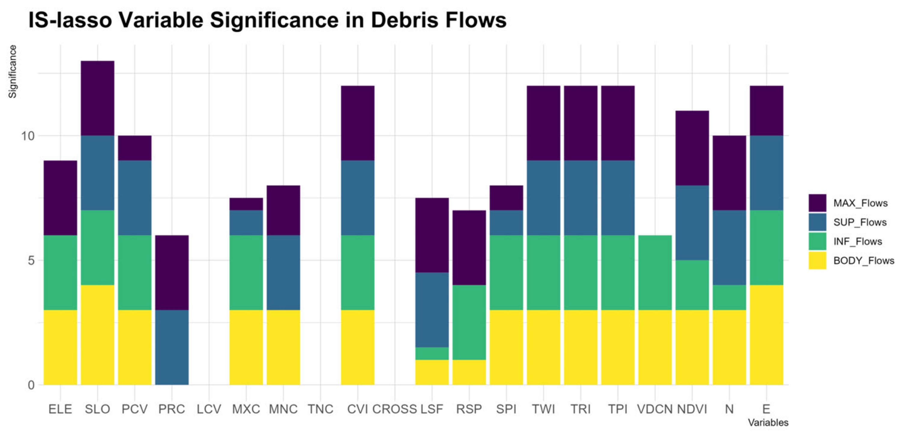
5.1. Comparing Variable Significance in IS Lasso and MARS Models
5.2. Impact of Sample Size Disparities
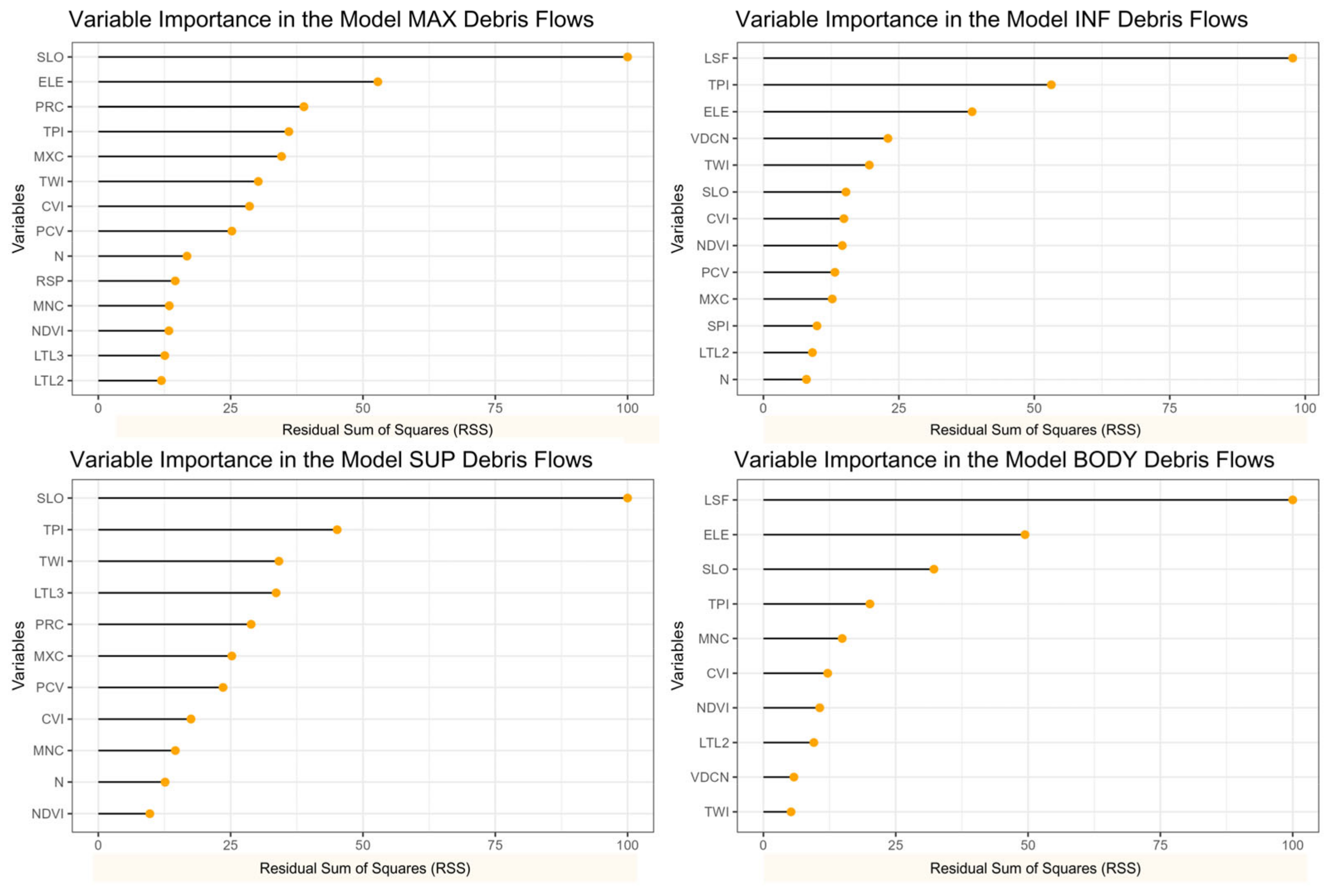
5.3. Deciphering Variable Importance
5.4. Comparing Results with Similar Studies
6. Concluding Remarks
Author Contributions
Funding
Data Availability Statement
Acknowledgments
Conflicts of Interest
References
- Brabb, E.E. Innovative Approaches to Landslide Hazard Mapping. In Proceedings of the 4th International Symposium on Landslides, Toronto, ON, Canada, 16–21 September 1984; Volume 1, pp. 307–324. [Google Scholar]
- Guzzetti, F.; Carrara, A.; Cardinali, M.; Reichenbach, P. Landslide hazard evaluation: A review of current techniques and their application in a multi-scale study, Central Italy. Geomorphology 1999, 31, 181–216. [Google Scholar] [CrossRef]
- Guzzetti, F. Landslide Hazard and Risk Assessment. Rheinische Friedrich-Wilhelms-Universität. 2005. Available online: https://geomorphology.irpi.cnr.it/Members/fausto/PhD-dissertation/Landslide_Hazard_and_Risk_Assessment.pdf (accessed on 15 June 2023).
- Lima, P.; Steger, S.; Glade, T. Counteracting flawed landslide data in statistically based landslide susceptibility modelling for very large areas: A national-scale assessment for Austria. Landslides 2021, 18, 3531–3546. [Google Scholar] [CrossRef]
- Heckmann, T.; Gegg, K.; Gegg, A.; Becht, M. Sample size matters: Investigating the effect of sample size on a logistic regression susceptibility model for debris flows. Nat. Hazards Earth Syst. Sci. 2014, 14, 259–278. [Google Scholar] [CrossRef]
- Heckmann, T.; Becht, M. Investigating the transferability of statistical disposition models for slope-type debris flows. Erdkunde 2009, 63, 19–33. [Google Scholar] [CrossRef]
- Remondo, J.; González-Díez, A.; Ramón, J.; de Terán, D.; Cendrero, A. Landslide Susceptibility Models Utilising Spatial Data Analysis Techniques. A Case Study from the Lower Deba Valley, Guipúzcoa (Spain). Nat. Hazards 2003, 30, 267–279. [Google Scholar] [CrossRef]
- van den Eeckhaut, M.; Vanwalleghem, T.; Poesen, J.; Govers, G.; Verstraeten, G.; Vandekerckhove, L. Prediction of landslide susceptibility using rare events logistic regression: A case-study in the Flemish Ardennes (Belgium). Geomorphology 2006, 76, 392–410. [Google Scholar] [CrossRef]
- Vargas-Cuervo, G.; Rotigliano, E.; Conoscenti, C. Prediction of debris-avalanches and -flows triggered by a tropical storm by using a stochastic approach: An application to the events occurred in Mocoa (Colombia) on 1 April 2017. Geomorphology 2019, 339, 31–43. [Google Scholar] [CrossRef]
- Dou, J.; Yunus, A.P.; Merghadi, A.; Shirzadi, A.; Nguyen, H.; Hussain, Y.; Avtar, R.; Chen, Y.; Pham, B.T.; Yamagishi, H. Different sampling strategies for predicting landslide susceptibilities are deemed less consequential with deep learning. Sci. Total Environ. 2020, 720, 137320. [Google Scholar] [CrossRef]
- Magliulo, P.; di Lisio, A.; Russo, F.; Zelano, A. Geomorphology and landslide susceptibility assessment using GIS and bivariate statistics: A case study in southern Italy. Nat. Hazards 2008, 47, 411–435. [Google Scholar] [CrossRef]
- Regmi, N.R.; Giardino, J.R.; McDonald, E.V.; Vitek, J.D. A comparison of logistic regression-based models of susceptibility to landslides in western Colorado, USA. Landslides 2014, 11, 247–262. [Google Scholar] [CrossRef]
- Vorpahl, P.; Elsenbeer, H.; Märker, M.; Schröder, B. How can statistical models help to determine driving factors of landslides? Ecol. Model. 2012, 239, 27–39. [Google Scholar] [CrossRef]
- Conoscenti, C.; Ciaccio, M.; Caraballo-Arias, N.A.; Gómez-Gutiérrez, Á.; Rotigliano, E.; Agnesi, V. Assessment of susceptibility to earth-flow landslide using logistic regression and multivariate adaptive regression splines: A case of the Belice River basin (western Sicily, Italy). Geomorphology 2015, 242, 49–64. [Google Scholar] [CrossRef]
- Hong, H.; Liu, J.; Bui, D.T.; Pradhan, B.; Acharya, T.D.; Pham, B.T.; Zhu, A.X.; Chen, W.; Ahmad, B. Bin. Landslide susceptibility mapping using J48 Decision Tree with AdaBoost, Bagging and Rotation Forest ensembles in the Guangchang area (China). Catena 2018, 163, 399–413. [Google Scholar] [CrossRef]
- Martinello, C.; Cappadonia, C.; Conoscenti, C.; Agnesi, V.; Rotigliano, E. Optimal slope units partitioning in landslide susceptibility mapping. J. Maps 2021, 17, 152–162. [Google Scholar] [CrossRef]
- Alonso-Henar, J.; Álvarez-Gómez, J.A.; Martínez-Díaz, J.J. Neogene-quaternary evolution from transpressional to transtensional tectonics in Northern Central America controlled by cocos: Caribbean subduction coupling change. J. Iber. Geol. 2017, 43, 519–538. [Google Scholar] [CrossRef]
- Suñe-Puchol, I.; Aguirre-Díaz, G.J.; Dávila-Harris, P.; Miggins, D.P.; Pedrazzi, D.; Costa, A.; Ortega-Obregón, C.; Lacan, P.; Hernández, W.; Gutiérrez, E. The Ilopango caldera complex, El Salvador: Origin and early ignimbrite-forming eruptions of a graben/pull-apart caldera structure. J. Volcanol. Geotherm. Res. 2019, 371, 1–19. [Google Scholar] [CrossRef]
- DeMets, C. A new estimate for present-day Cocos-Caribbean plate motion: Implications for slip along the Central American volcanic arc. Geophys. Res. 2001, 28, 4043–4046. [Google Scholar] [CrossRef]
- Dixon, T. GPS measurement of relative motion of the Cocos and Caribbean plates and strain accumulation across the Middle America trench. Geophys. Res. 1993, 20, 2167–2170. Available online: https://agupubs.onlinelibrary.wiley.com/doi/abs/10.1029/93GL02415 (accessed on 2 May 2023). [CrossRef]
- Martínez-Díaz, J.; Alvarez-Gómez, J.; Benito, B.; Hernández, D. Triggering of destructive earthquakes in El Salvador. Geology 2004, 32, 65–68. Available online: https://pubs.geoscienceworld.org/ssa/geology/article/32/1/65/129218 (accessed on 2 May 2023). [CrossRef]
- Agostini, S.; Corti, G.; Doglioni, C.; Carminati, E.; Innocenti, F.; Tonarini, S.; Montanari, D. Tectonic and magmatic evolution of the active volcanic front in El Salvador: Insight into the Berlín and Ahuachapán geothermal areas. Geothermics 2006, 35, 368–408. [Google Scholar] [CrossRef]
- Canora, C.; Villamor, P.; Martínez-Díaz, J.J.; Berryman, K.R.; Álvarez-Gómez, J.A.; Capote, R.; Hernández, W. Paleoseismic analysis of the San Vicente segment of the El Salvador Fault Zone, El Salvador, Central America. Geol. Acta 2012, 10, 103–123. Available online: https://www.redalyc.org/pdf/505/50524522002.pdf (accessed on 2 May 2023).
- Corti, G.; Carminati, E.; Mazzarini, F.; Garcia, M.O. Active strike-slip faulting in El Salvador, central America. Geology 2005, 33, 989–992. [Google Scholar] [CrossRef]
- Funk, J.; Mann, P.; McIntosh, K.; Stephens, J. Cenozoic tectonics of the Nicaraguan depression, Nicaragua, and Median Trough, El Salvador, based on seismic-reflection profiling and remote-sensing data. Geol. Soc. Am. Bull. 2009, 121, 1491–1521. Available online: https://pubs.geoscienceworld.org/gsa/gsabulletin/article-abstract/121/11-12/1491/2345 (accessed on 2 May 2023). [CrossRef]
- Calderón-Cucunubá, L.P. El uso de la Geomática en la Caracterización Geométrica y Morfológica de la Caldera de Ilopango, “República del Salvador”. Master’s Dissertation, Universidad Autónoma de San Luis de Potosí, San Luis Potosí, Mexico, 2018. Available online: https://repositorioinstitucional.uaslp.mx/xmlui/bitstream/handle/i/5686/Tesis_Laura%20Paola%20Calderon%20Cucunuba%20%281%29.pdf?sequence=1&isAllowed=y (accessed on 2 May 2023).
- Suñe-Puchol, I.; Aguirre-Díaz, G.J.; Pedrazzi, D.; Dávila-Harris, P.; Miggins, D.P.; Costa, A.; Ortega-Obregón, C.; Lacan, P.; Gutierrez, E.; Hernández, W. The Ilopango caldera complex, El Salvador: Stratigraphic revision of the complete eruptive sequence and recurrence of large explosive eruptions. J. Volcanol. Geotherm. Res. 2019, 374, 100–119. [Google Scholar] [CrossRef]
- Kattan, C.; Menjívar, L.; Molina, G.; Peñate, Y.; Estrada, A.; Moran, I.; Cañas, A. Informe Nacional del Estado de los Riesgos y Vulnerabilidades. Ministerio de Medio Ambiente y Recursos Naturales (MARN). 2017. Available online: https://srt.snet.gob.sv/tallerdivulgacion/RiesgoSismico/1.%20Informe%20Nacional%20del%20Estado%20de%20los%20Riesgos%20y%20Vulnerabilidad-%202017.pdf (accessed on 2 May 2023).
- Rabby, Y.W.; Li, Y. An integrated approach to map landslides in Chittagong Hilly Areas, Bangladesh, using Google Earth and field mapping. Landslides 2019, 16, 633–645. [Google Scholar] [CrossRef]
- Costanzo, D.; Chacón, J.; Conoscenti, C.; Irigaray, C.; Rotigliano, E. Forward logistic regression for earth-flow landslide susceptibility assessment in the Platani river basin (southern Sicily, Italy). Landslides 2014, 11, 639–653. [Google Scholar] [CrossRef]
- Rotigliano, E.; Martinello, C.; Hernandéz, M.A.; Agnesi, V.; Conoscenti, C. Predicting the landslides triggered by the 2009 96E/Ida tropical storms in the Ilopango caldera area (El Salvador, CA): Optimizing MARS-based model building and validation strategies. Environ. Earth Sci. 2019, 78, 210. [Google Scholar] [CrossRef]
- Conrad, O.; Bechtel, B.; Bock, M.; Dietrich, H.; Fischer, E.; Gerlitz, L.; Wehberg, J.; Wichmann, V.; Böhner, J. System for Automated Geoscientific Analyses (SAGA) v. 2.1.4. Geosci. Model Dev. 2015, 8, 1991–2007. [Google Scholar] [CrossRef]
- Weber, H.S.; Wiesemann, G.; Wittekindt, H. Mapa Geológico General de la República de El Salvador 1:500,000/Geologische Übersichtskarte der Republik El Salvador 1:500,000 (After Geological Maps 1:100,000-1967-74)-Bundesanstalt für Bodenforschung; Bundesanstalt für Bodenforschung: Hannover, Germany, 1974. [Google Scholar]
- Rouse, J.W., Jr.; Haas, R.H.; Schell, J.A.; Deering, D.W. Third Earth Resources Technology Satellite-1 Symposium. In Proceedings of the Third Symposium on Significant Results Obtained from the first Earth Resources, Washington, DC, USA, 10–14 December 1973; Goddard Space Flight Center, Scientific and Technical Information Office, National Aeronautics and Space Administration: Washington, DC, USA, 1974; Volume 351, p. 309. [Google Scholar]
- Jackson, R.D.; Huete, A.R. Interpreting vegetation indices. Prev. Vet. Med. 1991, 11, 185–200. [Google Scholar] [CrossRef]
- Zevenbergen, L.W.; Thorne, C.R. Quantitative analysis of land surface topography. Earth Surf. Process. Landf. 1987, 12, 47–56. [Google Scholar] [CrossRef]
- Dikau, R. Entwurf einer geomorphographisch-analytischen Systematik von Reliefeinheiten. Heidelb. Geogr. Bausteine 1988, 5, 45. [Google Scholar]
- Shary, P.A. Land surface in gravity points classification by a complete system of curvatures. Math. Geol. 1995, 27, 373–390. [Google Scholar] [CrossRef]
- Hengl, T.; Reuter, H.I. (Eds.) Geomorphometry: Concepts, Software, Applications, Developments in Soil Science; Elsevier: Amsterdam, The Netherlands, 2008; Volume 33. [Google Scholar]
- Shary, P.A.; Sharaya, L.S.; Mitusov, A.V. Fundamental quantitative methods of land surface analysis. Geoderma 2002, 107, 1–32. [Google Scholar] [CrossRef]
- Köthe, R.; Gehrt, E.; Böhner, J. Automatische Reliefanalyse für geowissenschaftliche Anwendungen-derzeitiger Stand und Weiterentwicklungen des Programms SARA. Arbeitshefte Geol. 1996, 1, 31–37. [Google Scholar]
- Watkins, R.L. Terrain Metrics and Landscape Characterization from Bathymetric Data: SAGA GIS Methods and Command Sequences. 2019. Available online: https://ftp.soest.hawaii.edu/pibhmc/website/webdocs/documentation/linkages_project_methods_final.pdf (accessed on 10 July 2023).
- Desmet, P.J.J.; Govers, G. A GIS procedure for automatically calculating the USLE LS factor on topographically complex landscape units. J. Soil Water Conserv. 1996, 51, 427–433. Available online: https://www.jswconline.org/content/51/5/427.short (accessed on 10 July 2023).
- Bock, M.; Böhner, J.; Conrad, O.; Köthe, R.; Ringeler, A. XV. Methods for creating functional soil databases and applying digital soil mapping with SAGA GIS. JRC Sci. Tech. Rep. 2007, 149–163. Available online: https://www.researchgate.net/publication/267706527_XV_Methods_for_creating_Functional_Soil_Databases_and_applying_Digital_Soil_Mapping_with_SAGA_GIS (accessed on 10 July 2023).
- Gruber, S.; Peckham, S. Chapter 7 Land-Surface Parameters and Objects in Hydrology. Dev. Soil Sci. 2009, 33, 171–194. [Google Scholar] [CrossRef]
- Quinn, P.F.; Beven, K.J.; Lamb, R. The in(a/tan/β) index: How to calculate it and how to use it within the topmodel framework. Hydrol. Process. 1995, 9, 161–182. [Google Scholar] [CrossRef]
- Riley, S.J.; DeGloria, S.D.; Elliot, R. Index that quantifies topographic heterogeneity. Intermt. J. Sci. 1999, 5, 23–27. [Google Scholar]
- Weiss, A. Topographic position and landforms analysis. Poster Presentation. In Proceedings of the ESRI User Conference, San Diego, CA, USA, 9–13 July 2001; Volume 64, pp. 227–245. [Google Scholar]
- Bock, M.; Köthe, R. Predicting the depth of hydromorphic soil characteristics influenced by ground water. SAGA Second. Out 2008, 19, 13–22. Available online: https://www.researchgate.net/publication/267553405 (accessed on 10 July 2023).
- Hungr, O.; Leroueil, S.; Picarelli, L. The Varnes classification of landslide types, an update. Landslides 2014, 11, 167–194. [Google Scholar] [CrossRef]
- Cilluffo, G.; Sottile, G.; La Grutta, S.; Muggeo, V.M.R. The Induced Smoothed lasso: A practical framework for hypothesis testing in high dimensional regression. Stat. Methods Med. Res. 2020, 29, 765–777. [Google Scholar] [CrossRef] [PubMed]
- R Core Team. R: A Language and Environment for Statistical Computing (R-4.3.1). R Foundation for Statistical Computing. 2021. Available online: https://www.R-project.org/ (accessed on 10 July 2023).
- Friedman, J.H. Estimating Functions of Mixed Ordinal and Categorical Variables Using Adaptive Splines. 1991. Available online: https://apps.dtic.mil/sti/citations/ADA590939 (accessed on 10 July 2023).
- Chung, C.J.F.; Fabbri, A.G. Validation of spatial prediction models for landslide hazard mapping. Nat. Hazards 2003, 30, 451–472. [Google Scholar] [CrossRef]
- Tien Bui, D.; Tuan, T.A.; Klempe, H.; Pradhan, B.; Revhaug, I. Spatial prediction models for shallow landslide hazards: A comparative assessment of the efficacy of support vector machines, artificial neural networks, kernel logistic regression, and logistic model tree. Landslides 2016, 13, 361–378. [Google Scholar] [CrossRef]
- Milborrow, S. Notes on the Earth Package. 2021. Available online: http://mtweb.cs.ucl.ac.uk/mus/lib/R/earth/doc/earth-notes.pdf (accessed on 10 July 2023).
- Catani, F.; Lagomarsino, D.; Segoni, S.; Tofani, V. Landslide susceptibility estimation by random forests technique: Sensitivity and scaling issues. Nat. Hazards Earth Syst. Sci. 2013, 13, 2815–2831. [Google Scholar] [CrossRef]
- Reichenbach, P.; Rossi, M.; Malamud, B.D.; Mihir, M.; Guzzetti, F. A review of statistically-based landslide susceptibility models. Earth Sci. Rev. 2018, 180, 60–91. [Google Scholar] [CrossRef]


| Debris Flow Database | Debris Flood Database | |||||||||||||||
|---|---|---|---|---|---|---|---|---|---|---|---|---|---|---|---|---|
| Variable | MAX | Imp | SUP | Imp | INF | Imp | BODY | Imp | MAX | Imp | SUP | Imp | INF | Imp | BODY | Imp |
| ELE | 7.12 × 10⁻⁴ | *** | 8.33 × 10⁻¹ | 6.22 × 10⁻¹⁹ | *** | 7.68 × 10−76 | *** | 0.0100404 | * | 7.55 × 10−90 | *** | 5.29 × 10−50 | *** | 0.00 × 10+00 | NA | |
| SLO | 3.15 × 10⁻¹⁹ | *** | 7.71 × 10−38 | *** | 6.68 × 10−70 | *** | 0.00 × 10+00 | NA | 0.091878 | . | 8.12 × 10⁻⁴ | *** | 2.22 × 10⁻¹ | 3.08 × 10⁻¹ | ||
| PCV | 1.69 × 10⁻² | * | 2.16 × 10⁻¹⁰ | *** | 6.37 × 10⁻⁵ | *** | 5.98 × 10⁻⁹ | *** | 0.9999999 | 6.65 × 10⁻¹ | 6.55 × 10⁻¹ | 1.00 × 10+00 | ||||
| PRC | 1.45 × 10⁻¹² | *** | 8.82 × 10⁻²⁰ | *** | 1.36 × 10⁻¹ | 4.01 × 10⁻¹ | 0.9999992 | 1.00 × 10+00 | 1.00 × 10+00 | 1.00 × 10+00 | ||||||
| LCV | 8.20 × 10⁻¹ | 2.41 × 10⁻¹ | 7.45 × 10⁻¹ | 1.00 × 10+00 | 0.9999959 | 6.02 × 10⁻³ | ** | 1.00 × 10+00 | 9.31 × 10⁻² | . | ||||||
| MXC | 6.26 × 10⁻² | . | 2.76 × 10⁻² | * | 5.80 × 10⁻⁵ | *** | 2.67 × 10⁻¹⁸ | *** | 0.9999974 | 5.99 × 10⁻¹ | 1.00 × 10+00 | 6.51 × 10⁻¹ | ||||
| MNC | 3.67 × 10⁻³ | ** | 3.31 × 10⁻¹⁰ | *** | 4.16 × 10⁻¹ | 1.03 × 10⁻²³ | *** | 0.9999997 | 1.00 × 10+00 | 1.00 × 10+00 | 1.00 × 10+00 | |||||
| TNC | 1.00 × 10+00 | 1.00 × 10+00 | 7.62 × 10⁻¹ | 1.00 × 10+00 | 0.9999995 | 1.00 × 10+00 | 1.00 × 10+00 | 1.00 × 10+00 | ||||||||
| CVI | 9.56 × 10⁻¹² | *** | 6.03 × 10⁻⁴ | *** | 6.06 × 10−43 | *** | 4.40 × 10⁻⁸ | *** | 0.0025186 | ** | 9.03 × 10⁻¹ | 2.27 × 10⁻¹ | 4.33 × 10⁻⁶ | *** | ||
| CROSS | 7.03 × 10⁻¹ | 2.93 × 10⁻¹ | 1.00 × 10+00 | 1.00 × 10+00 | 0.9999983 | 3.75 × 10⁻¹ | 1.00 × 10+00 | 9.92 × 10⁻¹ | ||||||||
| LSF | 8.00 × 10⁻⁵ | *** | 1.79 × 10⁻⁵ | *** | 5.70 × 10⁻² | . | 4.91 × 10⁻² | * | 0.26371 | 3.19 × 10⁻¹ | 2.46 × 10⁻¹ | 3.58 × 10⁻⁵ | *** | |||
| RSP | 2.20 × 10⁻⁴ | *** | 7.38 × 10⁻¹ | 1.98 × 10⁻⁴ | *** | 1.86 × 10⁻² | * | 0.7148685 | 1.47 × 10⁻⁴ | *** | 2.17 × 10⁻³³ | *** | 1.84 × 10−92 | *** | ||
| SPI | 3.59 × 10⁻² | * | 1.82 × 10⁻² | * | 1.72 × 10⁻⁶ | *** | 1.07 × 10⁻¹² | *** | 0.5813285 | 6.89 × 10⁻¹ | 1.27 × 10⁻⁴ | *** | 1.37 × 10⁻² | * | ||
| TWI | 2.93 × 10⁻⁶ | *** | 7.19 × 10⁻¹¹ | *** | 1.09 × 10⁻⁶ | *** | 1.59 × 10⁻³² | *** | 0.7847661 | 1.05 × 10⁻² | * | 9.79 × 10⁻¹³ | *** | 1.24 × 10−46 | *** | |
| TRI | 8.15 × 10⁻²⁰ | *** | 1.37 × 10−42 | *** | 2.38 × 10⁻²⁷ | *** | 3.17 × 10−252 | *** | 0.2310383 | 1.54 × 10⁻³ | ** | 7.20 × 10⁻¹ | 1.11 × 10⁻¹ | |||
| TPI | 1.94 × 10⁻²⁶ | *** | 2.31 × 10−67 | *** | 2.91 × 10−125 | *** | 2.50 × 10⁻²⁰ | *** | 0.9782402 | 3.64 × 10−37 | *** | 8.11 × 10⁻³ | ** | 2.56 × 10−89 | *** | |
| VDCN | 8.60 × 10⁻¹ | 1.11 × 10⁻¹ | 4.84 × 10−47 | *** | 1.50 × 10−83 | *** | 0.2114126 | 4.18 × 10⁻² | * | 7.94 × 10⁻² | . | 1.57 × 10⁻²² | *** | |||
| NDVI | 7.46 × 10⁻⁵ | *** | 1.36 × 10⁻⁴ | *** | 1.57 × 10⁻³ | ** | 9.36 × 10⁻³³ | *** | 0.9999999 | 3.96 × 10⁻⁷ | *** | 1.98 × 10⁻⁶ | *** | 7.92 × 10−81 | *** | |
| N | 1.53 × 10⁻¹⁵ | *** | 5.96 × 10⁻¹⁴ | *** | 2.63 × 10⁻² | * | 2.79 × 10⁻⁶ | *** | 0.9038835 | 4.53 × 10⁻¹ | 2.27 × 10⁻¹ | 1.61 × 10⁻¹ | ||||
| E | 5.37 × 10⁻³ | ** | 8.02 × 10²⁰ | *** | 1.59 × 10⁻¹⁴ | *** | 0.00 × 10+00 | NA | 0.1585544 | 1.99 × 10⁻³ | ** | 1.07 × 10⁻¹⁹ | *** | 4.52 × 10−85 | *** | |
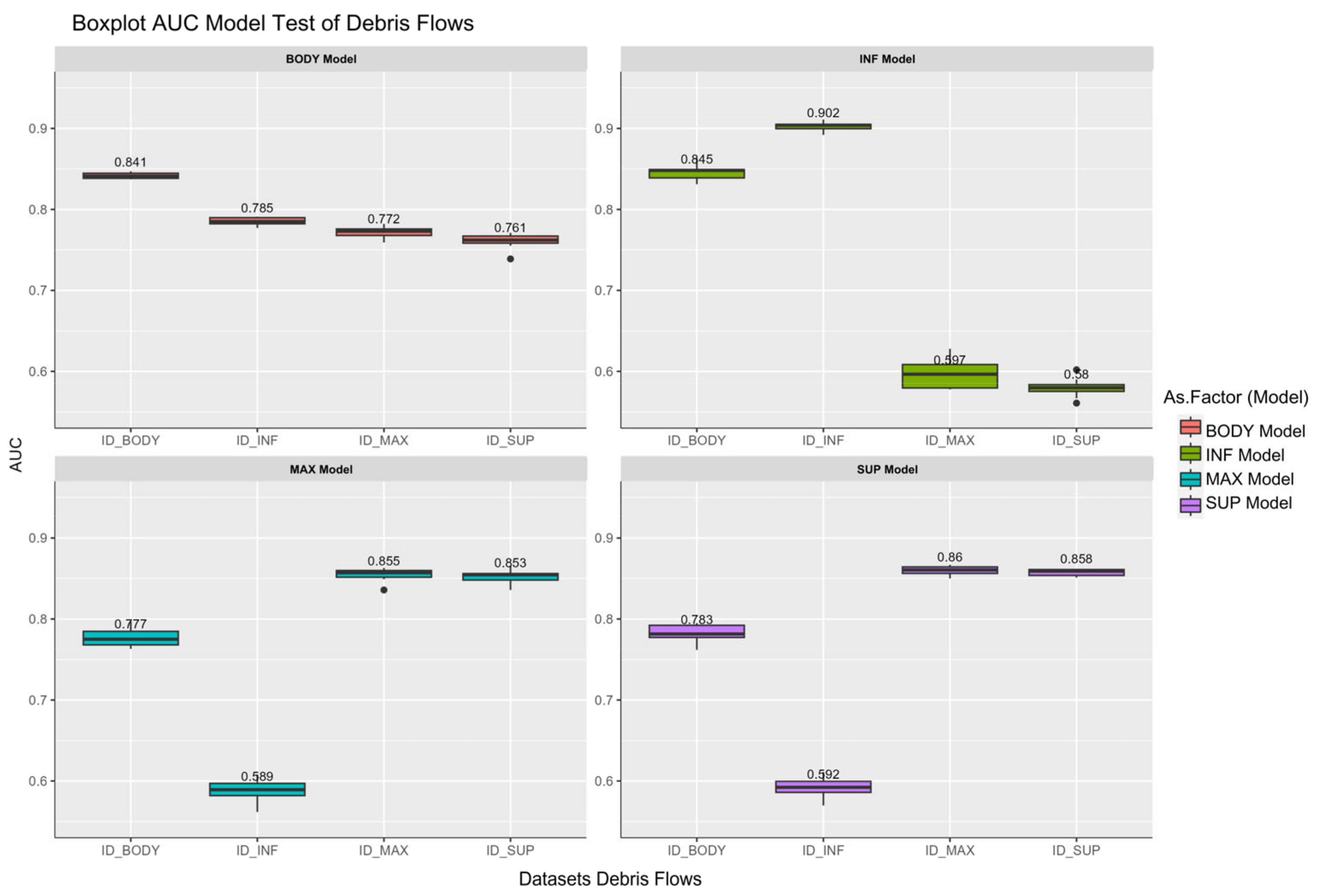
| AUC_Test_Database_Debris Flows | AUC_Train_Database_Debris Flows | ||||||||
|---|---|---|---|---|---|---|---|---|---|
| Dataset | BODY | INF | MAX | SUP | BODY | INF | MAX | SUP | |
| BODY Model | Mean | 0.841 | 0.785 | 0.772 | 0.761 | 0.840 | 0.785 | 0.766 | 0.756 |
| SD | 0.0037 | 0.005 | 0.007 | 0.0093 | 0.0014 | 0.0024 | 0.0078 | 0.003 | |
| INF Model | Mean | 0.845 | 0.902 | 0.597 | 0.580 | 0.842 | 0.905 | 0.592 | 0.575 |
| SD | 0.0095 | 0.0056 | 0.0182 | 0.0114 | 0.003 | 0.0023 | 0.0133 | 0.0088 | |
| MAX Model | Mean | 0.777 | 0.589 | 0.855 | 0.853 | 0.780 | 0.591 | 0.864 | 0.855 |
| SD | 0.0115 | 0.0137 | 0.0079 | 0.0086 | 0.0052 | 0.0085 | 0.004 | 0.0051 | |
| SUP Model | Mean | 0.783 | 0.592 | 0.860 | 0.858 | 0.782 | 0.588 | 0.859 | 0.861 |
| SD | 0.0106 | 0.0127 | 0.0052 | 0.0042 | 0.0039 | 0.0084 | 0.004 | 0.0031 | |
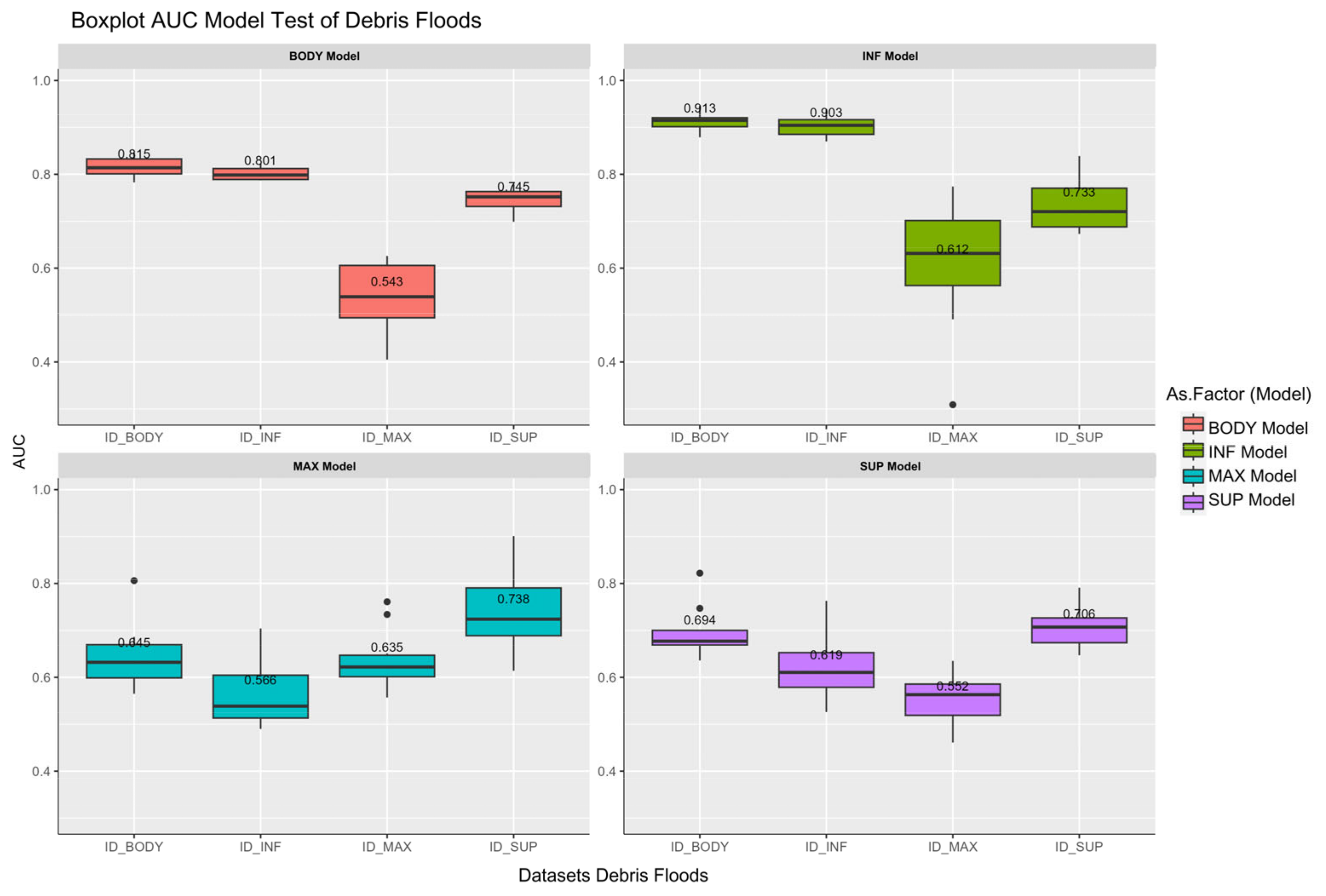
| AUC_Test_Database_Debris Floods | AUC_Train_Database_Debris Floods | ||||||||
|---|---|---|---|---|---|---|---|---|---|
| Dataset | BODY | INF | MAX | SUP | BODY | INF | MAX | SUP | |
| BODY Model | Mean | 0.815 | 0.801 | 0.543 | 0.745 | 0.842 | 0.802 | 0.544 | 0.743 |
| SD | 0.0213 | 0.0131 | 0.0725 | 0.0266 | 0.0068 | 0.0127 | 0.071 | 0.0129 | |
| INF Model | Mean | 0.913 | 0.903 | 0.612 | 0.733 | 0.899 | 0.935 | 0.659 | 0.747 |
| SD | 0.0181 | 0.0242 | 0.1369 | 0.0548 | 0.0119 | 0.0088 | 0.0942 | 0.0266 | |
| MAX Model | Mean | 0.645 | 0.566 | 0.636 | 0.738 | 0.651 | 0.584 | 0.685 | 0.729 |
| SD | 0.0685 | 0.07 | 0.0668 | 0.0818 | 0.0523 | 0.0357 | 0.068 | 0.069 | |
| SUP Model | Mean | 0.694 | 0.619 | 0.552 | 0.706 | 0.702 | 0.631 | 0.554 | 0.813 |
| SD | 0.0554 | 0.0678 | 0.0509 | 0.0421 | 0.0255 | 0.0281 | 0.0433 | 0.0141 | |
Disclaimer/Publisher’s Note: The statements, opinions and data contained in all publications are solely those of the individual author(s) and contributor(s) and not of MDPI and/or the editor(s). MDPI and/or the editor(s) disclaim responsibility for any injury to people or property resulting from any ideas, methods, instructions or products referred to in the content. |
© 2025 by the authors. Licensee MDPI, Basel, Switzerland. This article is an open access article distributed under the terms and conditions of the Creative Commons Attribution (CC BY) license (https://creativecommons.org/licenses/by/4.0/).
Share and Cite
Calderon-Cucunuba, L.P.; Argueta-Platero, A.A.; Fernández, T.; Mercurio, C.; Martinello, C.; Rotigliano, E.; Conoscenti, C. Predicting Landslide Deposit Zones: Insights from Advanced Sampling Strategies in the Ilopango Caldera, El Salvador. Land 2025, 14, 269. https://doi.org/10.3390/land14020269
Calderon-Cucunuba LP, Argueta-Platero AA, Fernández T, Mercurio C, Martinello C, Rotigliano E, Conoscenti C. Predicting Landslide Deposit Zones: Insights from Advanced Sampling Strategies in the Ilopango Caldera, El Salvador. Land. 2025; 14(2):269. https://doi.org/10.3390/land14020269
Chicago/Turabian StyleCalderon-Cucunuba, Laura Paola, Abel Alexei Argueta-Platero, Tomás Fernández, Claudio Mercurio, Chiara Martinello, Edoardo Rotigliano, and Christian Conoscenti. 2025. "Predicting Landslide Deposit Zones: Insights from Advanced Sampling Strategies in the Ilopango Caldera, El Salvador" Land 14, no. 2: 269. https://doi.org/10.3390/land14020269
APA StyleCalderon-Cucunuba, L. P., Argueta-Platero, A. A., Fernández, T., Mercurio, C., Martinello, C., Rotigliano, E., & Conoscenti, C. (2025). Predicting Landslide Deposit Zones: Insights from Advanced Sampling Strategies in the Ilopango Caldera, El Salvador. Land, 14(2), 269. https://doi.org/10.3390/land14020269