Article

Environmental Justice in the Green Transition of Rural Post-Industrial Waterfronts: A Villagers’ Perspective—A Case Study of the Waterfront Area in Jiangsu Province, China

1
Gold Mantis School of Architecture, Soochow University, Suzhou 215127, China
2
School of Architecture and Urban Planning, Beijing University of Civil Engineering and Architecture, Beijing 100044, China
*
Author to whom correspondence should be addressed.
These authors contributed equally to this work.
Land 2025, 14(11), 2204; https://doi.org/10.3390/land14112204
Submission received: 19 September 2025 / Revised: 13 October 2025 / Accepted: 14 October 2025 / Published: 6 November 2025

Abstract

The construction of post-industrial landscapes is increasingly regarded as an important pathway for promoting urban sustainability. However, limited attention has been given to the interconnections between post-industrial landscapes and local villagers in rural contexts. From the perspective of environmental justice, the ecological and cultural-tourism goals of post-industrial landscapes may be mismatched with villagers’ place-based needs. This study examines a typical rural post-industrial waterfront area in China to analyze villagers’ environmental justice. Representative project photographs were collected, and villagers’ perceptions were obtained through questionnaires and semi-structured interviews, yielding 98 valid responses (95% response rate). Quantitative measurements of landscape characteristics were combined with pairwise preference evaluations, and the analysis applied the framework of recognition, participatory, and distributive justice. A discrete choice model (DCM) and spatial analysis were then employed to explore the relationships. Quantitative analysis showed that natural vegetation, plazas, industrial heritage, and pedestrian paths had negative effects on villagers’ recognition (β = −0.36 to −0.18), whereas hardscape had a strong positive effect (β = 0.94). Moreover, spatial analysis indicated localized patterns of environmental injustice, highlighting uneven distribution of landscape benefits across the site. Semi-structured interviews revealed villagers’ priorities across landscape design, amenities, local livelihoods, and project implementation, highlighting the importance of safer, more functional, and well-managed spaces. Collectively, these findings underscore the importance of inclusive planning and design strategies that integrate ecological, cultural, and recreational considerations, thereby supporting the sustainable renewal of rural post-industrial waterfronts.

1. Introduction

Post-industrial landscapes have evolved from industrial peripheries once characterized by pollution and spatial segregation into forms of blue–green infrastructure that integrate ecological restoration, public recreation, and cultural memory. As such, they have become a prominent topic in international research on sustainable landscape architecture planning and post-industrial regeneration projects [1,2]. Canals constitute a representative type of post-industrial waterfront, where docks, factories, and warehouses are frequently redeveloped into high-quality blue–green waterfront landscapes, thereby reoriented toward recreational and ecological functions [3,4]. To date, this transformation has been concentrated primarily in urban areas, supported by a wide range of projects and studies [5,6], and is widely recognized as a key pathway toward urban and regional sustainability. By contrast, comparable processes within rural contexts have received considerably less attention.
In rural regions, the green transformation of industrial areas encompasses objectives such as ecological restoration, environmental pollution control, and the reallocation of land reserves for future agricultural development or other green industries [7]. In certain rural areas of China, local governments have implemented a policy framework known as the “Three Priorities and Three Guarantees” (San You San Bao), which emphasizes optimizing spatial layout, land-use structure, and development quality (“three priorities”), while ensuring economic growth, ecological protection, and social well-being (“three guarantees”) [8]. This framework serves as a guiding principle for balancing rural industrial transformation with ecological restoration and community interests. Meanwhile, under the influence of China’s Rural Revitalization Strategy [9,10], such transformations are frequently coupled with tourism development goals, seeking to attract visitors through environmental enhancement and landscape design, thereby advancing rural tourism [11,12]. However, land-use transitions that disregard villagers’ benefits—such as indiscriminate ecological projects or excessive tourism development—tend to privilege the interests of governments, developers, and tourists, or reduce the countryside to a sacrificial space for solving urban problems, thus generating environmental injustice [13,14,15]. Although villagers are primary stakeholders in rural land redevelopment, their environmental justice concerns are frequently overlooked in these projects [16]. During sustainable transformation processes, environmental justice may emerge as a significant constraint [17,18]. Differences in lifestyles, production practices, land-use patterns, and social backgrounds result in divergent perceptions of environmental justice between rural and urban residents [19], highlighting the need for dedicated investigation and research in this type of project.
Existing studies have generated substantial insights into environmental justice within post-industrial landscapes in urban contexts [20]. However, critical gaps remain in rural settings. First, there is a potential mismatch between the design objectives of rural green spaces and the needs of local residents. Previous research has shown that tourist-oriented landscape interventions, which privilege external preferences, may stimulate rural tourism development or gentrification, thereby diverging from residents’ actual demands [21]. Furthermore, the neglect of rural-specific characteristics has prompted criticisms of excessive urbanization, whereby the aesthetic values and functional expectations of urban residents are imposed upon villagers [22,23]. Additionally, rural spaces under regional ecological management may be relegated to the role of sacrificial areas, characterized by low investment and maintenance, and transformed into biodiversity conservation zones that lack conditions suitable for habitation, diverging from villagers’ expectations for high-quality living environments [24]. Second, villagers’ participation in rural projects is constrained, encompassing limited involvement in early-stage decision-making as well as restricted access to information and opportunities for feedback during later stages. Many emerging channels of public participation, such as new media, remain largely inaccessible to villagers [25]. Consequently, villagers’ voices are often marginalized and overlooked within the broader societal context [26]. Third, the segmental heterogeneity of linear waterfront corridors and the resulting distributive differences have not been systematically characterized. Long-distance, narrow-section morphologies tend to generate pronounced gradients in accessibility, thereby amplifying along-line spatial inequalities [27]. Finally, from a methodological perspective, there remains a lack of operationalizable frameworks that integrate environmental justice, landscape projects, and theories of landscape planning, design, and management into a unified identification approach, particularly in rural contexts where respondents’ educational levels are limited and survey burden is a concern [28,29]. In particular, over the past decade, a large number of studies have been conducted to address environmental justice demands in urban areas and among younger populations, driven by shifts in the data environment [30]. However, in rural contexts, data scarcity and limited avenues for villagers to communicate their needs—whether through formal consultation channels or informal networks—pose significant challenges for assessing participatory justice [31,32]. Consequently, there is a pressing need to develop data collection methods and participatory mechanisms that are specifically tailored to rural areas and capable of capturing residents’ perspectives in an equitable manner.
This study adopts environmental justice as its central theoretical framework, operationalized through a tripartite approach: distributive justice, participatory justice, and recognition justice [33,34]. Recognition justice emphasizes the visibility and respect of users’ identities, cultures, and experiences [35], which can be operationalized as user perceptions and assessed through surveys linking landscape characteristics to perceptual responses [36]. Participatory justice focuses on stakeholders’ involvement throughout the entire project lifecycle, including participation in consultations, project dissemination and notification, as well as usage and feedback [37]. Distributive justice is assessed through geospatial analyses to evaluate how disparities in accessibility and spatial quality affect stakeholders [38].
In constructing a theoretical framework linking environmental justice, landscape projects, and landscape planning and management, we position landscape characteristics as the connecting nodes among these components, thereby establishing a quantifiable research approach. Previous research has demonstrated a close association between landscape characteristics and user preferences, which can guide landscape architects and planners in designing and managing landscapes that respond to user needs [39,40]. Building on this, we propose a mechanism tailored to rural linear waterfronts: landscape characteristics influence residents’ recognition of post-industrial landscape projects (recognition justice); governance modalities and the intensity of public participation shape negotiation and co-construction processes, mediated by residents’ connections to land and projects (participatory justice); and the heterogeneity of landscape segments along the linear space affects residents’ evaluations of distributive fairness and overall environmental justice (distributive justice). Analyzing this mechanism provides a pathway to realize environmental justice through coordinated modifications of landscape characteristics and governance interventions, integrating planning, design, and management within landscape architecture practice.
In assessing users’ evaluations of landscape characteristics, photo-based pairwise comparisons have been recognized as an effective method for eliciting preference choices [41,42]. For villagers with relatively low average educational attainment, direct visual comparisons are often more practical than textual descriptions or numerical rating scales [43,44]. Accordingly, this study proposes a mixed-method approach for investigating environmental justice in rural contexts: pairwise preference measurements [45] are employed as the core method to reduce respondent burden and directly capture villagers’ choice utilities for specific scenes; key landscape characteristics within the photographs are quantified using machine learning techniques [46,47], and spatial distribution characteristics are assessed through ArcGIS-based spatial analysis [48]; semi-structured interviews are conducted to characterize villagers’ participation and their connections with the land and the project [49]. For statistical integration, discrete choice models (DCM) are employed to jointly analyze individual choice data, together with landscape characteristics, villagers’ socio-demographic characteristics, and participation variables. This approach enables the systematic exploration of landscape attributes and the interaction mechanisms that shape villagers’ recognition of post-industrial landscapes.
Specifically, the study addresses three research questions:
1.
Which types of landscape characteristics are more likely to elicit recognition justice from villagers?
2.
To what extent are villagers able to participate effectively in landscape projects, and how does their participation influence their recognition of the landscape?
3.
Are the landscapes recognized by villagers equitably distributed in space? Furthermore, does the spatial distribution of these landscapes shape villagers’ overall recognition of environmental justice?

2. Materials and Methods

2.1. Study Site and Framework

The study was conducted in Yunpuwan, a rural area in Suzhou, Jiangsu Province, China (Figure 1). Prior to 2018, this area functioned as an industrial zone along the canal (Taipu Canal). Since 2018, under the government’s “Three Priorities and Three Safeguards” land policy, the industrial facilities have been relocated, and the former industrial land has been converted into green spaces, including naturalized land and rural linear waterfront parks. Except for a small central section of factories that remains intact, the majority of the area has been redeveloped and is now open to the public.
Within these green spaces, certain industrial heritage has been preserved as integral components of the landscape, while a variety of landscape elements evoking industrial memory have been introduced, rendering the area a representative post-industrial landscape. The study site is situated within a typical rural context. Field surveys targeted villagers from eight settlements distributed within an 800 m buffer zone around the Yunpuwan project. These villagers constitute the primary local users of the green space. It should be noted that villages located across the canal were excluded from the study, as preliminary surveys indicated that residents in these areas had limited interaction with the green space, primarily due to restricted pedestrian accessibility.
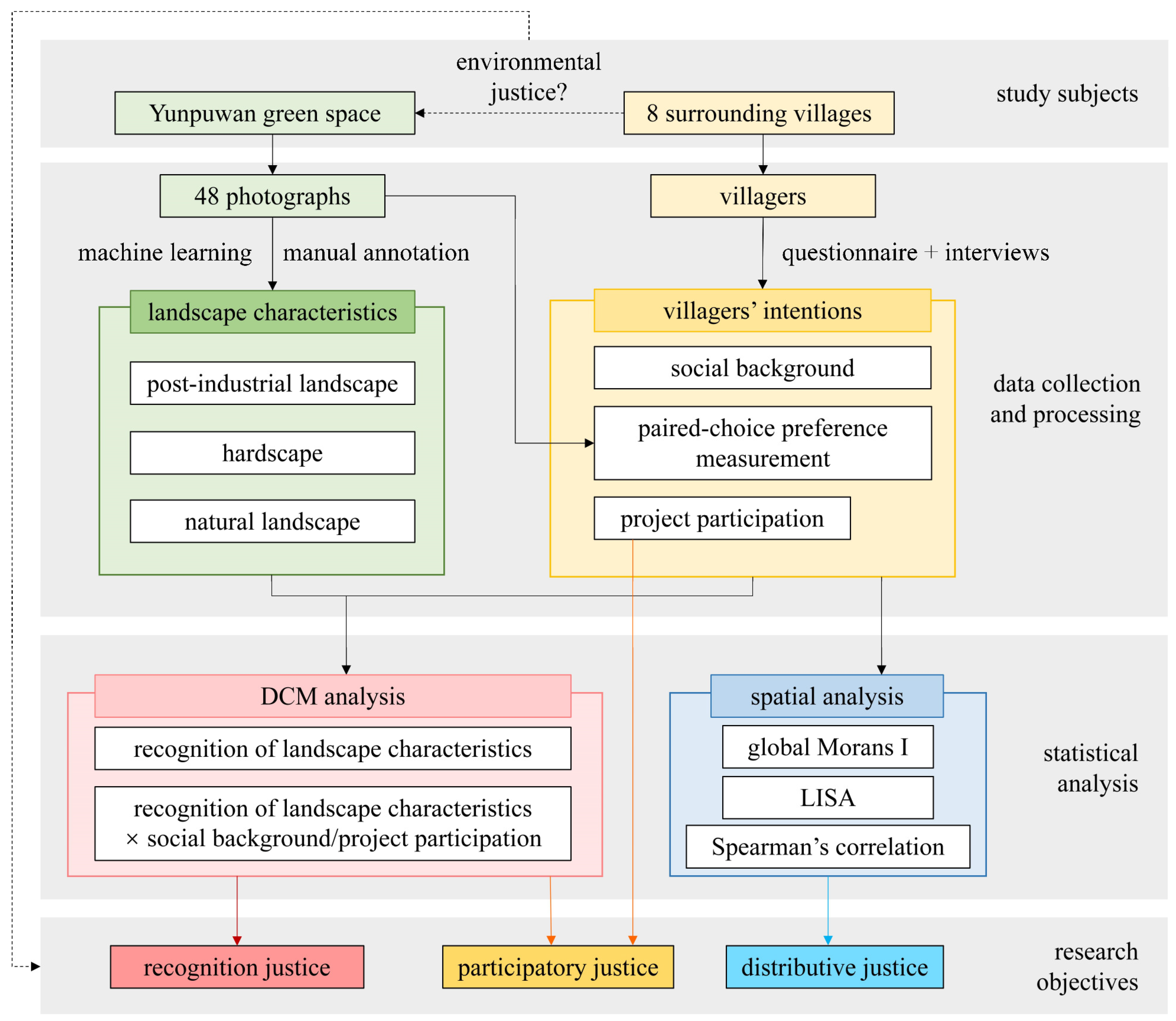
The research framework of this study is illustrated in Figure 2. The study first collected and screened 48 photographs of the study green space and quantified landscape characteristics in each image through a combination of machine learning and manual annotation. Subsequently, a survey was conducted with villagers from eight settlements surrounding the site, encompassing socio-demographic information, a pairwise preference elicitation task, and a semi-structured interview. Based on the discrete choice modeling framework, villagers’ recognition of the post-industrial landscape was evaluated. The interaction effects between villagers’ socio-demographic attributes and their pairwise choices were further analyzed to explore the relationships among social background, project participation, and recognition. These quantified relationships were then linked to landscape characteristics to reveal how post-industrial landscapes relate to villagers’ perceptions of environmental justice. In addition, recognition scores were spatially mapped, and indices such as spatial autocorrelation were calculated using ArcGIS to examine the spatial distribution of landscapes recognized by villagers and to assess their association with villagers’ overall evaluations. Collectively, these research pathways aim to investigate the three dimensions of environmental justice—distributive justice, participatory justice, and recognition justice (definitions and measurement methods are summarized in Table 1)—and to establish linkages with planning, design, and management practices in landscape architecture.

2.2. Photograph Collection and Quantification of Landscape Characteristics

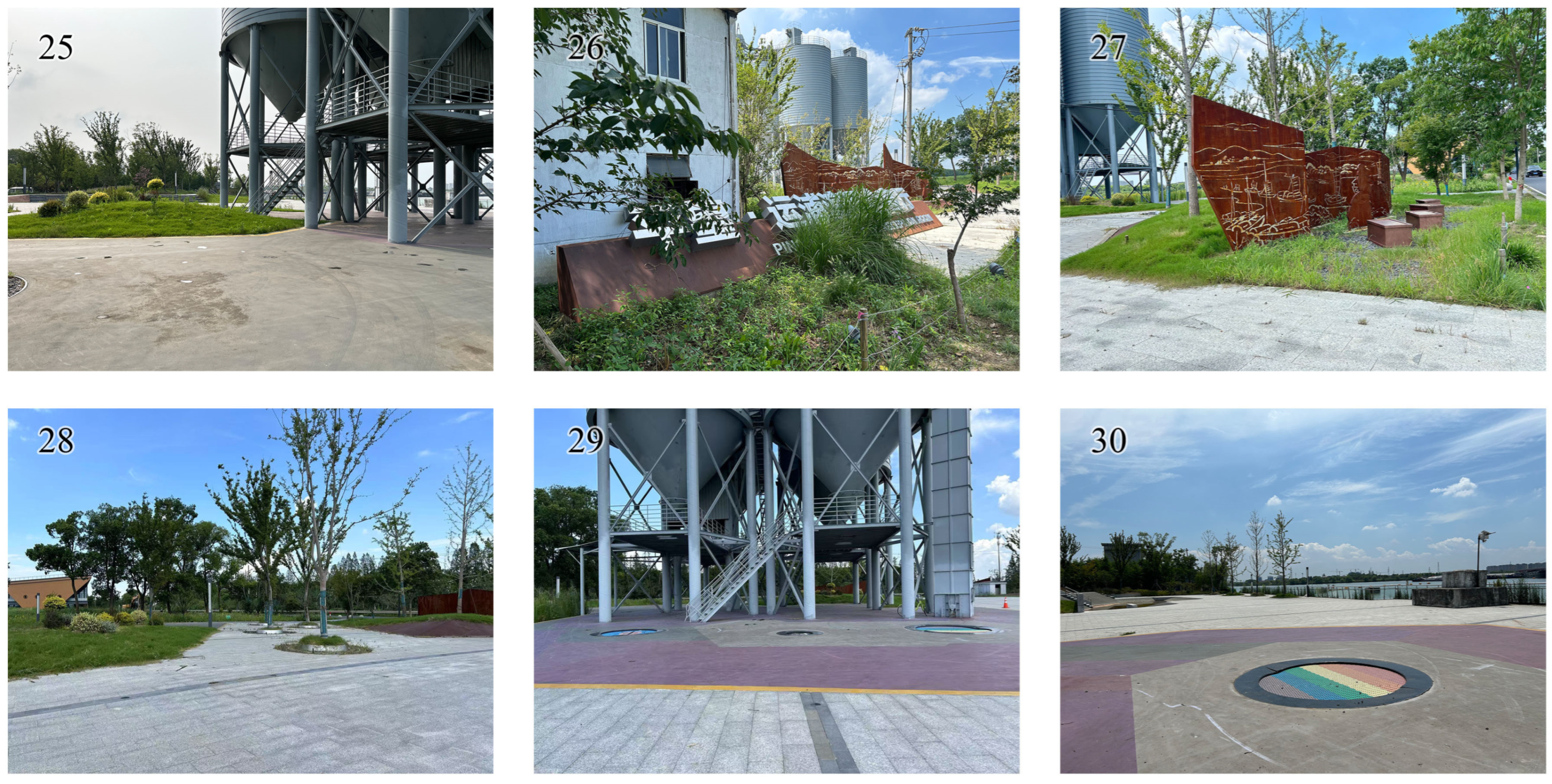
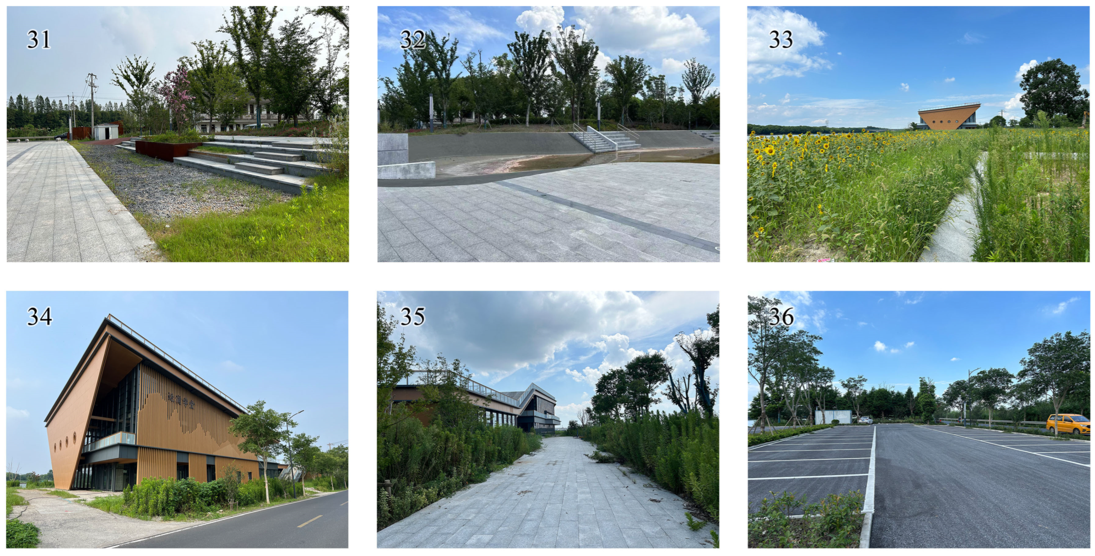
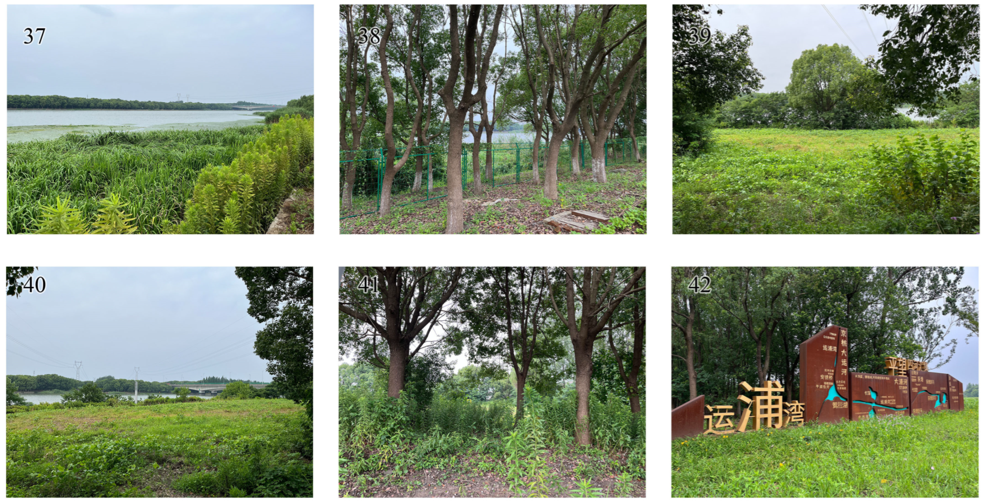
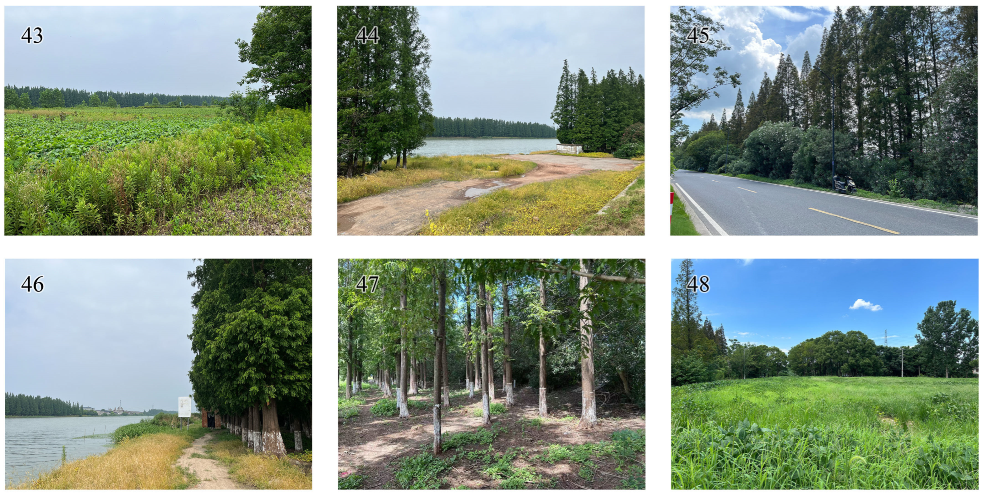
In this study, a large number of photographic samples were collected and subsequently screened to identify representative landscape images [42]. A total of 882 photographs of the study site were captured, from which 48 representative images were selected.
To illustrate this selection process in the main text, nine representative images are presented in Figure 3. The full set of 48 selected photographs is provided in Appendix A. All photographs were taken using a GPS-enabled camera at a resolution of 4032 × 3024 pixels. During image capture, the horizon was positioned between one-third and one-half of the frame to ensure consistent composition. Photographs were taken between 07:00 and 11:00 in July 2025 under clear weather conditions. The selection of representative photographs followed three main criteria: (1) the ability to represent all landscape types and elements present at the site; (2) the absence of irrelevant characteristics, such as litter, that could affect respondents’ perception; (3) relatively consistent lighting conditions, avoiding backlighting or direct sunlight. The GPS locations of the 48 selected photographs are indicated in Figure 3. The GPS locations of the nine images shown in Figure 3 are indicated, while the full set of 48 representative photographs can be found in Appendix A.
Subsequently, landscape characteristics were quantified for the 48 selected photographs (Table 1). The indicators employed have been widely used in studies of linear waterfront, rural, and post-industrial landscapes [1,50,51,52]. Quantification was carried out using a combination of machine learning and manual annotation. Machine learning was primarily applied for image segmentation and for calculating the proportion of landscape elements within each photograph. Specifically, SegFormer-B5, pre-trained on ADE20K (SceneParse150), was used as the base semantic segmentation model. Analyses were conducted using Python v3.11, with PyTorch v2.1.0 and HuggingFace v2.1.0 Transformers as the core libraries. To prevent out-of-memory errors from the high-resolution images, a memory-efficient inference strategy was implemented. Following automatic classification with the pre-trained model, results for all 48 photographs were manually verified and corrected, and the landscape characteristics were computed. For certain functional attributes of landscape, manual annotation (presence/absence) was employed to ensure feasibility. For indicators such as vegetation naturalness, five doctoral researchers in landscape architecture independently scored each photograph, and the average values were used.

2.3. Questionnaire Survey and Semi-Structured Interviews

Villagers’ perspectives on the project were collected through a questionnaire survey complemented by semi-structured interviews (see Table 2 for the questionnaire and interview guide). The survey consisted of four parts:
(1)
Socio-demographic background (Q1–Q4). Basic information regarding villagers’ social and demographic characteristics was recorded.
(2)
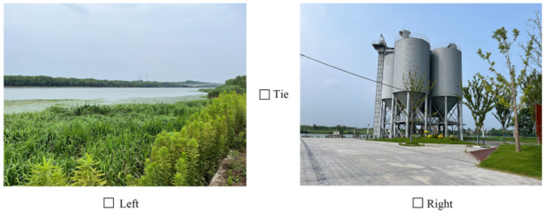
Paired comparison preference elicitation (Q6–Q16). Each respondent was presented with 10 randomly generated pairs of photographs drawn from the set of 48 images. For each pair, villagers were asked to select the photograph they “recognized” more strongly—that is, the one they considered more appropriate for local use and more personally preferable. The photographs were displayed electronically on an iPad by the interviewer, and respondents made their choices directly. The questionnaire was implemented using the Wenjuanxing platform, which ensured equal probabilities for all images to be sampled. Random sampling of pairs, rather than exhausting all possible comparisons, was adopted to mitigate respondent fatigue and attentional decline. Pre-survey tests indicated that 10 pairs represented an optimal balance between robustness and respondent tolerance.
(3)
Project participation (Q17–Q21). This section examined villagers’ involvement in the project, with Q20 and Q21 designed as open-ended interview questions.
(4)
Overall project evaluation. Finally, respondents were asked to provide an overall evaluation of the project, indicating whether, from their perspective, the project was acceptable and recognized as beneficial for the community (Table 3).

2.4. Discrete Choice Modeling Framework

This study employed pairwise comparisons to elicit preferences, and statistical modeling was conducted within a discrete choice modeling framework [36,42].
To match the attribute differences in the paired comparisons, all photograph-level characteristics were constructed as left–right difference variables:
d f = x f , L x f , R
where x f , L and x f , R denote the values of characteristic f in the left and right images of a given pair, respectively. To enhance comparability and numerical stability, all predictors—including differences and interaction terms—were standardized within the sample using z-scores (mean = 0, standard deviation = 1). Consequently, the coefficients can be interpreted as the marginal effect on choice propensity associated with a one standard deviation increase in the difference.
To capture heterogeneity among respondents, interaction terms were constructed between selected numerical respondent variables R r and key differences d f :
d f × R r
Here, R r was coded as numeric and standardized using the same z-score procedure as the difference variables.
The three possible outcomes of each pairwise comparison were coded as follows: choose right y = 0, tie y = 1, choose left y = 2. An ordered probit model was then specified. Let the latent utility difference Δ U be:
      Δ U = f β f d f main   effects + f , r γ f r d f × R r respondent   interactions
To account for ties, two thresholds τ 1 < τ 2 were introduced to categorize Δ U into three outcomes:
                                                                                  y = 0 ,         Δ   U < τ 1   ( C h o o s e   R ) 1 ,         τ 1 Δ   U τ 2 ( T i e ) 2 ,         Δ   U > τ 2   ( C h o o s e   L )
In terms of interpretation, β f > 0 indicates that a higher value of characteristic f in the left image increases the likelihood of choosing the left image, whereas γ f r > 0 implies that the effect of d f is strengthened as the respondent variable increases. Since R r has been centered, β f can be understood as the main effect for the “average respondent.”
For descriptive purposes, a victory rate v was also reported for each photograph (win = 1, loss = 0, tie = 0.5), providing an intuitive reference, although it does not replace formal model inference.

2.5. Spatial Analysis

The spatial equity of popular landscapes across the study site was assessed using both global [53] and local spatial autocorrelation metrics [54]. The victory rate v of each photograph served as the primary indicator for evaluating the spatial distribution of favored landscapes. To account for the uneven spatial density of photograph sampling points, a kernel density analysis was conducted first. Regression modeling using ordinary least squares (OLS) was then performed to obtain standardized residuals, from which a spatial weights matrix was constructed. Spatial autocorrelation patterns were subsequently analyzed based on these residuals, mitigating potential biases from unequal sampling densities.
In addition, Empirical Bayesian Kriging (EBK) was applied to interpolate and map photograph scores across the study area [54], providing a continuous representation of landscape recognition patterns.
To further investigate the relationship between spatial distribution and villagers’ perceived environmental justice, correlations were analyzed between respondents’ residential villages and the spatial locations of the 48 landscape sample points. Specifically, an 800 m buffer was established around each village, and the mean victory rate v of photograph samples within this buffer was calculated and assigned to each resident, yielding an indicator v d . This indicator reflects the average recognition of landscapes surrounding the respondents’ residences. Finally, the association between v d and the overall recognition rating from Q22 of the questionnaire was assessed using Spearman’s rank correlation to determine whether a statistically significant relationship exists.

3. Results

3.1. Questionnaire Response and Descriptive Statistics

A total of 103 questionnaires were distributed, and 98 valid responses were obtained, yielding an overall response rate of 95.1%. Five questionnaires were excluded due to communication difficulties encountered with elderly participants during field interviews, where strong local dialects hindered accurate information collection. All valid respondents were confirmed as residents of the nine villages within the study area. The socio-demographic characteristics of the surveyed villagers are summarized in Table 4.
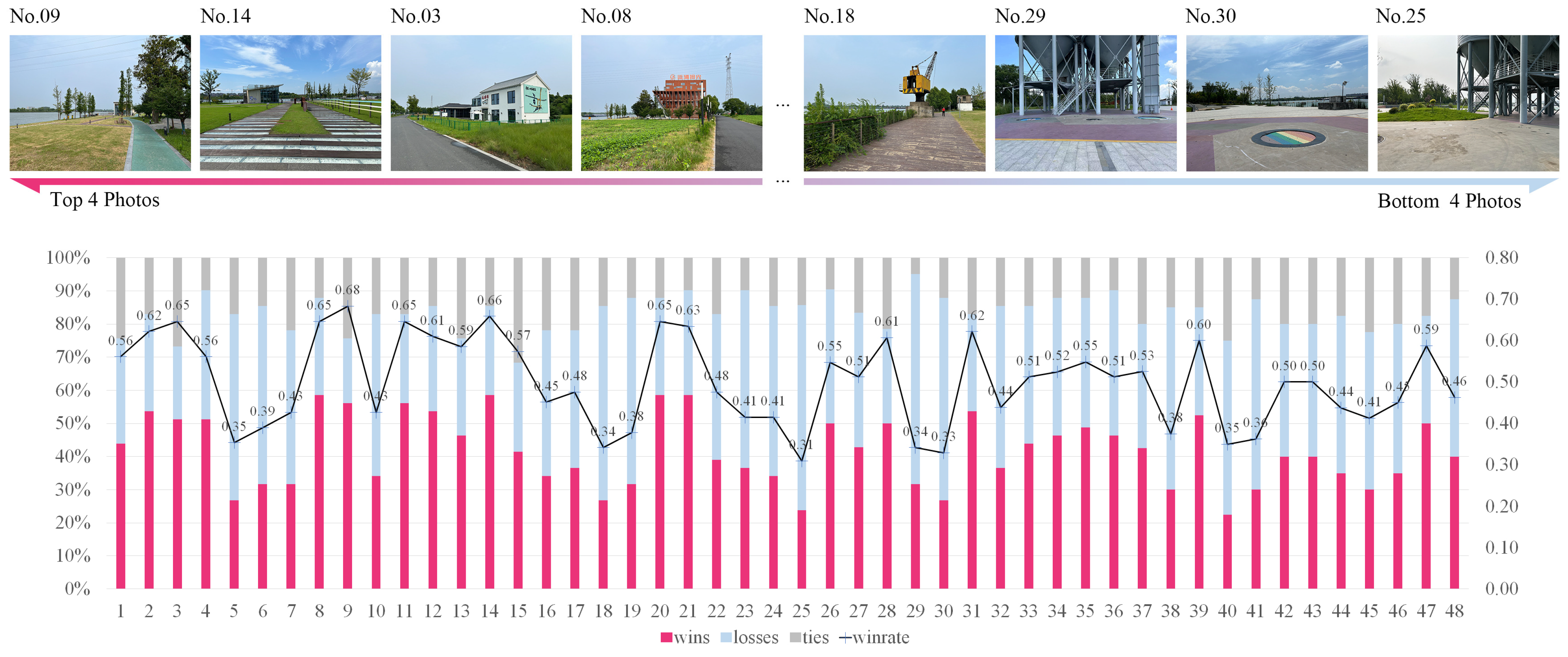
Victory rate rankings for all photographs are provided in Appendix A, and Figure 4 highlights the four highest- and lowest-scoring images. The highest-scoring scene (ID = 09) depicts a linear waterfront herbaceous area, with a pedestrian path running along one side of the grassland and a service building visible in the distance. The lowest-scoring scene (ID = 25) presents a close-up of an industrial heritage, showing an activity plaza and adjacent green space beside the heritage.

3.2. Discrete Choice Analysis

Table 5 presents the statistically significant landscape characteristics in the model without interaction terms. The results indicate that landscapes with more naturalized vegetation (β = −0.17, p = 0.004), higher proportions of plazas (β = −0.36, p = 0.005), higher proportions of industrial heritage (β = −0.19, p = 0.008), and higher proportions of pedestrian paths (β = −0.20, p = 0.03) were less likely to be selected by respondents. In contrast, landscapes with larger proportions of total hardscape (β = 0.94, p = 0.045) were more likely to be chosen.
When interaction terms were included, the statistically significant characteristics are summarized in Table 6. The results indicate that:
(1)
The interaction between industrial-memory landscape and gender was significant (γ = 0.46, p = 0.018), indicating that male respondents were more likely to select photographs with a higher proportion of heritage landscape.
(2)
The interaction between industrial heritage and work history was significant (γ = 0.24, p = 0.020), showing that villagers who had previously worked in the original factories were more likely to select photographs with higher proportions of industrial heritage.
(3)
The interaction between water bodies (%) and years of residence in the village was significant (γ = 0.42, p = 0.028), suggesting that villagers who had lived longer in the village were more likely to select photographs with higher proportions of water characteristics.
(4)
The interaction between total hardscape (%) and years of residence in the village was significant (γ = 3.37, p = 0.035), indicating that long-term residents were more likely to select photographs with higher proportions of hardscape.
(5)
The interaction between waterfront access and project awareness was significant (γ = 0.31, p = 0.036), implying that villagers familiar with the project were more likely to select photographs offering greater accessibility to water.
(6)
The interaction between sky openness (%) and years of residence in the village was significant (γ = 2.39, p = 0.049), suggesting that villagers with longer residence were more likely to select photographs depicting more open sky views.
Among these interactions, the effect of industrial heritage reversed in sign compared with the non-interaction model, whereas the effect of hardscape (%) remained consistent with the non-interaction model.

3.3. Participation-Related Interviews

Among the 98 valid questionnaires, only one respondent indicated that they had participated in the decision-making consultation process, noting that their involvement was “mainly related to land acquisition, and no effective feedback was provided.” A total of 31 respondents (31.63%) reported that they were entirely unaware of the project, and 38 respondents (38.78%) stated that they had never engaged in recreational activities within the project site. In addition, 19 respondents provided suggestions for improvement. These suggestions were classified and summarized into four major categories (Table 7): (1) optimization of landscape design, (2) enhancement of community-oriented facilities, (3) livelihood and industrial development, and (4) project implementation.

3.4. Spatial Patterns of Landscape Recognition and Equity

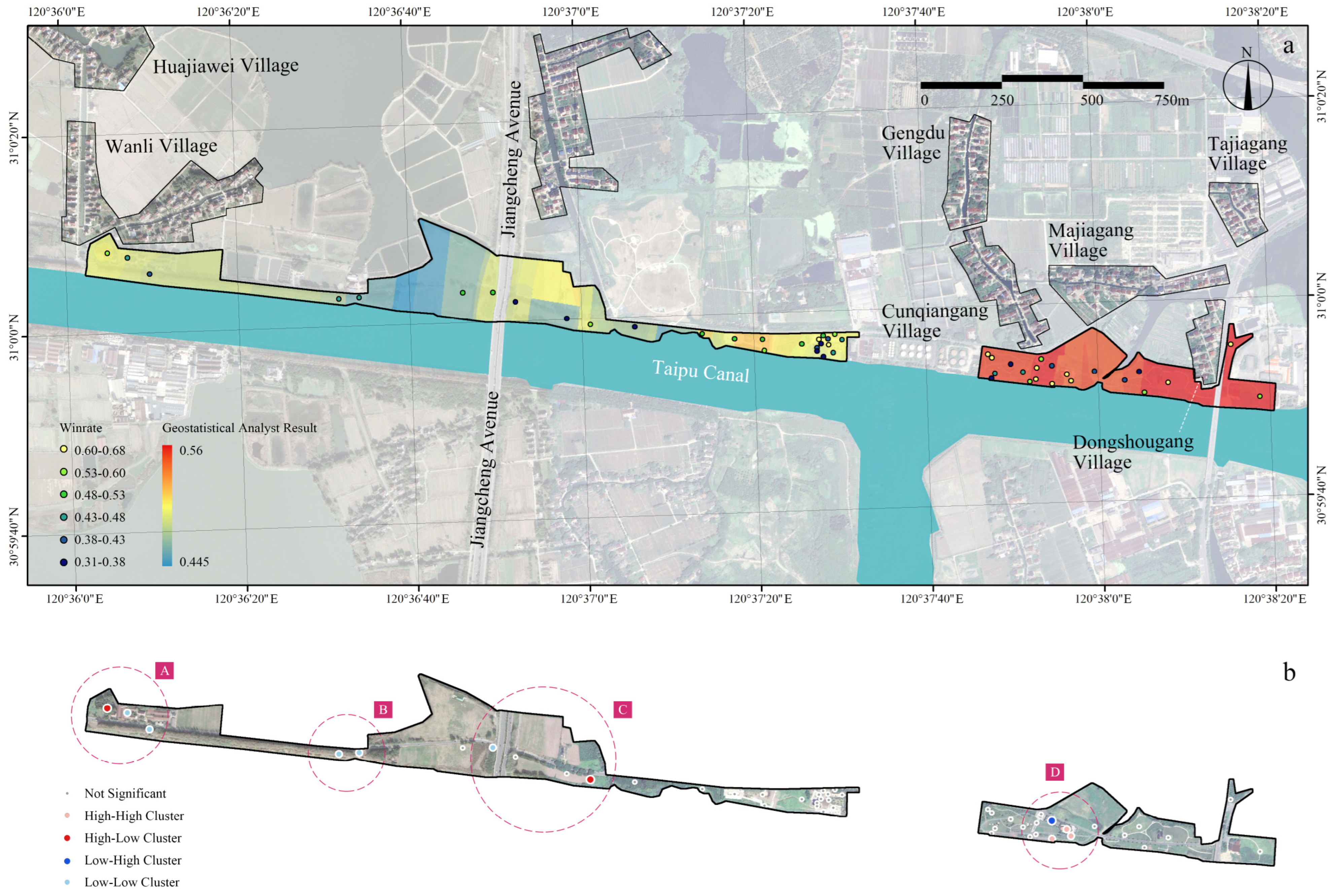
Global spatial autocorrelation revealed no significant clustering trend (Moran’s I = 0.089; z = 1.856; p = 0.063). However, local spatial autocorrelation (LISA) identified two significant high–low clusters and one high–high cluster (Figure 5b), located in the southern green space of Wanli Village (A), along both sides of Jiangcheng Avenue (B and C), and in the southern green space of Cunqiangang Village (D). Overall, the distribution of preferred landscapes does not indicate systematic spatial injustice, yet several “pockets of unfairness” were observed locally. Furthermore, the results of spatial interpolation (Figure 5a) suggest that landscapes in the eastern portion of the study area tend to be more favored by residents, whereas those in the western portion, particularly around Jiangcheng Avenue, exhibit notably lower preference levels.
The Spearman correlation analysis between V d and the overall recognition score yielded a significant result ( ρ = 0.382, p < 0.05), indicating that villagers residing closer to landscapes with higher recognition levels tended to express greater overall recognition of the project.

4. Discussion

4.1. Recognition Justice in Rural Post-Industrial Landscapes

The results of the pairwise comparison survey revealed clear associations between key landscape characteristics and villagers’ recognition. Industrial heritage and related landscape characteristics, as core elements of post-industrial landscapes, were found to have particularly strong links with villagers. Industrial heritage, in general, was not recognized by villagers, a finding that appears to contradict existing studies highlighting the heritage value of such characteristics in urban contexts [5]. However, the discrete choice model results indicate a significant negative effect of industrial heritage (β = −0.1935, p = 0.0082), confirming the limited recognition among the general population. In the interaction term, we found the opposite pattern among villagers with industrial work experience (industrial heritage × work history, γ = 0.2383, p = 0.0198), suggesting that for them, the value of heritage lies primarily in the memories and emotional connections it evokes. With respect to industrial-memory landscapes, male villagers displayed a significantly stronger preference (industrial-memory landscape × gender, γ = 0.4553, p = 0.0183), likely reflecting their predominant role in industrial production and the associated memories and perspectives [55]. Such gender-based perceptual differences are often overlooked in the protection of industrial heritage, potentially leading to inequalities in recognition justice.
Among the natural landscape indicators, vegetation naturalness exhibited a strong association with villagers’ perceptual preferences (β = −0.1761, p = 0.0040). Respondents tended to recognize more urbanized landscapes—those characterized by intensive maintenance and artificiality—a pattern that appears consistent across both urban and rural settings [56]. Contemporary design approaches emphasizing biodiversity and rewilding have become a prevailing trend in landscape architecture [57,58]. However, such strategies may exacerbate perceptions of environmental injustice among local villagers, underscoring the need for designers to carefully balance biodiversity objectives with preferences for more artificial landscapes. In the interaction effects, water bodies and waterfront access demonstrated pronounced associations with perceptions in specific villager groups (water bodies × years of residence, γ = 0.4203, p = 0.0279; waterfront access × project awareness, γ = 0.3108, p = 0.0364). water bodies and waterfront access demonstrated pronounced associations with perceptions in specific villager groups. Water characteristics had a stronger positive influence on long-term residents (sky openness × years of residence, γ = 2.3943, p = 0.0493), likely because water represents a culturally salient element that embodies local identity and collective memory [59]. Similarly, waterfront access had a more favorable effect among respondents who were aware of the project, suggesting that knowledge of the initiative may shape recognition of evolving human–water relationships and foster positive attitudes toward them. In addition, expansive scenes (sky openness) were preferred by long-term residents, possibly because such open plain landscapes align more closely with their lived environmental experiences and enduring landscape imaginaries.
The composite indicator of total hardscape—which encompasses pedestrian paths, service-related paving, and bases of directly used facilities—appears to be more closely associated with perceived usability (β = 0.9415, p = 0.0454). In contrast, the proportion of plazas emphasizes expanses of open paving; when lacking shade, activity infrastructure, or proximate services, these spaces are often perceived as empty and offering limited opportunities for engagement (plazas, β = −0.3613, p = 0.0049). The coexistence of these opposing effects is not contradictory; rather, it highlights that multifunctional and content-rich design refinement is critical to enhancing recognition [60]. Moreover, both descriptive statistics and DCM inferences converge: high-performing photographs commonly exhibit a combination of walkability, places to pause, and visual interest, rather than a mere accumulation of single landscape elements.
Collectively, these findings indicate that recognition in rural contexts is not an abstract value judgment but is tightly interwoven with identity- and experience-based variables such as labor histories, gender roles, duration of residence, and the depth of local knowledge. For designers, the value of industrial heritage does not derive from maximizing the quantity preserved; rather, its recognizability depends on the simultaneous activation of local memory and contemporary use. This suggests that heritage authenticity should be translated into usable memory experiences, for example, through interactive facilities, lightweight exhibitions, or oral history nodes organized around factory trades and processes [61,62], rather than relying solely on accumulations of close-up ruins.

4.2. Participatory Justice in Rural Post-Industrial Landscapes

In the Yunpuwan project, villagers’ participation was limited. This may be attributed to the implementation process, which lacked systematic solicitation and response to local residents’ needs—a critical area for improvement in the execution of future rural landscape projects. The marginalization of villagers’ agency is a common issue in many rural landscape initiatives in China [63]. Although direct participation was limited, questionnaire responses indicate that villagers actively expressed preferences for functional and amenity-rich landscapes, explicitly calling for “add more green amenities and some exercise facilities” and remarking that the site feels “not interesting and lacks vitality”, aligning with semi-structured interview comments. In the present case, there was a misalignment between villagers’ demands and the perceived value of post-industrial landscapes; certain characteristics considered to possess heritage or memory value were regarded by villagers as impractical or outdated. Interview results indicate that residents preferred the development of functional and diverse spaces with additional facilities, a finding consistent with studies of urban post-industrial landscapes [64]. Moreover, the issue of unemployment resulting from post-industrial landscape transformation warrants further consideration in the rural context. Some villagers expressed a desire for more proactive land-use development, including commercial and cultural functions, as well as enhanced promotion. While such interventions may compromise the rustic character of the village, they could also create new employment opportunities. The coexistence of rural gentrification and local economic aspirations, as observed in this Chinese context, has been highlighted in previous research [13].
Beyond direct participation in decision-making, villagers’ connections with the land can indirectly reflect their engagement in the project [65,66]. However, within the interaction effects of the discrete choice model, measures of villagers’ familiarity with or use of the project did not exhibit significant associations with recognition of the landscape. Instead, villagers’ relationships with the project were primarily mediated through historical and cultural ties to the land itself. In this context, both the length of residence in the village and prior employment in the factory demonstrated significant effects in the interaction analysis. These findings suggest that connections between villagers and the land positively influence landscape recognition. In cases where early participation prior to project implementation is limited, initiatives such as enhanced informational campaigns, community events, or the provision of interpretive signage and heritage narrative facilities can strengthen villagers’ ties to the land [67,68], thereby enhancing overall recognition of the project.

4.3. Distributive Justice in Rural Post-Industrial Landscapes

The analysis revealed a significant positive moderating effect of distributive justice on villagers’ overall perception of environmental justice. This finding underscores the importance of distributive justice in rural landscape projects, particularly in linear green spaces. Given that canals represent a common configuration for concentrated rural industrial land-use, such effects should be carefully considered in the planning and design of post-industrial waterfront landscapes.
Global spatial autocorrelation did not reveal significant clustering patterns, whereas local indicators of spatial association (LISA) detected several spatial units exhibiting locally inequitable distribution. For linear green spaces, optimizing distributive justice does not entail uniform distribution; rather, it requires identifying limiting factors in underperforming segments and the spillover conditions from adjacent high-performing nodes [69]. In the present study, four spatial units exhibiting locally inequitable distribution were observed within the rural post-industrial landscape. Three of these pockets were located within semi-naturalized green spaces (A, B, C), predominantly exhibiting low–low and high–low clustering patterns. One pocket was situated within a park (D), displaying high–high and low–high clustering. These patterns suggest that park-based development may generally be more positively perceived by villagers compared to semi-naturalized green spaces, as interviewees described the latter as “not interesting” or “nothing there,” reflecting a preference for more functional and amenity-rich landscapes. Nevertheless, not all parks exhibited clustering effects; for instance, the mid-section park showed no significant aggregation. The park at location D performed better overall, potentially due to its greater diversity of functions, the presence of memory-associated heritage landscapes (rather than mere preservation of industrial relics), and more controlled vegetation design, characterized by extensive open woodland and managed grasslands.
Spatial interpolation results indicate that villagers’ recognition of landscapes is markedly higher in the eastern portion of the site compared to the western portion. This pattern may be related to park development strategies: the eastern area is closer to a tourism-oriented historic town (Pingwang Town), prompting greater governmental investment, whereas the western area has been managed with a focus on ecological and natural values. Although such an approach aligns with the objectives of tourism development [70], it likely reinforces disparities in villagers’ perception of environmental justice [71]. In future phased developments, enhancing multifunctional landscape interventions in low-value areas within the identified “unjust pockets” could help mitigate these spatial inequities.

4.4. Limitations

This study has several limitations. First, due to the fact that nearly all villagers had limited involvement in the decision-making process, the investigation of participatory justice is constrained. This limitation likely reflects a common characteristic of rural landscape projects in China and represents a broader challenge in Chinese rural landscape research [72]. Second, the study employed photo-based pairwise comparisons to assess villagers’ preferences, which are strongly influenced by visual and aesthetic cues and may overlook other sensory perceptions, including auditory, olfactory, and climatic factors. This limitation is particularly relevant for villagers who have not previously used the site, as photo-based evaluations may lead to misperceptions of the site and misjudgments regarding its functional characteristics. In addition, the method does not account for temporal or seasonal variations, such as aesthetic changes associated with plant phenology. Third, the study primarily focuses on villagers’ attitudes toward rural landscapes. The findings suggest that villagers’ understanding of environmental justice may differ substantially from that of experts, tourists, or policymakers, indicating the need for future comparative studies to explore these differing perspectives.

5. Conclusions

The study examined the relationships between rural post-industrial waterfront green spaces and villagers’ environmental justice across three dimensions: recognition justice, participatory justice, and distributive justice.
In terms of recognition justice, villagers generally did not favor the direct preservation of industrial heritage; however, for those with prior work experience in factories, the value of industrial heritage as part of the landscape was more readily acknowledged. Villagers showed greater preference for anthropogenic vegetation, small-scale plazas and pedestrian paths, as well as higher proportions of hardscape. Notably, male respondents exhibited stronger recognition for landscapes incorporating industrial-memory elements, while long-term residents expressed greater appreciation for water bodies, hardscape, and expansive spatial configurations along the canal. Additionally, waterfront accessibility was positively perceived by villagers who were familiar with the project. Overall, we suggest that multifunctional and accessible landscapes that actively integrate industrial heritage are more likely to be recognized by villagers. In related project designs, attention should be given to investigating and considering villagers’ gender composition, residential history, and work experience.
In terms of participatory justice, villagers’ involvement in the project was very limited, revealing potential shortcomings in public engagement and project management. Interviews indicated a mismatch between the existing landscape characteristics and villagers’ needs for functional and practical spaces. Furthermore, the transformation of industrial land raised livelihood concerns, as issues such as unemployment prompted villagers to consider the project’s capacity to support economic activity and employment opportunities. The study did not find a significant effect of villagers’ connections with the project on their recognition of it; however, connections between the land itself and the villagers were found to influence their evaluations.
Regarding distributive justice, the study identified a positive moderating effect of equitable spatial distribution on villagers’ overall perception of environmental justice. In addition, several locally inequitable areas were detected within the project site, suggesting that the development patterns of post-industrial landscapes may contribute to spatial inequities. Such inequities may be reinforced by other development objectives, including tourism, which can exacerbate the imbalance in villagers’ access to and recognition of the landscape.
These findings highlight localized patterns of inequity while demonstrating the broader applicability of the methodological framework employed. By integrating recognition, participatory, and distributive dimensions of environmental justice with landscape assessment and villagers’ perspectives, the framework provides a robust basis for analyzing rural post-industrial contexts in China, particularly in the Jiangnan region and other canal-related areas. Despite these insights, several limitations warrant consideration. Villagers’ limited involvement in decision-making constrains the assessment of participatory justice, reflecting a common challenge in Chinese rural landscape research. Reliance on photo-based pairwise comparisons emphasizes visual aesthetics but overlooks other sensory and temporal dimensions, suggesting the need for sustained observation and multi-sensory evaluation in future research. Moreover, focusing primarily on villagers’ attitudes may obscure divergent perspectives of experts, tourists, and policymakers. Future research should address these gaps through comparative, longitudinal, and multi-sensory studies, alongside participatory design and community co-management approaches, to capture evolving experiences and promote more equitable landscape outcomes.
Overall, the study elucidates the environmental injustices experienced by villagers within rural post-industrial landscapes and highlights the relationships between landscape project characteristics, implementation processes, spatial distribution, and environmental justice. Post-industrial landscape projects in rural contexts should not be guided solely by macro-level ecological or tourism objectives; they must also integrate local considerations of villagers’ needs to achieve sustainable development outcomes.

Author Contributions

Conceptualization, Y.Z., M.G. and L.T.; methodology, Y.Z., L.T. and M.G.; software, M.G.; validation, M.G., L.T. and X.L.; formal analysis, L.T.; investigation, J.W. and H.J.; resources, X.L.; data curation, X.L.; writing—original draft preparation, L.T. and M.G.; writing—review and editing, Y.Z. and M.G.; visualization, M.G.; supervision, Y.Z.; project administration, Y.Z.; funding acquisition, Y.Z. and L.T. All authors have read and agreed to the published version of the manuscript.

Funding

This research was funded by the National Natural Science Foundation of China, grant numbers 52308072 and 52508044.

Institutional Review Board Statement

The study was conducted in accordance with the Declaration of Helsinki, and approved by the Ethics Committee of Soochow University (Approval code: SUDA20251105H06; Approval date: 5 November 2025).

Informed Consent Statement

Informed consent was obtained from all subjects involved in the study.

Data Availability Statement

The raw data supporting the conclusions of this article will be made available by the authors on request.

Acknowledgments

During the preparation of this manuscript/study, the authors used ChatGPT4.0 for the purposes of polishing the translated manuscript. The authors have reviewed and edited the output and take full responsibility for the content of this publication.

Conflicts of Interest

The authors declare no conflicts of interest. The funders had no role in the design of the study; in the collection, analyses, or interpretation of data; in the writing of the manuscript; or in the decision to publish the results.

Appendix A

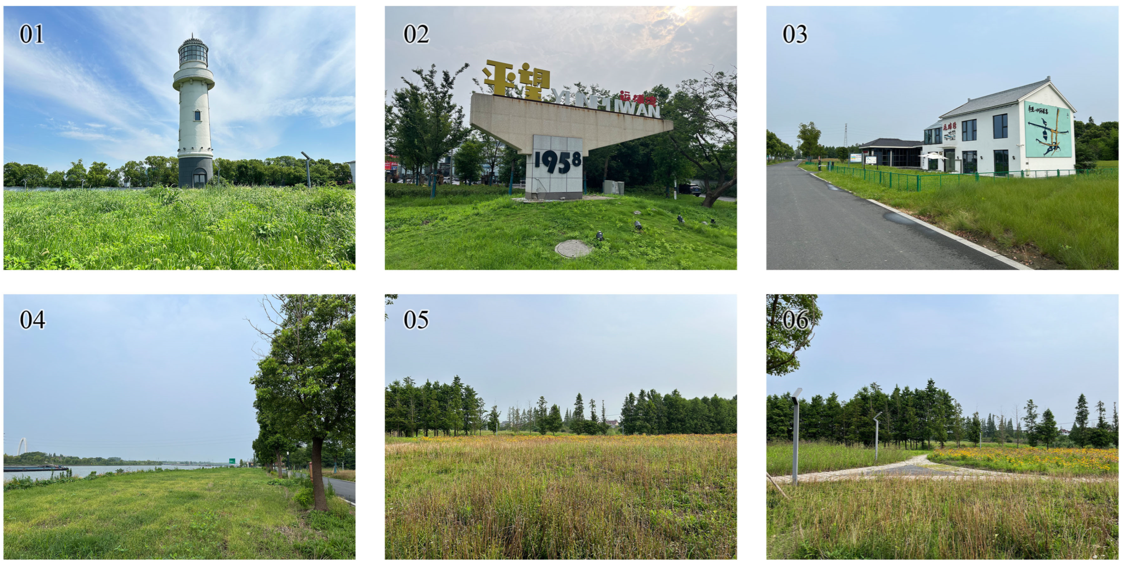
Figure A1. Photographic Documentation of Current Site Conditions (Images 01–06).
Land 14 02204 g0a1
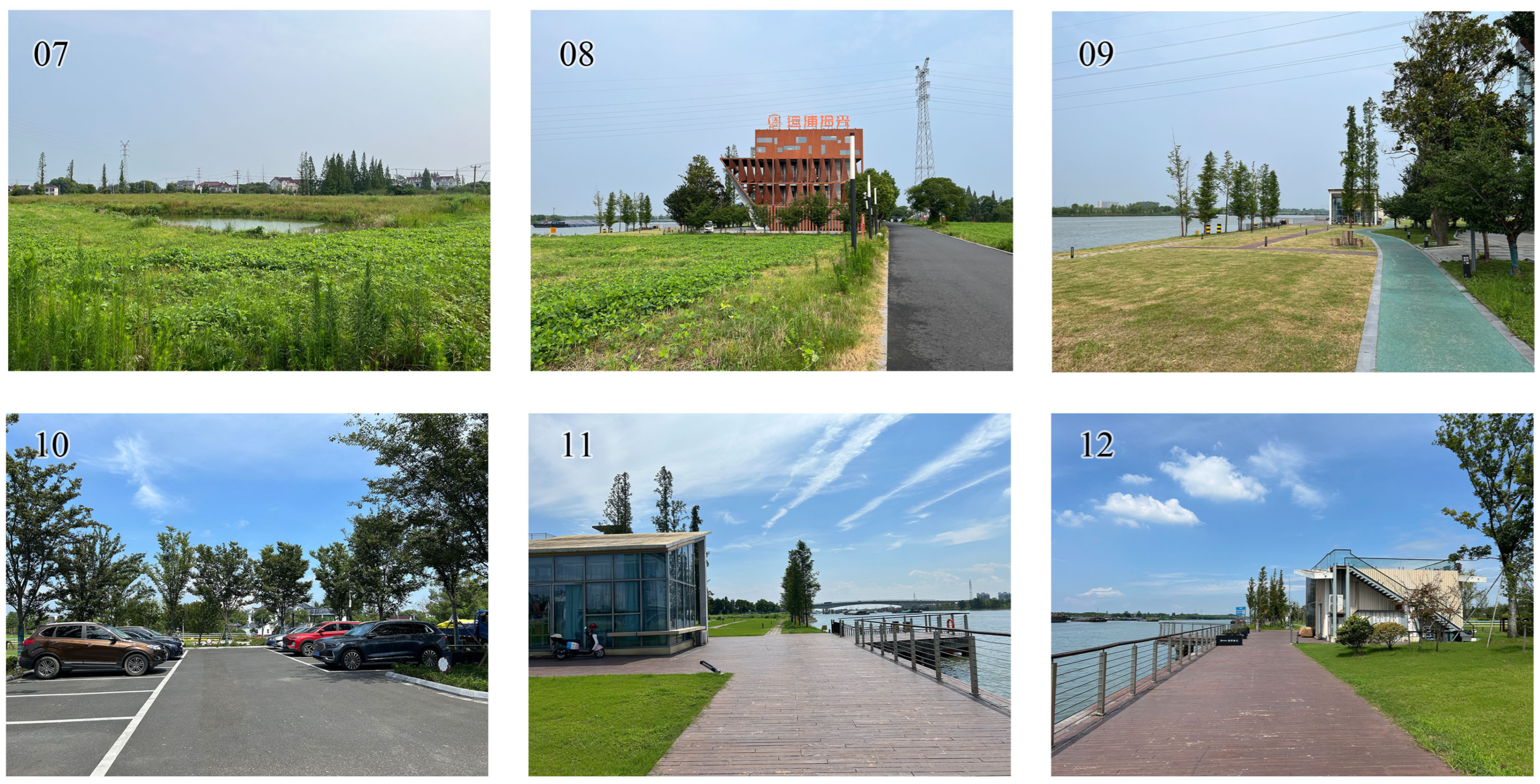
Figure A2. Photographic Documentation of Current Site Conditions (Images 07–12).
Land 14 02204 g0a2
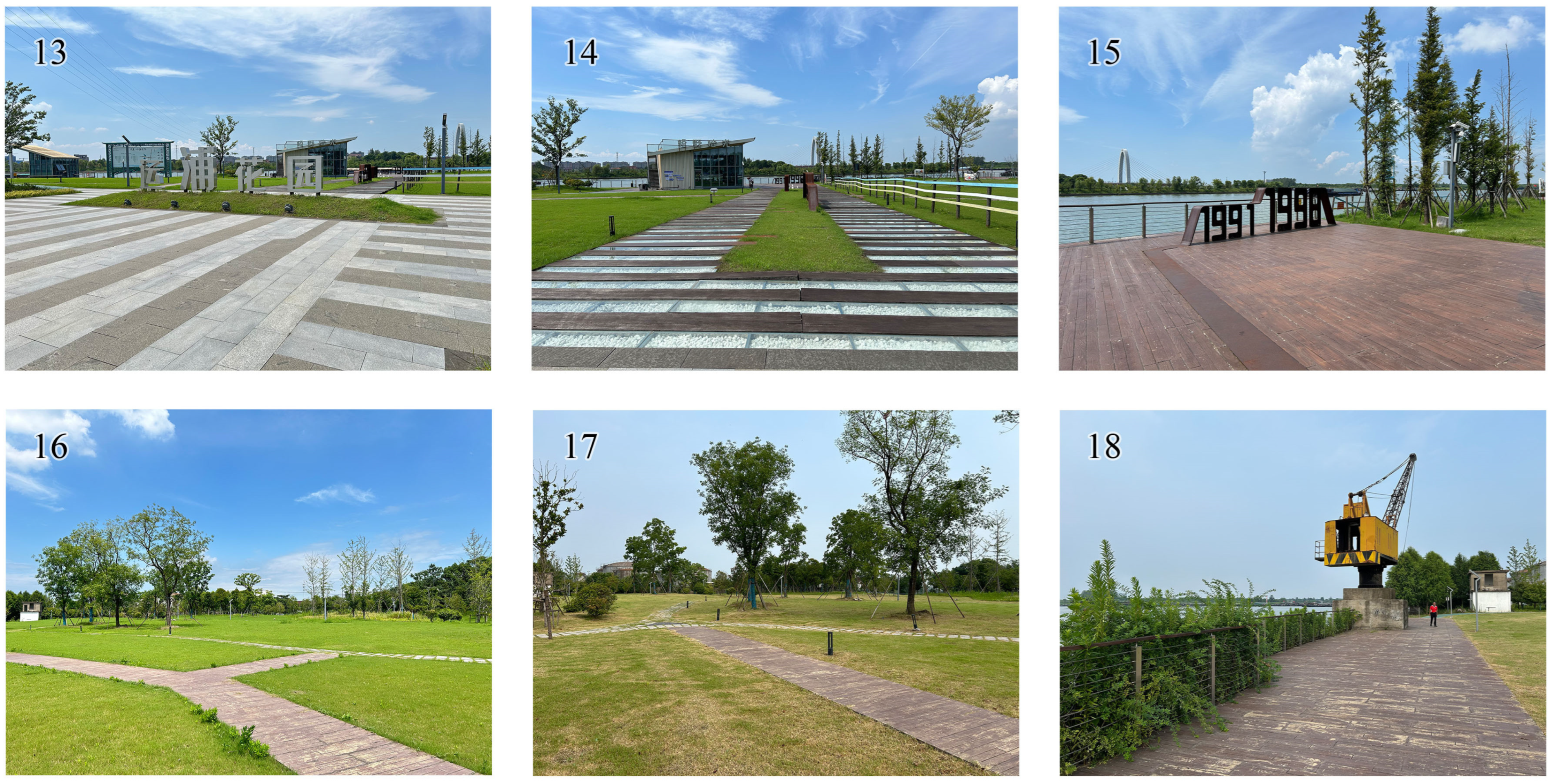
Figure A3. Photographic Documentation of Current Site Conditions (Images 13–18).
Land 14 02204 g0a3
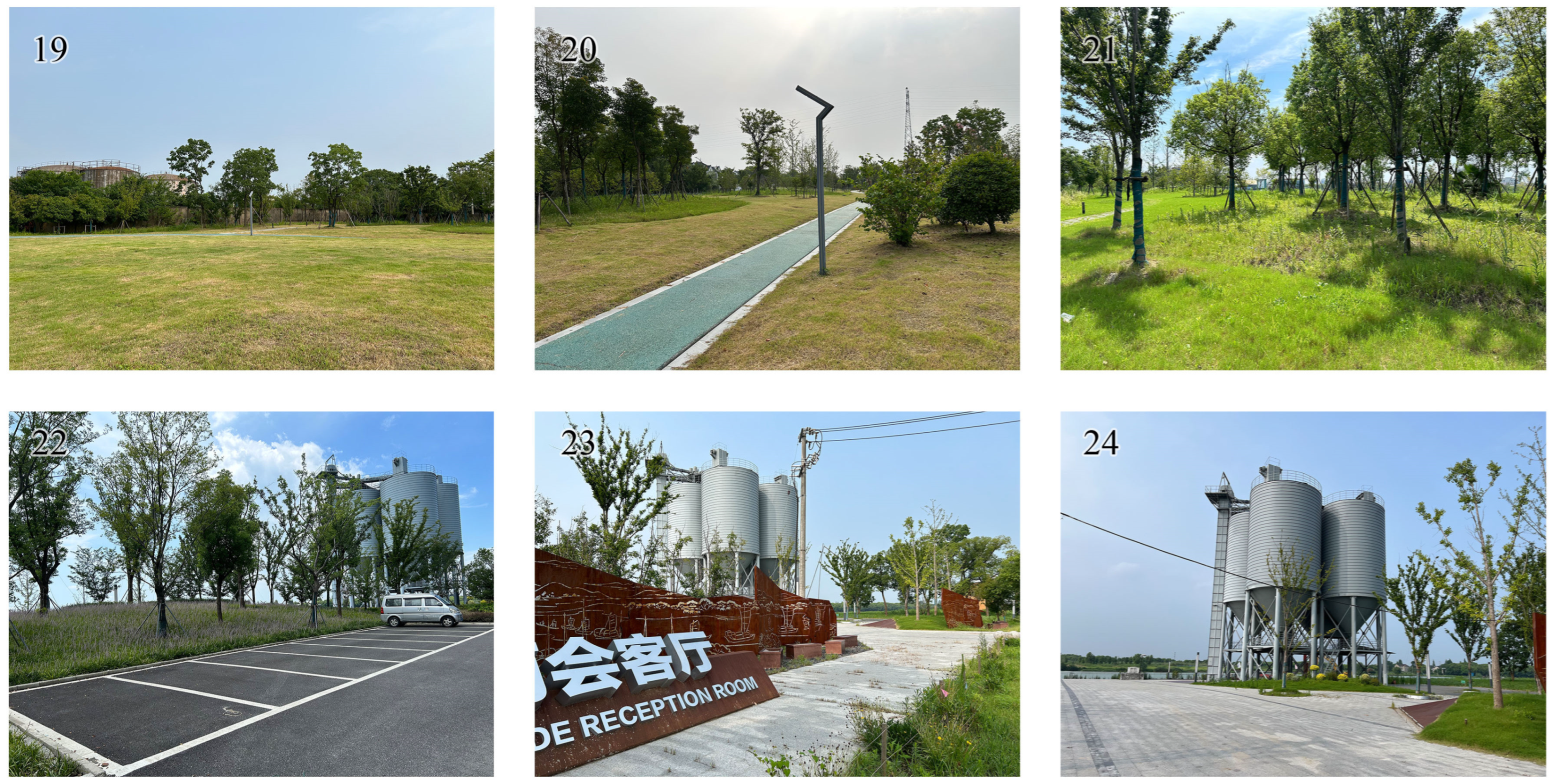
Figure A4. Photographic Documentation of Current Site Conditions (Images 19–24).
Land 14 02204 g0a4
Figure A5. Photographic Documentation of Current Site Conditions (Images 25–30).
Land 14 02204 g0a5
Figure A6. Photographic Documentation of Current Site Conditions (Images 31–36).
Land 14 02204 g0a6
Figure A7. Photographic Documentation of Current Site Conditions (Images 37–42).
Land 14 02204 g0a7
Figure A8. Photographic Documentation of Current Site Conditions (Images 43–48).
Land 14 02204 g0a8
Figure A9. Spatial Distribution of Sampling Points.
Land 14 02204 g0a9

References

  1. Huang, C.; Wei, F.; Qiu, S.; Cao, X.; Chen, L.; Xu, J.; Gao, J.; Lin, Q. Interpreting Regenerated Post-Industrial Lands as Green Spaces: Comparing Public Perceptions of Post-Industrial Landscapes Using Human Factor Design Framework. Ecol. Indic. 2023, 157, 111282. [Google Scholar] [CrossRef]
  2. Ravaz, B.; Bombenger, P.-H.; Capezzali, M.; Meyer, T. Reviewing 20 Years of Redevelopment Trajectories of Industrial Sites Literature and Highlighting New Research Perspectives. Land Use Policy 2024, 146, 107326. [Google Scholar] [CrossRef]
  3. Sun, L.; Fan, X. Research Hotspots and Future Trends in Canal-Related Industrial Buildings. Sustainability 2024, 16, 5208. [Google Scholar] [CrossRef]
  4. Marsh, B. Living by the Symbolic River: Landscape Effects of Post-Industrial Water Narratives of the Susquehanna River. Land 2023, 12, 264. [Google Scholar] [CrossRef]
  5. Huang, C.; Wei, F.; Han, Q.; Xu, J.; Qiu, S.; Ban, X.; Huang, Y.; Huang, T. Visual and Emotional Interaction between People and Post-Industrial Riverscape Based on the Significance of “Original—New Placement. Ecol. Indic. 2024, 163, 112135. [Google Scholar] [CrossRef]
  6. Heesche, J.; Braae, E.M.; Jørgensen, G. Landscape-Based Transformation of Young Industrial Landscapes. Land 2022, 11, 908. [Google Scholar] [CrossRef]
  7. Liu, Z.; Fang, H.; Xu, S.; Wu, Y.; Wen, K.; Shen, Z.; Wang, H. Retain or Remove? Decision-Making of Rural Industrial Park Redevelopment in Nanhai District, China. Front. Environ. Sci. 2024, 12, 1347723. [Google Scholar] [CrossRef]
  8. Suzhou Municipal People’s Government. Advancing the “Three Optimizations and Three Safeguards” to Build Development Momentum: The Chairpersons’ Meeting of the Standing Committee of the Suzhou Municipal People’s Congress Received a Briefing. Available online: https://www.suzhou.gov.cn/szsrmzf/szyw/202108/66b299c3a58d4c77a6e7dccfce63ca2b.shtml (accessed on 13 August 2025).
  9. Ministry of Culture and Tourism. Notice by Seventeen Departments Including the Ministry of Culture and Tourism on Issuing the Guiding Opinions on Promoting the Sustainable Development of Rural Tourism. Available online: https://www.gov.cn/zhengce/zhengceku/2018-12/31/content_5433069.htm?utm_source=chatgpt.com (accessed on 13 August 2025).
  10. Xinhua News Agency. Opinions of the CPC Central Committee and the State Council on Implementing the Rural Revitalization Strategy. Available online: https://www.gov.cn/zhengce/2018-02/04/content_5263807.htm?utm_source=chatgpt.com (accessed on 13 August 2025).
  11. Yanan, L.; Ismail, M.A.; Aminuddin, A. How Has Rural Tourism Influenced the Sustainable Development of Traditional Villages? A Systematic Literature Review. Heliyon 2024, 10, e25627. [Google Scholar] [CrossRef] [PubMed]
  12. Shen, S.; Wang, H.; Quan, Q.; Xu, J. Rurality and Rural Tourism Development in China. Tour. Manag. Perspect. 2019, 30, 98–106. [Google Scholar] [CrossRef]
  13. Chen, P.; Zhang, M.; Wang, Y. Beyond Displacement: The Co-Existence of Newcomers and Local Residents in the Process of Rural Tourism Gentrification in China. J. Sustain. Tour. 2024, 32, 8–26. [Google Scholar] [CrossRef]
  14. Li, S.; Zhang, Y.; Long, H.; Xu, L. Understanding Rural Gentrification in China: Examining the Evolving Concept and Comparative Insights. J. Rural Stud. 2024, 108, 103301. [Google Scholar] [CrossRef]
  15. Yang, X.S.; Xu, H. Producing an Ideal Village: Imagined Rurality, Tourism and Rural Gentrification in China. J. Rural Stud. 2022, 96, 1–10. [Google Scholar] [CrossRef]
  16. Cheng, H.; Rui, Q.; Yu, K.; Li, X.; Liu, J. Exploring the Influencing Paths of Villagers’ Participation in the Creation of Micro-Landscapes: An Integrative Model of Theory of Planned Behavior and Norm Activation Theory. Front. Psychol. 2022, 13, 862109. [Google Scholar] [CrossRef]
  17. Martin, A.; Armijos, M.T.; Coolsaet, B.; Dawson, N.; AS Edwards, G.; Few, R.; Gross-Camp, N.; Rodriguez, I.; Schroeder, H.; GL Tebboth, M. Environmental Justice and Transformations to Sustainability. Environ. Sci. Policy Sustain. Dev. 2020, 62, 19–30. [Google Scholar] [CrossRef]
  18. Newell, P.; Srivastava, S.; Naess, L.O.; Torres Contreras, G.A.; Price, R. Toward Transformative Climate Justice: An Emerging Research Agenda. Wiley Interdiscip. Rev. Clim. Change 2021, 12, e733. [Google Scholar] [CrossRef]
  19. Brown, D.; Bégou, B.; Clement, F.; Coolsaet, B.; Darmet, L.; Gingembre, M.; Harmáčková, Z.V.; Martin, A.; Nohlová, B.; Barnaud, C. Conceptualising Rural Environmental Justice in Europe in an Age of Climate-Influenced Landscape Transformations. J. Rural Stud. 2024, 110, 103371. [Google Scholar] [CrossRef]
  20. Meenar, M.; Pánek, J.; Kitson, J.; York, A. Mapping the Emotional Landscapes of Parks in Post-Industrial Communities Enduring Environmental Injustices: Potential Implications for Biophilic City Planning. Cities 2025, 158, 105692. [Google Scholar] [CrossRef]
  21. Wang, Y.; Huang, Z.; Fan, A. Tourism and New Rurality: Gentrified Space versus Co-Created Place. Ann. Tour. Res. 2025, 113, 103979. [Google Scholar] [CrossRef]
  22. Smith, N.R. The End of the Village: Planning the Urbanization of Rural China; University of Minnesota Press: Minneapolis, MN, USA, 2021; Volume 33, ISBN 1-4529-6544-7. [Google Scholar]
  23. Pan, Z.; Chen, Y.; Huang, Y.; Zheng, L. The Vernacular Cultural Landscape in Traditional Villages: Global Hotspots, Emerging Trends, and a Case Study of China’s Qilu Cultural District. Front. Earth Sci. 2024, 12, 1511292. [Google Scholar] [CrossRef]
  24. Lo, K. Authoritarian Environmentalism, Just Transition, and the Tension between Environmental Protection and Social Justice in China’s Forestry Reform. For. Policy Econ. 2021, 131, 102574. [Google Scholar] [CrossRef]
  25. Au, A. Digitalization in China: Who’s Left behind? Inf. Commun. Soc. 2024, 27, 1247–1265. [Google Scholar] [CrossRef]
  26. Zhaxi, D. “Beautiful Countryside”: Green Development and the Making of Rural Urbanization in China. China Q. 2025, 263, 703–721. [Google Scholar] [CrossRef]
  27. Luo, Y.; Lin, Z. Spatial Accessibility Analysis and Optimization Simulation of Urban Riverfront Space Based on Space Syntax and POIs: A Case Study of Songxi County, China. Sustainability 2023, 15, 14929. [Google Scholar] [CrossRef]
  28. Brown, G.; Kyttä, M. Key Issues and Research Priorities for Public Participation GIS (PPGIS): A Synthesis Based on Empirical Research. Appl. Geogr. 2014, 46, 122–136. [Google Scholar] [CrossRef]
  29. Sherrouse, B.C.; Semmens, D.J.; Ancona, Z.H. Social Values for Ecosystem Services (SolVES): Open-Source Spatial Modeling of Cultural Services. Environ. Model. Softw. 2022, 148, 105259. [Google Scholar] [CrossRef]
  30. Li, W.; Song, Y.; Herr, C.M.; Stouffs, R. A Review of Big Data Applications in Studies of Urban Green Space. Urban For. Urban Green. 2024, 101, 128524. [Google Scholar] [CrossRef]
  31. Olteanu, A.; Castillo, C.; Diaz, F.; Kıcıman, E. Social Data: Biases, Methodological Pitfalls, and Ethical Boundaries. Front. Big Data 2019, 2, 13. [Google Scholar] [CrossRef]
  32. Yu, L.; Zhang, X.; He, F.; Liu, Y.; Wang, D. Participatory Rural Spatial Planning Based on a Virtual Globe-Based 3D PGIS. ISPRS Int. J. Geo-Inf. 2020, 9, 763. [Google Scholar] [CrossRef]
  33. Schlosberg, D. Reconceiving Environmental Justice: Global Movements and Political Theories. Environ. Politics 2004, 13, 517–540. [Google Scholar] [CrossRef]
  34. Gomez de la Rosa, C.; Vogt, K.A.; Aldana-Dominguez, J.; Scullion, J.J. Landscape Change and Its Environmental Justice Implications for Indigenous and Local Communities in Tubará, Colombia. Sustain. Sci. 2025, 1–15. [Google Scholar] [CrossRef]
  35. Walker, G. Globalizing Environmental Justice: The Geography and Politics of Frame Contextualization and Evolution. Glob. Soc. Policy 2009, 9, 355–382. [Google Scholar] [CrossRef]
  36. Sezavar, N.; Pazhouhanfar, M.; Van Dongen, R.P.; Grahn, P. The Importance of Designing the Spatial Distribution and Density of Vegetation in Urban Parks for Increased Experience of Safety. J. Clean. Prod. 2023, 403, 136768. [Google Scholar] [CrossRef]
  37. Massarella, K.; Sallu, S.M.; Ensor, J.E. Reproducing Injustice: Why Recognition Matters in Conservation Project Evaluation. Glob. Environ. Change 2020, 65, 102181. [Google Scholar] [CrossRef]
  38. Martin, A. Just Conservation: Biodiversity, Wellbeing and Sustainability; Routledge: London, UK, 2017; ISBN 1-315-76534-9. [Google Scholar]
  39. Daniel, T.C. Whither Scenic Beauty? Visual Landscape Quality Assessment in the 21st Century. Landsc. Urban Plan. 2001, 54, 267–281. [Google Scholar] [CrossRef]
  40. Ode, Å.; Tveit, M.S.; Fry, G. Capturing Landscape Visual Character Using Indicators: Touching Base with Landscape Aesthetic Theory. Landsc. Res. 2008, 33, 89–117. [Google Scholar] [CrossRef]
  41. Schirpke, U.; Mölk, F.; Feilhauer, E.; Tappeiner, U.; Tappeiner, G. How Suitable Are Discrete Choice Experiments Based on Landscape Indicators for Estimating Landscape Preferences? Landsc. Urban Plan. 2023, 237, 104813. [Google Scholar] [CrossRef]
  42. Häfner, K.; Zasada, I.; van Zanten, B.T.; Ungaro, F.; Koetse, M.; Piorr, A. Assessing Landscape Preferences: A Visual Choice Experiment in the Agricultural Region of Märkische Schweiz, Germany. Landsc. Res. 2018, 43, 846–861. [Google Scholar] [CrossRef]
  43. Harper, D. Talking about Pictures: A Case for Photo Elicitation. Vis. Stud. 2002, 17, 13–26. [Google Scholar] [CrossRef]
  44. Chambers, R. Participatory Rural Appraisal (PRA): Analysis of Experience. World Dev. 1994, 22, 1253–1268. [Google Scholar] [CrossRef]
  45. Mariel, P.; Hoyos, D.; Meyerhoff, J.; Czajkowski, M.; Dekker, T.; Glenk, K.; Jacobsen, J.B.; Liebe, U.; Olsen, S.B.; Sagebiel, J. Environmental Valuation with Discrete Choice Experiments: Guidance on Design, Implementation and Data Analysis; Springer Nature: Berlin/Heidelberg, Germany, 2021; ISBN 3-030-62669-5. [Google Scholar]
  46. Chen, L.-C.; Zhu, Y.; Papandreou, G.; Schroff, F.; Adam, H. Encoder-Decoder with Atrous Separable Convolution for Semantic Image Segmentation. In Proceedings of the European Conference on Computer Vision (ECCV), Munich, Germany, 8–14 September 2018; pp. 801–818. [Google Scholar]
  47. Li, X.; Li, L.; Wang, X.; Lin, Q.; Wu, D.; Dong, Y.; Han, S. Visual Quality Evaluation Model of an Urban River Landscape Based on Random Forest. Ecol. Indic. 2021, 133, 108381. [Google Scholar] [CrossRef]
  48. Rigolon, A. A Complex Landscape of Inequity in Access to Urban Parks: A Literature Review. Landsc. Urban Plan. 2016, 153, 160–169. [Google Scholar] [CrossRef]
  49. Davis, L.F.; Ramírez-Andreotta, M.D. Participatory Research for Environmental Justice: A Critical Interpretive Synthesis. Environ. Health Perspect. 2021, 129, 026001. [Google Scholar] [CrossRef]
  50. Wang, R.; Jiang, W.; Lu, T. Landscape Characteristics of University Campus in Relation to Aesthetic Quality and Recreational Preference. Urban For. Urban Green. 2021, 66, 127389. [Google Scholar] [CrossRef]
  51. Li, X.; Wang, X.; Jiang, X.; Han, J.; Wang, Z.; Wu, D.; Lin, Q.; Li, L.; Zhang, S.; Dong, Y. Prediction of Riverside Greenway Landscape Aesthetic Quality of Urban Canalized Rivers Using Environmental Modeling. J. Clean. Prod. 2022, 367, 133066. [Google Scholar] [CrossRef]
  52. Zhong, Y.; Zhang, M.; Xia, Y.; Hao, R.; Tan, L. Public Aesthetic and Recreational Preferences for Historical Irrigation Canals in Rural Areas: A Case Study in Li Canal-Gaoyou Irrigation District. Buildings 2024, 14, 1955. [Google Scholar] [CrossRef]
  53. Getis, A.; Ord, J.K. The Analysis of Spatial Association by Use of Distance Statistics. Geogr. Anal. 1992, 24, 189–206. [Google Scholar] [CrossRef]
  54. Krivoruchko, K. Empirical Bayesian Kriging. ArcUser Fall 2012, 6, 1145. [Google Scholar]
  55. Taksa, L. Interrogating the Unequal Gendered Legacy of Work in an Industrial Heritage Landscape. Ph.D. Thesis, Macquarie University Faculty of Business, Sydney, Australia, 2018. [Google Scholar]
  56. Hoyle, H.; Jorgensen, A.; Hitchmough, J.D. What Determines How We See Nature? Perceptions of Naturalness in Designed Urban Green Spaces. People Nat. 2019, 1, 167–180. [Google Scholar] [CrossRef]
  57. Hu, S.; Liu, J.; Que, J.; Su, X.; Li, B.; Quan, C. Perceptions of Urban Rewilding in a Park with Secondary Succession Vegetation Growth on Lake Silt: Landscape Preferences and Perceived Species Richness. Urban For. Urban Green. 2025, 104, 128648. [Google Scholar] [CrossRef]
  58. Rosenkrantz, L. Urban Rewilding and Public Health Considerations. 2023. Available online: https://ncceh.ca/resources/evidence-briefs/urban-rewilding-and-public-health-considerations (accessed on 20 September 2025).
  59. Shao, Z.; Tang, Y. Canal-Orientated Urban Waterfront Regeneration Based on the Concept of Everyday Heritage: A Case Study in Suzhou, China. Archit. MPS 2025, 30, 2. [Google Scholar] [CrossRef]
  60. Mehta, V. Evaluating Public Space. J. Urban Des. 2014, 19, 53–88. [Google Scholar] [CrossRef]
  61. Tilden, F. Interpreting Our Heritage; ReadHowYouWant.com: Sydney, Australia, 2009; ISBN 1-4429-9800-8. [Google Scholar]
  62. Harlov-Csortán, M. The Importance of Oral History in (Industrial) Heritagisation. BIOS Z. Biogr. Oral Hist. Leb. 2020, 31, 134–145. [Google Scholar] [CrossRef]
  63. Yan, J.; Huang, Y.; Tan, S.; Lang, W.; Chen, T. Jointly Creating Sustainable Rural Communities through Participatory Planning: A Case Study of Fengqing County, China. Land 2023, 12, 187. [Google Scholar] [CrossRef]
  64. Loures, L.; Panagopoulos, T.; Burley, J.B. Assessing User Preferences on Post-Industrial Redevelopment. Environ. Plan. B Plan. Des. 2015, 43, 871–892. [Google Scholar] [CrossRef]
  65. Manzo, L.C.; Perkins, D.D. Finding Common Ground: The Importance of Place Attachment to Community Participation and Planning. J. Plan. Lit. 2006, 20, 335–350. [Google Scholar] [CrossRef]
  66. Li, N.; Gu, D.; Li, Y.; Huang, X.; Chen, Q.; Li, X.; Lv, B. Exploring the Link Between Landscape Perception and Community Participation: Evidence from Gateway Communities in Giant Panda National Park, China. Land 2024, 13, 2216. [Google Scholar] [CrossRef]
  67. Nowacki, M. Heritage Interpretation and Sustainable Development: A Systematic Literature Review. Sustainability 2021, 13, 4383. [Google Scholar] [CrossRef]
  68. Weng, L.; Liang, Z.; Bao, J. The Effect of Tour Interpretation on Perceived Heritage Values: A Comparison of Tourists with and without Tour Guiding Interpretation at a Heritage Destination. J. Destin. Mark. Manag. 2020, 16, 100431. [Google Scholar] [CrossRef]
  69. Elderbrock, E.; Russel, K.; Ko, Y.; Budd, E.; Gonen, L.; Enright, C. Evaluating Urban Green Space Inequity to Promote Distributional Justice in Portland, Oregon. Land 2024, 13, 720. [Google Scholar] [CrossRef]
  70. Peng, L.; He, L.; Shen, M.; Zhao, M.; Armatas, C.A. Understanding Stakeholder Perceptions of Environmental Justice: A Study of Tourism in the Erhai Lake Basin, Yunnan Province, China. Ecol. Soc. 2023, 28, 1. [Google Scholar] [CrossRef]
  71. Wei, X.; Hu, Q. Development of Rural Tourism in China: The Tragedy of Anti-Commons. Front. Public Health 2022, 10, 939754. [Google Scholar] [CrossRef] [PubMed]
  72. Xie, L. Environmental Governance and Public Participation in Rural China. China Inf. 2016, 30, 188–208. [Google Scholar] [CrossRef]
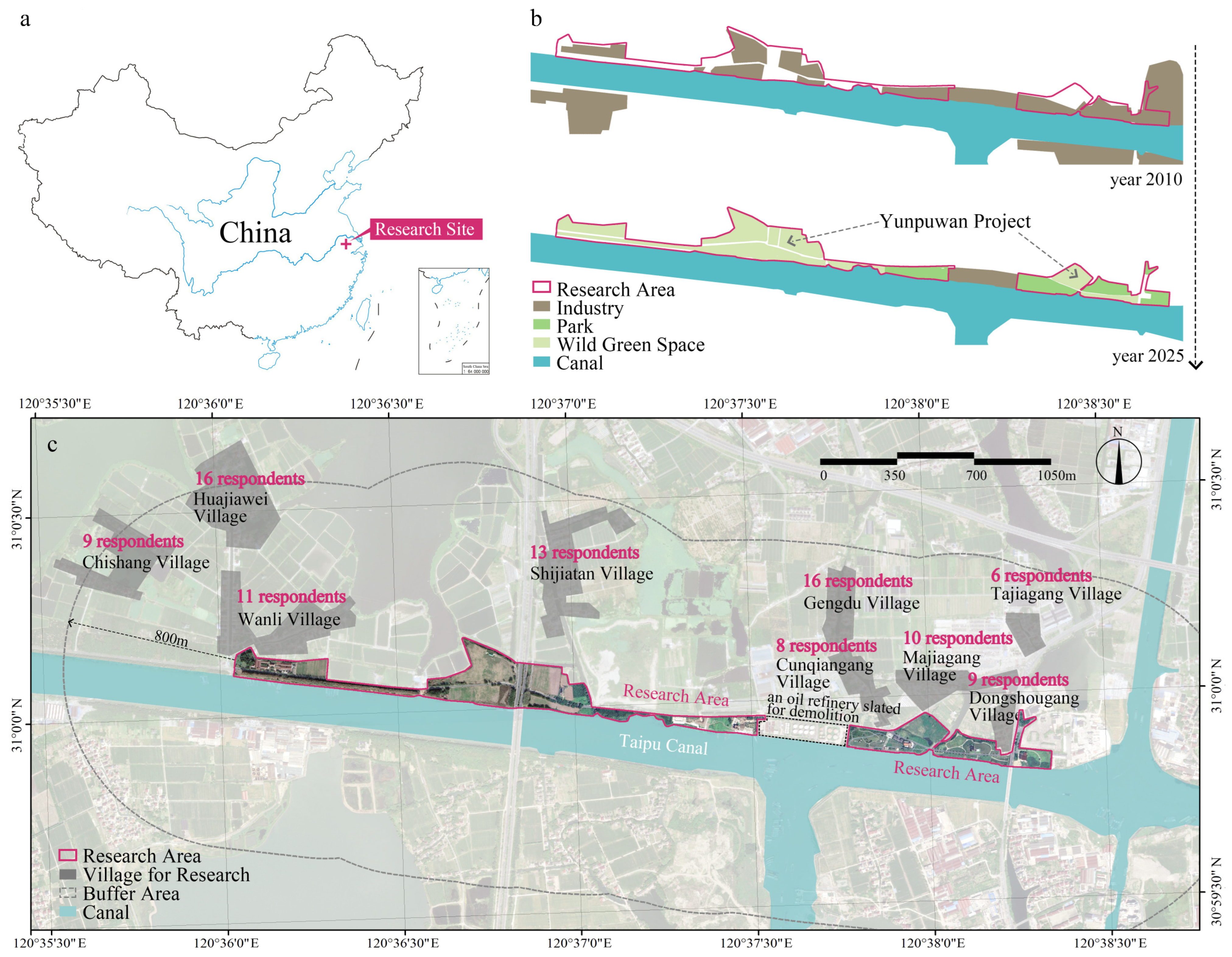
Figure 1. Overview of the study site: (a) Location of the site, (b) Historical land-use transformation, (c) Study area.
Land 14 02204 g001
Figure 2. Research framework.
Land 14 02204 g002
Figure 3. Sampling Points of Representative Photographs.
Land 14 02204 g003
Figure 4. Winning probabilities of the photographs.
Land 14 02204 g004
Figure 5. Spatial autocorrelation and spatial interpolation results. (a) Spatial interpolation of landscape preference scores. (b) Local spatial autocorrelation (LISA) results showing clusters: southern green space of Wanli Village (A), both sides of Jiangcheng Avenue (B, C), and southern green space of Cunqiangang Village (D).
Land 14 02204 g005
Table 1. Operationalization of Environmental Justice in Rural Post-Industrial Landscapes.
Justice TypeDefinitionMeasurementReferences
Recognition Justice Respect for residents’ identities, cultures, and landscape experiences, including industrial-memory elementsPaired photo preference; landscape characteristics quantification; semi-structured interviews; discrete choice model[33,34,35,36]
Participatory JusticeResidents’ involvement in planning, decision-making, and feedbackSemi-structured interviews; discrete choice model[33,34,37]
Distributive JusticeFair spatial distribution and accessibility of landscape benefitsGlobal Moran’s I, LISA, Spearman’s correlation[33,34,38]
Table 2. Quantification methods for landscape characteristics.
Landscape TypeLandscape CharacteristicsMeasurementNotes
industrial heritage and landscapeindustrial heritage (%)percentageindustrial heritage retained or adapted from former factories
industrial-memory landscape (%)percentageincluding large on-site signage, industrial-memory installations, and special paving
natural landscapeherbaceous (%)percentageincluding flowering herbs, lawns, aquatic plants, and climbers
shrub (%)percentage
tree (%)percentage
total vegetation (%)percentagesum of trees, shrubs, and herbaceous cover
vegetation naturalnessmanual scoring1 = horticulturally formal; 5 = wild
water bodies (%)percentageincludes rivers and ponds, but excludes temporary standing water
waterfront accessmanual codingpresent (1) or absent (0); whether conditions allow activities or viewing at the water’s edge
sky openness (%)percentagepercentage of visible sky
hardscapepedestrian paths (%)percentage
plazas (%)percentage
service buildings (%)percentageexcluding off-site buildings and buildings that are not service-oriented
vehicular infrastructure (%)percentageparking lots and carriageways
total hardscape (%)percentageincludes all types of paved grounds and facilities
parking lotsmanual codingpresent (1) or absent (0)
Table 3. Overview of the questionnaire content.
CodeItem (Construct) *Options (Coding) *
Q1gender (gender)male (1); female (0)
Q2village where you live
Q3age group (age)60+ (6); 51–60 (5); 41–50 (4); 31–40 (3); 26–30 (2); 18–25 (1); under 18 (0)
Q4How many years have you lived in this village? (years)
Q5highest educational attainment (education)graduate and above (4); bachelor’s degree (3); junior college/associate (2); high school/technical secondary (1); junior high and below (0)
Q6–Q16paired-choice tasks: Which option do you recognize more, consider more suitable for local villagers to use, and prefer more?example:
Land 14 02204 i001
Q17Before this survey, did you know about the Yunpuwan green space project? (awareness)yes (1); no (0)
Q18Have you ever used the Yunpuwan green space? (use)often (2); occasionally (1); never (0)
Q19Have you ever worked at the factory here? (work history)yes (1); no (0)
Q20During the implementation of this project, did you offer any suggestions? how were they acted upon?open-ended response
Q21Do you currently have any suggestions for this project?open-ended response
Q22From your perspective as a villager, do you recognize this project overall? (Overall recognition)Yes, this project meets our needs (2)
Neutral, this project meets some of our needs (1)
No, this project is not favorable to us (0)
* Items in parentheses under the “item (construct)” column indicate constructs used for subsequent interaction analyses; numbers in the “options (coding)” column show the categorical coding scheme.
Table 4. Socio-demographic profile of villagers.
ItemOptionFrequency%
genderfemale4848.98
male5051.02
ageunder 1833.06
18–2555.10
26–3022.04
31–4088.16
41–5099.18
51–6088.16
60+6364.29
years lived in this village1–20210.21
20–40170.17
40–60170.17
60–80390.40
80+40.04
educationjunior high and below8081.63
high school/technical secondary88.16
junior college/associate33.06
bachelor’s degree44.08
graduate and above33.06
Table 5. Discrete choice model results excluding interaction terms.
VariableβClustered Std. Errorzp95% CI Lower95% CI Upper
vegetation naturalness−0.17610.0612−2.87900.0040−0.2959−0.0562
plazas−0.36130.1284−2.81390.0049−0.6130−0.1096
industrial heritage−0.19350.0732−2.64260.0082−0.3371−0.0500
pedestrian paths−0.19790.0913−2.16690.0302−0.3768−0.0189
hardscape0.94150.47052.00120.04540.01941.8637
This table only includes variables with statistically significant effects.
Table 6. Results of interactions with socio-demographic characteristics.
VariableγClustered Std. Err.zp95% CI (Low)95% CI (High)
industrial-memory landscape × gender0.45530.19302.35940.01830.07710.8336
industrial heritage × work history0.23830.10222.33070.01980.03790.4386
water bodies (%) × years of residence0.42030.19112.19870.02790.04560.7949
total hardscape (%) × years of residence3.37231.59962.10820.03500.23716.5074
waterfront access × project awareness0.31080.14852.09200.03640.01960.6019
sky openness (%) × years of residence2.39431.21781.96610.04930.00754.7812
Table 7. Summary of respondents’ suggestions.
CategorySpecific CommentRespondent ID
landscape design optimizationtoo much grass04
unsafe along the riverbank19
not interesting73
nothing there94
removal of industrial artifacts; feels mismatched96
add more greenery/planting98
amenity provisionadd more green amenities and some exercise facilities09
lack of public toilets14
need a supermarket29
need outdoor fitness equipment32
too far away49
access road is too narrow; should be widened and have higher greening rate78
local economy & livelihoodslow footfall, poor publicity, lack of commercial services28
suggest introducing folk-culture activities66
elderly residents have lost job opportunities; situation is chaotic72
factory buildings demolished, no job opportunities89
project implementationsufficient publicity/outreach30
merely turned into a park46
accelerate progress56
Disclaimer/Publisher’s Note: The statements, opinions and data contained in all publications are solely those of the individual author(s) and contributor(s) and not of MDPI and/or the editor(s). MDPI and/or the editor(s) disclaim responsibility for any injury to people or property resulting from any ideas, methods, instructions or products referred to in the content.