1. Introduction
Rural settlements are the spatial carriers of rural development, and population is a key variable that alters and reshapes these settlements. Globally, the population continues to shift towards urban areas [
1], and the process of urbanization is steadily advancing. Against this backdrop, countries worldwide commonly face an imbalance between urban and rural populations [
2]. Rural settlements are confronted with a series of issues triggered by population mobility, including rural population loss [
3], aging [
4], and low land utilization efficiency [
5]. Against the global consensus on intensive land resource utilization and balanced urban–rural development, comprehensively addressing the challenges of rural settlement utilization efficiency through various means has become a critical breakthrough for countries to promote sustainable urban and rural development.
In China, with the continuous advancement of urbanization, the de-agrarianization of the rural population has led to a series of issues, such as the loss of agricultural labor, idle and abandoned settlements, which have extensively negatively impacted the rural living environment [
6]. This has made the optimization of rural settlement utilization efficiency a key focus for both the government and academic circles [
7]. To address the challenges in rural development, the Chinese government officially proposed the rural revitalization strategy in 2017. This strategy aims to revitalize endogenous drivers of rural development by reshaping the allocation patterns of key elements such as rural population, land, and industry. The dynamic changes in the rural population have led to profound transformations in human settlement patterns, compelling the integration of rural settlement resources and the optimization of community life circle elements. This has triggered a paradigm shift in the supply-demand relationship of rural living spaces. As a critical zone connecting central urban areas and rural hinterlands, metropolitan suburbs exhibit active flows of various elements. However, due to rapid urbanization and continuous rural-urban migration, they face issues such as high vacancy rates in rural settlements [
8] and a decline in multifunctional characteristics [
9,
10], indicating significant room for improvement in their utilization efficiency. Reasonably evaluating and planning the utilization of rural settlements in metropolitan suburbs is of great significance for promoting rural economic development and improving the quality of life for rural residents.
Research on rural settlements is established on the foundation of understanding the overall locality and rurality of the countryside [
11,
12]. The strengthening of rural spatial awareness and improved accessibility of geographic information have gradually guided it toward quantification, shifting from regression analysis reliant on traditional statistical data to information mining through multi-source data integration. The identification of the evolution mechanisms of rural settlements has transitioned from primarily considering natural geographical environmental influences to focusing on the composite analysis of natural and human factors. This process involves elements such as topography, hydrology, population, industry, transportation, and land quality [
13,
14]. Studies generally agree that urbanization, industrialization, and agricultural modernization have facilitated the flow of production factors between urban and rural areas. This movement of elements is considered a primary driver of the evolution of rural settlement [
15]. Current research on rural settlements primarily focuses on the following aspects: utilization efficiency and intensive/conservation-oriented use of rural settlements [
16,
17], functional division and transformation of rural settlements [
18,
19,
20], consolidation [
21,
22,
23], and spatial layout optimization of rural settlements [
24,
25]. Among these, research methods for evaluating rural settlement utilization efficiency have gradually diversified and become more refined, making it one of the key research directions in this field. Faced with the need for multi-scale analysis and multi-source data integration, scholars have progressively introduced advanced methodologies such as time geography, behavioral approaches, and activity analysis [
26]. These developments have gradually given rise to innovative research frameworks, with “social sensing” being a representative example [
27]. It is worth noting that, as the spatiotemporal analysis of human activities is fundamentally based on land use characteristics, existing studies generally tend to use land parcels as the basic spatial unit and focus on residents’ behavioral traits as the core research object when conducting refined efficiency assessment [
28,
29]. However, the mainstream of current research still relies on cross-sectional data obtained at a single point in time, lacking dynamic tracking of spatiotemporal changes in the rural population and analysis of the associated patterns in rural settlement utilization efficiency. This limitation results in the neglect of dynamic characteristics in the utilization process of rural settlements, particularly leading to insufficient responsiveness to fluid phenomena such as short-term commuting, land use turnover, and cyclical industrial changes commonly observed in metropolitan suburban villages [
30].
In recent years, with the rapid development of information technology and the internet era, obtaining massive, dynamic, and spatially precise individual-level data has no longer been a challenge. Big data (especially location-based service data) has garnered widespread attention for its existing and potential value, and has been practically applied in research across multiple fields [
31], including daily behavior [
32] and population mobility [
33,
34]. In spatial research [
35] and the exploration of human–land relationships [
36], big data demonstrates significant application potential due to its rich information dimensions, massive sample size, and high coverage rates. It provides a powerful new tool for gaining an in-depth understanding of the dynamic mechanisms behind rural settlement utilization. However, due to the difficulty in obtaining population mobility data at the village level and the inability to directly scale-translate spatial distribution patterns of large-scale population flows [
37], research on land use efficiency of settlements in rural areas—where the characteristics and patterns of population mobility are complex and variable—places higher demands on utilization efficiency, planning, and resource allocation. Currently, research in this field remains largely focused on macro-level perspectives. However, as urban–rural population interactions become increasingly frequent, population mobility in suburban rural areas exhibits strong dynamism and complexity. In contrast, existing dynamic monitoring and micro-level behavioral analysis are still insufficient, making it urgent to enhance the precision and dynamism of research. Mobile phones, as highly prevalent communication devices, generate vast amounts of signaling data characterized by low acquisition costs, extensive coverage, and strong dynamic representation. Research based on mobile signaling data has gradually become a prominent field of study [
38,
39]. Due to its unique capability to accurately depict human activity patterns and dynamic changes at a micro-scale [
40], location-based big data has also demonstrated significant value in research on rural settlement utilization efficiency. By leveraging mobile signaling data, researchers can not only assess the actual Utilization Efficiency of settlements more accurately but also provide scientific evidence and decision-making support for optimizing rural infrastructure, rationally allocating land resources, and promoting sustainable rural development.
Therefore, this study constructs an evaluation index system for Rural Settlement Utilization Efficiency based on mobile signaling data. Combined with an assessment of the suitability for rural settlement development, it proposes a zoning optimization plan for rural settlements, providing decision-making references for the optimized utilization of Rural Settlements in metropolitan suburban areas. The study primarily addresses the following questions: (1) How can population mobility and utilization efficiency of rural settlements in metropolitan suburbs be evaluated? (2) What kind of coupling relationship exists between the utilization efficiency of rural settlements and their development suitability? (3) How can zoning optimization of rural settlements be conducted based on the efficiency-potential relationship? This study provides zoning optimization proposals for different types of rural settlements, offering important intellectual support for exploring the construction of livable, workable, and beautiful villages with regional characteristics.
3. Methods
3.1. Analysis Framework
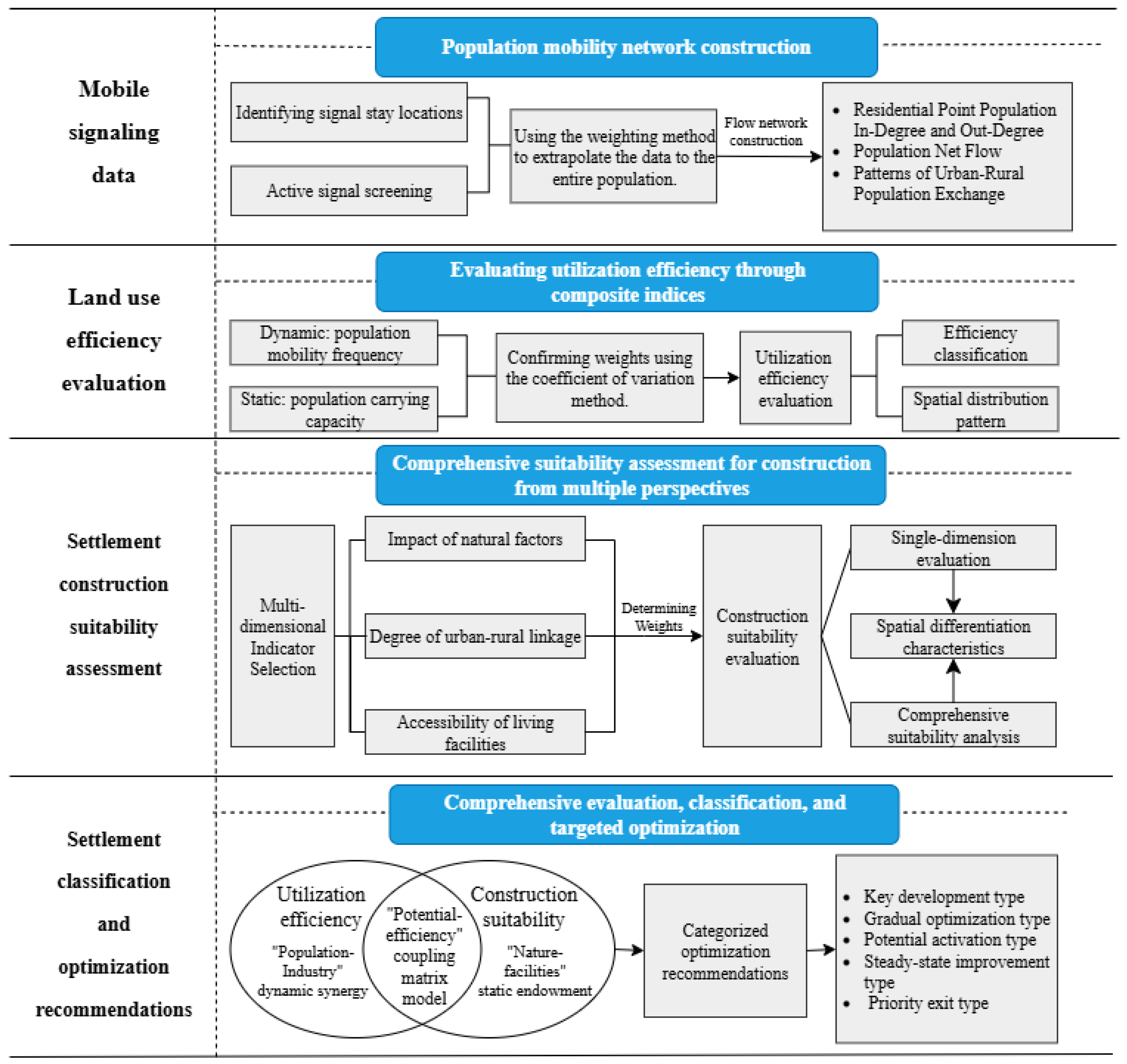
This study investigates the evaluation and optimization of settlement utilization efficiency in metropolitan suburban rural areas from the perspective of population mobility, primarily encompassing the following five progressive steps (
Figure 2):
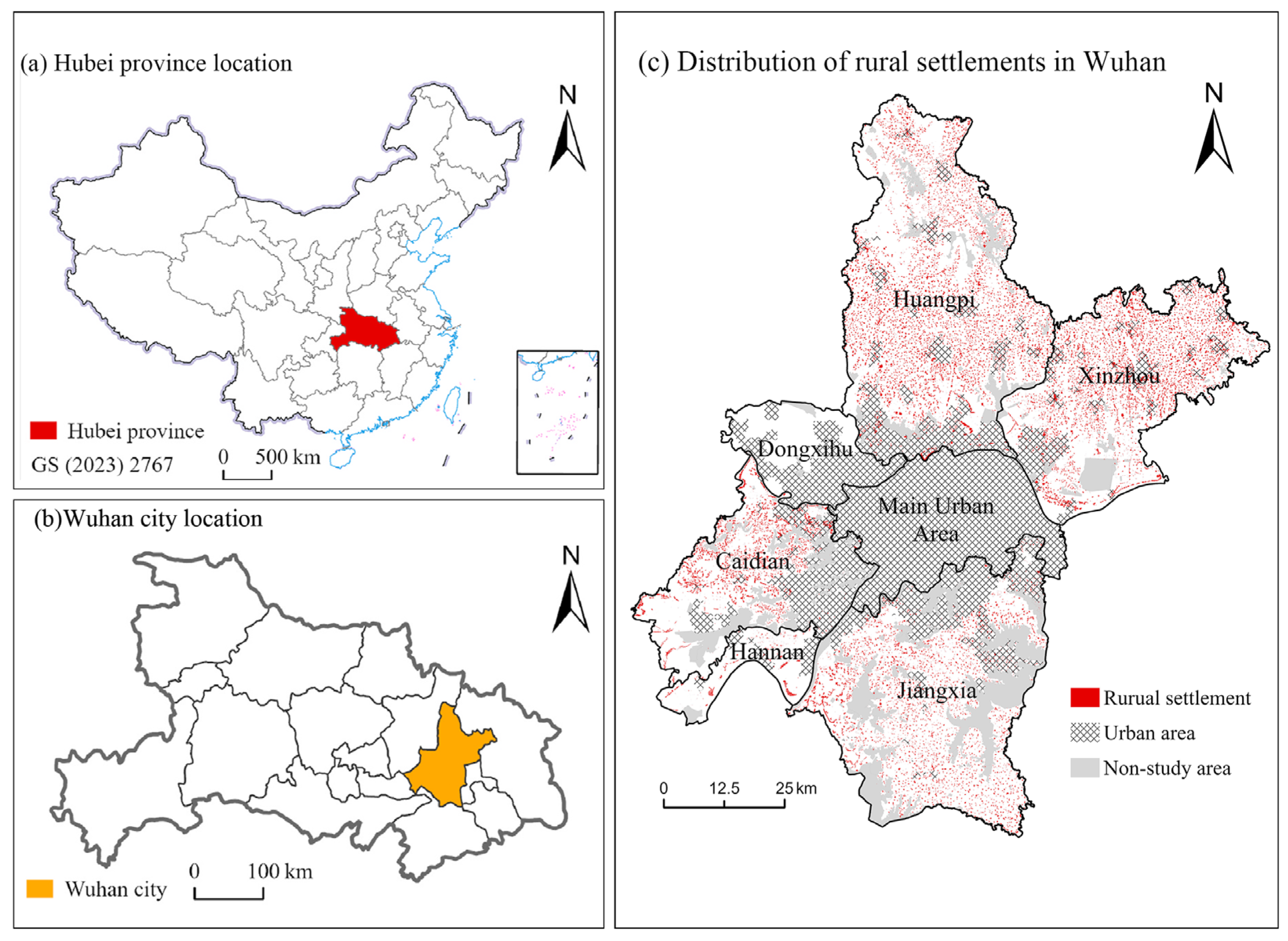
First, a population mobility network for settlements was constructed. Based on population travel data from June 2019 in Wuhan, statistical analysis of cross-unit mobility was conducted to capture the spatial characteristics of population flows that reflect rural functions and spatial structures.
Second, from a dynamic perspective and integrating population mobility features, two indicator systems were developed using multi-source data: one for evaluating settlement utilization efficiency and another for assessing development suitability.
Next, based on the previously constructed population mobility network, the spatiotemporal patterns and spatial variation in rural population distribution and mobility were extracted and analyzed, with data reliability validated.
Subsequently, the indicator systems were applied to quantitatively evaluate the utilization efficiency of residential land and development suitability for each village.
Finally, a coupling analysis was conducted by integrating the results of efficiency and suitability evaluations, leading to the proposal of tailored zoning optimization pathways for different categories of settlements based on local conditions.
3.2. Calculation of In-Degree, Out-Degree, and Net Flow
In observing specific mobility patterns, a single signaling event can be regarded as a dynamic process from an origin point to a destination point. By statistically analyzing the population inflow and outflow for each village in Wuhan, the in-degree (
) and out-degree (
) for each village during the month were obtained. The net flow of a node was calculated as the difference between the two, revealing the population attraction or spillover effect of the village [
41].
The formulas for calculating in-degree and out-degree are as follows:
3.3. Evaluation of Rural Settlement Utilization Efficiency
To evaluate the utilization efficiency of rural settlements, this study adopts two dimensions: dynamic mobility and static carrying capacity. Based on the synergistic relationship between population mobility characteristics and land carrying capacity, the following core indicators are defined, respectively:
Population Mobility Activity Index (PMAI): Calculated by dividing the total monthly population inflow and outflow of a single village by the total area of the settlement. This index reflects the settlement’s attractiveness to population movement. A higher PMAI indicates greater utilization efficiency. The formula is as follows:
In the formula, An represents the inflow population of any village on day n, Bn represents the outflow population of the same village on day n, and G represents the total area of rural settlements within that village.
Population Carrying Efficiency Index (PCEI): Calculated by dividing the total number of resident population accumulated in all settlements within a single village over one month by the total area of the settlements. This index reflects the population carrying capacity per unit area of land. A higher carrying capacity indicates greater land utilization efficiency. The formula is as follows:
In the formula, Cn represents the number of residents in the village on day n, and G represents the total area of rural settlements in the village.
The study employed the coefficient of variation method to determine the weights of the two indices [
42]. The introduction of the coefficient of variation method more objectively reflects the relative importance of the evaluation indicators, avoids the subjectivity inherent in expert scoring processes, and effectively reduces the interference of extreme values. After classifying the factors into hierarchical levels, scores of 1–3 were assigned to the levels from low to high. Weighted calculations were then performed based on the computed weights to obtain the utilization efficiency scores for each village.
3.4. Rural Settlement Suitability Evaluation
When constructing the evaluation index system for rural settlement suitability, this study employed GIS spatial analysis methods and selected elevation, slope, and relief degree as fundamental evaluation indicators. An evaluation system was established by integrating natural conditions, urban–rural linkages, and spatial accessibility (
Table 1). Although water bodies are not potential sites for rural residential areas, their proximity to settlements influences development; therefore, the distance to water systems was incorporated into the evaluation. In terms of urban–rural linkages, the proximity of settlements to the main urban area and the degree of urban–rural connectivity were used to reflect the closeness of nodal connections between urban and rural areas. Furthermore, transportation, commercial, medical, and science-education facilities are essential for daily rural life. This study characterized spatial accessibility by measuring the commuting time cost to reach these facilities, thereby assessing the convenience of daily living [
43].
During the accessibility analysis, the land use types within the study area were categorized into three major classes: transportation land (excluding railways, streets, airports, port terminals, and pipeline transport land), water bodies and water conservancy facility land, and other land types. With reference to the “Technical Standard of Highway Engineering (JTGB01-2003)” [
44], and considering road network density and quality, the actual operating speeds are set as follows [
45]: provincial highways 60 km/h, county roads 35 km/h, and rural roads 15 km/h. Water bodies and water conservancy facility land significantly impede accessibility and are treated as impassable barriers. Based on the degree of restriction imposed by other land types on passage, they are classified into Category I (commercial and service land, industrial and mining storage land, residential land, public management and public service land, special-use land, urban–rural and industrial-mining land, as well as airport land and port terminal land within transportation land), Category II (cultivated land, garden land, vacant land, facility agricultural land, and field ridges), and Category III (forest land, grassland, saline-alkali land, marshland, sandy land, and bare land). Each category is assigned a different travel speed: Category I at 15 km/h, Category II at 4 km/h, and Category III at 3 km/h. Based on the above classifications and travel speeds, the time cost required to traverse a unit distance (30 m) for different land use types is calculated as follows: provincial roads 0.030 min, county roads 0.051 min, rural roads 0.120 min, Category I land 0.120 min, Category II land 0.450 min, and Category III land 0.60 min.
The measurement process of spatial accessibility is as follows: First, identify the sources and their corresponding weights. Then, based on the time cost per unit distance for different land use types, generate a 30 m resolution cost raster within the township area using ArcMap (v10.6). Next, utilize the Path Distance analysis tool, with elevation as a correction factor, to generate spatial accessibility rasters for each source. Finally, apply the Raster Calculator tool to standardize the spatial accessibility rasters of each source according to their assigned weights and perform a weighted summation to obtain the spatial distribution raster of production and living accessibility.
The study employed the coefficient of variation method to assign weights to each indicator, resulting in the following weights for the indicators in the suitability system, as shown in
Table 1. After integrating and grading the factors, scores of 1–3 were assigned to the levels from low to high, respectively. Weighted calculations were then performed based on the computed weights to obtain the construction suitability scores for each village.
4. Results Analysis
4.1. Spatial Patterns of Rural Population Mobility
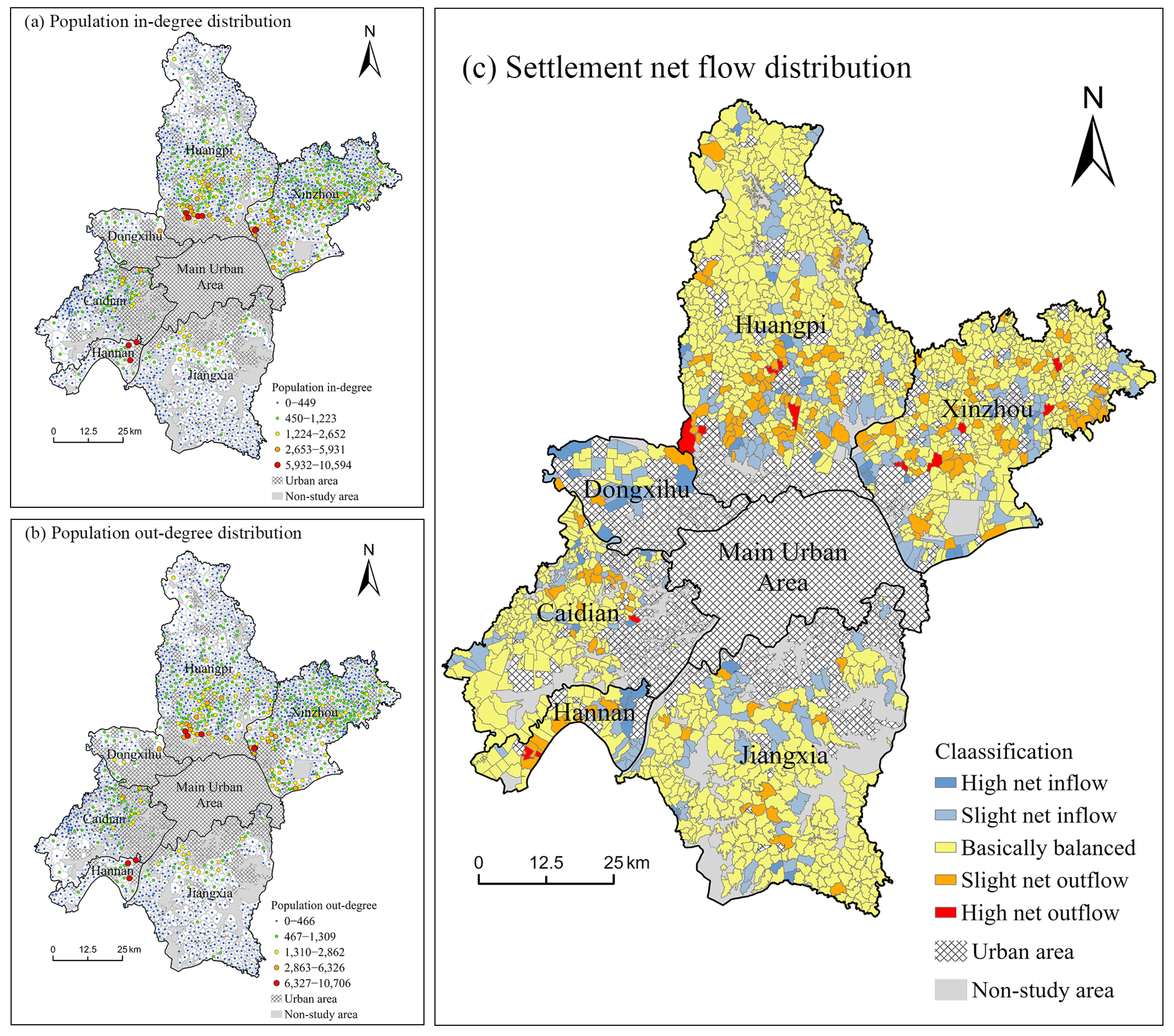
There are significant differences in both in-degree and out-degree among villages in Wuhan, with substantial variations in flow volumes across different regional units. Based on the difference between village in-degree and out-degree, rural population mobility is categorized into five levels: high net outflow, slight net outflow, balanced inflow and outflow, slight net inflow, and high net inflow (
Figure 3). When the net flow difference in a village is within 10 person-times, it is considered to have essentially balanced inflow and outflow, indicating a relatively stable state. When the difference between population in-degree and out-degree falls within the range of 10–50, it is considered a slight net inflow/net outflow. When the degree difference exceeds 50, it is regarded as a high net inflow/net outflow. From an overall spatial distribution perspective, the patterns of out-degree and in-degree are highly similar, exhibiting a spatial structure centered on the main urban area and radiating toward surrounding towns. Active areas are primarily concentrated in urban zones and their peripheries, while mobility frequency significantly decreases in rural regions. There is extensive population exchange between the main urban area, other urban regions, and surrounding villages. Some individuals may commute back and forth, significantly increasing the in-degree and out-degree of these villages. Areas with high frequencies of population inflow and outflow are distributed in small pockets of the eastern part of Hannan District, the southern part of Huangpi District, and the southwestern part of Xinzhou District—all located in the near suburbs of the main urban area. In contrast, villages on the urban periphery generally exhibit lower frequencies of population mobility.
The results indicate that among the rural areas of Wuhan, 924 villages are in a state of basic population balance, 40 villages are classified as high net-outflow villages, and 171 as low net-outflow villages; meanwhile, 13 villages are identified as high net-inflow villages, and 158 as low net-inflow villages. The areas surrounding and peripheral to the main urban center are the primary regions experiencing net population outflow, mainly due to two reasons. On one hand, the ample employment opportunities, comprehensive public services, and diverse leisure resources in the main urban area create a strong attraction for the surrounding rural population, prompting their concentration toward the city. On the other hand, the peripheral regions exhibit lower levels of economic development and insufficient growth momentum, driving local residents to seek better living conditions elsewhere and exacerbating population loss. In contrast, villages with net population inflow are mostly distributed in the suburban areas close to the city. Population growth in these regions primarily stems from two groups: commuters who travel between urban and rural areas choose to settle here, and some short-term migrants returning to their places of origin. Additionally, some villages maintain essentially balanced population flows. Such villages typically experience low levels of both population inflow and outflow, with limited connections to external areas, resulting in a relatively stable overall population size.
4.2. Characteristics of Settlement Utilization Efficiency
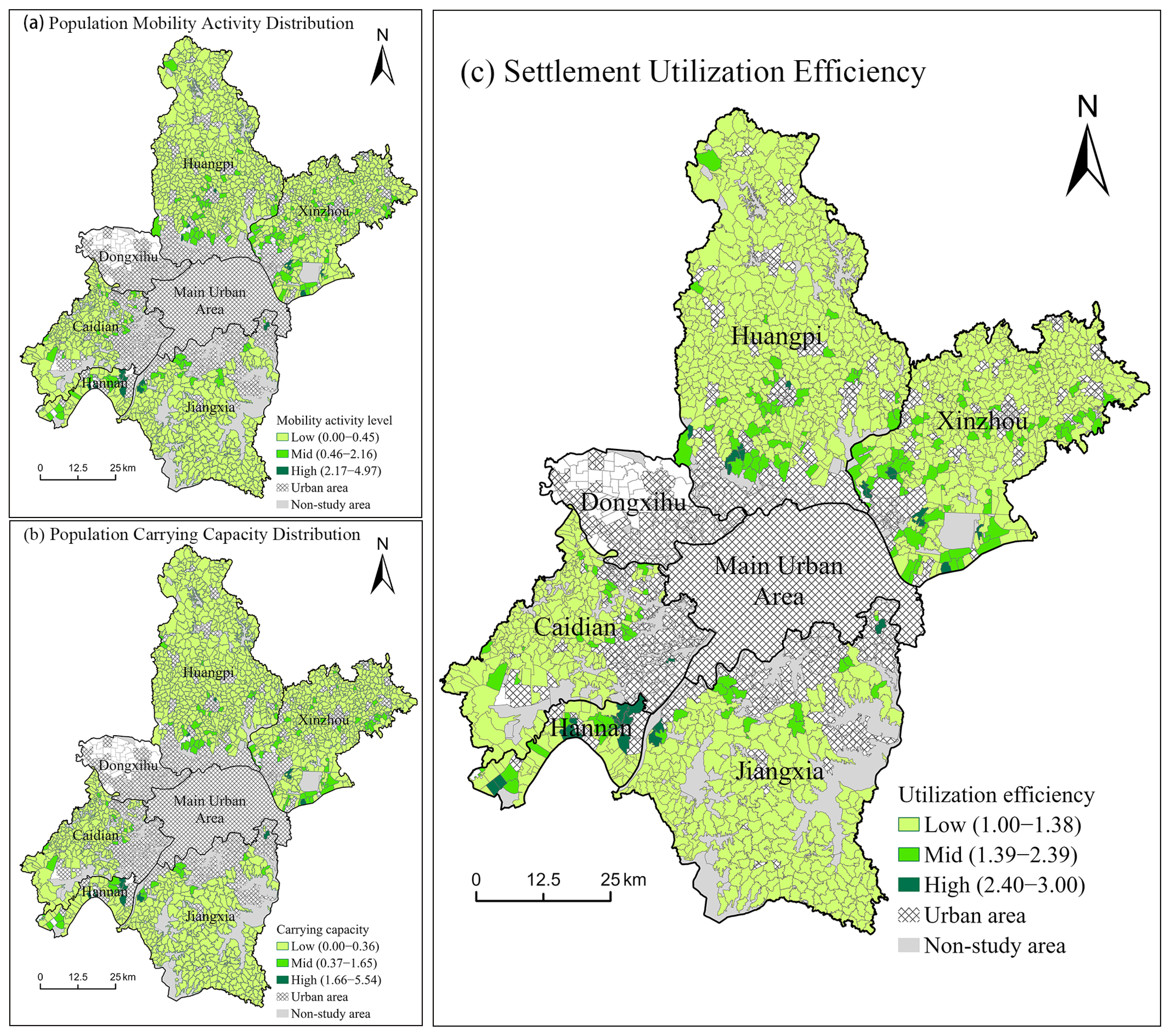
To capture both the dynamic mobility and static carrying capacity within rural human–land relationships, the study integrated the Population Mobility Activity Index (PMAI) and the Population Carrying Efficiency Index (PCEI). Using the natural breaks method, the utilization efficiency of settlements within the research scope was classified into three levels—low, medium, and high—reflecting the differentiated distribution of settlement utilization efficiency (
Figure 4). Within the study area, villages with medium to high PMAI levels account for only 9.61%, while those with medium to high PCEI levels make up merely 6.78%. High-efficiency areas constitute less than 10% in both categories. Additionally, villages with a low level of PMAI and PCEI account for 90.39% and 93.22%, respectively. The data indicates that the overall dynamic mobility within the villages of the study area is superior to their static carrying capacity. However, the vast majority of villages exhibit low levels of both permanent residents and active mobile populations.
According to the classification results, high-utilization-efficiency villages account for only 1.71% of the suburban villages in Wuhan, medium-utilization-efficiency villages make up 9.74%, and low-utilization-efficiency villages constitute 88.6%. The data indicates that the utilization of rural settlements in most villages is insufficient. Medium- and high-efficiency utilization villages collectively account for 11.45%, forming a stark contrast with the high proportion of low-efficiency villages. The overall utilization pattern exhibits a pyramid structure, suggesting that settlements in the study area still possess significant potential for development and optimization. Spatially, the distribution of various village types is uneven. The vast majority of medium- and high-efficiency villages are concentrated in the urban core and its surrounding areas, showing a certain “concentric circle” pattern of decay. Furthermore, significant disparities in land use efficiency exist across different administrative districts: Hannan, Xinzhou, and Huangpi districts have a higher proportion of medium- and high-efficiency villages, while Caidian and Jiangxia districts generally exhibit lower efficiency levels. This regional variation may reflect imbalances in local policy implementation intensity and economic development levels.
4.3. Suitability Evaluation of Rural Settlements
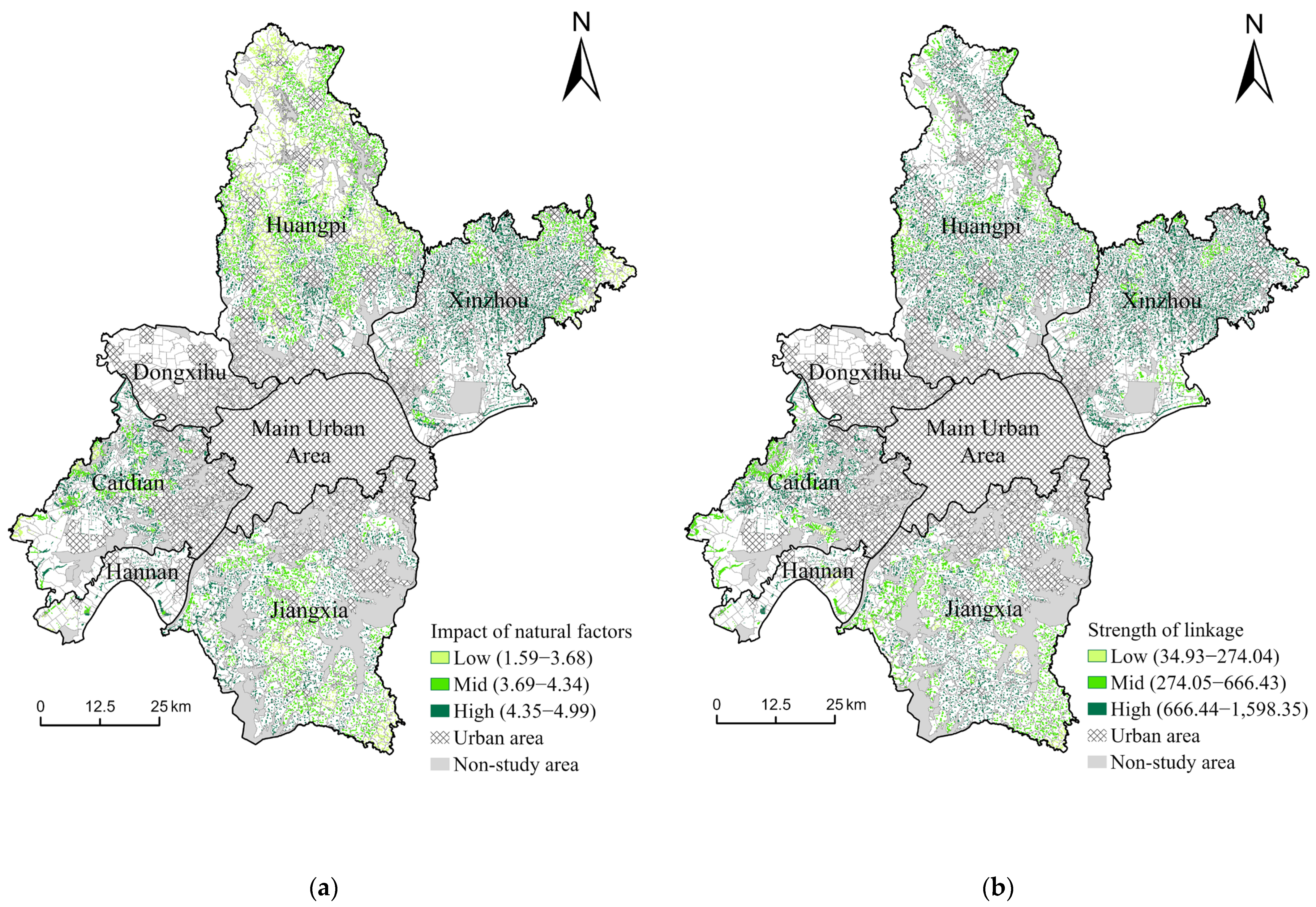
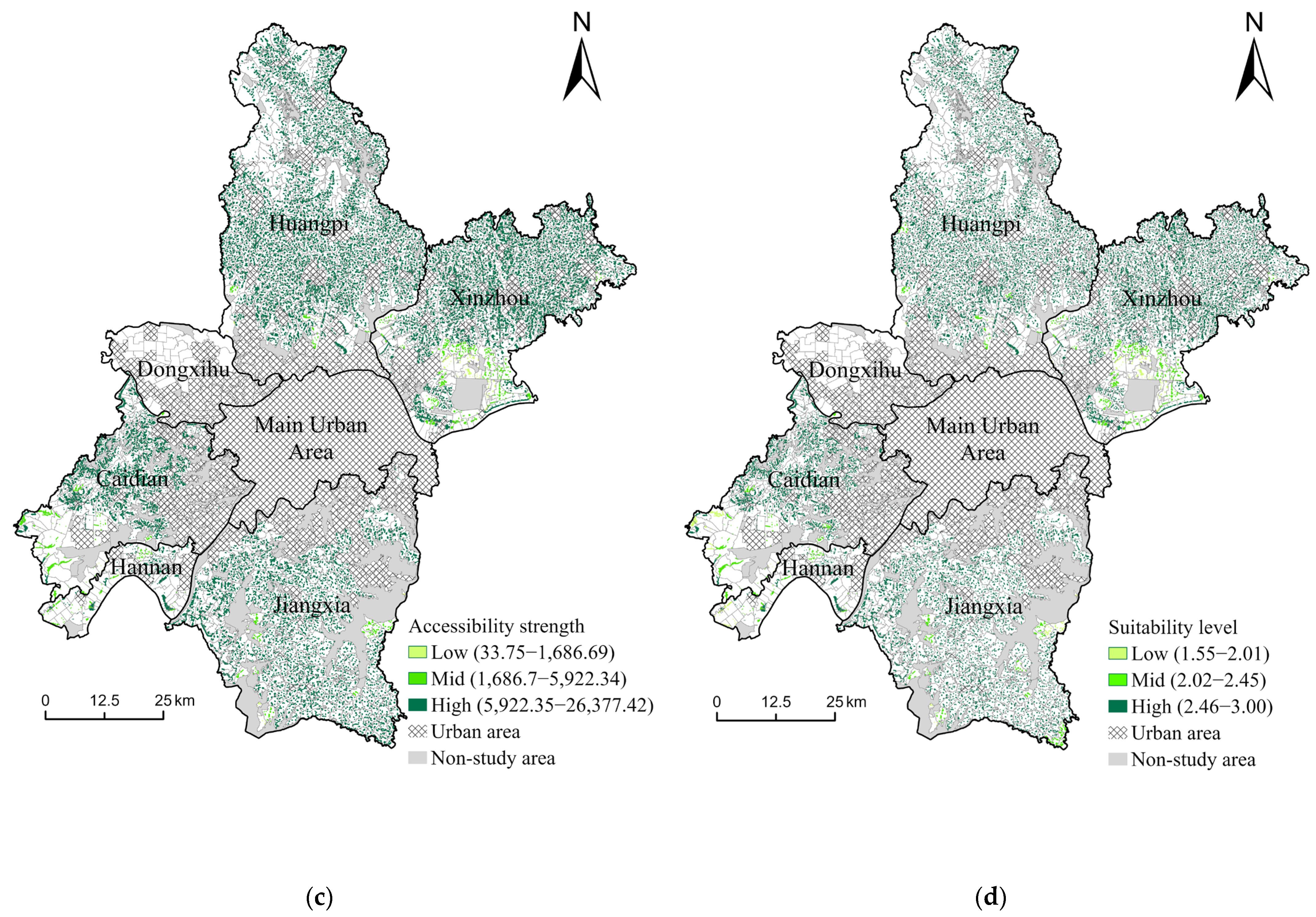
Rural settlements in Wuhan generally exhibit high overall residential suitability and significant development potential. Spatially, they demonstrate a distribution characteristic of “high suitability across the entire area, with weaknesses at the edges.” The development suitability of rural settlements is influenced by three factors: natural conditions, urban–rural linkage levels, and livelihood accessibility. By applying weighting, the specific distribution of development suitability was obtained, and settlements within the study area were classified into low, medium, and high levels using the natural breaks method (
Figure 5). Among these, high-suitability areas exhibit a “center-periphery” spatial distribution, with key regions demonstrating prominent advantages. Medium- and low-suitability areas account for an extremely low proportion, are concentrated in distribution, and face clear constraints.
In terms of natural conditions, high-suitability areas account for approximately 53.25%, medium-suitability areas for about 35.62%, and low-suitability areas for around 11.13%. High-suitability zones are predominantly distributed in Xinzhou District, eastern Huangpi District, and parts of Jiangxia District, characterized by flat terrain, abundant water systems, and stable geology, which are conducive to large-scale settlement development. These areas offer advantages such as low difficulty in infrastructure construction and reduced development costs, facilitating the integration of settlement development with industries like agricultural operations and rural tourism to achieve more efficient land utilization. Medium-suitability areas are primarily located in central Huangpi District and northern Jiangxia District, featuring moderate terrain undulation that may still require localized optimization. These regions are suitable for mixed-use settlement development, combining the optimization of residential facilities and environments with the promotion of local characteristic industries to achieve more sustainable settlement construction. Low-suitability areas are concentrated in the northwestern part of Wuhan (such as the mountainous western region of Caidian District) and urban fringe zones. These regions face challenges such as complex terrain, inconvenient transportation, limited facilities, and ecological constraints, resulting in higher construction difficulties and costs. Before developing settlements, it is necessary to enhance livability through engineering measures such as land leveling and road construction. Some areas may involve ecological protection red lines, prohibiting large-scale settlement development.
In the urban–rural linkage hierarchy, high-level areas account for 73.08%, medium-level areas for 25.70%, and low-level areas for 1.22%. The urban–rural linkages in Wuhan’s rural areas overall exhibit a pattern of “high proportion, strong radiation,” reflecting the deep integration of urban and rural areas during the urbanization process. High-level areas typically feature relatively complete facilities for daily life, exhibit high economic dependence on cities, and maintain close urban–rural population interactions, with a certain degree of “urban–rural amphibious” phenomenon observed. Medium- and low-level areas are concentrated around water bodies and the edges of distant urban districts, where urban–rural economic linkages are weaker and geographic isolation has a more severe impact. Local industrial development is constrained by a lack of synergy, potentially leading to a series of issues such as reduced employment opportunities, population outflow, and increased vacancy rates in settlements. This results in a waste of resources characterized by “good land without viable industries”.
In terms of livelihood accessibility, high-level areas account for 94.35%, while medium- and low-level areas make up only 5.65%. The extremely high proportion of high-accessibility regions directly reflects Wuhan’s success in infrastructure construction and the provision of living facilities. The vast majority of villages within the study area maintain close connections with urban zones, ensuring relatively convenient commuting, medical access, and shopping for residents. This reflects the highly developed infrastructure and extensive coverage of facility services in Wuhan. High accessibility signifies strong development potential for settlements, making these areas suitable for urban–rural integrated community renovations. Medium- and low-accessibility areas are sporadically distributed in Hannan District, southwestern Caidian District, and southeastern Xinzhou District. These regions suffer from incomplete infrastructure and uneven service coverage, potentially leading to severe population outflow, settlement vacancy, and even the emergence of hollowed-out villages.
Weighted results indicate that high-suitability areas account for 94.50% of rural settlements in Wuhan’s distant urban districts, demonstrating that the vast majority of rural areas in Wuhan possess excellent natural conditions, close urban–rural relationships, and high accessibility to living facilities, indicating significant development potential. Among the six suburban administrative districts, five (excluding Dongxihu District) have over 90.00% of their area classified as highly suitable. Huangpi District, which contains the largest number of villages, shows a remarkably high suitability proportion of 98.28%. Dongxihu District, the only area below the 90.00% threshold, accounts for merely 2.25% of the total studied villages. High-suitability settlements spatially exhibit a certain “center-periphery” diffusion pattern, with particularly high proportions of such areas in Jiangxia District and Huangpi District. These areas simultaneously benefit from favorable natural conditions, close urban–rural linkages, and well-developed public services, creating a positive synergistic effect. Their multi-dimensional advantages and inherent potential for population aggregation make them ideal candidates for future focus on rural population concentration and settlement optimization. Medium- and low-suitability areas account for only 5.50% of the total area, with medium suitability comprising approximately 4.32% and low suitability about 1.18%. Typically located far from the main urban center and geographically marginalized, these areas experience limited economic development due to weakened influence from urban radiation. Some areas are also constrained by ecological protection policies because of their proximity to lakes or wetlands. For such areas, ecological migration can be encouraged, ecological compensation strengthened, and improvements pursued through exploring new resource allocation models. Overall, the suitability of rural settlements in Wuhan exhibits a pattern of “high suitability across the entire area, with low-lying areas at the edges”. Building on this strong foundation, future efforts can integrate spatial governance, policy innovation, industrial empowerment, and other diverse approaches to achieve high-quality synergistic development between urban and rural areas.
4.4. Zoning Optimization of Rural Settlements Based on the “Potential-Efficiency” Matrix
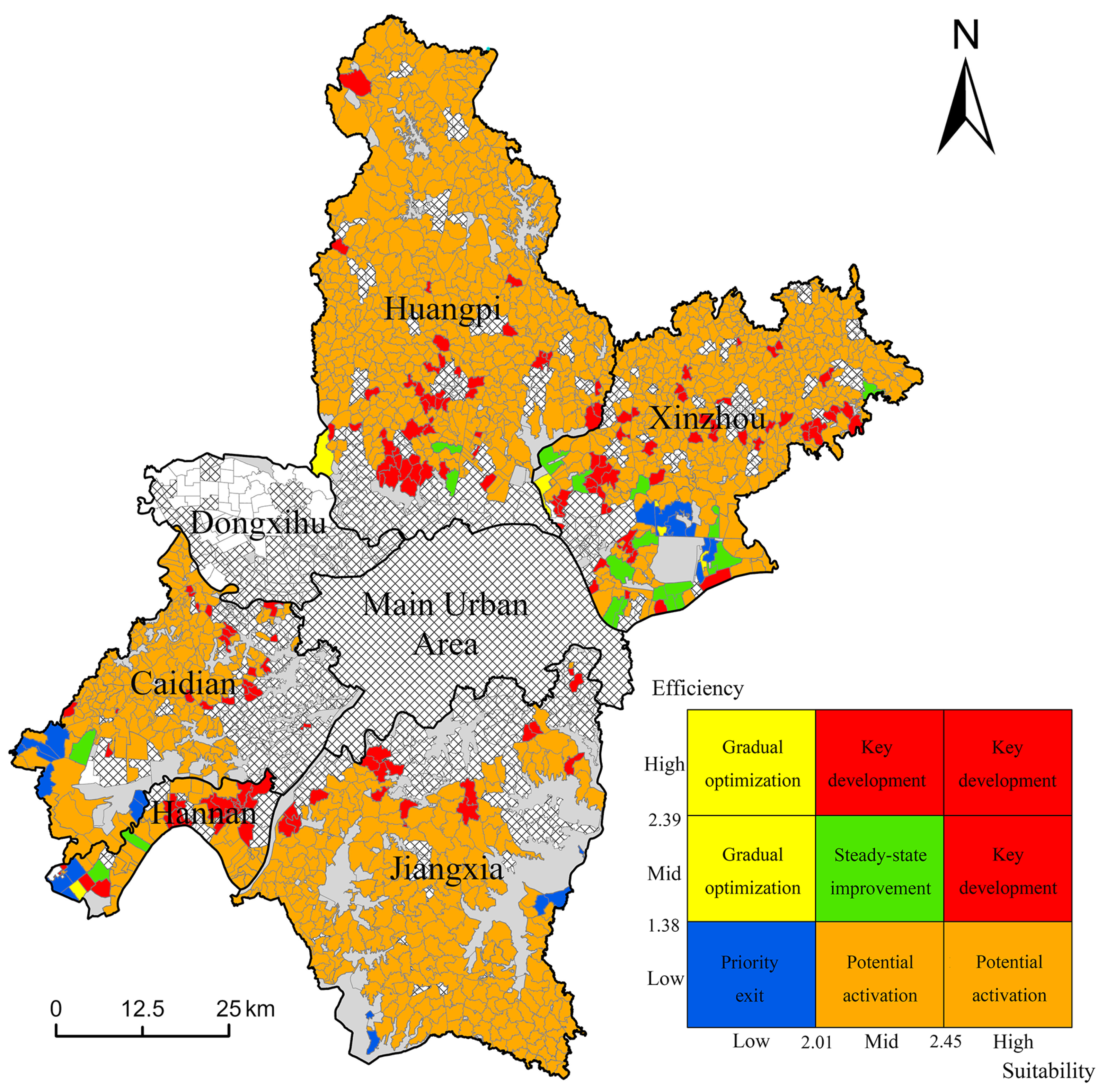
To provide targeted optimization suggestions for villages with different development conditions based on local circumstances, the study constructed a 3 × 3 classification matrix based on the results of settlement utilization efficiency grading and rural settlement development potential evaluation. This matrix categorizes villages within the study area into nine types [
46] (
Figure 6). During the matrix construction process, this study correlates the combination of current land use status and future development potential levels with specific village types. The classification boundaries are determined using the natural breaks method, reflecting natural divisions in data distribution while minimizing subjective influence. To better reflect the characteristics of different villages, the study further integrated and distinguished five village types: key development type, gradual optimization type, potential activation type, steady-state improvement type, and priority exit type. Based on this, clear construction plans and optimization pathways for rural settlements were defined for each type.
Key development type. Villages of this type exhibit medium to high levels of both utilization efficiency and settlement development potential, accounting for approximately 9.67% of the study area. These villages are widely distributed and typically possess advantages such as gentle terrain, proximity to urban areas, frequent population interactions, low development costs, and convenient living facilities. Although land development is relatively well-established, they maintain high attractiveness and development potential due to active population flows and a solid industrial foundation. For such vibrant and high-potential villages, optimization efforts should focus on intensive development and industrial upgrading. For instance, appropriately relaxing floor area ratio restrictions, encouraging the construction of multi-story residences and the utilization of underground space, and promoting three-dimensional development through mixed land use to further enhance land use efficiency. Simultaneously, implementing “new infrastructure” projects to integrate and upgrade existing infrastructure systems, improving public services and residential quality. Additionally, industrial upgrading can be driven by cultivating distinctive industries, transforming residential areas into multifunctional complexes that integrate “residence + industry + services”. Such villages, often adjacent to urban areas, can serve as nodes for bidirectional urban–rural resource flows. By establishing demonstration zones for urban–rural integration, they can attract the return of urban populations and stimulate the vitality of residential area construction and development.
Gradual optimization type. This category comprises villages with medium to high settlement utilization efficiency but low development potential. They are extremely few in number, with only six villages sporadically distributed in urban fringe areas, accounting for only 0.40% of the study area. These villages suffer from poor terrain conditions, low urban–rural connectivity, infrequent interactions with surrounding populations, and limited utilization of various infrastructure due to multiple constraints for local residents. Under the premise that rural settlements in these villages are generally fully utilized and relatively stable, their future development prospects are limited due to generally low livelihood accessibility, insufficient potential for further development, and possible impacts from ecologically sensitive areas. There is little room for major upgrades in any aspect of the settlements. For such villages, efforts should focus on facility transformation and functional renewal, emphasizing the optimization of existing resources and exploring new development directions. Clear optimization strategies must be established to avoid negative impacts on local society and ecology caused by blind expansion. Optimizing existing facility resources can be demonstrated by strictly controlling the construction of new residences, renovating existing buildings to achieve functional replacement of settlements, and implementing green ecological transformations to enhance living quality through environmental optimization. While optimizing existing resources, additional facilities can be added within carrying capacity limits, such as setting up convenience services like parcel delivery, improving basic services like drainage systems, or compensating for the lack of physical facilities through digital transformations like “internet + healthcare/education”.
Potential activation type. This category comprises villages with low settlement utilization efficiency but medium to high development potential, forming the main component of rural settlements in Wuhan’s distant urban districts and accounting for 87.17% of the total villages in the study area. This proportion reflects that rural residential areas in this region generally possess sound theoretical development potential, but actual utilization remains insufficient. Villages with untapped potential enjoy superior natural conditions and close urban–rural linkages, with advantages such as convenient transportation and high infrastructure coverage. However, the widespread vacancy of internal residential sites reveals issues including outdated infrastructure, sluggish industrial development, and severe population outflow. When optimizing such villages, the focus should be on revitalizing underutilized resources and enhancing land use efficiency, transforming idle assets into drivers of development to achieve a transition from “low-efficiency vacancy” to “high-efficiency utilization”. This process can be facilitated through policy-guided industrial cultivation, promoting a dynamic balance between population and industry to attract returning migrants. Additionally, residential area renewal can be achieved by regulating homestead transfers and encouraging concentrated settlement. Prior to physical development, priority should be given to upgrading local infrastructure—improving transportation networks, expanding digital services, and implementing community renovations—to proactively establish high-quality living conditions for potential population growth.
Steady-state improvement type. This category accounts for approximately 1.38% of the total, primarily concentrated around Zhangdu Lake in the southwestern part of Xinzhou District, with only sporadic distribution in other administrative areas. In steady-state improvement-type villages, both the utilization efficiency and development potential of settlements are at a medium level, with potential and efficiency generally balanced. These villages are typically stable but lack significant room for development. They do not face severe resource idle issues nor possess distinct locational or industrial advantages. For such villages, subsequent efforts should adhere to the philosophy of “seeking improvement through stability” to achieve gradual and sustainable optimization. Through refined management and industrial guidance, while progressively optimizing settlement utilization patterns to enhance spatial efficiency, attempts should be made to explore and develop local potential characteristics, improve infrastructure and public services. This will elevate residents’ quality of life and enhance village attractiveness, gradually boosting overall competitiveness while maintaining village stability. For example, allowing certain residential areas to undergo functional renovations, converting scattered idle land into public activity spaces, and collaborating with surrounding villages to develop linked supporting services and industries, etc. Due to limited potential, the development and construction of such villages cannot proceed with “large strides” but should focus on “micro-renovations and refined upgrades”. This involves small-scale, high-precision quality improvements in settlements while avoiding homogeneous competition to ensure sustainable development.
Priority exit type. This category comprises only 21 villages, accounting for 1.38% of the total study area. These are regions where both settlement utilization efficiency and development potential are relatively low, primarily located in remote areas and ecologically sensitive zones. Villages of this type exhibit poor population vitality and low facility coverage. Constrained by natural conditions and other factors, forced investment in resource transformation or industrial introduction may yield minimal results, with no potential for future development as livable areas. Based on this, their development direction should focus on orderly exit, ecological restoration, and functional transformation, gradually adjusting settlements while exploring alternative functions. Subsequent construction in these villages should move away from settlement development, encouraging villagers to relocate to towns or central villages with corresponding policy subsidies, and promoting population outflow to reduce the high costs and low efficiency associated with dispersed living. Existing settlements can be gradually restored to ecological or agricultural land while exploring non-residential functions such as ecological restoration and monitoring. The original settlements and their structures should be partially preserved and repurposed for functional transformation.
5. Discussion
5.1. Coupling Relationship Between Rural Settlement Utilization Efficiency and Suitability
The relationship between rural settlement utilization efficiency and development suitability is not a simple linear correlation but involves a complex interactive mechanism of mutual transformation. The degree of coupling and coordination between the two directly determines the direction and effectiveness of settlement optimization. This relationship can be deeply analyzed from three aspects: spatial coupling characteristics, differences in driving mechanisms, and dynamic evolution trends.
From the perspective of spatial coupling characteristics, areas adjacent to urban markets with convenient transportation typically exhibit high coupling between the two. “High-potential—high-efficiency” villages achieve full utilization of resources through multi-faceted coordination, forming a virtuous cycle. In contrast, “high-suitability—low-efficiency” villages are in a state where potential is significantly underutilized. This mismatch essentially reflects a disconnect between static potential and dynamic utilization—high suitability provides a solid foundation for development, but due to insufficient support from population and industry, the inherent potential struggles to translate into actual efficiency.
From the perspective of driving mechanism differences, the improvement in utilization efficiency stems from the dynamic synergy of “population-industry,” while development suitability depends on the static endowment of “nature-facilities”. Population mobility and industrial vitality are the core driving factors of utilization efficiency. The degree of settlement utilization is directly related to population inflow and the ensuing residential and consumption demands, while industrial development supports population retention. In terms of development suitability, natural conditions determine the cost and feasibility of settlement construction, while infrastructure influences livability and regional attractiveness. In the process of settlement development, the ideal state is to coordinate both factors to form a positive feedback loop of “population aggregation—industrial upgrading—efficiency improvement—facility enhancement—potential strengthening”. Observing from the dynamic evolutionary trends, the relationship between the two will change along with the stages of urban and rural development and policy orientation. During the rapid advancement of urbanization, the radiation effect of urban areas strengthens, and regions with high suitability are more likely to attract population and industrial agglomeration, leading to a rapid increase in utilization efficiency, and the coupling degree between the two gradually improves. During the stage of integrated urban–rural development, the focus shifts to balance and sustainability. Governments place greater emphasis on infrastructure construction and industrial development in distant suburban areas, addressing mismatches and further unlocking the potential of regions with low utilization efficiency.
5.2. Policy Implications for the Optimization of Rural Settlements in Metropolitan Areas
The optimization of rural settlements in Wuhan revolves around two core principles: classified management and sustainable development, aiming to build a differentiated and systematic policy framework. In terms of classified management, targeted strategies should be formulated based on the five village types derived from the “potential-efficiency” matrix, adopting a “location-specific” approach. For key development-type villages, policies should focus on “intensive quality improvement and industrial empowerment”. Under policy guidance, floor area ratio restrictions can be gradually relaxed, facilities can be added and improved, and support for characteristic industries can be strengthened. Integrating industry with human settlements will promote the transformation of settlement land from single-use to multifunctional purposes. For gradual optimization-type villages, policy focus should be on facility transformation and functional renewal. Due to limited development potential, the construction of new facilities should be strictly controlled. Instead, efforts should prioritize the renovation and updating of existing settlements, along with exploring new development directions. For example, implementing policies to revitalize idle homesteads by allowing the conversion of vacant houses into public service facilities such as senior activity centers or village libraries; promoting green ecological renovations by supporting residents in rooftop greening and installing rainwater collection systems to enhance living environment quality; meanwhile, leveraging modern technology to compensate for deficiencies in physical facilities through flexible digital transformation.
At the level of factor coordination policies, while “land-population-industry” factors currently interact, barriers still exist among them. It is necessary to establish linkage mechanisms to ensure the convertibility of these factors. Regarding land factors, the government can intensify the reform of the “three rights separation” system for rural homesteads, clarifying ownership, safeguarding qualification rights, and liberalizing usage rights—particularly by facilitating the flexible transfer of management rights to enhance the efficiency of land resource allocation. Simultaneously, fully utilize the trade of linkage between urban and rural construction land quotas to allocate development indicators consolidated from priority exit-type villages to villages with high development potential, thereby optimizing the spatial allocation of land resource utilization. Regarding population factors, it is essential to eliminate institutional barriers to urban–rural population exchange by establishing a unified household registration system across urban and rural areas. To enhance the attractiveness of rural areas to the population and promote population return, it is necessary to improve public services such as elderly care and healthcare in rural regions. Regarding industrial factors, urban enterprises should be encouraged to extend their industrial chains into rural areas, establishing raw material bases, processing workshops, etc., to promote integrated urban–rural industrial development. Simultaneously, foster new types of rural business entities to enhance agricultural industrialization levels and provide residents with more employment opportunities.
In studies on rural settlements in Serbia, researchers have noted developmental disparities across regions and the interactions between urban and rural areas. They have attempted to classify villages based on this information and tailor development policies to local conditions [
47]. The methodology employed in this study involves a comprehensive analysis of current conditions and development potential, classification of villages, and the formulation of targeted optimization strategies. This approach aligns well with the needs for optimized development in rural areas of Serbia and contributes to the promotion of targeted sustainable development. This demonstrates the universality of the methodology used in this study. Although the findings of this study are based on Wuhan, the research methodology framework and typological insights possess transferable value for similar urban contexts. The efficiency-potential classification matrix and population mobility research based on signaling data presented in this paper are theoretically applicable to the following regions: (1) Areas experiencing accelerated urban–rural integration, particularly in emerging economies undergoing urban expansion; (2) Data-scarce regions—where mobile signaling data can serve as a scalable alternative to traditional surveys; (3) Regions with uneven and significantly disparate development levels—facilitating the adjustment of development policies from multiple perspectives.
5.3. Limitations and Future Work
This study addresses some gaps in the research on land use efficiency of rural settlements from a dynamic perspective, but it still has several limitations. In terms of data usage, the mobile signaling data used in the study were sourced from the China Unicom platform. Although a weighting method was applied to extrapolate to the entire population, certain biases in depicting population mobility remain due to inherent limitations in the user demographic. In terms of research methodology, the selection of indicators and the setting of weights during the construction of the indicator system inevitably involve a degree of subjectivity and limitations. For example, the efficiency evaluation did not consider economic benefits, and the suitability evaluation did not account for the impact of ecological red lines on settlement development. Furthermore, the study only analyzed certain areas of Wuhan. Differences in natural conditions and socioeconomic development levels across regions lead to significant variations, meaning the general applicability of the research findings requires further validation.
Furthermore, the current study excessively focuses on quantitative analysis and big data mining, failing to adequately incorporate key qualitative dimensions. On one hand, it overlooks the differences in local residents’ perceptions regarding rural spatial utilization. On the other hand, it lacks in-depth analysis of institutional factors at the planning level, leading to an incomplete attribution of contradictions and issues in the process of rural revitalization. Future research could be developed from two aspects: data supplementation and analytical deepening. By employing methods such as semi-structured interviews, field observations, and policy text analysis, qualitative data on rural residents’ spatial utilization perceptions, local government planning policies, and grassroots governance practices can be collected. Integrating quantitative and qualitative approaches can further enrich the depth and practical relevance of the conclusions, making the presentation of rural revitalization processes more aligned with actual scenarios and enhancing the comprehensiveness and practical guidance value of the study.
