Article

The Impact of Land Use on Peat Characteristics in the Highlands of Humbang Hasundutan, Indonesia

1
Natural Resources and Environmental Management Study Program, Postgraduate School, Universitas Sumatera Utara, Jalan Dr. T. Mansur No. 9, Medan 20155, Indonesia
2
Faculty of Engineering, Universitas Sumatera Utara, Jalan Dr. T. Mansur No. 9, Medan 20155, Indonesia
3
Faculty of Agriculture, Universitas Sumatera Utara, Jalan Dr. T. Mansur No. 9, Medan 20155, Indonesia
4
Faculty of Forestry, Universitas Sumatera Utara, Kampus USU 2 Bekala, Pancur Batu, Deli Serdang 20353, Indonesia
5
School of Life and Environmental Sciences, The University of Sydney, Sydney, NSW 2006, Australia
*
Author to whom correspondence should be addressed.
Land 2025, 14(10), 2015; https://doi.org/10.3390/land14102015
Submission received: 10 September 2025 / Revised: 25 September 2025 / Accepted: 2 October 2025 / Published: 8 October 2025

Abstract

Peatlands are vital carbon reservoirs, but their ecological roles are increasingly being compromised by land use change. While tropical peatlands are often associated with lowlands, distinct highland peatlands also occur, they remain insufficiently explored. The Humbang Hasundutan peatlands formed on the southern flank of the Toba caldera following the ~74 ka super-eruption, where persistent waterlogging in cool, wet uplands enabled accumulation of predominantly woody peats. This study investigated the effects of recent land use changes on the chemical and biological properties of peat soils in Humbang Hasundutan (elevation 1350–1430 m.a.s.l.), comparing forests, open lands, and cultivated areas. Soil samples were collected from three sub-districts (Dolok Sanggul, Pollung, Lintong Nihuta) at two depths (10 cm and 40 cm) and analysed for carbon (C), nitrogen (N), pH, and microbial respiration. Results revealed the significant degradation in cultivated lands, with C content dropping to 10–15%, compared to 57.30% in forests. Nitrogen levels were highest in Dolok Sanggul (1.38% in cultivated land) and Pollung (1.32% in open land). C:N ratio varied from 66 in forests to 34 in cropping lands. Soil pH varied by land use, with cultivated areas showing elevated pH (5.09) due to mineral soil mixing, while natural forests retained acidic conditions (pH 3.9–4.4). Microbial respiration was highest in forests (5.49 mg CO2/day) but decreased in disturbed areas. These results stress the climate-mitigation value of intact highland peat forests and the urgency of tailored restoration via rewetting and native revegetation, alongside cautious agroecological management.

1. Introduction

Peatlands are fragile yet vital ecosystems formed over thousands of years through the accumulation of organic matter under saturated, anaerobic conditions [1,2]. Globally, peatlands play dual roles: they support local livelihoods through agriculture and provide essential ecological services, including carbon storage, biodiversity preservation, and water regulation [3]. Peat forests act as significant carbon sinks, storing vast quantities of organic carbon and helping mitigate climate change by reducing greenhouse gas concentrations in the atmosphere [4,5].
However, these functions are increasingly under threat due to land use changes driven by agricultural expansion, logging, drainage, and fire [6]. Such disturbances accelerate peat decomposition and subsidence, increase carbon emissions, and impair the hydrological balance. Key factors affecting carbon storage include hydrology, topography, vegetation type, plant density, and management practices, with woody vegetation generally offering greater storage potential [7].
Tropical peatlands are typically associated with lowland environments, but unique highland peatlands also exist and remain relatively understudied. For example, the recent review of high-altitude peatland missed tropical regions [8]. The highland peatlands of Humbang Hasundutan in North Sumatra represent a unique tropical ecosystem formed over tens of thousands of years in the volcanic landscapes surrounding Lake Toba. The peatland was first documented by Polak in 1933 and remained understudied. These peat deposits store vast amounts of carbon and serve as valuable archives of past environmental change [9,10].
Despite their ecological significance, these peatlands face mounting pressures from land use change, drainage, and agricultural expansion. Conversion into horticultural fields, rice paddies, and coffee plantations has accelerated carbon loss, altered soil properties, and increased vulnerability to fire. Unlike Indonesia’s more widely studied lowland peatlands, the Toba highland peats remain poorly documented, yet their degradation poses similar issues, ranging from greenhouse gas emissions to reduced water availability for local farmers, primarily due to the oxidation of organic matter [11].
There is a critical knowledge gap in understanding how land use changes affect the chemical and biological properties of this highland peat. Over the past two decades, this region has undergone a dramatic transformation in land use: the area of peatlands has declined by 44%, while dryland agriculture, built-up land, and rice fields have expanded significantly [12]. These changes are driven by both subsistence agriculture and commercial plantation development, including crops such as rice, corn, and vegetables. The conversion of peatlands typically involves drainage, which leads to soil aeration, accelerated organic matter decomposition, peat shrinkage, and subsidence. These processes ultimately result in increased carbon emissions, biodiversity loss, heightened risks of drought, and, in many cases, large-scale peat fires that severely damage the environment [13].
No prior study has systematically compared the impacts of land use (natural forest, open land, and cultivated land) on tropical highland peat’s chemical and biological properties. Existing research focuses on lowland peat carbon fluxes or land use changes, neglecting the study of highland peat characteristics and anthropogenic activities [14,15]. This gap hinders evidence-based conservation and sustainable management of highland peats, particularly in relation to biogeochemical cycles and ecosystem energy flows, which are often overlooked in climate mitigation strategies.
Therefore, this study aims to characterise and compare the chemical and biological properties of highland peat soils, specifically organic carbon, nitrogen, pH, and respiration rates, across three land use types (natural forest, open land, and cultivated land) in Humbang Hasundutan Regency. We assess how land use changes (e.g., drainage, mineral soil mixing, and cultivation) alter peat’s biochemical properties compared to intact forest systems. As the first empirical dataset on highland peat responses to anthropogenic pressures in this region, our findings will help address a gap in our understanding of tropical highland peats. This work can provide policymakers and land managers with actionable insights for mitigating peat degradation while balancing agricultural livelihoods with ecological sustainability in vulnerable montane ecosystems.

2. Materials and Methods

The study was conducted across the three sub-districts of Humbang Hasundutan Regency (Pollung, Lintong Nihuta, and Dolok Sanggul), where highland peatlands are exclusively located, as confirmed by the Humbang Hasundutan Environmental Agency’s peatland inventory, DLH Humbang Hasundutan, in 2022, and verified through field surveys. These areas have an elevation of 1400–1430 m above sea level (m a.s.l.), encompassing the full range of peat decomposition stages from fibric to sapric, with each sub-district exhibiting distinct characteristics. This sampling framework was adopted because these sub-districts collectively encompass the entire distribution of highland peat ecosystems in the regency while representing different decomposition stages, each with unique geomorphological and hydrological characteristics.
Three dominant land use types were systematically selected for comparison based on pre-survey vegetation assessments and land-cover mapping: (1) natural forest representing undisturbed reference conditions, (2) open land showing intermediate degradation, and (3) cultivated land reflecting intensive agricultural conversion. These categories were chosen as they constitute the complete range of anthropogenic impacts on peatlands in the study area.
The average annual rainfall for the region is 2329 mm. Climatic conditions during the February 2024 sampling period were characterised by mean monthly rainfall of 200–300 mm, temperatures ranging between 18 and 24 °C, and relative humidity of 80–85%, as recorded by the Meteorology, Climatology and Geophysics Agency. Peat thickness across sites varied from 1 to 3 m, with vegetation composition documented through a 10 × 10 m plot survey at each sampling location, showing floristic assemblages corresponding to land use intensity gradients.
Composite soil samples were collected from two depth intervals (10 cm and 40 cm) using stainless steel augers, with sampling points georeferenced and spaced sufficiently to avoid edge effects. In total, 54 samples were obtained for analysis of carbon, nitrogen, and pH parameters, with an additional 36 samples dedicated to respiration measurements to account for inherent variability in the peat. Figure 1 illustrates the spatial distribution of sampling locations across the Dolok Sanggul, Pollung, and Lintong Nihuta districts, categorised into cultivation areas, natural forests, and open land.
In the natural forest land cover type of Lintong Nihuta (1410 m.a.s.l) and Dolok Sanggul Sub-Districts (1405–1410 m.a.s.l), field verification confirmed the presence of intact peatland, consistent with an existing peatland map published by the Indonesian Center for Agricultural Land Resources Research and Development. In contrast, although the map identifies peatland in Pollung Sub-District (1410–1430 m.a.s.l), field observations revealed that peat no longer remains in the area. For open land cover across all three sub-districts, field checks confirmed the continued presence of peat. In cultivated land cover types, however, the peat soils in all sub-districts were found to be mixed with mineral soils, indicating the presence of degraded or transitional peat layers. Details of the sampling sites are provided in Table 1, Table 2 and Table 3.
At each site, using a stainless-steel auger (5 cm diameter), composite samples were collected from two depth intervals (10 cm and 40 cm) across three land use types (natural forest, open land, and cultivated areas), with three replicates per combination (totalling 54 samples for C, N, and pH analysis and 36 for respiration measurements). Samples were homogenised, air-dried, and sieved (2 mm mesh) prior to analysis. In this study, organic carbon was determined using the dry combustion method with an elemental analyser at 900 °C. Total nitrogen was measured via the micro-Kjeldahl digestion method [16], while soil pH was analysed potentiometrically in 1:2.5 soil-water suspensions [17]. Microbial respiration was quantified through 7-day incubations (25 °C) using the closed bottle method with KOH trapping and HCl titration [18].
To statistically evaluate land use impacts, one-way ANOVA with Tukey’s HSD post hoc test (α = 0.05) was applied to identify significant differences in soil parameters across treatments. Assumptions of normality (Shapiro–Wilk test) and homogeneity of variance (Levene’s test) were verified prior to analysis. Principal Component Analysis (PCA) with varimax rotation was then employed to reduce dimensionality and identify key drivers of peat degradation, using parameters with communalities >0.6.
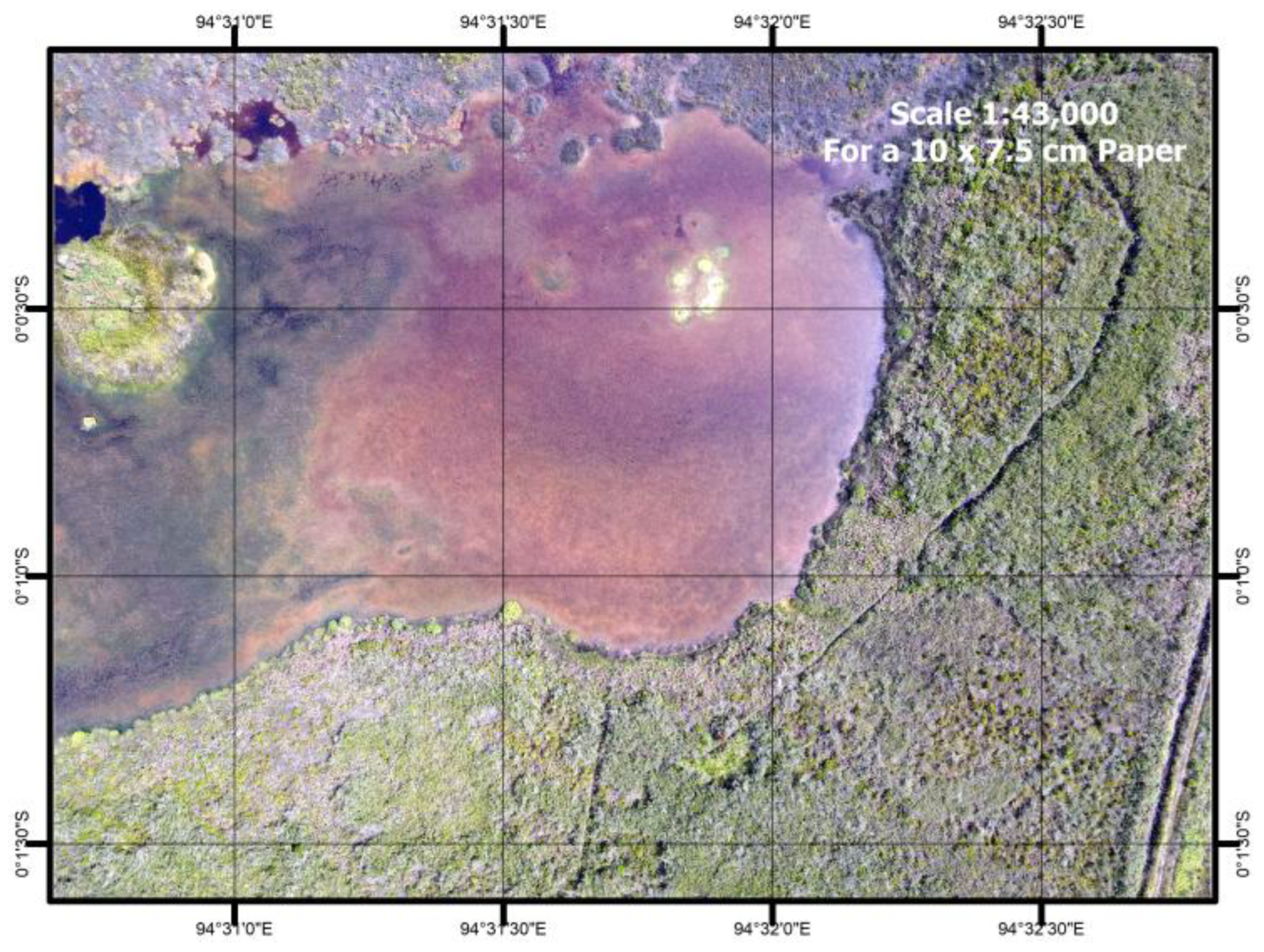
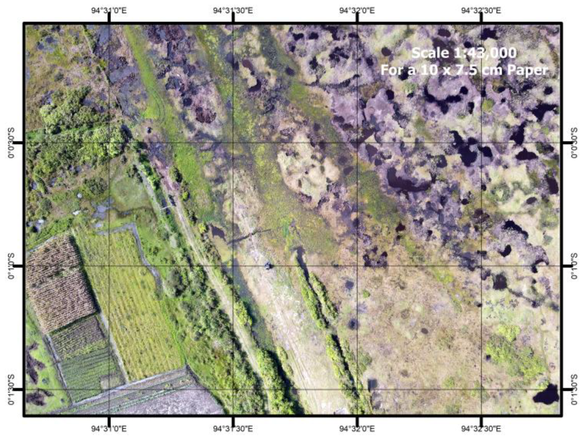
Figure 2 shows drone imagery of an open area that has been cleared (no vegetation) surrounded by bushes in Pollung. In contrast, Figure 3 depicts the conversion of open peatland into cultivated fields in Dolok Sanggul, highlighting the impact of agricultural expansion on the peat landscape. Figure 4 presents the process of soil sampling using a stainless steel auger in cultivated land at Lintong Nihuta, demonstrating how composite peat samples were collected from multiple points to represent site conditions.

3. Results

3.1. Distribution Patterns of C, N, pH, and Soil Respiration

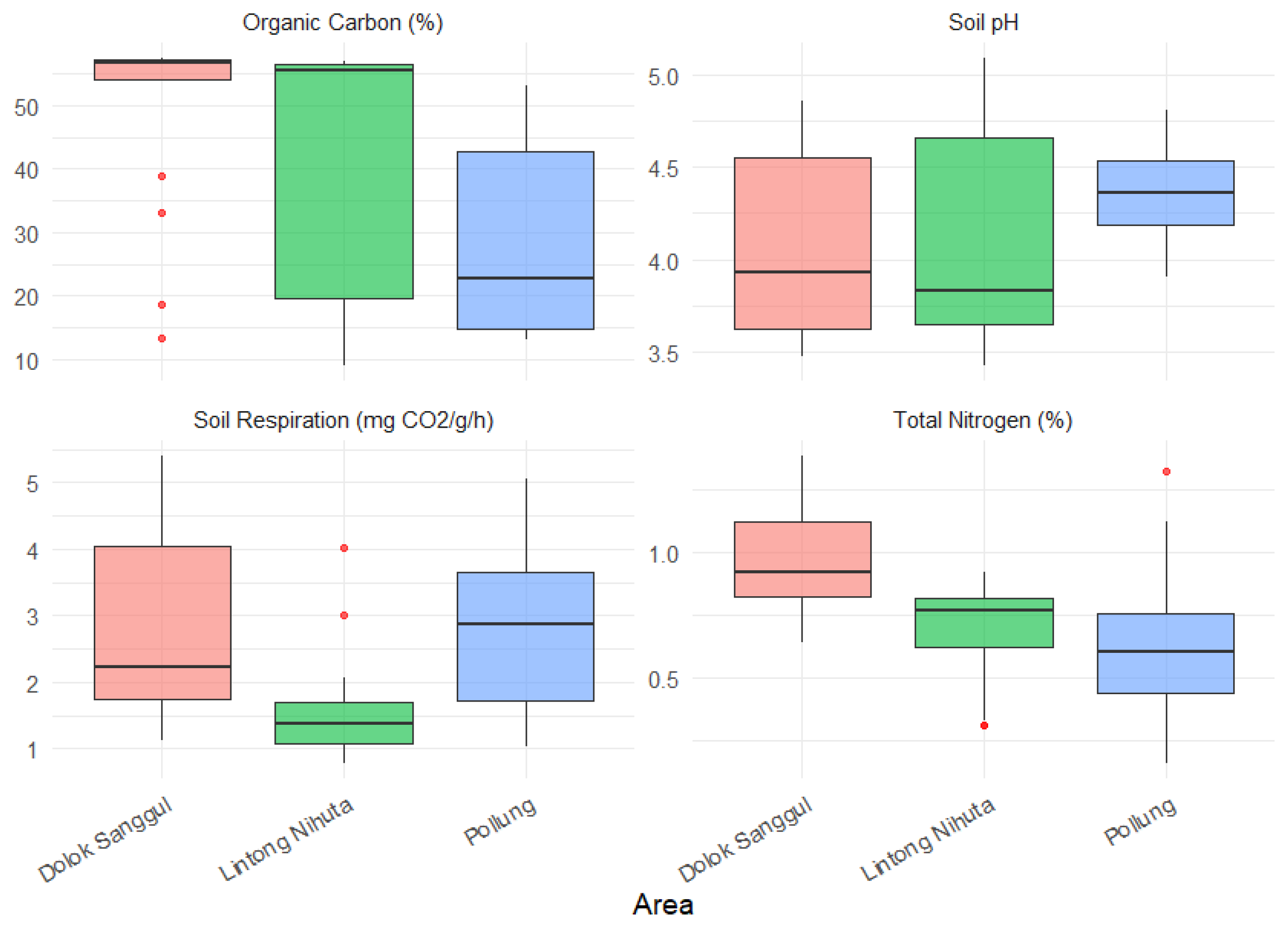
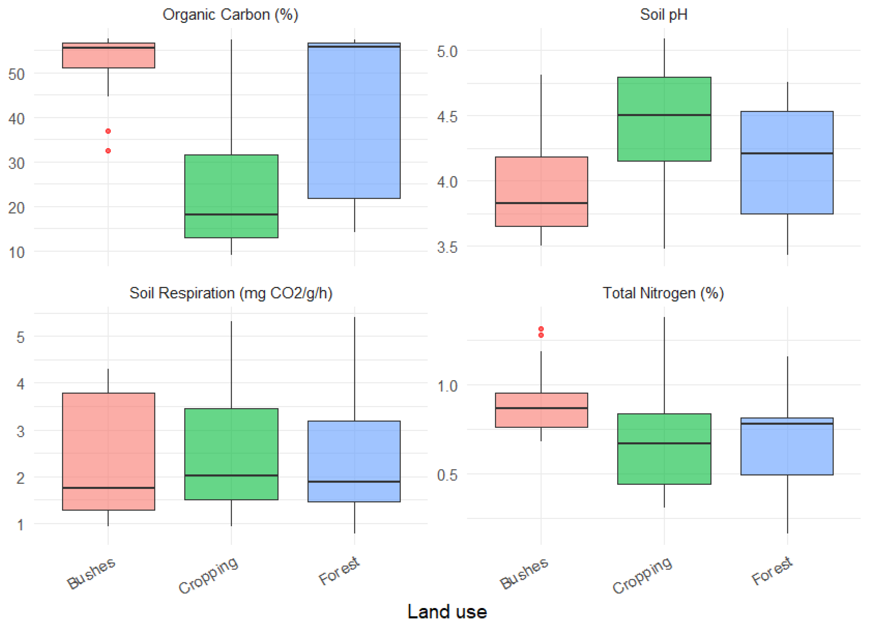
The soil chemical parameters were analysed to identify differences and similarities in soil characteristics across the three observation areas. Figure 5 and Figure 6 show the data distribution of organic carbon (OC) (%), total nitrogen (TN) (%), pH, and soil respiration rate (mg CO2/day), on the three areas (Dolok Sanggul, Lintong Nihuta, and Pollung) and three types of land cover (open land, cultivated land, and natural forest). The data were visualised using boxplots to show the median, quartiles, and distribution of values for each parameter.
There were significant spatial variations in OC content across the sites, as illustrated in Figure 5. Dolok Sanggul maintained the highest OC (>50%), reflecting the role of intact forest cover and waterlogged conditions that reduce decomposition. Pollung exhibited intermediate values (30–45%), which can be attributed to historical mineral soil incorporation by farmers to improve soil workability, leading to dilution of organic matter and enhanced decomposition. In contrast, Lintong Nihuta showed the lowest OC values (10–15%), consistent with intensive cropping systems that reduce organic inputs and increase oxidation rates. This gradient reflects a combination of natural biogeographic factors and human influence that supported Don et al.’s [19] observations on land use impacts. The actual soil OC stocks in the landscapes with long histories of human modification may not be accurately reflected by official peatland map. Traditional farming practices can create mineral-peat soils with distinct biogeochemical properties, as demonstrated in Pollung.
For total N, the three locations had a relatively similar range, namely between 0.4% and 1.2%. Although Dolok Sanggul tended to have slightly higher N content, there were generally no significant differences between locations, indicating that soil N content was relatively stable despite variations in OC content.
Acidic pH values (4–5), typical of tropical peatlands, were observed in all three locations, with slightly higher pH levels in Pollung compared to Dolok Sanggul and Lintong Nihuta. Stronger acidity was maintained in Dolok Sanggul due to its undisturbed condition. In contrast, more intensive cultivation without mineral amendments was practiced in Lintong Nihuta, resulting in maintained acidity despite agricultural use. The pH elevation in Pollung is attributed to two primary factors that align with previous findings about mineral soil incorporation in this area. First, base cations (Ca2+, Mg2+, K+) were introduced through the addition of mineral substrates from surrounding volcanic parent materials, partially neutralising the natural acidity of peat. Second, pH moderation was further contributed to by traditional agricultural practices in Pollung, including occasional liming and the use of ash-rich organic amendments.
The lower soil respiration rates in Lintong Nihuta were primarily caused by intensive agricultural management practices that have altered the natural peat soil conditions. Compared to Dolok Sanggul and Pollung, reduced microbial activity was observed in Lintong Nihuta, with respiration values consistently measuring below 2 mg CO2 per day. This phenomenon can be attributed to several factors. First, significant depletion of organic carbon content was noted due to long-term cultivation, limiting the substrate availability for microbial decomposition. Second, the natural hydrological regime was disrupted by drainage systems implemented for agricultural purposes, affecting moisture-dependent microbial processes. Additionally, fluctuations in rainfall amount and its uneven distribution during the growing season may further exacerbate moisture limitations, thereby constraining microbial activity and soil respiration.
The relationship between organic carbon content and microbial respiration has been extensively documented in peatland ecosystems, with higher carbon stocks typically supporting greater biological activity. In Lintong Nihuta, the combination of carbon loss and physical disturbance resulted in suppressed microbial activities. The respiration patterns suggest changes in microbial community composition, though this would require further metagenomic analysis for confirmation. The observed differences in respiration rates between sites suggest anthropogenic modifications can significantly alter belowground ecological processes in tropical peatlands, even within similar climatic conditions.
Based on Figure 6, a comparison of three types of land use—bushland, cropland, and forest—showed significant differences in the measured soil parameters. The highest OC content was consistently found in forestland, with a wide range reaching more than 50%. Cropland had the lowest OC content, which could be attributed to the intense land cultivation and harvesting practices that contributed to the decline in soil organic matter. This is in line with global meta-analysis [20], which showed that land use changes from forest to cropland caused a significant decrease in soil carbon stocks.
The total N content exhibits a relatively similar pattern, with forest land generally having higher nitrogen content than shrubland and agricultural land. In terms of soil pH, all land uses tend to be acidic, ranging from 4 to 5. In terms of soil respiration rate, forest land showed the highest and most varied microbial respiration activity, indicating high soil biological activity in decomposing organic matter. Shrubland also showed a fairly active respiration rate, while agricultural land showed the lowest respiration activity. This may indicate that microbial activity in agricultural land tends to decrease, possibly due to low organic matter input or disruption of the soil microbial ecosystem [21].

3.2. The Influence of Area, Land Use, and Their Interaction on Soil Parameters

ANOVA analysis was conducted to determine the effect of differences in location (area), land use type, and the interaction between the two on soil parameters. This test aimed to identify whether location and land use factors significantly influence soil chemical and biological conditions, while also examining potential interactions between the two factors.
Table 4 shows the soil chemical (pH, OC, and TN) and biological (respiration) properties at two depths (10 cm and 40 cm) across different sampling sites in the highland peatlands of Humbang Hasundutan. Values presented as mean ± standard deviation (n = 3). Different lowercase letters within the same column indicate statistically significant differences among groups based on Tukey’s HSD test at p < 0.05. For respiration, significant differences were observed across areas, but no significant differences were found among land use types.
OC content varied markedly across sites and land uses, with Dolok Sanggul’s intact peat forest containing 50.6 ± 12.4% OC at 10 cm depth, more than twice the content observed in Lintong Nihuta’s cultivated peat (23.6 ± 14.3%). These differences are consistent with global and regional evidence of substantial carbon loss following forest clearance and drainage [20]. Vertical stratification was pronounced, with surface layers consistently richer in organic matter, mirroring depth trends in both highland and lowland peat systems.
TN patterns were similar to carbon, ranging from 0.6% in cultivated and disturbed sites to 1.0% in forest and shrub soils. C:N ratio amongst the three sites is consistent between 50 in Polung to 57 in Lintong Nihuta. Vegetation type emerged as a key control through differences in litter C:N ratio, with the highest value in forest (C:N = 66), followed by bushes (C:N = 59) and cropping (C:N = 34) [21,22]. The particularly low N under conifers likely reflects both biochemical inhibition of decomposition and the absence of N-fixing associations. These findings extend lowland peat research by suggesting elevation-dependent nitrogen retention and by highlighting sapric peat–mineral interfaces as potential geogenic N sources. Conversely, Lintong Nihuta’s agricultural peats exhibit the clearest depletion, a condition exacerbated by low-input, unrotated polyculture and the absence of targeted fertilisation.
In the Humbang Hasundutan peatlands, the dynamics of organic carbon and nitrogen are closely linked to vegetation cover and hydrological status. Surface litter and root inputs are the primary sources of soil organic matter, and their stability depends on how waterlogging and land use influence decomposition processes. As shown in Table 5, OC emerged as the main predictor of TN, with land use—particularly cropping—significantly modifying this relationship. TN is related to OC and land use with a linear model (R2 = 0.56, p < 0.0001). The linear relationship between OC and TN was modified by land use. The slope for OC (0.012, p < 0.0001) indicates the coupling of OC and TN in peat systems in forest soils, which maintain a high C/N ratio (mean = 66). Land use modifies this relationship: bushes soils maintain a relationship similar from forests, suggesting resilience of C–N coupling under moderate disturbance. While croplands contain significantly higher TN at a given OC level (0.109%, p = 0.025), this is likely due to external N inputs, such as fertilisers or ash.
Soil pH remained acidic throughout (3.4–5.1), with slightly higher values in cultivated and mineral-influenced sites. This aligns with expectations that base cation inputs from mineral soil, liming, or ash can partially buffer peat acidity [23,24]. Nevertheless, these pH increases are modest and may carry trade-offs, as peat acidity is tightly linked to organic matter preservation.
Microbial respiration exhibited the highest mean activity in undisturbed Dolok Sanggul forests (3.1 ± 0.6 mg CO2 day−1), whereas the lowest levels were recorded in disturbed Juncus-dominated sites, highlighting the sensitivity of peatland microbial processes to land use disturbance. Although variability at Dolok Sanggul 40 cm depth was captured within the mean and standard deviation, land use alone did not significantly influence respiration. Instead, hydro-edaphic factors such as water table depth, oxygen status, and peat decomposition stage emerged as stronger determinants [25]. Elevated respiration in fern–Tibouchina forests reflects continuous litter inputs, root exudates, and stable microclimates, whereas phenolic-rich, high C:N litter in Juncus sites suppresses microbial activity. Notably, highland peatlands sustain baseline respiration rates that are 2–3 times higher than those of lowland plantations, indicating that cooler temperatures may buffer oxidative losses and that restored hydrology could enhance microbial recovery. According to Henry’s law, the solubility of a gas decreases with increasing temperature, which may explain why cooler highland conditions favour higher dissolved oxygen availability and support more stable microbial respiration [26,27].

3.3. Principal Component Analysis (PCA) of Peat Soil Quality Parameters

The Principal Component Analysis (PCA) of peat soil characteristics in Humbang Hasundutan highlands revealed two dominant dimensions of variation, collectively explaining 81.34% of total variance (Table 6). The first component (PC1), accounting for 42.58% of variance, captured the fundamental biogeochemical axis of peat soils, with strong positive loadings for OC (0.937) and TN (0.803), and a negative loading for pH (−0.774). This pattern reflects the well-established relationship between organic matter accumulation and acidification in waterlogged peat systems, where anaerobic conditions preserve nitrogen content while promoting the formation of organic acids [2]. The inverse correlation between pH and C/N in PC1 highlights how natural peat formation processes create chemically distinct environments compared to mineral soils.
PC2 represented a distinct biological dimension (38.76% variance), associated with soil respiration measurements (loadings > 0.98). The near-perfect alignment of respiration replicates in PC2 not only confirms methodological reliability but also highlights microbial activity as a key independent driver of peatland functioning. The orthogonal orientation of PC1 and PC2 vectors in the biplot space (Figure 7) demonstrates that chemical and biological properties respond to different environmental controls.
Land use types showed clear differentiation in the PCA space. While agricultural areas exhibited elevated PC1 scores (reflecting modified chemical properties through mineral soil mixing), they had reduced PC2 values, indicating suppressed biological activity. Natural forest sites showed the inverse pattern, maintaining robust microbial respiration (PC2) despite lower nutrient availability (PC1). This divergence suggests that cultivation practices disrupt the coupling between peat chemistry and biology that characterises intact systems [28]. The stability of the PCA solution (varimax rotation convergence in 3 iterations; communalities >0.6 for all parameters except pH at 0.602) supports the robustness of these patterns.

4. Discussion

The Humbang (Toba highland) peatlands formed on the southern flank of the Toba caldera after the super-eruption ca. 74,000 years ago, blanketing the landscape with the Youngest Toba Tuff. Depressions, small basins, and extinct volcanic craters at elevations of ~1300–1450 m became persistently waterlogged in the region’s cool, wet climate, allowing organic matter to accumulate. The peat is predominantly woody, derived from long-standing forest cover, with Sphagnum increasingly common above ~1200 m in marshy and infilling sites. Historical cores indicate local thicknesses up to ~10 m (now commonly 1–3 m where degraded), with an estimate of millennia of slow vertical growth at ~0.1–0.6 mm yr−1 (≈0.1–0.4 Mg C ha−1 yr−1) [11,26].
Radiocarbon ages indicate a late Pleistocene origin: basal layers in several sites date to ~20,000–30,000 years BP [29], with some crater-fill peats dating to around 12,000 years BP [30]. These highland peats are therefore far older than many Indonesian coastal peatlands, which initiated after Holocene sea-level stabilisation (typically ≤6.5 ka BP) [31]. Human influence is evident in the late Holocene, with forest clearance apparent from ~7.5 ka and rice cultivation from ~2–2.6 ka, which altered vegetation trajectories but did not alter the fundamentally Pleistocene origins of these ancient peat deposits [30].
In the high-altitude peatland (>1500 m.a.s.l.) review by Gaffney et al. [8], the authors noted that the vegetation was mostly fens, typically sedge- or Sphagnum-dominated. Core ages across high-altitude peatlands span from 180 years to over 15 ka BP, with Andean sites generally being younger (2.5–10.9 ka BP), Tibetan Plateau sites (9–15.5 ka BP), and NE China sites (~1.2–8.4 ka BP). The C accumulation rate is 0.11 to 0.47 Mg C ha−1 yr−1 with a recent rate of 0.4 to 40 Mg C ha−1 yr−1. This shows that the peatland in Humbang Hasunduatan was older with a similar long-term accumulation rate.
Against global synthesis, the data in Humbang Hasundutan align with global peatland chemistry gradients. Globally, depth effects are small: OM declines with depth by <5%, while median peat C stays around 44–46% C. Median N across all peatlands is 1.5% with C:N ratio of 27–32, with higher N (lower C:N) in minerotrophic systems [32]. In that context, Lintong Nihuta and Dolok Sanggul (OC ≈ 55–57%, pH ≈ 3.8–3.9) resemble the most acidic, carbon-rich endmembers (ombrotrophic/bog-like), but are more N-limited than the global median (C:N ≳ 50 vs. 30), consistent with very low N concentrations relative to C. The C:N ratio of forests in Humbang Hasundutan (66.5 ± 21.0) is between sphagnum (81.0 ± 49.2) and woody (45.3 ± 19.1) in the northern peatland, while cropping lands (34.6 ± 12.7) are aligned with humified peats (36.0 ± 17.6) [33]. Pollung (lower median OC ~23%, higher pH ~4.4, lower C:N ~38) aligns with a more oxidised state, akin to the lower-C end (intermediate/humified range), and its higher respiration fits global expectations that less acidic, more mineral-influenced or drained peats show greater decomposability.
Although the lower respiratory rate observed in cultivated peatlands is primarily attributed to carbon substrate depletion, other factors may also contribute to this pattern. Agricultural management practices, such as repeated tillage, fertiliser use, and pesticide application, can alter soil structure and microbial habitat, thereby reducing microbial activity [34]. In addition, nutrient limitations, particularly N and P, are known to constrain microbial metabolism and respiration in peat soils [35]. The simplification of vegetation structure under monoculture cultivation compared to forest ecosystems may further reduce microbial diversity, leading to a less efficient decomposition community [36].
When conducting global comparisons, it is essential to emphasise the influence of the study area’s unique characteristics and environmental conditions. Unlike Indonesia’s lowland peatlands, the highland peats of Humbang Hasundutan are characterised by a cooler climate (mean 18–24 °C) and high annual rainfall (~2300 mm). These climatic conditions, combined with the fragmented geomorphology of peat deposits formed on volcanic substrates and rapid fluctuations in the water table, regulate peat decomposition and microbial activity differently from those in lowland systems. However, the vegetation that contributes to Humbang Hasundutan peatlands is characterised by woody plants, which generally have lower carbon storage capacity due to their shallower depth, higher bulk density, and high C:N ratios. But their cooler climate and higher rainfall may stabilise microbial activity and slow decomposition. In contrast, lowland peatlands in Sumatra and Kalimantan typically formed after the Holocene sea-level rise and are deeper, store larger carbon stocks, and have lower bulk density; however, they are more vulnerable to subsidence and rapid carbon loss when drained. Differences are also evident in nutrient cycling and microbial dynamics: highland systems tend to be more nitrogen-limited and support distinct microbial respiration patterns, while lowland peat under drainage exhibits higher respiration rates and accelerated nutrient turnover. Regionally, we compared our results with those from Samosir and other highland peat basins in North Sumatra, which also exhibited shallow deposits and strong mineral admixture due to long-term agricultural use [7,15]. This supports our observation that Pollung’s peat soils have relatively low carbon content because of historical mixing with mineral soil. Highland peats, although smaller in extent, remain highly significant for climate mitigation and demand conservation strategies tailored to their unique vulnerabilities.
Our data indicate that Humbang Hasundutan’s peatlands have been heavily degraded since they were reported in the 1990s [29], with marked differences in C and N stocks. In relatively undisturbed systems such as Dolok Sanggul, continuous litter input from forest vegetation and minimal disturbance under waterlogged conditions, reduced decomposition and maintained C (49.8%) and N (0.96%). This mirrors patterns observed in other Indonesian peat forests [37] and confirms the role of vegetation structure, hydrology, and organic matter inputs in maintaining peat’s carbon sequestration function [38].
Peatlands in Pollung show the lowest OC (mean 28%), with areas under forest cover having a mean OC of 18%. Cropping systems exhibit the strongest depletion signal (≈24% OC), which aligns with global reviews that report substantial carbon losses following the conversion of forest to agriculture through drainage, tillage, and reduced organic inputs [15]. Nitrogen mirrors these patterns (≈0.6–1.0%), reflecting litter quality and turnover, forested and shrub sites accumulate more N via sustained organic matter cycling, whereas cultivated sites lack comparable inputs and often operate with low-input nutrient regimes. The activity of diazotrophic fungi and bacteria that fix atmospheric nitrogen, including methanotrophs and rhizospheric microbes, may contribute additional biological N inputs in peat soils [39,40,41].
Our study emphasises the effect of human disturbance, primarily intensive land use and artificial drainage, which has strong negative effects on high-altitude peatland carbon cycling, reducing soil organic carbon stocks, increasing respiration and bulk density, and altering methane emissions [8].
Soil pH patterns further demonstrate the impact of human management. While acidic conditions typical of tropical peat (pH 3.9–4.4) persist, agricultural plots reached pH values as high as 5.09, likely due to liming, ash inputs, or base cation enrichment from mineral material. Although such interventions can temporarily improve nutrient availability, they may also risk accelerating decomposition if not carefully managed, especially in peat systems where acidity acts as a natural carbon preservation mechanism.
While the data indicate substantial C depletion in cultivated areas, the absence of bulk density (BD) measurements in this study prevents accurate estimation of carbon stocks [36,37]. Previous studies in tropical peatlands of Kalimantan and Sumatra report BD values ranging between 0.07 and 0.30 g cm−3, with higher values generally observed in degraded or cultivated sites due to compaction and loss of organic matter [42]. Future studies should therefore integrate bulk density alongside chemical and biological indicators to provide a more complete understanding of carbon dynamics in tropical highland peatlands.
Microbial respiration patterns revealed that area effects outweighed land use effects (F = 7.32; p = 0.002). Areas under forests sustain higher microbial biomass and respiration through steady litter inputs and root exudation even under acidic, nutrient-poor conditions [22]. Long-term cultivation at Lintong Nihuta has depleted labile substrates and altered microbial communities.
C strongly predicts TN, showing that these elements are naturally coupled through litter input and slow decomposition. Forest and bushland soils maintain this balance, but croplands display elevated N relative to C, due to external inputs. This shift highlights how agricultural practices disrupt peatland nutrient dynamics, enhancing short-term fertility but increasing long-term risks of carbon loss and nitrogen leaching. The depletion of C and N in cultivated peatlands, particularly in Lintong Nihuta, indicates a trajectory toward declining environmental health, increased chemical input dependency, enhanced decomposition and greenhouse gas emissions, and long-term land degradation. These results corroborate broader critiques of conventional tropical peat agriculture [23].
At the national and global scale, the high carbon stocks and nutrient retention in Dolok Sanggul’s intact peat forests highlight their value for climate mitigation and biodiversity conservation. Protecting such sites directly supports Indonesia’s Nationally Determined Contributions (NDCs) under the Paris Agreement and advances SDG 15 (Life on Land). For degraded peatlands, restoration strategies must prioritise rewetting to raise water tables and re-establish anaerobic conditions, coupled with revegetation using native peat-adapted species. Successful models exist in Indonesia [43], but our findings indicate that highland-specific hydrology and vegetation dynamics warrant tailored restoration protocols. The weak direct influence of current land use on respiration suggests that, if hydrology is restored, microbial function, and by extension, decomposition–sequestration balance, could rebound. Active rehydration measures, such as canal blocking and water retention, should be prioritised in rehabilitation protocols to ensure the effectiveness of peatland restoration [37,38].
For highland peatlands, restoration must consider their shallow depth, steeper topography, and volcanic basin setting, which make large-scale rewetting more challenging than in lowland systems. Instead, site-specific measures such as maintaining natural water retention in small catchments, conserving remnant native vegetation, and adopting highland-adapted agroforestry systems (e.g., shade-grown coffee, mixed horticulture with tree cover) are recommended. These tailored approaches complement national strategies (e.g., peat restoration framework) by addressing the unique hydrological and ecological characteristics of high-altitude peat ecosystems [44].
For agricultural peatlands, innovations in agroecology such as cover cropping, selecting appropriate crops and strategic liming offer pathways to balance productivity with long-term soil health. Given the observed pH moderation in cultivated areas, carefully calibrated amendments could reduce acidity without compromising carbon stability, though such interventions require monitoring of both chemical and biological indicators to avoid unintended acceleration of peat mineralisation [45].
This study captures clear spatial and land use signals; however, there are still limitations, as it is a snapshot of the current condition. This study is based on a single field campaign conducted in February 2024, coinciding with the wet season. Digital soil mapping is required to capture the spatial distribution of the peats [34,35,36]. Water-table depth and redox profiles are needed to mechanistically link respiration to moisture–oxygen dynamics [46]. Soil microbial measurement via metagenomics would provide a clearer understanding of microbial distribution. Future work will monitor water level, peat physical properties (fibre content, degree of humification), DOC/phenolics, and gas fluxes (including CH4) that represent the temporal variability and enable stronger guidance for restoration targets [47].

5. Conclusions

This study systematically evaluated the impact of land use changes on the chemical and biological properties of highland peat soils in Humbang Hasundutan, Indonesia, focusing on natural forest, open land, and cultivated land systems. The results demonstrate that forested peatlands, particularly in Dolok Sanggul, maintained significantly higher organic carbon content (57.30% at 10 cm depth) compared to degraded agricultural sites in Lintong Nihuta (10–15%), with ANOVA confirming strong effects of both geographic area (F = 31.95, p < 0.001) and land use type (F = 56.07, p < 0.001). Nitrogen dynamics followed similar patterns, with undisturbed forests retaining nearly double the nitrogen content (1.16%) of cultivated areas, supported by significant area (F = 18.09) and land use (F = 10.19) effects. Microbial respiration showed area-dependent patterns, with the highest activity in forests (5.49 mg CO2/day), but remained resilient to land use changes. These findings provide the first empirical evidence of how highland peat properties respond to anthropogenic conversion, establishing critical baselines for their conservation in climate mitigation strategies while highlighting the unique biogeochemical dynamics that distinguish them from lowland peat systems.
Highland peats represent both a conservation priority and a scientific frontier. Their combination of high carbon and nitrogen stocks, distinctive microbial dynamics, and susceptibility to human disturbance underscores the need to integrate them explicitly into Indonesia’s peatland management frameworks. There is an opportunity to safeguard these ecosystems in ways that support both local livelihoods and global climate goals. A comprehensive peatland management framework should integrate sustainable agriculture, forestry, and agroforestry practices to ensure long-term resilience.

Author Contributions

Conceptualization, S.P.M. and S.T.; methodology, S.P.M., R. and B.M.; data collection, S.P.M.; data analysis, S.P.M.; data interpretation, S.P.M., R. and B.M.; writing—original draft preparation, S.P.M.; writing—review and editing, S.P.M., S.T., R. and B.M. All authors have read and agreed to the published version of the manuscript.

Funding

This article is the output of research project entitled “Model Perubahan Tutupan Lahan Gambut Terhadap Kualitas Lahan Gambut di Kabupaten Humbang Hasundutan” which receive funding from “Directorate general of higher education, research and technology, Ministry of Education, Culture, Research and Technology” for funding this research in the 2024 fiscal year (contract number: 63/UN5.4.10.S/PPM/KP-DRTPM/2024).

Data Availability Statement

The original contributions presented in this study are included in the article. Further inquiries can be directed to the corresponding author.

Conflicts of Interest

The authors declare no conflicts of interest.

References

  1. Omar, M.S.; Ifandi, E.; Sukri, R.S.; Kalaitzidis, S.; Christanis, K.; Lai, D.T.C.; Bashir, S.; Tsikouras, B. Peatlands in Southeast Asia: A Comprehensive Geological Review. Earth-Sci. Rev. 2022, 232, 104149. [Google Scholar] [CrossRef]
  2. Leifeld, J.; Menichetti, L. The Underappreciated Potential of Peatlands in Global Climate Change Mitigation Strategies. Nat. Commun. 2018, 9, 1071. [Google Scholar] [CrossRef]
  3. Minasny, B.; Adetsu, D.V.; Aitkenhead, M.; Artz, R.R.E.; Baggaley, N.; Barthelmes, A.; Beucher, A.; Caron, J.; Conchedda, G.; Connolly, J.; et al. Mapping and Monitoring Peatland Conditions from Global to Field Scale. Biogeochemistry 2024, 167, 383–425. [Google Scholar] [CrossRef]
  4. Anda, M.; Ritung, S.; Suryani, E.; Sukarman; Hikmat, M.; Yatno, E.; Mulyani, A.; Subandiono, R.E.; Suratman; Husnain. Revisiting Tropical Peatlands in Indonesia: Semi-Detailed Mapping, Extent and Depth Distribution Assessment. Geoderma 2021, 402, 115235. [Google Scholar] [CrossRef]
  5. Pacheco-Cancino, P.A.; Carrillo-López, R.F.; Sepulveda-Jauregui, A.; Somos-Valenzuela, M.A. Sphagnum Mosses, the Impact of Disturbances and Anthropogenic Management Actions on Their Ecological Role in CO2 Fluxes Generated in Peatland Ecosystems. Glob. Chang. Biol. 2024, 30, e16972. [Google Scholar] [CrossRef] [PubMed]
  6. Laiho, R. Decomposition in Peatlands: Reconciling Seemingly Contrasting Results on the Impacts of Lowered Water Levels. Soil Biol. Biochem. 2006, 38, 2011–2024. [Google Scholar] [CrossRef]
  7. Munawaroh, H.; Rauf, A.; Razali; Bintang; Sabrina, T. Preliminary Study on C-Organic and C-Microbial Biomass of Peatland in Toba Highlands. IOP Conf. Ser. Earth Environ. Sci. 2022, 1025, 012017. [Google Scholar] [CrossRef]
  8. Gaffney, P.P.J.; Tang, Q.; Wang, J.; Zhang, C.; Xu, X.; Xu, X.; Li, Y.; Pap, S.; Ratcliffe, J.L.; Li, Q.; et al. The High-Altitude Peatland Carbon Cycle: A Review of the Impacts of Climate and Land-Use Change. Geogr. Sustain. 2025, 6, 100353. [Google Scholar] [CrossRef]
  9. Polak, E. Ueber Torf Und Moor in Niederländisch Indien; North-Holland Publishing Company: Amsterdam, The Netherlands, 1933; Volume 30, Available online: https://cir.nii.ac.jp/crid/1971430859825830460.
  10. Maloney, B.K. Pollen Analytical Evidence for Early Forest Clearance in North Sumatra. Nature 1980, 287, 324–326. [Google Scholar] [CrossRef]
  11. Minasny, B.; Sabrina, T.; Akoeb, E.N. Toba Highland Peatlands: Exploring a Unique Ecosystem and Its Environmental Significance. J. Smart Agric. Environ. Technol. 2023, 1, 66–72. [Google Scholar] [CrossRef]
  12. Sinurat, P.T.; Munibah, K.; Baskoro, D.P.T. Modeling Land-Use Change in Humbang Hasundutan District Using Clue-S. J. Ilmu Tanah Dan Lingkung. 2015, 17, 75–82. [Google Scholar] [CrossRef]
  13. Taufik, M.; Minasny, B.; Mcbratney, A.B.; Van Dam, J.C.; Jones, P.D.; Van Lanen, H.A.J. Human-Induced Changes in Indonesian Peatlands Increase Drought Severity. Environ. Res. Lett. 2020, 15, 084013. [Google Scholar] [CrossRef]
  14. Murdiyarso, D.; Lilleskov, E.; Kolka, R. Tropical Peatlands under Siege: The Need for Evidence-Based Policies and Strategies. Mitig. Adapt. Strateg. Glob. Chang. 2019, 24, 493–505. [Google Scholar] [CrossRef]
  15. Fiantis, D.; Rudiyanto; Ginting, F.I.; Agtalarik, A.; Arianto, D.T.; Wichaksono, P.; Irfan, R.; Nelson, M.; Gusnidar, G.; Jeon, S.; et al. Mapping Peat Thickness and Carbon Stock of a Degraded Peatland in West Sumatra, Indonesia. Soil Use Manag. 2024, 40, e12954. [Google Scholar] [CrossRef]
  16. Qin, L.; Freeman, C.; Jia, X.; Zhang, Z.; Liu, B.; Zhang, S.; Jiang, M. Microbial Enzyme Activity and Stoichiometry Signal the Effects of Agricultural Intervention on Nutrient Cycling in Peatlands. Ecol. Indic. 2021, 122, 107242. [Google Scholar] [CrossRef]
  17. Savichev, O.; Soldatova, E.; Rudmin, M.; Mazurov, A. Geochemical Barriers in Oligotrophic Peat Bog (Western Siberia). Appl. Geochem. 2020, 113, 104519. [Google Scholar] [CrossRef]
  18. Widati, S. Soil Biology Analysis Methods; Center for Agricultural Land Resources Research and Development: Bogor, Indonesia, 2007. [Google Scholar]
  19. Don, A.; Schumacher, J.; Freibauer, A. Impact of Tropical Land-use Change on Soil Organic Carbon Stocks—A Meta-analysis. Glob. Chang. Biol. 2011, 17, 1658–1670. [Google Scholar] [CrossRef]
  20. Guo, L.B.; Gifford, R.M. Soil Carbon Stocks and Land Use Change: A Meta Analysis. Glob. Chang. Biol. 2002, 8, 345–360. [Google Scholar] [CrossRef]
  21. Raich, J.W.; Schlesinger, W.H. The Global Carbon Dioxide Flux in Soil Respiration and Its Relationship to Vegetation and Climate. Tellus B Chem. Phys. Meteorol. 1992, 44, 81–99. [Google Scholar] [CrossRef]
  22. Wardle, D.A. Communities and Ecosystems: Linking the Aboveground and Belowground Components (MPB-34); Princeton University Press: Princeton, NJ, USA, 2013. [Google Scholar]
  23. Hättenschwiler, S.; Vitousek, P.M. The Role of Polyphenols in Terrestrial Ecosystem Nutrient Cycling. Trends Ecol. Evol. 2000, 15, 238–243. [Google Scholar] [CrossRef] [PubMed]
  24. Berg, B.; McClaugherty, C. Plant Litter: Decomposition, Humus Formation, Carbon Sequestration; Springer: Berlin/Heidelberg, Germany, 2008. [Google Scholar]
  25. Fang, C.; Moncrieff, J.B. The Variation of Soil Microbial Respiration with Depth in Relation to Soil Carbon Composition. Plant Soil 2005, 268, 243–253. [Google Scholar] [CrossRef]
  26. Henry, W. Experiments on the Quantity of Gases Absorbed by Water, at Different Temperatures, and under Different Pressures. Philos. Trans. R. Soc. Lond. 1802, 93, 29–274. [Google Scholar]
  27. de Paula, J. Atkins’ Physical Chemistry; Oxford University Press: Oxford, UK, 2010. [Google Scholar]
  28. Hergoualc’h, K.; Verchot, L.V. Stocks and Fluxes of Carbon Associated with Land Use Change in Southeast Asian Tropical Peatlands: A Review. Glob. Biogeochem. Cycles 2011, 25, GB2001. [Google Scholar] [CrossRef]
  29. Maloney, B.K.; McCormac, F.G. Palaeoenvironments of North Sumatra: A 30,000 Year Old Pollen Record from Pea Bullok. Bull. Indo-Pac. Prehistory Assoc. 1996, 14, 73–82. [Google Scholar] [CrossRef]
  30. Maloney, B.K. Man’s Impact on the Rainforests of West Malesia: The Palynological Record. J. Biogeogr. 1985, 12, 537–558. [Google Scholar] [CrossRef]
  31. Ruwaimana, M.; Anshari, G.Z.; Silva, L.C.R.; Gavin, D.G. The Oldest Extant Tropical Peatland in the World: A Major Carbon Reservoir for at Least 47 000 Years. Environ. Res. Lett. 2020, 15, 114027. [Google Scholar] [CrossRef]
  32. Watmough, S.; Gilbert-Parkes, S.; Basiliko, N.; Lamit, L.J.; Lilleskov, E.A.; Andersen, R.; del Aguila-Pasquel, J.; Artz, R.E.; Benscoter, B.W.; Borken, W.; et al. Variation in Carbon and Nitrogen Concentrations among Peatland Categories at the Global Scale. PLoS ONE 2022, 17, e0275149. [Google Scholar] [CrossRef]
  33. Loisel, J.; Yu, Z.; Beilman, D.W.; Camill, P.; Alm, J.; Amesbury, M.J.; Anderson, D.; Andersson, S.; Bochicchio, C.; Barber, K.; et al. A Database and Synthesis of Northern Peatland Soil Properties and Holocene Carbon and Nitrogen Accumulation. Holocene 2014, 24, 1028–1042. [Google Scholar] [CrossRef]
  34. Lauber, C.L.; Strickland, M.S.; Bradford, M.A.; Fierer, N. The Influence of Soil Properties on the Structure of Bacterial and Fungal Communities across Land-Use Types. Soil Biol. Biochem. 2008, 40, 2407–2415. [Google Scholar] [CrossRef]
  35. Cleveland, C.C.; Liptzin, D. C:N:P Stoichiometry in Soil: Is There a “Redfield Ratio” for the Microbial Biomass? Biogeochemistry 2007, 85, 235–252. [Google Scholar] [CrossRef]
  36. Jangid, K.; Williams, M.A.; Franzluebbers, A.J.; Schmidt, T.M.; Coleman, D.C.; Whitman, W.B. Land-Use History Has a Stronger Impact on Soil Microbial Community Composition than Aboveground Vegetation and Soil Properties. Soil Biol. Biochem. 2011, 43, 2184–2193. [Google Scholar] [CrossRef]
  37. Saleilei, A.A.; Salampak; Yulianti, N.; Adji, F.F.; Damanik, Z.; Giyanto. Study of C-Organic Content, Ash Content, and Bulk Density of Inland Peat in the Special Purpose Forest Area Tumbang Nusa, Central Kalimantan. J. Environ. Sci. 2022, 16, 59–66. [Google Scholar] [CrossRef]
  38. Rudiyanto; Minasny, B.; Setiawan, B.I. Further Results on Comparison of Methods for Quantifying Soil Carbon in Tropical Peats. Geoderma 2016, 269, 108–111. [Google Scholar] [CrossRef]
  39. Lal, R. Soil Carbon Sequestration to Mitigate Climate Change. Geoderma 2004, 123, 1–22. [Google Scholar] [CrossRef]
  40. Robinson, C.H.; Ritson, J.P.; Alderson, D.M.; Malik, A.A.; Griffiths, R.I.; Heinemeyer, A.; Gallego-Sala, A.V.; Quillet, A.; Robroek, B.J.M.; Evans, C.; et al. Aspects of Microbial Communities in Peatland Carbon Cycling under Changing Climate and Land Use Pressures. Mires Peat 2023, 29, 2. [Google Scholar]
  41. Yin, T.; Feng, M.; Qiu, C.; Peng, S. Biological Nitrogen Fixation and Nitrogen Accumulation in Peatlands. Front. Earth Sci. 2022, 10, 670867. [Google Scholar] [CrossRef]
  42. Sinclair, A.L.; Graham, L.L.; Putra, E.I.; Saharjo, B.H.; Applegate, G.; Grover, S.P.; Cochrane, M.A. Effects of Distance from Canal and Degradation History on Peat Bulk Density in a Degraded Tropical Peatland. Sci. Total Environ. 2020, 699, 134199. [Google Scholar] [CrossRef]
  43. Taufik, M.; Haikal, M.; Widyastuti, M.T.; Arif, C.; Santikayasa, I.P. The Impact of Rewetting Peatland on Fire Hazard in Riau, Indonesia. Sustainability 2023, 15, 2169. [Google Scholar] [CrossRef]
  44. Zahro, Q.; Izumi, Y.; Novresiandi, D.A.; Cahyana, D.; Widodo, J.; Ito, D.; Ota, K.; Dong, M. Tropical Peatland Restoration Evaluation Using Time-Series L-Band InSAR Analysis. Sci. Rep. 2025, 15, 23749. [Google Scholar] [CrossRef]
  45. Flood, K.; Wilson, D.; Renou-Wilson, F. Evidence Synthesis and Knowledge Integration for Sustainable Peatland Management. Land 2025, 14, 1397. [Google Scholar] [CrossRef]
  46. Sarifuddin; Sitohang, E.J.; Mukhlis. Characteristics and Classification of the Peat at Toba Highland, North Sumatera, Indonesia. Ilmu Pertan. Agric. Sci. 2024, 9, 35–42. [Google Scholar] [CrossRef]
  47. Murdiyarso, D.; Swails, E.; Hergoualc’h, K.; Bhomia, R.; Sasmito, S.D. Refining Greenhouse Gas Emission Factors for Indonesian Peatlands and Mangroves to Meet Ambitious Climate Targets. Proc. Natl. Acad. Sci. USA 2024, 121, e2307219121. [Google Scholar] [CrossRef] [PubMed]
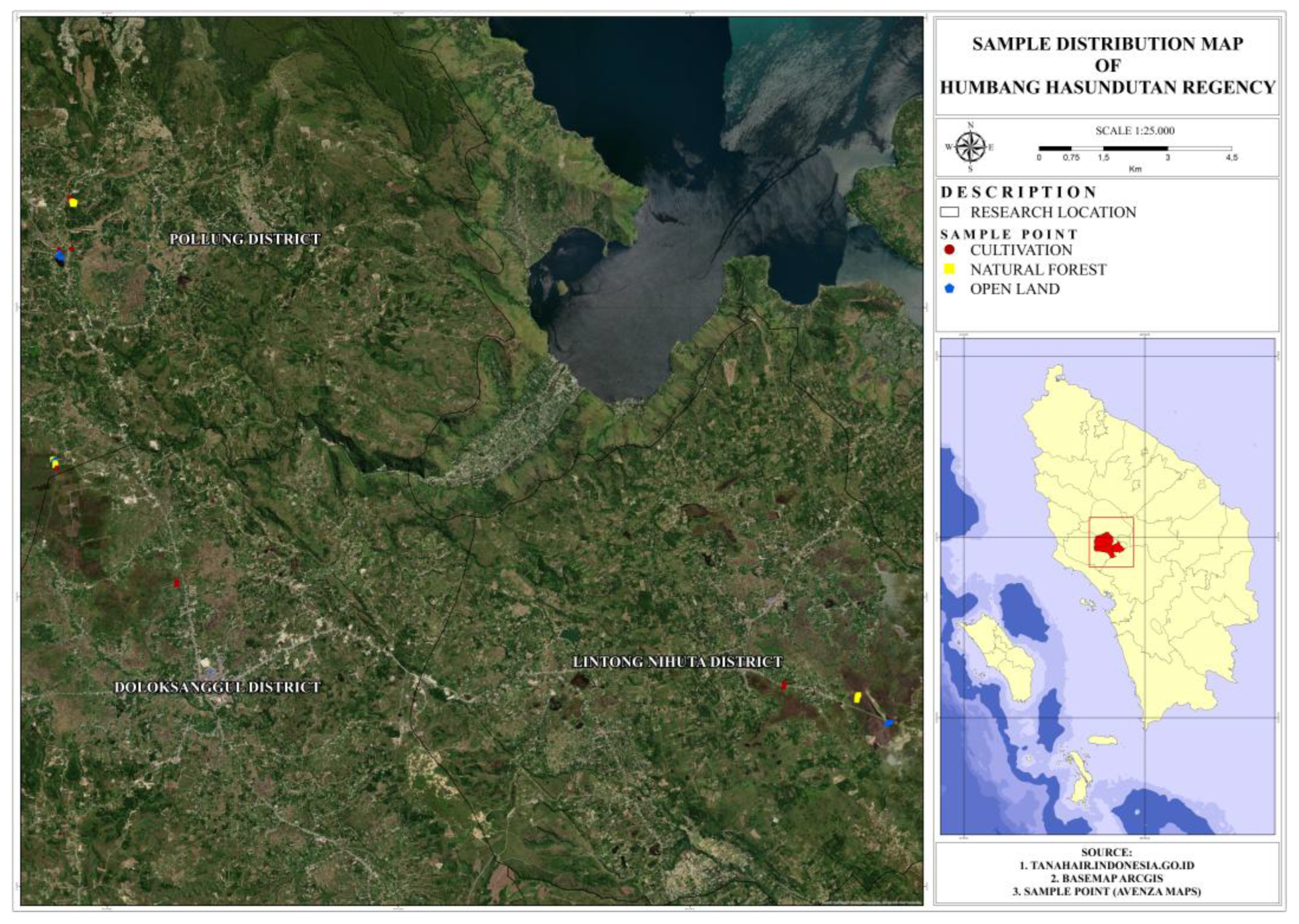
Figure 1. Map of the distribution of sample points in Humbang Hasundutan Regency.
Land 14 02015 g001
Figure 2. Drone imagery of an open area, partly representing marsh-like ecosystems in Pollung, Humbang Hasundutan Regency.
Land 14 02015 g002
Figure 3. Conversion of peatland into cultivated fields in Dolok Sanggul, Humbang Hasundutan Regency.
Land 14 02015 g003
Figure 4. Peat soil sampling using an auger to collect composite samples in cultivated land in Lintong Nihuta, Humbang Hasundutan Regency.
Land 14 02015 g004
Figure 5. Boxplot of soil quality parameter data distribution patterns in three regions, highlighting spatial variations in organic carbon content.
Land 14 02015 g005
Figure 6. Boxplot of soil quality parameter data distribution patterns in three land covers.
Land 14 02015 g006
Figure 7. Principal Component Analysis (PCA) biplot based on rotated loadings of soil quality parameters on peatlands.
Land 14 02015 g007
Table 1. Sampling card on natural forest land cover.
No.Location
(Sub-District)
DepthCoordinate
(X, Y)
Sample CodeVegetation
1Lintong Nihuta10 cm(98°53′6.232″ E, 2°15′21.344″ N)LHA110Juncus rigidus, Tibouchina
240 LHA140
3Lintong Nihuta10 (98°53′6.781″ E, 2°15′23.887″ N)LHA210Juncus rigidus, Tibouchina
440 LHA240
5Lintong Nihuta10 (98°53′7.661″ E, 2°15′25.879″ N)LHA310Juncus rigidus, Tibouchina
640 LHA340
7Pollung10 (98°43′14.141″ E, 2°21′40.651″ N)PHA110Mahogany, Pine, Candlenut
840 PHA140
9Pollung10 (98°43′15.553″ E, 2°21′39.292″ N)PHA210Mahogany, Pine, Candlenut
1040 PHA240
11Pollung10 (98°43′15.007″ E, 2°21′37.829″ N)PHA310Mahogany, Pine, Candlenut
1240 PHA340
13Dolok Sanggul10 (98°43′1.265″ E, 2°18′21.140″ N)DHA110Fern, Tibouchina
1440 DHA140
15Dolok Sanggul10 (98°43′0.801″ E, 2°18′20.023″ N)DHA210Fern, Tibouchina
1640 DHA240
17Dolok Sanggul10 (98°42′58.825″ E, 2°18′24.544″ N)DHA310Fern, Tibouchina
1840 DHA340
Table 2. Sampling card on open land cover.
No.Location
(Sub-District)
DepthCoordinate
(X, Y)
Sample CodeVegetation
1Lintong Nihuta10 cm(98°53′27.988″ E, 2°15′3.110″ N)LLT110Grass
240 LLT140
3Lintong Nihuta10 (98°53′29.722″ E, 2°15′4.207″ N)LLT210Grass
440 LLT240
5Lintong Nihuta10 (98°53′30.991″ E, 2°15′4.938″ N)LLT310Grass
640 LLT340
7Pollung10 (98°43′2.749″ E, 2°20′59.087″ N)PLT110Grass
840 PLT140
9Pollung10 (98°43′5.918″ E, 2°20′57.441″ N)PLT210Grass
1040 PLT240
11Pollung10 (98°43′3.761″ E, 2°21′1.978″ N)PLT310Grass
1240 PLT340
13Dolok Sanggul10 (98°43′1.099″ E, 2°18′23.805″ N)DLT110Shrubs
1440 DLT140
15Dolok Sanggul10 (98°42′59.898″ E, 2°18′24.126″ N)DLT210Pitcher plants, ferns, lukut
1640 DLT240
17Dolok Sanggul10 (98°42′59.604″ E, 2°18′23.536″ N)DLT310Tibouchina, Iris
1840 DLT340
Table 3. Sampling card on cultivated land cover.
No.Location
(Sub-District)
DepthCoordinate
(X, Y)
Sample CodeVegetation
1Lintong Nihuta10 cm(98°52′10.720″ E, 2°15′30.969″ N)LB110Banana, Shallot, Coffee
240 LB140
3Lintong Nihuta10 (98°52′11.113″ E, 2°15′34.201″ N)LB210Corn, Banana
440 LB240
5Lintong Nihuta10 (98°52′11.332″ E, 2°15′33.774″ N)LB310Corn
640 LB340
7Pollung10 (98°43′12.043″ E, 2°21′43.211″ N)PB110Coffee
840 PB140
9Pollung10 (98°43′3.760″ E, 2°21′2.611″ N)PB210Paddy
1040 PB240
11Pollung10 (98°43′13.147″ E, 2°21′4.447″ N)PB310Coffee
1240 PB340
13Dolok Sanggul10 (98°43′2.400″ E, 2°18′17.654″ N)DB110Coffee
1440 DB140
15Dolok Sanggul10 (98°44′32.924″ E, 2°16′51.680″ N)DB210Chilli
1640 DB240
17Dolok Sanggul10 (98°44′32.601″ E, 2°16′49.625″ N)DB310Corn
1840 DB340
Table 4. Soil chemical (pH, organic carbon, nitrogen) and biological (respiration) properties at 10 cm and 40 cm soil depth across different types of sampling sites in highland peatlands of Humbang Hasundutan.
Type Sampling SiteDepthpHOC (%)TN (%)Respiration (mg CO2/d)
Area
Pollung10 cm4.3 ± 0.1 b26.0 ± 12.4 a0.7 ± 0.1 a3.0 ± 0.7 b
404.3 ± 0.2 b30.1 ± 9.6 a0.6 ± 0.2 a2.7 ± 0.6 b
Lintong Nihuta104.1 ± 0.1 a41.5 ± 12.4 b0.7 ± 0.1 a1.5 ± 0.7 a
404.0 ± 0.2 a42.7 ± 10.5 b0.7 ± 0.2 a1.7 ± 0.6 a
Dolok Sanggul104.1 ± 0.1 a50.6 ± 12.4 c0.9 ± 0.1 b2.6 ± 0.7 b
404.1 ± 0.2 a49.0 ± 9.6 c1.0 ± 0.2 b3.1 ± 0.6 b
Land Use
Cropping104.4 ± 0.2 c23.6 ± 14.3 a0.7 ± 0.2 a2.6 ± 0.2 a
404.5 ± 0.3 c24.1 ± 14.8 a0.7 ± 0.1 a2.3 ± 0.2 a
Forest104.2 ± 0.2 b43.6 ± 14.6 b1.0 ± 0.2 a2.6 ± 0.2 a
404.1 ± 0.3 b44.2 ± 14.8 b1.0 ± 0.2 a2.6 ± 0.2 a
Bushes104.0 ± 0.2 a51.5 ± 14.6 c1.0 ± 0.2 a2.1 ± 0.2 a
404.0 ± 0.3 a53.0 ± 14.8 c0.9 ± 0.1 a2.6 ± 0.2 a
Different lowercase letters within the same column indicate statistically significant differences among treatments within the same factor (area or land use), as determined by Tukey’s HSD test (p < 0.05).
Table 5. Linear model for total N.
TermEstimateStd Errort RatioProb > |t|
Intercept0.2617050.0774273.380.0014
OC (%)0.0123910.0018276.78<0.0001
Land use [bushes]0.0030150.0433380.070.9448
Land use [cropping]0.1087950.0472292.30.0254
Table 6. PCA results for peat soil quality parameters.
Principal ComponentEigenvalue% VariabilityParameterLoading Factor
PC13.4242.58%OC0.937
TN0.803
pH−0.774
PC23.1038.76%Soil Respiration>0.98
Disclaimer/Publisher’s Note: The statements, opinions and data contained in all publications are solely those of the individual author(s) and contributor(s) and not of MDPI and/or the editor(s). MDPI and/or the editor(s) disclaim responsibility for any injury to people or property resulting from any ideas, methods, instructions or products referred to in the content.