Abstract
Rural landscapes are changing rapidly, yet many assessments remain descriptive and weakly connected to planning instruments. This study connects rural landscape analysis with planning and management by examining post-earthquake transformations in Topaktaş (Tuşba, Van), a village redesigned and relocated after the 2011 events. Using ArcGIS 10.8 and the Analytic Hierarchy Process (AHP), we integrate DEM, slope, aspect, CORINE land cover Plus, surface-water presence/seasonality, and proximity to hazards (active and surface-rupture faults) and infrastructure (Karasu Stream, highways, village roads). A risk overlay is treated as a hard constraint. We produce suitability maps for settlement, agriculture, recreation, and industry; derive a composite optimum land-use surface; and translate outputs into decision rules (e.g., a 0–100 m fault no-build setback, riparian buffers, and slope thresholds) with an outline for implementation and monitoring. Key findings show legacy footprints at lower elevations, while new footprints cluster near the upper elevation band (DEM range 1642–1735 m). Most of the area exhibits 0–3% slopes, supporting low-impact access where hazards are manageable; however, several newly designated settlement tracts conflict with risk and water-service conditions. Although limited to a single case and available data resolutions, the workflow is transferable: it moves beyond mapping to actionable planning instruments—zoning overlays, buffers, thresholds, and phased management—supporting sustainable, culturally informed post-earthquake reconstruction.
1. Introduction
The ecological, social, and cultural sustainability and conservation of the rural environment are crucial for future generations. The sustainability of the traditional fabric of rural areas, in turn, depends on the active and conscious participation of local communities in living within these areas [1,2]. However, as observed worldwide, rural areas in Turkiye have also been abandoned since the 1950s due to changes in traditional lifestyles. With the advancement of the economy and technology, people have left their settlements and moved to urban centers. The inadequacy of infrastructure and other service units in villages has further contributed to this abandonment. Over time, depopulated rural settlements have deteriorated architecturally [3]. Along with population loss, rural areas have faced the disappearance of architectural heritage and adverse impacts on natural ecosystems, agricultural landscapes, and the social identity structure [4,5]. These processes directly transform rural landscapes, leading to the erosion of both their ecological functions and cultural values. Hence, the development of integrated rural landscape conservation policies has become essential to ensure the long-term sustainability of these areas. Also, rural landscapes as cultural heritage reflect the social structures and functional arrangements that have shaped, utilized, and transformed them in the past and present [5,6,7].
Rural landscape research was initially developed based on geography and ecology but has now evolved into a multidisciplinary and multi-method comprehensive research direction with social, economic, cultural, and other elements [8,9]. The concept of rural landscape has been used for a long time by different disciplines with various definitions. The American Society of Landscape Architects [10] defines rural landscape as various parts of the country’s land area that are not densely populated or densely developed and have not been reserved for preservation in a natural state.
Rural landscapes are the most common types of ongoing cultural landscapes resulting from a long history of human interactions with the natural environment [11,12,13]. Rural landscape as heritage refers to the tangible and intangible heritage of rural areas. Rural landscapes encompass physical attributes—the productive land, morphology, water, infrastructure, vegetation, settlements, rural buildings and centres, local architecture, transport and trade networks, etc.—and broader physical, cultural and environmental connections and environments [14]. Rural areas are sparsely populated areas with a distinctive lifestyle and unique texture, outside the urban area, that reflect and preserve the characteristics of the region they are located in, with their history, culture, natural areas, fertile soils, local economy, unique texture, and social and spatial memory. Rural landscapes and land uses, which are dynamic systems, begin to change over time with many external interventions [14,15]. Monitoring land use/land cover is a primary step in identifying the drivers of landscape transformation [9] and providing data for landscape protection and planning. In addition, cultural rural landscapes are increasingly receiving international attention due to their multifunctional roles [16] Modern rural landscapes are at risk of abandonment and degradation; many factors play a role in such changes, where urbanization, globalization, transportation and natural disasters are considered the main drivers of rural landscape changes, and especially urbanization is considered to be the most significant driver of rural landscape changes [17,18]. In this context, this study aimed to evaluate the spatial suitability of reconstructed rural areas as a contemporary challenge. On a national scale, Turkiye’s insufficient response to international developments concerning the conservation of rural areas and cultural landscapes emerges as a significant problem in safeguarding these landscapes. Numerous studies have been conducted to identify the most suitable location criteria for sustainable spatial planning. However, relatively few studies focus on site selection for appropriate land use in rural areas following devastating natural disasters such as earthquakes. After the destructive earthquake in Van in 2011, the rural landscape of Topaktaş village in the Tuşba district of Van also underwent substantial changes. Subsequently, the location of newly constructed housing for villagers led to water shortages, negatively affecting their livelihoods. In this context, one of the central focuses of the research is to examine how land-use decisions for settlement, agriculture, and other functions were shaped in rural areas after the earthquake. This study discusses the rural landscape changes experienced in Topaktaş village and their consequences and develops recommendations to enhance rural living conditions and ensure the conservation of the rural landscape.
2. Literature Review
In recent years, due to the increasing trend of migration from cities to rural areas, various decisions have been taken and plans implemented in these areas [19]. For rural areas not to be negatively affected by these practices, the decisions should be compatible with multidisciplinary approaches such as architecture, landscape architecture, and urban regional planning [10,20,21,22]. Rural architecture in rural landscapes shows the unique harmony between nature and structure [16]. Wood and Handley [23] defined two important factors causing change in rural areas as “loss of function” and “incompatibility”. According to the principles of the International Scientific Committee on Cultural Landscapes, rural landscapes are exposed to three types of interrelated changes:
- (1)
- Structural change of rural landscape: Globalization, change, and development in trade and commercial relations; economic growth or decline, increase in agricultural practices and techniques; land use change, reduction of pasture areas, and native species.
- (2)
- Environmental change of rural landscape: Climate change, its effects on soil, vegetation, and air quality, environmental pollution and degradation, loss of biodiversity and agricultural biodiversity, and unsustainable mining operations.
- (3)
- Cultural and demographic change of rural landscape: Rural population decline due to population growth in urban areas; urban expansion, intensive infrastructure works, rural development pressures, and the risk of losing traditional knowledge and culture [14].
The dominant drivers of structural changes in agricultural landscapes are land use and management policies, whether in central urban areas, urban-rural transition areas adjacent to central urban areas, or areas with intensive agricultural production and agricultural land resources far from central urban areas [24]. The measures taken so far to cope with the multidimensional change of rural landscapes, which have been subject to rapid and radical changes in different directions in recent years, have led to the urbanization and industrialization of these areas, which has caused the loss of their identities and therefore their degradation [25,26,27]. This phenomenon will continue if these areas are not organized and considered in spatial planning. The main issue at the local level is to prevent changes, ensure the continuation of rural life, and increase the quality of life by evaluating the opportunities created by local differences [28,29,30].
Today, we cannot rebuild the settlements of the past, but we can preserve the order and environmental consistency of traditional settlements through patterned architectural language [30]. Today, rural settlements in many regions that have managed to preserve their sense of locality generally combine a wealth of form and rational solutions compatible with regional materials and local conditions [31]. When local solutions develop according to regional conditions, rural settlements gain a unique identity that emerges in relation to the natural environment [32,33]. Today, with the influence of globalization, cities are becoming similar to each other and turning into an identity-less structure. A longing for rural settlements is increasingly emerging, revealing the need to preserve the unique texture of these regions [34]. However, as modernization, industrialization, and urbanization accelerate, traditional villages gradually disappear due to external factors [17].
According to Chisholm [35], rural settlements are shaped depending on the place of establishment and location. Important criteria for the place of establishment are summarized as follows:
- Suitability of the land for construction (for example, whether it is rocky, swampy, or clayey)
- Presence of water (groundwater or surface water)
- Topography of the land (flat, high, sloping, etc.)
- Height of the land (height above sea level)
- Dryness of the land (whether it is exposed to floods or not)
- Aspect of the land (in case of a sloping land, which direction the settlement faces)
- Whether the topography is sheltered from cold winters or storms.
Studies and reports have been examined on the approaches to protecting rural landscapes, providing insights into conceptual frameworks and practical strategies for sustainable conservation. Since cultural landscapes began to be included in the World Heritage List because they have outstanding universal value, efforts to protect rural landscapes defined among the cultural landscape area categories have also gained momentum. Apart from UNESCO, various international institutions working in the field of conservation, such as the International Union for Conservation of Nature (IUCN), IFLA, the Council of Europe, and the Food and Agriculture Organization of the United Nations (FAO), have definitions and classifications for cultural landscapes [36]. Rural areas create unique and harmonious landscape patterns that interact with nature, and their rich cultural characteristics are the common property of humanity. Once lost, it cannot be restored and can later cause undesirable reactions. For this reason, protecting the geographical, historical, aesthetic, and cultural values that form the traditional-cultural rural landscape is an important and historical task regarding rural development and urban-rural integration [37,38,39]. The information that approximately 60% of the cultural landscape areas defined as world heritage are organically developed cultural landscape areas, that is, rural settlements, and 75% have agricultural and pastoral character, has primarily emphasized the importance of rural settlements and villages within the areas of outstanding universal value or ordinary cultural landscapes [40,41,42,43]. In this context, international studies on rural planning and landscape conservation are reviewed to highlight global approaches and practices. In France, the ‘Landscape Atlases—Les Atlas de Paysages’ initiative is supported and implemented by the Ministry of Environment, Energy, and the Sea. These atlases, prepared at the regional scale for the entire country, are updated every ten years by considering the evolution of landscapes. Within the framework of the landscape atlases, analyses are conducted on the pressures and influencing factors on landscapes, and plans are prepared to reveal the direction of their development [44]. In order to ensure the protection of landscapes and biodiversity and to promote sustainability, relevant policies are formulated by the Ministry, and these concepts are incorporated into the legal framework [45]. For England and Scotland, methodological studies have been developed within the ‘Countryside Character’ publications, which introduced the approach of Landscape Character Assessment (LCA). This method aims to identify the landscapes that define England and Scotland’s rural character and everyday life, and to describe the qualities and processes that distinguish one landscape from another. Institutions use these landscape character assessments in regional planning, land use, rural landscape management, and nature conservation [46]. This plan has been carried out systematically, and its most important instrument is the report published in 1975, which attempted to integrate agricultural uses with environmental and landscape values. In Dutch society, there has been a transition from agricultural development towards environmental conservation. The plan prepared by the Ministry of Agriculture in 1990, known as the ‘Netherlands Nature Conservation Plan,’ was designed to preserve and manage landscape types and the diversity of natural ecosystems. The plan has been implemented particularly in rural areas through the initiatives of local governments and the private sector [47]. The Ministry of Forestry and Water Affairs holds authority and responsibility in ensuring the sustainability of the ecological balance through the conservation and enhancement of rural landscape resources such as forests, water resources, natural vegetation, and fauna, which collectively constitute the foundation of biological diversity [15]. In relation to rural areas, various governments have introduced decisions and policies within the framework of the Five-Year Development Plans that specifically target rural development. These policies have generally focused on establishing an economic balance between rural and urban populations, primarily emphasizing agricultural and livestock production as the main livelihood sources of rural communities, with economic benefit placed at the forefront [48,49]. However, Ada & Yener [50] stated that rural landscape planning has been approached mainly through project-based initiatives rather than comprehensive national frameworks in Turkiye. One of the pioneering efforts is the Yeşilırmak Basin Landscape Atlas Project (2012–2015), which identified landscape character types and character areas across the basin, providing one of the first systematic landscape-scale assessments in the country [51]. More recently, the Turkiye Resilient Landscape Integration Project (TULIP), supported by the World Bank, has introduced an integrated approach to landscape management, emphasizing ecosystem services, biodiversity conservation, and resilient rural livelihoods [52]. In addition, regional projects such as the Konya Bozkır–Seydişehir–Ahırlı–Yalıhüyük and Suğla Lake Landscape Management, Conservation and Planning Project have addressed site-specific planning and conservation challenges [53]. These studies indicate that while there are valuable examples of rural landscape assessment and planning, a comprehensive, country-wide framework for integrated rural landscape management is still lacking. Building on these examples of project-based and regional initiatives, it becomes evident that evaluating rural landscapes requires not only broad frameworks but also site-specific assessments, especially in areas exposed to natural hazards.
The main objective of this study was to evaluate land-use suitability in the post-earthquake context and to compare these assessment results with the current conditions of the village. Rather than merely documenting pre- and post-earthquake changes, the study focuses on assessing the appropriateness of newly developed settlement areas. This approach enables the identification of existing challenges and supports the development of recommendations for sustainable rural landscape management.
3. Material–Method
3.1. Study Area
The primary material of the study is Topaktaş, one of the villages of Tuşba, the central district of Van/Turkiye. Topaktaş, a village settled with the foundation of the Republic, was a village affiliated with Tuşba District Center but became a neighborhood in 2012 with Law No. 6360 (Figure 1). According to Google Earth images, Topaktaş Village has GPS coordinates of 38°36′17.0388″ N and 43°14′35.1420″ E. Topaktaş Village is 16 km away from the Van Central district center, with which it is affiliated. The entrance of the neighborhood is located on the D975 highway. The population of Topaktaş village (neighborhood) is 1045 as of 2023 [54]. There is one primary school and one secondary school in Topaktaş village. There is no higher education institution. The distance of the village to the coast is 3.5 km. The distance to the airport is 17 km. It has a continental climate, and winters are harsh, long, freezing, snowy, and partly cloudy. The ground remains covered with snow for 80 days. Summers are warm and dry, with 20 days above +30 °C. According to Eliçalışkan [55], it is one of the places with the least rainfall in Eastern Anatolia, with an annual rainfall of approximately 400 mm. It has limited vegetation, and it is seen that apple, pear, apricot, and mulberry trees are planted in the area. Some plant species identified in the area are Narcissus poeticus, Carduus pycnocephalus, and Euphorbia myrsinites.
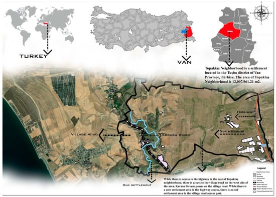
Figure 1.
Location of the study area.
Following the 23 October and 9 November 2011 Van earthquakes, modern steel-frame dwellings were constructed under the Aid to Those Who Build Their Houses (EYY) scheme, and TOKİ and AFAD relocated the settlement from fault-line and streambed locations to a safer site [56]. Conceived as a “Model Village”, Topaktaş expanded from 75 to 175 households, each allocated a 1000 m2 plot; the dwellings measured 98 m2 and the barns 62 m2 [56]. Units were delivered in 2013; however, sitting on a depressed flat plain, partial vacancy, infrastructure deficits, and the absence of water supply, feed facilities, and milking stalls in the barns were documented [57]. A holistic risk assessment indicated that the settlement is unsuitable for residential use. Following Law No. 6360 (2012), the village was reclassified as a neighborhood, yet it retains a rural landscape character rather than an urban neighborhood form; transport networks, basic services, and educational facilities remain inadequate, and water scarcity—particularly in summer—persists. Architecturally, the new housing exhibits modern villa typologies rather than traditional village forms.
3.2. Criteria and Weightings for Settlement Area Suitability
In the method, a literature review related to the subject and area of the study was carried out, verbal interviews were conducted with people currently living in the area, and on-site observation, examination, and photography were carried out. Within the scope of the study, the natural structure, socio-cultural structure, and rural architectural features of the Topaktaş rural settlement were examined. Analysis maps of the area: (CLC) CORINE Land Cover (A land cover classification database produced by the European Environment Agency since the 1990s, covering the whole of Europe) [58] slope, water and humidity, surface water seasonality, proximity to the highway, proximity to the village road, aspect, proximity to the water source, proximity to the active fault line were prepared. For this, the ArcGIS 10.8 program was used. Considering various risk factors in the village, criteria were prepared for determining suitable areas for settlement, agriculture, recreation, and industry, and developing suggestions and sub-parameters effective for each use were determined. In order to carry out the application using the AHP (Analytic Hierarchy Process) method, an analysis was carried out by revealing the weight degrees between the sub-criteria determined in the selection of the most suitable area use in Topaktaş village (Table 1). AHP is considered one of the multi-criteria decision-making methods used in complex decision-making processes and has many applications. Although the basic principles of the AHP method were determined when it was first proposed by Thomas L. Saaty, some developments and changes have been made to the method over time [59,60,61]. In order to make an objective evaluation of the criteria and sub-criteria in the selection process, a focus group consisting of landscape architects was studied, and similar sub-criteria were determined using previous studies. The settlement suitability layer classifies land as suitable (green) or unsuitable (red), referencing legacy (black) and new (white) settlement footprints.

Table 1.
Area use criteria, weightings, sub-criteria and their suitability.
3.3. Spatial Data Layers for Risk and Resource Assessment in Rural Landscapes
In line with the purpose of the study, using the spatial analysis tools of ArcGIS 10.8, Topaktaş Village Clcplus Corine, Aspect, Elevation, Slope, Distance to Fault Line, Proximity to Karasu Stream, Proximity to Highway, Proximity to Village Road, Proximity to Surface Fault Line, Surface Water, Surface Water Presence and Distribution, RPZ GIS (River Corine) maps were prepared (Figure 2, Figure 3, Figure 4, Figure 5, Figure 6, Figure 7, Figure 8, Figure 9, Figure 10, Figure 11, Figure 12, Figure 13 and Figure 14). Land cover classifications are defined in the CORINE map. In addition, the administrative boundaries of Topaktaş village show the Karasu River, highway, village road, active fault line, surface fracture, old settlement areas, and newly developed settlement areas.
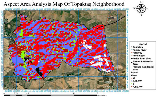
Figure 2.
Aspect Analysis Map of Topaktaş Village.
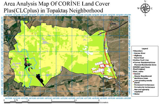
Figure 3.
CLCPlus CORINE Land Cover Map of Topaktaş Village.
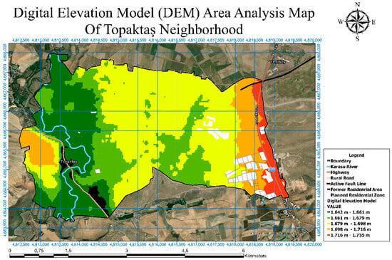
Figure 4.
Digital Elevation Model (DEM) of Topaktaş Village.
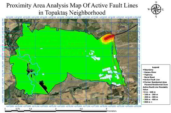
Figure 5.
Active Fault Line Analysis Map of Topaktaş Village.
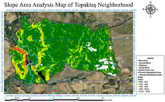
Figure 6.
Slope Analysis Map of Topaktaş Village.
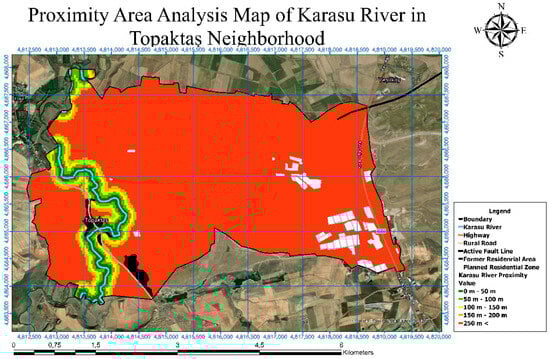
Figure 7.
Proximity to Karasu Stream Analysis Map of Topaktaş Village.
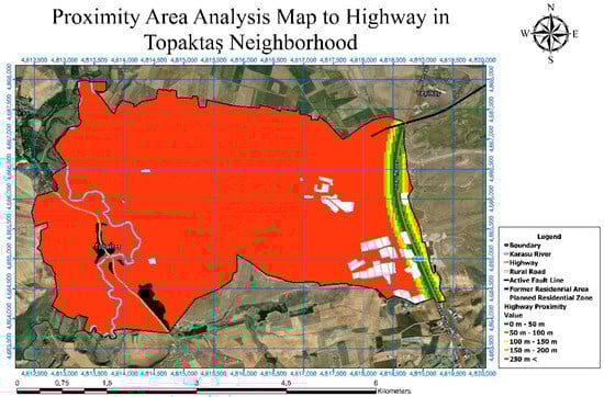
Figure 8.
Proximity to Highway Analysis Map of Topaktaş Village.
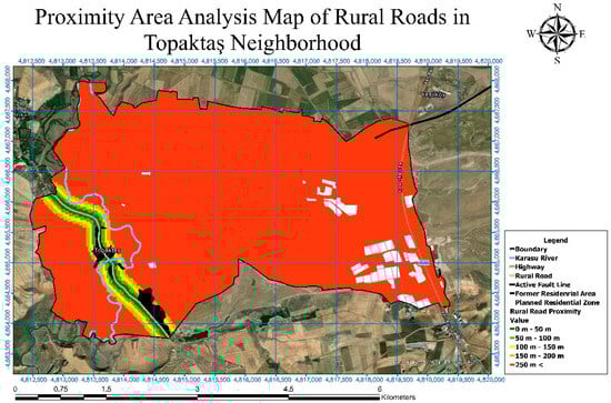
Figure 9.
Proximity to Village Road Analysis Map of Topaktaş Village.
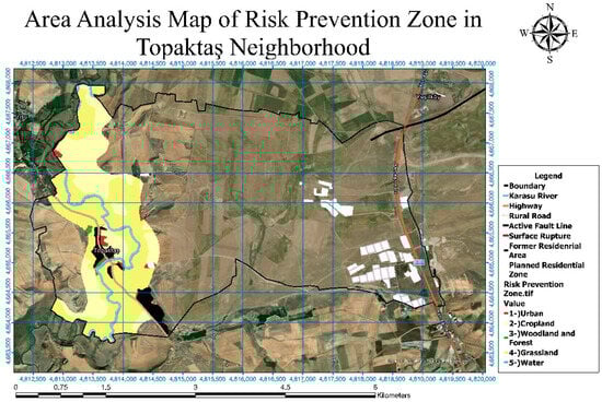
Figure 10.
Risk Presentation Zone GIS (River CORINE) Analysis Map of Topaktaş Village.
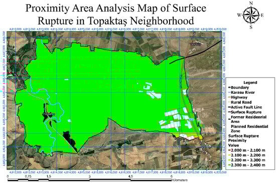
Figure 11.
Surface Fault Line Analysis Map of Topaktaş Village.
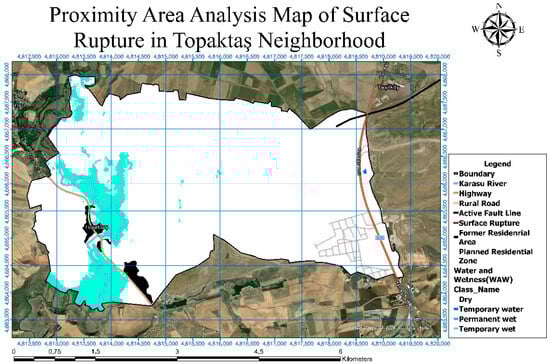
Figure 12.
Surface Water Analysis Map of Topaktaş Village.
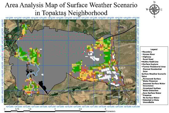
Figure 13.
Surface Water Presence and Distribution Map of Topaktaş Village.
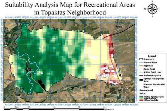
Figure 14.
Recreational Suitability Analysis Map of Topaktaş Village.
The area elevation is between 1642 m and 1735 m. The slope value of the majority of the area was 3.6%. Surface fault lines, among the risk factors, are critical indicators in assessing earthquake hazards and risks because seismic movements are concentrated along these lines, increasing the potential damage to structures [61]. RPZ (Risk Project Zone) GIS (Geographic Information System) data helps local authorities and decision-makers optimize resource allocation by determining the geographic distribution of natural disaster risks such as earthquakes, floods, and landslides [62,63,64]. In the creation of the maps, data provided by the Copernicus Land Monitoring Service [65] were utilize
Surface waters play a critical role in sustaining ecosystems and meeting various human needs such as agriculture, drinking water supply, industry, and energy production [55,56,57,58,59,60,61,62,63,64,65,66]. A surface water map is a map that shows the distribution, flow directions, and quantities of surface water bodies such as rivers, lakes, streams, and reservoirs in a given area. These maps play an important role in protecting, managing, and planning water resources. They are also used in various fields such as environmental analysis, flood risk assessment, and land use planning. Figure 2 shows slope orientations: red areas represent west-facing slopes, blue areas indicate south, southwest, and southeast orientations, green areas correspond to east-facing slopes, and brown areas denote north, northeast, and northwest orientations. In addition, the Karasu River, administrative boundaries, highway, active fault line, surface rupture, historical settlement areas, village road, and newly developed residential zones are displayed.
As shown in Figure 3, land cover classifications are defined according to categories such as sealed surfaces, broad-leaved deciduous trees, low-growing woody vegetation, permanent herbaceous vegetation, periodic herbaceous vegetation, sparsely vegetated areas, non-vegetated surfaces, and water bodies. In addition, the CORINE map displayed the administrative boundaries, the Karasu River, the highway, the village road, the active fault line, the surface rupture, historical settlement areas, and newly developed residential zones.
The elevation map in Figure 4 indicated that the area varied between a minimum altitude of 1642 m and a maximum of 1735 m. In addition to elevation data, the map presented the administrative boundaries, the Karasu River, highway, village road, active fault line, surface rupture, historical settlement areas, and newly developed residential zones. Dark green areas corresponded to altitudes of 1642–1661 m, light green areas to 1661–1679 m, yellow areas to 1679–1698 m, orange areas to 1698–1716 m, and red areas denoted the highest altitudes, ranging from 1716 to 1735 m. Based on these values, the old settlement area was located within the lowest elevation, while the new settlement area was positioned near or within the maximum elevation range.
According to Figure 5, the areas closest to the fault line and with the highest risk were marked in red, corresponding to a distance of 0–100 m from the fault line. The newly developed residential zones and the historical settlement areas were outside this red zone. The green areas shown on the map represented regions situated at a greater distance from the fault line.
As shown in Figure 6, the areas with the lowest slope (up to 3%) are represented in dark green, while the steepest areas are shown in red, with slope values ranging between 12% and 24%. Based on these data, the majority of the area had a slope ranging from 0% to 3%.
According to Figure 7, areas within 50 m of the Karasu Stream are represented in dark green. In comparison, areas situated 250 m away or farther were shown in red, indicating the most distant zones.
Figure 8 demonstrated that areas within 50 m of the highway are considered the closest zones and marked in dark green. In contrast, the most distant areas, situated beyond 250 m, were indicated in red. The highway was observed to pass near the newly developed residential zone.
In Figure 9, the proximity of areas to the village road is categorized into different distance intervals. Dark green areas corresponded to zones within 0–50 m, while light green areas indicated distances of 50–100 m. Yellow areas represented 100–150 m, orange areas 150–200 m, and red areas symbolized regions 250 m or farther from the village road. Notably, dark green zones were located within the boundaries of the old settlement area.
The RPZ (risk probability Project Zone) GIS data refer to the digital mapping and analysis of geographically defined areas based on specific risk criteria, widely applied in disaster management, urban planning, and environmental risk assessment [62]. By integrating multiple data layers, GIS technology enables detailed spatial analysis of the risk levels associated with RPZs, thereby facilitating preparedness, response, and recovery processes. RPZ GIS data further assist local authorities and decision-makers in optimizing resource allocation by identifying the spatial distribution of natural disaster risks such as earthquakes, floods, and landslides [63,64,66]. Spatial analyses provided by GIS play a critical role in determining risk-prone areas; for instance, in earthquake-prone regions, parameters such as soil composition, building density, and population distribution are analyzed to delineate the boundaries of RPZs [67]. These datasets serve as guiding tools for minimizing risks in planning processes and promoting sustainable urban development. According to the analysis presented in the map, areas marked in red represent urban zones, yellow areas indicate cultivated land, dark green areas correspond to forested regions, orange areas denote pastures, and blue areas signify water bodies (Figure 10).
A surface fault line is a fracture extending to the Earth’s surface, typically associated with seismic activities such as earthquakes. This fault line represents the release of stress within the crust, manifested as slippage or rupture reaching the surface. Surface fault lines are considered critical indicators in assessing earthquake hazards and risks, as seismic movements tend to concentrate along these zones, thereby increasing the potential damage to structures [61]. In the map, red areas corresponded to elevations between 2000 and 2100 m, orange areas ranged between 2100 and 2200 m, while dark green areas represented elevations between 2300 and 2400 m (Figure 11).
As shown in Figure 12, surface water areas include lakes, rivers, streams, wetlands, and reservoirs that are directly connected to atmospheric and hydrological processes. These water bodies have played a vital role in sustaining ecosystems and meeting human needs such as agriculture, drinking water supply, and energy production. The map highlighted the spatial distribution of these resources, emphasizing their importance for effective water resource management and environmental sustainability.
As shown in Figure 13, permanent surface water is represented in dark green, seasonal surface water in light green, occasional surface water in orange, rare surface water in red, and areas without surface water in gray. The map emphasized the spatial distribution and occurrence patterns of rivers, lakes, streams, and reservoirs within the study area.
4. Results
In this study, the comprehensive effect of multiple factors on the land use pattern in Topaktaş village was analyzed, and the complex interactions between these factors were examined in detail in order to strengthen the guiding importance and practical application value of the research findings. Considering the various risk factors in Topaktaş village, the use suitability situations for settlement, agriculture, recreation and industry areas were determined using AHP and GIS application (Figure 14, Figure 15, Figure 16, Figure 17, Figure 18 and Figure 19). The maps were developed by taking into account several factors, including slope, elevation, water and moisture conditions, proximity to active fault lines, seasonality of surface water, overall risk, prevention zone, CLCPlus land cover, proximity to highways and village roads, aspect, and distance to surface ruptures of fault lines. The suitability maps for optimum land use were created to ensure that this region was evaluated in the most efficient and sustainable way among different land use types. The optimum land use map was prepared by superimposing agricultural, industrial, residential and recreational maps and excluding risky areas. Accordingly, while the areas at high elevations on the map are suitable for recreation, the areas suitable for settlement are those 100 m away from the stream bed. This layer identifies recreation-suitable zones (green) versus unsuitable zones (red) under a multi-criteria framework. Suitability improves on gently sloping terrain at moderate elevations, with adequate moisture, benign surface-water seasonality, and sufficient buffers from active/surface-rupture fault traces. Accessibility matters, but proximity to major roads is down-weighted, where noise, safety, or landscape fragility would degrade recreational quality. Taken together, the map prioritizes low-risk, ecologically supportive patches that can sustain nature-based leisure without compromising safety or environmental integrity.
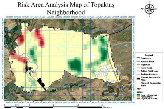
Figure 15.
Risk Analysis Map of Topaktaş Village.
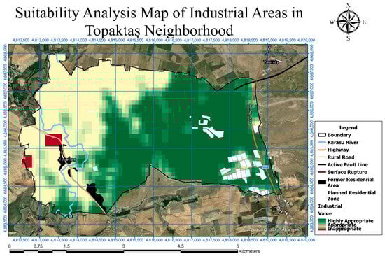
Figure 16.
Industrial Suitability Analysis Map of Topaktaş Village.
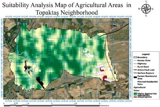
Figure 17.
Agricultural Suitability Analysis Map of Topaktaş Village.
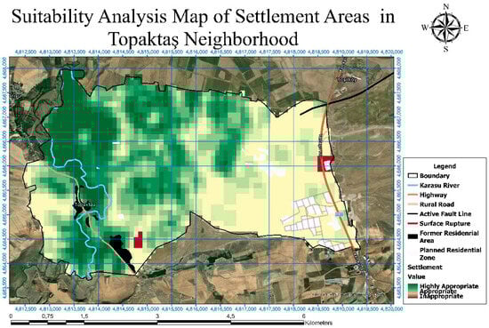
Figure 18.
Settlement Suitability Analysis Map of Topaktaş Village.
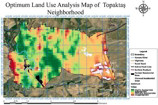
Figure 19.
Optimum Land Use Suitability Map of Topaktaş Village.
The risk surface stratifies the landscape into non-risk (green), low-risk (yellow), and high-risk (red) classes by jointly considering slope, aspect, elevation, land cover (CLCPlus), distances to active and surface-rupture faults, and surface-water seasonality. High-risk clusters align with seismic corridors and hydrologically exposed tracts, even where baseline slopes are gentle. This layer should be treated as a hard constraint when interpreting all other suitability products, limiting interventions in red zones and prescribing targeted mitigation in yellow areas (Figure 15).
Industrial suitability favors locations that balance logistical access (especially to highways) with safety margins from seismic features and seasonal inundation. Green areas typically occur on stable ground classes and moderate slopes and outside 0–100 m buffers from mapped faults and major channels; red areas reflect construction, compliance, or business-continuity risks (e.g., steep gradients, forested tracts, or hydrologically sensitive corridors). The map thus guides siting toward serviceable yet resilient plots that minimize externalities (Figure 16).
Agricultural suitability improves on gentle slopes with favorable elevation bands and reliable—but not hazardous—moisture regimes. Proximity to the Karasu Stream can be advantageous for irrigation potential, provided flood exposure and soil instability are managed; sealed or densely built covers are downgraded. The classification consequently emphasizes cultivable, accessible soils while avoiding hydrologic and seismic penalties (Figure 17).
Settlement suitability weights stable topography, adequate distances from active/surface-rupture faults, and limited surface-water seasonality while preserving access to the road network. Legacy (old) settlements tend to occupy lower elevation bands, whereas newer footprints appear closer to the maximum elevation range—underlining the need for elevation- and seismic-aware buffers in expansion planning. Green zones reflect comparatively low exposure with serviceable access; red zones denote sites where geotechnical or hazard constraints dominate (Figure 18).
This composite map integrates the four thematic suitability layers—agriculture, industry, settlement, and recreation—using GIS with an Analytic Hierarchy Process (AHP) framework and excludes high-risk zones from consideration. Dark green areas denote the most suitable locations, light green/yellow indicate moderate suitability, and red marks unsuitable tracts.
The approach seeks the most efficient and sustainable allocation of land uses by balancing ecological potential with hazard constraints, thereby guiding planning toward contiguous, accessible, and resilient parcels while reserving marginal areas for protection or restoration (Figure 19).
A holistic evaluation of the analytical diagrams reveals a distinct pattern of rural landscape transformation in Topaktaş. Legacy settlements were primarily located at lower elevations (1642–1661 m), whereas the newly constructed housing footprints were shifted toward higher elevation zones (1716–1735 m). The majority of the study area consists of gently sloping terrain (0–3%), which provides advantages in terms of accessibility and infrastructure development. However, clusters of high-risk zones concentrated along active fault corridors highlight potential contradictions in the siting of new settlements. Agricultural suitability analyses indicate that areas adjacent to the Karasu Stream—yet outside flood-prone tracts—are most favorable, while recreation suitability is concentrated in mid-elevation ecological corridors that benefit from higher moisture and microclimatic advantages. Industrial suitability favors areas with strong highway accessibility but at safe distances from seismic and hydrological hazards. The composite optimum land-use map (Figure 19) integrates these four primary functions—settlement, agriculture, industry, and recreation—while excluding high-risk zones, thereby offering a sustainable and implementable spatial scenario. In this way, the overarching land-use tendencies and patterns of rural landscape change are explicitly demonstrated through a multi-criteria and risk-constrained framework.
5. Discussion
The significance of this study lies in its ability to bridge the gap between rural landscape, cultural heritage preservation, ecological sustainability, and spatial planning. As highlighted in the study of Plieninger and Bieling [68], traditional villages represent more than clusters of old buildings; they embody collective memory, identity, and practices that have evolved in harmony with the environment. In the context of rapid urbanization, industrialization, and socio-economic transformation, the disappearance or degradation of these landscapes would not only result in a loss of cultural heritage but also weaken the socio-ecological resilience of local communities. By analyzing the spatial, cultural, and ecological dimensions of village landscapes, the present research contributes to the understanding of how historical settlement patterns can inform contemporary planning frameworks. In line with this, Antrop [69] stated that landscapes of the past are not merely remnants of history but essential references for shaping resilient and meaningful futures. His argument reinforces the view that preserving traditional cultural landscapes provides continuity, identity, and guidance in the face of rapid urbanization and globalization. Thus, the present research aligns with Antrop’s [69], arguing through demonstration that the protection of old villages was not a nostalgic endeavor but a strategic necessity to balance modernization with cultural and ecological sustainability.
An integrated analysis of the Topaktaş case further highlights the multi-dimensional drivers of rural landscape change. Demographic shifts, particularly the depopulation of historic settlements and the partial abandonment of new housing units, have disrupted the continuity of traditional livelihoods such as animal husbandry. Environmental constraints, including water scarcity, seismic risk along active and surface-rupture faults, and topographic limitations, have also strongly influenced the transformation of settlement patterns. In addition, socio-economic pressures—such as the inadequacy of agricultural productivity under new land allocations and the limited functionality of newly constructed barns—have reduced the viability of rural livelihoods. Within this context, the planning and management framework developed in the study responds directly to these pressures by converting spatial analyses into actionable strategies. These include mandatory no-build setbacks of 0–100 m from active fault lines, riparian buffer zones to mitigate flood and irrigation conflicts, slope and elevation thresholds to guide settlement expansion, and the allocation of recreational and agricultural zones to balance ecological integrity with community well-being. Together, these measures not only provide a scientifically grounded rationale for land-use planning but also demonstrate how risk-informed and culturally sensitive strategies can enhance the resilience of rural landscapes in post-disaster contexts.
Li et al. [70] highlighted the contrasting trajectories of rural areas, distinguishing between intermediate regions near city centers and peripheral regions beyond urban economic influence. While intermediate areas with sufficient population density and connectivity can benefit from knowledge spillovers and urban markets, peripheral regions often remain disadvantaged. Crucially, rural development is shaped by both endogenous and exogenous factors, where bonding and bridging social capital play a vital role in enabling adaptation and transformation. The findings also emphasize that reliance on agricultural subsidies is insufficient; instead, diversification and integration with wider socio-economic networks are essential for fostering resilience and sustainable rural development.
This study was particularly relevant because it highlighted the importance of integrating rural landscapes into district-level spatial planning and governance. Many planning policies prioritize economic growth and infrastructure development while overlooking the intangible cultural and ecological values that sustain long-term well-being. The study demonstrates that protecting traditional settlements is not merely a cultural obligation but a strategic component of sustainable regional development. Such an approach ensures continuity between past and future, allowing communities to retain their unique identity while adapting to modern challenges. Especially, geographic information technology has advanced to become an indispensable tool in analyzing, monitoring, and managing rural and cultural landscapes. Its applications allow researchers and planners to detect patterns of decline, measure land-use changes, and assess ecological and social vulnerabilities with greater precision. By integrating spatial data with socio-economic indicators, it becomes possible to identify villages at risk and develop targeted strategies for preservation and revitalization. Moreover, geographic technologies enhance participatory planning by visualizing scenarios that engage local communities in decision-making. This technological capacity strengthens the resilience of rural areas, ensuring that cultural heritage is sustained alongside contemporary development [59,60,61,70,71,72]. Moreover, the findings highlighted the importance of participatory approaches and showed that active involvement of residents was crucial for long-term success. Local engagement fosters heritage-based tourism, ecological conservation, and socio-economic revitalization while also supporting global sustainability goals such as cultural preservation and inclusive development.
This study connected rural landscape, cultural-heritage preservation, ecological sustainability, and spatial planning by analyzing historic village patterns through GIS–AHP evidence. In Topaktaş, the DEM and suitability layers show that legacy (old) footprints occupy lower elevation bands, whereas the new footprints cluster near the maximum elevation range—an important transformation with planning implications (Figure 4 and Figure 18). The risk overlay further indicates that the 0–100 m fault corridor constitutes a no-build constraint, with both old and new settlements located outside this highest-risk zone (Figure 15). In addition, the slope map shows that most of the area lies within 0–3% gradients, supporting low-impact access and service provision where hazard and hydrologic constraints are manageable. Surface-water’s presence and seasonality delimit riparian buffers and enable nature-based recreation corridors while safeguarding ecological function (Figure 12, Figure 13 and Figure 14). Consistent with Plieninger & Bieling [66] and Antrop [67], traditional landscapes are treated not as nostalgic relics but as living references for resilient futures; the multi-criteria suitability and the optimum land-use map operationalize this view by converting cultural–ecological values and risk constraints into zoning, buffers, and phased management actions (Figure 14, Figure 15, Figure 16, Figure 17, Figure 18 and Figure 19).
6. Conclusions and Implications
Rural landscapes have the characteristics of providing living spaces for living beings, offering recreational opportunities, creating a transition zone between urban and natural areas, meeting animal and plant food production needs, being landscapes with high visual landscape value, reflecting cultural identity values, containing vernacular architectural examples, providing employment, having agro-tourism value and having a unique landscape character. Old villages had rural landscape character due to their settlement patterns in harmony with their natural topography, proximity to water resources and suitable climate conditions, creating a suitable environment for agricultural production and animal husbandry. This study has certain limitations. Most notably, its reliance on a single case (Topaktaş) naturally constrains the generalizability of the findings. Nevertheless, because Topaktaş was redesigned and relocated following the 2011 Van earthquakes, this singular case is exceptionally instructive. The study provides a framework for interpreting post-disaster rural settlements through a planning and management lens: (i) transforming GIS–AHP outputs from descriptive maps into practical decision-support elements (setbacks, buffers, hazard overlays, threshold values); (ii) linking recreation, agriculture, industry, and settlement suitability with risk constraints to suggest an integrated land-use configuration; and (iii) outlining implications for accessibility, infrastructure, and social acceptance in post-relocation settings. While this case has limitations, the Topaktaş example offers useful insights that may inform studies of other rural landscapes and post-disaster reconstruction contexts.
In the study area, the rural landscape change process occurred at a local scale and due to natural disasters in the 2011–2025 time period (post-earthquake). According to the quantitative and qualitative research, this change was experienced in the settlement area, but it had a broader reflection of the agricultural activities and lifestyles of the villagers. In the old years before the earthquake in Topaktaş village, it was decided to build houses at lower elevations in the settlement area selection with traditional methods. It is revealed that in the historical process, Topaktaş residents clearly preferred to settle near water bodies. However, despite the advancement of geographical information technology today and the possibility of more accurate land use selection, the decision to build new houses at high elevations was made and implemented in the new planning. It was also determined that some village residents rented the houses built in the new settlement area to those living in the city with the intention of summer houses. In addition, it was revealed that some villagers used the existing barn and even their houses in the old settlement area. In the verbal interviews, it was revealed that even those who used to live in the village no longer wanted to live in this village due to this serious problem and that they could not continue their previous animal husbandry in the barns allocated to them near the new housing types and which were not large enough. This situation caused the restriction of animal husbandry in the village, and the prevalence of this important visual of the rural landscape was eliminated.
Based on the findings of this study, direct implications are presented for the implementation of the current rural revitalization and spatial planning policies of Topaktaş village.
The feasible suggestions of local administrators to facilitate the return of those who previously lived in the village to the village and to ensure that the new generation lives in the area are given below:
- 1
- To show enough care that the housing types in the settlement area suggested on the map with the analysis of the GIS software that will eliminate water shortage are compatible with the identity of the local architecture and the rural area.
- 2
- To create a suitable entrepreneurial environment in order to reintroduce and contribute to the sustainability of large cattle farming, which is almost never done in the area, to build barns of sufficient size for each household or to build several barns that can provide collective service, and to establish a veterinary clinic.
- 3
- To provide encouraging economic support for production and sales in order to increase agricultural productivity and generate income, and also to provide training on application methods.
- 4
- To take encouraging initiatives for afforestation works from local plant species in the village.
- 5
- Proposal for energy production with solar panels in the east of the neighborhood. Solar panels can be installed in areas with high sunlight direction and rate, and an energy system can be created for the neighborhood.
- 6
- Positioning of correct directional signs starting from the main street;
- 7
- Placing various ergonomic urban equipment elements in appropriate places in the proposed recreation areas to increase the quality of life;
- 8
- Establishing local art workshops to provide a different occupation and socialization skills development for the people living in the region, and providing practical training in the relevant field if necessary.
In the face of ongoing urbanization and economic transformation, it is crucial that local governments integrate the protection of old villages into district-level spatial planning and ensure that land use regulations safeguard cultural and historical landscapes. Enacting protection laws is essential to prevent the uncontrolled expansion of non-local structures and to preserve the unique identity of these villages, while simultaneously encouraging the active participation of residents in conservation efforts. Furthermore, maintaining the ecological and aesthetic value of the river passing through the village requires the implementation of periodic cleaning and landscape restoration activities. In addition, neighborhood planning should prioritize the reconstruction and improvement of transportation networks, thereby enhancing connectivity and accessibility. Finally, the creation of recreation areas, strategically recommended through spatial analyses and aligned with the socio-economic characteristics of the region, will contribute to both the cultural preservation and sustainable development of the area.
The recommendations developed in this study, which are anticipated to be implemented in the process following the 2011 Van earthquake, can be a guide for planning in areas experiencing rural landscape change and villages experiencing similar conditions after natural disasters.
The research findings have revealed that rural landscape change occurs under the influence of various change dynamics and produces processes that differ from each other according to the characteristics of the landscape. Future research could, first, adopt comparative case studies within the Van basin and other rural settings to verify the transferability of the findings. Second, longitudinal change detection using remote-sensing time series (e.g., Sentinel/Landsat) together with high-resolution DEMs may offer finer temporal and topographic detail. Third, scenario building that considers multiple hazards, including seismic and hydrological risks, could provide a more comprehensive understanding of exposure. Fourth, methodological triangulation through sensitivity analysis and selected multi-criteria approaches would help assess the robustness of the results. Finally, participatory GIS and indicative ecosystem-services valuation could be explored to strengthen planning decisions while maintaining a realistic and context-specific perspective.
Author Contributions
Conceptualization: F.A., K.K. and O.Y.; data curation: O.Y.; formal analysis: F.A. and S.K.; methodology: F.A., K.K. and O.Y.; resources: K.K.; visualization: O.Y., S.K. and F.A.; writing—original draft: K.K. and F.A.; writing—review and editing: K.K. and F.A. All authors have read and agreed to the published version of the manuscript.
Funding
This study was not supported by any funding source.
Data Availability Statement
The original contributions presented in this study are included in the article. Further inquiries can be directed to the corresponding author.
Acknowledgments
We would like to thank the anonymous reviewers for their valuable comments and suggestions for improving this paper.
Conflicts of Interest
The authors declare no conflicts of interest.
References
- Yıldız, F.Ö. Problems of Conservation in Rural Architecture: The Case of Alımlı Village, Mardin. Master’s Thesis, Institute of Graduate Education, Fatih Sultan Mehmet University, Istanbul, Turkey, 2019. Available online: https://dergipark.org.tr/en/download/article-file/1665172 (accessed on 13 April 2024).
- Naycı, N. Architectural Characteristics and Conservation Problems of Traditional Rural Settlements in the Datça-Bozburun Region. TÜBA-KED 2012, 10, 81–105. [Google Scholar] [CrossRef]
- Ahunbay, Z. Principles Regarding the Conservation of Rural Landscapes. In Proceedings of the ICOMOS International Day for Monuments and Sites 2019 Events—Symposium on Rural Architectural Heritage, Eskişehir, Turkey, 26–28 April 2019; pp. 1–2. [Google Scholar]
- Güler, K. Depopulation of Historic Rural Settlements: Causes, Effects, and Possibilities for Reuse. In Proceedings of the ICOMOS International Day for Monuments and Sites 2019 Events—Symposium on Rural Architectural Heritage, Eskişehir, Turkey, 26–28 April 2019; pp. 6–13. [Google Scholar]
- Zhang, Y.; Huang, J.; Zhang, K. Evaluation of regional characteristics of rural landscapes in the Yangtze River Delta from the perspective of the ecological–production–living concept. Sustainability 2025, 17, 5057. [Google Scholar] [CrossRef]
- Lv, W.; Ji, S. Atmospheric environmental quality assessment method based on analytic hierarchy process. Discret. Contin. Dyn. Syst. 2019, 12, 941–955. [Google Scholar] [CrossRef]
- Ying, B.; Li, S.; Xiong, K.; Hou, Y.; Liu, T.; Sun, R. Research on the Resilience Assessment of Rural Landscapes in the Context of Karst Rocky Desertification Control: A Case Study of Fanhua Village in Guizhou Province. Forests 2023, 14, 733. [Google Scholar] [CrossRef]
- Gulinck, H.; Múgica, M.; de Lucio, J.V.; Atauri, J.A. A framework for comparative landscape analysis and evaluation based on land cover data, with an application in the Madrid region (Spain). Landsc. Urban Plan. 2001, 55, 257–270. [Google Scholar] [CrossRef]
- Shen, H.; He, X.; He, J.; Li, D.; Liang, M.; Xie, X. Back to the Village: Assessing the Effects of Naturalness, Landscape Types, and Landscape Elements on the Restorative Potential of Rural Landscapes. Land 2024, 13, 910. [Google Scholar] [CrossRef]
- ASLA (American Society of Landscape Architects). Rural Landscapes, Policy Statement. 2023. Available online: https://www.asla.org/uploadedFiles/CMS/Government_Affairs/Public_Policies/Rural_Landscapes.pdf (accessed on 10 April 2024).
- Zhu, L.; Wu, L.; Xu, X.; Chen, X. Exploring Pathways for Stimulating Cultural Services in Rural Ecosystems through Experiential Learning Education. Sustainability 2024, 16, 8117. [Google Scholar] [CrossRef]
- Scazzosi, L. Rural landscape as heritage: Reasons for and implications of principles concerning rural landscapes as heritage. Built Herit. 2018, 2, 39–52. [Google Scholar] [CrossRef]
- Aşur, F.; Akpınar Külekçi, E.; Perihan, M. The role of urban landscapes in the formation of urban identity and urban memory relations the case of Van Turkiye. Plan. Perspect. 2022, 37, 841–857. [Google Scholar] [CrossRef]
- ICOMOS. ICOMOS-IFLA Principles Concerning Rural Landscapes as Heritage. Available online: https://www.icomos.org.tr/Dosyalar/ICOMOSTR_en0887771001560505611.pdf?utm (accessed on 14 September 2024).
- Akdeğirmen Ercan, S.; Gençer, C.İ. A Rural Landscape Reading Through Contınuity and Change: Gölova Rural Neighborhood (Village) In Elmalı Distrıct of Antalya Province. J. Art Hist. 2024, 33, 325–359. [Google Scholar] [CrossRef]
- Vries, D.; Timo, W. Social Aspects in Land Consolidation Processes. Land 2022, 11, 452. [Google Scholar] [CrossRef]
- Wang, Z.; Zhou, Q.; Man, T.; He, L.; He, Y.; Qian, Y. Delineating Landscape Features Perception in Tourism-Based Traditional Villages: A Case Study of Xijiang Thousand Households Miao Village, Guizhou. Sustainability 2024, 16, 5287. [Google Scholar] [CrossRef]
- Bürgi, M.; Hersperger, A.M.; Schneeberger, N. Driving forces of landscape change—Current and new directions. Landsc. Ecol. 2004, 19, 857–868. [Google Scholar] [CrossRef]
- Santoro, A.; Piras, F.; Fiore, B.; Bazzurro, A.; Agnoletti, M. Forest cover changes in European Natura 2000 sites in the period 2012–2018. Forests 2024, 15, 232. [Google Scholar] [CrossRef]
- Wu, J. Urban ecology and sustainability: The state-of-the-science and future directions. Landsc. Urban Plan. 2014, 125, 209–221. [Google Scholar] [CrossRef]
- Parven, A.; Pal, I.; Witayangkurn, A.; Pramanik, M.; Nagai, M.; Miyazaki, H.; Wuthisakkaroon, C. Impacts of disaster and land-use change on food security and adaptation: Evidence from the delta community in Bangladesh. Int. J. Disaster Risk Reduct. 2022, 78, 103119. [Google Scholar] [CrossRef]
- Wang, D.; Zhu, Y.; Zhao, M.; Lv, Q. Multi-dimensional hollowing characteristics of traditional villages and its influence mechanism based on the micro-scale: A case study of Dongcun Village in Suzhou, China. Land Use Policy 2021, 101, 105146. [Google Scholar] [CrossRef]
- Wood, R.; Handley, J. Landscape Dynamics and the Management of Change. Landsc. Res. 2001, 26, 45–54. [Google Scholar] [CrossRef]
- Penghui, J.; Dengshuai, C.; Manchun, L. Farmland landscape fragmentation evolution and its driving mechanism from rural to urban: A case study of Changzhou City. J. Rural Stud. 2021, 82, 1–18. [Google Scholar] [CrossRef]
- Pinto-Correia, T.; Primdahl, J.; Pedroli, B. What is the rural landscape about? In European Landscapes in Transition: Implications for Policy and Practice; Cambridge University Press: Cambridge, UK, 2018; pp. 42–63. [Google Scholar]
- Doğan, D.; Bulut, M.B.B.; Yılmaz, M. Visual Quality Assessment of Rural Landscapes: The Case of Gölbaşı, Ankara. MAS J. Appl. Sci. 2023, 8, 924–937. [Google Scholar]
- Büyükköz, H. The Impact of Urban Developments on Rural Landscape: Sarıyer Example. Ph.D. Thesis, Institution of Science, Mimar Sinan Fine Arts University, Istanbul, Turkey, 2024. [Google Scholar]
- Cloke, P.; Little, J. (Eds.) Contested Countryside Cultures: Otherness, Marginalisation and Rurality; Routledge: London, UK, 1997; ISBN 0-203-97412-3. [Google Scholar]
- Gallent, N.; Juntti, M.; Kidd, S.; Shaw, D. Introduction to Rural Planning: Economies, Communities and Landscapes; Routledge: London, UK, 2008. [Google Scholar]
- Alexander, C. The Timeless Way of Building; Oxford University Press: New York, NY, USA, 1979. [Google Scholar]
- Ozorhon, I.F.; Ozorhon, G. Rural architecture and sustainability: Learning from the past. J. Asian Rural Stud. 2021, 5, 30–47. [Google Scholar] [CrossRef]
- Eminağaoğlu, Z.; Çevik, S. Design politics and tools for rural areas. Gazi Univ. J. Eng. Archit. 2007, 22, 157–162. [Google Scholar]
- Yazici, K.; Gülgün, B.; Ankaya, F. Potential of Rural Tourism and Ecotourism and SWOT Analysis Case of Başkale Van Turkiye and Its Surroundings. Karabuk Univ. J. Inst. Soc. Sci. 2017, 3, 131–144. [Google Scholar]
- Koç, C.; Koç, A. Conservation of Rural Heritage: Case of Hırkatepe in Beypazarı (Ankara). Atatürk Univ. J. Agric. Fac. 2019, 50, 263–273. [Google Scholar]
- Chisholm, M. Rural Settlement and Land Use: An Essay in Location; Hutchinson: London, UK, 1968. [Google Scholar]
- McClelland, L.F.; Keller, J.T.; Keller, G.P.; Melnick, R.Z. National Register Bulletin 30: Guidelines for Evaluating and Documenting Rural Historic Landscapes; Department of the Interior, National Park Service, Cultural Resources: Washington, DC, USA, 1999.
- Özsüle, Z. An Assessment of Cultural Landspace for the Conservation of Traditional Settlements: A Case Study of Mudanya. Ph.D. Thesis, Institute of Science, Istanbul University, Istanbul, Turkey, 2005. [Google Scholar]
- Xiao, S.Y.; Bai, S.J. Predicaments of Heritage of Rural Cultural Landscape during Urbanization and its Solutions. Appl. Mech. Mater. 2013, 357–360, 2075–2078. [Google Scholar] [CrossRef]
- Gündüz, E. Determination of Sustainable Development Strategies Focused on Rural Tourism, Kilistra Sample. PLANARCH-Des. Plan. Res. 2023, 7, 8–18. [Google Scholar] [CrossRef]
- Ayhan, H.; Karakayacı, Z.; Yener, A. Sustainable Rural Land Management. Acad. Meat Milk Inst. J. (Akad. Et Ve Süt Kurumu Derg.) 2024, 7, 30–38. [Google Scholar]
- Fowler, P.J. World Heritage Cultural Landscapes 1992-2002; World Heritage Papers 6; UNESCO World Heritage Centre: Paris, France, 2003. [Google Scholar]
- Luengo, A. World Heritage Agricultural Landscapes. In World Heritage Review; UNESCO World Heritage Centre: Paris, France, 2013; Volume 69, pp. 6–13. [Google Scholar]
- Ganasri, B.P.; Ramesh, H.J.G.F. Assessment of soil erosion by RUSLE model using remote sensing and GIS-A case study of Nethravathi Basin. Geosci. Front. 2016, 7, 953–961. [Google Scholar] [CrossRef]
- Brunet-Vinck, V. Méthode Pour les Atlas de Paysages: Enseignements Méthodologiques de dix ans de Travaux. Ministère de l’Écologie et du Développement Durable, France. 2004. Available online: https://side.developpement-durable.gouv.fr/Default/doc/SYRACUSE/292850/methode-pour-les-atlas-de-paysages-enseignements-methodologiques-de-10-ans-de-travaux?_lg=fr-FR (accessed on 12 March 2025).
- Ministère de l’Environnement, M.; de l’Énergie et de la Mer. Biodiversité et Paysages. Available online: http://www.developpement-durable.gouv.fr/politiques/biodiversite-et-paysages (accessed on 20 November 2024).
- Swanwick, C. Landscape Character Assessment: Guidance for England and Scotland; Countryside Agency and Scottish Natural Heritage: Cheltenham, UK, 2002. [Google Scholar]
- Tisma, A.; Meijer, J. Integral Landscape Planning in the Netherlands: Lessons Learned from the Intentions and Consequences. Int. J. Sustain. Dev. Plan. 2018, 13, 244–254. [Google Scholar]
- Eminağaoğlu, Z.; Çevik, S. Evaluation of design and planning policies regarding rural settlements within the regional scale. J. Plan. 2005, 32, 72–81. [Google Scholar]
- Ministry of Forestry and Water Affairs. Official Website of the Ministry of Forestry and Water Affairs. Available online: https://www.tarimorman.gov.tr/SYGM (accessed on 21 September 2020).
- Ada, E.; Yener, D. Rural landscape approach in Turkiye and a comparison within the framework of European countries. Int. J. Rural Tour. Dev. 2017, 1, 8–13. [Google Scholar]
- Uzun, O.; Müderrisoğlu, H.; Demirel, Ö. Project Team Yeşilırmak Basin Landscape Atlas Project (2012–2015); Project Report; Department of Landscape Conservation; Ministry of Agriculture and Forestry: Ankara, Turkiye, 2015. [Google Scholar]
- World Bank. Turkiye Resilient Landscape Integration Project (TULIP): Implementation Status & Results Report; World Bank: Washington, DC, USA, 2021; Report No. P172562. [Google Scholar]
- Ministry of Agriculture and Forestry. Konya Bozkır–Seydişehir–Ahırlı–Yalıhüyük and Suğla Lake Landscape Management, Conservation and Planning Project (2008–2010); Project Report; Ministry of Agriculture and Forestry: Ankara, Turkiye, 2010. [Google Scholar]
- TurkStat. Turkish Statistical Institute. 2023. Available online: https://data.tuik.gov.tr/Bulten/Index?p=Adrese-Dayali-Nufus-Kayit-Sistemi-Sonuclari-2023-49684 (accessed on 12 March 2025).
- Cay, T.; Uyan, M. Evaluation of reallocation criteria in land consolidation studies using the Analytic Hierarchy Process (AHP). Land Use Policy 2013, 30, 541–548. [Google Scholar] [CrossRef]
- Yılmaz, E.T.G.; A New Life in Villages Erased from the Map. Arkitera. Available online: https://www.arkitera.com/haber/haritadan-silinen-koylerde-yeni-hayat/ (accessed on 12 April 2013).
- Özbir, N. Van House Design in the Context of the Kitchen. J. Istanb. Aydın Univesity 2017, 9, 63–77. [Google Scholar]
- European Environment Agency. CORINE Land Cover. Copernicus Land Monitoring Service. 2025. Available online: https://land.copernicus.eu/en/products/corine-land-cover (accessed on 23 May 2025).
- Mosadeghi, R.; Warnken, J.; Tomlinson, R.; Mirfenderesk, H. Comparison of Fuzzy-AHP and AHP in a spatial multi-criteria decision making model for urban land-use planning. Comput. Environ. Urban Syst. 2015, 49, 54–65. [Google Scholar] [CrossRef]
- Li, R.; Zhang, Y.; Li, W.; Xu, X. Identification Model of Traditional Village Cultural Landscape Elements and Its Application from the Perspective of Living Heritage—A Case Study of Chentian Village in Wuhan. Buildings 2024, 14, 3535. [Google Scholar] [CrossRef]
- Stein, S.; Wysession, M. An Introduction to Seismology, Earthquakes, and Earth Structure; Wiley-Blackwell: Hoboken, NJ, USA, 2023. [Google Scholar]
- Burrough, P.A.; McDonnell, R.A. Principles of Geographical Information Systems; Oxford University Press: Oxford, UK, 1998. [Google Scholar]
- Longley, P.A.; Goodchild, M.F.; Maguire, D.J.; Rhind, D.W. Geographic Information Systems and Science, 4th ed.; Wiley: Hoboken, NJ, USA, 2015. [Google Scholar]
- Goodchild, M.F. Citizens as sensors: The world of volunteered geography. GeoJournal 2007, 69, 211–221. [Google Scholar] [CrossRef]
- Copernicus Land Monitoring Service. 2025. Available online: https://land.copernicus.eu/en (accessed on 23 April 2025).
- DPT. Turkiye Water Report; State Planning Organization: Ankara, Turkey, 2001. [Google Scholar]
- EPA. Surface Water. Environmental Protection Agency. 2023. Available online: https://www.epa.gov/waterdata/surface-water-quality-modeling?utm (accessed on 14 May 2025).
- Plieninger, T.; Bieling, C. Resilience and the Cultural Landscape: Understanding and Managing Change in Human-Shaped Environments; Cambridge University Press: Cambridge, UK, 2013. [Google Scholar]
- Antrop, M. Why landscapes of the past are important for the future. Landsc. Urban Plan. 2005, 70, 21–34. [Google Scholar] [CrossRef]
- Li, Y.; Westlund, H.; Liu, Y. Why some rural areas decline while some others not: An overview of rural development theories. J. Rural Stud. 2019, 68, 135–143. [Google Scholar] [CrossRef]
- Li, G.; CAO, Y.; He, Z.; He, J.; Cao, Y.; Wang, J.; Fang, X. Understanding the Diversity of Urban–Rural Fringe Development in a Fast Urbanizing Region of China. Remote Sens. 2021, 13, 2373. [Google Scholar] [CrossRef]
- de la Fuente de Val, G.; Atauri, J.A.; de Lucio, J.V. Relationship between landscape visual attributes and spatial pattern indices: A test study in Mediterranean-climate landscapes. Landsc. Urban Plan. 2006, 77, 393–407. [Google Scholar] [CrossRef]
Disclaimer/Publisher’s Note: The statements, opinions and data contained in all publications are solely those of the individual author(s) and contributor(s) and not of MDPI and/or the editor(s). MDPI and/or the editor(s) disclaim responsibility for any injury to people or property resulting from any ideas, methods, instructions or products referred to in the content. |
© 2025 by the authors. Licensee MDPI, Basel, Switzerland. This article is an open access article distributed under the terms and conditions of the Creative Commons Attribution (CC BY) license (https://creativecommons.org/licenses/by/4.0/).