Article

Analysis of Public Space Characteristics in Traditional Villages Along the Western Beijing Cultural Belt and Their Behavioral Adaptation to Residents: A Multi-Scale Perspective Study

School of Landscape Architecture, Beijing Forestry University, Beijing 100083, China
*
Author to whom correspondence should be addressed.
Land 2025, 14(10), 1982; https://doi.org/10.3390/land14101982
Submission received: 20 August 2025 / Revised: 12 September 2025 / Accepted: 29 September 2025 / Published: 1 October 2025
(This article belongs to the Section Land Planning and Landscape Architecture)

Abstract

Under the accelerating urbanization, the evolution of public spaces in traditional villages increasingly diverges from social needs. The top-down governance model fails to adequately address the actual needs of indigenous residents, highlighting the necessity for structural analysis and optimization from an integrated physical–social perspective. This study, focusing on traditional villages in Beijing’s Fangshan District, constructs a three-tier model (village-street-node) by integrating Social Network Analysis (SNA) and space syntax theory. It analyzes the relationship between the accessibility and traffic potentiality of linear and point-based public spaces across the region and the frequency/scope of villagers’ daily activities. The findings reveal that within the linear belt-like spatial layout of traditional villages in western Beijing, historical spaces situated within the core residential areas demonstrate high stability and integrity, serving as primary venues for villagers’ daily activities. In contrast, historical spaces located at the periphery of settlements suffer from low utilization rates and even exhibit social segregation. Additionally, deficiencies in spatial choice, intermediary nodes, and functionality within settlements are identified as key factors contributing to social segregation in public spaces. Finally, the study proposes targeted policy recommendations for the preservation and sustainable development of traditional villages.

1. Introduction

Traditional villages are complex self-organizing systems that evolve from the bottom up through continuous interaction between human societies and their surrounding environments [1]. They preserve rich and diverse cultural heritage, embodying the dual nature of both tangible and intangible cultural assets [2]. Analyzing and articulating the localized characteristics manifested in their spatial structure not only provides a crucial foundation for understanding rural historical contexts and recognizing the material and social dimensions of rural spaces, but also serves as a key approach to advancing the protection of traditional villages in China since the release of the List of Traditional Chinese Villages in 2012—transitioning from single-village conservation to cluster-based conservation [3].
However, with the deepening of urbanization and the expansion of the tourism market, the relatively stable and self-contained socio-cultural and spatial systems of traditional villages have gradually eroded [4,5]. This has led to spatial homogenization, landscape degradation, and increasing hollowing-out trends, which in turn have intensified villagers’ loss of identity and sense of belonging [6,7]. In addition to spatial evolution, diverging needs among various stakeholders have further exposed the misalignment between spatial resource allocation and social demands. Consequently, traditional villages are finding it increasingly difficult to meet the diverse social needs of their residents, severely undermining both their livability and their path toward modernization [8]. Against this backdrop, in 2018, China’s State Council issued the *Rural Vitalization Strategy (2018–2022) [9], emphasizing the need to coordinate urban and rural territorial spatial development patterns and optimize the spatial arrangements for production, living, and ecological functions in rural areas. This has subsequently rendered the creation of intensive and efficient physical spaces, along with the optimization of rural development layouts, an urgent and critical scientific task for grassroots governance in China’s rural revitalization efforts.
As a vital component of traditional rural production, living, and ecological spaces [10], public space serves as a key site for villagers’ social life and public interactions, characterized by both cultural heritage and contemporary relevance [11,12], playing a significant role in fostering rural habitat harmony, spatial justice, and the cohesion of social relations [10,13]. However, the lingering inertia of “holistic” planning thinking from past urbanization efforts has overlooked the distinct needs between indigenous villagers—the actual builders, managers, and users of traditional villages—and urban residents [14]. Existing studies have proven that public spaces that do not meet daily needs are often left unused, resulting in significant resource waste and unsustainable long-term maintenance pressures [15]. In contrast, public spaces that align with villagers’ traditional behavioral habits, accommodate their evolving needs, and adapt to new users not only experience high utilization rates but are also voluntarily maintained by the users themselves [16,17]. Consequently, accurately revealing the morphological characteristics of traditional villages, scientifically analyzing the interactive mechanisms of their public spaces from the villagers’ perspective through a bottom-up approach, and precisely identifying inefficient and dysfunctional spaces hold significant theoretical and practical importance.
In recent years, research on rural public space has mainly emerged from disciplines such as geography, architecture, and planning. Geographic research, in particular, has focused on identifying spatial differentiation patterns and developing strategies for spatial structure optimization [18,19]. It also explores the spatial representation mechanisms of social issues, such as rural hollowing-out [20,21], and employs methods such as density analysis [22], GIS spatial analysis, and RS spatial analysis [23], integrating regional characteristics, temporal context, and socio-cultural needs to analyze the patterns and evolution mechanisms of rural public spaces [24,25,26]. This research explores the development patterns and restructuring models of different types of rural spaces, establishing a research paradigm for public space reconstruction based on four dimensions: “function, culture, space, and mechanism.” [27]. The research paradigm in architecture and planning has shown a clear shift from purely material spatial analysis toward a multidimensional “material–social–cultural” approach [28,29]. Research in this field has increasingly focused on the spatial representation of intangible cultural elements, along with strategies for their conservation and utilization. However, a systematic theoretical framework and comprehensive empirical findings are still lacking. Methodologically, geographers typically employ GIS spatial analysis and remote sensing image interpretation techniques [26,30,31], emphasizing quantitative spatial research at medium to macro scales. In contrast, architecture and related disciplines often utilize spatial geometry, fractal theory, and space syntax to investigate material attributes through spatial modularization analysis [32,33,34]. Although the aforementioned research methods have achieved significant progress within their respective fields, they are generally constrained by a unidimensional research perspective. Specifically, they tend to overemphasize the binary relationship between spatial form and either the social or natural environment, while overlooking the in-depth analysis of user’s behavioral patterns within space. In recent years, sociological research has increasingly employed social network analysis (SNA) to examine rural social structures and community relationships [35,36]. These studies not only visualize the relational structures within social networks but also integrate physical spatial configurations, offering new insights into the interaction mechanisms between social structures and spatial morphologies. Although planning and architectural disciplines have utilized SNA to address research gaps in the interrelationships between physical spaces and social demands [33,37,38], the traditional “node-line” topological model predominantly focuses on nodal spatial elements (“points”). While effective in quantifying nodal spatial characteristics, this approach fails to adequately capture the morphological features and functional attributes of linear alleyway spaces (“line” elements), which form the core components of rural public spaces [8]. This methodological limitation has impeded a comprehensive understanding of the structural essence of complex rural public space systems.
Therefore, the study integrates Social Network Analysis (SNA) and Space Syntax theory, focusing on the traditional villages in Fangshan District, Beijing. By analyzing the material spatial network and villager behavior network models of the villages through a “point-line-plane” approach, the research aims to achieve the following objectives: (1) Identify the structural characteristics of public spaces in traditional villages within the western cultural belt of Beijing. (2) Explore the interactive relationship between public spaces in traditional villages and villagers’ daily activities, identify potential factors influencing the use of rural public spaces, summarize existing issues, and assess the potential for enhancing traditional village spaces. This aims to provide scientific guidance for similar traditional villages to balance community needs, rationally allocate resources, and precisely optimize the structure of public spaces.

2. Methodology

2.1. Study Area

The study focuses on Fangshan District in Beijing as a representative case area (Figure 1). Located between latitudes 39°30′–39°55′ N and longitudes 115°25′–116°15′ E, Fangshan covers an administrative area of 2019 km2 and has a resident population of 1.311 million as of 2024. Situated in the tectonic transition zone between the Taihang Mountains and the North China Plain, the district features a diverse and complex landscape, including typical landform units such as mountains, hills, and plains. As the core of the Western Beijing Cultural Belt, Fangshan preserves unique cultural remnants at the intersection of the Yanshan-Taiping Mountains corridor and the North China Plain, reflecting its significant regional cultural heritage.
According to data published by the Ministry of Housing and Urban-Rural Development of China in 2024, Fangshan District is home to five national-level traditional villages: Shuiyu Village (115°41′ E, 39°47′ N) and Nanjiao Village (115°43′ E, 39°48′ N) in Nanjiao Township, Heilongguan Village (115°45′ E, 39°55′ N) in Fozizhuang Township, Liulinshui Village (115°38′ E, 39°53′ N) in Shijiaying Township, and Baoshui Village (115°40′ E, 39°43′ N) in Puwa Township. However, due to severe damage caused by extreme precipitation events in July 2023, Liulinshui Village and Baoshui Village were excluded from this study sample.
Nanjiao Village, Shuiyu Village, and Heilongguan Village formed part of a settlement cluster in western Beijing that developed during the Qing Dynasty, relying on coal mining and trade with Mongolia. As China underwent rapid urbanization and resource transition, their original resource and locational advantages gradually diminished, leading to significant population outflow and village hollowing. Currently, the primary preservation approach for such traditional villages in western Beijing involves in situ relocation—resettling residents to newly built modern settlements on the periphery of traditional settlements to protect the original settlement fabric. Among these, Nanjiao Village is the largest and most structurally complex, with a permanent population of approximately 300 within its traditional core. In contrast, Shuiyu Village and Heilongguan Village are smaller in scale, with simpler and clearer structures, each having a permanent population between 100 and 200 people.
These three villages exhibit a southwest-northeast spatial distribution, forming the core framework for traditional village preservation in Fangshan District. They serve as excellent samples for studying the public space structures of traditional villages within the cultural belt of western Beijing.

Public Space Selection

According to previous research and policy documents from relevant Chinese authorities [39,40], the public space in this study is defined as spaces in traditional villages that are accessible to villagers for social activities, public affairs participation, and idea exchange. These spaces are found in villages with relatively intact preservation patterns and a strong sense of historical continuity, excluding the natural landscape areas on the outskirts of the villages. Through fieldwork, in-depth interviews, and behavioral observation, sample spaces were selected from three national-level traditional villages in Fangshan District. A total of 57 typical public spaces with regional characteristics and closely related to the daily production and life of villagers were selected. Drawing on previous research findings [41], public spaces are categorized into: (1) Historic type public spaces: public spaces formed around historical and cultural architectural facilities; (2) Living type public spaces: public spaces spontaneously formed or adapted through the daily activities of residents within the settlement; (3) Functional type public spaces: public spaces with a single specific function, created through village planning and construction (Table 1, Figure 2 and Figure 3).

2.2. Method Framework

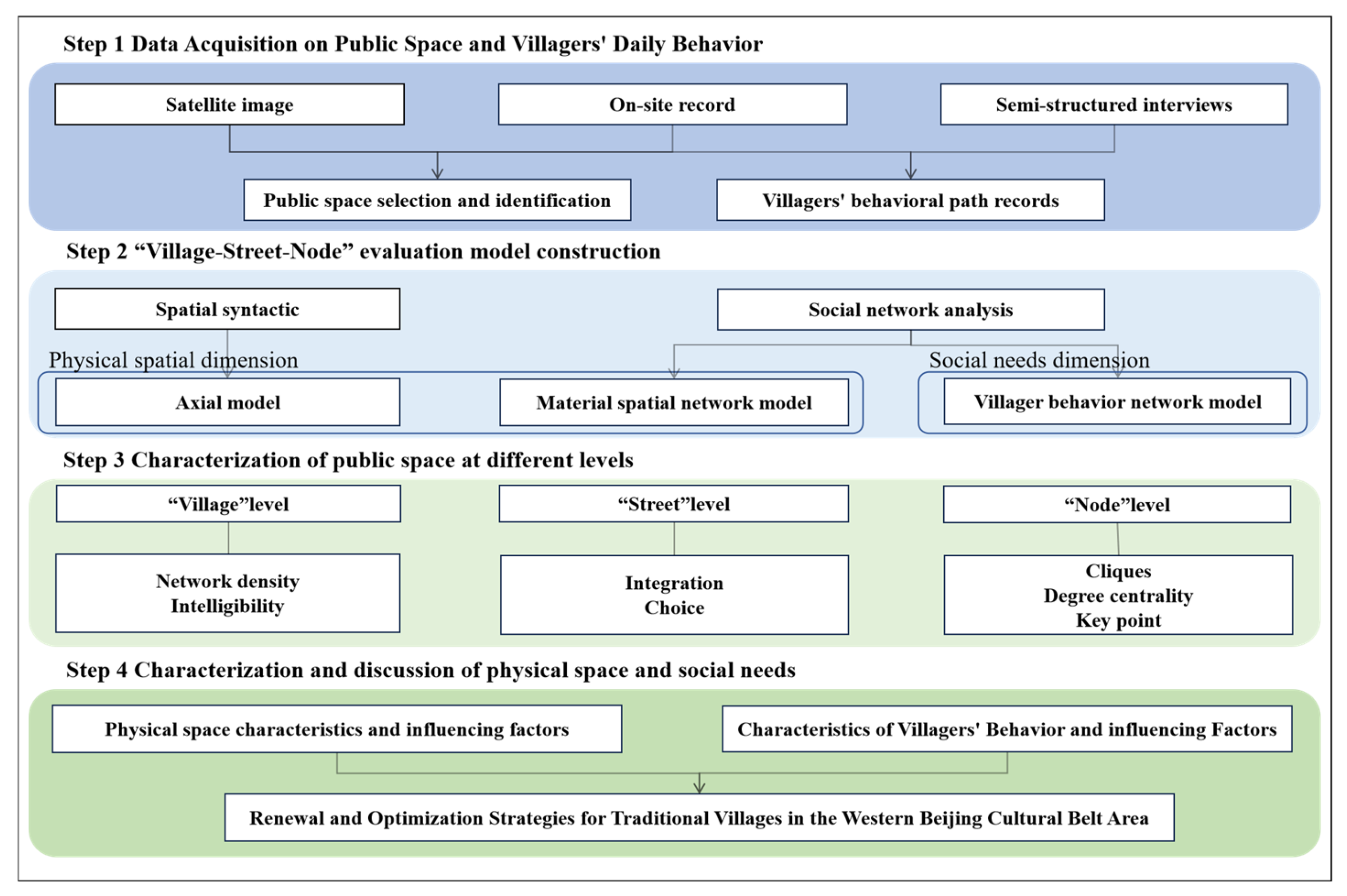
This study innovatively combines SNA and spatial syntax methods to investigate the public space structure of traditional villages in the Western Beijing Cultural Belt. The overall research framework, illustrated in Figure 4, consists of four main steps: (1) Select indicators for the public space characteristics of traditional villages through a review of literature and previous studies, incorporate insights from experts and scholars, and establish a three-tiered analysis system of “village–street–node.” (2) Collect village public space data and villager preference data through satellite images, questionnaire surveys, and fieldwork, and develop the axial model of spatial syntax, along with the material spatial network and villager behavior network models using SNA. (3) Use spatial syntax and social network models to examine the material spatial characteristics of traditional villages at various levels and the behavioral characteristics of villagers. (4) Compare the results across different models, conduct an in-depth analysis of the public space characteristics of traditional villages in the Western Beijing Cultural Belt, as well as the behavioral patterns of villagers and the factors influencing them, and propose targeted recommendations for the protection and renewal of traditional village spaces, focusing on balancing social needs with physical space.

2.3. Social Network Analysis

SNA has gained widespread use in architectural planning in recent years. As a quantitative analysis method that integrates sociology, statistics, and mathematics [37], SNA views the interrelationships between subjects as a structural network made up of nodes and connecting lines. It offers a quantitative tool for measuring sociological concepts that are otherwise difficult to quantify [42,43]. In this framework, the “nodes” typically represent actors, while the “lines” signify the causal connections or interactions between them [44,45]. In this paper, using SNA, the study treats the public space nodes in traditional villages as “points” and the interrelationships between these nodes and the villagers’ daily behavior paths as “lines” within the material spatial network and the villager behavior network, respectively. A binary relationship matrix is constructed to establish both the material spatial network model and the villager behavior network model. The study selects four indicators (Table 2)—network density, cliques, degree centrality, and key points—to analyze the objective material spatial patterns and the subjective usage needs of the villagers. The following section provides a description of the model formulas.

2.3.1. Network Density

Network density measures the overall completeness of the spatial network and the tightness of its connectivity. A higher network density value indicates a greater degree of connection between “points” in the network model, reflecting a more complete road network. The formula is as follows:
P = L n n 1 2
In the formula, P represents network density, L is the number of actual connections in the network, and n is the number of nodes present in the network.

2.3.2. Cliques

Cliques refer to well-connected subgraphs within a network model, where any two points within the subgraph are connected to each other, and there are no other points in the network model that are connected to all points in the sub-graph. They are used to characterize the local node distribution within the network.
In this study, the binary matrices constructed from the physical spatial network model and the villager’s behaviour network model were imported into the UCIENT6.0 software for clique classification.

2.3.3. Degree Centrality

In the material spatial network model, degree centrality measures the accessibility of spatial nodes; the higher the value, the greater the accessibility. In the villager behavior network model, degree centrality reflects the villagers’ preference for using spatial nodes; a higher value indicates more frequent use and greater preference for those nodes. The formula is as follows:
C n i = d n i n 1
In Equation, C(ni) represents the degree centrality of point ni, and d(ni) denotes the degree of point ni in a network of size n, indicating the number of points directly connected to ni.

2.3.4. Key Point

A key point is a crucial node in a network that facilitates communication between groups. If it collapses, the entire network system will disintegrate into several independent spatial groups. Therefore, key points are used to measure the stability and vulnerability of the network system. Fewer key points indicate higher stability in the network.

2.4. Spatial Syntax

Spatial syntax is a quantitative spatial analysis technique based on spatial grouping theory and the illustration of spatial relationships [46]. It can be divided into axial analysis, convex space analysis, and visual field analysis [34,47]. Axial analysis is commonly used in research on traditional village structures to explore factors influencing spatial layout, the characteristics of public spaces, and the evolution of spatial morphology [28,48,49]. In this study, axial analysis is applied to translate traditional village street spaces into an axial model, enabling the analysis of spatial morphology and structural characteristics of the streets. This approach addresses the limitations of SNA in studying the spatial characteristics of the “line” elements. The following section provides the model formula.

2.4.1. Intelligibility

Spatial intelligibility measures the degree of correlation between the local and the overall system, reflecting how easily the network can be understood. Higher spatial intelligibility indicates stronger continuity in the spatial interfaces of the system, making the space easier to comprehend and suggesting a more cohesive overall form. The spatial intelligibility, R2, is calculated as follows:
R 2 = ( I 3 I 3 · ( I n I n · ) I 3 I 3 · 2 I n I n · 2
In Equation, I ( 3 ) represents the global integration degree at step n = 3, while I ( 3 ) · denotes the average value of the three-step integration degree. I ( n ) refers to the global integration degree at step n, and I ( n ) · is the mean value of the global integration. The performance is classified as follows: R 2 < 0.5 , indicates average intelligibility performance; 0.5 R 2 0.7 , indicates good intelligibility performance; and 0.7 < R 2 indicates excellent intelligibility performance.

2.4.2. Integration

Integration is used to measure the accessibility of space and can be categorized into global integration and local integration. A higher integration value indicates stronger centrality, meaning greater potential for traffic and people gathering in that space. The formula is as follows:
I i = 2 1 n 1 i 1 n d i N d 1 n 2
Equation n represents the total number of axes or nodes within the spatial system; d i is the minimum number of connections from an axis to any other axis in the network; and N d denotes the number of connected axes.

2.4.3. Choice

The choice indicates the number of spatial connections between a space and other spaces and is used to measure the potential of a space to attract traffic. Higher choice values signify stronger spatial accessibility and greater frequency of use. The formula is as follows:
C = log 2 1 n 1 n 2 i = 1 n j n σ i , x , j + 1 log 2 i = 1 n d x , i + 3
Equation C represents the choice degree of the traditional village; i x j ; d x , i is the shortest distance from space x to i; σ i , x , j denotes the shortest path between x , i and j spaces.

2.5. Data Sources and Processing

2.5.1. Data Sources

The data used in this paper were sourced from three main areas: First, panoramic camera recordings were collected during three successive in-depth visits to Nanjiao, Heilongguan, and Shuiyu villages between August 2023 and April 2024. These recordings documented the internal spatial patterns and villagers’ behavioral paths. Second, in April 2024, with the coordination of the village committees of Nanjiao, Heilongguan, and Shuiyu villages, questionnaires and semi-structured interviews were conducted with 47 residents from Nanjiao, 26 residents from Heilongguan, and 40 residents from Shuiyu. These interviews, combined with previously collected spatial images, were conducted during the time slots of 8:00–10:00 and 13:00–14:00 to gather information on the villagers’ living spaces, daily activity areas, and public space nodes. As a result, 26 public space nodes in Nanjiao, 14 in Heilongguan, and 17 in Shuiyu were identified. Third, high-definition satellite remote sensing images of Nanjiao, Heilongguan, Shuiyu, and Liulinshui villages from 2024 were used.

2.5.2. Spatial Syntactic Axial Model

The study used CAD software to convert high-definition images of Nanjiao, Heilongguan, Liulinshui, and Shuiyu villages, collected via Google Earth, into spatial blocks, dividing the street organization within the settlements. The spatial structure was then represented with axes, transforming the settlement’s spatial organization into an axial map. Finally, the axial model was imported into the Depthmap platform for quantitative analysis of the morphology and characteristics of the built environment within the settlement.

2.5.3. Material Spatial Network Model

Combining field investigations with high-definition images of Nanjiao, Heilongguan, and Shuiyu villages collected via Google Earth, the study treats the existing 54 public space nodes as “points.” If a direct path exists between two points without detours or indirect connections through other points, a “line” is defined and assigned a value of “1”; otherwise, it is assigned a value of “0.” Given the unique characteristics of rural areas, which differ from urban settings, the semantic “point-line” model is modified. For this study, based on the small scale of the target villages, the walking distance for a “line” is adjusted from the standard 5-min walking distance (600 m) to a range more suitable for villagers walking patterns (70–120 m) [50]. A 1-min walking distance (120 m) serves as the basis for determining whether an interrelationship exists between points [8]. This establishes the binary relationship matrix, which is imported into the UCINET 6.0 platform, and the results are analyzed in NETDRAW software to construct the material spatial network model.

2.5.4. Villager Behavior Network Model

The study collects data on villagers’ daily behavioral paths and primary activity spaces through questionnaires, semi-structured interviews, and on-site observations. It defines spatial nodes where villagers frequently engage in daily activities as “points,” while direct movement paths between these “points” are defined as “lines.” If a “point” is merely passed through without stopping, no “line” is formed with the preceding or following nodes. If villagers are within a comfortable walking range (120 m) [50], the path between two points is assigned a value of “1”; otherwise, it is assigned a value of “0.” The resulting binary value matrix is imported into the UCINET 6.0 software for network structure calculations, and the results are then analyzed in NETDRAW software to construct the villager behavior network model.

3. Results

3.1. Characterization of Public Space at the Village Level

The dichotomous matrix was imported into UCINET software to calculate the network density of both the material spatial network and the villager behavior network for each village. The results revealed that the material spatial network densities for Nanjiao Village, Heilongguan Village, and Shuiyu Village were 0.1076, 0.1758, and 0.1471, respectively, indicating a low level of connectivity. This suggests that the public spatial structure in these villages is loosely organized, with insufficient connections between the nodes. Additionally, the behavior network density was lower than the spatial network density, with decreases of 28.5%, 31.2%, and 30% in Nanjiao Village, Heilongguan Village, and Shuiyu Village, respectively. This indicates that public space nodes are not being fully utilized by the villagers, leading to social segregation in all three villages. Nanjiao Village exhibited the smallest decrease, suggesting the highest utilization rate of public space nodes among the three traditional villages, while Heilongguan Village had the lowest utilization rate.
As illustrated in Table 3, the spatial intelligibility R2 of Nanjiao Village is 0.44661, of Heilongguan Village is 0.62026, and of Shuiyu Village is 0.287157. These values indicate that the continuity of the spatial interfaces of the streets and alleys in Heilongguan Village is stronger, while the continuity of the spatial interfaces in Nanjiao and Shuiyu Villages is less satisfactory.

3.2. Characterization of Public Space at the Street Level

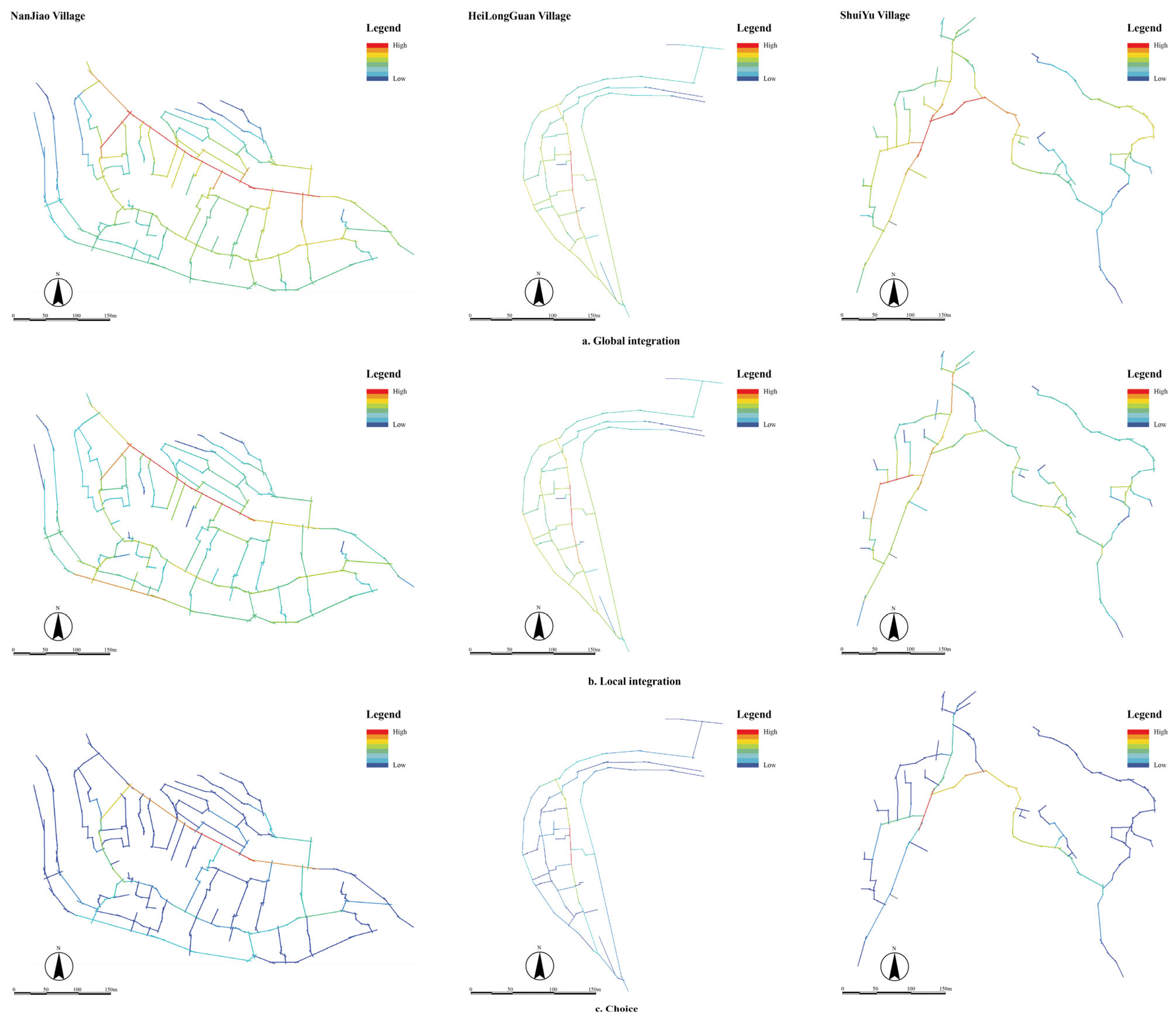
In the global integration map (Figure 5), all three villages exhibit distinct major and minor axes. Nanjiao Village and Heilongguan Village have well-connected streets and alleys, with highly accessible areas centrally distributed along the major and minor axes in a fishbone-like pattern, creating a belt-shaped spatial structure. In contrast, Shuiyu Village’s street network is more staggered, featuring sparse and short branch alleys. The main axis of Shuiyu Village does not exhibit the high integration characteristics seen in the other villages but instead shows significant centralization in localized areas.
By setting the axial topological radius (n) to 3, the axial map of the local integration degree is derived, reflecting the settlement’s ability to gather people (Figure 5). Heilongguan Village exhibits a simple spatial structure, where the global and local integration degrees align closely. In Nanjiao Village and Shuiyu Village, the local integration degree bears a notable similarity to the global integration degree. Specifically, in the southwestern part of Nanguo Village, the area around the Temple of the Goddess and the theatre (N9, N10, N24, N25, and N26), the area around the Cross-street towers and the old locust tree on the west side of Shuiyu Village (S2 and S5), and the area around the old locust tree and the gallery square in Heilongguan Village (H4 and H7), the local integration degree is significantly higher. This indicates that these spaces have a strong ability to concentrate pedestrian flow.
The choice graph (Figure 5) reveals that the main streets of Nanjiao Village and Heilongguan Village, as well as the street areas with high integration in Shuiyu Village, have significantly higher choice values. This includes the spatial connections of nodes related to key areas such as the villagers’ activity center, the village committee, and the fork in the village (N1, N2, and N5) in Nanjiao Village; the old locusts on the south side, the gallery square, and the old locusts on the north side (H4, H7, and H8) in Heilongguan Village; and the theater, public square, and cross-street towers on the east side (S1, S4, and S6) in Shuiyu Village. These prominent nodes reflect the strong connectivity between these spaces and their surrounding environments.

3.3. Characterization of Public Space at the Nodal Level

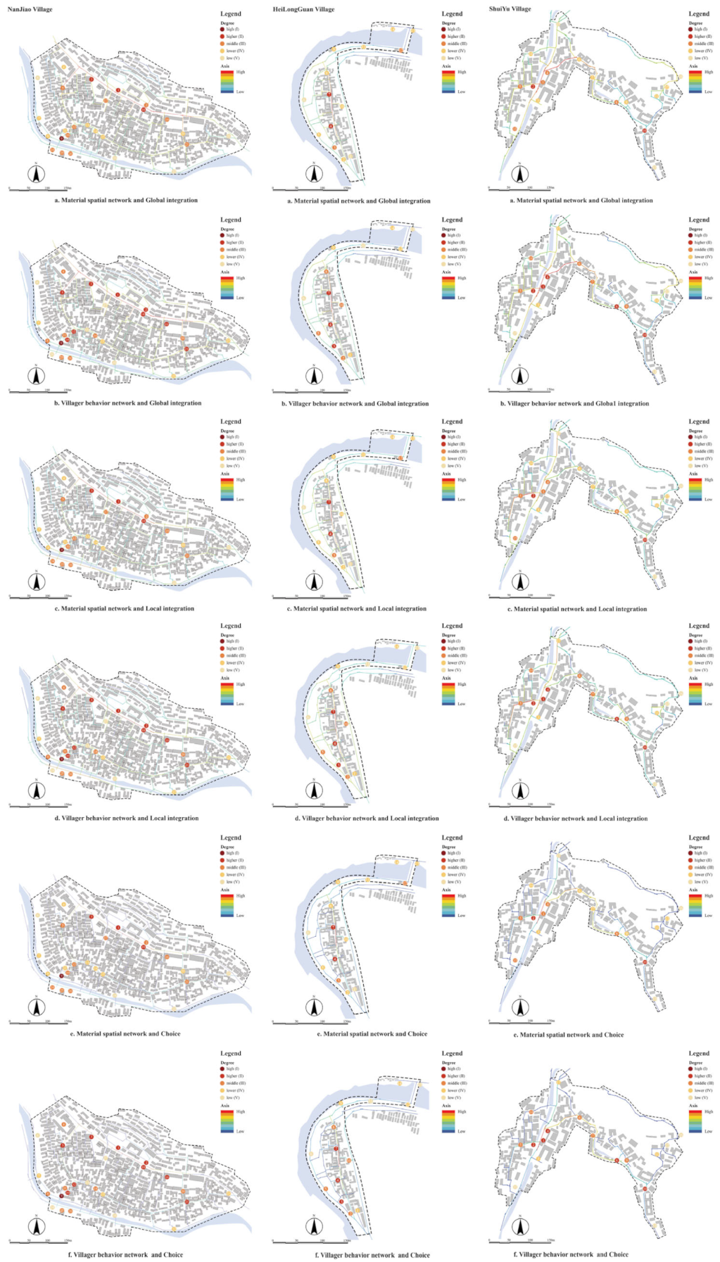
As seen from the results of the degree centrality calculations (Figure 6), most of the spatial nodes with high point degree centrality in the material spatial network and villager behavior network of the three traditional villages are coupled. The nodes with the highest degree of centrality are the theatrical platform in Nanjiao Village (N9), the old locust tree on the south side of Heilongguan Village (H4), the old locust tree in Shuiyu Village, and the Yang Family Compound (S2, S10), all of which are historical nodes. This indicates that historical nodes not only play a crucial role in the spatial structure of traditional villages in the Western Beijing Cultural Belt but also exhibit significant social attraction. Meanwhile, the point degree centrality of individual nodes in the material space (e.g., points N6, N13, N16, N17, N24, H6, H11, H13, L8, L15, L16, L17, S12, S13, S15, S16) is 0%, indicating social isolation within the villager behavior network. This reflects a misalignment between the material spatial network and the needs of the villagers in traditional villages in the Western Beijing Cultural Belt.
At least three spatial nodes are used as the division criteria for cliques, with strong spatial connections between nodes within cliques and weak cohesion among regional spatial nodes that do not form cliques. The division results are illustrated in Figure 7. The material spatial network of Nanjiao Village contains seven groups of cliques, five of which are distributed in the North Street area, while two are in the theatrical platform area (Figure 8). Compared with the material spatial network, the number of cliques in the North Street area has decreased, while the total number of cliques in the theatrical platform (N9) area remains unchanged. Both the material spatial networks of Heilongguan Village and Shuiyu Village contain three groups of cliques, with a decrease of one group in their respective behavioral network cliques. The distribution of both material and behavior network cliques shows that nodes in the main transportation areas are more likely to form cliques; however, the stability of these cliques in actual villagers’ social activities is weak. In contrast, spatial cliques formed in historical and cultural areas exhibit stronger stability in social activities. This suggests that villagers’ activities in the traditional villages of the Western Beijing region are more inclined towards historical and cultural spaces.
Further observation of the key points revealed that the proportion of material spatial network cut points in Nanjiao Village, Heilongguan Village, and Shuiyu Village were 50%, 57.1%, and 47%, respectively, while the rate of villager behavior network cut points were 52.3%, 63.6%, and 53.8%, respectively (Figure 6). This indicates a low degree of connectivity between the ancient street space and the surrounding street and alley spatial nodes, with a single path for internal behaviors. The internal spatial nodes tend to serve as the only and essential routes for villagers’ movements. For example, if a node in S7–S8 or S2–S3 on the main street of Heilongguan Village becomes congested or abandoned, the public space at both ends of the main street will be divided into two parts.

4. Discussion

4.1. Characteristics of Public Spaces in Traditional Villages in Western Beijing and Their Interaction with Villagers’ Spatial Behavior

A comprehensive comparison of the results from spatial syntax and SNA (Figure 9) reveals that the distribution of spatial nodes overlaps, with street spaces exhibiting high values of integration and choice. The settlement form is influenced by the natural landscape, with development centered around historical and cultural landmarks such as the Niangniang Temple, the theater, and the cross-street towers. Additionally, the village structure follows a belt-shaped, herringbone pattern, extending along the river or valley.
Further observation of the spatial nodes and the spatial conditions of their respective streets and alleys reveals that although the ancient streets of Nanjiao Village and the main streets of Heilongguan Village and Shuiyu Village possess favorable integration and choice, the internal spatial nodes fail to form effective connections. For example, no effective connection has been established between S5 and S6 in Heilongguan Village or between N15 and N21 in Nanjiao Village. This contradiction runs counter to their superior spatial potential. A 2024 spatial study on Nanjiao Village has shown that this issue stems from an insufficient number and uneven distribution of spatial nodes, resulting in excessive distances between them. Consequently, the service radius of these nodes is limited, leading to incomplete coverage of the ancient and main street spaces and an inability to form a fully integrated network [8].
It is worth noting that Shuiyu Village exhibits distinct characteristics in terms of global integration compared to the other two villages, with its main axis area showing no signs of high integration. This is due to the later construction of the main street intersecting with the ancient street, thereby weakening the spatial continuity of the ancient street. In contrast, the main streets and national highways constructed later in Nan Jiao Village and Hei Long Guan Village did not interfere with the texture of the ancient streets, thereby causing Shuiyu Village’s ancient street to lose its original spatial dominance within the settlement. This spatial impact caused by the later construction of the village is also reflected in the node network.
For example, under the influence of urbanization and tourism-driven development in traditional villages, the traditional architecture and courtyards in the historical settlements of the Jingxi region have undergone large-scale economic development during renovation and restoration processes. Newly constructed enclosed accommodations, restaurants, and courtyards have encroached upon the original street spaces, altering their morphological structure to varying degrees [41]. This has caused the connecting interfaces between areas such as N17 and S15 and other public spaces to become narrow, winding, and even interrupted, rendering them no longer able to draw the attention of users [51].
On the other hand, settlements contain spatial nodes such as N13 and S6, which exhibit high street and network accessibility yet still experience social isolation. This phenomenon diverges from the assumption proposed by Fang Q. and Meng S., who asserted that accessibility has the greatest impact on the quality of public spaces in traditional villages and more easily attracts villager activities [41,52]. This indicates that while the accessibility of spatial nodes is important, it is not the decisive factor in villagers’ daily choices of social spaces. This aligns with the conclusion drawn by Zhang C. and Shi Y. who noted that villagers in traditional settlements prioritize the social and functional attributes carried by spaces when selecting social spaces [53,54].
In previous research, Meng S’s quantitative study on the spatial elements of public spaces in traditional villages in western Beijing using machine learning revealed that spaces with the highest quality and strongest appeal and sense of identity for villagers were primarily concentrated near historical and cultural relics such as the Niangniang Temple, cross-street towers, and ancient trees [41]. Chen Y’s earlier study on the public spaces of Nanjiao Village also emphasized the dominant role of historical and cultural spaces in the public spaces of traditional villages in western Beijing [8]. However, in this study, the Dragon Temple (H14) in Heilongguan Village and the Spring Plaza (S13) in Shuiyu Village did not exhibit the expected clustering features in the physical spatial layout or villagers’ activities within the settlements. Instead, they displayed signs of social isolation, which contradicts previous conclusions. Analysis of the village layouts of Heilongguan and Shuiyu reveals that in increasingly hollowed-out traditional villages, houses within the settlements are gradually becoming abandoned, leading to a contraction in the actual inhabited area and the scope of villagers’ activities. As a result, historical and cultural spaces that once served as regional spatial nodes have gradually become marginalized within the settlements. Even though such nodes possess unique conditions to attract people, their excessive distance from the main settlement areas prevents them from fully realizing their spatial and cultural potential, leading to social isolation. Within the main settlements, areas of historical and cultural significance, such as the Niangniang Temple, the old locusts, and cross-street towers, continue to play a central role in the physical spatial structure of traditional villages in Beijing’s western cultural belt. These areas remain the most frequented venues for villagers’ daily activities.

4.2. Practical Implications

Based on the evaluation results from the case study area, this study proposes specific spatial planning and management strategies applicable to the Beijing Western Cultural Belt and other similar regions facing severe challenges in the protection and renewal of traditional villages.
At the village scale, the findings reveal that Nanjiao Village and Shuiyu Village exhibit weak street continuity. This aligns with the actual situation, as their street spaces have been impacted by government-led development and self-built activities by villagers during urbanization and tourism development. This has led to insufficient connections between public space nodes and low utilization rates, resulting from compressed, fragmented, and disconnected street spaces. In contrast, Heilongguan Village, which demonstrates the strongest spatial continuity, suffers from severe hollowing out and shrinkage of settlement space, leading to low utilization of public areas. Therefore, it is essential to delineate cultural preservation zones and daily living zones based on each village’s historical evolution, resource conditions, spatial potential of public spaces, and villagers’ activity preferences. This approach balances heritage conservation with development, ensuring targeted and practical spatial planning and resource allocation to meet the growing material and cultural needs of villagers.
At the street and alley scale, the results indicate that traditional villages face a misalignment between the potential of public spaces and social demands due to reduced spatial choice caused by tourism-oriented development. Thus, leveraging the historical fabric and resource distribution of the villages, it is necessary to further standardize spatial conservation regulations in a top-down manner. Within cultural preservation zones, measures such as clearing and reclaiming spaces should be implemented to restore the spatial fabric. In daily living zones, villager-led governance models, such as the “street chief system,” should be introduced to foster villagers’ sense of ownership in maintaining the street environment. Additionally, establishing clear guided tour routes within cultural preservation zones can enhance the continuity and directional flow of spatial interfaces in traditional villages, effectively connecting various spatial nodes. This will strengthen the cohesion between core nodes and surrounding areas, improving connectivity and ultimately forming more vibrant and attractive thematic node clusters.
At the node scale, the findings show that while accessibility determines the capacity of public spaces to attract crowds, it is not the decisive factor for villagers’ social activities. Attributes such as functionality, culture, and history are crucial in determining the usability of nodes. Therefore, landscape design elements that reflect the unique character of the region can be integrated to enrich node functions—providing spaces for rest, recreation, cultural exchange, and social interaction—while enhancing comfort and appeal. To address uneven node distribution and low utilization, movable modular design installations can be introduced to strengthen the use of small-scale, daily public spaces, such as street corners, alleys, and areas around houses.

4.3. Limitations

Although this paper couples SNA and spatial syntax to study the public space structure from the perspective of the indigenous people, focusing on the interaction between street space, public space nodes, and villagers’ social activities, both methods are limited by their topological representation of space, ignoring its morphological characteristics and the influence of spatial elements such as terrain, altitude, and enclosure degree. This prevents the identification of specific factors affecting the use of public spaces. Additionally, field data collection, street mapping information, and historical planning data. The modeling of material space is also affected by the accuracy of satellite imagery, particularly when addressing internally encroached street spaces, leading to errors in material space modeling. Additionally, the quantitative research and analysis of motivational factors remain insufficient. In addition, since most of the resident villagers interviewed were middle-aged and elderly individuals over 50 years old, the study could not fully capture the daily behavioral trajectories of villagers across all age groups. This limitation affected the comprehensive study of the interaction between material spatial and behavioral networks. Future research should expand the scope and precision of the study population, reduce model errors by integrating historical images, planning data, and aerial images captured by drones, and better understand the needs and expectations of various groups, such as villagers and tourists, regarding traditional village spaces. This can be achieved by combining big data and participatory mapping. The goal is to provide a precise optimization of historical heritage spaces for multiple space users and establish a feedback mechanism for the configuration of spatial resources, promoting efficient allocation. Ultimately, this approach will support green planning, green construction, and sustainable development in traditional villages while enhancing their spatial resilience.

5. Conclusions

To address the issue of mismatch between spatial resource allocation and social needs during the evolution of traditional villages, this study takes traditional villages in Fangshan District, Beijing, as its research subject. By combining axis analysis from spatial syntax with social network analysis (SNA), this study visually presents and systematically compares the physical spatial characteristics of three villages with the social spatial preferences of their indigenous residents. From the perspective of local residents, it reveals the interactive mechanisms between public space nodes and their surrounding neighbourhood networks, providing valuable insights for the precise optimisation and sustainable development of traditional villages. Key findings include:
(1) In the traditional villages of the Beijing Western Cultural Belt region, public spaces are primarily characterized by historic public spaces such as the Niangniang Temple, opera stages, and ancient locusts serving as cores. The main streets typically follow linear, belt-like distributions along valleys or mountain slopes, with branch alleys extending outward in a fishbone-like pattern. This understanding will assist local governments in clarifying settlement textures and identifying core conservation zones during the renewal process of traditional villages in western Beijing.
(2) Research validation demonstrates that while historic public spaces within settlements function as focal points for both the physical space and daily activities in traditional villages, those affected by village spatial contraction and located on the periphery suffer from low utilization rates among villagers and even exhibit social isolation. This finding will help governments develop more targeted classification-based optimization and conservation policies during traditional village preservation efforts.
(3) The study indicates that within public spaces located inside traditional villages, deficiencies in alleyway space choice, intermediary nodes within the nodal network, and the functional capacity of the nodes themselves are also key factors contributing to social isolation in public spaces. This insight will assist governments in addressing the most prominent issues and shortcomings of public spaces.
Furthermore, the study integrates space syntax with social network analysis to reveal the spatial-social relationships in traditional villages of Beijing’s Fangshan District, thereby constructing a dual-dimensional analytical framework of “space-society” that can be applied across cultures and regions. This provides empirical cases for international research on traditional villages. The study not only highlights the universal phenomenon that historical public spaces may trigger social isolation in the context of village shrinkage but also emphasizes the critical role of node connectivity, the cultivation of intermediate functional nodes, and the quality improvement of small-scale spaces in public space governance. These findings offer valuable insights for the renewal of traditional villages in East Asia and globally that face similar challenges such as population decline, aging, and spatial decay. They particularly provide theoretical foundations and practical pathways for developing countries to balance spatial preservation and social integration in rural sustainable development.

Author Contributions

Y.C.: Conceptualization, Methodology, Investigation, Visualization, Writing—Original draft. Y.X. and C.X.: Software, Visualization. Formal analysis. S.M. and C.L.: Writing—Review and Editing. Y.Z.: Review and Editing, Supervision. All authors have read and agreed to the published version of the manuscript.

Funding

This work was supported by the Research Foundation from Ministry of Education of China (No. 23YJA760118), and China National Key Research and Development Plan Program (No. 2024YFD2200900).

Institutional Review Board Statement

The study was conducted in accordance with the Declaration of Helsinki and obtained formal ethics approval from Beijing Forestry University Human Research Ethics Committee (Approval No. BJFUPSY-2025-038) on 27 May 2025. The study did not involve the collection of data that could identify participants. All information was anonymized and did not contain any personally identifiable details.

Informed Consent Statement

Informed consent was obtained from all participants involved in this study. In April 2024, with the assistance and witness of the village committee, all participants were informed in writing of the purpose of the study, the research process, potential risks and benefits, data confidentiality measures, and the contact information of the researchers and the Human Study Ethics Committee of Beijing Forestry University. Participants were informed in the consent form that the survey was anonymous, their participation was entirely voluntary, and they had the right to withdraw from the survey at any time without providing any reason. Additionally, all information provided would be stored anonymously and securely.

Data Availability Statement

The datasets generated and analyzed during the current study are available from the corresponding author upon reasonable request.

Acknowledgments

The authors express their sincere gratitude to the interviewees for their valuable participation and patience throughout this process.

Conflicts of Interest

The authors declare no conflicts of interest.

References

  1. Wang, X.; Zhu, X.; Tang, P. Interpreting and Reconstructing the Characteristics of Traditional Chinese Villages: A Method of Cognition and Utilization Based on Clustering and Knowledge Graph. Archit. J. Jian Zhu Xue Bao 2025, 4, 82–89. [Google Scholar]
  2. Sardaro, R.; La Sala, P.; De Pascale, G.; Faccilongo, N. The conservation of cultural heritage in rural areas: Stakeholder preferences regarding historical rural buildings in Apulia, southern Italy. Land Use Policy 2021, 109, 105662. [Google Scholar] [CrossRef]
  3. Chenge, G.; Fang, W. Syntactic Analysis of Spatial Structure Characteristics of Traditional Villages Along the Yellow River in Western Shanxi Province. Landsc. Archit. 2025, 32, 116–124. [Google Scholar]
  4. Zheng, X.; Sun, C.; Liu, J. Exploring stakeholder engagement in urban village renovation projects through a mixed-method approach to social network analysis: A case study of Tianjin. Humanit. Soc. Sci. Commun. 2024, 11, 27. [Google Scholar] [CrossRef]
  5. Tao, G.; Li, X.; Tian, S.; Li, H.; Song, Y. Influence of human settlements factors on the spatial distribution patterns of traditional villages in Liaoning province. Humanit. Soc. Sci. Commun. 2024, 11, 1757. [Google Scholar] [CrossRef]
  6. Lekakis, S.; Dragouni, M. Heritage in the making: Rural heritage and its mnemeiosis at Naxos island, Greece. J. Rural. Stud. 2020, 77, 84–92. [Google Scholar] [CrossRef]
  7. Gao, J.; Wu, B. Revitalizing traditional villages through rural tourism: A case study of Yuanjia Village, Shaanxi Province, China. Tour. Manag. 2017, 63, 223–233. [Google Scholar] [CrossRef]
  8. Yuke, C.; Shiyu, M. Optimizing public space structure of traditional villages coupling SNA and spatial syntax. Trans. Chin. Soc. Agric. Eng. 2024, 40, 304–314. [Google Scholar]
  9. Ma, W.; Mu, L. China’s rural revitalization strategy: Sustainable development, welfare, and poverty alleviation. Soc. Indic. Res. 2024, 174, 743–767. [Google Scholar] [CrossRef]
  10. Zhu, Q.; Liu, S. Spatial morphological characteristics and evolution of traditional villages in the mountainous area of Southwest Zhejiang. Isprs Int. J. Geo. Inf. 2023, 12, 317. [Google Scholar] [CrossRef]
  11. Liu, Y.; Li, Y. Revitalize the world’s countryside. Nature 2017, 548, 275–277. [Google Scholar] [CrossRef] [PubMed]
  12. Qi, W.; Deng, Y.; Fu, B. Rural attraction: The spatial pattern and driving factors of China’s rural in-migration. J. Rural. Stud. 2022, 93, 461–470. [Google Scholar] [CrossRef]
  13. Jiang, Y.; Li, N.; Wang, Z. Parametric reconstruction of traditional village morphology based on the space gene perspective—The case study of Xiaoxi Village in Western Hunan, China. Sustainability 2023, 15, 2088. [Google Scholar] [CrossRef]
  14. Lefebvre, H. The Production of Space; Blackwell: Oxford, UK, 1991. [Google Scholar]
  15. Qiu, Z.; Wang, Y.; Bao, L.; Yun, B.; Lu, J. Sustainability of Chinese village development in a new perspective: Planning principle of rural public service facilities based on “Function-Space” synergistic mechanism. Sustainability 2022, 14, 8544. [Google Scholar] [CrossRef]
  16. Yu, G.L.; Ma, L.H. Governance Embedded in Life: Research into the Realisation Path of Rural Public Life Governance in Metropolitan Suburbs. J. Nanjing Agric. Univ. (Soc. Sci. Ed.) 2024, 24, 149–160. [Google Scholar] [CrossRef]
  17. Xv, R.F.; Gao, M.Y.; Xv, Y.J.; Zhou, Z.X. Cultural characteristics of rural public spaces and implications for cultural governance: A case study of Dong Villages in Southeast Guizhou Province. J. Hum. Settl. West China 2024, 39, 23–28+67. [Google Scholar] [CrossRef]
  18. Qu, Y.; Jiang, G.; Zhao, Q.; Ma, W.; Zhang, R.; Yang, Y. Geographic identification, spatial differentiation, and formation mechanism of multifunction of rural settlements: A case study of 804 typical villages in Shandong Province, China. J. Clean. Prod. 2017, 166, 1202–1215. [Google Scholar] [CrossRef]
  19. Shi, Z.; Ma, L.; Zhang, W.; Gong, M. Differentiation and correlation of spatial pattern and multifunction in rural settlements considering topographic gradients: Evidence from Loess Hilly Region, China. J. Environ. Manag. 2022, 315, 115127. [Google Scholar] [CrossRef]
  20. Li, Y.; Liu, Y.; Long, H.; Cui, W. Community-based rural residential land consolidation and allocation can help to revitalize hollowed villages in traditional agricultural areas of China: Evidence from Dancheng County, Henan Province. Land Use Policy 2014, 39, 188–198. [Google Scholar] [CrossRef]
  21. Chen, R.; Ye, C.; Cai, Y.; Xing, X.; Chen, Q. The impact of rural out-migration on land use transition in China: Past, present and trend. Land Use Policy 2014, 40, 101–110. [Google Scholar] [CrossRef]
  22. Long, Z.K.; Zhang, Z.S. Analysis of Spatial Distribution Characteristics of Rural Settlements in Town Areas Based on GIS: A Case Study of Jianggao Town, Guangzhou City. City Geogr. 2016, 28–30. [Google Scholar]
  23. Chen, Y.L.; Xie, B.G. The spatial evolution and restructuring of rural settlements in Jiangnan hilly region: A case study in South Jiangxi. Geogr. Res. 2016, 35, 184–194. [Google Scholar]
  24. Wang, J.; Sun, Q.; Zou, L. Spatial-temporal evolution and driving mechanism of rural production-living-ecological space in Pingtan islands, China. Habitat Int. 2023, 137, 102833. [Google Scholar] [CrossRef]
  25. Wang, Z.; Ou, L.; Chen, M. Evolution characteristics, drivers and trends of rural residential land in mountainous economic circle: A case study of Chengdu-Chongqing area, China. Ecol. Indic. 2023, 154, 110585. [Google Scholar] [CrossRef]
  26. Geng, B.; Tian, Y.; Zhang, L.; Chen, B. Evolution and its driving forces of rural settlements along the roadsides in the northeast of Jianghan Plain, China. Land Use Policy 2023, 129, 106658. [Google Scholar] [CrossRef]
  27. Liu, J.B.; Yi, M.H.; Du, X.; Zhao, H.; Ma, Z.P. Spatial reconstruction of rural settlements oriented towards agricultural and rural modernization in China. Geogr. Sci. 2025, 45, 326–338. [Google Scholar] [CrossRef]
  28. Wang, X.; Zhu, R.; Che, B. Spatial optimization of tourist-oriented villages by space syntax based on population analysis. Sustainability 2022, 14, 11260. [Google Scholar] [CrossRef]
  29. Wang, M.; Liu, J.; Zhang, S.; Zhu, H.; Zhang, X. Spatial pattern and micro-location rules of tourism businesses in historic towns: A case study of Pingyao, China. J. Destin. Mark. Manag. 2022, 25, 100721. [Google Scholar] [CrossRef]
  30. Statuto, D.; Cillis, G.; Picuno, P. GIS-based analysis of temporal evolution of rural landscape: A case study in Southern Italy. Nat. Resour. Res. 2019, 28, 61–75. [Google Scholar] [CrossRef]
  31. Ma, Y.; Zhang, Q.; Huang, L. Spatial distribution characteristics and influencing factors of traditional villages in Fujian Province, China. Humanit. Soc. Sci. Commun. 2023, 10, 883. [Google Scholar] [CrossRef]
  32. Zhang, Y.; Li, Y. Spatial evolution and spatial production of traditional villages from “backward poverty villages” to “ecologically well-off villages”: Experiences from the hinterland of national nature reserves in China. J. Mt. Sci. 2024, 21, 1100–1118. [Google Scholar] [CrossRef]
  33. Zhao, Y.; Xiang, H.; Huang, Z. Architectural spatial distribution and network connectivity characteristics of ancient military towns in Southwest China: A case study of Qingyan Ancient Town in Guiyang. Herit. Sci. 2024, 12, 403. [Google Scholar] [CrossRef]
  34. Lin, Z.; Liang, Y.; Liu, X. Study on spatial form evolution of traditional villages in Jiuguan under the influence of historic transportation network. Herit. Sci. 2024, 12, 29. [Google Scholar] [CrossRef]
  35. Bassi, I.; Zaccarin, S.; De Stefano, D. Rural inter-firm networks as basis for multifunctional local system development: Evidence from an Italian alpine area. Land Use Policy 2014, 38, 70–79. [Google Scholar] [CrossRef]
  36. Xia, H.; Li, C.; Zhou, D.; Zhang, Y.; Xu, J. Peasant households’ land use decision-making analysis using social network analysis: A case of Tantou Village, China. J. Rural. Stud. 2020, 80, 452–468. [Google Scholar] [CrossRef]
  37. Lin, G.; Yu, X.; Li, Y. Social network dynamics in rural public spaces of multi-ethnic settlements: A case study from Tongren, China. Alex. Eng. J. 2024, 102, 132–148. [Google Scholar] [CrossRef]
  38. Xiang, H.; Xie, M.; Fang, Y. Study on the architecture space-social network characteristics based on social network analysis: A case study of Anshun Tunpu settlement. Ain Shams Eng. J. 2024, 15, 102333. [Google Scholar] [CrossRef]
  39. He, Y.; Wang, X.; He, Y.; Duan, Z.; Zeng, G. The revival and reconstruction of traditional rural public cultural space under the perspective of rural revitalization: A survey based on the ancestral halls in villages in Lianhua County, Jiangxi Province. J. Agric. For. Econ. Manag 2019, 18, 822–828. [Google Scholar]
  40. Wang, Y.; Meng, X.; Zou, Q. The pattern language and its application in public open space in traditional village. Chin. Landsc. Archit. 2016, 32, 44–49. [Google Scholar]
  41. Meng, S.; Liu, C.; Zeng, Y.; Xu, R.; Zhang, C.; Chen, Y.; Wang, K.; Zhang, Y. Quality Evaluation of Public Spaces in Traditional Villages: A Study Using Deep Learning and Panoramic Images. Land 2024, 13, 1584. [Google Scholar] [CrossRef]
  42. Lee, D. Actors, the actor network and their impact on public space management: Social network analysis as a method. Raumforsch. Und Raumordn. Spat. Res. Plan. 2023, 81, 373–387. [Google Scholar] [CrossRef]
  43. Poveda-Bautista, R.; Gonzalez-Urango, H.; Ramírez-Olivares, E.; Diego-Mas, J.-A. Engaging Stakeholders in Extraction Problems of the Chilean Mining Industry through a Combined Social Network Analysis-Analytic Network Process Approach. Complexity 2022, 2022, 9096744. [Google Scholar] [CrossRef]
  44. Shi, Y. Research on the Social Structure Evolution of Historical and Cultural Villages and Towns in Southwest Mountain Areas. Ph.D. Thesis, Chongqing University, Chongqing, China, 2021. [Google Scholar]
  45. Scott, J. What is social network analysis? Bloomsbury Academic: New York, NY, USA, 2012. [Google Scholar]
  46. Koohsari, M.J.; Kaczynski, A.T.; Mcormack, G.R.; Sugiyama, T. Using Space Syntax to Assess the Built Environment for Physical Activity: Applications to Research on Parks and Public Open Spaces. Leisure Sciences 2014, 36, 206–216. [Google Scholar] [CrossRef]
  47. Askarizad, R.; Lamíquiz Daudén, P.J.; Garau, C. The Application of Space Syntax to Enhance Sociability in Public Urban Spaces: A Systematic Review. ISPRS Int. J. Geo. Inf. 2024, 13, 227. [Google Scholar] [CrossRef]
  48. Xiao, H.; Xue, C.; Yu, J.; Yu, C.; Peng, G. Spatial Morphological Characteristics of Ethnic Villages in the Dadu River Basin, a Sino-Tibetan Area of Sichuan, China. Land 2023, 12, 1662. [Google Scholar] [CrossRef]
  49. Qin, X.; Du, X.; Wang, Y.; Liu, L. Spatial evolution analysis and spatial optimization strategy of rural tourism based on spatial syntax model—A case study of Matao Village in Shandong Province, China. Land 2023, 12, 317. [Google Scholar] [CrossRef]
  50. Du, C.; Shou, J. Harmonized design of rural density and living quality: Songjiang District, Shanghai. Planners 2020, 36, 67–72. [Google Scholar]
  51. Al Mushayt, N.S.; Cin, F.D.; Barreiros Proença, S. New lens to reveal the street interface. A morphological-visual perception methodological contribution for decoding the public/private edge of arterial streets. Sustainability 2021, 13, 11442. [Google Scholar] [CrossRef]
  52. Fang, Q.L.; Zhu, Y. Study on Optimization of Public Space in Huizhou Traditional Villages from the Perspective of Behavioral Demand. Forecasting 2021, 6, 90–96. [Google Scholar]
  53. Shi, Y.L. Evolution of Social Structure of Historicaland Cultural Villages and Towns in theMountainous Southwest China. Ph.D. Thesis, Chongqing University, Chongqing, China, 2021. [Google Scholar]
  54. Zhang, C.Y.; Meng, S.Y.; Zhang, H.W.; Zhang, Y.L. Evaluation of Villagers’Satisfaction to Public Spaces in Traditional Villages and Identification of Obstacle Factors:A Case Study Based on Nanjiao Village in Beijing. South Archit. 2025, 50–61. [Google Scholar]
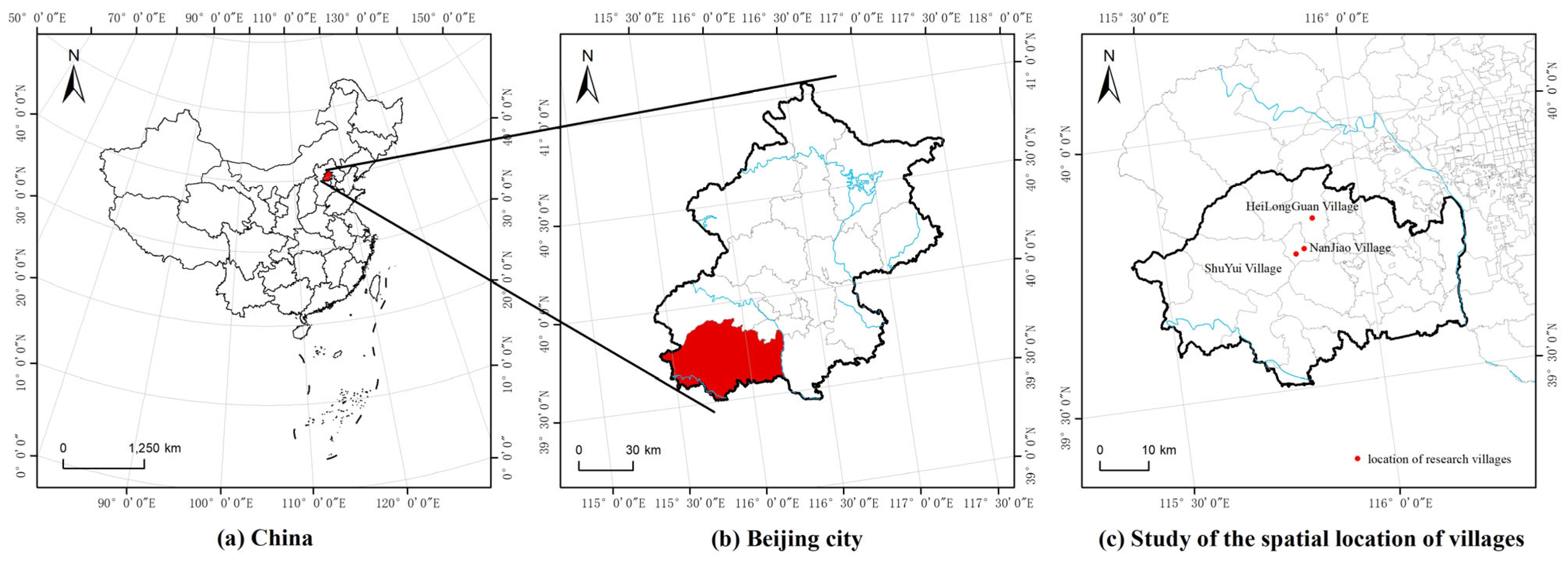
Figure 1. Study area.
Land 14 01982 g001
Figure 2. Node type diagram.
Land 14 01982 g002
Figure 3. Node distribution map.
Land 14 01982 g003
Figure 4. Method framework.
Land 14 01982 g004
Figure 5. Linear public space Integration and Choice analysis chart. (Note: In figure (a) Gobal Integration and (b) Local Integration, the more red the color of the axis, the stronger the spatial concentration and higher the traffic volume; in figure (c) Choice, the more red the color of the axis, the greater the potential for attracting passing traffic).
Land 14 01982 g005
Figure 6. Chart of degree centrality and key points.
Land 14 01982 g006
Figure 7. Cliques’ distribution.
Land 14 01982 g007
Figure 8. Cliques’ distribution map.
Land 14 01982 g008
Figure 9. Overlay of spatial syntax and social network analysis.
Land 14 01982 g009
Table 1. Basic attributes of public space sample points.
NoNameTypeNoNameTypeNoNameType
N1Villagers’ activity squarefunctional typeN20East entrance of the schoolfunctional typeH13Open space by the bridgefunctional type
N2Village committeefunctional typeN21Xuan Di Templehistoric typeH14Dragon Templehistoric type
N3Village entranceliving typeN22Riverside parking lotfunctional typeS1Theaterhistoric type
N4Health centerfunctional typeN23East side old locustshistoric typeS2Old locustshistoric type
N5Fork in the villageliving typeN24A plank roadfunctional typeS3Village committeefunctional type
N6Riverside Greenfunctional typeN25Theaterhistoric typeS4Public squarefunctional type
N7Footbridgefunctional typeN26Parking lot on the south bank of the riverfunctional typeS5Cross-street towers (west)historic type
N8Parking lot on the north bank of the riverfunctional typeH1Village committeefunctional typeS6Cross-street towers (east)historic type
N9Theatrical platformhistoric typeH2Parking lotsfunctional typeS7Footbridgeliving type
N10Cross-street towershistoric typeH3Public squarefunctional typeS8Niangniang Temple Squarehistoric type
N11Niangniang templehistoric typeH4Southside old locustshistoric typeS9Niangniang Templehistoric type
N12Old locusthistoric typeH5Riverside green space 1functional typeS10Yang family compoundhistoric type
N13Entrance to the ancient streetliving typeH6Riverside Green Space 2functional typeS11Altarhistoric type
N14Fitness squarefunctional typeH7Gallery Squarehistoric typeS12Village ruinshistoric type
N15Vacant lot in front of the houseliving typeH8Northside old locustshistoric typeS13Spring Plazahistoric type
N16Riverside open spaceliving typeH9Pavilionhistoric typeS14Senior centerfunctional type
N17Open space in the villageliving typeH10Entrance Plazafunctional typeS15Open space in the villageliving type
N18Kiosksfunctional typeH11Riverwalkfunctional typeS16Plank roadhistoric type
N19West entrance of the schoolfunctional typeH12Parking lot by the bridgefunctional typeS17Entrance Plazafunctional type
(Note: NX denotes node X of Nanjiao Village, HX stands for node X of Heilongguan Village, and SX denotes node X of Shuiyu Village).
Table 2. “Village–Street–Node” evaluation indicators.
LevelIndicatorIndicator Interpretation
VillageNetwork densityMeasurement of overall network completeness
IntelligibilityMeasuring the degree to which the local is relevant to the global
StreetsIntegrationMeasuring the transportation potential of a space to attract arrivals
ChoiceMeasuring the potential of space to attract through traffic
NodesCliquesMeasuring the characteristics of node distribution in a localized region
Degree centralitySpatial networks: measuring the accessibility of nodes
Behavior networks: measuring villager use of nodes
Key pointMeasuring the importance of nodes and the stability of the network
Table 3. Results of the analysis of village area indicators.
IndicatorNanjiao VillageHilongguan VillageShuiyu Village
Material spatial
network density
0.10760.17580.1471
Villager behavior
network density
0.07690.12090.1029
Intelligibility0.446610.620260.287157
Disclaimer/Publisher’s Note: The statements, opinions and data contained in all publications are solely those of the individual author(s) and contributor(s) and not of MDPI and/or the editor(s). MDPI and/or the editor(s) disclaim responsibility for any injury to people or property resulting from any ideas, methods, instructions or products referred to in the content.