
Construction of Ecological Security Patterns and Evaluation of Ecological Network Stability under Multi-Scenario Simulation: A Case Study in Desert–Oasis Area of the Yellow River Basin, China

Abstract
1. Introduction
2. Materials and Methods
2.1. Study Area and Data
2.1.1. Study Area
2.1.2. Data Sources and Processing
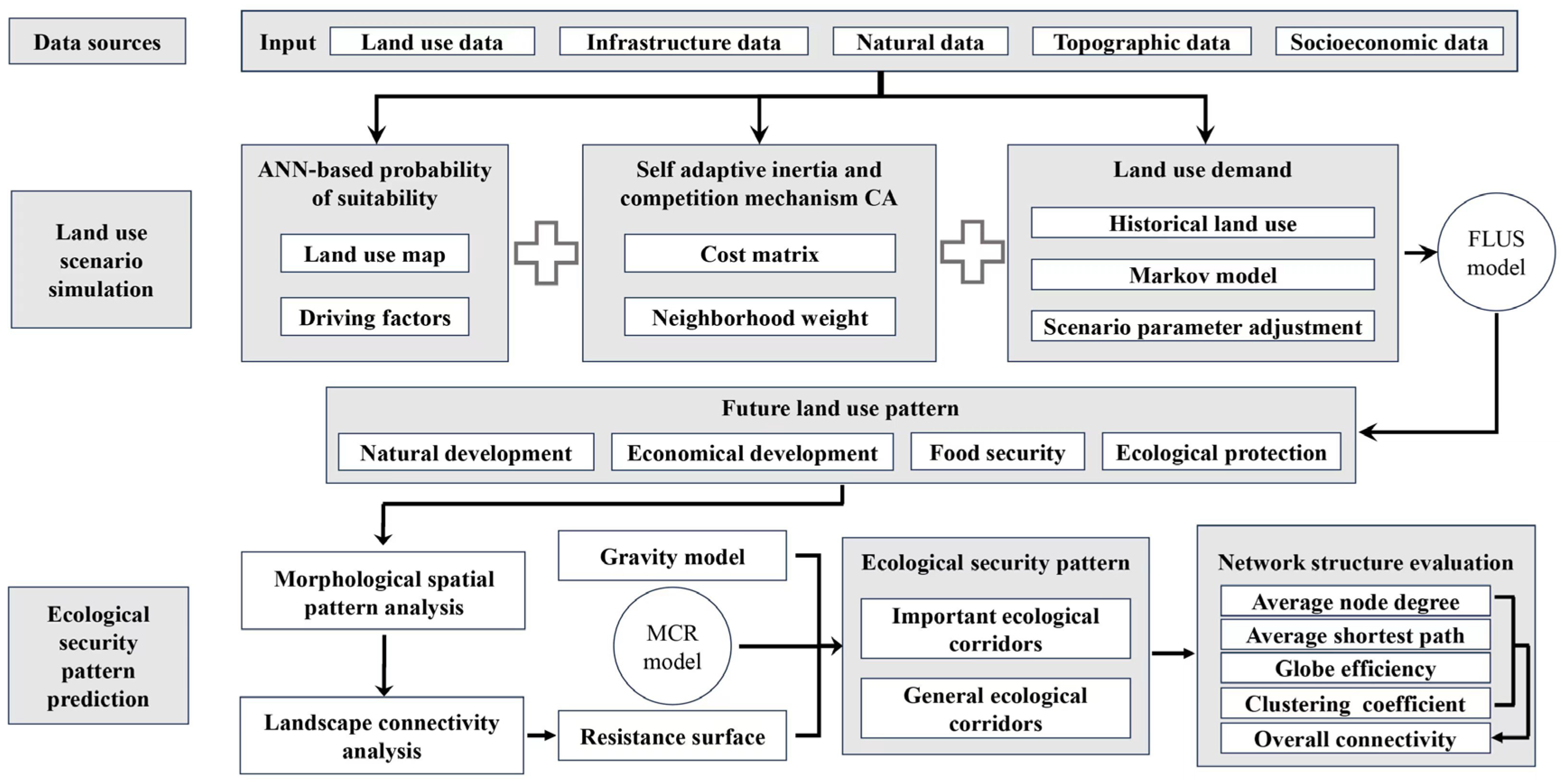
2.2. Methods
2.2.1. Land Use Simulation under Multiple Scenarios
Transition Probability of Land Use Change
FLUS Models’ Parameter Setting
Forecasting Land Use Demand under Multiple Scenarios
Model Validation
2.2.2. ESP Construction
Ecological Source Identification
Resistance Surface Establishment
Ecological Corridor Extraction
2.2.3. ESPs Stability Evaluation
3. Results
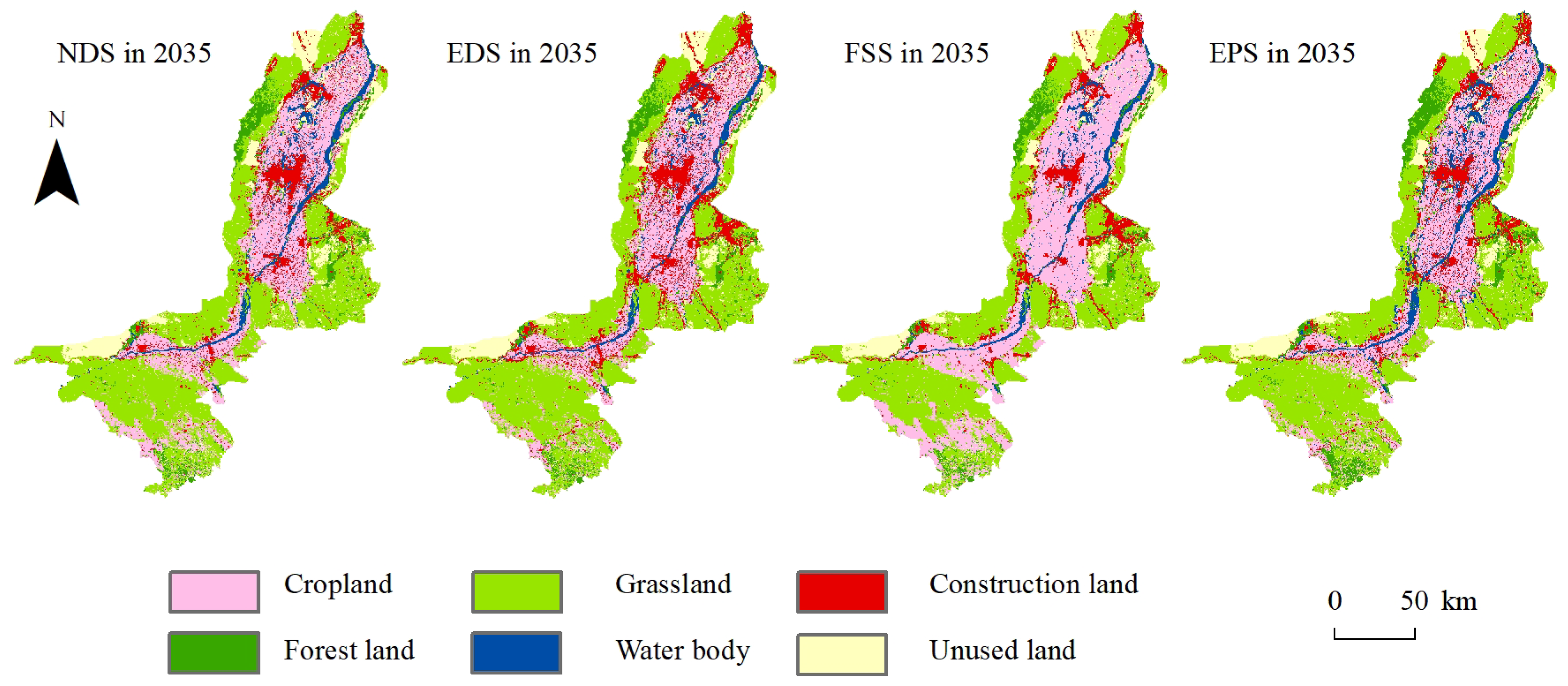
3.1. Land Use Simulation under Multiple Scenarios
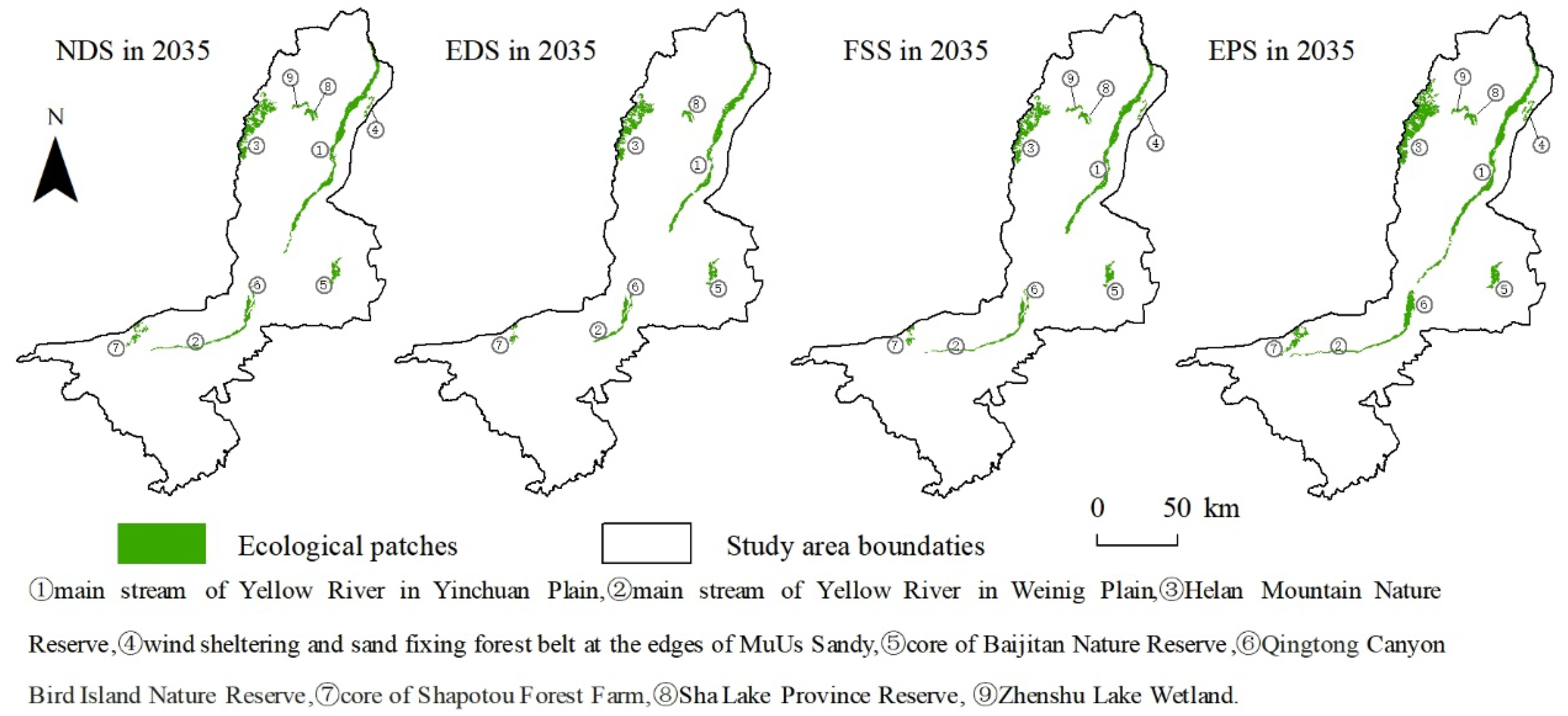
3.2. ESP Identification
3.2.1. Ecological Sources
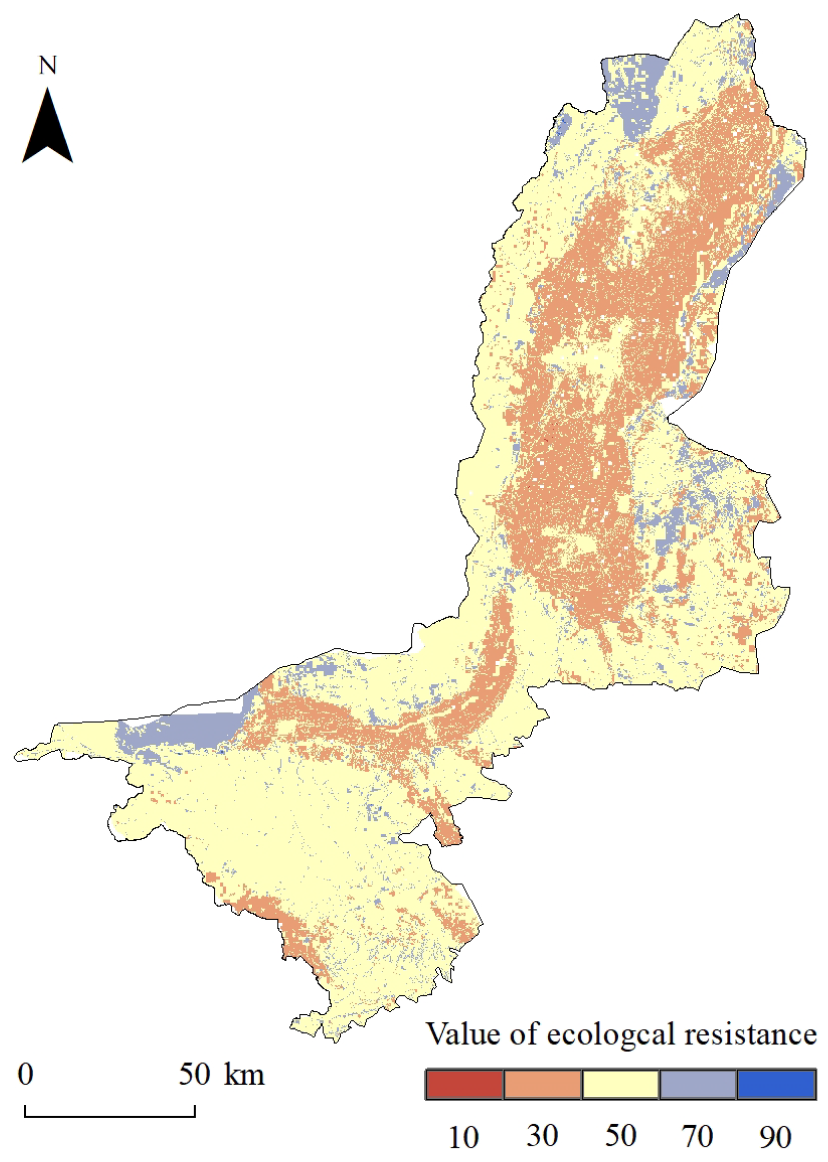
3.2.2. Ecological Resistance
3.2.3. Ecological Corridors
3.3. Evaluation of Network Stability of ESPs
4. Discussion
4.1. Necessity of Simulating Future ESPs under Multiple Scenarios
4.2. Proposed Development Scenario for the Future of Urban Agglomeration along the YRB in Ningxia
4.3. Limitations and Future Research
5. Conclusions
Author Contributions
Funding
Data Availability Statement
Acknowledgments
Conflicts of Interest
References
- He, Y.; Liang, Y.; Liu, L.; Yin, Z.; Huang, J. Loss of green landscapes due to urban expansion in China. Resour. Conserv. Recycl. 2023, 199, 107228. [Google Scholar] [CrossRef]
- Rahaman, Z.A.; Kafy, A.A.; Saha, M.; Rahim, A.A.; Almulhim, A.I.; Rahaman, S.N.; Fattah, A.; Rahman, M.T.; S, K.; Faisal, A.-A.; et al. Assessing the impacts of vegetation cover loss on surface temperature, urban heat island and carbon emission in Penang city, Malaysia. Build. Environ. 2022, 222, 109335. [Google Scholar] [CrossRef]
- Rachman, F.; Huang, J.; Xue, X.; Marfai, M.A. Insights from 30 Years of Land Use/Land Cover Transitions in Jakarta, Indonesia, via Intensity Analysis. Land 2024, 13, 545. [Google Scholar] [CrossRef]
- Dong, J.; Jiang, H.; Gu, T.; Liu, Y.; Peng, J. Sustainable landscape pattern: A landscape approach to serving spatial planning. Landsc. Ecol. 2021, 37, 31–42. [Google Scholar] [CrossRef]
- Fan, X.; Cheng, Y.; Tan, F.; Zhao, T. Construction and Optimization of the Ecological Security Pattern in Liyang, China. Land 2022, 11, 1641. [Google Scholar] [CrossRef]
- Li, X.; Chen, Y. Projecting the future impacts of China’s cropland balance policy on ecosystem services under the shared socioeconomic pathways. J. Clean. Prod. 2020, 250, 119489. [Google Scholar] [CrossRef]
- Qian, W.; Zhao, Y.; Li, X. Construction of ecological security pattern in coastal urban areas: A case study in Qingdao, China. Ecol. Indic. 2023, 154, 110754. [Google Scholar] [CrossRef]
- Cunha, N.S.; Magalhães, M.R. Methodology for mapping the national ecological network to mainland Portugal: A planning tool towards a green infrastructure. Ecol. Indic. 2019, 104, 802–818. [Google Scholar] [CrossRef]
- Shen, Z.; Wu, W.; Tian, S.; Wang, J. A multi-scale analysis framework of different methods used in establishing ecological networks. Landsc. Urban Plan. 2022, 228, 104579. [Google Scholar] [CrossRef]
- Deng, Z.; Quan, B.; Zhang, H.; Xie, H.; Zhou, Z. Scenario Simulation of Land Use and Cover under Safeguarding Ecological Security: A Case Study of Chang-Zhu-Tan Metropolitan Area, China. Forests 2023, 14, 2131. [Google Scholar] [CrossRef]
- Liu, X.; Wei, M.; Li, Z.; Zeng, J. Multi-scenario simulation of urban growth boundaries with an ESP-FLUS model: A case study of the Min Delta region, China. Ecol. Indic. 2022, 135, 108538. [Google Scholar] [CrossRef]
- Dai, L.; Liu, Y.; Luo, X. Integrating the MCR and DOI models to construct an ecological security network for the urban agglomeration around Poyang Lake, China. Sci Total Environ. 2021, 754, 141868. [Google Scholar] [CrossRef]
- Liang, X.; Liu, X.; Li, X.; Chen, Y.; Tian, H.; Yao, Y. Delineating multi-scenario urban growth boundaries with a CA-based FLUS model and morphological method. Landsc. Urban Plan. 2018, 177, 47–63. [Google Scholar] [CrossRef]
- Liu, J.; Zhang, L.; Zhang, Q.; Zhang, G.; Teng, J. Predicting the surface urban heat island intensity of future urban green space development using a multi-scenario simulation. Sustain. Cities Soc. 2021, 66, 102698. [Google Scholar] [CrossRef]
- Mao, H.; Zhou, L.; Ying, R.; Pan, D. Time Preferences and green agricultural technology adoption: Field evidence from rice farmers in China. Land Use Policy 2021, 109, 105627. [Google Scholar] [CrossRef]
- Fang, C.; Liu, H.; Wang, S. The coupling curve between urbanization and the eco-environment: China’s urban agglomeration as a case study. Ecol. Indic. 2021, 130, 108107. [Google Scholar] [CrossRef]
- Albers, L.T.; Schyns, J.F.; Booij, M.J.; Zhuo, L. Blue water footprint caps per sub-catchment to mitigate water scarcity in a large river basin: The case of the Yellow River in China. J. Hydrol. 2021, 603, 126992. [Google Scholar] [CrossRef]
- Jia, G.; Hu, W.; Zhang, B.; Li, G.; Shen, S.; Gao, Z.; Li, Y. Assessing impacts of the Ecological Retreat project on water conservation in the Yellow River Basin. Sci Total Environ. 2022, 828, 154483. [Google Scholar] [CrossRef]
- Guan, H.; Bai, Y.; Tang, y.; Zhang, C.; Zou, J. Spatial identification and optimization of ecological network in desert-oasis area of Yellow River Basin, China. Ecol. Indic. 2023, 147, 109999. [Google Scholar] [CrossRef]
- Singh, D.K.; Xu, M.; Singh, N.; Lei, F. Perspectives on emerging pressures and their integrated impact on large river systems: An insight from the Yellow River basin. J Environ. Manag. 2021, 298, 113423. [Google Scholar] [CrossRef]
- Lyu, R.; Zhao, W.; Tian, X.; Zhang, J. Non-linearity impacts of landscape pattern on ecosystem services and their trade-offs: A case study in the City Belt along the Yellow River in Ningxia, China. Ecol. Indic. 2022, 136, 108608. [Google Scholar] [CrossRef]
- Li, L.; Huang, X.; Wu, D.; Yang, H. Construction of ecological security pattern adapting to future land use change in Pearl River Delta, China. Appl. Geogr. 2023, 154, 102946. [Google Scholar] [CrossRef]
- Liang, X.; Liu, X.; Li, D.; Zhao, H.; Chen, G. Urban growth simulation by incorporating planning policies into a CA-based future land-use simulation model. Int. J. Geogr. Inf. Sci. 2018, 32, 2294–2316. [Google Scholar] [CrossRef]
- Lin, W.; Sun, Y.; Nijhuis, S.; Wang, Z. Scenario-based flood risk assessment for urbanizing deltas using future land-use simulation (FLUS): Guangzhou Metropolitan Area as a case study. Sci Total Environ. 2020, 739, 139899. [Google Scholar] [CrossRef]
- Mondal, M.S.; Sharma, N.; Garg, P.K.; Kappas, M. Statistical independence test and validation of CA Markov land use land cover (LULC) prediction results. Egypt. J. Remote Sens. Space Sci. 2016, 19, 259–272. [Google Scholar] [CrossRef]
- Lin, J.; He, P.; Yang, L.; He, X.; Lu, S.; Liu, D. Predicting future urban waterlogging-prone areas by coupling the maximum entropy and FLUS model. Sustain. Cities Soc. 2022, 80, 103812. [Google Scholar] [CrossRef]
- Jokar Arsanjani, J.; Helbich, M.; Kainz, W.; Darvishi Boloorani, A. Integration of logistic regression, Markov chain and cellular automata models to simulate urban expansion. Int. J. Appl. Earth Obs. Geoinf. 2013, 21, 265–275. [Google Scholar] [CrossRef]
- Liang, X.; Guan, Q.; Clarke, K.C.; Liu, S.; Wang, B.; Yao, Y. Understanding the drivers of sustainable land expansion using a patch-generating land use simulation (PLUS) model: A case study in Wuhan, China. Comput. Environ. Urban Syst. 2021, 85, 101569. [Google Scholar] [CrossRef]
- Vogt, P.; Riitters, K. GuidosToolbox: Universal digital image object analysis. Eur. J. Remote Sens. 2017, 50, 352–361. [Google Scholar] [CrossRef]
- Rincón, V.; Velázquez, J.; Gutiérrez, J.; Hernando, A.; Khoroshev, A.; Gómez, I.; Herráez, F.; Sánchez, B.; Pablo Luque, J.; García-abril, A.; et al. Proposal of new Natura 2000 network boundaries in Spain based on the value of importance for biodiversity and connectivity analysis for its improvement. Ecol. Indic. 2021, 129, 108024. [Google Scholar] [CrossRef]
- Saura, S.; Torné, J. Conefor Sensinode 2.2: A software package for quantifying the importance of habitat patches for landscape connectivity. Environ. Model. Softw. 2009, 24, 135–139. [Google Scholar] [CrossRef]
- Qian, W.; Li, X. A cold island connectivity and network perspective to mitigate the urban heat island effect. Sustain. Cities Soc. 2023, 94, 104525. [Google Scholar] [CrossRef]
- Wang, T.; Li, H.; Huang, Y. The complex ecological network’s resilience of the Wuhan metropolitan area. Ecol. Indic. 2021, 130, 108101. [Google Scholar] [CrossRef]
- Huang, X.; Ye, Y.; Zhao, X.; Guo, X.; Ding, H. Identification and stability analysis of critical ecological land: Case study of a hilly county in southern China. Ecol. Indic. 2022, 141, 109091. [Google Scholar] [CrossRef]
- Tang, Y.; Gao, C.; Wu, X. Urban Ecological Corridor Network Construction: An Integration of the Least Cost Path Model and the InVEST Model. ISPRS Int. J. Geo-Inf. 2020, 9, 33. [Google Scholar] [CrossRef]
- Santos, J.S.; Leite, C.C.C.; Viana, J.C.C.; dos Santos, A.R.; Fernandes, M.M.; de Souza Abreu, V.; do Nascimento, T.P.; dos Santos, L.S.; de Moura Fernandes, M.R.; da Silva, G.F.; et al. Delimitation of ecological corridors in the Brazilian Atlantic Forest. Ecol. Indic. 2018, 88, 414–424. [Google Scholar] [CrossRef]
- Nie, W.; Shi, Y.; Siaw, M.J.; Yang, F.; Wu, R.; Wu, X.; Zheng, X.; Bao, Z. Constructing and optimizing ecological network at county and town Scale: The case of Anji County, China. Ecol. Indic. 2021, 132, 108294. [Google Scholar] [CrossRef]
- Rayfield, B.; Fortin, M.J.; Fall, A. Connectivity for conservation: A framework to classify network measures. Ecology 2011, 92, 847–858. [Google Scholar] [CrossRef]
- Liccari, F.; Boscutti, F.; Bacaro, G.; Sigura, M. Connectivity, landscape structure, and plant diversity across agricultural landscapes: Novel insight into effective ecological network planning. J Environ. Manag. 2022, 317, 115358. [Google Scholar] [CrossRef]
- Upadhyay, S.; Roy, A.; Ramprakash, M.; Idiculla, J.; Kumar, A.S.; Bhattacharya, S. A network theoretic study of ecological connectivity in Western Himalayas. Ecol. Model. 2017, 359, 246–257. [Google Scholar] [CrossRef]
- Luo, Y.; Wu, J.; Wang, X.; Wang, Z.; Zhao, Y. Can policy maintain habitat connectivity under landscape fragmentation? A case study of Shenzhen, China. Sci Total Environ. 2020, 715, 136829. [Google Scholar] [CrossRef]
- Kim, B.; Park, J. Random ecological networks that depend on ephemeral wetland complexes. Ecol. Eng. 2020, 156, 105972. [Google Scholar] [CrossRef]
- De Montis, A.; Caschili, S.; Mulas, M.; Modica, G.; Ganciu, A.; Bardi, A.; Ledda, A.; Dessena, L.; Laudari, L.; Fichera, C.R. Urban–rural ecological networks for landscape planning. Land Use Policy 2016, 50, 312–327. [Google Scholar] [CrossRef]
- Zhang, M.; Ao, Y.; Liu, M.; Zhao, Y.; Lin, K.; Cheng, T. Ecological security assessment based on ecosystem service value and ecological footprint in the Pearl River Delta urban agglomeration, China. Ecol. Indic. 2022, 144, 109528. [Google Scholar] [CrossRef]
- Jiang, H.; Peng, J.; Dong, J.; Zhang, Z.; Xu, Z.; Meersmans, J. Linking ecological background and demand to identify ecological security patterns across the Guangdong-Hong Kong-Macao Greater Bay Area in China. Landsc. Ecol. 2021, 36, 2135–2150. [Google Scholar] [CrossRef]
- Men, D.; Pan, J. Ecological network identification and connectivity robustness evaluation in the Yellow River Basin under a multi-scenario simulation. Ecol. Model. 2023, 482, 110384. [Google Scholar] [CrossRef]
- Wei, L.; Zhou, L.; Sun, D.; Yuan, B.; Hu, F. Evaluating the impact of urban expansion on the habitat quality and constructing ecological security patterns: A case study of Jiziwan in the Yellow River Basin, China. Ecol. Indic. 2022, 145, 109544. [Google Scholar] [CrossRef]
- Ma, R.; Zhou, W.; Ren, J.; Huang, Y.; Wang, H. Multi-scenario simulation and optimization control of ecological security based on GeoSOS-FLUS model in ecological fragile area in northeast Qinghai-Tibet Plateau, China. Ecol. Indic. 2023, 151, 110324. [Google Scholar] [CrossRef]
- Yao, T. Tackling on environmental changes in Tibetan Plateau with focus on water, ecosystem and adaptation. Sci. Bull. 2019, 64, 417. [Google Scholar] [CrossRef]
- Yu, Q.; Lu, H.; Yao, T.; Xue, Y.; Feng, W. Enhancing sustainability of vegetation ecosystems through ecological engineering: A case study in the Qinghai-Tibet Plateau. J. Environ. Manag. 2023, 325, 116576. [Google Scholar] [CrossRef]
- Tang, H.; Peng, J.; Jiang, H.; Lin, Y.; Dong, J.; Liu, M.; Meersmans, J. Spatial analysis enables priority selection in conservation practices for landscapes that need ecological security. J Environ. Manag. 2023, 345, 118888. [Google Scholar] [CrossRef] [PubMed]
- Jiang, H.; Peng, J.; Xu, D.; Tang, H. Constructing ecological security patterns with differentiated management intensity based on multifunctional landscape identification and multi-criteria decision-making. Glob. Ecol. Conserv. 2024, 50, e02862. [Google Scholar] [CrossRef]
- Cheng, W.; Li, T.; Ma, C. Construction of an ecological security pattern based on MCR model and DO index:a case study of the ecological and economic belt along the Yellow River in Ningxia. J. Northwest Univ. China 2022, 52, 433–443. [Google Scholar]
- Carpio, A.; Ponce-Lopez, R.; Lozano-García, D.F. Urban form, land use, and cover change and their impact on carbon emissions in the Monterrey Metropolitan area, Mexico. Urban Clim. 2021, 39, 100947. [Google Scholar] [CrossRef]
- Yu, B.; Zang, Y.; Wu, C.; Zhao, Z. Spatiotemporal dynamics of wetlands and their future multi-scenario simulation in the Yellow River Delta, China. J Environ. Manag. 2024, 353, 120193. [Google Scholar] [CrossRef] [PubMed]
- Lin, J.; Qiu, S.; Tan, X.; Zhuang, Y. Measuring the relationship between morphological spatial pattern of green space and urban heat island using machine learning methods. Build. Environ. 2023, 228, 109910. [Google Scholar] [CrossRef]
- Gao, L.; Tao, F.; Liu, R.; Wang, Z.; Leng, H.; Zhou, T. Multi-scenario simulation and ecological risk analysis of land use based on the PLUS model: A case study of Nanjing. Sustain. Cities Soc. 2022, 85, 104055. [Google Scholar] [CrossRef]
- Sun, Q.; Qi, W.; Yu, X. Impacts of land use change on ecosystem services in the intensive agricultural area of North China based on Multi-scenario analysis. Alex. Eng. J. 2021, 60, 1703–1716. [Google Scholar] [CrossRef]
- Hanberry, B.B.; Abrams, M.D.; Nowacki, G.J. Potential Interactions between Climate Change and Land Use for Forest Issues in the Eastern United States. Land 2024, 13, 398. [Google Scholar] [CrossRef]
- Pan, W.; Liu, Y.; Wu, Z.; Liu, Z.; Han, W.; Yu, Z. Simulation of changes in land use distribution and biodiversity under different development scenarios in Qinghai Province. Biodivers. Sci. 2022, 30, 21425. [Google Scholar] [CrossRef]
- Yang, X. (Ed.) Urban Remote Sensing Monitoring, Synthesis and Modeling in the Urban Environment; Wiley & Sons, Ltd.: Hoboken, NJ, USA, 2011. [Google Scholar]
- Lou, Y.; Yang, D.; Zhang, P.; Zhang, Y.; Song, M.; Huang, Y.; Jing, W. Multi-Scenario Simulation of Land Use Changes with Ecosystem Service Value in the Yellow River Basin. Land 2022, 11, 992. [Google Scholar] [CrossRef]
- Chen, G.; Wang, S. Evaluation of Urban Resource Environmental Carrying Capacity and Land Spatial Development Suitability in a Semiarid Area of the Yellow River Basin. Sustainability 2023, 15, 12411. [Google Scholar] [CrossRef]
- Du, L.; Dong, C.; Kang, X.; Qian, X.; Gu, L. Spatiotemporal evolution of land cover changes and landscape ecological risk assessment in the Yellow River Basin, 2015–2020. J Environ. Manag. 2023, 332, 117149. [Google Scholar] [CrossRef]
- Wang, G.; Yue, D.; Niu, T.; Yu, Q. Regulated Ecosystem Services Trade-Offs: Synergy Research and Driver Identification in the Vegetation Restoration Area of the Middle Stream of the Yellow River. Remote Sens. 2022, 14, 718. [Google Scholar] [CrossRef]
- Chen, Y.; Zhu, M.; Lu, J.; Zhou, Q.; Ma, W. Evaluation of ecological city and analysis of obstacle factors under the background of high-quality development: Taking cities in the Yellow River Basin as examples. Ecol. Indic. 2020, 118, 106771. [Google Scholar] [CrossRef]
- Shen, W.; Li, Y.; Qin, Y. Research on the influencing factors and multi-scale regulatory pathway of ecosystem health: A case study in the Middle Reaches of the Yellow River, China. J. Clean. Prod. 2023, 406, 137038. [Google Scholar] [CrossRef]
- Huang, L.; Wang, J.; Cheng, H. Spatiotemporal changes in ecological network resilience in the Shandong Peninsula urban agglomeration. J. Clean. Prod. 2022, 339, 130681. [Google Scholar] [CrossRef]
- Mu, H.; Li, X.; Ma, H.; Du, X.; Huang, J.; Su, W.; Yu, Z.; Xu, C.; Liu, H.; Yin, D.; et al. Evaluation of the policy-driven ecological network in the Three-North Shelterbelt region of China. Landsc. Urban Plan. 2022, 218, 104305. [Google Scholar] [CrossRef]


| Data | Format | Source |
|---|---|---|
| Land use type | Vector data in 2020 | Department of Ningxia Nature Resource |
| Digital elevation model (DEM) | Grid at 30 m in 2020 | http://www.gscloud.cn/ |
| Slope | Grid at 90 m in 2020 | http://www.gscloud.cn/ |
| Soil erosion | Grid at 1000 m in 2020 | http://www.resdc.cn |
| NDVI | Grid at 1000 m in 2020 | http://www.resdc.cn |
| Road and railway | Line in 2020 | http://openstreetmap.org/ |
| River | Line in 2020 | http://openstreetmap.org/ |
| Population density | Grid at 1000 m in 2019 | http://www.worldpop.org/ |
| GDP density | Grid at 1000 m in 2019 | http://www.resdc.cn |
| Night light data | Grid at 1000 m in 2019 | http://www.resdc.cn |
| Precipitation | Point in 2011–2020 | http://www.cma.cn/ |
| Administrative boundary | Polygons in 2020 | http://www.hydrosheds.org/ |
| NDS | EDS | FSS | EPS | |||||||||||||||||
|---|---|---|---|---|---|---|---|---|---|---|---|---|---|---|---|---|---|---|---|---|
| a | b | c | d | e | a | b | c | d | e | a | b | c | d | e | a | b | c | d | e | |
| a | 1 | 1 | 0 | 1 | 1 | 1 | 1 | 0 | 1 | 1 | 1 | 0 | 0 | 0 | 0 | 1 | 1 | 0 | 1 | 1 |
| b | 1 | 1 | 0 | 1 | 1 | 1 | 1 | 0 | 1 | 1 | 1 | 1 | 0 | 1 | 1 | 0 | 1 | 0 | 1 | 0 |
| c | 1 | 1 | 1 | 1 | 1 | 1 | 1 | 1 | 1 | 1 | 1 | 1 | 1 | 1 | 1 | 0 | 1 | 1 | 1 | 0 |
| d | 1 | 1 | 0 | 1 | 1 | 1 | 1 | 0 | 1 | 1 | 1 | 1 | 0 | 1 | 1 | 0 | 1 | 0 | 1 | 0 |
| e | 1 | 1 | 0 | 1 | 1 | 0 | 0 | 0 | 0 | 1 | 1 | 0 | 0 | 0 | 1 | 0 | 1 | 0 | 1 | 1 |
| Type | Cropland | Forestland | Grassland | Water Body | Construction Land | Unused Land |
|---|---|---|---|---|---|---|
| Coefficient | 0.5 | 0.5 | 0.2 | 0.3 | 0.8 | 0.1 |
| Evaluation | Resistance Value | Weight | ||||
|---|---|---|---|---|---|---|
| 10 | 30 | 50 | 70 | 90 | ||
| Land use | Forestland | Grassland, Cropland | Water body | Unused land | Construction land | 0.302 |
| DEM (m) | <1234 | 1235–1478 | 1479–1767 | 1768–2204 | >2205 | 0.120 |
| Slope (°) | <2.89 | 2.90–7.76 | 7.77–15.47 | 15.48–26.17 | 26.17–61.78 | 0.165 |
| Soil erosion | Normal | Mild | Moderate | High | Extremely | 0.176 |
| NDVI | 0.70–0.99 | 0.51–0.69 | 0.35–0.50 | 0.29–0.34 | 0.00–0.28 | 0.145 |
| Distance from roads (m) | >2051 | 1051–2050 | 551–1050 | 51–550 | 100 (itself) | 0.046 |
| Distance from rivers (m) | >7001 | 5001–7000 | 3001–5000 | 1001–3000 | 2000 (itself) | 0.042 |
| Metric | Equation | Description | Type | References |
|---|---|---|---|---|
| Average node degree (k) | K describes the average node degree of nodes in network G, N is the number of total nodes, aij is the number of nodes i directly connected to nodes j; a higher k value indicates a better the convenience between nodes. | Centrality | [38,39] | |
| Average shortest path (I) | I denotes the migration cost among different nodes, which is negatively correlated with connectivity, and dij is the distance of the shortest path connecting the nodes. | Connectivity | [40] | |
| Global efficiency (EG) | EG refers to the efficiency of movement in the whole network, which can avoid the divergence of the I index; the higher the EG index is, the less energy is consumed for moving between nodes. | Centrality | [41,42] | |
| Clustering coefficient (cc) | cc measures the agglomeration degree of nodes in network G, Ei is the actual number of connecting lines between the neighboring nodes of node i, and ki is the degree of node i; a higher cc value indicates a higher agglomeration of network G. | Connectivity | [34,43] | |
| Overall connectivity (OG) | The OG denotes the overall connectivity of network G, which is the equally weighted result of the assessment of k, I, EG and cc; k/, I/, EG/, cc/ are the normalized values of the four metrics; the higher OG value is, the better the comprehensive stability. | Comprehensiveness | [9] |
| Year/Land Use Type | 2015 | 2020 | NDS in 2035 | EDS in 2035 | FSS in 2035 | EPS in 2035 |
|---|---|---|---|---|---|---|
| Cropland | 5372 | 5532 | 5861 | 5276 | 7620 | 5861 |
| Forestland | 1298 | 1270 | 1211 | 1090 | 1090 | 1696 |
| Grassland | 10,512 | 10,378 | 10,000 | 9000 | 9000 | 9000 |
| Water body | 1203 | 1157 | 1147 | 1037 | 1037 | 1605 |
| Construction land | 1758 | 1901 | 2220 | 3108 | 1994 | 2220 |
| Unused land | 2496 | 2403 | 2198 | 1979 | 1978 | 1978 |
| NDS | EDS | FSS | EPS | |
|---|---|---|---|---|
| k | 2.000 | 1.900 | 2.071 | 1.580 |
| I | 11.054 | 18.616 | 13.785 | 14.153 |
| EG | 3.663 | 13.800 | 4.579 | 8.417 |
| cc | 4.000 | 4.444 | 3.487 | 8.293 |
| OG | 0.351 | 0.466 | 0.334 | 0.520 |
Disclaimer/Publisher’s Note: The statements, opinions and data contained in all publications are solely those of the individual author(s) and contributor(s) and not of MDPI and/or the editor(s). MDPI and/or the editor(s) disclaim responsibility for any injury to people or property resulting from any ideas, methods, instructions or products referred to in the content. |
© 2024 by the authors. Licensee MDPI, Basel, Switzerland. This article is an open access article distributed under the terms and conditions of the Creative Commons Attribution (CC BY) license (https://creativecommons.org/licenses/by/4.0/).
Share and Cite
Cheng, W.; Ma, C.; Li, T.; Liu, Y. Construction of Ecological Security Patterns and Evaluation of Ecological Network Stability under Multi-Scenario Simulation: A Case Study in Desert–Oasis Area of the Yellow River Basin, China. Land 2024, 13, 1037. https://doi.org/10.3390/land13071037
Cheng W, Ma C, Li T, Liu Y. Construction of Ecological Security Patterns and Evaluation of Ecological Network Stability under Multi-Scenario Simulation: A Case Study in Desert–Oasis Area of the Yellow River Basin, China. Land. 2024; 13(7):1037. https://doi.org/10.3390/land13071037
Chicago/Turabian StyleCheng, Wenhao, Caihong Ma, Tongsheng Li, and Yuanyuan Liu. 2024. "Construction of Ecological Security Patterns and Evaluation of Ecological Network Stability under Multi-Scenario Simulation: A Case Study in Desert–Oasis Area of the Yellow River Basin, China" Land 13, no. 7: 1037. https://doi.org/10.3390/land13071037
APA StyleCheng, W., Ma, C., Li, T., & Liu, Y. (2024). Construction of Ecological Security Patterns and Evaluation of Ecological Network Stability under Multi-Scenario Simulation: A Case Study in Desert–Oasis Area of the Yellow River Basin, China. Land, 13(7), 1037. https://doi.org/10.3390/land13071037