1. Introduction
Villages are important rural settlements in which rural residents should live for a long time. They are also the main areas of agricultural production. Due to rapid urbanization and industrialization, the population in China has significantly increased, and many rural residents have moved to urban areas. Nevertheless, the rural population first increased and then decreased. From 1991 to 2022, it decreased from 905 million to 491 million [
1]. With the growing demand for urban land, rural residential areas are being converted to urban construction land, while rural residential land
1 is being replaced by agricultural land. In recent years, however, there has been an increase in the number of rural residents migrating to urban areas, resulting in a further increase in the aging population in rural areas [
2]. Thus, much rural residential land has been abandoned, resulting in a decrease in land-use efficiency [
3,
4]. The introduction of policies such as “Merging Villages and Towns” and “New Urbanization” has led to the demolition of a large number of rural homesteads [
5,
6], which have been turned into urban construction land or reclaimed as farmland, resulting in significant changes in rural residential land. Nonetheless, the need for rehoming individuals from occupied villages has led to an increase in land use in new rural settlements due to the implementation of adjacent resettlement [
7,
8]. Thus, rural settlements have undergone dynamic changes in time and space, which have had a significant impact on the socio-economic development of cities. Based on the research on spatial differentiation and change in rural residential land, it is important to explore the driving factors of rural residential land and analyze the potential of rural residential land improvement for improving land-use efficiency in spatial planning.
Domestic and international research on rural residential land has reached a mature stage. It includes research on the spatial differentiation and change in rural residential areas [
9,
10], the spatiotemporal relationship and transformation of rural and urban construction land [
11,
12], land structure and transformation of rural residential areas [
13,
14,
15], and the impact of rural residential areas on the social economy [
16]. The methods include remote sensing and spatial analysis technology (ArcGIS), while the research scope involves different villages, towns, counties, cities, provinces, and countries [
17,
18,
19,
20,
21]. The characteristics of rural residential land change vary significantly among different administrative units due to different driving factors. Relying on the research on the driving factors of urban construction land, scholars have divided the driving factors of rural residential land into socio-economic factors, transportation accessibility factors, and natural environmental factors [
22,
23]. In particular, the level of socio-economic development has affected the size of rural residential land, especially in the economically developed eastern coastal areas where the growth rate of rural residential land is much higher than that in the western regions [
24]. The rapid expansion of rural residential land near the city is more prominent than that in remote mountainous areas. Transportation accessibility mainly includes railways, motorways, and major rivers. These transportation arteries provide convenience for farmers, especially for the development of agricultural production. Thus, most rural residential areas have a linear distribution that relies on main transportation arteries and rivers [
25]. Natural environmental factors affect the distribution of rural residential land. This is why areas with flat terrain and relatively low elevation should become rural residential areas and not those with frequent earthquakes, volcanic eruptions, and mudslides. Thus, the density of rural residential land in the plains is much higher than that on plateaus and mountains [
26]. The density of rural residential areas and their land-use changes are influenced by various driving factors. Methods to analyze the driving factors of rural residential land include regression analysis, which detects the temporal factors of change in rural residential land, and geographic weighted regression and geographic detectors, which detect the spatial factors of the change in rural residential land [
27,
28]. The research data of rural residential areas constitute spatial vector points and land grid data. The internal land-use system of rural residential areas consists of homestead land, land for village management institutions, service facilities land, industrial land, and vacant land [
29,
30,
31]. Different land structures represent different functional forms, including production, ecological, and living functions [
32]. To systematically analyze the spatial differentiation of the rural residential land, the rural residential land in different administrative units is converted to grid data with a uniform resolution by means of kernel density analysis or grid-scale conversion. In particular, the GIS spatial analysis method provides reliable technical support for the spatiotemporal analysis of rural residential land [
33,
34]. Through the mentioned literature, it was determined that there is much research on the use of rural residential land, but there is relatively little research on the development differences between cities due to changes in the use of rural residential land. This study mainly focuses on the analysis of changes in rural residential construction land, exploring their driving factors at different time intervals within the region, revising the potential model for rural residential land improvement based on these driving factors, which has an important reference value for the in-depth analysis of differences in urban development within the region.
As the number of emptied and abandoned rural homesteads rose, the Chinese government began to strictly supervise rural homesteads. The newly revised “Land Management Law of the People’s Republic of China” in 2022 stipulates that rural villagers can own one homestead per household and that the villagers should use the abandoned homestead and land in the village for residential construction. This also indicates that most county and district governments will no longer approve the addition of new rural homesteads. Rural residential land can be adjusted only to its original scale. However, over time, the structure and function of rural residential land are constantly changing, from the residential and production functions of the traditional agricultural period to the public service functions of the new era. Rural residential land is constantly being transformed into public service land, commercial land, and park green space [
35]. Now, in the hot stage of rural revitalization in China, rural residential land is the core of development and an important carrier of rural revitalization [
36]. Rural residential land is a rural asset with potential economic value. In 2023, the Chinese government proposed the withdrawal of the three rights of homestead land, which refers to farmers withdrawing their house ownership, homestead land-use rights, and land contract management rights. By handing over the three rights to the government, farmers can receive corresponding compensation. The government can effectively utilize idle rural homesteads, promote market transactions of homesteads, and turn them into collective land, therefore promoting local economic development. To vigorously develop the rural economy and improve the rural governance level, it is necessary to adjust the structure and function of rural residential land, fully utilize empty and idle rural residential areas, organize and revitalize rural land assets, and unleash the economic value of land [
37,
38]. Thus, it is important to understand the size and dynamic transformation of abandoned rural homesteads, analyze the spatiotemporal changes in rural residential land, and explore the potential of rural residential land improvement according to its relationship with different factors to optimize the rural residential land layout.
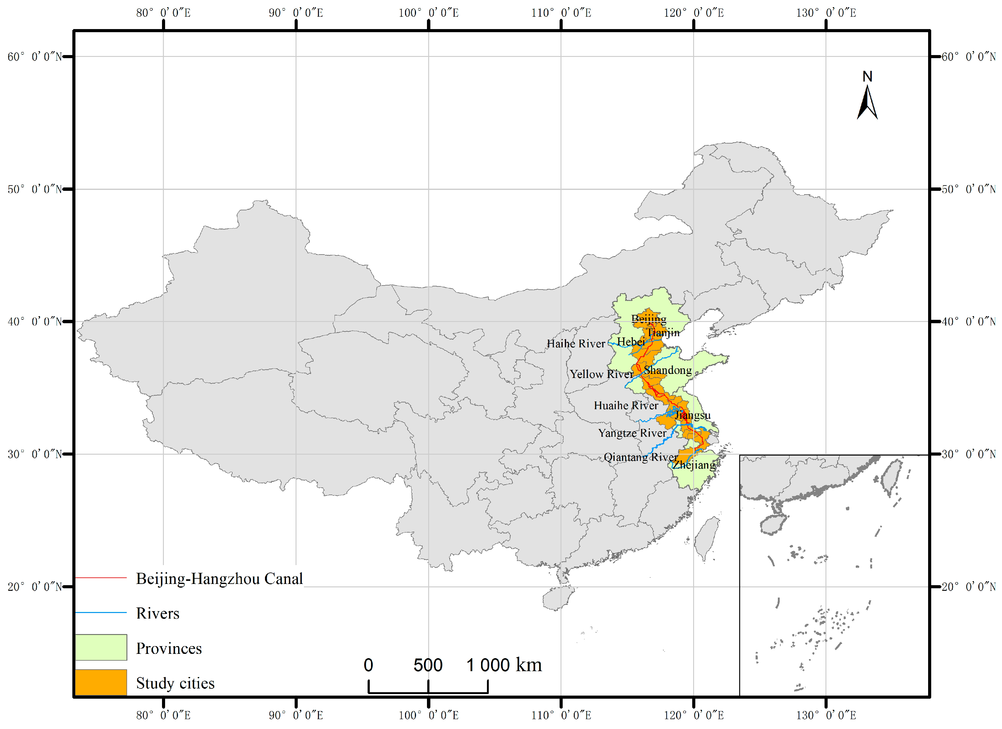
The Grand Canal in China is an important watershed that connects the northern and southern regions through five major river systems. The cities along the Canal are economically and socially developed, with high population density and a developed transportation network. Likewise, it is an important research area because the land use of rural residential areas on the Canal has changed significantly. The purpose of this study is to explore the driving factors that affect rural residential land. It analyses the spatial and temporal changes in rural residential land in 21 cities along the Grand Canal, as well as the natural environment and policies of these cities. The study used spatial remote sensing data from 1990 to 2020 to conduct the analysis. Furthermore, it used a point-axis-region three-dimensional (3D) spatial driving factor system to detect the driving factors of rural residential land in different cities. This paper selects the Grand Canal in China as a key case of economic development, deeply reveals the change in laws of rural residential land use, and analyzes the potential of rural residential land improvement in 21 cities based on the examination of the mechanism of the 3D spatial driving factor system, which offers insight into the necessary means for planning and intensively and economically utilizing rural residential land in the city.
3. Results
3.1. The Characteristics of Overall Changes in Land Use and Changes in Rural Residential Land
3.1.1. The Characteristics of Overall Changes in Land Use
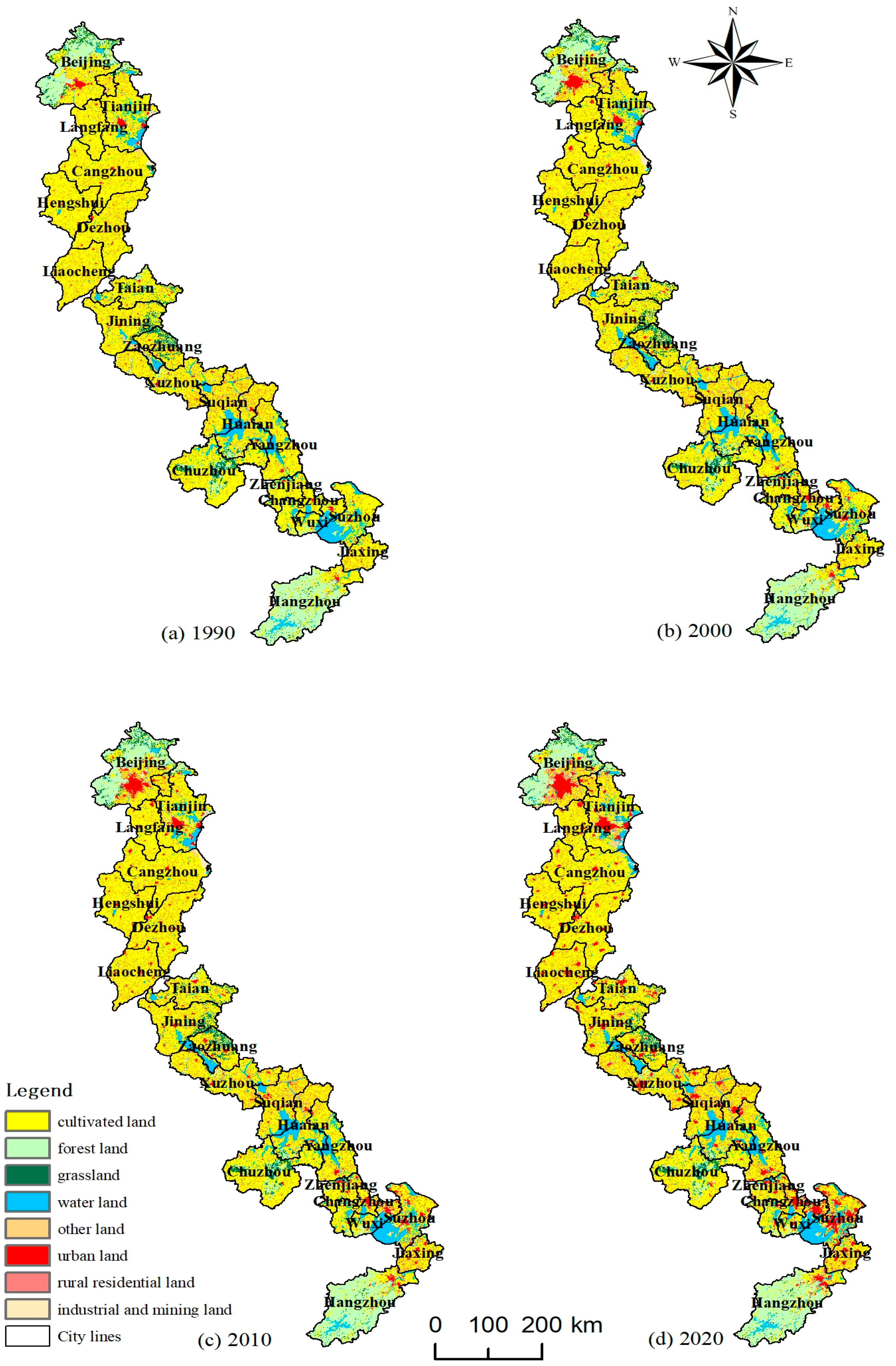
The land-use types of the Grand Canal mainly include agricultural land, forest land, rural residential land, water area land, grassland, and urban construction land. In 1990, the area proportions of the six land-use types were 64.6%, 12.6%, 8.8%, 8.0%, 3.1%, and 1.7%, respectively. In 2020, however, the area proportions of the six land-use types were 56.6%, 12.4%, 11.3%, 8.8%, 2.8%, and 6.5%, respectively. Agricultural land, urban construction land, and rural residential land were evenly distributed. In the north, the main expansion areas of urban construction land were Beijing and Tianjin, while in the south, they were Suzhou and Wuxi. The water area land was found in Tianjin, Huai’an, Yangzhou, and Suzhou, while forest land was found in Beijing, Jining, Zaozhuang, Chuzhou, and Hangzhou (
Figure 2).
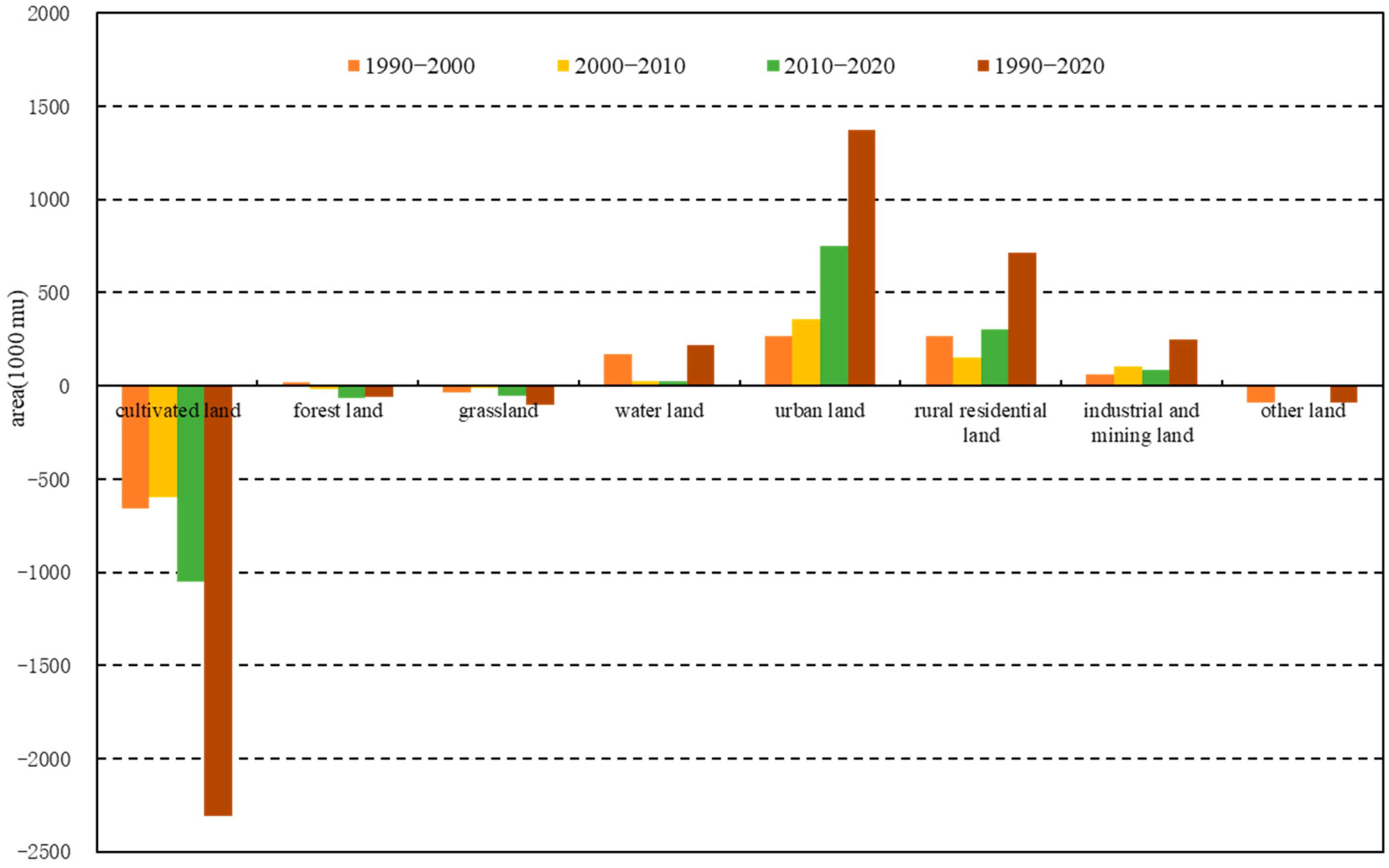
From 1990 to 2000, agricultural land, grassland, and other land decreased by 6.553 million mu, 353,000 mu, and 909,000 mu, respectively. Forest land, water area land, urban construction land, industrial and mining land, and rural residential land increased by 208,000 mu, 1.672 million mu, 2.663 million mu, 642,000 mu, and 2.649 million mu, respectively. At this stage, agricultural land and unused land were converted to water area land, urban construction land, and rural residential land. From 2000 to 2010, agricultural land, forest land, grassland, and other land decreased by 5.998 million mu, 170,000 mu, 110,000 mu, and 31,000 mu, respectively. In contrast, water area land, urban construction land, industrial and mining land, and rural residential land increased by 259,000 mu, 3.549 million mu, 1.009 million mu, and 1.492 million mu, respectively. This stage was characterized by the conversion of agricultural land to urban land and industrial and mining land. From 2010 to 2020, agricultural land, forest land, and grassland decreased by 10.502 million mu, 636,000 mu, and 544,000 mu, respectively, while water area land, urban construction land, industrial and mining land, and rural residential land increased by 232,000 mu, 7.51 million mu, 883,000 mu, and 3,011,000 mu, respectively. At this stage, agricultural land, forest land, and grassland were converted to urban industrial and mining land. From 1990 to 2020, the main areas that experienced significant changes were agricultural land, urban construction land, and rural residential land. In particular, agricultural land decreased by 23.053 million mu, accounting for 8.1% of the area. Urban construction land increased by 13.722 million mu, accounting for 4.8% of the area, while rural residential land increased by 5.6981 million mu, accounting for 2.5% of the area (
Figure 3). It can be seen that the reduced agricultural land, forest land, and grassland on the Grand Canal was converted to urban construction land, rural residential land, or industrial and mining land.
3.1.2. Characteristics of Changes in Rural Residential Land
From 1990 to 2020, the distribution of changes in rural residential land was relatively uniform, mainly concentrated in villages around the central urban areas of the cities on the Grand Canal. As time passed and new policies were introduced, there had been significant changes in the spatial layout of rural residential land, with some villages experiencing a decrease or an increase in area size. Within the 1 km × 1 km grid range, the proportion of changes in rural residential land in most cities ranged from −10% to 10%. Based on the spatial distribution of rural residential land, it was found that the extremely dense rural residential land in northern cities was mainly concentrated around Beijing, where rural residential land increased by over 50%. The areas with significantly sparse rural residential land were mainly distributed in Tianjin and Dezhou, where rural residential land decreased by over 50%. The significant increase in rural residential land in southern cities was mainly found in Suzhou, Wuxi, Changzhou, etc. The proportion of changes in rural residential land was between 20 and 50% (
Figure 4).
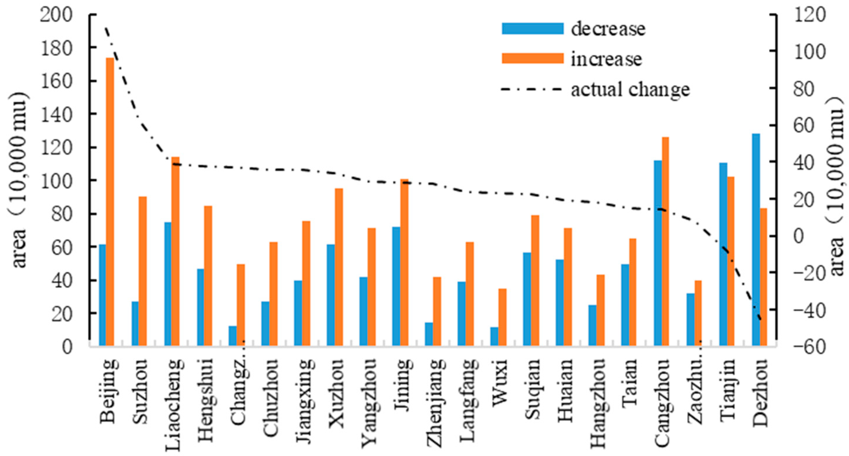
According to the changes in rural residential land area on the Grand Canal from 1990 to 2020, the total area increased by 16.6521 million mu and decreased by 10.954 million mu, resulting in an actual increase of 5.6981 million mu. Cities that have added over 1 million mu include Beijing, Cangzhou, Liaocheng, Tianjin, and Jining. Cities with an area of less than 500,000 mu include Changzhou, Hangzhou, Zhenjiang, Zaozhuang, and Wuxi. In contrast, cities with a decrease in rural residential land area of over 1 million mu include Dezhou, Cangzhou, and Tianjin, while cities with less than 300,000 mu include Chuzhou, Suzhou, Hangzhou, Zhenjiang, Changzhou, and Wuxi. Thus, it was found that the spatial changes in rural residential land in the northern cities of the Grand Canal were significant, while those in the southern cities were relatively small.
Based on the actual changes in rural residential land, it was found that only Beijing’s rural residential land increased by over 1 million mu, followed by Suzhou, with a rural residential land area of 629,000 mu. The size of rural residential land in Dezhou and Tianjin significantly decreased, with 449,500 mu and 85,100 mu, respectively. The change in the size of rural residential land in 12 cities ranges from 200,000 to 400,000 mu, while that in Huai’an, Tai’an, Hangzhou, Cangzhou, and Zaozhuang was less than 200,000 mu. Cities with per capita rural residential land exceeding 5 mu include Chuzhou, Yangzhou, Zhenjiang, and Hangzhou. However, cities with less than 2 mu include Liaocheng, Langfang, Zaozhuang, and Jiaxing (
Figure 5). Due to the impact of the rural population in different regions, the per capita rural residential land area in each region varied to some extent. For example, the per capita rural residential land area in the southern region of the Grand Canal was higher than that in the northern region. Thus, it can be inferred that Beijing and Suzhou, as the central cities of the northern and southern regions, respectively, had significantly higher levels of socio-economic development and urbanization compared to other regions. This had a strong effect on the changes in the size of rural residential land. However, as the main cities in Shandong Province began implementing the “Merging Villages and Towns” policy, Dezhou significantly reduced the size of rural residential land.
3.2. Driving Factors and Mechanism of the Change in Rural Residential Land
3.2.1. Driving Factors of Rural Residential Land
According to the distribution characteristics of the driving factors that influence the spatial differentiation of rural residential land, it was found that the distance to the market location, such as city centers, county centers, and town centers, was distributed in a clear concentric circle. The maximum distance to city or county centers was distributed in the peripheral areas of the Grand Canal, while the maximum distance to town centers was distributed around cities such as Cangzhou, Hengshui, and Suzhou. Furthermore, the spatial distribution of the distance to major motorways, railways, and rivers was zonal. The maximum distance to major railways was distributed in a line from Suqian, then to Huai’an, and finally to Yangzhou. The maximum distance to major motorways was found west of Liaocheng, while the maximum distance to rivers was located east of Tai’an. Lastly, the distribution of the factors of the natural environment, such as elevation and slope, were similar, with their maximum values distributed in the northern and southern peripheral areas of the study area (
Figure 6).
Using geographic detectors, this study found that all 21 cities were influenced by socio-economic driving factors. Except for Xuzhou City, 20 cities were affected by the driving factors of transportation accessibility. Only five cities, including Beijing, Tai’an, Zaozhuang, Zhenjiang, and Hangzhou, were affected by the driving factors of the natural environment. The distance to the city center had the greatest impact on the differentiation of rural residential land, with 20 cities being affected and an average decision-making power of 2.9. Next is the distance to the main rivers, which affected 19 cities with an average decision-making power of 1.9. The impact of elevation and slope was minimal. Elevation affected 4 cities, while slope affected 3 cities, with an average decision-making power of only 0.3 and 0.29, respectively (
Table 3).
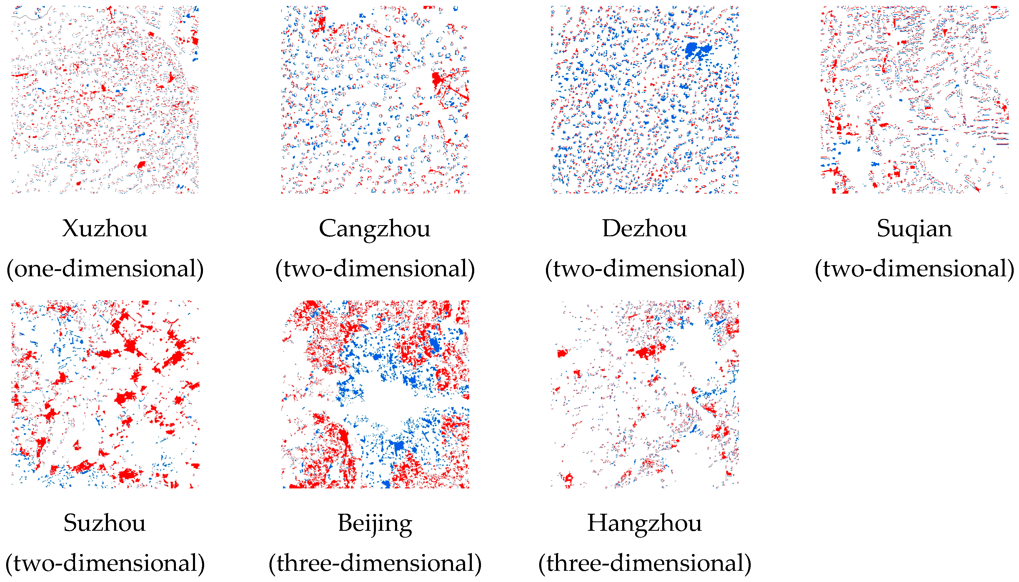
To further explore the differentiation types of rural residential land in 21 cities, the study divided all cities into three categories based on the dimensions of the driving factors. Xuzhou, the only one-dimensional city, was influenced by the distance to the city and the county center. Thus, it represents a point-driven development city. Next, two-dimensional cities, including 15 cities, among which are Tianjin, Langfang, and Cangzhou, were influenced by the distance to the city, county, or town center and the distance to the main railways, motorways, or rivers. These cities represent the main types of rural residential land, which can be termed point-axis-driven development cities. Finally, three-dimensional cities, including Beijing, Tai’an, Zaozhuang, Zhenjiang, and Hangzhou, were driven by a combination of socio-economic factors, transportation accessibility, and the natural environment. These cities represent the “point-axis-region-driven development cities”.
3.2.2. Driving Mechanism of the Change in Rural Residential Land
Based on the distribution characteristics of rural residential land in the cities and the influence of their point-axis-region 3D driving factors, this study further analyzed the driving factors of the change in rural residential land on the Grand Canal by combining the sources of increase and decrease in rural residential land in the cities. This has important implications for accelerating the high-quality development of the rural social economy and improving the land-use efficiency of rural residential land. Compared with previous research, this article attempts to construct a three-dimensional driving force model composed of market, environment, and transportation location factors [
42,
43]. By detecting the location factors of rural residential areas, the spatial differentiation mechanism of rural residential land in different cities is analyzed. The three-dimensional driving force model eliminates the inaccurate influence of the original administrative regional factors rasterization [
44]. Based on the location theory, it makes full use of the spatial driving factor distribution law to explore the driving mechanism of rural residential land, which can better understand the spatial distribution and change law of rural residential land and has important reference value for promoting the spatial planning and development of rural residential land.
- (1)
Socio-economic driving factors
The socio-economic driving factors include the distance to the city center, county center, or town center. Among the 21 cities on the Grand Canal, 8 cities were affected by these driving factors, while Suzhou, Yangzhou, and Tai’an were affected only by the distance to the city center. Due to rapid urbanization, urban centers, densely populated industrial areas, and central areas of regional socio-economic development have increased their demand for land and the size of urban land, leading to the occupation of surrounding rural residential land and agricultural land. Therefore, the rural residential land close to the urban area was reduced. To meet the demands of rural residents, a large amount of agricultural land was converted to rural residential land to establish new communities and build new residential areas in the suburbs. It was found that rural residential land around the urban center exhibited a block-like change, radiating to the surrounding area in a concentric circular shape. This result is most observable in the increase or decrease in rural residential areas in Beijing and Suzhou.
- (2)
Driving factors of transportation accessibility
The driving factors of transportation accessibility include the distance to main railways, motorways, and rivers. Among the 21 cities on the Grand Canal, 9 cities were affected by these factors. Langfang, Hengshui, and Jining were affected only by the distance to the main rivers. In these places, rapid industrialization and urbanization have led to the large-scale development of transportation arteries and primary roads, which have contributed to the socio-economic development of urban and rural areas. At the same time, the efficient and smooth operation of transportation arteries caused changes in land use along their routes, especially at crucial transportation hubs. To ensure the transportation of industrial and agricultural produce, most industrial parks were built along the main transportation arteries, occupying a large amount of agricultural and rural residential land. Thus, the rural residential land moved to the periphery of the transportation arteries and the surrounding areas. This study found that rural residential land surrounding the transportation arteries exhibited a linear change, i.e., it was distributed in a line toward the surrounding areas. Examples of these can be seen in the rural residential land in Suqian, where the increase or decrease of rural residential land was shown in a linear pattern.
- (3)
Driving factors of the natural environment
The driving factors of the natural environment include elevation and slope. Among the 21 cities on the Grand Canal, Beijing, and Hangzhou were affected by these factors. However, Tai’an and Zaozhuang were mainly affected by elevation, while Zhenjiang was affected by slope. The driving factors of the natural environment are relatively stable and have a significant impact on the spatial distribution and location of rural residential land, especially in the early stages of rural residential construction in which residential land was built on flat terrain and low elevation. As urban construction land expanded, rural residential land was continually being occupied, and some flat and low-lying areas in cities were converted to urban land. Nevertheless, rural residential land can only expand in three-dimensional spaces. The mountainous regions and ecological protection areas in the northern part of Beijing and the southern part of Hangzhou are unsuitable for the development of rural residential land due to high altitudes and rugged terrain. Thus, rural residential land in Beijing and Hangzhou established new high-quality communities to improve land-use efficiency in rural residential areas.
3.3. The Conversion Mechanism of Rural Residential Land
Through spatial correction and matching analysis, it was found that agricultural land was the main source of increase in rural residential land from 1990 to 2020, accounting for 93.09%, followed by forest land, accounting for 2.17%. The main sources of decrease in rural residential land were farmland, urban construction land, water area land, and industrial and mining land, with a proportion of 68.11%, 19.0%, 5.41%, and 5.03%, respectively. To further analyze the driving factors of the change in rural residential land in various cities, this study chose Beijing, Cangzhou, Dezhou, Chuzhou, Huai’an, Suzhou, Jiaxing, and Hangzhou cities as cases where the change in rural residential land was most prominent. It based the analysis on the driving factors and change in area size using an equal proportion amplification method.
3.3.1. The Conversion of Rural Residential Land in the One-Dimensional City
The only one-dimensional city in this study was Xuzhou. From 1990 to 2020, the area of rural residential land increased by 949,000 mu and decreased by 612,000 mu, thus actually increasing by 337,000 mu. The main sources of increase in rural residential land were agricultural land and forest land, with an area of 884,100 mu and 32,100 mu, respectively, accounting for 93.2% and 3.39%. However, the main source of decrease was also agricultural land, followed by urban construction land, with an area of 407,500 mu and 174,900 mu, respectively, accounting for 66.58% and 28.59%. This indicates that the source of changes in rural residential land in Xuzhou was agricultural land (
Figure 7). The change was mainly influenced by socio-economic driving factors, such as the distance to the city and county center, with a decision-making power of 0.73 and 0.60, respectively. Since Xuzhou is in the North China Plain and is flat, it was less affected by the driving factors of the natural environment. Moreover, Xuzhou is an important transportation hub that connects the Grand Canal to the eastern and western regions of China. Its main motorway and railway network density were relatively high, so it had little impact on the spatial differentiation of rural residential land.
3.3.2. The Conversion of Rural Residential Land in Two-Dimensional Cities
To examine the changes in rural residential land in two-dimensional cities, the study selected Cangzhou, Dezhou, Suqian, and Suzhou as representatives (
Figure 7). It found differences in the number of driving factors affecting each city. There were also differences in the changes in rural residential land. Due to the large number of two-dimensional cities, they were mainly influenced by the distance to the city, county, or town center and the distance to major railways, motorways, or rivers. In contrast, they were less affected by the driving factors of the natural environment.
The actual changes in rural residential land from 1990 to 2020 were 141,000 mu in Cangzhou, −449,500 mu in Dezhou, 222,400 mu in Suqian, and 629,000 mu in Suzhou (
Figure 7). Suzhou is the economic center of the southern part of the Grand Canal. In Suzhou, the actual increase in rural residential land area was second only to Beijing. The main sources of increase in rural residential land were agricultural land, water area land, and urban construction land, with an area proportion of 92.14%, 3.27%, and 2.66%, respectively. The main sources of decrease in rural residential land were urban construction land, agricultural land, and water area land, with an area proportion of 59.29%, 33.83%, and 4.07%, respectively. This city was mainly influenced by four driving factors, including the distance to the city center, the distance to main railways, the distance to main motorways, and the distance to main rivers, with a decision-making power of 3.93, 1.41, 0.73, and 2.09, respectively. Furthermore, Dezhou is one of the central cities of the Grand Canal. It experienced a negative growth in rural residential land from 1990 to 2020. The main sources of increase in rural residential land were agricultural land and other land, with an area proportion of 93.84% and 3.73%, respectively. However, the main source of decrease in rural residential land was also agricultural land, followed by urban construction land, with an area proportion of 89.0% and 8.97%, respectively. This city was influenced by five driving factors, including the distance to the city center, the distance to the town center, the distance to the main railways, the distance to the main motorways, and the distance to the main rivers. Each of these factors had a decision-making power of 4.16, 0.51, 1.34, 0.74, and 3.15, respectively. Next, Cangzhou is a city in the northern part of the Grand Canal. From 1990 to 2020, the increase and decrease in rural residential land exceeded 1 million mu. The main source of increase in rural residential land was agricultural land, accounting for 97.01% of the total area. The main sources of decrease in rural residential land were agricultural land, water area land, industrial and mining land, and urban construction land, with an area proportion of 65.06%, 18.31%, 12.46%, and 3.62%, respectively. This city was influenced by six driving factors, including the distance to the city center, the distance to the county center, the distance to the town center, the distance to the main railways, the distance to the main motorway, and the distance to the main rivers. These factors had a decision-making power of 19.12, 9.94, 0.77, 0.79, 0.65, and 4.40, respectively. Like Dezhou, Suqian is also one of the medial cities of the Grand Canal. It experienced a change in rural residential land area of less than 300,000 mu. The main source of increase in rural residential land was agricultural land, accounting for 96.98% of the total area. The main sources of decrease in rural residential land were agricultural land and urban construction land, with an area proportion of 72.43% and 25.34%, respectively. This city was mainly influenced by the distance to the county center, the distance to the main railways, and the distance to the main rivers, each of which had a decision-making power of 0.80, 1.87, and 1.12, respectively.
3.3.3. The Conversion of Rural Residential Land in Three-Dimensional Cities
To show the change in rural residential land in three-dimensional cities, this study selected Beijing and Hangzhou as representatives. From 1990 to 2020, the area of rural residential land increased by 1.736 million mu in Beijing and 430,000 mu in Hangzhou. It decreased by 616,000 mu and 248,000 mu, respectively. The actual increase in Beijing was 1.12 million mu and 182,000 mu in Hangzhou. The main sources of increase in rural residential land in Beijing were agricultural land, forest land, and grassland, with an area proportion of 85.46%, 7.57%, and 2.6%, respectively. The main sources of decrease in rural residential land were urban construction land, agricultural land, industrial and mining land, and forest land, with an area proportion of 51.83%, 23.59%, 13.35%, and 5.67%, respectively. The driving factors of rural residential land in Beijing were the distance to the city center, the distance to the town center, the distance to the main railways, the distance to main rivers, elevation, and slope. Their decision-making power was 2.03, 0.52, 0.51, 1.33, 0.97, and 0.90, respectively. In Hangzhou, the main sources of increase in rural residential land were agricultural land and forest land, with an area proportion of 86.76% and 10.39%, respectively. The main sources of decrease in rural residential land were agricultural land, urban construction land, industrial and mining land, and forest land, with an area proportion of 49.52%, 23.21%, 11.42%, and 11.27%, respectively. Similar to Beijing, the driving factors for rural residential land in Hangzhou include the distance to the city center, the distance to the county center, the distance to the town center, the distance to main railways, the distance to main rivers, elevation, and slope. Their decision-making power was 1.78, 1.32, 0.57, 1.46, 1.19, 1.32, and 1.62, respectively.
Beijing and Hangzhou are both economically developed cities in the northern and southern parts of the Grand Canal, respectively. As the capital of China, Beijing is a political, economic, and cultural center, with the largest area size in rural residential land and the greatest scale of converting rural residential land to urban construction land. Due to socio-economic development, the central urban area represents the main area where people live and work. Urban construction land continues to expand to the periphery, occupying a large amount of rural residential land and agricultural land. To meet the production and living demands of rural residents, a large amount of agricultural land has been transformed into new rural communities. The transportation network and various terrain types in Beijing have a significant impact on the selection of the space where rural residential land can be built, especially in the northern mountainous areas of Beijing, where the density of rural residential land is low and the proportion of its change is small.
As the capital of Zhejiang Province, Hangzhou is an important city in the Yangtze River Delta Economic Zone. The density of transportation arteries, such as railways and motorways, is high. Likewise, the speed at which urban construction land is expanding is high. Due to the influence of urban terrain and landforms, especially in the mountainous areas in the southern part of the city, the proportion of rural residential land converted to urban construction land is relatively low, and the proportion of the increase in rural residential land is relatively small.
3.4. The Potential for Rural Residential Land Improvement
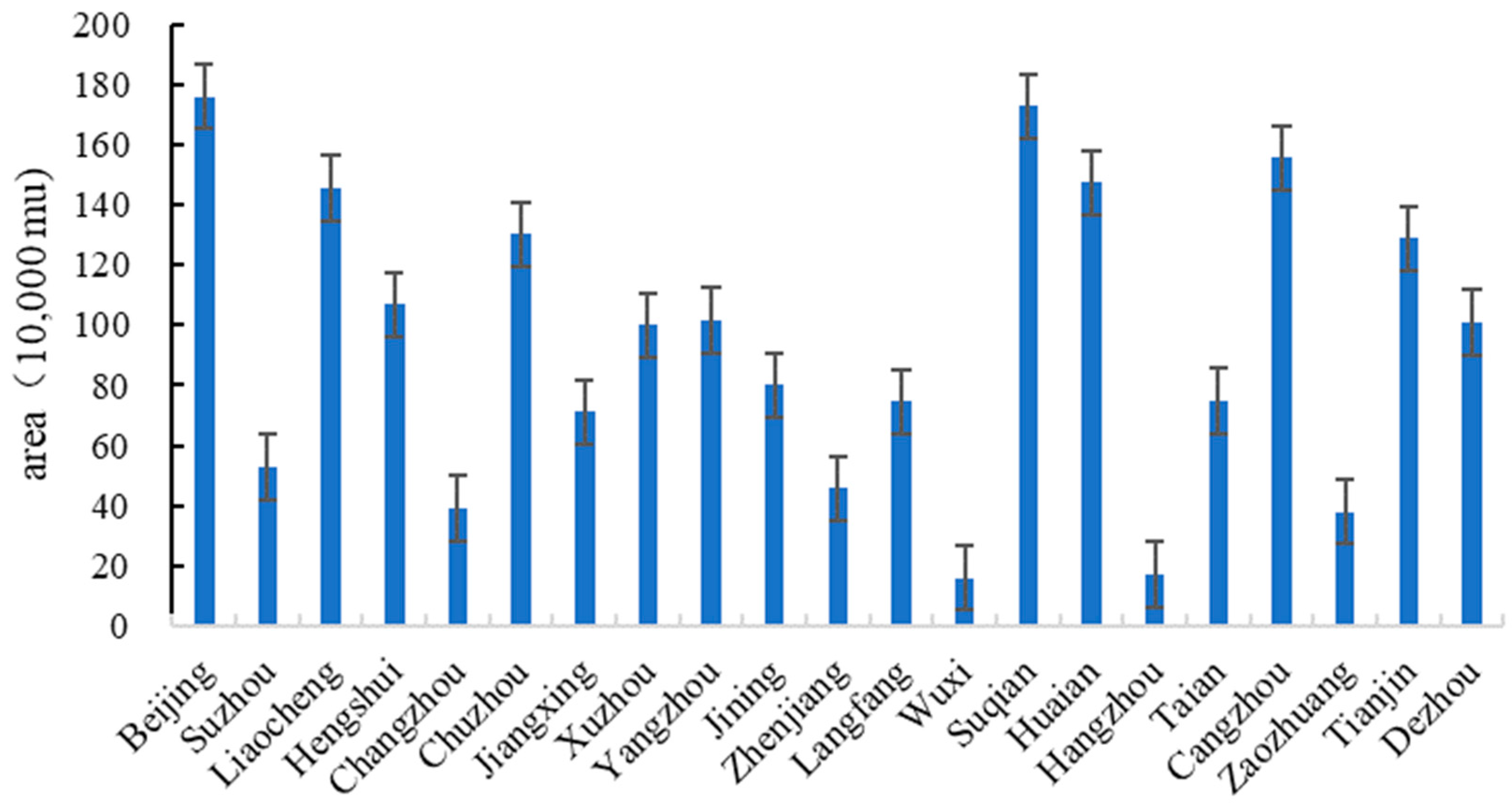
According to the calculation results, there are significant differences in the potential for rural residential land improvement among 21 cities. The total potential for rural residential land improvement in 21 cities is 19.7431 million mu. There are 10 cities with a remediation potential exceeding 1 million mu, among which Beijing has the largest remediation potential at 1.7593 million mu, followed by Suqian at 1.7267 million mu. There are 5 cities with a remediation potential of less than 0.5 million mu, with Wuxi having the lowest at 159,700 mu, followed by Hangzhou at 171,700 mu (
Figure 8). Meanwhile, from the perspective of overall spatial distribution, cities in the north have greater potential for land improvement in rural residential areas compared to cities in the south.
Why is there such a huge gap in the potential for rural residential improvement? The cities along the Grand Canal selected in this article are socioeconomically developed cities in the eastern region of China, with frequent rural population mobility and high urbanization rates. From 1990 to 2020, while urban boundaries continued to expand, the area of rural residential land also continued to increase. The rural residential areas in northern cities have flat terrain, and most farmers live in bungalows. Along with the construction of living courtyards, the area of rural residential land far exceeds national standards. The rural settlements in southern cities are mainly mountainous and hilly areas, with rural residential buildings as the main type, and the difference in land area between rural settlements and national standards is relatively small. At the same time, influenced by driving factors based on the spatiotemporal variation of rural residential land in various cities, cities such as Beijing, Cangzhou, and Liaocheng have a larger area of original rural residential land but a smaller rural population and are greatly affected by the market, transportation, and other driving factors, resulting in a greater weight of remediation potential and a higher potential for rural residential land improvement. However, cities such as Wuxi, Suzhou, and Hangzhou have a high level of urbanization, and a large amount of rural residential land has been occupied. The impact of driving factors is relatively small, resulting in a smaller weight of remediation potential and a lower potential for rural residential land improvement. Thus, compared to two-dimensional cities, three-dimensional cities have greater development potential for rural residential land. With the rapid socio-economic development of eastern coastal cities and the continuous migration of rural populations to cities, the problem of empty rural homesteads is becoming increasingly serious. How to fully utilize rural residential land and explore the transformation strategies of rural residential land use based on local conditions has important reference significance for the social and economic development of different regions.
5. Conclusions
Due to urbanization, the rural population has migrated to urban areas, resulting in a decrease in the efficiency of rural residential land use and an increase in the number of abandoned rural homesteads. In the context of integrating urban and rural areas and protecting farmlands, one key issue requires immediate attention. This issue deals with the scientific analysis of the remaining rural residential land to ensure the improvement of its land-use efficiency. This study analyzed the spatiotemporal differentiation of rural residential land in 21 cities on the Grand Canal under various driving factors using geographic detectors. It offered suggestions for scientific planning of rural residential land according to local conditions and provided a reference for the conservation and intensive use of that land. This study drew the following conclusions.
(1) The cities with a significant increase in rural residential land (over 1 million mu) in the Grand Canal were concentrated in the north, including Beijing, Tianjin, Cangzhou, etc. The cities with a smaller decrease (less than 300,000 mu) were mainly concentrated in the south, including Suzhou, Hangzhou, Zhenjiang, etc. It was found that the changes in rural residential land in the northern cities were significant. In contrast, the changes in rural residential land in the southern cities were relatively stable. The main sources of increase in the rural residential land include agricultural land and forest land, while the main sources of decrease include urban industrial and mining land and agricultural land. From 1990 to 2020, rural residential land experienced a cycle of changes in agricultural land, rural residential land, and urban construction land.
(2) The driving factors that affected the spatiotemporal differentiation of rural residential land were mainly manifested as socio-economic factors (points), transportation accessibility (axes), and the natural environment (regions). According to the number of driving factors and their decision-making power (greater than 0.5), the 21 cities were divided into three types: one-dimensional, two-dimensional, and three-dimensional cities. The one-dimensional city, Xuzhou, was mainly influenced by socio-economic factors. In this city, significant differences in the change in rural residential land could be spotted around urban centers. Moreover, the two-dimensional cities were mainly influenced by socio-economic factors and factors of transportation accessibility. This city type included 15 cities, such as Tianjin, Langfang, and Yangzhou. In these cities, rural residential land was found in circular and linear patterns around the urban center and main transportation arteries. Finally, the three-dimensional cities were influenced by all driving factors. This city type included five cities, such as Beijing, Hangzhou, and Tai’an. Apart from the rural residential land exhibiting a linear and circular pattern, the distribution of rural residential land in these cities was relatively scattered due to the rugged terrain.
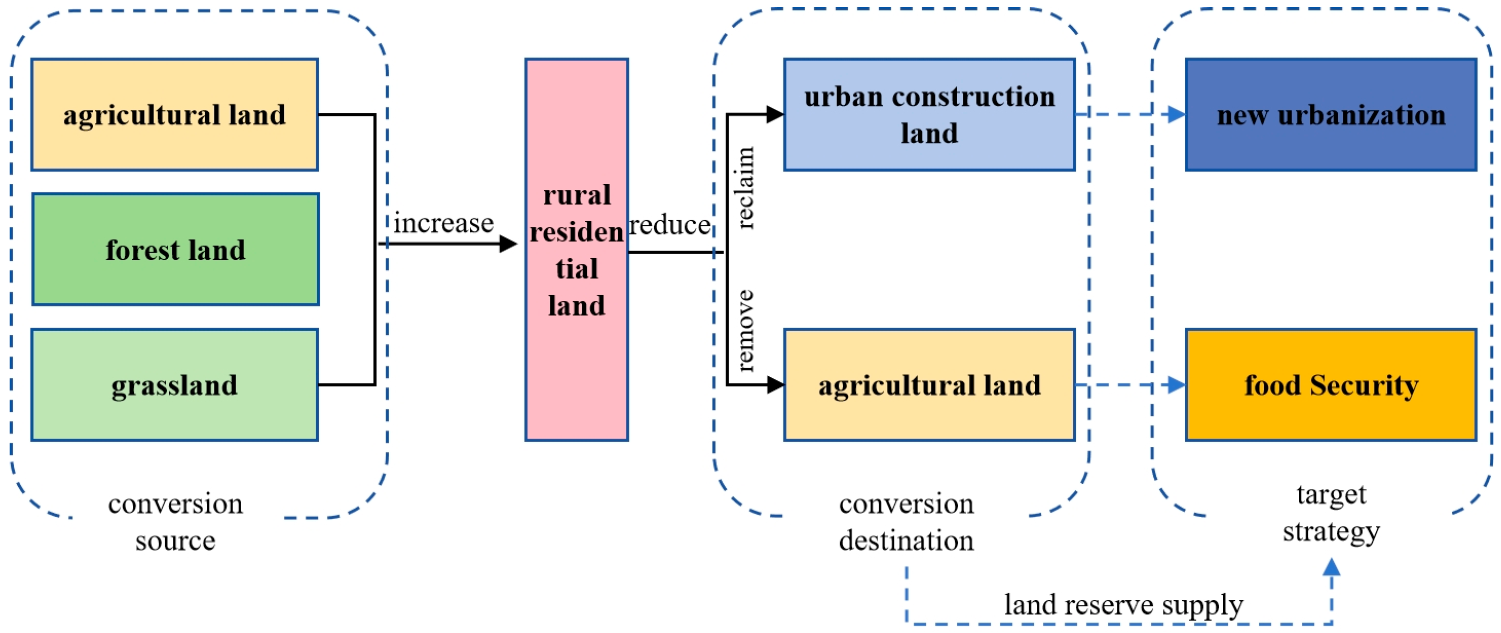
(3) Based on the spatial differentiation characteristics, driving factors of rural residential land, and the potential for land improvement in rural residential areas of different cities, this study proposed three types of villages to ensure the intensive use and careful planning of rural residential land and the protection of agricultural land and improve the efficiency of rural residential land use. These villages would be developed based on the following strategies: the construction of large-scale villages through relocation and consolidation, the construction of new villages through relocation and reconstruction, and the construction of advanced villages through intensive expansion and contraction. The relocation and consolidation of rural areas implies using old residential areas as the central village, merging multiple scattered villages in the surrounding area, and freeing up excess rural residential land and transforming it into agricultural land. Relocation and reconstruction-oriented rural areas imply building new villages in other suitable locations, relocating multiple existing villages, and constructing new larger villages. The original rural residential land would be converted to farmland, forests, or grasslands. These areas would then focus on ecological restoration. Intensive expansion and contraction of rural areas implies that they retain the original villages, improve the level of rural housing through renovation, move scattered rural homesteads to central villages through spatial replacement, transform the remaining rural homesteads into collective assets, and build commercial housing or shop houses to increase the collective economic income.
This study takes rural residential land in different cities as the research object, detects the spatial driving factors of spatial and temporal differences of rural residential land, and proposes a 3D spatial driving system to eliminate the impact of administrative factors rasterization through location grid data. The study focuses on the rural development laws of different cities in the Grand Canal area and on the potential estimation of rural residential land use. At the same time, this article attempts to construct a strip research method, selecting cities along the Grand Canal for comparison, which can better highlight the differences in the distribution of rural residential land along the linear terrain. However, due to the large scale of our research, we were not able to consider the actual development of specific villages, and there is a lack of comparison with similar studies in other regions. In the future, we will take specific villages as examples and conduct a detailed analysis of changes in rural residential land use and driving factors according to local conditions.


