Abstract
A multi-hazard analysis (seismic, landslide, flood) is conducted to verify the impact on the road network. The ENEA CIPCast platform is an innovative Decision Support System (DSS) that is used to implement the analyses using GIS. Using analytical and geoprocessing tools, the hazards were assessed and mapped. The overlapping of different geospatial layers allowed the implementation of a specific hazard map for the road network. Multi-hazard values were obtained using an appropriate matrix of single values, which were classified, and then summarized into four classes of values. The analyses were conducted at the regional (Campania region), provincial (Metropolitan City of Naples), and local scales (island of Ischia and municipality of Casamicciola Terme). In particular, the landslide event that struck Ischia island on 26 November 2022 and the municipality of Casamicciola Terme was considered as a case study to determine the impact on the road network, infrastructures, buildings, and jeopardizing inter-municipal connections. The results are mainly visualized through map processing and statistical summaries of the data. The management of the landslide debris, which can contain a multitude of fractions (waste, biomass and vegetation, sludge, soil, and rocks transported downstream by water), was also explored. This is a frontier issue for which international manuals and guidelines, as well as national and emergency acts, have been examined. A specific protocol for the sustainable management of the debris generated by floods and landslides is needed, and discussed in the present paper, to overcome emergencies after catastrophic events.
1. Introduction
The lifespan of infrastructure represents one of the most important challenges for the security and development of civilization [1,2,3]. Climate change and the increased frequency and intensity of disasters triggered by natural hazards put the security of the territories and people at risk [4,5]. Agenda 21 for sustainable development [6] first introduced the term, multi-hazard, stressing the need to complete research in this area to support planning, especially for those territories that are exposed to disasters triggered by natural hazards [7,8,9,10].
Many authors explain how one of the frontiers in research is to examine multi-risk scenarios, because there are well-defined methodological approaches available for individual risks [10,11,12,13]. In contrast, the combination of river floods [14], coastal floods [15], landslides [16,17,18,19], snow avalanches [20,21,22], and volcanic [23,24,25], seismic [25,26,27,28,29], and meteorological [30,31,32] hazards [33] is still difficult to determine.
Multi-risk has also been defined and considered as the implementation of methodologies and approaches aimed at estimating and mapping the possibility of one or more natural hazards occurring in a specific area [34], but there are approaches that compare different risks by adapting different methods of analysis to better achieve this goal [13,35]. Therefore, multi-hazard refers to an “all-hazard-at-a-place” concept [36,37,38,39] that can be classified using qualitative, semiquantitative, and quantitative perspectives.
GIS-based methodologies are particularly suitable for identifying the portions of land where disasters triggered by natural hazards of various kinds may occur [40,41,42]. The possibility of producing maps using the simple method of superimposing different natural hazards is one of the simplest, but at the same time, it is effective and usable for applications even for citizens or less experienced technicians. The distribution and intensity level of multi-hazard can also be obtained by assigning weights to each single hazard on the basis of specific social or economic parameters, such as the cost of damages, the number of people injured or killed, and the number of homeless people [43]. The Emergency Disaster Database [43,44], as well as the national and regional multi-risk approaches conducted in Germany [12] and Italy [45], are examples of mapping and relating different risk typologies for the territory. In France, the Délégation aux Risques Majeurs [46,47] is one of the most representative examples of multi-risk analyses carried out using the superposition of probability maps of seven different risks (Seismic hazard; Landslide hazard; Industrial accidents hazard; Forest fire hazard; Car accident hazard; Flood hazard; Hazard from dam collapse), and it is a useful tool at the different scales of investigation (regions, provinces, cities) [34].
Many areas are exposed to multiple natural and anthropogenic risks [48], but in Italy, a homogeneous and deterministic multi-risk analysis is not yet available [45]. In this context, the protection of Critical Infrastructures (CI) is a delicate task [49]. Critical infrastructures are defined as an “asset, system or part thereof […] which are essential for the maintenance of vital societal functions, health, safety, security, economic, or social well-being of people, and the disruption or destruction of which would have a significant impact in a […] State as a result of the failure to maintain those functions” [50]. Since 2005, the European Commission has adopted a green paper relating to a European program for the protection of critical infrastructures, which indicated the alternative policies to be followed concerning both the development of this program and the critical infrastructure warning information network [50].
Hazard monitoring, supported by Decision Support Systems (DSS), such as the ENEA’s Critical Infrastructure Protection risk analysis and the foreCast (CIPCast) platform [51], an inter-operable tool that can prove to be essential in the protection of critical CI, can provide effective support in dealing with issues related to hazard analysis and mapping [45,52,53,54]. GIS-based approaches are fundamental to carry out the hazard assessments, especially in realities that are so deeply marked by cyclically recurring disasters triggered by natural hazards (floods, landslides, earthquakes) [42,55,56,57,58]. The DSS are strategic for a continuous and careful monitoring of CI, given the intrinsic hydrogeological and seismic hazards of the national territory, allowing for real-time, cross-referenced information on the different hazards and, by systemizing the different information layers, using multi-hazard matrices for the investigation of the different types of CI [52,53,54,57,59,60]. This facilitates the prediction of the areas that are potentially exposed to greater hazards and the systemization of further data, which, combined with the vulnerability and the exposure of CI, for example, allow for the estimation of the specific risk and the overall risk [61,62,63,64,65]. For this reason, the CIPCast platform presents itself as a functional and cutting-edge tool in the field of real-time monitoring and detection for the purpose of targeted emergency management and the protection of the population, the built environment, and CI by incoming natural and man-made events.
CIPCast was conceived as a combination of free/open-source software environments and it is provided to customers through a user-friendly WebGIS interface, which allows:
- The access to a large information database for situational awareness;
- The forecast of the external event, with the support of multi-source datasets;
- The estimation of the location and the severity of damages induced on CI elements;
- The availability of critical services by accounting for cascading effects;
- The optimized reconfiguration strategies to CI operators.
The objectives of this work are:
- To validate the method implemented by Pollino et al. (2022) [45] for multi-hazard analysis;
- To update the ENEA’s CIPCast GeoDatabase;
- To implement a methodology related to the management of the debris generated by disasters triggered by natural hazards aiming to reduce the time and cost for an emergency response.
In this paper, we wanted to delve deeper into the topic of landslide debris management. In the case of disasters triggered by natural hazards, it is of fundamental importance to have and follow operational procedures that allow both to overcome the emergency and to optimize the recovery of materials and reduce waste production. The management of rubble in the case of earthquakes is an example [66,67,68].
As far as the management of debris, sludge and waste is concerned, it is evident that there is a lack of specific legislation at the international and European levels. Some guidelines of a non-binding nature are provided by international bodies [69,70,71,72,73,74,75,76]. The sanitization of animals’ bodies after catastrophes emerges in the international bibliography [77]. This is a frequent problem in the case of water and power supply disruptions [78,79]. The magnitude of the problem is directly correlated to the extent of the affected area and the time required to overcome the emergency.
Protocols and guidelines have been also produced by the European Union [72,80]. Even though there is no common protocol to manage the debris generated by catastrophic events, some attempt is in development in Italy [66,67,68]. For example, the National Civil Protection has already published operative protocols and their operational guidelines to manage the debris generated by earthquakes [81]. The Italian Ministry of Environment is producing a specific guideline on this topic because it is an emerging issue to resolve [82] (MASE 2023, in prep.). At present, the guidelines are mainly produced to solve the problem of rubble management generated by the collapse of buildings or CI [81]. In the case of the debris produced by landslides and floods, there is a higher heterogeneity of materials and more natural resources are involved, such as woods, soil, and water. The difficulties of separation, reuse of uncontaminated resources and reduction of waste are undeniably more complex. Debris management following disasters triggered by natural hazards has significant international implications and impacts [69,70,71,72,73,74,75,76], and there are some key points to consider: humanitarian, environmental, and economic impacts; infrastructure damage; cross-border implications; risk of secondary hazards (sanitary); and long-term recovery and resilience.
2. Study Area
The Campania region is located between the Tyrrhenian Sea in the Southwest and the southern Apennines in the Northeast (Figure 1).
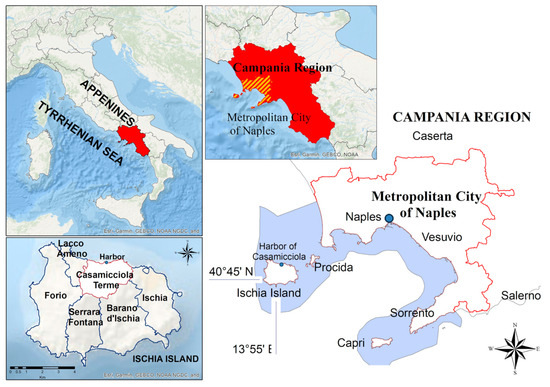
Figure 1.
Study area.
It has an area of 13,670.95 km2 and it is the most densely populated city in southern Italy, with 5,588,430 inhabitants (updated November 2023 [83]). The region has a very complex morphology, characterized by the Apennine mountains and hills inland [84]. The lowland areas are mainly distributed in the Caserta area and the province of Salerno (North of Naples); therefore, most of the region is exposed to humid Atlantic winds due to the proximity of the Apennine ridge to the coast. This results in heavy rainfall events along the coasts (average P 1000 mm/y) [85,86,87,88,89], which sometimes triggers landslides and flooding [84].
It is a region of medium-to-high seismic risk, and among the most significant events was the Irpinia earthquake of 23 November 1980 (MW 6.9), which caused about 280,000 evacuations, 8848 injuries, and 2914 deaths [90]. There are also six major volcanoes. The most famous are Vesuvius, Campi Flegrei, and the volcanic complex of the islands. Throughout history, the activities of these volcanoes have determined the morphological structure of the region and the entire country [84]. In particular, the eruptions of the Campi Flegrei are dangerous and still under monitoring and early warning surveillance by the Italian National Civil Protection system for bradyseism events [91].
Naples is the regional capital of Campania and has a metropolitan area of 1171 km2. The city has a population of about 2,967,310 (updated November 2023 [83]), with a very high population density of about 2535 inhabitants/km2 (updated February 2023 [83]). The island of Ischia is the most exposed to both seismic and landslide events due to unstable slopes [92], along which rainfall can easily wash away the surface debris downstream [84,93,94,95,96,97,98,99].
Ischia has more than four hundred hotels and several private holiday homes [100]. The landslide of 26 November 2022 was a calamitous event that affected, again, a highly anthropized and populated territory within the Ischia island, the municipality of Casamicciola Terme. The area affected by this event was of a considerable size compared with the overall size of the built-up area of the municipality (Casamicciola) and involved the mobilization of materials due to the debris flow. Romeo et al. (2023) [42] estimated a volume of ~40,000 m3 of debris and waste that occluded sewers and diverted waterways during this event, as had already happened in the previous debris flows (e.g., Ortolani, 2009 [55]). Following the flood events of 26 November 2022, in addition to some stretches of road, the infrastructure most affected was the Casamicciola harbor, which was invaded by mud and debris flowing down from the mountain towards the sea. Following the event, the port of Casamicciola became silted and the debris that accumulated inside reduced the depth, compromising the safety of navigation [42,101,102,103,104].
3. Data and Materials
Materials
In this section, the datasets used in the present study are listed and described. Firstly, a series of geospatial layers, stored in the CIPCast GeoDatabase, were integrated. These data were acquired from open/public sources or collected as part of previous projects [105]. The datasets can be classified, according to the specific typology, in a geographical and hazard table (see Table 1) and in a CI data table (see Table 2).

Table 1.
Geographical and hazardousness table of the 26 November 2022 Casamicciola landslide event dataset.

Table 2.
Road network CI dataset containing information on topology, length, corresponding management authority, and hierarchy (from a primary to a local level scale).
4. Methods
To produce the hazard maps at the different territorial scales, the ArcGIS Desktop (ArcMap v.10.8.) and QGIS Desktop (v. 3.28) suites were used. The following Steps were performed:
- Step 1. Data preparation and processing: to collect, organize, and process the basic data using the GIS software:
- ◦
- Implementation of single-hazard maps (flood, landslide, and earthquake);
- ◦
- Implementation of multi-hazard maps;
- ◦
- Implementation of landslide maps for the 26 November 2022 event (municipality of Casamicciola Terme), by intersecting and overlapping the considered CI;
- ◦
- Statistical analysis to calculate, for all the Areas of Interest (A.o.I.) (regional, provincial, island, and municipal scale), the length/number of the considered CI network (i.e., the road network) classified according to the different classes of hazard.
- Step 2. Data repository: to store data and metadata in a geospatial database (PostgreSQL/PostGIS) [114,115]:
- ◦
- All the GIS layers produced were uploaded and stored in the CIPCast GeoDatabase.
- Step 3. Analysis and elaboration: to manage stored data and metadata and publish them on the web (by means of the OGC standard) to enable geo-processing and risk analysis:
- ◦
- All the layers were organized in the GeoServer suite [116] for sharing and made available to the users via WMS.
- Step 4. Client front end (WebGIS application): multi-hazard analysis process.
- ◦
- Results of the analysis and mapping: all the elements and/or parts of CI classified at different hazard levels were published within the CIPCast WebGIS application.
The workflow used in the present study is reported in Figure 2.
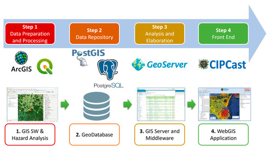
Figure 2.
Workflow implemented for the CIPCast platform. The multi-tier architecture of CIPCast is divided by Step (from 1. to 4.).
4.1. Hazardousness Mapping
Due to the importance and innovative contribution to the present study, the hazardousness mapping constitutes a core section (Section 4.1 and Section 4.2). The procedure used to achieve Step 1. has been schematized in Figure 3, in which the three main sub-steps that constitute the multi-hazard process are described. The latter updates the previous workflow proposed by Pollino et al. (2022) [45] (Figure 4 and Figure 5).
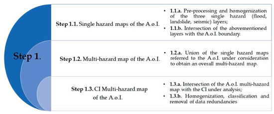
Figure 3.
Workflow of the multi-hazard analysis process (Step 1.) (Pollino et al. (2022) [45], modified).
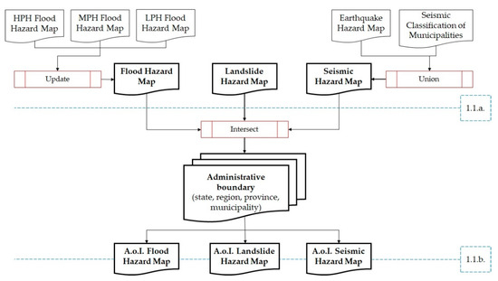
Figure 4.
Description of Step 1.1. of Figure 3: from a single-hazard map to a multi-hazard map of the Area of Interest (state, region, province, municipality) (Pollino et al. (2022) [45], modified).
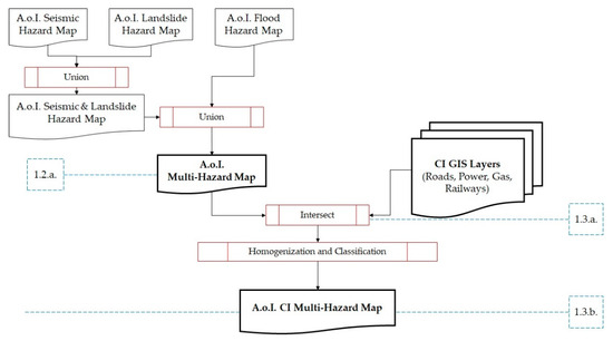
Figure 5.
Description of Step 1.2. and Step 1.3. of Figure 3: intersection of the CI under consideration with the multi-hazard map to create an overall CI multi-hazard map for the Area of Interest (state, region, province, municipality) (Pollino et al. (2022) [45], modified).
Step 1.1. consisted of selecting the national single-hazard maps (flood, landslide, and seismic separately) and the geospatial layers related to the CI under consideration. Pre-processing steps (1.1.a.) were conducted so that all layers were homogenized in the same cartographic reference system: RDN2008/UTM zone 33N (N-E) coordinates (EPSG:6708). The use of the ETRF2000 system in the 2008.0 is mandatory for the Italian Public Administration [117,118], as well as indicated in the European INSPIRE Directive (Technical Guidelines Annex I—D2.8.I.1; [119]).
Additional pre-processing steps were necessary for the hydraulic hazard maps from PAI 2020–2021 and the seismic hazard map. The flood hazard zones were mapped by the River Basin District Authorities (ISPRA National mosaic (v 5.0—2020) [106] and three different Probability Hazard Index (PH)x scenarios (Low, Medium, High) were defined according to the Legislative Decree 49/2010 [120] (implementation of the Flood Directive 2007/60/EC [121]). In the case of a hydraulic hazard, the PHx scenarios were merged into a synthetic GIS layer (using the Esri ArcGIS geoprocessing tool “Update”), in which the hazard classes were jointly mapped and hierarchically organized. In the seismic case, geoprocessing was used to join and homogenize the seismic hazard map in terms of PGA (“Peak Ground Acceleration” [107]), with the GIS layer containing the Seismic Classification of Italian Municipalities. This allowed us to provide an extended description of the seismic hazard for the entire Italian territory.
- For the three single-hazard classifications, we followed the coloring of the area subject to the specific hazard class proposed by:PAI 2020 for the flood hazard classes as defined by [106] and reported in the ISPRA Idrogeo Platform [56] (https://idrogeo.isprambiente.it/app/, accessed on 4 April 2024 [89]). In particular, the flood hazard classes (as previously described) were thematized using a descending scale of blue (and white color for the “Not at-risk zones” class);
- PAI 2020–2021 for the landslide hazard classes as defined by [106] and reported in the Idrogeo Platform [56] (https://idrogeo.isprambiente.it/app/, accessed on 4 April 2024 [89]). In particular, the National mosaic (v. 4.0—2020–2021) of the landslide hazard zones of the River Basin Plans (PAI) was mapped using the River Basin District Authorities. The landslide hazard was divided into six classes and thematized using a decreasing scale from red to yellow (and white color for the “Not at-risk zones” class);
- INGV seismic zonation [107] for the seismic hazard, with a four-color intensity scale, from red (max value, 0.35 g) to light green (min value, ≤0.05 g).
Another pre-processing activity was dedicated to the exclusion of specific areas (e.g., marine areas) from the study (1.1.a.). The maps of the national individual hazards, obtained as an intermediate result, were respectively merged into three new synthetic GIS layers, intersecting the three hazards separately with the Area of Interest (A.o.I.), i.e., the state, regional, provincial, island, or municipal boundaries; therefore, circumscribing the study to a more limited and defined area (1.1.b.).
Step 1.2. A multi-hazard map referring to the A.o.I. was obtained using the “Union” GIS tool, which was subsequently applied to all three layers mentioned above in step 1.1.b. (1.2.a.).
Step 1.3. The synthetic information layer was finally intersected with the CI under consideration (road network), obtaining the overall hazardousness information for each portion of the CI under analysis (1.3.a.).
The attribute titles were (if necessary) cleaned up/renamed and the redundancies resulting from the multiple geoprocessing steps were removed. The purpose of this procedure was to allow the comparison of the three different hazard scales and to classify the results according to a multi-hazard synthetic value. In addition, a specific attribute related to the code of each administrative region into which Italy was subdivided was inserted, to make it possible to perform the statistical analysis at all survey scales.
Following the abovementioned approach, the results were represented using a multi-hazard map of the analyzed CI system (1.3.b.) (Figure 5).
4.2. Multi-Hazard Index Values (MIV) and Multi-Hazard Index Classes (MIC)
In order to assign multi-hazard values (Multi-hazard Index Values—MIV) in a consistent manner, a specific matrix with four overall value classes was created, which allowed values ranging from 1 to 4 (where 1 is the minimum assignable and 4 the maximum assignable) to be assigned, depending on the relative hazard for each type of hazard investigated (Table 3).

Table 3.
Multi-hazard Index Values (MIV) assignable to the different hazard types (hydraulic, landslide, and seismic).
In detail, flood hazard was described using three classes of increasing probability (LPH, MPH, and HPH), with a value of 0 for areas not subject to flooding (“Not at Risk”). In the case of a landslide hazard, it was assumed that the attention zones (AA, for which, by definition, a precise zoning is not yet clearly defined) and the H1 zones (Moderate hazard) would be merged into a single class. Similarly, zones H3 and H4 (High and Very high hazard) were merged into the same class. The areas not subject to landslide phenomena were classified as 0. Detailed information on floods and landslides that have occurred in Italy over the years, as well as their territorial distribution, can be obtained from the ISPRA report on hydrogeological instability in Italy [106].
For seismic hazard, the four classes defined in the matrix fully reflected the national division into four zones. To homogenize the classes of the values of the multi-hazard matrix to the subdivision into four hazard zones at a national level, it was decided to summarize the MIV (with a minimum value obtainable from the sum of the three hazards equal to 3 and a maximum value obtainable from the sum of the three hazards equal to 12) using classes (Multi-hazard Index Classes—MIC). This process consisted of merging some of the multi-hazard values (3; 4, 5, 6; 7, 8, 9; 10, 11, 12) that were obtainable from the assignment of the corresponding MIV to the respective hazard (flood, landslide, and seismic) and reducing them to four classes (Low, Moderate, High, Very High) as described in Table 4.

Table 4.
Multi-hazard Index Values (MIV) sum and Classes (MIC) obtained from the homogenization and organization of the multi-hazard values into four classes.
For the multi-hazard mapping, an MIV scale in a red increasing intensity was chosen for the overall Ischia and Casamicciola road multi-hazard maps; a red-yellow-green scale, by increasing intensity, was chosen for the overlapping maps of the Casamicciola roads and the area of the 26 November 2022 event.
4.3. Mapping of the Casamicciola 26 November 2022 Debris-Flow Event
By means of the Copernicus EMS mapping [109], it was possible to elaborate and calculate the surface extension of the 26 November 2022 debris flow (km2 and m2) in Casamicciola Terme, using the ArcGIS Desktop suite. Purple oblique stripes were chosen for the 26 November 2022 landslide area thematization; blue oblique stripes were chosen for the area affected by the flood.
The obtained map was firstly merged with the contour map of the area and further compared with the hazard areas (hydraulic and landslide) attributable to the classification provided by the PAI 2021 [106], intersecting the Casamicciola territory.
The overlapping layers between both the debris flow, buildings, and road network of Casamicciola, and the flood and landslide hazard zoning (as indicated by the PAI 2021 [106]), with the building and debris flow were elaborated. A built-up basemap of Casamicciola, available using the OSM QGIS plug-in, was chosen as an overlapping field.
The length (km and m) and percentage of roads affected by the disaster of 26 November 2022 were then calculated and classified using multi-hazard MIV and MIC. Due to the absence of some MIV (in detail, MIV = 12 and 3), these were not included in the legend when carrying out the mapping, to make the representation clearer. A multi-hazard MIV scale using a red-yellow-green scale, by increasing intensity, was chosen.
4.4. CIPCast Implementation
The further in-depth phase of the work was devoted to implementing the geospatial layers obtained (Step 1.) on the ENEA CIPCast platform, as shown in the flowchart in Figure 1. The further steps of the CIPCast workflow consisted of: Step 2., in which all the GIS layers produced were stored in the CIPCast GeoDatabase (PostGIS/PostgreSQL [114,115]); Step 3., consisting of their configuration in the GeoServer [116] so as to be published; and Step 4., where the CIPCast WebGIS application was exploited to make the layers and maps available to the users via the WMS protocol (for further and in-depth process description see Pollino et al. (2022) [45]; and Giovinazzi et al. (2017), (2022) [53,54]).
In particular, the geospatial data were styled (color, thickness, and other visible attributes) to render them correctly in the WebGIS environment. The debris flow event layers were properly thematized for the CIPCast WebGIS interface, as described in Section 4 (Step 2., 3. and 4.).
Finally, the CI was characterized using a hierarchical scale, starting from the classification provided by the OpenStreetMap (“tags”) of the different hierarchical levels:
- Motorway;
- Trunk;
- Primary Road;
- Secondary Road;
- Local Road;
- Other Roads.
4.5. Debris Management
In Italy, after a calamitous event, a commissioner is usually appointed, who is a legal figure with special powers to authorize specific activities, while also applying the derogation of existing regulations in order to overcome emergencies. The methodology used in this article to better understand how to manage the debris generated by floods and landslides was developed in several stages:
- Bibliographic research at the international level;
- In situ surveys of the sites affected by the flood of 26 November 2022 (Ischia);
- Collection and analysis of administrative acts related to debris management activities (a summary of the relevant information contained in each authorization decree was considered in the present study even if it is not possible to submit a copy of the original documentation—in Italian);
- Implementation management scheme for debris management aimed at reducing costs and time by following the principles of the European directives on waste management and the circular economy.
5. Results
The results obtained are described to firstly provide an in-depth statistical calculation of the overall lengths and portions of the roads (km) and their percentage classified using single hazards, for each considered A.o.I (region, province, island, municipality). Furthermore, thanks to the MIV matrix, it was possible to assign an overall hazard value to each element/part of the CI considered, which can account for each specific individual hazard value in a synthetic and extensive manner. Therefore, the overall lengths and percentage of road for each different MIV and MIC were calculated. From the results obtained on the overall length of the road network for the different A.o.I., it was possible to calculate the road network extension for:
- The Campania region: ~61,435 km;
- The Metropolitan City of Naples: ~12,080 km;
- The island of Ischia: ~585 km;
- The Casamicciola Terme municipality: ~73 km.
- The data, listed above and suitably classified, are shown in Table 5.
 Table 5. Statistical breakdown of the overall length (km) and percentage (%) of the CI in the different considered A.o.I. (region, province, island, and municipality) by single hazards (flood, landslide, and seismic), multi-hazard values (MIV), and multi-hazard classes (MIC).
5.1. Multi-Hazard Mapping
Starting with the overall data collection in Table 5, the specific data related to the island of Ischia (and the municipality of Casamicciola Terme) were further processed to obtain a multi-hazard mapping for the whole road network. The roads of Ischia and their MIV are shown in Figure 6, thematized in a scale of red color, that clearly associates the increasing multi-hazard values (MIV) with the increasing color tones. The administrative boundary of the municipality of Casamicciola is highlighted with a blue line.
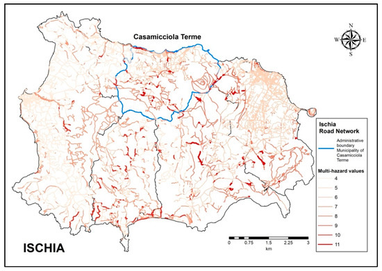
Figure 6.
Elaboration of the multi-hazard map of the road network CI of Ischia (40°45′ N–13°55′ E). The multi-hazard MIV scale is presented using a red scale, by increasing intensity (only values present in the area under examination).
5.2. Casamicciola 26 November 2022 Debris-Flow Event
In order to frame the area affected by the landslide that occurred on 26 November 2022 in a more in-depth manner, the map of the area of the event was superimposed on the contour-line graph, to highlight the strong slope that characterizes the northern slope of M. Epomeo, in the direction of the town of Casamicciola, as shown in Figure 7.
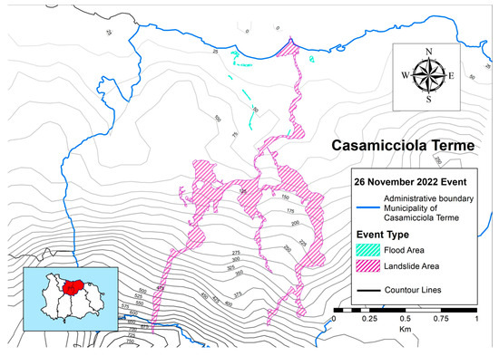
Figure 7.
Elaboration of the areal extension of the 26 November 2022 event of Casamicciola Terme with contour lines (40°45′ N–13°55′ E).
GIS analytical processing conducted on the event data (i.e., geometric calculations on the attribute table of the GIS layers) showed that the area struck by the landslide was approximately 0.282 km2 (~282,000 m2), and the area affected by flooding (flash flood) was 0.004 km2 (~4000 m2). The areal map of the event was then merged into both the ArcGIS Desktop and QGIS suites. ArcGIS was firstly used to provide the spatial overlapping of the event and the PAI 2021 flooding map (see Figure 8).
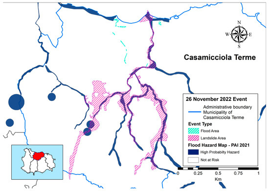
Figure 8.
Elaboration of the 26 November 2022 debris-flow event of Casamicciola Terme: overlapping PAI 2021 flooding map (only hazard classes present in the area under examination) and the event-struck area (40°45′ N–13°55′ E).
The second step was performed using the QGIS suite. Starting with the data shown in Figure 8, this allowed us to provide an in-depth analysis that highlighted the landslide path, the PAI 2021 flooding map, and the overlapping area of the latter with the built-up area of Casamicciola (see Figure 9).
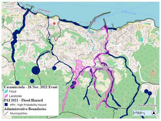
Figure 9.
QGIS visualization of the Casamicciola 26 November 2022 debris-flow event: overlapping layers of the struck area, the Ischia and Casamicciola boundaries, and the PAI 2021 flooding map (OSM basemap) with the Casamicciola built-up area (40°45′ N–13°55′ E).
The multi-hazard layer of the Casamicciola Terme road network (see Figure 10) was then merged with the 26 November 2022 debris-flow extension layer. The color scale was differentiated from the others, opting for a multi-hazard MIV scale using a red-yellow-green scale, by increasing intensity, for a clearer readability of the map. From this layer, it was possible to extract the information on the different MIV of each road portion affected by the event and the percentage values. The length of the road network struck by the landslide event was ~5.1 km; the area that was affected by flooding was ~0.7 km of the overall extension of the municipal roads.
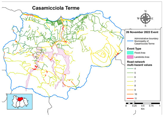
Figure 10.
Elaboration of the debris flow struck area overlapping the multi-hazard map of the overall Casamicciola road network CI. The multi-hazard MIV scale is presented using a red-yellow-green scale, by increasing intensity (only values present in the area under examination).
Furthermore, we processed the overall multi-hazard map of the Casamicciola road network struck by the debris flow. Thus, every struck portion of the CI under consideration was extracted; finally, for the latter, the corresponding total and percentage km classified using MIV were calculated (see Figure 11). The analysis showed that ~1.7 km (2%) of the struck Casamicciola road network corresponded to an “MIV = 5”; ~2.8 km (4%) was exposed to a multi-hazardousness corresponding to an “MIV = 8”; and ~0.3 km (1%) corresponded to an “MIV = 11”.
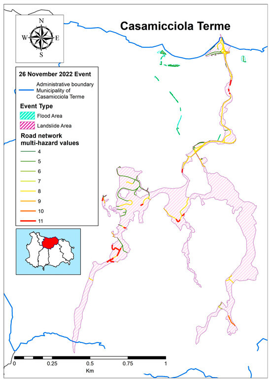
Figure 11.
Elaboration the portion of the roads within the area struck by the event of Casamicciola Terme (40°45′ N–13°55′ E). The multi-hazard MIV scale is here presented using a red-yellow-green scale, by increasing intensity.
5.3. CIPCast Implementation
The mapping of the 26 November 2022 event that affected the island of Ischia (and more specifically Casamicciola Terme) and its impact on the Casamicciola road network, were implemented using the ENEA CIPCast platform. The layers described in Section 5.1 and Section 5.2 were first processed and appropriately themed, loaded into the CIPCast GeoDatabase (PostGIS/PostgreSQL), and then configured into GeoServer to be published within the CIPCast WebGIS interface. By exploiting the platform, it was possible to select and query—among the different information layers available—the layers processed and produced in the present study (Figure 12). Moreover, the event area can be overlaid with the road network, categorized in detail by hierarchical level according to the categorization derived using the OSM classification (“tags”).
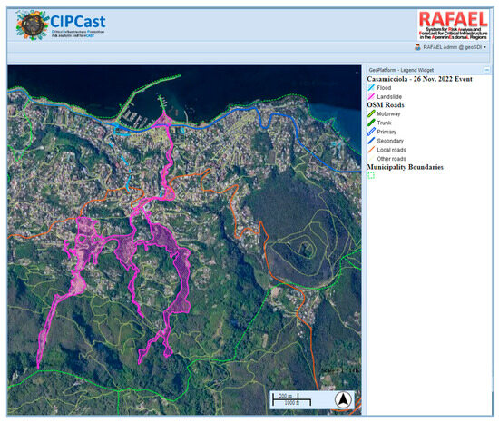
Figure 12.
Visualization of the 26 November 2022 landslide and the Casamicciola road network thematized by hierarchical level using the WebGIS interface of the CIPCast platform (ENEA): e.g., the Casamicciola boundary; the 26 November 2022 event area; the built-up area; and the road network and its multi-hazard values. The struck area is overlapped on the Google Satellite basemap. Legend size has been emphasized (the study area is located at 40°45′ N–13°55′ E).
5.4. Debris Management
In general, it is not possible to know the composition of the debris generated by disasters triggered by natural hazards. Therefore, their management is not straightforward and international guidelines show several differences in application and operative protocols. Rather than using a general methodological approach, manuals describe the activities carried out or general operational protocols to be followed during emergencies, but they are not always related to the debris [69,70,71,72,73,74,75,76].
The 26 November 2022 disaster event that happened in Ischia has peculiarities that distinguish it from many others:
- An island;
- Difficult connections to the mainland;
- A steep territory near the coast;
- Many houses, buildings, and critical infrastructure (roads and ports) exposed to slope vulnerability.
These characteristics caused the siltation within the Casamicciola harbor by landslide fine materials. As a result, the debris was transferred to collection sites or disposed of on the mainland and part of this (the total amount is unknown) was recovered on the island (for naturalistic engineering with vegetation and lithoids).
The Port of Casamicciola, however, was dredged to restore and improve its functionality. The characterizations of sediments, dredging operations, and offshore dumping were completed in less than 8 months. The dredging operations were carried out by means of an environmental bucket (hermetic bucket), mounted on a self-loading motorized skip, which was equipped with an openable bottom [104]. The dredged sediments were transported and submerged at 7.5 km offshore (at a depth of more than 100 m; see Figure 13). The quality of the dredged material was determined using accurate characterization and the dredged volume was calculated in order to restore the depth of the seabed within the marina as per the original design (i.e., as it was before the flood event; see methodology of Cappucci et al. (2020) [67]).
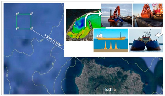
Figure 13.
Sediment management of the Casamicciola Harbor. The green box represents the dumping area of the dredged sediment (From: Sutera, 2023 [104]).
6. Discussion
6.1. Critical Infrastructures
CI plays a fundamental role in a country’s economy and development. Among the strategic CI, the road network is certainly in the sphere of essential services provided to citizens and provides a strategic rule in mobility and transport [45,50,122]. The research conducted in the present study revealed that data processing and analyses provide information that is relevant to understand the hazard at different spatial scales. CIPCast is an innovative Spatial Decision Support System (S-DSS) and interoperable platform for CI hazard mapping and risk analysis [45,52,53,54]. It is based on a multi-tier architecture composed of four steps.
In the present study, each specific individual hazard value (flood, seismic, landslide) was combined in a synthetic and extensive manner to analyze the results of the present study according to scale. The multi-hazard Index Values (MIV) matrix made it possible to assign a value to each element/part of the CI considered.
At the regional level, the Campania Region presented both hydrogeological and seismic criticalities. Of its ~61,435 km of road network, ~57,000 km (about 94%) is not subject to hydraulic hazard, while ~4000 km (about 6%) is exposed to medium and high hydraulic hazards (MPH and HPH). Almost 50% of the roads are subject to a landslide hazard with ~12,000 km of roads falling in the landslide hazard classes of medium to very high. About 14% of the road network in Campania is subject to high and very high hazards. As far as seismic hazard is concerned, all roads are exposed to a high seismic hazard, and are entirely between the medium and very high hazard levels. In particular, ~8300 km of the regional roads (14%) are in the latter hazard class.
Multi-hazard classes were estimated for the road network CI in the Campania region, which fell within the multi-hazard classes from “Moderate” to “Very High”. In detail, 75% of the roads fell in the “Moderate” hazard class (~46,250 km); 24% fell in the “High” hazard class (~14,800 km); and 1% of roads fell in the “Very High” hazard class (~400 km).
At the provincial level, the Metropolitan City of Naples presented several and relevant data on hazards concerning the multi-hazard affecting the territory and the road network (extended for about 12,080 km). Ninety-four percent of Neapolitan roads (~11,730 km) are not subject to hydraulic hazard. Six percent of the road network (~700 km) is exposed to hydraulic hazard and, of the latter, 3% of roads (~400 km) are subject to the highest flood hazard (HPH).
Landslide hazard impacts 20% of roads, which correspond to more than ~1600 km of CI subject to medium to very high landslide hazards (13.5%). The roads of the Metropolitan City of Naples are subject to medium to high seismic hazards, with 28% of the road network (~3350 km) in the medium seismic hazard class and as much as 72% of the roads in the high hazard class (~8700 km).
The Metropolitan City of Naples is highly urbanized; however, the extent of the impact on local traffic and the duration of their closure due to a natural event depends on many factors. In general, areas most prone to landslide hazards are concentrated in the hills and mountains of the province, along the steepest slopes of the islands and in the Sorrento Peninsula area (south of Naples). In these areas, the roads are few and of secondary importance, primarily connecting rural areas.
Some other areas subject to a high landslide hazard are also located along small sections of the internal highways, the Naples ring road (near the civil airport of Capodichino) and the Campi Flegrei (Naples ring road A56 between the municipality of Quarto, the municipality of Pozzuoli, and the western outskirts of Naples), which connects the capital with neighboring municipalities.
Multi-hazard Index Classes (MIC) showed that 85% of the Neapolitan province road network (~10,300 km) has a “Moderate” multi-hazard class. The remaining 15% was divided between the classes “High” (~1700 km; 14%) and “Very High” (~80 km; the remaining 1%).
On the island of Ischia, 7% (~40 km) of the overall road network CI (about 585 km) was affected by the highest hydraulic hazard class (HPH). Approximately 36% (~210 km) of the roads were subjected to a landslide hazard, and 28% of these (~162 km) were exposed to the high (~81 km; 14%) and very high (~81 km; 14%) hazard classes.
In addition, the entire road network of Ischia was exposed to a seismic hazard with the medium (~51%) and high (49%) hazard classes. Therefore, 100% of the road network on the island of Ischia was subject to a significant multi-hazard, with 67% of its roads falling into the “Moderate” class, 31% into the “High” class, and the remaining 2% into the “Very High” class. The road system is of fundamental importance on a small island for a multitude of reasons [123] because tourism, economic development, security, and safety are all guaranteed by the road network as a primary and lifeline infrastructure [67,124]. It allows transit to and from the island’s hospital and, during emergencies, roads are the only way to connect and assist the population without helicopters.
Within the municipality of Casamicciola Terme, ~73 km of the roads were present and 7% (~8.3 km) were affected by the highest hydraulic hazard class (HPH). Approximately 42% (~50 km) of the roads were in territories with a landslide hazard from moderate to very high, 15% (~17 km) of the roads were in the high class and 20% (~25 km) were in the very high class. Obviously, a seismic hazard is present on 100% of the road network, but the medium hazard class impact was 19% (~25 km) and the high hazard class was 81% (~60 km).
Multi-hazard analysis revealed that 56% of the roads were in the “Moderate” class, 42% were in the “High” class, and the remaining 3% were in the “Very High” class. To summarize, almost one tenth of the IC road network in the municipality of Casamicciola Terme was subject to a hydraulic hazard and almost half was subject to a landslide hazard, while it was totally exposed to a seismic hazard with a mainly high hazard class. The whole municipal road network was subject to multi-hazard, an important fact in terms of protecting the population and managing emergencies related to disasters triggered by natural hazards. The possibility of timely and effective intervention in the case of disasters triggered by natural hazards characterizes the island and recurs over time; therefore, this is a central theme for the management of emergencies on the island and in the municipality of Casamicciola Terme in particular.
What emerges from this analysis is that the roads in a territory are like the circulatory system in the human body. When they are functioning, no one thinks about their importance, but when a catastrophic event compromises their use, suddenly the system does not work, and the importance of the roads’ critical infrastructure emerges. Roads can be still considered the engine of the economy and their importance is inverse compared with extension of the study area. In the case of the island of Ischia, travel to and from the tourist resorts, access to beaches and sites of natural and archaeological interest, and the supply of necessities that serve to support tourism are irreplaceable.
The landslide generated by the heavy rain affected the seaside escarpment along the highway SS No. 270, which is the connecting road between the municipality of Casamicciola Terme and the neighboring municipalities of Lacco Ameno, Forio, and Ischia. In addition, SS270 is fundamental because it is the main route to reach the only hospital on the island, located in the municipality of Lacco Ameno, in a reasonable time. This fact underscores the importance, especially in realities in which the viability between municipalities and within the municipality itself are limited and essential. Careful management of the territory and the CI becomes a serious problem that needs to be overcome quickly by the decision-maker and the competent authorities from both operative and legislative aspects. Therefore, it is essential to monitor and manage the road network and the dangers to which they are constantly exposed. This issue is even more important in small and isolated territories and communities in case of rescue requirements.
Some stretches of road became flood torrent beds themselves, carrying from upstream to the sea everything that they found along the way, which damaged not only the critical infrastructures but also demolished some homes due to the excessive load and the flow velocity. Besides some limitations of the qualitative approach used in this study for the multi-risk analysis, the findings of the present research have the potential to aid the decision-makers in charge of the CI in the regions considered in the case study, so that the impact of disasters triggered by natural hazards can be mitigated.
6.2. Debris Management
Once again, the management of the debris generated by various disasters triggered by natural hazards appears to be fundamental to overcome emergencies. Figure 14 shows the severity of the flood event that occurred on 26 November 2022 and the extent of the disruption from the mountains inland to the sea, with vegetation, lithoids, vehicles, miscellaneous waste in some spots, and piles of rubbish (see Figure 14a–f).
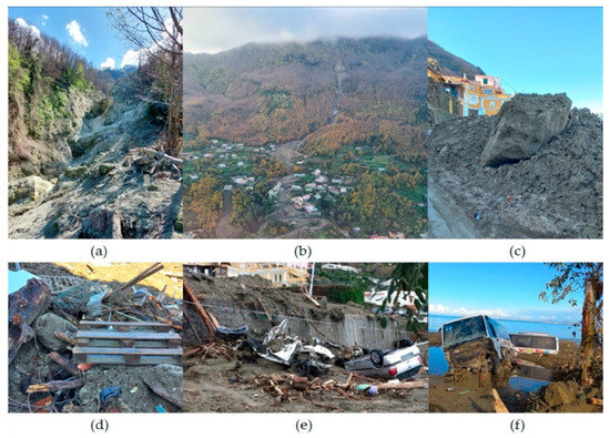
Figure 14.
The debris of the mudflow into the riverbed (a,b), along the road network (c–e) down to the Port of Casamicciola (f), after the 26 November 2022 event. Photo of Prof. V. Baiocchi; M.G. Farrace; ANSA (15.e; [125]).
The foot of the landslide reached the sea, silting up the port of Casamicciola, which reduced its depth, and it remained full of mud, sand, and debris for several months. The finest fraction of the material transported downstream by the landslide forced the competent local authority to conduct a dredging to guarantee the safety of navigation and connection to the mainland by ferries.
In addition, during the management operation, the liquid fraction was also subjected to strict regulation to avoid contamination during all steps of transport, treatment, and consequent management [126]. In May 2023, the Emilia Romagna region (Northern Italy) was flooded and many landslides occurred. The management of the debris was approached through promoting reuse and recovery in order to mitigate the impacts and reestablish safety levels and normal living conditions in a shorter time [127]. Based on recent emergencies that have occurred in Italy, the RETURN Project is implementing a methodology to manage the debris generated by disasters triggered by natural hazards (i.e., floods and landslides in particular). At present, lithoids, vegetation, WEEE (“Waste from Electrical and Electronic Equipment” [128]), and sediment management are adopted following the criteria of the circular economy and the sustainable use of natural resources; a general workflow is reported in Figure 15.
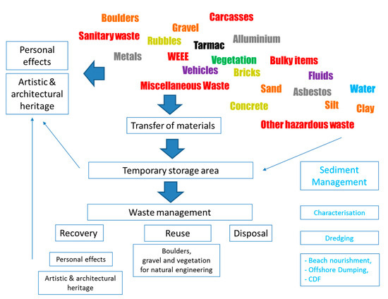
Figure 15.
Graphical representation of the debris composition and management (Grey: metals and minerals; Black: tarmac; Brown: lithoids; Green: Vegetation; Purples: vehicle and liquid wastes; Red: hazardous wastes). Among the artistic and architectural heritage, the personal effects are sometimes included.
The management of the debris generated by disasters triggered by natural hazards is a very complex topic. A standard protocol is not easy to produce, but it certainly involves a lot of technical and economic effort to ensure that the material recovered from the landslide debris or from dredging is compatible with the restrictions of the international and European legislation. Figure 15 is self-explanatory and must be considered a preliminary general workflow adopted for debris management that can be implemented in the future.
Disaster events are generated through different processes that cause different risks and impacts on CI. In the future, different guidelines and protocols should be adopted, depending on the damaged CI and the fractions of material/waste generated that could be recovered to avoid disposal. In Italy, there are no guidelines on the management of sludge produced by flood and ground instabilities. The planning of debris management cannot be standardized; therefore, debris is often considered as dangerous or mixed waste and is disposed and/or managed considering the facilities and characteristics of territory.
The island of Ischia has few waste management facilities and the transfer of waste by sea to services on the mainland has been necessary. The deputy manager, appointed using extraordinary legislation, finalized the debris and sludge management activities so that the terrestrial and marine environment would be protected to apply the principles of reuse, recycling, prevention, preparation for reuse, recovery, and minimizing landfilling.
Following the principles of the circular economy, the recovered lithoids have been primarily reused for restoration, extension, or the new construction of dry-stone walls, with the function of protection from landslides and alluvial phenomena. In this way, future hydraulic and hydrogeological risks are mitigated. The municipality of Casamicciola has allowed the use of stones collected from debris for ornamental use along walls, pathways, and public gardens. Vegetal materials have been used for natural engineering and NBS, such as protection and containment from meteorological events through fences and barriers. Biomasses were distributed and given to the population and to combustion for energy production and burning activities of plant residues were allowed; therefore, the disposal of lithoids and wooden materials was simplified by several administrative Acts [129,130,131,132,133].
In Ischia, the debris silted within the harbor were removed by applying the options available for sediment management [124]. Beach nourishment was also considered to protect and nourish the sandy coast by reusing/recycling a compatible fraction of debris, but the dredged material, after characterization, was dumped offshore [67,120,134,135].
In general, the objective of decreasing the production of waste and favoring the reuse and recycling of debris should always be considered, according to the principles of “protection and enhancement of the environment […]” and “transparency and cost-effectiveness” [121].
7. Conclusions
CI in the Campania region are affected by several hazards. The multi-hazard classification proposed in this paper suggests that continuous and careful monitoring is required as the exposure to catastrophic events is significant. The Metropolitan City of Naples has a portion of the road network CI subject to significant multi-hazards. The nearby area of Campi Flegrei is under monitoring at present and an emergency plan is ready to be adopted in the case of increased seismic activity. In general, monitoring actions appear necessary to ensure functionality and safety in the event of disasters, especially in some areas.
One of the most critical locations is the island of Ischia, which is periodically affected by disasters triggered by natural hazards. In this paper, we discovered that almost one tenth of Ischia’s road network is prone to hydraulic hazard and more than one third is subject to landslide hazard, while it is totally exposed to seismic hazard with important hazard classes (medium and high). Ischia was recently affected by an earthquake in 2017 (2 people were killed and 42 people were injured) and a catastrophic flood in 2022 that caused 12 deaths, 5 injuries, 462 people were displaced, and 40 homes were affected.
The management of debris generated by disasters triggered by natural hazards is a very complex topic and literature review, and at an international level, it is not sufficient to face administrative, technical, scientific, and practical issues. In the past few months in Italy, steps forward have been taken to improve the sustainable use of debris, but only a small part of these can avoid landfilling. The management of debris generated by various disasters triggered by natural hazards (floods, landslides, earthquakes) appears to be fundamental and a pioneering topic strongly related to critical infrastructure design and recovery. In summary, the management of debris generated by disasters triggered by natural hazards has far-reaching implications at the international level, affecting humanitarian, environmental, economic, and security concerns. Collaborative efforts between governments, international organizations, NGOs, and local communities are essential to address these challenges and build more resilient societies.
Author Contributions
Conceptualization, S.C., M.P. and V.B.; methodology, S.C., M.P. and V.B.; software, L.D.M. and M.P.; validation, S.C., M.P., M.G.F. and V.B.; formal analysis, S.C., M.P., L.D.M. and V.B.; investigation, S.C., M.P., L.D.M. and V.B.; resources, S.C., M.P., M.G.F., L.D.M. and V.B.; data curation, M.P. and L.D.M.; writing—original draft preparation, S.C. and L.D.M.; writing—review and editing, S.C., M.P., M.G.F. and V.B.; visualization, M.P. and L.D.M.; supervision, S.C., M.P. and V.B.; project administration, S.C.; funding acquisition, M.P. All authors have read and agreed to the published version of the manuscript.
Funding
This research was funded by the RETURN Project (Multi-Risk sciEnce for resilienT commUnities undeR a changiNg climate) NextGenerationEU recovery plan.
Data Availability Statement
Data are contained within the article.
Acknowledgments
Special thanks are addressed to Antonino Sutera (Dinamica s.r.l.)—RTPS Proger S.p.A. Capogruppo—for his interest and support, to Paola Pagliara and Titti Postiglione of the National Civil Protection for the fruitful discussion and suggestions, and to all staff involved during the emergency action.
Conflicts of Interest
The authors declare no conflicts of interest.
References
- Institute for the Protection and Security of the Citizen (Joint Research Centre); Theocharidou, M.; Giannopoulos, G. Risk Assessment Methodologies for Critical Infrastructure Protection. Part II, A New Approach; Publications Office of the European Union: Luxembourg, 2015; ISBN 978-92-79-49246-4. [Google Scholar]
- OECD Recommendation of the Council on the Governance of Infrastructure. Available online: https://legalinstruments.oecd.org/en/instruments/OECD-LEGAL-0460 (accessed on 27 February 2024).
- Oh, W.; Cho, C.; Lee, M. Life Cycle Cost Method for Safe and Effective Infrastructure Asset Management. Buildings 2023, 13, 1983. [Google Scholar] [CrossRef]
- IPCC Home Page. Available online: https://www.ipcc.ch/ (accessed on 2 March 2024).
- IPCC. 2023: Sections. In Climate Change 2023: Synthesis Report; Contribution of Working Groups I, II and III to the Sixth Assessment Report of the Intergovernmental Panel on Climate Change; Core Writing Team, Lee, H., Romero, J., Eds.; IPCC: Geneva, Switzerland, 2023; pp. 35–115. [Google Scholar] [CrossRef]
- UNEP Department of Economic and Social Affairs—Sustainable Development Agenda 21. Available online: https://sdgs.un.org/publications/agenda21 (accessed on 2 March 2024).
- Hufschmidt, G.; Glade, T. Vulnerability Analysis in Geomorphic Risk Assessment. In Geomorphological Hazards and Disaster Prevention; Cambridge University Press: Cambridge, UK, 2010; pp. 233–243. [Google Scholar] [CrossRef]
- Papathoma-Köhle, M.; Kappes, M.; Keiler, M.; Glade, T. Physical Vulnerability Assessment for Alpine Hazards: State of the Art and Future Needs. Nat. Hazards 2011, 58, 645–680. [Google Scholar] [CrossRef]
- Kappes, M.S.; Keiler, M.; von Elverfeldt, K.; Glade, T. Challenges of Analyzing Multi-Hazard Risk: A Review. Nat. Hazards 2012, 64, 1925–1958. [Google Scholar] [CrossRef]
- Kappes, M.; Keiler, M.; Glade, T. From Single- to Multi-Hazard Risk Analyses: A Concept Addressing Emerging Challenges. In Proceedings of the Mountains Risks: Bringing Science to Society, Florence, Italy, 1 January 2010; Malet, J.P., Glade, T., Casagli, N., Eds.; CERG Editions: Strasbourg, France, 2010; pp. 351–356. [Google Scholar]
- Tarvainen, T.; Jarva, J.; Greiving, S. Spatial Pattern of Hazards and Hazard Interactions in Europe. In Natural and Technological Hazards and Risks Affecting the Spatial Development of European Regions; Special paper 42; Schmidt-Thomé, P., Ed.; Geological Survey of Finland: Espoo, Finland, 2006; pp. 83–91. ISBN 978-951-690-944-1. [Google Scholar]
- Carpignano, A.; Golia, E.; Di Mauro, C.; Bouchon, S.; Nordvik, J. A Methodological Approach for the Definition of Multi-risk Maps at Regional Level: First Application. J. Risk Res. 2009, 12, 513–534. [Google Scholar] [CrossRef]
- Marzocchi, W.; Di Ruocco, A.; Mastellone, M.L. Principles of Multi-Risk Assessment: Interaction amongst Natural and Man-Induced Risks; Publications Office of the European Union—Directorate-General for Research and Innovation (European Commission): Luxembourg, 2009; ISBN 978-92-79-07963-4. [Google Scholar]
- Hunter, N.M.; Bates, P.D.; Horritt, M.S.; Wilson, M.D. Simple Spatially-Distributed Models for Predicting Flood Inundation: A Review. Geomorphology 2007, 90, 208–225. [Google Scholar] [CrossRef]
- Jafarzadegan, K.; Muñoz, D.F.; Moftakhari, H.; Gutenson, J.L.; Savant, G.; Moradkhani, H. Real-Time Coastal Flood Hazard Assessment Using DEM-Based Hydrogeomorphic Classifiers. Nat. Hazards Earth Syst. Sci. 2022, 22, 1419–1435. [Google Scholar] [CrossRef]
- Dai, F.C.; Lee, C.F.; Ngai, Y.Y. Landslide Risk Assessment and Management: An Overview. Eng. Geol. 2002, 64, 65–87. [Google Scholar] [CrossRef]
- Bell, R.; Glade, T. Multi-Hazard Analysis in Natural Risk Assessments. Risk Anal. 2004, 9, 1–10. [Google Scholar] [CrossRef]
- Crozier, M.J.; Glade, T. Landslide Hazard and Risk: Issues, Concepts and Approach. In Landslide Hazard Risk; CRC Press: Boca Raton, FL, USA, 2005; pp. 1–40. [Google Scholar]
- Fell, R.; Ho, K.K.; Lacasse, S.; Leroi, E. A Framework for Landslide Risk Assessment and Management. In Landslide Risk Management; CRC Press: Boca Raton, FL, USA, 2005; ISBN 978-0-429-15135-4. [Google Scholar]
- Ancey, C.; Gervasoni, C.; Meunier, M. Computing Extreme Avalanches. Cold Reg. Sci. Technol. 2004, 39, 161–180. [Google Scholar] [CrossRef]
- Bründl, M.; Bartelt, P.; Schweizer, J.; Keiler, M.; Glade, T. Review and Future Challenges in Snow Avalanche Risk Analysis. In Geomorphological Hazards and Disaster Prevention; Cambridge University Press: Cambridge, UK, 2010; pp. 49–61. ISBN 978-0-521-76925-9. [Google Scholar]
- Bründl, M.; Margreth, S. Integrative Risk Management: The Example of Snow Avalanches. In Snow and Ice-Related Hazards, Risks, and Disasters; Elsevier: Amsterdam, The Netherlands, 2015; pp. 263–301. ISBN 978-0-12-394849-6. [Google Scholar]
- Blong, R.J. Volcanic Hazards Risk Assessment. In Monitoring and Mitigation of Volcano Hazards; Scarpa, R., Tilling, R.I., Eds.; Springer: Berlin/Heidelberg, Germany, 1996; pp. 675–698. ISBN 978-3-642-80087-0. [Google Scholar]
- Felpeto, A.; Martí, J.; Ortiz, R. Automatic GIS-Based System for Volcanic Hazard Assessment. J. Volcanol. Geotherm. Res. 2007, 166, 106–116. [Google Scholar] [CrossRef]
- INGV Home Page. Available online: https://www.ingv.it/ (accessed on 27 February 2024).
- Stucchi, M.; Meletti, C.; Montaldo Falero, V.; Crowley, H.; Calvi, G.; Boschi, E. Seismic Hazard Assessment (2003–2009) for the Italian Building Code. Bull. Seismol. Soc. Am. 2011, 101, 1885–1911. [Google Scholar] [CrossRef]
- Carafa, M.M.C.; Valensise, G.; Bird, P. Assessing the Seismic Coupling of Shallow Continental Faults and Its Impact on Seismic Hazard Estimates: A Case-Study from Italy. Geophys. J. Int. 2017, 209, 32–47. [Google Scholar] [CrossRef]
- Valensise, G.; Tarabusi, G.; Guidoboni, E.; Ferrari, G. The Forgotten Vulnerability: A Geology- and History-Based Approach for Ranking the Seismic Risk of Earthquake-Prone Communities of the Italian Apennines. Int. J. Disaster Risk Reduct. 2017, 25, 289–300. [Google Scholar] [CrossRef]
- D’Amato, M.; Laguardia, R.; Di Trocchio, G.; Coltellacci, M.; Gigliotti, R. Seismic Risk Assessment for Masonry Buildings Typologies from L’Aquila 2009 Earthquake Damage Data. J. Earthq. Eng. 2022, 26, 4545–4579. [Google Scholar] [CrossRef]
- Sura, P. A General Perspective of Extreme Events in Weather and Climate. Atmos. Res. 2011, 101, 1–21. [Google Scholar] [CrossRef]
- Magnusson, L.; Prudhomme, C.; Di Giuseppe, F.; Di Napoli, C.; Pappenberger, F. Chapter 2—Operational Multiscale Predictions of Hazardous Events. In Extreme Weather Forecasting; Astitha, M., Nikolopoulos, E., Eds.; Elsevier: Amsterdam, The Netherlands, 2023; pp. 87–129. ISBN 978-0-12-820124-4. [Google Scholar]
- Abbate, A.; Mancusi, L.; Apadula, F.; Frigerio, A.; Papini, M.; Longoni, L. CRHyME (Climatic Rainfall Hydrogeological Modelling Experiment): A New Model for Geo-Hydrological Hazard Assessment at the Basin Scale. Nat. Hazards Earth Syst. Sci. 2024, 24, 501–537. [Google Scholar] [CrossRef]
- World Meteorological Organization (WMO). Comprehensive Risk Assessment for Natural Hazards. WMO/TD-No. 955; WMO: Geneva, Switzerland, 1999; pp. 1–92. [Google Scholar]
- Delmonaco, G.; Margottini, C.; Spizzichino, D. Report on New Methodology for Multi-Risk Assessment and the Harmonisation of Different Natural Risk Maps; Deliverable 3.1; ARMONIA: Tokyo, Japan, 2006. [Google Scholar]
- Marzocchi, W.; Garcia, A.; Gasparini, P.; Mastellone, M.; Ruocco, A. Basic Principles of Multi-Risk Assessment: A Case Study in Italy. Nat. Hazards 2012, 62, 551–573. [Google Scholar] [CrossRef]
- Altenbach, T.J. A Comparison of Risk Assessment Techniques from Qualitative to Quantitative; Lawrence Livermore National Lab. (LLNL): Livermore, CA, USA, 1995. [Google Scholar]
- Borter, P. Risikoanalyse Bei Gravitativen Naturgefahren; Umwelt-Materialien; Methode: Chicago, IL, USA, 1999. [Google Scholar]
- Bründl, M.; Romang, H.E.; Bischof, N.; Rheinberger, C.M. The Risk Concept and Its Application in Natural Hazard Risk Management in Switzerland. Nat. Hazards Earth Syst. Sci. 2009, 9, 801–813. [Google Scholar] [CrossRef]
- ISO IEC 31010:2019 Risk Management—Risk Assessment Techniques. Available online: https://www.iso.org/standard/72140.html (accessed on 27 February 2024).
- Hewitt, K.; Burton, I. The Hazardousness of a Place: A Regional Ecology of Damaging Events; University of Toronto, Department of Geography: Toronto, ON, Canada, 1971; ISBN 978-0-8020-3281-2. [Google Scholar]
- Carrasco, R.M.; Pedraza, J.; Martin-Duque, J.F.; Mattera, M.; Sanz, M.A.; Bodoque, J.M. Hazard Zoning for Landslides Connected to Torrential Floods in the Jerte Valley (Spain) by Using GIS Techniques. Nat. Hazards 2003, 30, 361–381. [Google Scholar] [CrossRef]
- Romeo, S.; D’Angiò, D.; Fraccica, A.; Licata, V.; Vitale, V.; Chiessi, V.; Amanti, M.; Bonasera, M. Investigation and Preliminary Assessment of the Casamicciola Landslide in the Island of Ischia (Italy) on November 26, 2022. Landslides 2023, 20, 1265–1276. [Google Scholar] [CrossRef]
- El Morjani, Z.E.A.; Ebener, S.; Boos, J.; Abdel Ghaffar, E.; Musani, A. Modelling the Spatial Distribution of Five Natural Hazards in the Context of the WHO/EMRO Atlas of Disaster Risk as a Step towards the Reduction of the Health Impact Related to Disasters. Int. J. Health Geogr. 2007, 6, 8. [Google Scholar] [CrossRef] [PubMed]
- EM-DAT The International Disaster Database. Available online: https://www.emdat.be/ (accessed on 27 February 2024).
- Pollino, M.; Cappucci, S.; Pesaresi, C.; Farrace, M.G.; Della Morte, L.; Vegliante, G. Multi-Hazard Analysis and Mapping of Infrastructure Systems at National Level Using GIS Techniques: Preliminary Results. In Computational Science and Its Applications—ICCSA 2022 Workshops; Lecture Notes in Computer, Science; Gervasi, O., Murgante, B., Misra, S., Rocha, A.M.A.C., Garau, C., Eds.; Springer International Publishing: Cham, Switzerland, 2022; Volume 13377, pp. 153–168. ISBN 978-3-031-10535-7. [Google Scholar]
- Cerema Le Dossier Départemental sur les Risques Majeurs (DDRM). Available online: https://outil2amenagement.cerema.fr/outils/dossier-departemental-sur-les-risques-majeurs-ddrm (accessed on 27 February 2024).
- Géorisques Le Document d’Information Communal sur les Risques (DICRIM). Available online: https://www.georisques.gouv.fr/communiquer-aupres-de-mes-administres/dicrim (accessed on 27 February 2024).
- Wang, J.; He, Z.; Weng, W. A Review of the Research into the Relations between Hazards in Multi-Hazard Risk Analysis. Nat. Hazards 2020, 104, 2003–2026. [Google Scholar] [CrossRef]
- Kozik, R.; Choraś, M.; Flizikowski, A.; Theocharidou, M.; Rosato, V.; Rome, E. Advanced Services for Critical Infrastructures Protection. J. Ambient Intell. Human Comput. 2015, 6, 783–795. [Google Scholar] [CrossRef]
- Council Directive (EC) 2008/114/EC of 8 December 2008 on the Identification and Designation of European Critical Infrastructures and the Assessment of the Need to Improve Their Protection; Official Journal of the European Union, European Union: Brussels, Belgium, 2008; Volume L 345/75.
- ENEA CIPCast Platform-Critical Infrastructure Protection Risk Analysis and Forecast. Available online: http://www.eisac.it/cipcast.php (accessed on 28 February 2024).
- Di Pietro, A.; Lavalle, L.; La Porta, L.; Pollino, M.; Tofani, A.; Rosato, V. Design of DSS for Supporting Preparedness to and Management of Anomalous Situations in Complex Scenarios. Stud. Syst. Decis. Control. 2016, 90, 195–232. [Google Scholar] [CrossRef]
- Giovinazzi, S.; Pietro, A.; Mei, M.; Pollino, M.; Rosato, V. Protection of Critical Infrastructure in the Event of Earthquakes: CIPCast-ES. In Proceedings of the XVII ANIDIS Conference, Pistoia, Italy, 17 September 2017. [Google Scholar]
- Giovinazzi, S.; Giordano, L.; Di Pietro, A.; Luisa Villani, M.; De Nicola, A.; Pollino, M. Il Sistema di Supporto alle Decisioni CIPCast DSS per le aree storiche. Energ. Ambiente Innov. 2022, 2022, 92–95. [Google Scholar] [CrossRef]
- Ortolani, F. The mudflows of 10 November 2009 at Casamicciola Terme (Ischia). The m. Epomeo resistance and the slope of piedmont failure. Geol. Ambiente 2009, 2023, 26–31. [Google Scholar]
- Iadanza, C.; Trigila, A.; Starace, P.; Dragoni, A.; Biondo, T.; Roccisano, M. IdroGEO: A Collaborative Web Mapping Application Based on REST API Services and Open Data on Landslides and Floods in Italy. ISPRS Int. J. Geo-Inf. 2021, 10, 89. [Google Scholar] [CrossRef]
- Giovinazzi, S.; Marchili, C.; Di Pietro, A.; Giordano, L.; Costanzo, A.; La Porta, L.; Pollino, M.; Rosato, V.; Lückerath, D.; Milde, K.; et al. Assessing Earthquake Impacts and Monitoring Resilience of Historic Areas: Methods for GIS Tools. ISPRS Int. J. Geo-Inf. 2021, 10, 461. [Google Scholar] [CrossRef]
- Vegliante, G.; Baiocchi, V.; Falconi, L.M.; Moretti, L.; Pollino, M.; Puglisi, C.; Righini, G. A GIS-Based Approach for Shallow Landslides Risk Assessment in the Giampilieri and Briga Catchments Areas (Sicily, Italy). GeoHazards 2024, 5, 209–232. [Google Scholar] [CrossRef]
- Matassoni, L.; Giovinazzi, S.; Pollino, M.; Fiaschi, A.; La Porta, L.; Rosato, V. A Geospatial Decision Support Tool for Seismic Risk Management: Florence (Italy) Case Study. In Proceedings of the Computational Science and Its Applications—ICCSA 2017; Gervasi, O., Murgante, B., Misra, S., Borruso, G., Torre, C.M., Rocha, A.M.A.C., Taniar, D., Apduhan, B.O., Stankova, E., Cuzzocrea, A., Eds.; Springer International Publishing: Cham, Switzerland, 2017; pp. 278–293. [Google Scholar]
- Taraglio, S.; Chiesa, S.; Porta, L.L.; Pollino, M.; Verdecchia, M.; Tomassetti, B.; Colaiuda, V.; Lombardi, A. Decision Support System for Smart Urban Management: Resilience against Natural Phenomena and Aerial Environmental Assessment. Int. J. Sustain. Energy Plan. Manag. 2019, 24, 135–146. [Google Scholar] [CrossRef]
- Clarke, J.; Obrien, E. A Multi-Hazard Risk Assessment Methodology, Stress Test Framework and Decision Support Tool for Transport Infrastructure Networks. Transp. Res. Procedia 2016, 14, 1355–1363. [Google Scholar] [CrossRef]
- Bloomfield, R.E.; Popov, P.; Salako, K.; Stankovic, V.; Wright, D. Preliminary Interdependency Analysis: An Approach to Support Critical-Infrastructure Risk-Assessment. Reliab. Eng. Syst. Saf. 2017, 167, 198–217. [Google Scholar] [CrossRef]
- Argyroudis, S.A.; Mitoulis, S.A.; Hofer, L.; Zanini, M.A.; Tubaldi, E.; Frangopol, D.M. Resilience Assessment Framework for Critical Infrastructure in a Multi-Hazard Environment: Case Study on Transport Assets. Sci. Total Environ. 2020, 714, 136854. [Google Scholar] [CrossRef] [PubMed]
- Šarūnienė, I.; Martišauskas, L.; Krikštolaitis, R.; Augutis, J.; Setola, R. Risk Assessment of Critical Infrastructures: A Methodology Based on Criticality of Infrastructure Elements. Reliab. Eng. Syst. Saf. 2024, 243, 109797. [Google Scholar] [CrossRef]
- Cybersecurity and Infrastructure Security Agency (CISA) Critical Infrastructure Assessments. Available online: https://www.cisa.gov/critical-infrastructure-assessments (accessed on 28 February 2024).
- Cappucci, S.; Cecco, L.; Gemerei, F.; Giordano, L.; Moretti, L.; Peloso, A.; Pollino, M.; Scipinotti, R. Earthquake’s Rubble Heaps Volume Evaluation: Expeditious Approach Through Earth Observation and Geomatics Techniques. In Proceedings of the Computational Science and Its Applications–ICCSA 2017: 17th International Conference, Trieste, Italy, 7 July 2017; pp. 261–277. [Google Scholar]
- Cappucci, S.; Buffarini, G.; Giordano, L.; Hailemikael, S.; Martini, G.; Pollino, M. Local Geology and Seismic-Induced Damages: The Case of Amatrice (Central Italy). Lect. Notes Comput. Sci. 2020, 12250 LNCS, 950–962. [Google Scholar] [CrossRef]
- Pollino, M.; Cappucci, S.; Giordano, L.; Iantosca, D.; De Cecco, L.; Bersan, D.; Rosato, V.; Borfecchia, F. Assessing Earthquake-Induced Urban Rubble by Means of Multiplatform Remotely Sensed Data. ISPRS Int. J. Geo-Inf. 2020, 9, 262. [Google Scholar] [CrossRef]
- FEMA. National Mitigation Strategy: Partnerships for Building Safer Communities; FEMA: Washington, DC, USA, 1995. [Google Scholar]
- Bjerregaard, M. MSB/UNDP Debris Management Guidelines; MSB, UNDP: New York, NY, USA, 2010; pp. 1–47. [Google Scholar]
- ProAct Network. Shelter Centre A Brief Guide to Asbestos in Emergencies: Safer Handling and Breaking the Cycle; ProAct: Nyon, Switzerland, 2016; pp. 1–36. [Google Scholar]
- Climate-ADAPT Risk Assessment and Mapping Guidelines for Disaster Management. Available online: https://climate-adapt.eea.europa.eu/en/metadata/guidances/eu-commission-staff-working-paper-risk-assessment-and-mapping-guidelines-for-disaster-management (accessed on 24 January 2024).
- United Nations Development Programme (UNDP). Signature Product: Guidance Note on Debris Management—Crisis Prevention and Recovery; UNDP: New York, NY, USA, 2015; pp. 1–35. [Google Scholar]
- SWA of Palm Beach County. Debris Management Plan 2022; SWA: Dallas, TX, USA, 2022. [Google Scholar]
- UN Office for the Coordination of Humanitarian Affairs Disaster Response in Asia and the Pacific. Available online: https://asiadisasterguide.unocha.org/II-guidance-frameworks.html (accessed on 27 February 2024).
- UNEP Sustainable Debris Management. Available online: http://www.unep.org/topics/chemicals-and-pollution-action/waste/sustainable-debris-management (accessed on 27 February 2024).
- Vaníček, M. Landslide reclamation in šárka valley. Acta Polytech. CTU Proc. 2017, 10, 65. [Google Scholar] [CrossRef][Green Version]
- Erten, E.; Rossi, C. The Worsening Impacts of Land Reclamation Assessed with Sentinel-1: The Rize (Turkey) Test Case. Int. J. Appl. Earth Obs. Geoinf. 2019, 74, 57–64. [Google Scholar] [CrossRef]
- Niu, X.; Hou, K.; Sun, H. Study on the Prevention and Control of Downhole Debris Flows Based on Disaster Chain Theory. Water 2023, 15, 2367. [Google Scholar] [CrossRef]
- EU Commission—DG Environment. EU Construction & Demolition Waste Management Protocol. 2016. Available online: https://ec.europa.eu/docsroom/documents/20509/attachments/1/translations/en/renditions/native (accessed on 4 April 2024).
- DPC Decreto del Capo Dipartimento n. 4353 del 13 dicembre 2023—Indicazioni Operative per la “Gestione delle macerie a seguito di evento sismico”. Available online: https://www.protezionecivile.gov.it/it/normativa/decreto-del-capo-dipartimento-n-4353-del-13-dicembre-2023-indicazioni-operative-la-gestione-delle-macerie-seguito-di-evento-sismico/ (accessed on 26 February 2024).
- MASE Programma Nazionale per La Gestione Dei Rifiuti (PNGR)—Documentazione: Valutazioni e Autorizzazioni Ambientali (VAS—VIA—AIA). Available online: https://va.mite.gov.it/it-IT/Oggetti/Documentazione/8199/12062 (accessed on 26 February 2024).
- ISTAT Bilancio Demografico Mensile. Available online: https://demo.istat.it/app/?i=D7B (accessed on 25 February 2024).
- Vallario, A. Il Dissesto Idrogeologico in Campania; Pubblicazioni/Centro Nazionale delle Ricerche. Gruppo Nazionale per la difesa dalle catastrofi idrogeologiche; CUEN: Naples, Italy, 2001; Volume 2455, ISBN 88-7146-566-0. [Google Scholar]
- Iadanza, C.; Trigila, A.; Napolitano, F. Identification and Characterization of Rainfall Events Responsible for Triggering of Debris Flows and Shallow Landslides. J. Hydrol. 2016, 541, 230–245. [Google Scholar] [CrossRef]
- Bucchignani, E.; Zollo, A.L.; Montesarchio, M. Analysis of Expected Climate Extreme Variability with Regional Climate Simulations over Napoli Capodichino Airport: A Contribution to a Climate Risk Assessment Framework. Earth 2021, 2, 980–996. [Google Scholar] [CrossRef]
- Capozzi, V.; Rocco, A.; Annella, C.; Cretella, V.; Fusco, G.; Budillon, G. Signals of Change in the Campania Region Rainfall Regime: An Analysis of Extreme Precipitation Indices (2002–2021). Meteorol. Appl. 2023, 30, e2168. [Google Scholar] [CrossRef]
- Capozzi, V.; Annella, C.; Budillon, G. Classification of Daily Heavy Precipitation Patterns and Associated Synoptic Types in the Campania Region (Southern Italy). Atmos. Res. 2023, 289, 106781. [Google Scholar] [CrossRef]
- ISPRA IdroGEO: La Piattaforma Web Italiana Su Frane e Alluvioni. Available online: https://idrogeo.isprambiente.it/app/ (accessed on 2 March 2024).
- Lombardi, G. Irpinia Earthquake and History: A Nexus as a Problem. Geosciences 2021, 11, 50. [Google Scholar] [CrossRef]
- Lima, A.; Bodnar, R.J.; De Vivo, B.; Spera, F.J.; Belkin, H.E. Interpretation of Recent Unrest Events (Bradyseism) at Campi Flegrei, Napoli (Italy): Comparison of Models Based on Cyclical Hydrothermal Events versus Shallow Magmatic Intrusive Events. Geofluids 2021, 2021, e2000255. [Google Scholar] [CrossRef]
- Baiocchi, V.; Pietrantonio, G.; Schnider, R.; Cardone, L.; Vatore, F. GNSS Data for Monitoring Some Movements on the Island of Ischia. In Proceedings of the 2022 IEEE International Workshop on Metrology for the Sea, Learning to Measure Sea Health Parameters (MetroSea), Milazzo, Italy, 3–5 October 2022; pp. 451–455. [Google Scholar]
- Varnes, D.J. Landslide Types and Processes. Highw. Res. Board Spec. Rep. 1958, 24, 20–47. [Google Scholar]
- Varnes, D.J. Slope Movement Types and Processes. Spec. Rep. 1978, 176, 11–33. [Google Scholar]
- Del Prete, S.; Mele, R. Fenomeni Di Instabilità Dei Versanti Di Tufo Verde Del Monte Epomeo (Isola d’Ischia, Campania). Boll. Della Soc. Geol. Ital. 1998, 117, 93–112. [Google Scholar]
- Del Prete, S.; Mele, R. L’influenza Dei Fenomeni d’instabilità Di Versante Nel Quadro Morfoevolutivo Della Costa Dell’isola d’Ischia. Boll. Della Soc. Geol. Ital. 1999, 118, 339–360. [Google Scholar]
- Del Prete, S.; Mele, R. The Contribution of Historical and Archival Research in the Assessment of Landslide Susceptibility of Ischia Island—In Italian. Rend. Della Soc. Geol. Ital. 2006, 2, 29–47. [Google Scholar]
- Vennari, C.; Parise, M.; Santangelo, N.; Santo, A. A Database on Flash Flood Events in Campania, Southern Italy, with an Evaluation of Their Spatial and Temporal Distribution. Nat. Hazards Earth Syst. Sci. 2016, 16, 2485–2500. [Google Scholar] [CrossRef]
- Santangelo, N.; Forte, G.; De Falco, M.; Chirico, G.B.; Santo, A. New Insights on Rainfall Triggering Flow-like Landslides and Flash Floods in Campania (Southern Italy). Landslides 2021, 18, 2923–2933. [Google Scholar] [CrossRef]
- Federalberghi Home Page. Available online: https://www.federalberghi.it/index.aspx (accessed on 3 March 2024).
- IRPI-CNR Evento Franoso Del 26 Novembre 2022 a Casamicciola Terme. 2022. Available online: https://polaris.irpi.cnr.it/event/colate-di-fango-e-detrito-a-casamicciola-terme-isola-di-ischia/ (accessed on 4 April 2024).
- Sutera, A. Il Dragaggio Del Porto Di Casamicciola a Seguito Degli Eventi Alluvionali Del 26 Novembre 2022. In Proceedings of the REMTECH Expo Conference, Ferrara, Italy, 20–22 September 2023. [Google Scholar]
- Pollino, M.; Di Pietro, A.; La Porta, L.; Fattoruso, G.; Giovinazzi, S.; Longobardi, A. Seismic Risk Simulations of a Water Distribution Network in Southern Italy. Lect. Notes Comput. Sci. (Incl. Subser. Lect. Notes Artif. Intell. Lect. Notes Bioinform.) 2021, 12951 LNCS, 655–664. [Google Scholar] [CrossRef]
- Trigila, A.; Ladanza, C.; Bussettini, M.; Lastoria, B. Dissesto Idrogeologico in Italia: Pericolosità e Indicatori Di Rischio; Edizioni 2021 ISPRA; ISPRA: Rome, Italy, 2021; pp. 1–232. [Google Scholar]
- INGV Zone Sismiche (2004). Available online: http://zonesismiche.mi.ingv.it/ (accessed on 27 February 2024).
- DPC Classificazione Sismica. Available online: https://rischi.protezionecivile.gov.it/it/sismico/attivita/classificazione-sismica/ (accessed on 4 May 2023).
- Copernicus EMS—Mapping Copernicus Emergency Management Service| Copernicus EMS—Mapping. Available online: https://emergency.copernicus.eu/mapping/list-of-components/EMSR643 (accessed on 17 April 2023).
- ISTAT Confini Delle Unità Amministrative a Fini Statistici al 1° Gennaio 2023. Available online: https://www.istat.it/it/archivio/222527 (accessed on 24 April 2023).
- Geoportale Regione Campania Dati Di Base. Available online: https://sit2.regione.campania.it/content/dati-di-base (accessed on 16 January 2024).
- Sisma ed Emergenza Ischia Sisma ed Emergenza Ischia—Ordinanze. Available online: https://sismaischia.it/emergenza-frana/atti-del-commissario/ordinanze/ (accessed on 27 February 2024).
- OpenStreetMap OSM Geofabrik Download Server. Available online: https://download.geofabrik.de/europe/italy.html (accessed on 16 January 2024).
- PostgreSQL Global Development Home Page. Available online: https://www.postgresql.org/ (accessed on 16 January 2024).
- PostGIS Home Page. Available online: https://postgis.net/ (accessed on 15 February 2023).
- Geoserver Home Page. Available online: https://geoserver.org/ (accessed on 3 March 2024).
- GU Serie Generale n.48 del 27-02-2012—Suppl. Ordinario n. 37 Decreto 10 novembre 2011—Regole Tecniche per la Definizione del Contenuto del Repertorio Nazionale dei Dati Territoriali, Nonche’ Delle Modalita’ di Prima Costituzione e di Aggiornamento Dello Stesso. Available online: https://www.gazzettaufficiale.it/eli/id/2012/02/27/12A01801/sg (accessed on 28 February 2024).
- IGM—Direzione Geodetica Nota per Il Corretto Utilizzo Dei Sistemi Geodetici Di Riferimento All’interno Dei Software GIS Aggiornata a Gennaio 2022. Available online: https://www.igmi.org/it/descrizione-prodotti/elementi-geodetici-1/EPSG_Italia (accessed on 30 January 2024).
- EU Commission INSPIRE Technical Guidelines—D2.8.I.1 Data Specification on Coordinate Reference Systems. Available online: https://knowledge-base.inspire.ec.europa.eu/legislation/technical-guidelines_en (accessed on 28 February 2024).
- Government of Canada Role of Critical Infrastructure in National Prosperity. Available online: https://www.publicsafety.gc.ca/cnt/rsrcs/pblctns/2016-rl-crtclnfrstrctr-ntnlprsprty/index-en.aspx (accessed on 27 February 2024).
- Arcamone, S.; Iacono, F.; Guida, D.; Gamba, C.; Esposito, P.; Di Vincenzo, G.; Calise, M.; Tiberti, L.; Iacono, G.; Mirelli, R. Strategie Di Sviluppo Locale Di Tipo Partecipativo Del Flag Isole Di Ischia e Procida; PO FEAMP ITALIA 2014|2020 MIPAAF; Sviluppo Mare Isole di Ischia e Procida S.C.A.R.L: Ischia, Italy, 2018. [Google Scholar]
- GU Serie Generale n.77 del 02-04-2010 D.Lgs. 23 Febbraio 2010, n. 49 Attuazione Della Direttiva 2007/60/CE Relativa Alla Valutazione e Alla Gestione dei Rischi di Alluvioni. Available online: https://www.gazzettaufficiale.it/eli/id/2010/04/02/010G0071/sg (accessed on 1 April 2024).
- Directive 2007/60/EC of the European Parliament and of the Council of 23 October 2007 on the Assessment and Management of Flood Risks. Available online: http://data.europa.eu/eli/dir/2007/60/oj/eng (accessed on 1 April 2024).
- Cappucci, S.; Vaccari, M.; Falconi, M.; Tudor, T. Sustainable Management of Sedimentary Resources: A Case Study of the Egadi Project. Environ. Eng. Manag. J. 2019, 18, 317–328. [Google Scholar]
- ANSA Frana a Ischia, Si Scava Nel Fango. Morta Una 31enne, 11 i Dispersi. Mattarella e Meloni: Vicini Alla Popolazione Colpita. Available online: https://www.ansa.it/sito/notizie/cronaca/2022/11/27/frana-a-ischia-si-scava-nel-fango.-morta-una-31enne-11-i-dispersi.-mattarella-e-meloni-vicini-alla-popolazione-colpita_627518f4-265b-4ed3-8086-46201fe70b90.html (accessed on 28 April 2023).
- GU n.88 del 14 aprile 2006 D.Lgs. 3 Aprile 2006, n. 152—Norme in Materia Ambientale. Available online: https://www.gazzettaufficiale.it/eli/id/2006/04/14/006G0171/sg (accessed on 16 February 2023).
- Regione Emilia-Romagna Ordinanza del Presidente della Giunta Regionale 18 Maggio 2023, n. 66. 2023.
- EU Commission Waste from Electrical and Electronic Equipment (WEEE). Available online: https://environment.ec.europa.eu/topics/waste-and-recycling/waste-electrical-and-electronic-equipment-weee_en (accessed on 27 February 2024).
- Comm. Del. OCDPC No. 948 of 30 November 2022—Primi Interventi Urgenti Di Protezione Civile in Conseguenza Degli Eccezionali Eventi Meteorologici Verificatisi Nel Territorio Dell’isola Di Ischia (NA), a Partire Dal Giorno 26 Novembre 2022. 2022.
- Comm. Del. OCDPC No. 6 of 15 February 2023—Misure Riguardanti Il Riuso Dei Materiali Litoidi e Lignei Derivanti Dagli Eventi Catastrofici Del 26 Novembre 2022 e Misure Relative Ad Ulteriori Interventi Emergenziali; 2023; pp. 1–15.
- Comm. Del. OCDPC No. 8 of 25 February 2023—Misure Di Semplificazione, Accelerazione Ed Attuazione Delle Attività Di Caratterizzazione, Progettazione, Dragaggio e Riutilizzo Dei Sedimenti Del Porto Di Casamicciola Terme; Presidenza del Consiglio dei Ministri, 2023; pp. 1–11.
- Comm. Del. OCDPC No. 12 of 26 May 2023—Disposizioni Riguardanti La Revisione Della Zonizzazione, La Gestione Del Ciclo Dei Materiali Di Frana e Il Riuso, La Nomina Del Soggetto Attuatore per Ulteriori e Nuovi Interventi Di Messa in Sicurezza. 2023.
- Comm. Del. OCDPC No. 14 of 30 September 2023—Disposizioni Riguardanti l’abbruciamento Di Residui Vegetali, La Semplificazione Delle Attività Di Cessione Materiali Litoidi e Lignei, i Contributi per Danni a Veicoli, Le Rendicontazioni e Disposizioni Finanziarie. 2022.
- UNEP Mediterranean Action Plan Barcelona Convention and Amendments. Available online: https://www.unep.org/unepmap/who-we-are/contracting-parties/barcelona-convention-and-amendments (accessed on 27 January 2024).
- GU Serie Generale n.270 del 18-11-2010 D.Lgs. 13 Ottobre 2010, n. 190—Attuazione Della Direttiva 2008/56/CE Che Istituisce Un Quadro per l’azione Comunitaria Nel Campo Della Politica per l’ambiente Marino. Available online: https://www.gazzettaufficiale.it/eli/id/2010/11/18/010G0212/sg (accessed on 8 May 2023).
- Directive 2008/56/EC of the European Parliament and of the Council of 17 June 2008 Directive 2008/56/EC of the European Parliament and of the Council of 17 June 2008 Establishing a Framework for Community Action in the Field of Marine Environmental Policy (Marine Strategy Framework Directive). Available online: http://data.europa.eu/eli/dir/2008/56/oj/eng (accessed on 27 January 2024).
- Directive 2008/98/EC of the European Parliament and of the Council Of 19 November 2008 on Waste and Repealing Certain Directives (Waste Framework Directive). Available online: https://environment.ec.europa.eu/topics/waste-and-recycling/waste-framework-directive_en (accessed on 3 March 2024).
Disclaimer/Publisher’s Note: The statements, opinions and data contained in all publications are solely those of the individual author(s) and contributor(s) and not of MDPI and/or the editor(s). MDPI and/or the editor(s) disclaim responsibility for any injury to people or property resulting from any ideas, methods, instructions or products referred to in the content. |
© 2024 by the authors. Licensee MDPI, Basel, Switzerland. This article is an open access article distributed under the terms and conditions of the Creative Commons Attribution (CC BY) license (https://creativecommons.org/licenses/by/4.0/).