Article

Counteract Soil Consumption through Ecosystem Services and Landscape Restoration for an Efficient Urban Regeneration

1
Faculty of Engineering and Architecture, Kore University of Enna, 94100 Enna, Italy
2
School of Engineering, The University of British Columbia (UBC), Okanagan, Kelowna, BC V1V 1V7, Canada
3
Architecture & City Design Department, KFUPM, Dhahran 31261, Saudi Arabia
4
Interdisciplinary Research Center for Smart Mobility and Logistics, King Fahd University of Petroleum & Minerals, Dhahran 31261, Saudi Arabia
5
DArTe Department, Mediterranea University of Reggio Calabria, 89124 Reggio Calabria, Italy
*
Author to whom correspondence should be addressed.
Land 2024, 13(3), 323; https://doi.org/10.3390/land13030323
Submission received: 25 January 2024 / Revised: 20 February 2024 / Accepted: 28 February 2024 / Published: 2 March 2024
(This article belongs to the Special Issue Urban Regeneration: Challenges and Opportunities for the Landscape)

Abstract

:
Soil consumption, marked by the expansion of artificial land cover for residential, productive, and infrastructural purposes, is a concerning trend in Italy, as revealed by the Copernicus land monitoring program. The issue is exacerbated by agricultural intensification and urbanization, particularly affecting regions like Lombardia and Piemonte. However, Sicilia, Abruzzo, and Lazio experience notable increases in processes of abandonment and re-naturalization. Data from Ispra highlights the need for in-depth study, especially in regions like Sicilia, where contrasting phenomena occur. This study utilizes Ispra data to monitor and formulate strategies for mitigating soil consumption and safeguarding ecosystem services. The research aligns with objectives related to combating climate change and facilitating the ecological transition of territories. The complexity of land consumption, influenced by interdependent factors, is evident in the achieved results. Effective strategies for containment and re-naturalization involve the implementation of town planning regulations and multi-level behavioral pathways. This study aims to identify contextual actions that can reduce land consumption, promote de-impermeabilization, and encourage re-naturalization, focusing on enhancing ecosystem services in land use activities. Thus, it focuses on understanding the contributions of ecosystem services, landscape restoration and green infrastructure on climate mitigation, and a reduction in land consumption in urban regeneration processes. As well, through open-source systems, it is important to monitor in real time the trend of the quantity of factors and variables and the state of the environment, and the reasons to intervene with systemic strategies and actions constitutes another lens of focus.

1. Introduction

Soil consumption, as is well known, is the increase in artificial land cover. This occurs by transforming an area that was originally natural or semi-natural into areas to be used for residential, production, and infrastructure in general. In Italy, Ispra’s National System for Environmental Protection monitors soil consumption by annually updating the relevant National Map [1,2]. The Copernicus land monitoring program—such as the Corine Land Cover, the high-resolution layers of the Pan-European and Local component—returns the state of the land and landscape. The data that emerge are worrying. If we consider only the indicator referring to fluxes relative to land cover changes during 1960–2018, it emerges that processes of agricultural intensification mainly affect Umbria, Lombardia, Valle d’Aosta, and Piemonte [3,4,5]; on the other hand, urbanization phenomena mainly concern Lombardy, Veneto, and Sicily; greater increases in cultivation abandonment or renaturation processes are recorded in Sicilia, Abruzzo, and Lazio [3,4]. These data deserve in-depth study, especially if we consider that some regions are particularly affected by different and apparently contrasting interchange flows; this is the case for Sicily [4,5], which will be the subject of a specific study.
This paper attempts to understand what actions should be proposed to reduce soil consumption, and encourage de-impermeabilization and renaturalization, paying attention to ecosystem services to promote fruition activities in the peri-urban system. All this can be achieved by identifying appropriate urban planning procedures and tools [4], and defining the contribution of the ecological–environmental dimension can be achieved through ecosystem services, landscape enhancement for ecological transition and urban regeneration, and through urban transformation management tools. An important contribution to reducing land consumption, resilience, and combating climate change in the broader domain of urban regeneration processes can be achieved by ecosystem services and intelligent landscape restoration. A strategically planned network of natural and semi-natural areas with other environmental features, the so-called green infrastructure, is a new supply of green spaces and solutions that must be managed to provide a wide range of ecosystem services. This ‘warping’ includes green spaces (or blue if it includes aquatic ecosystems) and other physical features found in terrestrial (including coastal) and marine areas, in rural and urban contexts. The United Nations 2030 Agenda [5,6,7,8,9,10,11,12,13,14,15,16,17,18,19,20,21,22,23] presents a comprehensive framework to suggest the implementation of blue–green solutions and achieve the Sustainable Development Goals. It is the most effective tool for delivering ecological, economic, and social benefits through natural solutions, which, among other things, helps us to understand the value of the benefits nature provides at no cost by avoiding reliance on expensive or artificial infrastructure, when nature already has the cheapest and most durable solutions. The European Commission’s 2013 Communication [5] recommended the strengthening of green infrastructure based on the simple and agreeable principle that the protection and enhancement of natural processes and nature, and the benefits that human society derives from it, are intimately related to integrated spatial planning and development; not being a constraint on spatial development, green infrastructure promotes natural solutions only if these represent the best option. Investments in green infrastructure and landscape restoration projects have a high return and cost–benefit ratios in favor of the environmentally sustainable community. Such investments are also intercepted within the ecosystem services that are part of the territorial capital and identity of the European countries.
Green infrastructure will serve as a vital complement to diminish the carbon footprint of transportation and energy provision, thereby enhancing opportunities for more seamlessly integrating land use, ecosystems, and biodiversity into policy and planning. Green infrastructure solutions can contribute significantly to the development of green transport corridors, harnessing the potential of healthy ecosystems to sustainably mitigate carbon emissions, for instance.
Climate change, coupled with land fragmentation resulting from growing anthropization and infrastructure development, exacerbates cities’ inherent susceptibility to various risks and disasters. This heightened vulnerability increases cities’ exposure to natural disasters and extreme weather events, including storm surges, landslides, floods, avalanches, and forest fires, which lead to loss of life and significant damage.
The impact of these events on the environment and human society can often be reduced by using green infrastructure solutions. They become the safety ‘drivers’ by intercepting protective forests [5], in mountainous areas, riparian forests, alluvial plains functional to the environmental network, barrier beaches, and coastal wetlands. These can be implemented in combination with physical infrastructure for disaster reduction, e.g., river protection work.

2. Materials and Methods

2.1. Agenda 2030 in Europe and Italy, Land Target and Sustainability

Land and soil, as mentioned, are among the key components in the EU’s natural resource package, and attention is high. Yet, every year, more than 1000 km2 of land is subject to soil consumption for housing, industry, roads, or recreational activities [6,7,8,9]. It irreversibly compromises the quality by reducing the content of organic matter, in addition to the risk of soil contamination, which directly affects the health of the residents [6,7,8,9,10,11,12,13,14,15,16,17,18,19,20,21]. The provision of appropriate measures to implement green infrastructure in the planning and management process will help reduce the loss of ecosystem services, and improve and restore soil functions.
Land management for agriculture and forestry has an important impact on the condition of natural capital; agricultural policy and rural development provide tools and measures to encourage the development of green infrastructure and enhance highly valued nature in peri-urban areas. Large-scale direct support to farmers prevents the abandonment and fragmentation of land, while agri-environmental measures (e.g., those aimed at maintaining and improving hedges, terracing, and dry stone walls for the preservation of the agricultural landscape), are funding that promote the coherence of Natura 2000, and the conservation and restoration of rural heritage features. According to this aim, the Commission has included further aspects of ‘greening’ in its proposals for the reform of the Common Agricultural Policy, including the condition that farmers receiving incentives must comply, i.e., to maintain existing permanent grassland on their farm and to ensure that 7% of the land under arable and permanent crops is an area of ecological interest [7,9,10,11,12,13,14,15,16,17,18,19,20,21].
On the need to curb soil consumption, there is a willingness and convergence of all countries worldwide. This goal is not always made explicit in specific measures, sometimes it is cross-cutting, and in some cases, it is associated with other missions, such as the conservation of ecosystem services and reforestation. Agenda 2030, promoted by UN member countries, identifies 17 goals and associated sustainable development strategies to be implemented by 2030. Goals indicating direct or indirect targets to curb soil consumption [8,9], preserve ecosystem services, and support actions to restore the natural landscape are almost half. These are also the prerequisites set by the Next Generation EU (NGEU) for implementing efficient urban regeneration, and the NRP in Italy aligns with them accordingly [8,9]. Goal 15 “Protect, restore and foster sustainable use of the Earth’s ecosystem” is aimed at preserving life on earth, halting and reversing land degradation and halting biodiversity loss, protecting and restoring terrestrial ecosystems, combating desertification, and sustainably managing forests [8,9,10,11,12,13,14,15,16,17,18].
Forests, in particular, harboring 80 percent of terrestrial species of animals, plants, and insects, are at the center of debate and are the focus of numerous research initiatives, both as entities to be protected and as dimensions to be restored [8,9]. Efforts pursued globally and locally to sustain forest ecosystems and their social, economic, and environmental functions are critical, as forest loss results in land degradation, increased carbon emissions, decreased biodiversity, and reduced livelihoods in rural communities.
The reforestation system, which is in place in several countries, must protect and foster biodiversity production/reproduction processes, especially in man-made areas and interchange areas present at the urban scale, where vital relationships between species belonging to different ecosystems [8,21,22,23,24,25,26,27,28,29,30,31,32,33,34,35,36,37,38,39,40,41,42,43,44,45,46,47,48,49,50,51,52,53,54] take place. It will give us pause to know that forests, woodlands, and agricultural land account for more than half of the land, while the remaining part is occupied by urban settlements (about 20 to 25 percent, containing a minimal amount of urban green spaces), water bodies (4 percent), and less than 1 percent by swamps, sandy or alluvial lands, and uncultivated land [8]. Within these differentiations, however, biodiversity is decreasing, and what worries us is the rate of reduction, which is higher than at any other time in human and earth history [8]. We are concerned about the figure for ecosystem services, which is discussed below.
The SDGs 2023 Report, compiled by Istat (national institute of statistics) for the 2030 Agenda in Italy [8,9], assumes the 17 goals contained therein as indicators for sustainable development in Italy; the study shows heterogeneous results from the different Italian regions despite the fact that the efforts made and the funding provided under the PNRR, National Recovery and Resilience Plan [8,9], cover the entire national territory with few territorial discrepancies. In the autonomous provinces of Bolzano and Trento, more than 40 percent of the 17 indicators are met, and in Valle d’Aosta, 33.8 percent are met, followed by Lombardia, with 24.8 percent of measures achieving the highest level in terms of sustainability results [8,9]. In the central regions, nearly 18 percent of measures in Lazio and Marche achieve appreciable results. In the southern regions, indicator values are among the lowest. By 2022, protected areas cover 21.7 percent of the national territory and partially include, with an average of about 76 percent, all the key biodiversity areas chosen by Istat for monitoring [8,9,10,11,12,13,18,21]. The vegetation cover of mountainous areas is declining, while the losses mainly affect the islands and the northwest, especially in the range below 1000 m above sea level, where there is more soil consumption. There are aspects, as argued before, that are interacting with soil consumption, understood both as loss (degradation) of natural land and resources and as a process of artificialization, with associated risks to humans.
In the first case, the factors responsible for the loss or “impairment” of the land’s own characteristics to guarantee wildlife species, vegetation, and biodiversity are many. One example is the spread of allochthonous species, which shows, for the first time, signs of slowing down. Another concerns the effects of fires and deforestation. These also affect land responsiveness to extraordinary weather and climate events. In 2021, indices of temperature and precipitation extremes for provincial capital cities appear to be increasing compared to 1981–2010 climate values. At the same time, the number of days without rain is decreasing. More frequent are forest fires and worrying are the effects on the land: there has been a 23.1 percent increase in the number of fires between 2020 and 2021, and a doubling of the forest area involved (Figure 1).
There are other factors influencing environmental quality, and in some cases, climate change, such as emissions from manufacturing and transportation activities, which have increased more intensely than those from households in the past two years (+6.4 vs. +5.7 percent) [8,9], partly due to the resumption of post-COVID-19 activities.

2.2. The Perspective

We aim to understand the relationship between the factors that contribute to making the territory resilient by improving environmental and energy performance and urban quality standards through actions and measures to contain land consumption, de-waterproofing, and sustainable use. The map (Figure 2) summarizes the methodological path used for the general exploration of the themes and of the emerging orientations through the review of the literature and the state-of-the-art; we focus on the objectives of Agenda 2030 in Europe and in Italy [8,10,11,12,13,18,19,20,21,22,23] and on sustainability targets for the landscape. From the comparison of global strategies emerge the strategies in place to monitor and preserve the soil and the trend structures towards irreversible consumption. The discussion intervenes in the relationship between climate neutrality objectives and zero land consumption in Italy and the relationship and role of ecosystem services. The analysis of the results leads to defining some assumptions: the phenomenon of sprawl is not easy to contain, the containment of land consumption can be implemented through integrated regeneration strategies, and ecosystem services contribute to landscape planning. The discussion follows with a focus on renaturalization interventions in Sicily and the conclusions with future implications or expected results.

3. Results

3.1. Assumptions for Estimating Land Degradation

With Goal 15 “Protect, restore and promote sustainable use of the land ecosystem”, Istat comes to measure land degradation through the implementation of a composite indicator. According to the UNCCD (United Nations Convention to Combat Desertification methodology) [9], land and land degradation is an extremely complex phenomenon, affected by many interdependent factors. While land quality can be reliably represented through biological, physical, or chemical parameters, it is also true that regarding its measurement, no single criterion has yet been defined that is capable of achieving a universal scientific consensus. The UN Statistical Commission has defined SDG indicator 15.3.1 [9] as the percentage of degraded areas in national territory; based on the methodology proposed by the UNCCD, it involves the application of the three sub-indicators: land cover and its changes over time, land productivity, and organic carbon content. Indicator 15.3.1 is partially covered, for Italy, by two statistical measures, both referring to particular aspects of land degradation: fragmentation of natural and agricultural land and land sealing/artificialization by artificial cover (soil consumption).
The measures were developed by Ispra, which also implements an overall indicator adapted to the Italian context. It uses as a source of information for the three sub-indicators: land use changes over the period 2000–2018 and land consumed over the period 2006–2021; productivity trajectory, estimated through the water use efficiency index (ratio of normalized difference vegetation index to evapotranspiration); and carbon changes, estimated through land use changes. At the national level, a percentage of degraded land is estimated at 17.2 percent, excluding water bodies; high values were recorded in Sardegna and Emilia-Romagna [9,10]. The measures integrated by Ispra are related to anthropogenic activities and the indirect effects of soil consumption (loss of habitat quality, presence of fire-ridden areas, land fragmentation, potential impact buffer of further consumption, areas with high and medium density of artificial cover [10,20,21], and increase in non-consumed areas and with an area of less than 1000 sq. m.).
The methodology considers only the most significant aspects of land degradation (changes in land use and land cover, land productivity, and the presence of organic matter); it does not cover other factors such as land compaction and contamination [11,12,13].
In order to overcome the limitations of the methodology indicated, Ispra is preparing the study of other indicators based on remote sensing, aimed at improving the measurement of land productivity and returning more reliable results on the level of degradation of the national territory [11,12,13]. All degradation factors considered were analyzed through a spatial overlay that provided the amount of area where degradation, over the 2016–2019 period (Figure 3), increased for one or more causes. The results obtained show an increase in the degraded land area of about 33,400 square kilometers. The Copernicus program, already active, returns the state of the Italian territory and landscape, and through the Land Cover Map [11,12,13], it represents the national reference for the elaboration of land and landscape analysis at high spatial resolution. Emerging data on land cover changes during 1960–2018 denote increasing land sealing and agricultural intensification. In Italy, Ispra monitors soil consumption by annually updating the relevant “National Map”.

3.2. Climate Neutrality and the Concept of Zero Soil Consumption in Italy

The climate neutrality goals set for 2050 by the European Green Deal recognize that cities assume a key role in combating climate change, given that they consume more than 65 percent of the energy produced globally and that (the) cities themselves are responsible for 70 percent of CO2 emissions [11,12,13,18,19,20,21]. This means that it is necessary to achieve the climate neutrality mission sought by the European Commission—with the document “Climate Neutral and Smart Cities”—by acting on anthropogenic factors. In this difficult context, urban transformation management tools have an important role: it is in urbanized contexts that the most important answers to the climate challenge can be found by directing plan actions to make the CO2 concentrations produced by settlements neutral. Not only that, cities will have to reorganize and optimize functions within them by further limiting soil consumption and safeguarding ecosystems, protected areas, and areas that have not yet been artificialized. The situation is not simple. At the national level, the legislative framework is uneven, each region has legislated introducing specific measures related to context variables and different declinations of the concept of “soil consumption”.
According to Ispra, in Italy, “soil consumption is a phenomenon associated with the loss of a fundamental environmental resource due to the occupation of originally agricultural, natural, or semi-natural surface area; soil consumption is, therefore, defined as a change from non-artificial land cover (non-consumed land) to artificial land cover (consumed land)” [12,31]. According to this understanding, land “consumption” is to be considered as such if the artificialization brought about by densification within an urban area or land conversion, new urban buildings and settlements, and road works and infrastructure affect non-artificial land cover [12,13]. Consequently, advocating zero soil consumption means encouraging the compacting of transformations within the urban area by providing for the restriction of new land use and soil consumption activities affecting areas that have not yet been artificialized.
In many new generation urban planning instruments, we find the concepts of “anthropisation” [12,13,14] and “urbanization” associated with the term “consumed” soil. The two terms “urbanized” and “soil consumption” are used by various disciplinary fields with different meanings, and are often anchored in a specific scientific and cultural matrix. The differences, as we shall see, are not insignificant.
The term “urbanized soil”, proper to Corine Land Cover, refers to land use and introduces classification parameters related to all forms of anthropization, including roads, port areas, airports, and cemeteries. While “urbanization” is often associated with two conventional categories: the demographic one, linked to phenomena such as population increase in the areas defined as urban and proportion urban [12,13,14,15,16,17], and, on the other hand, the territorial one, based on indicators such as soil consumption, diffusion, and concentration; again, it is the Istat [12,13,14,15] study that proposes the terminological distinction.
In fact, within the new urban planning instruments related to some regional legislations, the interpretation of the concept of zero soil consumption is aimed at not allowing new areas of land transformations that have not already been provided for by the previous urban planning instrument.
The national law on “Containment of soil consumption and reuse of built-up land”, which is still under discussion, understands “soil consumption” as the net annual increase in agricultural, natural, and semi-natural land area subject to sealing. To reinforce the precautionary principle, the term “containment” [13,14,15,16,17] of soil consumption has been replaced in some proposed amendments with the concept of “zeroing”.
The June 2023 bill titled “Provisions on urban regeneration” intervenes exclusively in urbanized areas to prevent further expansion of cities, with the assumption that continuing to build outside urban centers costs too much in economic–social terms (public transportation, sewage networks, roads, and infrastructure in general), and for businesses, any economic return on investment is less and less profitable. Added to this is the consideration that it is necessary, as a priority, to tidy up the consolidated urban fabric by revitalizing cities [14] and making the current building stock more efficient and rational, given that half of it was built with techniques, materials, resources, and know-how from at least fifty years ago, with the prospect of dealing with the problems, needs, and risks associated with that period. The “National Program for Urban Regeneration”, included in the Infrastructure Annex of the DEF, Document of Economy and Finance, aims to set criteria for the quality of design and implementation of interventions necessary to be met in the case of interventions intended to benefit from the economic contribution of the urban regeneration [14,16,17] fund (energy class A, seismic retrofitting, etc.). Of key importance are points 3 and 5, which provide:
-
Realization of green areas and ecosystem services;
-
Re-permeabilization of already sealed land, including through land renaturalization and reforestation for the purpose of hydrogeological risk mitigation in urban and peri-urban areas and the visual impact on the reference context.
In addition, for the social use of places, a “soil consumption equal to or less than the original lot, including infrastructure works” is recommended.
In Italy, in order to curb soil consumption, strategic and operational intervention has been envisioned through the new generation of general urban planning, implementation, and urban regeneration tools. In line with the regional regulations that support their legal effectiveness and within PNRR that indicates the accompanying economic measures for the feasibility of the interventions, the “territorialization” of the ‘wide’ and heterogeneous range of planning options should return by 2026 a complete picture of the actual implementation and achievement of the set objectives. The strategy is to contribute, thanks to the territorialization of interventions [15,16,17], to curb further depletion-preserving green areas and ecosystem services, restoring permeable lands within urban and peri-urban areas by renaturalizing and reforesting them for hydrogeological risk mitigation, etc. These are actions that will play a “central” role within the supply chain dedicated to urban regeneration, or “joint” because, acting synergistically and interconnected with other measures, they will provide indirect benefits and contributions [16,17] to other goals such as combating climate change, for example.
Ecological values, environmental quality, and cultural assets included in ecosystem services are fundamental to well-being and offer economic prospects in tandem. While the exploitation of natural resources is considered a threat to spatial development, it is also true that working with nature and in harmony with the landscape to provide essential goods and services through projects, renaturation of green infrastructure is economically beneficial and allows for the preservation of the physical and identity characteristics of local communities [17]. The benefits to communities are numerous, ranging from physical and socio-economic to psychological and emotional. It is the green infrastructure that establishes the best connections between the parties, establishing new and healthy balances and relating to urban areas [18,21,22,23]. Through urban food production and community gardens, the gap between food production and consumption is reduced, contributing to an increase in its perceived value. Any investment in green infrastructure, whether as a one-off intervention or in terms of large areas, has significant potential to strengthen regional and urban development by creating jobs and a circular economy [18,19]. There are many urban challenges and design solutions to be adopted within green infrastructure, the elements of which offer health benefits in cities, such as clean air and better water quality. Healthy ecosystems also reduce the spread of vector-borne diseases. The implementation of green infrastructure in urban areas creates a greater sense of community and helps combat social exclusion and segregation. Strategies that promote ecosystem-based approaches harness the adaptive forces of nature. They are among the most widespread, economically sustainable, and effective tools to combat the impacts of climate change and use green infrastructure to help people adapt to or mitigate the negative effects of climate change. An example of how a single natural capital measure can provide many benefits is the ecological restoration of floodplain forests. These can offer many benefits, such as preventing erosion, filtering water, and maintaining the water table. Forests also mitigate the effects of climate change by storing CO2 [19,20,23] and providing bio-materials that can act as carbon substitutes, replacing carbon-intensive materials and fuels, as well as acting as a useful reservoir to store water and reduce the risk of flooding in human settlements. The restoration of floodplain forests is often cheaper in terms of one-off and maintenance costs than purely technical solutions such as the construction of dams and floodplain reservoirs. Since floodplain forest restoration measures are often connected to watercourses and the adjacent floodplain, together they succeed in ensuring connectivity and the conservation of protected fauna and birdlife.
Building resilience and improving our coastal flood defenses is also an important part of the land-use reduction strategy for urban resilience; the Alkborough Flats managed realignment project on the Humber Estuary, England [20,23], has delivered coastal flood protection benefits and reduced and deferred expenditure on artificial coastal defenses. The project is estimated to provide an annual flood protection benefit of EUR 465,000, as well as other benefits for wildlife and ecosystem services. The project cost EUR 11.8 million, but its effects are extraordinary: the implementation involved the restoration of tidal habitats affecting 440 hectares of agricultural land. What is more, the organization and management of flood and overflow flows within urbanized areas can be achieved through a complex of actions aimed at strengthening and optimizing the relationship between green infrastructure and watercourses. The Energy Performance of Buildings Directive [20,21,22,23] promoted the development and use of new materials and design solutions in the construction of buildings to reduce the significant level of greenhouse gas emissions from this sector. Agenda 2030 for Sustainable Development, in Goal 6—guarantee the availability and sustainable management of water and sanitation for all, and reuse of wastewater: a valuable practice in times of water scarcity—and in Goal 11—making cities and human settlements inclusive, safe, resilient, and sustainable—sets out these principles [20,23]. Green and blue infrastructure need to be linked. An example of efficient blue–green solutions to channel excess rainwater and reduce flooding are Green Roofs (GR) and Rainwater Harvesting (RWH) systems [20,23,50]. The installation of green roofs can promote urban biodiversity by providing a habitat for insects and birds and preserving biological diversity even in urban settings. Rainwater harvesting ensures that excess water is channeled and drained into special collection tanks; this process decreases the water load in the city’s sewer system and is useful in areas prone to recurring flooding because increasing the permeable surface area of the urban layout facilitates drainage. In proper water management where water resources are scarce, rainwater is stored to be later reused for other purposes. The idea that sustainability is only an environmental and sectorial issue is being definitively overcome, and an integrated vision of the different dimensions of development and sustainability is being affirmed, which must pass through urban regeneration strategies in which each approach is functional to the systemic vision, hence, resilience, climate change mitigation, and the role of ecosystem services. In Seville, Spain, a young farmers’ association managed an innovative LIFE project [20], defining a more sustainable soil management model. The project identified the vegetation cover types offering the best protection against erosion and focused on areas where improved soil retention capacity was an advantage in terms of soil resilience. On a larger scale, the project demonstrated that land cover change made the agricultural landscape more coherent and ready to respond to environmental challenges, in particular, climate change. Regarding action on water-related agri-environmental measures, the case study of Sint-Truiden, Belgium [20,23,50], is interesting, where measures were taken to protect the village from soil erosion and mud flooding through grassed watercourses, grassed buffer strips and retention ponds in the catchment area. The total cost of these measures was low compared to the cost of repairing and cleaning up the damage caused by mud floods in the study area and all the benefits induced, including improved quality, psychological well-being for the inhabitants, and protection of biodiversity.

3.3. Ecosystem Services

It is well known that Natura 2000 is an ecological network established by the European Habitats [21,33] and Birds [22,34] Directives. It was established to conserve and protect species and habitats that play an important role throughout the EU, while also providing many ecosystem services to human society. More than 27,000 Natura 2000 sites (terrestrial and marine) have been identified by the 27 Member States [22,23]. They cover an area of 1,219,403 km2, corresponding to 17.5 % of the total land area of the EU, as well as 4 % of the marine waters under the jurisdiction of the Member States. The value of ecosystem services related to the Natura 2000 network has been estimated at EUR 200–300 billion per year [23,24,25]. Creating and consolidating the network means, above all, implementing the backbone of the EU’s green infrastructure, as it represents a reservoir of biodiversity that can be drawn upon to repopulate and revitalize degraded environments by reducing ecosystem fragmentation and improving connectivity between Natura 2000 sites. This will be in line with the objectives of Article 10 of the Habitats Directive [23]. The Millennium Ecosystem Assessment (MA) [23,34] defined ecosystem services as those with “multiple benefits provided by ecosystems to humankind”. Humans have changed ecosystems in the middle of a century with a speed unprecedented in previous periods; causes include the need for food, water, fiber/timber, and energy sources, habits and lifestyles, and production systems that in the most industrialized countries have changed abruptly by pandering to economic growth objectives to the detriment of the environment. Even the phenomenon of sprawl discussed below, brought about by new trends in settlement criteria, born out of the desire of families to live in the countryside surrounded by greenery [23,24,25,26] by building large artifacts on inexpensive lots but distant from the center and hardly or ineffectively connected to the urban center, has occurred in Europe and North America [23,32], and is a process of invasion of green spaces and low-density areas [24,30] that has engulfed potentially productive or high-nature areas with incidences of biodiversity.
This impact is causing an irreversible loss in biodiversity across the planet, and in particular, 60% of ecosystem services have been estimated to be compromised. The Millennium Ecosystem Assessment [23,24,34] identifies four categories of ecosystem services:
-
Supply or provisioning: services that provide goods such as food, water, timber, fiber, fuel, etc;
-
Regulatory: services that play a role in regulating climate, air and water quality, mitigate natural hazards such as erosion, or play a role in land formation or pollination;
-
Supporting: genetic biodiversity conservation services and habitat creation;
-
Cultural: useful services for cultural identity, aesthetic and recreational values, and intellectual enrichment.
The MA is tasked with identifying the state of ecosystems globally, assessing and monitoring the consequences of changes in ecosystems on human well-being by formulating scientific support for the identification of actions aimed at the conservation and sustainable use of ecosystems. The emerging data are worrying, so much so that the European Parliament came to pass the Nature Restoration Law (NRL) in June this year. As is well known, the NRL, calls for the implementation of a series of environmental restoration and restoration actions by 2030. These will be extended to 20 percent of European territory, both marine and terrestrial. At a later stage, by 2050, degraded ecosystems will be restored [23,24].
The earth’s ecosystems—and the ecosystem services they provide, including diverse cultural [24,25,26], spiritual, and economic values—are fundamental to human life, contributing half of global GDP. However, there is a complex [25,26,27] crisis (so-called trivalent crisis) underway related to pollution, climate change and biodiversity loss. The trivalent crisis causes effects on humans and the environment; suffice it to say that in just four years, from 2015 to 2019, at least 100 million hectares of healthy and productive land were lost annually, and this impacted the lives of nearly 1.5 billion people [25].

4. Discussion

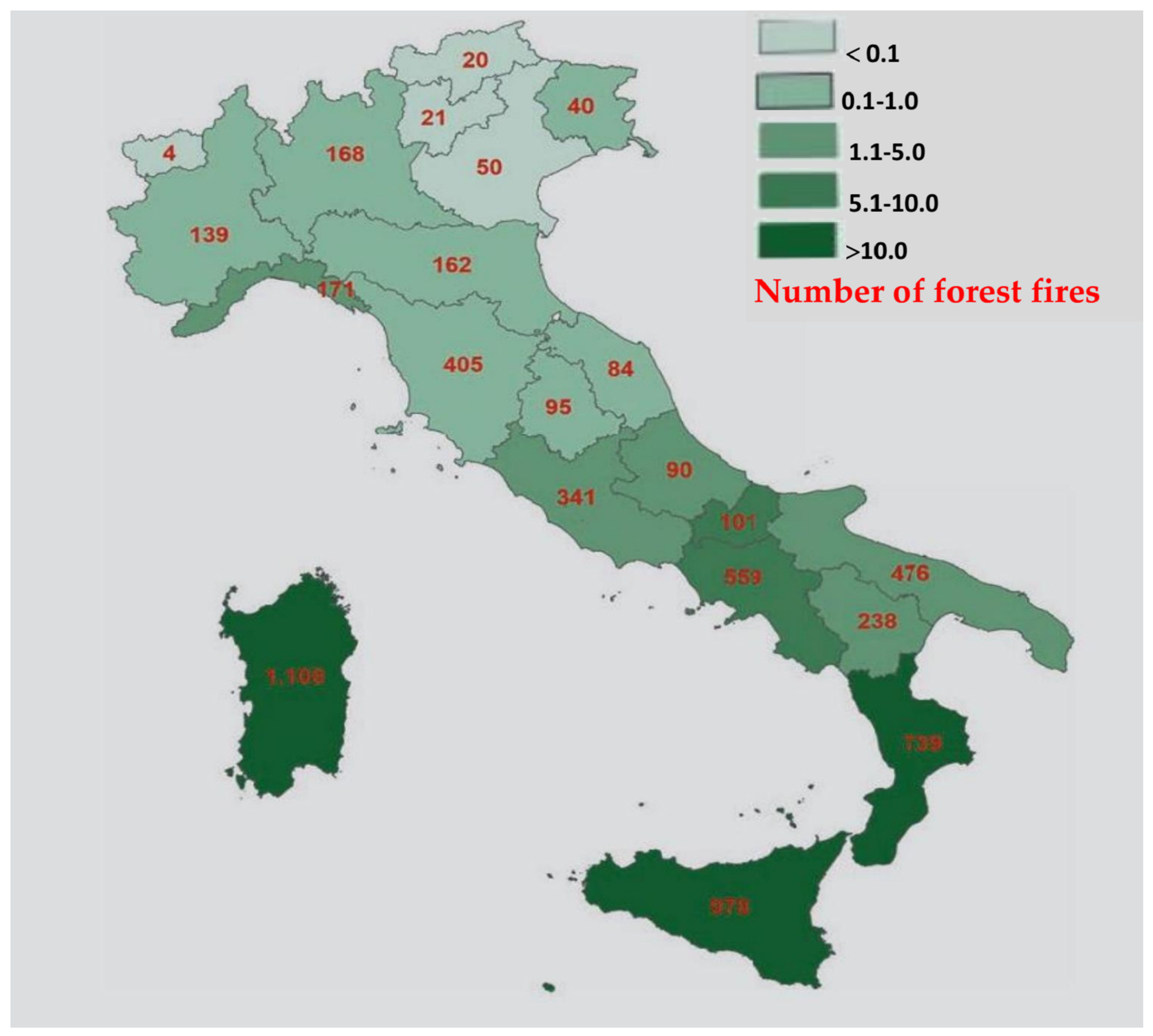
4.1. Urban Sprawl and Beyond—Data on the Phenomenon in Italy

Data from Eurostat’s Land Use and Cover Area frame Survey [26] show that 7.8 percent of Italian land is affected by the phenomenon of anthropization, which is not in line with the European average of 4.6 percent. In fact, Italy, in 2013, ranked fifth in Europe [26], preceded by Malta, Belgium, the Netherlands, and Luxembourg. In the time span of almost a century, in terms of stock, Italian residential construction has experienced a consistent and continuous growth over time: from almost two million buildings already present before 1919 to almost thirteen million, excluding the demolitions that have occurred over the years [26]. But this reading, which refers only to the increase in soil consumption related to residential building, is not exhaustive. We must, in fact, consider that there are numerous other factors that determine forms of coverage in urban areas (business and commercial centers, production activities of all orders and scales of size, infrastructure, etc.) [27,28,29] increasing the level of anthropic use [27,30].
The 2006 European Environmental Agency defined sprawl as a physical pattern of low-density expansion of large urban areas at the expense of agricultural areas and from mixed land use and suburbs. Urban sprawl and urbanization are intimately related categories. Tangible repercussions of this phenomenon, in addition to the loss of agricultural land, are higher public expenditures for the provision of endowments and services and greater use of private vehicles; as a result, the sprawl of a city and its suburbs over rural areas is considered “unsustainable” [27,28,29,31,37]. The phenomenon of urban sprawl and the phenomenon of soil consumption are closely related, but they do not have the same meaning.
Sprawl is a form of low-density sprawl [28,29,30,31,37,43], while soil consumption is the consequence, but the two-way correspondence does not apply. Soil consumption, as mentioned above, in terms of loss of naturalness and biodiversity can result from other causes, such as deforestation with crop replacement and fires, for example.
In Italy, vegetation cover in mountainous areas is declining (−0.3 percent between 2012 and 2021, or about 4600 hectares per year), probably as a result of the devastating fires that have affected the peninsula in recent years. “Land losses” are concentrated in the Islands and the Northwest, especially in the belt below 1000 m above sea level, which is most affected by soil consumption for settlement purposes. Sicilia’s percentage of degraded land is among the highest [29], reaching 19.7 percent (Table 1).
According to Ispra data, soil consumption is growing again, and in 2021, it reached 70 sq. km. of new artificial cover in a single year. The average is worrying, with 19 hectares per day, the highest value in the last ten years; it has been calculated that the speed of consumption reached 2 sq. m. per second. The artificialization of land through concrete affects 21,500 sq. km. of Italian land: of this, as much as 5400 sq. km., a territory as large as a region classified as medium-sized (such as Liguria or Piemonte) [29,30], is represented by construction, which accounts for 25 percent of the land consumed [29,30,31,32]. But that is not all. As mentioned, consumption, understood as the artificialization of land, may depend on anthropogenic processes, not necessarily related to “cement production” [29,31,32,33], meaning the construction of roads and general infrastructure and urbanization works.

4.1.1. Containing Soil Consumption and Regeneration through Planning and Landscape Design

Soil consumption of urban planning significance occurs by transforming an originally natural or semi-natural area into an area for residential, productive, and general infrastructure use.
The law on “soil consumption” approved in the House, applies to, in an “urbanized area”, the part of the territory consisting of historic centers, built-up areas with continuity of lots for residential, industrial, and artisanal, commercial, office, service or tourist-receptive use, as well as areas equipped with equipment, services or technological facilities, urban parks, lots and unbuilt interclosed spaces [29,33,34,35] equipped with primary urbanization works.
In the urban planning domain of some regional laws, the definition of “urbanized territory” is unambiguous, but it is broad, not already polysemous, when its reference is made in the context of new urban planning instruments. Especially in some regional laws [29,30], it has an exquisitely technical configuration and an “open” temporal dimension, linked to the confirmation of existing urban planning provisions in the new urban planning instruments, the maintenance of building rights, and bonus incentives (house plan/earthquake bonus to set the building sector in motion).
The General Urban Plan—provided in Art. 32 of Law 24/17 of Emilia-Romagna—identifies the perimeter of the “urbanized territory”, meaning not only the built-up areas with continuity and interclosed lots, but also the completion areas of the current plan conterminous to the urbanized territory and the undeveloped lots of urban implementation plans in progress. The same interpretation is given by RL (Regional Law) 19/02 of Calabria [30,43], the guidelines, and attached circulars.
Thus, according to the meanings described and some current regulations, in Italy land is:
-
“consumed” if artificial land cover associated with the loss of a fundamental environmental resource intervenes, or has intervened, or if the naturalness of the land has been compromised by external or anthropogenic factors (fires, deforestation);
-
“anthropized” if it has been transformed and its use is for human (anthropogenic) activities;
-
Affected by “urbanization/urban sprawl” if there is a low-density extension of large urban areas at the expense of agricultural areas and mixed land use and suburbs;
-
“urbanized” when it has pre-existing constructions of the urban planning instrument, but also all residual (unimplemented) areas of the current plan (B, C, D and F), and the undeveloped lots of detailed urban plans under implementation [30,43].
The trend of de-compaction or housing dispersion recorded in the last decade raises concerns. As pointed out by ISTAT, while between 1991 and 2001 there was a generalized trend of compaction (where densely built-up areas grow and suburban density decreases), a new progression of settlement dispersion emerged in the following decade. In 2011, consolidated built-up areas covered 6.7 percent of the territory [30,31]. Over the twenty years considered, the area grew by almost 2 percentage points, with higher progressions in the main urban realities, which represent almost one-fifth of the territory.
The result of this is the orientation to contain, preserve, limit, and reduce to zero the consumption of additional land by incentivizing “vertical” development with densification strategies and volumetric replacements [30,33,43] and promoting the reuse of the existing through special regulations and funding measures, such as regional l. no. 21 of 2008 “Norms for urban regeneration, in RL (Regional Law). no. 18 of 2019 of the Lombardia region “Simplification and incentive measures”, but also the Budget Law of 2020 that allocated, from 2021 to 2034, EUR 8.5 billion [29,30,33] to be invested in regeneration projects starting from the suburbs with the aim of making investments to reduce marginalization and degradation.
In recent years, more and more green infrastructure projects have been implemented, including green interventions with a high impact and benefits for the environment, the community, and the landscape that are instrumental to mitigating the effects of climate change and land consumption [30]. There are tested results from best practices that show that a flexible, integrated, and concrete approach is the most cost-effective from an environmental and economic point of view. However, to further improve the functioning of strategies and maximize their benefits, they must assume interconnected and interdependent actions [30]. From the study carried out, it emerges that the benefits increase significantly when a minimum level of coherence is reached between the different scales, between the interventions and the contributions actually made to reduce land consumption, making the territory resilient by optimizing the responses in terms of regeneration by favoring measures aimed at implementing green infrastructures and enhancing ecosystem services. Only in this way, and measured against a broad territorial context, can the various strategies, combined in a green key, make a significant contribution to regional development, to combating the effects of climate change, to disaster risk management [30], and to improving agriculture/forestry and the environment.

4.1.2. The Contribution Made by Ecosystem Services

Recognition of the biophysical value of nature in economic terms took its first steps with the Millennium Ecosystem Assessment (MA) initiative (2005), followed by The Economics of Ecosystems and Biodiversity, TEEB [30,31,32], a study initiated in 2007 during the G8+5 meeting, European Mapping and Assessment of Ecosystems and their Services, MAES [30,31,32], and European projects such as Life+ MNG [30,31,32] that deepened the economic assessment system. The MA addressed the following topics: changes in ecosystems, ecosystem services, and the consequences for human well-being; the status of ecosystem services and human well-being; actions to conserve ecosystems; the effectiveness of decisions affecting ecosystems and the causes of ineffectiveness; and methodologies to strengthen the assessment of ecosystems and services.
The MA has established a scientific basis for taking ecosystems into account in decision making processes and has been credited with establishing the relationship between human well-being and the environment, highlighting the fact that the degradation of nature entails damage that has a significant cost. Acting on the environment is “complex and multidimensional” [30,31,32], and the MA proposes an analytical approach to analyzing ecosystems, their state, and their impacts, offering a common method of assessment in processes involving the UNCCD (United Nations Convention to Combat Desertification), the CBD (Convention on Biological Diversity), the Ramsar Convention on Wetlands, and the Convention on Migratory Species [30,31,32,50]. The motivation behind the economic estimation of ecosystem services is not to make resources tradable but to bring out the importance of the reciprocal influences of ecosystem services and community well-being; subsequently, at the national level, countries have produced their own schemes (https://openness.hugin.com/example/cices (accessed on 2 march 2024).
In order to simplify understanding, the CICES (Common International Classification of Ecosystem Services) [31,32,50] is, for example, the framework used in the EU MAES process, which was aimed at mapping ecosystem services on a European scale, in order to fulfil the commitments made in Action 5 of the EU Biodiversity Strategy to 2020 [31,32,50]. Examples include the missions of the TEEB process [31,32,50] to estimate the value of ecosystem services and integrate it into decision making, to invest in ecological infrastructure to make the value of nature visible, i.e., communicable in a clear way, to carry out measures and mapping to improve management, to identify the relationships between nature and human well-being, and to map protected areas.
Thus, in addition to systems for calculating and monitoring the area of soil consumed, the share of landscape restored through green infrastructure, of renatured area, and the contributions to climate mitigation made by ecosystem services must be considered; this information must be quantified and monitored by making it interfaceable with other systems referred to and in use, e.g., by Ispra to quantify soil consumption. The ecosystem services assessment process complements the mapping process and allows, by improving the knowledge framework of environmental resources, us to define the most appropriate management policies, and to bring out and know the value of natural capital. Many open-source computer models for valuing ecosystem services, such as ARIES, ARtificial Intelligence for Ecosystem Services, and InVEST, Integrated Valuation of Ecosystem Services and Tradeoffs tool [31,32,50], used in many programs and initiatives, are capable of geo-referencing and valuing ecosystem services in economic and biophysical terms.
Those analyzed in the preceding paragraphs are numbers that deserve a closer look, especially if we consider that some areas of the regions show that they have been particularly affected by urbanization processes—and soil consumption with urban relevance—already since the last few decades of the last century with urban sprawl towards peripheral areas [31,32,33,34,50]; the data that emerge are apparently contrasted with the amount of land degraded or compromised by factors independent of urban sprawl, and, thus, the transformation of woods and forests into productive cultivation activities, fires and others. Sicilia, for example, ranks among the regions with the highest percentage of degraded land, caused by productive conversions, deforestation, and fires, while still managing to maintain average sprawl.
If we consider Enna, the land consumed in the province of Enna as of 2006 was 3.05%, standing at 3.11% in 2012, according to Ispra data [31,32,33,34,50]. It will be necessary to understand what concrete actions to propose to reduce soil consumption, to encourage de-impermeabilization and renaturalization, to enhance and recover fragments of (diffuse) landscape within cities, to promote fruition activities in the peri-urban system, and to understand what can be the contribution of the ecological–environmental dimension rendered through landscape enhancement for ecological transition and through urban transformation management tools [32,33,34]. It will be necessary to realize that the “stability” of city fragments within the landscape depends on the ability of the landscape to contribute to urban circular metabolism, and that the model of urban resilience can be built through the “control” of the landscape and the stability of biodiversity and “urban ecosystems”.
Ispra returned a snapshot of Italy, in the period 2000–2006 [32,33,34], in which peripheral and suburban areas grew four times faster [33,34] than urban centers. The phenomenon affected Europe, in which urban areas cover 4 percent of the surface area, but in Italy, the percentage figure was exceeded and the phenomenon of urban sprawl, or diffuse city, “implies that at least one quarter of the territory is directly involved” [34,35] in “urban use” [35]. The growth of suburban areas is not the only element characterizing the phenomenon of “urban sprawl” [36,43].
The environmental effects of “urban sprawl” include a reduction in the productivity of agricultural areas [37] and an increase in air pollution brought about by automobile use and the resulting road traffic congestion [38].
Even the vertiginous growth of intensive agriculture has had an impact on the territory and the rural landscape; alternative forms of agricultural activity linked to tourism, agri-tourism, for example, have had positive socio-economic–environmental effects both in terms of opportunities for valorization, greater knowledge of the cultural heritage, and in terms of impact—positive or negative—on the environment, on the balance of ecosystems and their services, on consumption models, and on the management of flows with respect to areas to be protected and resources to be preserved. The relaunch of tourism, and, therefore, of the economy of the territories, can take place considering the agricultural territory as an ‘opportunity’ for intelligent and sustainable development. Energy is a very significant indicator to measure the effectiveness of the measures envisaged: through the study of energy, we can identify the areas of strategic impact of the actions put in place for tourists’ enjoyment of rural areas [39], in terms of increasing environmental awareness, thus contributing to the preservation of landscapes and responses to environmental challenges in the era of “ecological transition” [40].

4.2. Interventions of Renaturalization for Resilience, Focus Sicilia

The picture that emerges sees an ongoing crisis at the global level due to factors such as pollution, climate change, soil consumption, loss of biodiversity, and risk reduction in ecosystem services. These phenomena have different dimensions and are characterized by an acceleration in the speed of processes and changes that produce impacts directly on humans or indirectly involving other environmental factors in ways and cause–effect relationships that are difficult to understand.
According to the United Nations Intergovernmental Panel on Climate Change (IPCC) study, cities are the cause of more than 75 percent of the amount of CO2 emissions estimated worldwide, and urban settlements are responsible for nearly half of the total greenhouse gas emissions produced [41,42,43]. It would seem to ascertain that this “picture”, alarming in itself, will tend to get even worse. Some estimates speculate that the process of urbanization, in densely populated countries such as China and India, for example, will increase significantly. The number of residents within built-up areas will be on the rise: by 2050, 70 percent of the world’s population will live in medium and large cities and metropolises, rising from the current 50 percent to 60 percent within a decade [42].
Absurdly, it would seem that a process of densification and growth proportional to the population’s state of distress is underway: the population on a global basis will confirm the upward trend, especially [43] where there is widespread poverty.
To incentivize nature’s reappropriation of areas taken from it, action must be taken at several levels, including reducing expansion areas and de-impermeabilizing lands through congruous and sustainable regulations and planning choices [44]. The process of “soil consumption” is difficult to stop. Some new-generation urban planning instruments have applied containment regulations to bring soil consumption to zero. What can be done, given that soil consumption is known to be the cause of increases in artificial land cover, and this can increase land vulnerabilities in light of climate change and interconnected factors that reduce responses in terms of increased resilience of cities? Nature needs to reclaim the places deputed to it. In many cities of the same region, for example, in Sicily, the causes of soil consumption are different; Enna and Palermo stand confirming the “consumption” trends of 2006, +0.16 for Palermo and +0.6 for Enna (Table 1).
The soil consumed [45] in the province of Enna (with a rural vocation) is probably linked to the cultivation transformations and the reconversion of productive types, while at the municipal level, the values are slightly higher (Table 2) because in lower Enna, the presence of the University Citadel [46] has determined a recent urban expansion [47] and the supply of student residences.
An urban reorganization of the territories will probably intervene. The current urban planning instruments in Sicilia [48], the PRG (General regulation Plan), drawn up in the implementation of RL (Regional Law) 71/78, will have to be replaced with the municipal General Urban Plan, PUG, which, in implementation of the principles of limiting soil consumption, regulates productive interventions in agricultural green areas. Not only that, RL, Regional Law, n. 19/20, provides a range of implementation tools by attributing exact legal configuration to urban regeneration interventions (regulated in Art. 33 of the recent RL). The new regulatory context solicits broad reflections, including the permanence of homogeneous zones in the two different domains—transformable areas and non-transformable areas—while pointing to paths of regulatory adaptation of the modalities in use until a few years ago.
In order to curb soil consumption in favor of urban regeneration, attention must also be turned to the recovery and redevelopment of degraded, disused, or abandoned areas; the redevelopment of urbanization in general and land endowments, connections, and contextual mobility; the use of urban equalization and compensation tools;, and the involvement of social partners in forms of participation. In order to achieve the set targets, it is necessary to ensure [17,48,54]:
-
Consistent and reliable data;
-
Improving the knowledge base and encouraging innovation;
-
Providing financial support for regeneration projects aimed at combating land consumption through ecosystem services and landscape restoration;
-
Integrating green infrastructure into policy implementation in key areas to trigger financing mechanisms across the EU [17,49,54].
Consistent and reliable data are essential for effective dissemination of actions. As part of the EU Biodiversity Strategy, together with the European Environment Agency, other Member State research bodies and agencies and other stakeholders have initiated monitoring activities and established interactive databases. There is a recognition that information is needed not only on land consumption, but also on the extent and condition of ecosystems, the services they provide, and the value of those services [49,50,51,52,53,54], so that ecosystem services are properly valued and then estimated with respect to the contribution they can make to resilience and the mitigation of the effects of climate change by promoting innovative solutions and approaches in spatial planning and decision making processes.
A minimum level of consistency should be encouraged in relation to the data used to inform these decisions, particularly for projects supported by EU funds. However, further efforts are needed to improve understanding of the links between biodiversity (species/habitat) and ecosystem condition (viability, resilience and productivity) and its capacity to provide ecosystem services.
The transnational continuity of geographical features such as mountain ranges (e.g., the Alps and Pyrenees), vegetation cover (e.g., forests) and river basins (e.g., the Rhine and Danube) [50,51,52,53,54], which are part of the EU’s natural and cultural heritage and common identity, indicates that identity features, environmental problems, and solutions transcend national borders. For example, the European Green Belt initiative is an ecological network that aims to harmonize relations between human activities and the natural environment by increasing opportunities for socio-economic development in the area from the Barents Sea to the Black Sea [50,51,52,53,54]. In the TEN-T policy, already from its genesis, green infrastructure was conceived as an integral part of the proposed corridor projects. Strategies, to be effective, cannot have administrative limits, must be coordinated and joint, and must aim at a pan-European vision.

5. Conclusions

The policy documents and case studies cited, which are almost always empirical experiences, provide a useful reconnaissance to identify the most effective approach in terms of design solutions and strategies to be implemented in order to contain soil consumption through ecosystem services, landscape restoration, and its residual fragments within the existing city. In our research, we point out that this effort requires joint and integrated action and that this can take place within the urban regeneration processes envisaged by European planning, encouraged in the various fora by the various environmental protection organizations and scientific communities. All the initiatives mentioned have a high level of specialization and sectorization, and this is an obvious limitation. According to this approach, within the regeneration processes, it is necessary to define the individual actions (material and immaterial: de-impermeabilization/renaturalization, naturalistic engineering works for flood defense, implementation of green infrastructures in urban areas, ecological restoration of floodplain forests and woods in extra-urban areas) and the strategic impact areas (society, environment, climate, biodiversity, economy, etc.). Many factors are linked to certain environmental phenomena in a cause–effect relationship that has, at times, blurred boundaries even though they interact. Building resilience and improving our defenses against adverse events is an important point of the strategy to reduce land consumption, but it is clear that this strategy is a necessary but not sufficient condition. Specific action needs to be linked to something else.
It can be linked to green infrastructure (managing flows from floods and overflows can be achieved by strengthening and optimizing the relationship between green infrastructure and watercourses), to ecosystem services (economic estimation of the contribution of ecosystem services and benefits becomes a complementary support tool), and to punctual actions to restore landscape fragments in urban areas. The combination of the various measures leads to a reduction in landscape fragmentation and forest degradation, but it can also contribute to ensuring the conservation status of species and habitats and improving the provision of related ecosystem services, fostering a sense of community, and helping combat social exclusion and segregation. Clearly, all this needs to be monitored (using the tools described in the previous paragraphs), both to understand the trend state of the phenomena analyzed and to understand what the “response” of the interventions actually is in the implementation phase and measure it against the expectations set.
One of the aspects through which counteracting soil consumption generates positive effects is the protection of the land and the environment. This also has effects on the agricultural sector, as stopping the artificialization of the soil means addressing and promoting sustainable forms of use. In the management of their activities, “green” farmers use environmentally friendly practices, including composting of waste, use of renewable energy, recycling of materials, and the use and sale of zero-mile organic products. In this way, the sustainability “chain” takes shape, helping to preserve the environment and natural resources. At the same time, forms of rural tourism (rural farm) are encouraged [17,54], with a strong identity connotation, respecting the territory, the landscape and its peculiarities. Through the use of traditional techniques and practices, those involved in traditional agricultural production also offer opportunities to promote sustainable education by raising awareness of the environment [17,54] and encouraging an “intelligent and slow” use of the land. Through workshops and educational activities, users can put sustainable farming practices into practice, learn the importance of biodiversity, and reduce energy consumption [17,54]. These types of experiences contribute to forming more responsible citizens by making them aware of the importance of a sustainable lifestyle and offer numerous benefits to both guests and local communities.
The various modes of sustainable tourism also offer a significant experience, contributing to the enhancement of local cultures and the development of rural economies [17,54]. The 2030 Agenda, with its 17 goals, emphasizes the importance of implementing (Goal 11) ‘Sustainable Cities and Communities’. There are numerous ecosystem services—regulating and producing, but also recreational and cultural—that can ensure the livability and stability of ecosystems by combining protection [17,54] and sustainable development.
But is the situation global? While this has been a global phenomenon, Europe has been not an exception. Since 2010, urban expansion in the continent has led to a significant conversion of agricultural land, driven by the surging demand for housing, infrastructure, and commercial development. This conversion has had far-reaching implications for the agricultural sector and the environment. The loss of fertile farmland has impacted food production and sustainability, posing challenges for Europe’s food security. Factors like population growth, urbanization, and economic development contribute to this trend, with transportation network expansion further fueling the demand for land conversion. While urban expansion brings [17,54] economic growth and improved infrastructure, it also threatens food production, biodiversity, and environmental sustainability. Efforts such as land use planning, conservation measures, and promoting sustainable agriculture have been implemented to address these challenges. However, balancing the needs of urbanization with the preservation of agricultural resources on ecological–environmental fronts is essential for long-term food security and sustainable land use practices.
In addition, it is fundamental for future generations to understand the contribution of the ecological–environmental dimension in the fight against climate change and the ecological transition of cities. This can also be achieved through the enhancement of the landscape, the implementation of land de-impermeabilization criteria [17,54] and the management of meteoric water flows, the reintroduction of certain techniques of environmental restoration [17,54] and ‘naturalistic’ architecture, and the use of particular natural or recovered materials and native tree and shrub essences. The protection of landscape areas combined with some forms of sustainable use [17] can help reorganize and implement the offer of services and equipped green areas [17]. The forest favors the absorption of CO2, and a network of urban gardens [17,54] could help the “urban landscape economy”.

Author Contributions

Conceptualization, C.F., F.M., K.M.N., B.A.-R. and A.A.; methodology, C.F. and F.M.; validation, C.F., F.M., K.M.N., K.M.N., B.A.-R. and A.A.; investigation, C.F., F.M., K.M.N., B.A.-R. and A.A.; writing—original draft preparation, F.M., C.F. and K.M.N.; writing—review and editing, C.F. and K.M.N.; visualization, C.F.; supervision, F.M. The authors collaborated in the drafting of the following paragraphs, in order: Abstract and Section 1 are of all authors (C.F., K.M.N., B.A.-R., A.A. and F.M.); Section 2, Section 2.1 and Section 2.2 are of C.F. and F.M.; Section 3, Section 3.1 and Section 3.2 are of C.F.; Section 3.3 is of K.M.N.; Section 4, Section 4.1.1 and Section 4.2 are of C.F.; Section 4.1.2 are of C.F., K.M.N. and F.M.; Section 5. is all authors (C.F., K.M.N., B.A.-R., A.A. and F.M.). All authors have read and agreed to the published version of the manuscript.

Funding

This research received no external funding.

Data Availability Statement

Data are contained within the article.

Conflicts of Interest

The authors declare no conflicts of interest.

References

  1. Istat, Forme, Livelli e Dinamiche dell’Urbanizzazione in Italia. ISTAT. 2017. Available online: https://www.istat.it/it/files//2017/05/Urbanizzazione.pdf (accessed on 6 June 2023).
  2. Munafò, M. (Ed.) Consumo di Suolo, Dinamiche Territoriali e Servizi Ecosistemici. Edizione 2022. Report SNPA 32/22. 2022. Available online: https://www.snpambiente.it/snpa/consumo-di-suolo-dinamiche-territoriali-e-servizi-ecosistemici-edizione-2022/ (accessed on 8 June 2023).
  3. ISPRA. Corine Land Cover, Anni 2000, 2012 e 2018, Corine Land Cover—Italiano. Available online: https://www.isprambiente.gov.it/it/attivita/suolo-e-territorio/suolo/copertura-del-suolo/corine-land-cover (accessed on 8 June 2023).
  4. ISPRA-SNPA. Carta Nazionale del Consumo di Suolo 2022, Rapporto Nazionale “Consumo di Suolo, Dinamiche Territoriali e Servizi Ecosistemici. Edizione 2022”—Italiano. 2022. Available online: https://www.isprambiente.gov.it/it/archivio/eventi/2022/07/presentazione-del-rapporto-nazionale-201cconsumo-di-suolo-dinamiche-territoriali-e-servizi-ecosistemici-edizione-2022201d (accessed on 20 June 2023).
  5. COM(2012) 710 Final. COM/2013/0249_Communication from the Commission to the European Parliament, The Council, The European Economic and Social Committee and the Committee of the Regions, Green Infrastructure (GI)—Enhancing Europe’s Natural Capital, EUR-Lex—52013DC0249—EN—EUR-Lex. Available online: https://europa.eu (accessed on 13 February 2024).
  6. Bruxelles, 24.5.2019 COM(2019) 236 Final. RELAZIONE DELLA COMMISSIONE AL PARLAMENTO EUROPEO, AL CONSIGLIO, AL COMITATO ECONOMICO E SOCIALE EUROPEO E AL COMITATO DELLE REGIONI Riesame dei Progressi Compiuti Nell’attuazione della Strategia dell’UE per le Infrastrutture Verdi. Available online: https://eur-lex.europa.eu/legal-content/IT/TXT/PDF/?uri=CELEX:52019DC0236&qid=1562053537296#:~:text=Le infrastrutture verdi sono definite,ampio spettro di servizi ecosistemici (accessed on 13 February 2024).
  7. Baldini, M. Le Infrastrutture blu e Verdi Nelle Città Aumentano la Connettività degli Habitat, in Le Infrastrutture blu e Verdi Nelle Città Aumentano la Connettività degli Habitat e Favoriscono la Biodiversità|AboutPlants. 2023. Available online: https://www.aboutplants.eu/notizie/paesaggio/Le-infrastrutture-blu-e-verdi-nelle-citta-aumentano-la-connettivita-degli-habitat (accessed on 30 October 2023).
  8. Formez, Macro-Attività Realizzazione Azione di Sistema. Politiche Pubbliche e Rigenerazione Urbana: Un Quadro Ricostruttivo, Formez. 2021. Available online: https://formez.it (accessed on 5 October 2023).
  9. Istat, Rapporto SDGs 2023. Informazioni Statistiche per l’Agenda 2030 in Italia, ISTAT, Roma. 2023. Available online: https://www.istat.it/storage/rapporti-tematici/sdgs/2023/Rapporto-SDGs-2023.pdf (accessed on 5 October 2023).
  10. ASVIS, Le Infrastrutture Verdi Nelle Città a Dieci Anni dalla Legge Sugli Spazi Verdi Urbani, Position Paper, ASVIS, Dicembre 2023, Il Position Paper dell’ASviS a Dieci Anni dalla Legge sul Verde Urbano. Available online: https://asvis.it/public/asvis2/files/Pubblicazioni/PositionPaper/2023/PositionpaperASviSInfrastruttureVerdiDEF.pdf (accessed on 30 October 2023).
  11. Bergantino, A.S.; Di Liddo, G.; Porcelli, F. A Relative Measure of Urban Sprawl for Italian Municipalities Using Satellite Light Images; Forthcoming on Applied Economics; Working papers SIET 2018–ISSN 1973-3208. Available online: http://www.sietitalia.org/wpsiet/2018_Bergantino.pdf (accessed on 30 December 2023).
  12. Carraro, C. (Ed.) Cambiamenti Climatici, Infrastrutture e Mobilità; Ministero delle Infrastrutture e della Mobilità Sostenibili (MIMS): Roma, Italy, 2022; Cambiamenti climatici, infrastrutture, mobilità ‹Trasformazioni—Il Blog di Carlo Carraro›.
  13. Ispra, Consumo di Suolo, Dinamiche Territoriali e Servizi Ecosistemici, Edizioni. 2018. Available online: https://climate.copernicus.eu (accessed on 6 June 2023).
  14. European Commission, Copernicus Climate Change Service—C3S, and European Centre for Medium-Range Weather Forecasts—ECMWF. Heat Wave Days and Heat Related Mortality for Nine European Cities Derived from Climate Projections. 2021. Available online: https://cds.climate.copernicus.eu/cdsapp#!/software/app-health-urban-heat-relatedmortality-projections?tab=app (accessed on 10 September 2023).
  15. Borie, A.; Micheloni, P.; Pinon, P. Forme urbane e siti di meandri. In Casabella, I Terreni Della Tipologia; 1985; number 509–510. [Google Scholar]
  16. Ispra, Annuario dei dati Ambientali, Edizione 2012. ISPRA, Roma Annuario dei dati Ambientali 2012—Italiano. Available online: https://www.isprambiente.gov.it/it/pubblicazioni/stato-dellambiente/annuario-dei-dati-ambientali-2012 (accessed on 10 September 2023).
  17. Territorial Agenda of the European Union 2020. Towards an Inclusive, Smart and Sustainable Europe of Diverse Regions. Informal Ministerial Meeting of Ministers Responsible for Spatial Planning and Territorial Development. 19 May 2011, Hungary. Available online: https://www.tandfonline.com/doi/pdf/10.1080/14649357.2012.707391 (accessed on 13 February 2024).
  18. Reports, Studies and Review Documents Supported by the European Commission. Available online: http://ec.europa.eu/environment/nature/ecosystems/studies.htm (accessed on 13 February 2024).
  19. European Commission. Brussels, 6.5.2013 COM(2013) 249 Final, See Case Examples of GI Creating Jobs in Table 2 of Commission Services Working Document (SWD(2013) 155 Final). Available online: https://eur-lex.europa.eu/resource.html?uri=cellar:d41348f2-01d5-4abe-b817-4c73e6f1b2df.0014.03/DOC_1&format=PDF (accessed on 13 February 2024).
  20. European Commission, Communication from the Commission to the European Parliament, the Council, the European Economic and Social Committee and the Committee of the Regions. A Community Approach to the Prevention of Natural and Man-Made Disasters, COM(2009) 82 Final. OJ L 2003, 1, 65. Available online: https://eur-lex.europa.eu/LexUriServ/LexUriServ.do?uri=COM:2009:0082:FIN:EN:PDF (accessed on 13 February 2024).
  21. AAVV, Natura, Paesaggio e Sviluppo del territorioNatura 2000. Provincia di Bolzano, Rete Natura. 2000. Available online: https://provincia.bz.it (accessed on 13 February 2024).
  22. European Commission. Green Infrastracture. Available online: http://ec.europa.eu/environment/nature/ecosystems/docs/adaptation_fragmentation_guidelines.pdf (accessed on 13 February 2024).
  23. Spano, D.; Mereu, V.; Bacciu, V.; Barbato, G.; Buonocore, M.; Casartelli, V.; Ellena, M.; Lamesso, E.; Ledda, A.; Marras, S.; et al. I Cambiamenti Climatici in sei Città Italiane; Fondazione Centro Euro-Mediterraneo sui Cambiamenti Climatici CMCC: Lecce, Italy, 2021; Available online: https://www.doi.org/10.25424/cmcc/analisi_del_rischio_2021 (accessed on 10 September 2023).
  24. European Commission. Connecting Smart and Sustainable Growth through Smart Specialisation. 2012. Available online: https://www.researchgate.net/publication/312532217_Connecting_Smart_and_Sustainable_Growth_through_Smart_Specialisation_-_A_practical_guide_for_ERDF_Managing_Authorities (accessed on 13 February 2024).
  25. Pavia, R.; Clementi, A. Territori e Spazi Delle Infrastrutture; Ed. Interspazi: Ancona, Italy, 1998. [Google Scholar]
  26. Travisi, C.M.; Camagni, R.; Nijkamp, P. Impacts of urban sprawl and commuting: A modelling study for Italy. J. Transp. Geogr. 2010, 18, 382–392. [Google Scholar] [CrossRef]
  27. Iaione, F.C. La città come bene comune. Aedon 2023, 1, 31–40. [Google Scholar]
  28. Carruthers, J.I.; Ulfarsson, G.F. Does smart growth matter to public finance? Urban Stud. 2008, 45, 1791–1823. [Google Scholar] [CrossRef]
  29. MA, Ecosystems and Human Well-Being: A Framework for Assessment. Available online: https://millenniumassessment.org (accessed on 2 February 2024).
  30. FAO and ITPS. Global Soil Organic Carbon Map (GSOCmap) Technical Report; FAO: Rome, Italy, 2018; 162p, Available online: https://www.fao.org/3/I8891EN/i8891en.pdf (accessed on 2 February 2024).
  31. Carruthers, J.I.; Ulfarsson, G.F. Urban sprawl and the cost of public services. Environ. Plan. B Plan. Des. 2003, 30, 503–522. [Google Scholar] [CrossRef]
  32. Haines-Young, R.; e Potschin, M. Classificazione dei Servizi Ecosistemici. 2013. Available online: https://openness.hugin.com/example/cices (accessed on 10 September 2023).
  33. Carruthers, J.I. The impacts of state growth management programmes: A comparative analysis. Urban Stud. 2002, 39, 1956–1982. [Google Scholar] [CrossRef]
  34. Ispra, Consumo di Suolo, Dinamiche Territoriali e Servizi Ecosistemici. Rapporto ISPRA n.288, 2018. Consumo di Suolo, Dinamiche Territoriali e Servizi Ecosistemici. Edizione 2018—Italiano. Available online: https://www.isprambiente.gov.it/it/pubblicazioni/rapporti/consumo-di-suolo-dinamiche-territoriali-e-servizi-ecosistemici.-edizione-2018 (accessed on 10 September 2023).
  35. Camagni, R.; Gibelli, M.C.; Rigamonti, P. I Costi Collettivi della Città Dispersa; Alinea: Firenze, Italy, 2002. [Google Scholar]
  36. Calafati, A.G. Economia della città dispersa. Econ. Ital. 2003, 1, 215–230. [Google Scholar]
  37. Bruederle, A.; Hodler, R. Nighttime lights as a proxy for human development at the local level. PLoS ONE 2018, 13, e0202231. [Google Scholar] [CrossRef] [PubMed]
  38. Brueckner, J.K. Urban sprawl: Diagnosis and remedies. Int. Reg. Sci. Rev. 2000, 23, 160–171. [Google Scholar] [CrossRef]
  39. Turri, E. Il Paesaggio Come Teatro; Marsilio Editore: Venezia, Italy, 1998. [Google Scholar]
  40. Altinok, E.; Cengiz, H. The effects of Urban Sprawl on Spatial Fragmentation and Social Segregation in Instabul. In Proceedings of the 44th ISOCARP Congress, Dalian, China, 19–23 September 2008. [Google Scholar]
  41. Haggblade, S.; Hazell, P.; Reardon, T. The rural non-farm economy: Prospects for growth and poverty reduction. World Dev. 2010, 38, 1429–1441. [Google Scholar] [CrossRef]
  42. Jaeger, J.A.G.; Bertiller, R.; Schwick, C.; Cavens, D.; Kienast, F. Urban permeation of landscape and sprawl per capita: New measures of urban sprawl. Ecol. Indic. 2010, 10, 427–441. [Google Scholar] [CrossRef]
  43. Moraci, F.; Fazia, C. Ambiguità degli effetti delle discipline regionali sul consumo di suolo zero e sulla verticalità in architettura/Ambiguous efects of regional regulations on zero soil consumption and on verticality in architecture. Technè 2019, 17, 78–95. [Google Scholar]
  44. AAVV, Millennium Ecosystem Assesment, ISPRA, Millennium Ecosystem Assessment—Italiano. Available online: https://isprambiente.gov.it (accessed on 10 September 2023).
  45. Papa, R.; Galderisi, A.; Vigo Majello, M.C.; Saretta, E. European Cities Dealing with Climate Issues: Ideas and Tools for a Better Framing of Current Practices. TeMA-J. Land Use Mobil. Environ. 2015, Special Issue ECCA 2015, 63–80. [Google Scholar] [CrossRef]
  46. Paulsen, K. The Effects of Land Development on Municipal Finance. J. Plan. Lit. 2013, 29, 20–40. [Google Scholar] [CrossRef]
  47. Gibelli, M.C.; Salzano, E. (Eds.) No Sprawl, Perché è Necessario Controllare la Dispersione Urbana e il Consumo di Suolo; Alinea: Firenze, Italy, 2006. [Google Scholar]
  48. Shi, M.; Janowicz, K.; Cai, L.; Mai, G.; Zhu, R. A socially aware huff model for destination choice in nature-based tourism. AGILE GIScience Ser. 2021, 2, 14. [Google Scholar] [CrossRef]
  49. Maechler, S.; Boisvert, V. Valuing Nature to Save It? The Centrality of Valuation in the New Spirit of Conservation. Glob. Environ. Politics 2024, 24, 10–30. [Google Scholar] [CrossRef]
  50. Mathew, P.V. Sustainable tourism development: Discerning the impact of responsible tourism on community well-being. J. Hosp. Tour. Insights 2022, 5, 987–1001. [Google Scholar]
  51. Zhou, L.; Hu, F.; Wang, B.; Wei, C.; Sun, D.; Wang, S. Relationship between urban landscape structure and land surface temperature: Spatial hierarchy and interaction effects. Sustain. Cities Soc. 2022, 80, 103795. [Google Scholar] [CrossRef]
  52. Barton, H.; Grant, M. A health map for the local human habitat. J. R. Soc. Promot. Health 2006, 126, 252–253. [Google Scholar] [CrossRef] [PubMed]
  53. Khan, J.; Hildingsson, R.; Garting, L. Sustainable Welfare in Swedish Cities: Challenges of Eco-Social Integration in Urban Sustainability Governance. Sustainability 2020, 12, 383. [Google Scholar] [CrossRef]
  54. Unione Europea, Verso un’Europa più Verde e Sostenibile. Available online: https://european-union.europa.eu/priorities-and-actions/actions-topic/environment_it (accessed on 13 February 2024).
Figure 1. Forest area covered by fires per 1000 square kilometers and in red the number of fires, Source: Figure 13. Elaboration of SDGs 2023 Report on data from the Comando Carabinieri Tutela forestale (accessed on 10 September 2023).
Land 13 00323 g001
Figure 2. Methodological steps of the study.
Land 13 00323 g002
Figure 3. Percentage share of regional degraded land net of water bodies (UNCCD methodology for SDG 15.3.1 indicator) year 2019. Source: Ispra and SDGs Report 2023, ISTAT, Rome (accessed on 10 September 2023).
Land 13 00323 g003
Table 1. Soil consumption by province, Figures for the two cities of Palermo and Enna are highlighted in green, Regione Sicilia. Source: Ispra.
Regione Sicilia
Provincia:
Soil Consumption 2006 [%]Soil Consumption 2006 [Hectares]Soil ConsumptionSoil Consumption 2012 [Hectares]Increase 2006–2012 [Net Annual Soil Consumption in Hectares]Soil Consumption 2021 [Hectares]Increase 2020–2021 [Net Annual Soil Consumption in Hectares]
Trapani7.3718.173 7.5518.601 428.15 19.120 43.09
Palermo5.4026.9815.5627.780798.8728.41966.37
Messina5.7718.727 5.8719.044 317.08 19.572 30.30
Agrigento5.4316.540 5.6517.197 657.60 17.603 27.41
Caltanissetta4.519.607 4.649.889 282.20 10.209 36.13
Enna3.057.8153.117.957141.708.21566.06
Catania7.3526.104 7.6827.279 1.175.13 28.118 59.06
Ragusa9.7515.744 10.1516.399 654.97 17.116 96.52
Siracusa8.5318.002 8.8318.650 647.18 19.217 62.23
Table 2. Soil consumption in the province of Enna, Figure for the two city of Enna is highlighted in green. Regione Sicilia. Source: Ispra.
Regione Sicilia
Provincia Enna
Comune:
Soil Consumption 2006 [%]Soil Consumption 2006 [Hectares]Soil ConsumptionSoil Consumption 2012 [Hectares]Increase 2006–2012 [Net Annual Soil Consumption in Hectares]Soil Consumption 2021 [%]Soil Consumption 2021 [Hectares]Increase 2020–2021 [Net Annual Soil Consumption in Hectares]
Agira3.15003.2517.918.383.354210.15
Aidone1.73491.7351.472.31.73630.90
Assoro3.84213.8428.126.643.94412.10
Barrafranca5.02705.1274.865.215.42881.37
Calascibetta3.02693.0268.930.273.02700.10
Catenanuova12.614112.7142.291.513.11460.14
Centuripe3.15303.1529.7403.15431.24
Cerami1.91792.0186.937.582.11995.38
Enna3.612923.71325.9833.683.813543.23
Gagliano Castelferrato3.31823.3183.461.353.31916.14
Leonforte3.73123.9323.8111.423.93283.77
Nicosia3.26883.2702.0813.853.475418.51
Nissoria3.32033.3204.631.733.42132.16
Piazza Armerina3.19313.2955.4924.723.29816.50
Pietraperzia2.52892.5290.551.812.52970.06
Regalbuto2.44042.4411.597.662.54201.33
Sperlinga1.91091.9110.020.971.91140.06
Troina2.74512.7451.811.182.74622.01
Valguarnera Caropepe10.910211.0103.190.8111.11040.00
Disclaimer/Publisher’s Note: The statements, opinions and data contained in all publications are solely those of the individual author(s) and contributor(s) and not of MDPI and/or the editor(s). MDPI and/or the editor(s) disclaim responsibility for any injury to people or property resulting from any ideas, methods, instructions or products referred to in the content.

