Abstract
Woody plants in roadside green spaces of rural settlements provide a wide range of ecosystem functions and services. The study presented in this paper was conducted in three rural settlements in Western Slovakia, representing three different rural landscape types—lowland, basin, and mountainous landscapes. The assessed woody vegetation is situated in diverse settlement structures, with various spatial patterns. A comprehensive woody plant assessment was conducted in selected central streetscapes of three model settlements, examining spatial, compositional, visual, aesthetic, and other values, as well as the characteristics of woody plants. These attributes were clustered according to five main functions and fourteen value parameters and the results were assigned to three quality categories, to objectivise a qualitative woody plant assessment in roadside vegetation structures in the countryside. The findings show the level of suitability of woody plants based on how they fulfil aesthetic, compositional, climate, safety, cultural, and historical functions.
1. Introduction
Slovakia has many different landscape types with highly diverse spatial patterns and morphology [1]. It is among the most urbanised countries in Europe based on the correlation between the overall area of the country and the number of settlements. In total, there are 2927 settlements, including 2749 rural settlements. Rural settlements and their cadastral territories cover 95.44% of the overall area of Slovakia. Thus, Slovakia can be defined as a characteristic rural country with different production types, which is reflected by the size, shape, urban form, and spatial patterns of settlements [1,2,3,4]. In terms of morphology and landscape relief, Izakovičová [3] defines three main landscape types: lowland, basin, and mountainous landscapes. Mountainous landscapes are the prevailing landscape type in Slovakia, covering up to 53% of the overall area. Lowlands represent 29%, while the lowest proportion is covered by basin landscapes that represent 18% of the overall territory.
All landscape types in Slovakia have diverse conditions for development and growth determined by their settlement and landscape structure. The most significant developments can be observed in lowland and basin landscape types, determined by favourable natural ecosystems and intensive anthropogenic pressures. Natural ecosystems have been transformed by urbanisation, industrialisation, and the construction of artificial technical works in the landscape. Rural settlements have also been intensively affected by the development of agriculture [4]. Population growth causes significant pressures on rural landscapes through the diversification of living and housing needs. An uncoordinated mass urbanisation, neglecting the aesthetic and natural values of the countryside, as well as historical heritage and legacy, can lead to significant irreversible damages to the landscape [5]. Urban expansion, the excessive use of natural resources, intensive agricultural practices, industrial infrastructure, and land uptake contribute to the degradation and gradual loss of the local identity of rural landscapes [6]. This pressure on rural landscapes can be mitigated through a rational territorial planning and landscape management, which also contributes to the preservation of the main rural landscape characteristics and functions [7,8]. According to the Council of Europe Landscape Convention, landscape is defined as perceived by people and characterised as a result of mutual influence and interactions between natural and/or human factors [9]. It is therefore important to adjust land use to biodiversity, natural systems, and green infrastructure in rural landscapes [10,11] and integrate this approach both into policy-making [12] and planning processes [13].
Development of cultural landscapes has always been of interest in landscape history studies. From this perspective, it is important to know and understand how the dynamic settlement development respects historical landscape values and how it will be implemented in landscape protection and management strategies [11,14]. All landscape types have a characteristic spatial morphology, representing the prevailing land use, industry, production, urbanisation, and other activities throughout the historical development. The spatial morphology, urban form, and the overall settlement structure, including the spatial arrangement of streets, define the landscape type as shown in Figure 1, Figure 2 and Figure 3.
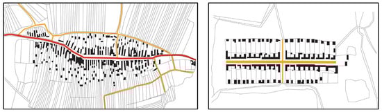
Figure 1.
Typical spatial pattern and morphology of settlements in lowland landscapes—village situated directly on the main road marked with red line, which is the main urban and compositional axis of the settlement (left) and street-type village situated off the main road, where the main axis is an isolated local street marked with wide orange line (right) [15], graphically edited by authors.
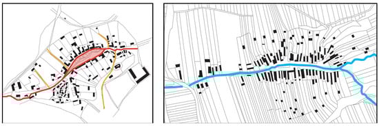
Figure 2.
Typical spatial pattern and morphology of settlements in basin landscapes—village on the main road that extends in the village centre to a spindle-form square marked with red colour (left) [16], village on the river marked with blue line (right) [15].
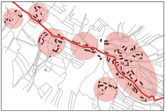
Figure 3.
Typical spatial pattern and morphology of settlements in mountainous landscapes—chain-structure colony village with a chain of small settlement structures marked with red ellipses organised along a main road marked with red line [16].
The structural and morphological variability of rural settlements in Slovakia is reflected by a diverse functional and spatial organisation of the urban form. This has led to a differentiation of functional zones in settlements, represented by typical features related to land use, shape, and the spatial and structural organisation of the urban form. Settlements are interconnected by a system of streets and roads, including static and dynamic traffic, green spaces, blue spaces, and natural formations in the landscape structure [13,17].
Characteristic functional zones in rural settlements include gathering, representative and social spaces, open spaces in front of administration and polyfunctional buildings, service centres, cultural centres, central zones, squares, and compact spatial patterns of different uses [4]. Zones providing recreational and cultural functions include compact green spaces such as parks, waterfronts, and other green spaces in the built-up area [4,10]. Functional zones dedicated to mobility and transportation include streetscapes, pedestrian paths, cycle trails and objects of static and dynamic transportation [17]. An efficient spatial organisation of these functional zones is of crucial importance [18]. Transportation corridors connect different functional zones throughout the settlement structure, and they belong to open spaces with the highest frequency of use. Streets and transportation corridors of all levels are highly important for a fast, safe, and effective mobility, which is combined with a higher pollution by emissions, vibrations, noise, dust, heavy metals, diverse particulars, oil, and fuel from motor vehicles as well as soil compaction and related reduced water infiltration [17,19].
Public green spaces as one of the main functional zones of rural settlements characterised above play a crucial role for the overall quality of life in small towns and villages [20]. The importance of public green spaces and vegetation structure of streetscapes can be defined at diverse levels of effectiveness:
- Green spaces reduce pollution mechanically through capturing dust particulars by the assimilation organs, habitus, and bark of woody plants. This happens both physically and chemically. The chemical capture of particles is important mainly for heavy metals, exhalates, and emissions [21].
- Green spaces, especially trees, serve as an optical reduction of unattractive views, provide protection against negative weather impacts, and play a role in safety, orientation, and guiding functions in the urban space [22,23].
- Green spaces, especially trees, effectively regulate climate and physical processes in the urban area [24]. Woody plants can regulate the temperature at roads and other surfaces in the streetscape.
- Green spaces regulate soil and air humidity in several height levels of the streetscape profile [24,25].
- Green spaces influence light conditions, especially the light intensity, quality, and spectrum [26].
- Green spaces serve as nature-based solutions for an effective rainwater management [27,28,29].
From a historical perspective, streets are among the most characteristic indicators of settlement transformations and development in time and space [30]. Traditionally, streets were created within settlement structures along with buildings and technical infrastructure. In the course of time, the accompanying open spaces of transportation corridors have been changed and modified, including the establishment of roadside and street vegetation or (bio)technical infrastructure for stormwater management [17,23]. The species composition, as well as the amount of woody vegetation and its organisation in the composition of linear and aerial groups has been impacted by changes in the use of space, the application of technical constructions, and the intensification of use, which was reflected by the quantity and species composition of woody plants [31,32].
Roadside vegetation is situated in all functional zones of the countryside and stands for an important element of the overall landscape and village character [31,32,33,34]. The rural environment and ecosystems are constantly changing and are significantly impacted by climate change [35,36]. There are novel strategies to deal with these changes [37,38], which will better adapt to the changed environment, while fulfilling its ecosystem functions and services. However, it is very important to find an effective balance between the architectural specificities of the countryside and the uniqueness of landscape types and characters, as historical landscape structures are important sources of cultural and historical heritage in cultural landscapes that enhance the identity of the landscape [39,40,41].
In terms of planning, there is a strong linkage between preserving cultural heritage and cultural landscape sustainability [42,43]. Global climate change inducing a higher frequency of extreme weather events, has however proved to be an important threat for the sustainability of many heritage sites worldwide [44]. The implementation of a suitable adaptation policy is therefore needed to address ongoing climate change and natural hazards [45]. The diversity and identity of cultural landscapes is manifested in the correlation between local landscape elements and landscape composition in a wider spatial context, which is important for reading the landscape and the ability of planners and designers to enhance local identity and cultural landscape values [46]. Contemporary trends in European landscape development are well known but planning and managing future landscape remains still complex and uncertain. Through the processes in and the management of historical landscape structures and their symbolical meaning, landscapes can provide valuable knowledge and a more sustainable planning and management for future landscapes [9,47].
The species composition and distribution of woody plants reflect the cultural and historical development of a settlement, as well as the interest of local governments and inhabitants in their environment, including public open spaces [48]. The diversity of settlement structures in different morphological landscape types causes a higher woody plant species diversity [49,50], which occurs either as autochthonous species in natural vegetation formations or as allochthonous species of different varieties and cultivars [32,50]. An important period was the introduction of woody plant species and application of generally less known species and cultivars. Their occurrence in Slovak public spaces increased significantly in the 1970s and 80s. This period impacted not only private and semi-private spaces, but it also significantly changed public open spaces [51]. This intensive introduction of new species often caused an uncoordinated planting design and spatial distribution of woody plants. Woody plants from this period are today important components of public open spaces. They co-form all visual and aesthetic characteristics of public open spaces.
Vegetation cover, including woody plants and their species composition and distribution significantly changes according to the landscape type [52,53]. Landscape types of Slovakia are thoroughly specified by Činčura [52,54], Izakovičová [3], Špulerová et al. [55] and other authors who categorize main landscape types into lowland, basin, and mountainous landscapes with subtypes differentiated by their overall altitude and other patterns and features—lowlands (altitude: 0–30 m.a.s.l. for flatlands; 30–150 m.a.s.l. for uplands), basin landscape types (150–500 m.a.s.l.), and mountainous landscapes (altitude: 500–640 m.a.s.l. for low mountain ranges; above 640 m.a.s.l. for high mountain ranges). The altitude of a settlement has a direct impact on the potential natural vegetation and species composition of trees and shrubs. Slovakia is among the countries with the highest landscape variability in terms of altitude and geomorphological formations in different landscape types [41], which is directly related to a higher structural and species diversity of woody plants. Geomorphological formations are also specified by climate regionalisation, which is reflected by the species composition of woody plants occurring in a certain area, referred to as endemic species. All landscape types, regions, and settlements have typical woody plant species, representing the area. Lowland landscape types with an altitude between 30 and 150 m.a.s.l. are represented by the following autochthonous tree species: Acer campestre L., Acer platanoides L., Alnus glutinosa L., Fraxinus angustifolia L., Fraxinus excelsior L., Tilia cordata Mill., Tilia platyphyllos Mill., Quercus robur L., and Quercus cerris L. Prevailing autochthonous woody plant species in basin landscape types with an altitude between 150 and 300 m.a.s.l. are Acer pseudoplatanus L., Ulmus laevis L., Carpinus betulus L., Tilia platyphyllos L., Pinus sylvestris L., and Fraxinus excelsior L. Prevailing autochthonous woody plant species in mountainous landscape types with an altitude between 300 and 640 m.a.s.l. are Acer pseudoplatanus L., Fagus sylvatica L., Sorbus aucuparia L., Pinus cembra L., Pinus mugo L., Pinus sylvestris L., Picea abies L., Abies alba L., and Larix decidua L. [56].
The aim of the presented study was to assess woody plants in public open spaces of selected streetscapes in rural settlements, with a focus on the values and attributes of woody plants, functions of roadside vegetation, and species composition of woody plants in streetscapes. The overall quality of woody plants was evaluated using quality categories of woody plants according to their values and attributes and the level of the fulfilment of main roadside vegetation functions. The study was conducted in three model rural settlements in Western Slovakia.
2. Materials and Methods
2.1. List of Symbols Used in the following Paragraphs
M—model areas/municipalities (M1–M3: M1—Dvory nad Žitavou, M2—Čachtice, M3—Moravské Lieskové, part Brestové).
V—values/attributes of woody plants assessed in this research (V1–V14: V1—woody plants coverage, V2—height potential of trees, V3—height potential of shrubs, V4—visual connectivity, V5—composition, V6—species diversity, V7—species authenticity, V8—origin, V9—shape, V10—colour, V11—utility, V12—cultural and historical value, V13—age/development stage, V14—vitality of woody plants, for a detailed description of V1–V14 see Section 2.3).
Q—quality categories (A–C: A—best, B—average, C—worst, N/A—not applicable).
F—functions (F1–F5: F1/aesthetic and representative f., F2/proportional and spatial f., F3/climate-regulation f., F4/cultural and social f., F5/transport, and safety f.).
2.2. Characterisation of the Model Areas
The presented research was conducted in representative rural settlements located in Western Slovakia (Figure 4), which according to morphometric and morphological relief types represent three different landscape types—lowland, basin and mountainous, see Figure 1, Figure 2 and Figure 3.
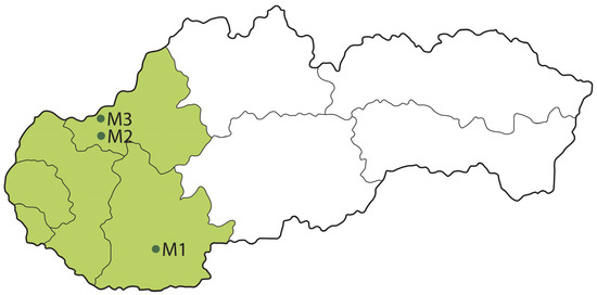
Figure 4.
Localisation of selected model rural settlements in Western Slovakia (green colour in the map)—M1—Dvory nad Žitavou, M2—Čachtice, M3—Moravské Lieskové, part Brestové.
The model area in the lowland landscape type is represented by the rural settlement Dvory nad Žitavou (M1). With 5015 inhabitants it is the 16th largest rural municipality in Slovakia [2,4]. In terms of spatial pattern and morphology, this settlement represents a combination between two types—village on the main road and street-type village, see Figure 1. This spatial structure is typical for the Danube Lowland, which is characterised by a high-density of built-up areas with small gaps and a regular organisation of local communications. Local roads follow the shape of the main road in the settlement, which is one of the key features of this settlement type. The municipality has an average altitude of 120 m.a.s.l.
The model area in the basin landscape type is the rural settlement Čachtice (M2), which is located at the border between the Trenčín Basin and the periphery of the Danube Lowland at an altitude of 203 m.a.s.l. The municipality is the 48th most populated rural settlement in Slovakia, with a population of 3884 inhabitants in 2020. In terms of spatial pattern and morphology, Čachtice is a combination between two types: village on the main road and the spindle-form village with a square, see Figure 1 and Figure 2. This spatial disposition is typical for sub-mountainous areas and basin landscape types, where local streets follow the main road, leading to important towns and cities, castles on business roads, and significant historical sites, while creating a lenticular central open space—a square and the local communications extend in a spindle shape around the main communication.
The model area in the mountainous landscape type is the rural settlement Moravské Lieskové, part Brestové (M3), located at the foothills of the White Carpathians at an altitude of 249 m.a.s.l., with a population of 2568 inhabitants (in 2020). The settlement Moravské Lieskové, part Brestové is a chain-structure colony village, see Figure 3. This typical spatial pattern occurs mainly in mountainous areas of linear character. It is characteristic for settlements created during German colonisation and by an adaptation of local inhabitants to the landscape character [57].
The potential natural vegetation in all three model settlements is represented by the following prevailing woody plant species. The most probable occurrence of woody plant species within the assessed cadastral territory are underlined.
The potential natural vegetation of M1—Dvory nad Žitavou, consists of willow-poplar forests in floodplains of large rivers (softwood floodplain forests), oak and cerium-oak forests, ash-elm-oak forests in the basins of large rivers (hardwood floodplain forests), and Carpathian oak-hornbeam forests. The following woody plant species may occur in the landscape based on the surrounding forest types: Acer campestre L., Acer tataricum L., Carpinus betulus L., Cerasus avium (L.) Moench., Corylus avellana L., Crataegus monogyna Jacq., Fagus sylvatica L., Ligustrum vulgare L., Cornus mas L., Fraxinus angustifolia Vahl, Fraxinus angustifolia Vahl subsp. danubialis, Fraxinus excelsior L., Padus avium Mill., Populus alba L., Populus nigra L., Quercus robur L., Quercus petraea (Mattusch.) Liebl. agg., Quercus cerris L., Salix alba L., Swida sanguinea (L.) Opiz., Sorbus torminalis (L.) Crantz, Tilia cordata Mill., Ulmus laevis Pall., and Ulmus minor Mill.
The potential natural vegetation of M2—Čachtice, consists of ash-elm-oak forests in the basins of large rivers (hardwood floodplain forests), lowland hygrophilous oak-hornbeam forests, alder forests in the floodplains of submountain and mountain streams, Carpathian oak-hornbeam forests. The following woody plant species may occur in the landscape based on the surrounding forest types: Acer campestre L., Acer pseudoplatanus L., Acer tataricum L., Alnus glutinosa (L.) Gaertn., Alnus incana (L.) Moench., Carpinus betulus L., Cerasus avium (L.) Moench., Corylus avellana L., Crataegus monogyna Jacq., Fagus sylvatica L., Fraxinus angustifolia Vahl subsp. danubialis, Fraxinus excelsior L., Padus avium Mill., Populus nigra L., Quercus robur L., Quercus petraea (Mattusch.) Liebl. agg., Ribes uva-crispa L., Tilia cordata Mill., Sambucus nigra L., Sorbus torminalis (L.) Crantz, Ulmus laevis Pall., Ulmus minor Mill., Swida sanguinea (L.) Opiz., and Viburnum opulus L.
The potential natural vegetation of M3—Moravské Lieskové, part Brestové, consists of Carpathian oak-hornbeam forests, oak-cerium forests, and ash-alder submountain floodplain forests. The following woody plant species may occur in the landscape based on the surrounding forest types: Acer campestre L., Acer pseudoplatanus L., Alnus glutinosa (L.) Gaertn., Alnus incana (L.) Moench., Cerasus avium (L.) Moench., Carpinus betulus L., Corylus avellana L., Cornus mas L., Fagus sylvatica L., Fraxinus excelsior L., Ligustrum vulgare L., Lonicera xylosteum L., Quercus petraea agg., Quercus cerris L., Quercus robur agg, Ribes uva-crispa L., Sambucus nigra L., Swida sanguinea (L.) Opiz., Tilia cordata Mill, Padus avium Mill., Prunus spinosa L., Rubus sp. L., and Viburnum opulus L.
2.3. Assessed Model Settlements and Reference Areas
The assessed areas in each model rural settlement were adjacent green spaces of local main roads. These green spaces significantly contribute to the aesthetic, cultural, historical, and functional representation of the municipality. Adjacent green spaces of local communications selected for assessment intersect the village centre from one end to the other. These spaces are impacted by the highest traffic load and frequency, as documented in the National Traffic Census in 2015 elaborated according to the Methodology of National Traffic Census Conduction and Evaluation approved by the Ministry of Transport and Communications of the Slovak Republic on 30.6.2015, published in 2016.
M1—Dvory nad Žitavou, is situated on the A-class main road I/75 (Figure 5). The assessed road section is 450 m long. The average daily traffic intensity is as follows: T—trucks with trailers (923), O—cars (4973), and M—motorcycles (31), with a total of 5927 vehicles per day on average, see Figure 5.
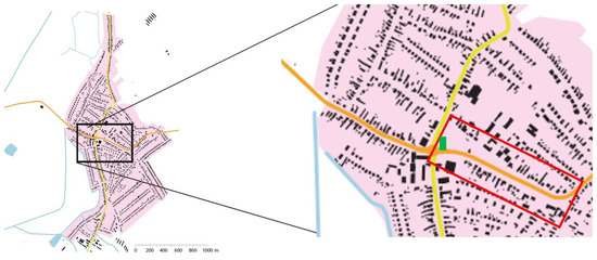
Figure 5.
Location of the assessed road section in the municipality of Dvory nad Žitavou. The black rectangle on the left shows the urban centre, the red rectangle on the right shows the assessed road section. The green rectangle marks the Saint Vojtech Bishop Church, which is the main architectural landmark of the settlement.
M2—Čachtice, is situated on the B-class main road II/504 (Figure 6). The assessed road section is 520 m long. The average daily traffic intensity is as follows: T—trucks with trailers (631), O—cars (7509), and M—motorcycles (34), with a total of 8174 vehicles per day on average, see Figure 6.
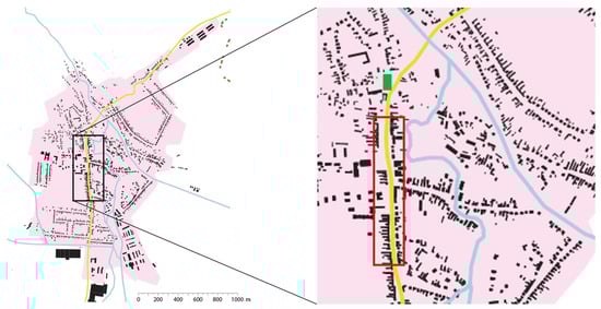
Figure 6.
Location of the assessed road section in the municipality of Čachtice. The black rectangle in the left shows the urban centre, the red rectangle in the right shows the assessed road section. The green rectangle marks the church as the main architectural landmark of the settlement.
M3—Moravské Lieskové, part Brestové, is situated on the A-class main road I/54 (Figure 7). The assessed road section is 670 m long. The average daily traffic intensity is as follows: T—trucks with trailers (1437), O—cars (6280), and M—motorcycles (30), with a total of 7747 vehicles per day on average, see Figure 7.
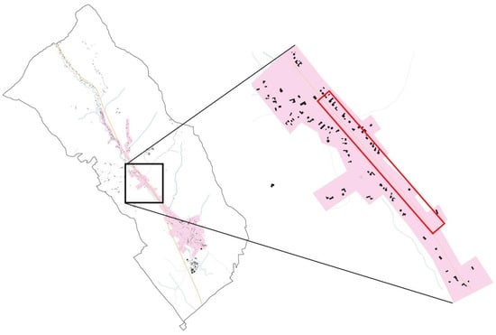
Figure 7.
Location of the assessed road section in the municipality of Moravské Lieskové—part Brestové. The black rectangle on the left shows the urban centre, the red rectangle on the right shows the assessed road section.
The presented research focused on the assessment of roadside green spaces and vegetation, with a particular focus on woody plants and their performance in monitored functions, in the public open space of streetscapes in all three model areas (M1–M3). The assessed linear green spaces have a width of up to 30% of the length of assessed road sections. Based on a comprehensive literature review on the main principles of green space design in the countryside [4,32,57,58,59], the most important values and attributes of woody plants were identified and collected. These attributes are directly linked to the main functions of woody plants in rural public open spaces. The main values/attributes of woody plants (V1–V14) identified by literature review are listed in Table 1. These are rated and classified into three quality categories (Qx) as shown in Table 2. The main functions of woody plants (F1–F5) are listed in Table 3. These attributes characterise the spatial, compositional, visual, and aesthetic values of woody plants in public open spaces in the countryside. The origin of woody plants (V8) is assessed in line with the Act on Nature and Landscape Protection No. 543/2002 [60]. The vitality of woody plants (V14) is assessed using the methodology by Pejchal [61]. The value of each attribute has been calculated using the following formula (expressed in percentage):
Vx = Vxb/Vxa × 100 (%)

Table 1.
Values/attributes of woody plants in rural public open green spaces.
Table 2.
Quality categories (Qx) of woody plant attributes and values (Vx).
Table 3.
Functions (Fx) of roadside vegetation in public open spaces of rural settlements.
The qualitative values/attributes of woody plants (V1–V14) listed in Table 1 were qualitatively evaluated based on the following principles:
V1—woody plants coverage—a high canopy coverage of woody plants in roadside green spaces reduces noise and dust generated by intensive traffic. It creates shade and spatially complements the streetscape. The shrub layer captures heavy metals, fuel, and mineral oil residues [33].
V2 and V3—the height potential of trees (V2) and shrubs (V3), are limited by technical infrastructure (overhead power and telecommunication lines, streetlights, public municipal radio, and other infrastructure elements). In linear roadside vegetation it is desirable to fulfil the height potential to a maximum extent, while not jeopardising the technical infrastructure [33].
V4—visual connectivity—a spatial and visual connection of woody plants to surrounding open spaces, buildings, and landmarks. The visual linkage between woody vegetation in the public space and front gardens of private buildings. Woody plants can support views and vistas, frame historical monuments, and hide visually unattractive objects. Woody plants support the readability and visual clarity of the public space [31,33].
V5—composition—a spatial composition of woody plants that respects landscape-architectural compositional principles of spatial distribution in relation to surrounding buildings and open spaces and in line with the compositional aim of the streetscape design. Woody plants complement the streetscape composition in regular or irregular groups and formations [31,33].
V6—species diversity—in roadside linear green spaces, it is preferable to have a lower number of woody plant species for a better optical guidance of streetscape users and for traffic safety. A less diverse roadside woody vegetation line positively contributes to the visual unification of the streetscape [32].
V7—species authenticity—the authenticity of woody plant species in roadside green spaces regarding geographic region, climate zone, and rural landscape character. Original domestic tree species, especially endogenous species with natural canopy forms and shapes have the highest authenticity and are in line with the local landscape character and scenery [1,30,32].
V8—origin—based on their geographic origin, woody plant species can be (a) original domestic, (b) introduced domesticated, (c) introduced partially domesticated, and (d) potentially introduced (rare) [32,51,56,60].
V9—shape—in rural streetscapes in the countryside, it is preferable to use species with natural shapes, with a canopy set higher on the stem. Modified canopy shapes (e.g., globose or columnar) look unnatural and foreign in the landscape and open space [33].
V10—colour—in rural streetscapes in the countryside, it is preferably to use mainly green colour shades. Acceptable are short-term and seasonal colour accents of leaves, blossom, and fruits. A prevailing green colour of vegetation looks harmonious and does not disturb the landscape character [33].
V11—utility—in linear woody vegetation formations in streetscapes, it is preferable to have trees with a lower reproduction capacity and smaller fruits, and it is preferable to avoid fruit trees close to roads for safety and operational reasons, however utility values are in line with the traditional landscape character of productive rural landscapes and are considered positively if they do not negatively impact traffic safety [33].
V12—cultural and historical value—the cultural heritage and historical legacy of trees as natural monuments, their linkage to historical objects and monuments, including sacred buildings, small sacred architecture, and other monuments, and the symbology of woody plants in relation to the local landscape character, site specificity, and local identity [17,26,30].
V13—age/development stage—the preferred age and vitality categories of woody plants are (5) old, (4) mature, and (3) stabilised adolescent individuals. The other age categories of (2) growing and (1) new plantings fulfil roadside woody vegetation functions to a lower extent [33,61].
V14—vitality of woody plants—woody plants with (1) optimal or (2) slightly reduced vitality in terms of physiological, bio-mechanical, and landscape quality are preferred to woody plants with a reduced vitality ranging from 3 to 5 according to the level of vitality reduction [61].
Based on the above values/attributes, woody plants were assessed and qualitatively evaluated. The overall value of the assessed road section represents the share of suitable/preferable woody plants (Table 1, column 3/Vxb) in proportion to the total number of woody plants in the respective road section (Table 1, column 2/Vxa), which was calculated using Equation (1).
The level of fulfilment of an overall value/attribute of a woody plant and its functions was evaluated in three quality categories (Table 2) based on Equation (1).
To achieve the A-best quality category, the value must normally achieve 81–100%, but for value V10 (colour) a stricter threshold has been defined, as this value is particularly important for the accompanying (linear) woody vegetation of roads, where according to general design principles, it is recommended to have minimal deviation from (neutral) green colours to support visual unity and integrity of a tree line or alley. For value V6 (species diversity), a threshold of up to 10% was defined for the same reason, to support the visual unity of attributes and characteristics of woody plants in the compositional complexity of a tree line or alley.
Further assessed was how woody plants fulfil the main functions of roadside woody vegetation, see Table 3.
F1—The aesthetic and representative function of roadside vegetation consists in the ability of vegetation to visually enhance streetscapes and create attractive and representative public open spaces through vegetation colours, shapes and forms, texture, and structure.
F2—The proportional and spatial function of roadside vegetation consists in the ability of vegetation to spatially complement public open spaces, their structure, spatial composition, and architecture. Authentic and proportional roadside vegetation can effectively complement the local landscape character and architecture.
F3—The climate-regulation function of roadside vegetation consists in the ability of vegetation to regulate microclimate, airflow, air and surface temperature, air and soil humidity, light, and shade.
F4—The cultural and social function of roadside vegetation consists in the ability of vegetation to fulfil cultural and social needs. Vegetation can enhance cultural and historical relations and connections. It can support the importance and symbology of buildings, including sacred architecture, cultural and historical monuments.
F5—The transport and safety function of roadside vegetation consists in the ability of vegetation to serve as safety barriers, guiding elements for road users, and dividing the traffic space from pedestrian paths and routes.
This was assessed based on Table 4, which states, what quality category (A–C) defined by Table 2 needs to be achieved to fulfil (⬤/ff) a function of roadside vegetation (F1–F4) listed in Table 3, which quality category fulfils a function at least partially (◖/pf), and when a function is not fulfilled at all (◯/nf) or when the quality category of values does not have an impact on the fulfilment of a function (N/A), see Table 4.
The interrelation between values/attributes (V1–V14) and functions (F1–F5) was evaluated for each model area (M1–M3). This interrelation represents the level of fulfilment of roadside vegetation functions by woody plant values (V1–V14) and their quality categories (A–C) according to the methodology by Mell [62] as fulfilled, partially fulfilled, and not fulfilled, see Table 4.
The level of the fulfilment of roadside vegetation functions by woody plants was qualitatively evaluated using the qualitative evaluation method of Frequency Factor [50] through Equation (2) as follows:
where FF is the percentual expression of the fulfilment of a function (F1–F5) by woody plant values/attributes (V1–V14) to a certain level (ff—fulfils, pf—partially fulfils, nf—does not fulfil). LFn is the number of values/attributes (V1–V14) which fulfil a function to a certain level (ff—fulfils, pf—partially fulfils, nf—does not fulfil) and Vt is the total number of values/attributes (V1–V14), where there is an interrelation between values/attributes of woody plants and the functions of roadside vegetation.
FF = LFn/Vt × 100 (%)
3. Results
Identified and Documented Woody Plant Species
The total surface of the assessed area in M1—Dvory nad Žitavou is 8542 m2, out of which 5245 m2 is covered by woody plants (61.40%). In total, 157 woody plants were documented, including 144 trees (91.72%) and 13 shrubs (8.28%). The following species were identified: Aesculus hippocastanum L. (23), Acer pseudoplatanus L. (6), Acer platanoides L. (2), Acer saccharinum L. (2), Betula pendula L. (3), Carpinus betulus ’Fastigiata’ (61), Fraxinus excelsior L. (3), Juglans regia L. (21), Negundo aceroides Moench (1), Quercus robur ‘Fastigiata’ (14), Sophora japonica L. (1), Tilia cordata Mill. (6), Tilia platyphyllos L. (1), Thuja occidentalis ‘Smaragd’ (13), and Photinia x fraseri ‘Red Robin’ (13). Four tree species are in accordance with the potential natural vegetation of this area: Carpinus betulus L., Fraxinus excelsior L., Quercus robur L., and Tilia cordata Mill., see Figure 8 and Figure 9. For a detailed overview of woody plant species composition see Supplementary Material Table S1.
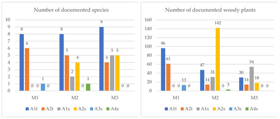
Figure 8.
Number of documented woody plant (tree and shrub) species and total number of documented woody plants (trees and shrubs). M1–M3—three model areas, A1t—original domestic tree species, A2t—introduced domesticated tree species, A1s—original domestic shrub species, A2s—introduced domesticated shrub species, A3s—introduced partially domesticated shrub species, A4s—potentially introduced (rare) shrub species.
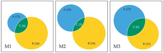
Figure 9.
Venn diagrams showing the correlation between the number of (A) real woody vegetation species based on field research, and (B) potential woody vegetation species based on the Potential Natural Vegetation and the surrounding forest types in all three model areas (M1–M3). (C) is the overlap of (A,B) and represents the number of woody vegetation species defined as potential natural vegetation that were documented during field research.
The total surface of the assessed area in M2—Čachtice is 1824 m2, out of which 854 m2 is covered by woody plants (46,82%). In total, 237 woody plants were documented, including 61 trees (25.74%) and 176 shrubs (74.24%). The following species were identified: Acer platanoides ‘Globosum’ (6), Aesculus hippocastanum L. (2), Carpinus betulus L. (1), Fraxinus ornus ’Meczek’ (26), Fraxinus excelsior ‘Altena’ (3), Picea glauca ‘Conica’ (1), Robinia pseudoacacia ‘Umbraculifera’ (4), Robinia pseudoacacia L. (3), Taxus baccata ‘Fastigiata’ (6), Thuja occidentalis ‘Smaragd’ (2), Thuja occidentalis ‘Malonyana’ (3), Thuja orientalis ‘Aurea Nana’ (3), Tilia cordata ‘Rancho’ (2), Tilia cordata ‘Roelvo’ (4), Tilia cordata Mill. (4), Tilia platyphyllos Scop. (1), Juniperus x media ‘Pfitzeriana Aurea’ (3), Ligustrum vulgare ‘Lodense’ (25), Philadelphus ‘Lemoinei’ (10), and Ribes sanguineum ‘Pulborough Scarlet’ (128). Three tree species are in accordance with the potential natural vegetation of this area: Carpinus betulus L., Fraxinus excelsior L., and Tilia cordata Mill., see Figure 8 and Figure 9. For a detailed overview of woody plant species composition see Supplementary Material Table S1.
The total surface of the assessed area in M3—Moravské Lieskové—part Brestové is 5295 m2, out of which 1480 m2 is covered by woody plants (27,95%). In total, 116 woody plants were documented, including 44 trees (37.93%) and 72 shrubs (62.07%). The following species were identified: Acer campestre L. (4), Betula pendula Roth (5), Fraxinus excelsior L. (5), Picea abies (L.) H. Karst. (2), Pinus nigra J.F. Arn. (2), Populus nigra L. (1), Prunus domestica L. (1), Pyrus communis L. emend. Burgsd. (9), Salix alba L. (1), Thuja plicata ‘Zebrina’ (1), Thuja occidentalis ‘Malonyana’ (2), Tilia platyphyllos Scop. (3), Tilia cordata Mill. (8), Corylus avellana L. (15), Clematis vitalba L. (12), Forsythia x intermedia ‘Minigold’ (2), Chamaecyparis lawsoniana ‘Alumii’ (1), Chaenomeles japonica (Thunb.) Lindl. (3), Prunus laurocerasus ‘Nana’ (10), Rosa canina L. (10), Rubus idaeus L. (2), Spiraea x vanhouttei ‘Renaissance’ (2), and Swida sanguinea (L.) Opiz. (18). Six woody plant species are in accordance with the potential natural vegetation of this area: Acer campestre L., Fraxinus excelsior L., Tilia cordata Mill., Corylus avellana L., Rubus idaeus L., and Swida sanguinea (L.) Opiz., see Figure 8 and Figure 9. For a detailed overview of woody plant species composition see Supplementary Material Table S1.
The correlation between the number of woody plants and the overall area was assessed in all three model areas. The highest relative number of woody plants was documented in model area M2 (12.99%), followed by M1 (1.84%) and M3 (1.4%). The results of the evaluation of values/attributes (V1–V14) in model area M1 (Table 5) show that ten assessed values (V2–V6, V8–V11, and V14) are in the quality category A (71.43% of the total number of assessed values/attributes of woody plants). The overall composition of the space (V5) was rated as good. Woody plants respect the requirements for accompanying vegetation of main roads, with a sufficient visual connection (V4) to the St. Vojtech Bishop Church as the main architectural landmark of the village centre. Woody plants fulfil a sufficient height potential (V2), given the height limits created by overhead power lines in certain sections of the road and public lighting along the entire length. The shrub layer (V3) forms a sufficient height barrier alongside the main road. Species diversity (V6) is sufficiently represented and creates a visual unity of the tree alley, while fulfilling the qualitative attribute of originality (V8), which is 92%, represented by domestic and domesticated species. Some of the species also fulfil the utility value (V11), such as Tilia cordata Mill., and Tilia platyphyllos L. The visual value of woody plants represented by colour (V10) and canopy shape (V9) is in line with the general principles for species selection for roadside vegetation, which is prevailed by main species with natural canopy colours and shapes. Most of the woody plants (94% of the overall number) are vital (V14). The Q category B includes attributes V1, V7, V12, and V13, which represent 28.57%. A lower Q category is caused by a lower coverage of woody plants in the roadside vegetation (V1), which is 61.40% of the overall assessed road section. The species authenticity regarding the specific landscape type (V7) was not completely in line with the potential natural vegetation, see Table 4. Species corresponding with the lowland landscape type were slightly prevailing (54%). Category B is represented by the attribute V12 (cultural and historical value of woody plants), which was assessed based on historical documents, especially maps showing the historical route, see Figure 10. This route led alongside the St. Vojtech Bishop Church and was reflected also by roadside vegetation, where old individuals of Aesculus hippocastanum L. were identified and documented (11 trees). This historical tree line was disturbed at some points by gaps or other tree species, which complicates the perception and identification of the historical context on site. The alley of Aesculus hippocastanum L. continues along the park at the St. Vojtech Bishop Church, which was supported by evidence from an aerial photograph from 1950, see Figure 10. The quality of current vegetation (V13) is decreased by young tree and shrub plantings, which currently do not fulfil the desired quality of functions in space, however they reflect the local interest in public open spaces and their maintenance.
Table 5.
Values/attributes of woody plants (V1–V14) in the model areas (M1–M3) classified in three quality categories (Q) as follows: A—best, B—average, C—worst.
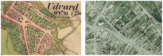
Figure 10.
The assessed road section in model area M1 on a historical military map from 1869 (left) and on an aerial photograph from 1950 (right) shows the main street with the architectural landmark of Saint Vojtech Bishop Church that dominates the streetscape. The aerial photograph on the right depicts the historical horse chestnut alley. Source: Mapire Arcanum [63] (left), TU Zvolen [64] (right).
The model area M2 in the basin landscape type that prevailed in the Q category A with a representation of 71.43%. This category includes woody plants with quality attributes V2–V6, V8–V11, and V14. Most of the woody plants fulfilled their height potential (V2, V3) given the spatial limits such as overhead power lines and road transport equipment. The composition of the woody plants (V5) of roadside vegetation forms a consistent tree line, with a clear visual connection to the main cultural and historical landmark of the village—the St. Ladislav Church with a Gothic chapel. Visual linkages to the Baroque Golgotha from 1620 and the Baroque Marian column from 1742 are completed by Tilia cordata Mill., which frame the cultural and historical monuments. The species diversity (V6) is relatively low (8%), which results in a visually unified vegetation line. The aesthetic values (V9 and V10) represented by the shape of canopies and colour of vegetation, create a visually unified roadside linear vegetation. The species composition consists of domestic and domesticated woody plants (V8), with a certain degree of utility value, such as Tilia cordata ‘Roelvo’, Tilia cordata Mill., and Tilia platyphyllos Scop. Species with a high vitality (V14) have a high share in the assessed area (98%). The quality of roadside vegetation is reduced by interruptions in the line of woody plants (V1), with a canopy coverage of 46%, which belongs to Q B. A threshold Q value A was reached in the attribute V13, where mature and old individuals of trees prevailed (78%). The overall quality of roadside vegetation is reduced by the shrub layer and young plantings of Juniperus x media ‘Pfitzeriana Aurea’ Ligustrum vulgare ‘Lodense’, Philadelphus ‘Lemoinei’, and Ribes sanguineum ‘Pulborough Scarlet’, which decrease the value/attribute V12 around cultural and historical monuments. The species authenticity of woody plants reaches a Q C regarding the basin landscape type (8%), see Table 4.
In model area M3, the attributes V2, V8, V10, and V11 reached the Q A (28.57%). The height potential of woody plants (V2) reaches a sufficient height frame of the road. Woody plants were in line with attribute V8, as mainly domestic and domesticated woody plant species are represented, which is linked to authenticity (V10) in colours and the utility value (V11) of natural woody plant species. Attributes V1, V3–V7, and V14 (50% of all attributes) reached Q B. The canopy coverage (V1) is 28%, caused mainly by relatively extensive gaps without woody vegetation. The woody plant height potential (V3) is not sufficient, as mainly low plantings cover the area: Forsythia x intermedia ‘Minigold’, Chenomeles japonica (Thunb.) Lindl., Prunus laurocerasus ‘Nana’, Rosa canina L., Spiraea x vanhouttei ‘renaissance’, and Swida sanguinea (L.) Opiz. The woody plant composition (V5) consists of scattered groups of woody plants largely without a clear compositional aim, which also relates to the visual connection of woody plants (V4) with the surrounding urbanised space and landscape. There is a relatively high species diversity (V6), which is to a significant extent (50%) in line with the landscape type (V7). Vital woody plants (V14) represent 55% of the overall vegetation cover. Attributes V9, V12, and V13 are rated as Q C. The canopy shape authenticity is 47%. The evaluated woody plants are without cultural and historical connection (V12) to the assessed area. Young individuals represent a prevailing part (64%) of the woody plant composition (V14).
In model area M1, the functions were fulfilled (ff) as follows: F2—proportion and space (ff = 72.73%), F1—aesthetics and representation (ff = 69.23%), F5—transport and safety (ff = 66.67%), culture and history (ff = 62.50%), and the lowest value F3—climate regulation (ff = 55.56%). Due to a relatively low species diversity (V6), the aesthetic and representative (F1), as well as proportional and spatial functions (F2) were fulfilled, as a lower species diversity in roadside alley plantings might be generally considered positive in terms of aesthetics. Species diversity (V6) has an indirect impact on other visual and aesthetic values of woody plants, as it determines the level of visual unity/diversity. On the other hand, for functions such as climate regulation (F3) or transport and safety (F5), the lower species biodiversity (V6) can be considered as a negative attribute. In model area M1, all functions were fulfilled (ff) or partially fulfilled (pf).
In model area M2, all functions were fulfilled similarly to model area M1. We have documented differences in partial fulfilment (pf) or no fulfilment (nf). Insufficient or no fulfilment (nf) was determined in three functions F1, F4, and F5. This was caused by species authenticity (V7) regarding the landscape type. All other attributes and their corelation with functions fulfilled partially (pf) were the same as in model area M1.
In model area M3, the following functions were fulfilled (ff): the transport and safety function (F5/33.33%), followed by the functions F4 (25.00%), F1 (23.08%), and F3 (22.22%), while the least fulfilled was the proportional and spatial function (F2/18.19%). A lack (nf) occurred in shape authenticity (V9), directly linked to aesthetics and composition. The transport and safety function (F5), as well as the cultural and historical value (V12), were negatively influenced by low shrubs and compact conifer cultivars. All functions (F1–F5) were negatively affected by woody plants in an early life phase, especially newly and recently planted woody plants. For a detailed interpretation of the results for model areas M1 to M3 see Table 6 and Table 7.
Table 6.
Quality of woody plants according to functions F1–F5 in model areas M1–M3.
Table 7.
Percentual expression of function fulfilment by woody plants in all three model areas.
The aesthetic and representative function (F1) was best fulfilled by model areas M1 and M2 (69.23%), while model area M3 performed poorly in this function (23.08%). Also, other functions (F2–F5) were fulfilled (ff) by model areas M1 and M2 (F2 = 72.73%, F3 = 55.56%, F4 = 62.5%, F5 = 66.67%). The aesthetic and representative function (F1) as well as the cultural and social function (F4) were not fulfilled in model areas M2 and M3. Model area M3 also performed poorly in fulfilling the proportional and spatial function (F2/27.27%), climate-regulation function (F3/11.11%), and transport and safety function (F5/16.67%). Model area M1 performed the best in these terms, as the category “not fulfilled” (nf) was not documented for any of the functions.
The average fulfilment rate (ff) of functions F1–F5 was as follows: M1 and M2 (65.34%) and M3 (24.36%). Model area M3 achieved, at the same time, the highest average rate in the category of insufficient or no fulfilment (nf) in functions F1–F5 (20.63%), due to which model area M3 performed at the weakest quality level. Model area M2 achieved a non-fulfilment (nf) rate of 3.20%, while model area M1 was not rated with a non-fulfilment rate (nf) at all. Therefore, model area M1 performed the best in fulfilling all of the functions of woody plants and achieved the highest green-space and woody-plant quality rate.
4. Discussion
The diversity of settlement structures, in various morphological landscape types [3,32,52,55], is related to a high species diversity of autochthonous plants in the form of natural vegetation, combined with introduced species and their varieties and cultivars. This has been verified through the presented research in all three assessed model areas M1, M2, and M3. Most domestic and domesticated woody plant species identified in model area M3 (66.66%) can be justified by the localisation in a mountainous landscape type, which is a natural source for the succession as well as intentional introduction of woody plants from the open landscape to the urbanised area [58]. In model area M3, the prerequisite of implementing a wider range of original authentic woody plants in line with the landscape type has been fulfilled. In some sectors, woody plants have a natural character, grouped in original formations or sporadically mixed-in planted cultures. Species identified in this area are in line with the potential natural vegetation—Acer campestre L., Fraxinus excelsior L., Tilia cordata Mill., Corylus avellana L., Rubus idaeus L., and Swida sanguinea (L.) Opiz. The linear woody vegetation is without a conceptual order, spread throughout the whole assessed area [49,65], which justifies the lowest areal coverage (27.95%) when compared to model areas M1 (61.40%) and M2 (46.82%).
The compositional configuration of woody plants had negative impacts in model area M3, especially on aesthetic (F1) and spatial (F2) functions. This is related to visual linkages between woody plants and the dominant landmarks of the settlement, the streetscape lining, and the coverage of surrounding, visually unappealing objects, and spaces. On the contrary, these functions were better fulfilled in model areas M1 and M2, where the woody plant coverage was fulfilled partially in all assessed functions. The amount of autochthonous woody plants was lower in these areas (M1 = 53.33%; M2 = 50.00%), however, this had no significant negative impacts on the landscape type, as the core of the composition was created mainly by autochthonous tree species. The only negative impact on the overall quality of green spaces was caused by groups of lower shrub vegetation. The only tree species that were in accordance with the potential natural vegetation were Carpinus betulus L., Fraxinus excelsior L., and Tilia cordata Mill.
A designed roadside vegetation is obvious in model areas M1 and M2, which consisted in some parts of young, yet perspective species. Due to spatial limitations, in some parts of model area M1, thin cultivars and forms were planted (Carpinus betulus ’Fastigiata’, Quercus robur ‘Fastigiata’). In model area M2 globose forms were planted due to the overhead power lines (Acer platanoides ‘Globosum’, Fraxinus ornus ‘Meczek’, Fraxinus excelsior ‘Altena’, Robinia pseudoacacia ‘Umbraculifera’), however this canopy form does not visually fit into the rural space [31,32]. Despite this visual and aesthetic aspect, trees provide more ecosystem services than shrubs or areas with no woody vegetation, which is, especially in these frequented streetscapes, particularly important. The height potential of trees can be considered as fulfilled. The perspective of trees compared to other vegetation forms (shrubs and herbaceous plants) in the space has a long-term effect, with a significantly better performance in the elimination of the negative impacts of the traffic. The main traffic corridor intersects the settlement and besides the main transportation function, there is a wide range of negative impacts. The high traffic frequency has a direct impact on the surrounding spaces through the amount of exhalates in gas, liquid, or solid state, salinisation, vibrations, noise, and dust [8]. Besides these negative impacts of the traffic, woody plants are also stressed by other negative externalities, such as waterlogging, drought, heat, frost, salinisation [19,36,66], UV-B radiation, light intensity, floods, gas emissions, and physical and chemical factors [67]. In model areas M1 and M2, the shrub layer sufficiently fulfilled the transportation and safety function (F5) in spaces, where there is a necessity to protect the pathways from the intensive and heavy road traffic. However, in model area M3 the low forms of shrubs and dwarf conifers did not sufficiently fulfil the transportation and safety function.
The area coverage by woody plants in all three model areas did not sufficiently fulfil the required volumes to eliminate all negative impacts of the traffic. In all three model areas, there are gaps with no woody vegetation. The change of climate induces more frequent extreme weather changes and events [68], which can be significantly mitigated by vegetation [37,38,68]. High-quality roadside vegetation will not solve global environmental problems and their impact on settlements, yet it can significantly contribute to the mitigation and elimination of negative impacts of heavy traffic in settlements [68,69]. All three model areas M1, M2, and M3 are negatively impacted by these effects, which are justified by statistical data [70]. It is highly probable that in rural areas, strongly impacted by transit traffic, there will be a necessity to also use introduced woody plant species and their cultivars, which will offset the negative impacts of traffic and urban development [62,71]. However, it is important to find an effective balance between the environmental conditions [72,73,74] and architectural features of the countryside. In Slovakia, in the 1950s and 60s, newly introduced woody plant species were, to a higher extent, implemented in public spaces [51] and their distribution continued in the 1970s and 80s. In model area M1 we have documented some established introduced species such as Acer saccharinum L., Sophora japonica L., and Juglans regia L., in model area M2, mainly Aesculus hippocastanum L. These species show a perspective growth and vitality in the area, and they do not significantly disturb the overall visual appearance in terms of the landscape character.
The current vitality and good condition of woody plants is strongly linked with their regular maintenance and care, which is mainly visible in model areas M1 and M2. Regarding maintenance, it is important to prefer nature-based and environmentally friendly approaches and methods to avoid potential pollution or noise caused by intensive maintenance. The overall aesthetic quality of roadside vegetation is also influenced by the central location of assessed areas and their surrounding functional zones. Model area M1 is spatially linked to the church garden and the village centre, where there is a higher interest of the local government in public space quality [4,30,31,32]. In model area M1, roadside vegetation connects to a small square and is linked to culturally and historically important objects. In cultural landscapes, including rural settlements, there are many sources of cultural and historical heritage, which enhance the overall historical value and identity of the landscape, which at the same time strengthens the social integrity of local inhabitants [39,40,41,42]. The trees, alleys, and accompanying vegetation of roads and watercourses, as well as solitary and group plantations at buildings and symbolic objects, are a part of designed landscapes. Well-preserved designed landscapes and historical landscape structures include old and sizeable trees that can also be identified in contemporary everyday landscapes [30,41,75,76,77]. A clear historical linkage was documented in model area M1 in the form of a historical alley of Aesculus hippocastanum L., which is still identifiable and visible in some parts, even though later other tree species were also mixed in. Historical maps suggest that this alley might have been planted to accompany the route to the Church of Saint Vojtech Bishop, see Figure 10. Such a historical legacy is to be highlighted and supported, as stated by several authors [7,14,30,31,32,40]. The historical importance can also be documented in model area M2, which is spatially directly linked to historical sacred sites such as the Baroque Golgotha from 1620 and the Baroque Marian column from 1742. Their surroundings are highlighted by autochthonous lime trees Tilia cordata Mill., which frame the historical objects and highlight their historical importance. However, the historical and spiritual essence of these spaces is disturbed by unsuitable low forms of shrubs, which have been planted with no spatial conception.
On average, in all three model areas M1–M3, functions F1–F5 were fulfilled (51.68%), partially fulfilled (40.10%), or not fulfilled (8.22%). In this evaluation, model area M1 performed best with average values for functions F1–5 fulfilled (65.34%) and partially fulfilled (34.66%), followed by model area M2 with functions fulfilled (65.34%), partially fulfilled (30.62%), or not fulfilled (3.2%), and model area M3, where functions are fulfilled (24.36%), partially fulfilled (55.01%), or not fulfilled (20.63%). Rural settlements in lowland landscape types, thanks to the prevailing morphological pattern and structure, provide better spatial conditions for the implementation of woody plants in public open spaces [4]. They have wider streetscapes with public open spaces that provide better conditions for the fulfilment of the required functions of roadside vegetation. The fulfilment of assessed functions is more effective, which is justified by the results of this research. Settlements in mountainous landscape have generally less suitable spatial conditions for the implementation of public green spaces, however the surrounding forest landscapes can compensate urban green spaces in some respects and extents.
The identified deficiencies in woody plant attributes and the fulfilment of respective functions in the assessed model areas can help mitigate the problems and insufficient quality and values of woody plant species and contribute thereby to more efficient solutions and an enhancement of roadside woody vegetation in rural public open spaces. A purposeful planning as suggested by many authors [10,11,12,13,78] and the interest of local governments in public space enhancement, including streetscapes and main road corridors, should belong to local action priorities. Besides the aesthetic value of streetscapes, woody plants significantly fulfil important climate [24] and transport safety functions and contribute to a better quality of the environment, and they enhance the social aspect of public open spaces in the countryside. This is in line with the Council of Europe Landscape Convention [9], which defines landscape ‘as perceived by people, resulting from a joint impact and interactions of natural and/or human factors’ [14]. Landscape is an important part of the human environment and reflects the diversity of shared cultural and natural heritage as a key element of individual and social wellbeing based on the local identity [79,80].
Woody plants play a key role in the functional zoning of rural settlements. They have important environmental, ecological, and social functions and provide a wide range of ecosystem services and benefits [81,82]. The species composition of woody plants has a direct impact on the rural landscape character. Autochthonous woody plant species have the tendency to enhance characteristic landscape features, while on the other hand, allochthonous woody plant species might significantly change the local landscape character. Results show that woody plant species composition has a direct impact on the overall quality of public open spaces, including streetscapes in rural settlements in the countryside. Woody plant species that are in line with the potential natural vegetation and respect local landscape and historical conditions showed better results in the overall quality assessment. It is certain that besides endemic and autochthonous woody plant species, introduced allochthonous species have also been and will have to be used in roadside plantings in the countryside, but as evidenced by this study, the selection of the right species will have to be in line with the visual and aesthetic features of rural landscapes and with the Act on Nature and Landscape Protection [60].
The countryside, in general and rural settlements in particular, is a significant component of cultural landscapes worldwide. Rural settlements represent important features of cultural heritage and historical legacy, as well as local and regional specificities in natural and cultural characteristics and expressions. Streetscapes are among the most important public open spaces in such settlements and in many cases, they represent the only form of public open spaces in villages and small towns internationally. Roadside green spaces and vegetation have a significant impact on the cultural and visual character and landscape scenery of rural settlements and landscapes and the way they are perceived by people. Therefore, selecting the right woody plants with the most suitable values and attributes is highly important to fulfil the functions of green spaces and roadside vegetation in rural streetscapes to provide a wide range of ecosystem services and benefits to people and local communities. The methodological approach presented in this study can support planning and design professionals, as well as municipalities, local governments, and communities to conduct a comprehensive evaluation of existing green spaces and woody plants along local roads, streets, and routes. The methodology presented in this study can help identify the main values and strengths, reveal and elucidate weaknesses and deficiencies, and define opportunities and approaches to enhance the complex quality of public open spaces and local landscapes through an evidence-based planning and planting design of woody plants in streetscapes.
5. Conclusions
The assessment and evaluation of roadside woody plants in various vegetation formations is of high importance for green space planning, design, and management. This is a highly complex task, with, in many cases, highly subjective qualitative outcomes. The study presented in this paper introduces a comprehensive and objectivised assessment methodology that considers the complex range of roadside vegetation functions and woody plant values and attributes, including species diversity and composition. In the present study, woody plants were mapped and assessed in the central streetscapes of three rural settlements in different geographic conditions and landscape settings, with variable landscape patterns and urban forms, from lowland, through basin, and up to mountainous rural landscapes and settlements. This study provided the opportunity to test a complex range of values using categorisation to three main quality categories, while all important woody plant values and attributes were considered simultaneously, with the same weight and importance. It was defined, which woody plant values have an impact on the fulfilment of roadside vegetation functions and what quality category they need to achieve to fulfil or partially fulfil the respective function. Results produced in this study are in line with different subjective assessment approaches, while being methodologically more consistent. Qualitative values and attributes, such as aesthetic, spatial, compositional, cultural, and historical values and attributes were expressed in percentual numbers, which allows a more objective evaluation and comparison.
In all three model areas (M1–M3), there was a relatively high number of original domestic woody plant species, ranging from 50.00% in M2, through 53.33% in M1 to 60,00% in M3. When looking at the absolute number of woody plants, M1 (56.47%) and M3 (72.41%) still performed very high, however M2 (32.91%) was highly impacted by a high number of introduced shrub species, see Figure 8. Compared to the potential natural vegetation and surrounding forest types, M1 (26.67%) and M3 (26.09%) are more in line with the landscape character than M2 (15.00%), see Figure 9. This is also reflected by the evaluation of woody plant values as M2 performed poorly in V7 (species authenticity), quality category C, see Table 5. Thus, it is important to consider potential natural vegetation and the surrounding landscape type when choosing the right tree and shrub species for roadside green spaces.
When evaluating roadside woody vegetation as an entity, a concurrent fulfilment of all values and attributes is important. Here, model areas M1 and M2 performed well (both were rated in quality category A in 10 of 14 values and fulfilled the five roadside vegetation functions to a level ranging from 55.56% to 72.73%, while model area M3 performed poorly (only four values were rated in quality category A and roadside vegetation functions were fulfilled to a level ranging from 18.19% to 33.33%). This shows that when choosing woody plants for roadside woody vegetation formations, it is important to consider all values and attributes of woody plants simultaneously to achieve a satisfying overall result.
Model areas M1 and M2 performed well in both woody plant values (on average 71.86%) and the fulfilment of roadside vegetation function (on average 81.67%). However, model area M1 was the only area that fulfilled or partially fulfilled roadside vegetation functions in all assessed values and attributes, so it performed the best in this study out of the three model areas. It has a compact and continuous green space and woody plant mass of suitable hight proportions according to site limits, with a good spatial composition, aesthetic values, and overall perspective in the streetscape. Species authenticity (V7) was disrupted by the number of introduced domesticated tree species (A2t) as shown in Figure 8, as well as the cultural and historical linkage to the main architectural landmark (V12) and a not fully suitable age and development stage structure (V13).
Model area M3 performed the worst in this study. Woody plants achieved a low rate in values and attributes, which was mainly caused by the presence of spontaneous woody vegetation and the lack of conceptual composition design. This led to an unsatisfactory fulfilment of roadside vegetation functions as shown in Table 5, Table 6 and Table 7.
Woody plants must perform in a set of values/attributes and fulfil a wide range of functions at the same time. Thus, the selection of the right tree, for the right place, for the right purpose, is of crucial importance and is a highly challenging and demanding planning and design task. To support this task with scientific data to allow an objectivised evidence-based design, this research focused on a comprehensive and multispectral analysis and qualitative assessment of roadside woody vegetation in rural landscapes, with a particular focus on small settlements in the countryside. The methodology implemented in this research evaluated various values/attributes and their interrelation with the most important functions of roadside woody vegetation. The methodology was tested and verified on three model rural settlements in different spatial patterns and landscape settings and may be adapted for other regions and cultural landscapes.
This study represents an objectivised approach to woody plant assessment and roadside vegetation evaluation. The presented methodology has the potential to introduce a higher level of objectivity into a qualitative evaluation of woody plants and roadside vegetation, following the main principles of rural landscape and settlement planning and design. It helps planners, designers, and landscape architects to better identify in which values woody plants perform poorly and what could be improved in the design to address these weaknesses and challenges to better fulfil roadside vegetation functions after implementing targeted planning and design interventions.
Supplementary Materials
The following supporting information can be downloaded at: https://www.mdpi.com/article/10.3390/land13030272/s1, Table S1: Woody plant species composition in the assessed model rural settlements.
Author Contributions
Conceptualisation, G.K., D.B., Z.R. and A.T.; methodology, G.K., D.B., Z.R. and A.T.; software, D.B. and A.T.; validation, G.K. and A.T.; formal analysis, D.B. and G.K.; investigation, D.B.; field research, D.B.; resources, D.B. and G.K.; data curation, G.K. and A.T.; writing-original draft preparation in Slovak, G.K. and D.B.; writing-review and editing, A.T.; translation and language editing, A.T.; visualization, D.B. and A.T.; supervision, A.T.; project administration, G.K. and A.T.; funding acquisition, G.K. and A.T. All authors have read and agreed to the published version of the manuscript.
Funding
This research was funded by the Ministry of Education, Science, Research and Sport of the Slovak Republic within the projects KEGA 004SPU-4/2023 KR:EK:IN and VEGA 1/0535/24 STRO:ViD.
Data Availability Statement
The data presented in this study are available on request from the corresponding author A.T. The data are not publicly available as they are part of an ongoing doctoral research and Ph.D. thesis by D.B., supervised by G.K.
Conflicts of Interest
The authors declare no conflicts of interest. The funders had no role in the design of the study; in the collection, analyses, or interpretation of data; in the writing of the manuscript; or in the decision to publish the results.
References
- Hreško, J.; Petluš, P. (Eds.) Atlas Archetypov Krajiny Slovenska, 1st ed.; Constantine the Philosopher University: Nitra, Slovakia, 2015; pp. 1–114. ISBN 978-80-558-0931-1. [Google Scholar]
- SODBTN—Sčítanie Obyvateľov, Domov a Bytov—Trenčiansky Kraj. Available online: https://sodbtn.sk (accessed on 20 December 2023).
- Izakovičová, Z. Typizácia krajiny Slovenska. Enviromag. Čas. Tvorbe Ochr. Zivotn. Prostred. 2010, 15, 22–23. [Google Scholar]
- Tóth, A.; Štěpánková, R.; Feriancová, Ľ. Landscape Architecture and Green Infrastructure in the Slovak Countryside, 1st ed.; Powerprint: Prague, Czech Republic, 2016; pp. 1–102. [Google Scholar] [CrossRef]
- Bikis, A. Quantifying and Analyzing the Impact Assessment on Land Use Change of Urban Growth using a Timeline. Environmental Science and Pollution Research 2023, 30, 62762–62781. [Google Scholar] [CrossRef]
- Pérez-Ramírez, I.; Requena-Mullor, J.M.; Castro, A.J.; García-Llorente, M. Land Transformation Changes People´s Values of Ecosystem Services in Las Vegas Agrarian Landscapes of Madrid Spain. Land Use Policy 2023, 134, 106921. [Google Scholar] [CrossRef]
- Shen, J.; Huang, F.-T.; Chou, R.-J. Agricultural-Heritage-Oriented Rural Revitalization: Experiences from the Ancient Tea Town of Xiping. Land 2021, 10, 927. [Google Scholar] [CrossRef]
- Dufala, M.; Marišová, E. Selfgovernment Competencies Performance in Building Sector and Their Efficiency: Case of Slovakia. In World Science: Problems and Innovations; Science and Education—International Centre for Scientific Cooperation: Penza, Russia, 2021. [Google Scholar]
- Council of Europe Landscape Convention. Available online: https://www.coe.int/en/web/landscape (accessed on 20 December 2023).
- Tóth, A. Planning and Designing Green Infrastructure across Landscapes and Scales. Acta Hortic. Regiotect. 2022, 25, 1–7. [Google Scholar] [CrossRef]
- Mertens, E.; Stiles, R.; Karadeniz, N. Green May Be Nice, but Infrastructure Is Necessary. Land 2022, 11, 89. [Google Scholar] [CrossRef]
- Halajová, D.; Halaj, P. Green Infrastructure Implementation Programmes at National Level: Case Study “National Project—Support of Biodiversity with Green Infrastructure Elements in Municipalities of Slovakia”. Acta Hortic. Regiotect. 2020, 23, 66–70. [Google Scholar] [CrossRef]
- Rolf, W.; Diehl, K.; Zasada, I.; Wiggering, H. Integrating Farmland in Urban Green Infrastructure Planning. An Evidence Synthesis for Informed Policymaking. Land Use Policy 2020, 99, 104823. [Google Scholar] [CrossRef]
- Palang, H.; Helmfrid, S.; Antrop, M.; Alumäe, H. Rural Landscapes: Past processes and future strategies. Landsc. Urban Plan. 2005, 70, 3–8. [Google Scholar] [CrossRef]
- Plesník, P.; Bauch, V.; Gašpar, M.; Hanzlík, J.; Hornová, A.; Chovanec, J.; Ivanička, K.; Mariot, P.; Mazúr, E.; Očovský, Š.; et al. Slovensko, Ľud—I. Časť, 1st ed.; Obzor: Bratislava, Slovakia, 1974; p. 736. [Google Scholar]
- Frolec, V.; Vařeka, J. Lidová Architektura (Encyklopedie); SNTL Vydavateľstvo Technickej a Ekonomickej Literatúry: Prague, Czech Republic, 1983; p. 360. [Google Scholar]
- Furchtlehner, J.; Lehner, D.; Lička, L. Sustainable Streetscapes: Design Approaches and Examples of Viennese Practice. Sustainability 2022, 14, 961. [Google Scholar] [CrossRef]
- Ye, Q.; Li, J.; Kong, X.; Zhang, S. Identification and Optimization of the Spatial Structure of Urban and Rural Settlements from a Hierarchical Network Perspective. Land 2021, 10, 1177. [Google Scholar] [CrossRef]
- Bassuk, N.L.; Whizlow, T.H. Environmental Stresss in Street Trees. Arboric. J. 1988, 12, 195–201. [Google Scholar] [CrossRef]
- Syrbe, R.-U.; Neumann, I.; Grunewald, K.; Brzoska, P.; Louda, J.; Kochan, B.; Macháč, J.; Dubová, L.; Meyer, P.; Brabec, J.; et al. The Value of Urban Nature in Terms of Providing Ecosystem Services Related to Health and Well-Being: An Empirical Comparative Pilot Study of Cities in Germany and the Czech Republic. Land 2021, 10, 341. [Google Scholar] [CrossRef]
- Wang, Y.-C.; Chen, B. Dust Capturing Capacity of Woody Plants in Clean Air Zones throughout Taiwan. Atmosphere 2021, 12, 696. [Google Scholar] [CrossRef]
- Ligtermoet, E.; Ramalho, C.E.; Foellmer, J.; Pauli, N. Greening urban road verges highlights diverse views of multiple stakeholders on ecosystem service provision, challenges and preferred form. Urban For. Urban Green. 2022, 74, 127625. [Google Scholar] [CrossRef]
- Säumel, I.; Weber, F.; Kowarik, I. Toward livable and healthy urban streets: Roadside vegetation provides ecosystem services where people live and move. Environ. Sci. Policy 2016, 62, 24–33. [Google Scholar] [CrossRef]
- Rózová, Z.; Supuka, J.; Klein, J.; Jasenka, M.; Tóth, A.; Štefl, L. Effect of Vegetation Structure on Urban Climate Mitigation. Acta Hortic. Regiotect. 2020, 23, 60–65. [Google Scholar] [CrossRef]
- Hanna, E.; Bruno, D.; Comín, F.A. The ecosystem services supplied by urban green infrastructure depend on their naturalness, functionality and imperviousness. Urban Ecosyst. 2024, 27, 187–202. [Google Scholar] [CrossRef]
- Francini, A.; Toscano, S.; Ferrante, A.; Romano, D. Method for selecting ornamental species for different shading intensity in urban green spaces. Front. Plant Sci. 2023, 14, 1271341. [Google Scholar] [CrossRef]
- Pokrývková, J.; Jurík, Ľ.; Lackóová, L.; Halászová, K.; Hanzlík, R.; Banihabib, M.E. The Urban Environment Impact of Climate Change Study and Proposal of the City Micro-Environment Improvement. Sustainability 2021, 13, 4096. [Google Scholar] [CrossRef]
- Kopp, J.; Preis, J. The Potential Implementation of Stormwater Retention Ponds into the Blue-Green Infrastructure of the Suburban Landscape of Pilsen, Czechia. Appl. Ecol. Environ. Res. 2019, 17, 15055–15072. [Google Scholar] [CrossRef]
- Vaculová, V.; Štěpánková, R. Application of Rain Gardens to an Urban Area—Housing Estate in Nitra, Slovakia. Acta Hortic. Regiotect. 2017, 20, 1–5. [Google Scholar] [CrossRef]
- Supuka, J.; Pejchal, M.; Kuczman, G. Tree Heritage in Cultural Landscape and Dendrological Objects. Živ. Prostr. 2015, 49, 131–136. [Google Scholar]
- Kuczman, G.; Feriancová, Ľ. Zásady Tvorby Zelene vo Vidieckych Sídlach; SPU: Nitra, Slovakia, 2013; pp. 1–186. [Google Scholar]
- Rózová, Z. An influence of the geographical position on vegetation structure in the settlements of rural type. Acta Hortic. Regiotect. 2001, 4, 39–43. [Google Scholar]
- Mareček, J. Krajinářská Architektura Venkovských Sídel; ČZU: Prague, Czech Republic, 2005; pp. 1–362. [Google Scholar]
- Horner, S.; Swarbrooke, J. International Cases in Tourism Management; Butterworth-Heinemann: Oxford, UK, 2004; pp. 37–149. [Google Scholar]
- Kanojia, A.; Dijkwel, P.P. Abiotic Stress Responses are Governed by Reactive Oxygen Species and Age. Annu. Plant Rev. 2018, 1, 1–32. [Google Scholar] [CrossRef]
- Korbel, W.; Suchoń, F.; Łapuszek, M. Water Dams of the Krakow Fortress: Potential of a Vanishing Heritage. Land 2021, 10, 1273. [Google Scholar] [CrossRef]
- Rosenzweig, C.; Elliott, J.; Deryng, D.; Ruane, A.C.; Müller, C.; Arneth, A.; Boote, K.J.; Folberth, C.; Glotter, M.; Khabarov, N. Assessing agricultural risks of climate change in the 21st century in a global gridded crop model intercomparison. Proc. Natl. Acad. Sci. USA 2014, 111, 3268–3273. [Google Scholar] [CrossRef]
- Wheeler, T.; Von Braun, J. Climate change impacts on global food security. Science 2013, 341, 508–513. [Google Scholar] [CrossRef]
- Shirvani Dastgerdi, A.; Sargolini, M.; Broussard Allred, S.; Chatrchyan, A.; De Luca, G. Climate Change and Sustaining Heritage Resources: A Framework for Boosting Cultural and Natural Heritage Conservation in Central Italy. Climate 2020, 8, 26. [Google Scholar] [CrossRef]
- Jones, M. The concept of cultural landscape: Discourse and narratives. In Landscape Interfaces; Springer: Dordrecht, the Netherlands, 2003; pp. 21–51. [Google Scholar] [CrossRef]
- Slámová, M. Význam Identifikácie Historických Krajinných Štruktúr v Krajinných Typoch Slovenska; TU Zvolen: Zvolen, Slovakia, 2013; p. 134. [Google Scholar] [CrossRef]
- Sargolini, M. Urban landscapes and nature in planning and spatial strategies. In Nature Policies and Landscape Policies; Springer: Cham, Germany, 2015; pp. 299–306. [Google Scholar] [CrossRef]
- Melnick, R.Z.; Kerr, N.P.; Malinay, K.; Burry-Trice, O. Climate Change and Cultural Landscapes: A Guide to Research, Planning, and Stewardship; University of Oregon Press: Eugene, OR, USA, 2017. [Google Scholar] [CrossRef]
- Sabbioni, C.; Cassar, M.; Brimblecombe, P.; Tidblad, J.; Kozlowski, R.; Drdácký, M.; Saiz-Jimenez, C.; Grøntoft, T.; Wainwright, I.; Ariño, X. Global climate change impact on built heritage and cultural landscapes. In Proceedings of the International Conference on Heritage, Weathering and Conservation (HWC 2006), Madrid, Spain, 21–24 June 2006. [Google Scholar]
- Sala, O.E.; Chapin, F.S.; Armesto, J.J.; Berlow, E.; Bloomfield, J.; Dirzo, R.; Huber-Sanwald, E.; Huenneke, L.F.; Jackson, R.B.; Kinzig, A.; et al. Global biodiversity scenarios for the year 2100. Science 2000, 287, 1770–1774. [Google Scholar] [CrossRef]
- Skowronek, E.; Krukowska, R.; Swieca, A.; Tucki, A. The evolution of rural landscapes in mid-eastern Poland as exemplified by selected villages. Landsc. Urban Plan. 2005, 70, 45–56. [Google Scholar] [CrossRef]
- Antrop, M. Why landscapes of the past are important for the future. Landsc. Urban Plan. 2005, 70, 21–34. [Google Scholar] [CrossRef]
- Jim, C.Y.; Zhang, H. Urbanization Effects on Spatial-Temporal Differentiation of Tree Communities in High-Density Residential Areas. Urban Ecosyst. 2015, 18, 1081–1101. [Google Scholar] [CrossRef]
- Bihuňová, M.; Supuka, J.; Tóth, A.; Šinka, K.; Kuczman, G. Urban Green Areas and Woody Plant Composition: Dwelling Space Quality Factor in the Klokočina Housing Estate. Ekol. Bratisl. 2021, 40, 80–90. [Google Scholar] [CrossRef]
- Tóth, A.; Kuczman, G.; Feriancová, L. Species composition and diversity of non-forest woody vegetation along roads in the agricultural landscape. For. J. 2016, 62, 56–66. [Google Scholar] [CrossRef]
- Benčať, F. Atlas Rozšírenia Cudzokrajných Drevín na Slovensku a Rajonizácia Ich Pestovania; VEDA-SAV: Bratislava, Czechoslovak Republic, 1982; pp. 3–20. [Google Scholar]
- Strnad, D.; Horvat, Š.; Mongus, D.; Ivajnšič, D.; Kohek, Š. Detection and Monitoring of Woody Vegetation Landscape Features Using Periodic Aerial Photography. Remote Sens. 2023, 15, 2766. [Google Scholar] [CrossRef]
- Gao, J.; Li, S. Detecting Spatially Non-Stationary and Scale-Dependent Relationships between Urban Landscape Fragmentation and Related Factors Using Geographically Weighted Regression. Appl. Geogr. 2011, 31, 292–302. [Google Scholar] [CrossRef]
- Činčura, J. (Ed.) Encyklopédia Zeme; Obzor 1: Bratislava, Slovakia, 1983; pp. 1–717. [Google Scholar]
- Špulerová, J.; Štefunková, D.; Dobrovodská, M.; Izakovičová, Z.; Kenderessy, P.; Vlachovičová, M.; Lieskovský, J.; Piscová, V.; Petrovič, F.; Kanka, R.; et al. Historické Štruktúry Poľnohospodárskej Krajiny Slovenska a Ich Význam; VEDA: Bratislava, Slovakia, 2017; p. 142. [Google Scholar]
- Miklós, L.; Kramárik, J.; Klinda, J.; Lauko, V.; Zaťko, M.; Hrnčiarová, T.; Mládek, J.; Finka, M.; Supuka, J.; Izakovičová, Z.; et al. Atlas Krajiny SR; MŽP SR: Bratislava, Slovakia, 2002; pp. 1–342. [Google Scholar]
- Supuka, J.; Feriancová, Ľ.; Baruszová, M.; Bihuňová, M.; Čitáry, I.; Dobrucká, A.; Finka, M.; Flóriš, R.; Gažová, D.; Halajová, D.; et al. Vegetačné Štruktúry v Sídlach: Parky a Záhrady; SPU: Nitra, Slovakia, 2008; pp. 1–499. [Google Scholar]
- Supuka, J.; Tóth, A.; Bihuňová, M.; Verešová, M.; Šinka, K. Alien and Native Woody Plants in Scattered Vegetation in Agricultural Landscape. Folia Oecol. 2020, 47, 109–120. [Google Scholar] [CrossRef]
- Baroš, A.; Barošová, I.; Boček, S.; Businský, R.; Demková, K.; Dokoupil, L.; Kašková, M.; Kučera, Z.; Medková, L.; Šantrůčková, M.; et al. Metodika pro výběr vhodných druhů dřevin a bylin pro venkovská sídla. Certifikovaná Metodika VÚKOZ, v.v.i. č. 3/2014-050; Výzkumný ústav Silva Taroucy pro krajinu a okrasné zahradnictví: Průhonice, Czech Republic, 2014; pp. 3–51. [Google Scholar]
- Act No. 543/2002 Coll. on Nature and Landscape Protection (Zákon č. 543/2002 Z.z. o Ochrane Prírody a Krajiny). Available online: https://www.zakonypreludi.sk/zz/2002-543 (accessed on 21 December 2023).
- Pejchal, M. Hodnocení Vitality Stromů in Mestský Park; SPU: Nitra, Slovakia, 1997; pp. 9–38. [Google Scholar]
- Mell, I.C. Aligning fragmented planning structures through a green infrastructure approach to urban development in the UK and USA. Urban For. Urban Green. 2014, 13, 612–620. [Google Scholar] [CrossRef]
- Mapire Arcanum— Arcanum Maps—The Historical Map Portal: Maps of Europe, Europe in the XIX. Century. Available online: https://maps.arcanum.com/en/map/europe-19century-secondsurvey/ (accessed on 1 December 2023).
- TU Zvolen HOFM SK— Historická ortofotomapa SR, Laboratórium geoinformatiky. Available online: https://mapy.tuzvo.sk/hofm/ (accessed on 1 December 2023).
- Kuczman, G. Landscape architecture of rural settlements in the region of Nitra. J. Law Econ. Manag. 2015, 5, 52–56. [Google Scholar]
- Ashraf, M.A.; Akbar, A.; Askari, S.H.; Iqbal, M.; Rasheed, R.; Hussain, I. Recent Advances in Abiotic Stress Tolerance of Plants Through Chemical Priming: An Overview. In Advances in Seed Priming; Springer: Berlin/Heidelberg, Germany, 2018; pp. 51–79. [Google Scholar]
- Suzuki, N.; Rivero, R.M.; Shulaev, V.; Blumwald, E.; Mittler, R. Abiotic and biotic stress combinations. New Phytol. 2014, 203, 32–43. [Google Scholar] [CrossRef] [PubMed]
- Pokrývková, J.; Hanzlík, R.; Jurík, Ľ.; Narbayeva, K.; Gapparov, A.; Lukáč, P. Blue-Green Infrastructure in a Landscape Adapting to Current Climatic Conditions; Slovak University of Agriculture: Nitra, Slovakia, 2021; p. 43. [Google Scholar]
- Trowbridge, P.J.; Bassuk, N.L. Trees in the Urban Landscape: Site Assessment, Design, and Installation, 1st ed.; Wiley & Sons, Inc: Hoboken, NJ, USA, 2004; pp. 1–224. [Google Scholar]
- Slovak Road Administration. Available online: https://www.ssc.sk/en/home.ssc (accessed on 21 December 2023).
- Čibik, M.; Štěpánková, R. Exploring University Campuses as Urban Development Boosters and Design Flagships in Urban Landscape. AD ALTA J. Interdiscip. Res. 2020, 10, 37–45. [Google Scholar] [CrossRef]
- The Intergovernmental Panel on Climate Change. Available online: http://www.ipcc.ch/ (accessed on 21 December 2023).
- Pachauri, R.K.; Allen, M.R.; Barros, V.R.; Broome, J.; Cramer, W.; Christ, R.; Church, J.A.; Clarke, L.; Dahe, Q.; Dasgupta, P. Climate Change 2014: Synthesis Report; Contribution of Working Groups I, II and III to the Fifth Assessment Report of the Intergov-ernmental Panel on Climate Change; IPCC: Geneva, Switzerland, 2014. [Google Scholar]
- Jurík, Ľ.; Pokrývková, J. Zadržiavanie vody v mestách—Teória a praktické riešenia—Urban water retention—Theoretical aspects and practical measures. Živ. Prostr. 2018, 52, 42–48. [Google Scholar]
- Supuka, J.; Šinka, K.; Pucherová, Z.; Verešová, M.; Feriancová, Ľ.; Bihuňová, M.; Kuczman, G. Landscape Structure and Biodiversity of Woody Plants in the Agricultural Landscape; Mendel University: Brno, Czech Republic, 2013; p. 187. [Google Scholar] [CrossRef]
- Míchal, I. (Ed.) Hodnocení Krajinného Rázu a Jeho Uplatňování ve Veřejné Správě—Metodické Doporučení; AOPK ČR: Prague, Czech Republic, 1999; p. 37. [Google Scholar]
- Kuczman, G. Landscape structure and biodiversity of woody plants in the cadastral territory of Kolíňany. J. Environ. Prot. Saf. Educ. Manag. 2014, 2, 25–32. [Google Scholar]
- Čibik, M.; Kuciaková, B.; Štěpánková, R. Transformation of the central zone respecting the rural values: Case study Kanianka, Slovakia. In Public Recreation and Landscape Protection—With Sense Hand in Hand? MENDELU: Křtiny, Czech Republic, 2020. [Google Scholar]
- Recommendation CM/Rec(2021)11 of the Committee of Ministers to Member States for the Implementation of the Council of Europe Landscape Convention—Landscape and Agriculture. Available online: https://search.coe.int/cm/pages/result_details.aspx?objectid=0900001680a4a197 (accessed on 15 December 2023).
- Vallés-Planells, M.; Galiana, F.; Van Eetvelde, V. A Classification of Landscape Services to Support Local Landscape Planning. Ecology and Society 2014, 19, 44. [Google Scholar] [CrossRef]
- Mitchell, M.G.E.; Devisscher, T. Strong Relationships between Urbanization, Landscape Structure, and Ecosystem Service Multifunctionality in Urban Forest Fragments. Landsc. Urban Plan. 2022, 228, 104548. [Google Scholar] [CrossRef]
- Semeraro, T.; Scarano, A.; Buccolieri, R.; Santino, A.; Aarrevaara, E. Planning of Urban Green Spaces: An Ecological Perspective on Human Benefits. Land 2021, 10, 105. [Google Scholar] [CrossRef]


Disclaimer/Publisher’s Note: The statements, opinions and data contained in all publications are solely those of the individual author(s) and contributor(s) and not of MDPI and/or the editor(s). MDPI and/or the editor(s) disclaim responsibility for any injury to people or property resulting from any ideas, methods, instructions or products referred to in the content. |
© 2024 by the authors. Licensee MDPI, Basel, Switzerland. This article is an open access article distributed under the terms and conditions of the Creative Commons Attribution (CC BY) license (https://creativecommons.org/licenses/by/4.0/).