Abstract
Many of the larger US metropolitan regions promote polycentric development as a way of fostering livability, accessibility, and sustainability. Polycentric urban structures can increase transit ridership, promote active transportation, and decrease vehicle miles traveled (VMT) and CO2 emissions. Although many regions include ambitious polycentric aspirations in their plans, only a few follow up with rigorous implementation and see their efforts come to fruition. The topic of implementation is also widely omitted from scholarly inquiry. This research aims to explore three examples of successful implementation of urban polycentricity: Portland, Oregon; Seattle, Washington; and Denver, Colorado. Each region employs a very distinct polycentric development model, but each relies heavily on its regional governance organization for direction, guidance, and even command in the implementation process. To understand specific strategies and methods used by each region, the authors conducted interviews with metropolitan planning organizations, central cities, and transit agencies in the three regions and used qualitative techniques to analyze the interview transcripts and collected documents. As regional governance organizations play a crucial role in implementing regional plans, their policies and practices were also investigated by the authors. Based on collected data and insights, we conclude that the three regions are great examples of an advanced implementation of polycentric development. This research can be helpful to other US metropolitan regions that wish to promote polycentric development. The lessons learned from the three case studies can provide guidance and possible paths to successful implementation.
1. Introduction
Many of the larger US metropolitan regions promote polycentric development as a way of fostering livability, accessibility, and sustainability. After reviewing 126 regional transportation plans of larger metropolitan areas, Park et al. [1] concluded that the majority of plans call for an integrated network of centers with effective multimodal transportation. Ninety percent of the plans include many types of centers, frequently organized hierarchically (regional, town, neighborhood, or something on this order).
At the heart of polycentricity lies the concept of a compact city or a compact urban center. There are many reasons both in favor of and against the compact city. Compact development, according to the proponents of urban density, has benefits for the economy, society, and environment. These benefits include more accessible public transportation, less traffic, less energy use and carbon emissions, preservation of open space, effective infrastructure, more opportunities for social interaction, better public health, and greater vibrancy of the public realm [2,3,4,5,6,7,8,9,10]. Opponents of density, on the other hand, argue that compact growth results in a lower quality of life because of increased traffic and air pollution, real estate speculation, a shortage of affordable housing, and a lack of solar energy utilization [11,12,13,14,15,16].
Meanwhile, many authors advocate the concept of decentralized concentration or a so-called polycentric urban form and promote the concept as a strategic spatial planning tool [17]. This spatial pattern can be applied both at the “meso” (urban agglomeration) and “macro” (inter-urban) scale, in both cases, referring to patterns of clustering of people and economic activity in multiple centers [17,18,19]. In other words, polycentricity is the degree of employment and population clustering at subcenters [20].
Polycentric development is more prevalent in other countries than in the U.S. The European Union’s 2020 Territorial Agenda advocates for polycentric development as a crucial factor in achieving smart, inclusive, and sustainable growth, as well as territorial cohesion [21]. Over three-quarters of spatial plans implemented in major metropolitan areas across the Organization for Economic Co-operation and Development (OECD) countries prioritize polycentrism as the most effective approach for managing urban development, while also aiming to promote livability, sustainability, and accessibility [22]. Polycentric development is also supported due to its ability to promote active transportation, boost transit ridership, and decrease vehicle miles traveled (VMT) by impacting commuting time and trip generation [1,23,24].
Although many regions include ambitious polycentric aspirations in their plans, only a few follow up with aggressive implementation and see their efforts come to fruition. Making policies and plans is relatively straightforward and interesting, typically featuring the legislative branch of government. It is the subject of countless articles and books. Implementing policies and plans is much more complicated and time-consuming. It is also widely omitted from scholarly inquiry.
In this study, we do not intend to prove or disprove the advantages of compact or polycentric development but instead wish to focus on successful implementations of polycentricity. Our main effort lies in identifying factors that allowed the three studied regions (Portland, Seattle, and Denver) to transition from monocentric to polycentric urban forms. All three examples come from regions known for their progressive planning policies. The central research questions guiding this study are: What characterizes the most successful regions in the western United States that have intentionally planned and prioritized polycentric development? Which metropolitan planning organizations (MPOs) stand out as leaders in terms of polycentric development, and what tools, strategies, and policies have these regions and MPOs, central cities, and transit agencies employed to achieve their developmental objectives?
This paper explores the implementation of polycentric urban development in three regions: Portland, Oregon; Seattle, Washington; and Denver, Colorado. This is a study of implementation, and the various policies, practices, tools, and strategies used in three regions to curtail sprawl in favor of polycentric development. It is one thing for Portland Metro to draw different-sized circles on a map that represent current and future dense mixed-use centers. It is another to induce local governments to adopt zoning ordinances that channel development into centers via its Urban Growth Management Functional Plan.
We interviewed metropolitan planning agencies, central cities, and transit agencies in the three regions. As regional governance organizations, metropolitan planning organizations (MPOs) play a crucial role in implementing regional plans, and thus their policies and practices were also investigated.
2. Literature Review
Although much research has been conducted on polycentricity, scholars do not agree on one shared definition of the concept [1]. Polycentricity cannot only be characterized by different spatial scales (intra-urban, interurban, and interregional) [17] but also by varying methodological perspectives (functional versus morphological) [25]. Despite a few nuanced differences, all definitions agree on the general purpose of polycentric development—the creation of multiple centers of activity within a larger metropolitan area, all connected by efficient transit, rather than relying on one dominant urban form. Polycentric development, consisting of independent urban agglomerations, stands in stark contrast to the conventional urban structures most often comprising multiple subordinate cities relying on one main core city [26].
At the heart of polycentricity lies the concept of a compact urban center. For the purpose of defining a center, our study looked at the academic literature and regional transportation plans. The definition of a center is a compact, highly populated center of a region with mixed-use development, good connection across modes of transportation, and more job prospects than the immediate surroundings. According to this concept, polycentric development is a regional growth pattern marked by the existence of many centers.
Park et al. [1] state that compact centers offer numerous benefits compared with urban sprawl, including improved public health, enhanced environmental sustainability, and increased economic diversity. As described by Ewing et al. [27] and Ewing and Hamidi [28], compact developments generally refer to areas with medium to high population densities, mixed land use, strong employment and population centers, and interconnected street networks. In comparison, sprawling areas do not have these qualities. Consult Ewing and Hamidi [10,29] for a thorough overview of the research on compact development and its impacts.
Studies from Europe, Asia, and South America have demonstrated that residents of urban centers travel less than residents of outlying areas, and they utilize more non-motorized means of transportation [30,31,32,33]. The findings of studies on commute distance and time have been ambiguous. The effect of polycentricity on travel time and distance is a topic of discussion in the literature. While some researchers [34,35,36] contend that it can lengthen travel times and distances, others [37,38] stipulate the opposite. According to Schwanen et al. [39], Dutch national spatial planning policies that support focused decentralization and small towns have promoted the use of sustainable means of transportation while reducing reliance on automobiles. The intricate dynamics of polycentricity have been highlighted through studies on Asian cities. A polycentric urban layout, according to one research study, results in shorter travel distances and reduced CO2 emissions [40], while another says that polycentric development may contribute to higher commuting times and related externalities [34].
Using household travel data from 28 regions in the United States, Ewing et al. [41] conducted a study of 589 centers and subcenters. The study aimed to compare travel outcomes between households located in centers and those located outside of centers. The study found that households living in close proximity to urban centers exhibit a greater propensity to use public transportation, engage in more frequent walking, and undertake fewer and shorter automobile trips. The study found that households within centers typically drive less (24.6 miles per day) and walk more (0.99 walk trips per day) than matched households outside centers (29.8 miles per day and 0.78 walk trips per day, respectively). Propensity score matching was used to control for socio-demographic variables. According to the study, moving suburban households near established or recently constructed centers shortens the typical distance traveled by automobile and increases the number of walking trips.
In a research study using the same dataset, Park et al. [1] found significant correlations between travel outcomes and a number of characteristics related to density, diversity, design, destination accessibility, and distance to transit, which are referred to as the “D variables.” The study’s results show that the likelihood of choosing walking as a method of transportation over driving reaches its maximum when the activity density hits 40,000 (with secondary significance shown at about 20,000). Additionally, the intersection density should be around 300 per square mile, the transit stop density should be about 175 per square mile, and the job-population balance should be at 0.5. The likelihood of choosing transit over driving rises to its maximum at activity densities of between 20,000 and 25,000, an entropy index below 0.3, intersection densities of about 300 per square mile (with secondary relevance at 150–200), transit stop densities of about 175 per square mile, the accessibility of regional jobs within a 10 min drive at about 30%, and the accessibility of regional jobs within a 30 min transit ride at about 60%. According to the study, when other factors are taken into account, the reduction in vehicle miles traveled (VMT) is predicted to happen in areas with activity densities between 5000 and 20,000, a job-population balance above 0.2, an intersection density of about 300, with over 60% of four-way intersections, and 35 to 65% of regional jobs accessible within a 30 min transit ride.
Sabouri [24] studied the effectiveness of trip chaining across 28 different U.S. regions. Three different trip types were compared in the study: trips that were totally inside a center, trips that were partially inside a center, and trips that were completely outside a center. The use of means of transportation other than personal vehicles is part of what is meant by an efficient trip. The findings of parametric testing showed that trips taken inside a center had higher percentages of people using transit, bicycles, and walking while having lower percentages of people using cars and vehicle miles driven per trip. As shown by the studies of Cervero and Wu [42], Naess [30], and Daisy et al. [43], the results given are consistent with earlier research that focused on the individual trip level.
Contrary to its related benefits, the implementation of polycentric development paradigms has received much less attention than the paradigm itself, and very little has been written on the topic. The seminal work, Implementation: How Great Expectations in Washington Are Dashed in Oakland; Or, Why It’s Amazing that Federal Programs Work at All, published in 1984, explores the challenges and complexities of implementing government policies at the local level [44]. Another related work, published much more recently, entitled Growth Management Effectiveness: A Literature Review, reviews 10 growth management tools and empirical studies on their effectiveness in containing suburban sprawl [45]. One implementation tool that looms large in this review is urban containment policies, best illustrated by Portland’s Urban Growth Boundary. As this paper makes clear, there is a whole suite of tools that account for Portland’s success in containing sprawl beyond simply drawing a line on a map representing the urban growth boundary. Only two of the “tools” used by Portland, Seattle, and Denver to create polycentric development are even mentioned in the earlier article.
The paper written by Park et al. [1] is the only source of detailed guidance for U.S. planners and policymakers striving to implement polycentric urban forms. The following three comparative case studies offer new and promising approaches to the implementation of this type of development.
Although both the concept of polycentricity and the topic of regional governance have attracted substantial scholarly attention, relatively little has been written on the two together. For the larger part of the twentieth century, state powers were delegated to local governments. However, as the problems fueled by fast growth and urban sprawl continue to haunt many regions of the country and fragmented systems of local governance prove ineffective in solving them, the idea of regionalism has gained momentum [46]. To quote Griffith [46], “a case for regionalism exists today because local governments cannot cope with a number of problems that are incapable of being solved within their borders” [46] (p. 511). The new regionalism may take the form of a civic action or a social movement similar to how it did in California (California’s New Regionalism) [47] or a legitimized governance power or even a regime, as some scholars refer to the level of control enjoyed by Portland Metro [48]. In any case, the main objective of the new regionalism is to rationalize land use and environmental planning and to coordinate infrastructure. Some of the primary concerns on the regional agenda have become the ones of unrestricted growth in many urban areas, traffic congestion, and air pollution—concerns that local governments are not equipped to tackle, and which can be effectively addressed only at the higher regional level. However, “what is missing from our regions is regional governance” [46] (p. 510). In the United States, only Portland Metro can boast such a regional structure.
3. Methods
3.1. Selection of Case Studies
In an earlier published study (author citation), we reviewed more than 100 regional transportation plans (RTPs). We counted the number of references to “centers” in each RTP using the search function in Adobe. Ninety percent of the RTPs mentioned centers at some point, but it was very uneven in the extent to which centers were featured as growth targets. Being located ourselves in the Western United States, we were particularly interested in our peer regions. In many of our studies, we look to these peer regions, known for their progressive policies. The large number of references to centers, and upon closer inspection, the critical role they played in these three RTPs, were the reasons for selecting Portland (Oregon), Seattle (Washington), and Denver (Colorado) as our comparative case studies. Another reason for selecting these three was their success in promoting polycentricity and decidedly different ways of doing so, mostly rooted in an unusual role played by the MPO or powers granted to this organization. This came as a surprise to us. Finally, all three regions have “centering factors” well above the mean value among large, urbanized areas in the United States—148, 142, and 119, respectively, compared with the median value of 96 (see values of the four dimensions of compactness/sprawl at https://gis.cancer.gov/tools/urban-sprawl/ (accessed on 10 January 2024)). This provides circumstantial evidence that their polycentric development policies are working. Understanding the methods, strategies, and innovative policies that have facilitated this success is essential for informing the planning efforts of MPOs in these and other regions.
The three selected regions are all located in the western United States (Figure 1). Portland, Seattle, and Denver are dominant cities of their respective states and were all founded in the mid-1800s. All are mid-sized cities with a population between 400,000 and 1,000,000, but their respective metropolitan planning organizations’ jurisdictions cover areas of as many as nine counties and 73 cities and towns, and as few as three counties and 24 municipalities (Table 1). Although MPOs also vary in terms of their socioeconomic characteristic, they are more similar than different when compared with nationwide averages—their residents are on average younger, and they earn more than the average American. The largest minority group in all three regions, similar to the U.S. in general, are Hispanic and Latino people (Table 2).
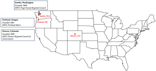
Figure 1.
Location of the three regions used as case studies (source: authors).

Table 1.
The three regions and their MPOs.
Table 2.
Socioeconomic highlights for three selected regions (source: Census Bureau Profiles, 2022).
3.2. Data Collection
To gain a deeper insight into the inner workings of each region, we interviewed individuals from regional planning organizations (MPOs), central cities, and transit operators in each region. We also conducted a thorough document review of regional-level policies, procedures, and processes to identify those geared toward the implementation of polycentric urban forms by promoting compact development and managing growth by directing new development toward predefined centers. All reviewed documents are listed in Appendix A, Appendix B, and Appendix C.
4. Case Studies
4.1. Portland, Oregon
Recognized for their progressive approach, the urban planning strategies employed in the Portland region of Oregon aim to combat urban expansion and encourage polycentric development. However, this has not consistently been the situation. Most of the region’s development in the 1970s occurred as a consequence of suburban encroachment, resulting in an increase in congestion concerns. In the beginning, transportation planners responded to the congestion by increasing road capacity in accordance with the prevalent philosophy of the time. However, things changed when the mayor of Portland supported the “freeway revolt” movement in the late 1970s. As a result, the governor of Oregon established a task force to examine alternatives to highway expansion, such as the implementation of light rail transit in the region. Then, 1000 Friends of Oregon commissioned the LUTRAQ study, which emphasized transit prioritization to facilitate polycentric development, alleviate congestion, and reduce vehicle miles traveled (VMT).
Portland Metro, the metropolitan planning organization (MPO), has played a crucial role in establishing Portland as a pioneering city in progressive planning. A state ballot proposal granted Portland Metro land use authority, thereby creating a regional government with more policymaking and decision-making power than MPOs in other regions of the United States. The implementation of the urban growth boundary (marked in red in Figure 2), which sought to limit urban growth and direct development inside already-existing urban zones, in 1977 was directly tied to this authority. The MPO, more precisely, Portland Metro, was given the responsibility of establishing, maintaining, and occasionally reevaluating the urban development boundary, which is still an essential Metro role.
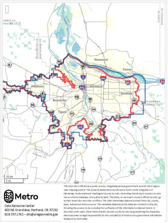
Figure 2.
Portland Metro area (marked in blue) (source: https://www.oregonmetro.gov (accessed on 10 January 2024)).
Using a combination of interviews and document analysis, this case study examines the policies, initiatives, tools, and strategies the Portland region put in place to encourage polycentric development. To gain firsthand knowledge of and perspectives on the initiatives put forth by these organizations to promote concentrated development, interviews with planners from Portland Metro (the metropolitan planning organization), the City of Portland, and TriMet (Portland’s transit agency) were conducted. Subsequently, materials received from the planners were carefully scrutinized in order to gain a fuller understanding of the region’s strategies for prioritizing development within centers.
4.1.1. Portland Metro
Portland Metro, Portland region’s metropolitan planning organization, is in many aspects unique among its peers nationwide. For one thing, it is the only directly elected regional government in the United States. In 1991, Portland Metro was granted land use powers (which, in other regions, rest solely in the hands of municipal or county governments) to provide regionwide planning and coordination to manage growth, infrastructure, and development issues that cross jurisdictional boundaries [49]. In fact, the agency has almost the same powers as a city—to tax, annex lands, and most importantly, control land use. Over the past three decades, its exceptional approach helped to build public transit (including the emblematic light rail and streetcar operations) instead of freeways, revitalize Portland’s downtown, resurrect neighborhoods, create urban villages, and implement urban growth boundaries [50]. Its commitment to compact development and land preservation coupled with unique regional oversight helped to establish mechanisms designed to steer new development toward polycentricity. Portland Metro uses command and control to direct new growth into compact development patterns.
Portland Metro serves three counties (Clackamas, Multnomah, Washington) and 24 cities and towns located in them—close to 2 million people in total (Table 2). Portland’s Urban Growth Boundary (UGB) almost perfectly overlaps with that of Portland Metro (Figure 2), the region’s MPO. Under Oregon law, each city and metropolitan area located within that state is required to have a UGB. Portland Metro is responsible for managing the Portland metropolitan area’s growth boundary.
4.1.2. The 2040 Growth Concept
The 2040 Growth Concept adopted by Portland Metro in 1995 is a state-mandated long-range plan whose main purpose is to manage growth and guide major future investments. Its main objective was to make the city and the region more livable by reducing pollution and congestion, and these are to be achieved through compact development. The map, which is an integral part of the plan (Concept), defines the form and boundaries of the future development for the Portland metropolitan region (Figure 3); it allocates land uses and provides development typologies for specific areas in the region (i.e., central city, regional centers, town centers, neighborhood centers, station communities). The Concept was initially developed through a visioning process where multiple scenarios for future development were considered. All scenarios assumed that the region’s population would grow from about 1.5 million in 1990 to over 2.7 million by 2040. With a heavy focus on maximizing spatial efficiency and concentrating on centers, this plan allocates more than 40 percent of the new residents into “town centers” and dense mixed-use neighborhoods. The 2040 Growth Concept strongly encourages redevelopment and “infill”; it calls for increasing the share of multi-family housing by five percent points (from 30 to 35).
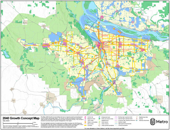
Figure 3.
The 2040 Growth Concept Map (source: https://www.oregonmetro.gov/2040-growth-concept (accessed on 10 January 2024)).
4.1.3. Urban Growth Management Functional Plan
The Urban Growth Management Functional Plan (UGMFP), a program run by Portland Metro, is intended to provide municipalities with guidelines and make it easier to coordinate policies in order to successfully achieve regional growth goals. The Plan makes recommendations for revising comprehensive plans and ordinances. The UGMFP exercises significant influence, in contrast to many other regional efforts around the United States. Since local governments are required to incorporate the suggested revisions into their comprehensive strategies, it follows that the mandates outlined in the UGMFP are not merely recommendations. If the UGMFP’s suggestions are not followed, a mediation and dispute resolution process may be started for the parties involved [51].
By influencing housing capacity, UGMFP uses a successful method to direct polycentric development. The Functional Plan establishes minimum housing densities for centers, in contrast to the common practice of employing maximum housing densities to impact urban development. Providing zoning ordinances’ minimum density is a rigid obligation, even when some conditions may permit a lower minimum. The Functional Plan also mandates that every zone that permits single-family housing must also permit at least one accessory dwelling unit per detached single-family dwelling unit in order to encourage more concentrated development in key zoning districts. In essence, this approach doubles the number of homes that low-density housing sites can accommodate.
The UGMFP imposes certain requirements on the use of regional funds and investments in centers. A county or municipality must clearly mark the boundaries of the center in order for it to qualify for regional investment. Additionally, it is essential for a municipality to conduct a thorough evaluation of each center, which should include an assessment of legal obstacles to mixed-use, pedestrian-oriented, and transit-supportive development, a market analysis, and an examination of how well the development code supports these types of development.
The proposed plan specifies the recommended population and employment densities for each center type. Moreover, the Functional Plan also suggests certain degrees and classifications of mixed-use development, as well as a variety of dwelling typologies, to be incorporated within centers.
4.1.4. Metro TOD Program
Portland Metro’s Transit-Oriented Development Program utilizes a variety of tools to promote and support the creation of high-density mixed-income housing near transit. Through the Program, Metro not only offers grants and enters partnerships with capable developers but also acquires land near transit for future affordable housing development. This approach encourages denser and more concentrated housing which promotes internal connectivity and encourages active modes of transportation. Portland region’s approach to promoting density and affordability within transit-oriented development is unique, innovative, and progressive, and places the region at the forefront of such efforts nationwide.
Metro TOD Program’s primary role is to provide incentives and support for projects near transit stations in an effort to promote more compact development. It offers funding and resources to projects that are near or adjacent to transit stations to enable higher density. The distribution of funds is based on the expected increase in transit use associated with the increased density. Since 1998, the program has invested over USD 40 million along greater Portland’s transit system, supporting the construction of over 6800 housing units in these areas [52].
4.1.5. State of the Centers Report
The Metropolitan government led the State of the Centers Report effort, which aims to undertake a quantitative review of the improvements made in the process of concentrating growth inside the centers situated around the region. The current study is an exhaustive work that compiles data and statistics and offers in-depth insights into the growth and development of designated centers throughout time. The main goal is to evaluate the development of the centers as outlined in the 2040 Growth Concept and to highlight any specific investments that have contributed to their success.
The report titled “State of the Centers” outlines six distinct typologies for centers and classifies specific centers in the region according to each of these six classifications. A single core urban center, eight subsidiary regional centers, and 32 smaller town centers are all clearly identified and given unique names in the study. Metro has acquired and examined information on the demographics, employment, mode share, housing, and commercial activity for each of the aforementioned centers from 2011 to 2017. The statistics for all 41 centers in the region are easily accessible through the interactive website, which was released in 2017.
4.1.6. 2040 Planning and Development Grants
Portland Metro also runs the 2040 Planning and Development Grants program with the aim of supporting development planning that adheres to the 2040 Growth Concept. The aforementioned program has given out awards totaling USD 22 million since it began in 2006. The grants are allocated for six different planning categories, including planning for urban reserves and new urban areas and investment strategies, as well as planning for site-specific development, area-specific redevelopment, and equitable housing initiatives and policies.
It is worth mentioning, as stated by a Metro planner who was interviewed, that the funds allocated by the 2040 Planning and Development Grants program are solely intended for planning activities within designated centers. By allocating money to enhancing these centers’ planning efforts, the initiative aims to increase their development potential.
4.2. Seattle, Washington
Although it may not be as well-known for its progressive planning as its neighbor to the south, Portland, Seattle, Washington, has a distinctive regional planning history. The Washington State Growth Management Act (GMA), which is comparable to Portland’s adoption of LUTRAQ, was put into effect by the state of Washington in 1990. This legislation’s goal was to make it easier for coordinated actions to be taken by various levels of government in order to control uncontrolled development. According to the GMA, counties must create comprehensive plans and regulations that adhere to the GMA’s mandated goals in order to meet specified size or growth thresholds. Municipalities located inside these counties must also develop comprehensive strategies that follow the county’s plans.
The Global Monitoring Approach (GMA) contains 14 distinct objectives in total, with a focus on the first 3 that are relevant to our field of interest. The aforementioned goals place a high priority on directing resources toward well-established urban centers, reducing the spread of low-density development, and promoting the establishment of efficient and sustainable transportation networks that accommodate a variety of modes of transportation. The GMA’s emphasis on several principles shows a dedication to polycentric development, which differs from the traditional and widespread development patterns that were popular at the time the law was passed.
A key component of the GMA is the creation of a framework for shared planning duties across multiple levels of government. The graphic depiction shown in Figure 4 represents a collaborative approach by the Washington State Planning Framework.

Figure 4.
Washington State Planning Framework.
We interviewed key stakeholders from the transit agency, the City of Seattle, and the Puget Sound Regional Council, which serves as the metropolitan planning organization, as part of our case study. We were able to identify numerous strategies that support polycentric development patterns in the Seattle region using a policy and legal document review and in-depth interviews with planners at the regional council, central city government, and transit agency. By using a holistic approach, we gained insightful knowledge of the many programs, funding sources, and policies that these organizations have put in place to support polycentric development.
4.2.1. Puget Sound Regional Council
The Puget Sound Regional Council is composed of nearly 100 members—not only four counties (King, Kitsap, Pierce, and Snohomish) and 73 cities and towns but also six transit agencies, four ports, four tribes, the Washington State Department of Transportation, and the Washington Transportation Commission, which collectively encompass 6290 square miles (Figure 5). The PSRC serves both as an MPO—a federally mandated and funded transportation policy-making organization—and an RTPO (Regional Transportation Planning Organization). In its capacity as an RTPO, PSRC oversees the implementation of the Growth Management Act through the certification of local comprehensive plans and the creation of multicounty planning policies, which are part of VISION 2050 (see below for more detail) [53].
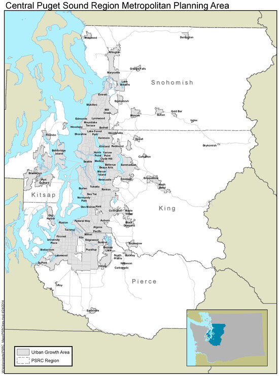
Figure 5.
Central Puget Sound Region Metropolitan Planning Area (source: https://www.psrc.org (accessed on 10 January 2024)).
4.2.2. Vision 2050
A regional planning document called Vision 2050 lays out a comprehensive growth strategy for the four counties with the greatest population in the state of Washington. The Washington Growth Management Act (GMA) mandates the location and mode of development within the region as well as provides guidance on related matters. The Puget Sound Regional Council (PSRC) used a variety of visioning tools, including conducting listening sessions, organizing focus groups, administering surveys, and analyzing data, to formulate a vision that considers both empirical needs and public preferences.
A projection of significant population and employment growth feeds the Vision 2050 assumptions. By 2050, there will be an estimated 1.8 million more people living in the region, according to the suggested strategy, and 1.2 million more jobs will also be available. In order to handle the growth, the Vision suggests a framework that concentrates 65% of the anticipated expansion inside designated growth centers and transit station areas. A number of specific policies—which will be further examined—help to support this goal. An easy quantitative assessment makes the idea of centers commonplace in the Vision: The 184-page document contains 205 references to the word “centers”.
4.2.3. Regional Centers Framework
The Puget Sound Regional Council (PSRC) has emphasized the importance of centers in its planning methodology, as evidenced by the prominence given to this concept in its Vision 2050 (2019) and Regional Centers Framework (2018) documents. The Regional Centers Framework’s introduction explicitly highlights the crucial function of centers in the regional planning carried out by the PSRC.
“Centers are the hallmark of VISION 2040 and the Regional Growth Strategy. They guide regional growth allocations, advance local planning, inform transit service planning, and represent priority areas for PSRC’s federal transportation funding.” [54]
An official from PSRC, whom we interviewed, revealed that at the time of the interview, the region consisted of 10 industrial centers and 29 regional growth centers. When selecting regional centers, the PSRC Executive Board performs a thorough evaluation to verify compliance and alignment with the regional vision. The centers’ selection was based on four different factors. The initial prerequisite is the demonstration of the proposed center’s local relevance, in which the sponsoring town or county demonstrates its commitment by contributing funds to the creation of a center that is livable and walkable. The execution of a center plan that complies with regional guidelines is the second criterion. The third requirement emphasizes the center’s physical location inside an urban region, while there may be particular circumstances in which exceptions to this rule are allowed. Last but not least, the assessment considers the existence of specific circumstances, such as the presence of sufficient infrastructure to enable the center’s expansion, including housing, employment, and density, or the likelihood that these circumstances will materialize in the near term.
The Regional Centers Framework provides a system of centers placed in hierarchical order, which is defined by objective and quantitative criteria, similar to other prominent regions with polycentric development patterns. Figure 6 shows the hierarchy and associated criteria adapted from the Regional Centers Framework.
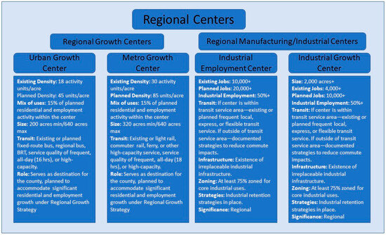
Figure 6.
Regional centers hierarchy and criteria (source https://www.psrc.org/our-work/centers (accessed on 10 January 2024)).
Urban growth centers and metro growth centers are the two categories into which regional growth centers are divided. In contrast to metropolitan growth centers, urban growth centers stand out for their larger physical size, higher activity density, and improved accessibility to transit. There are two subcategories included in the classification of regional industrial and manufacturing centers—industrial employment centers and industrial growth centers. Industrial growth centers stand out for their extensive spatial coverage, whereas industrial employment centers are characterized by a larger concentration of job opportunities. Figure 7 shows the location of all so far designated centers.
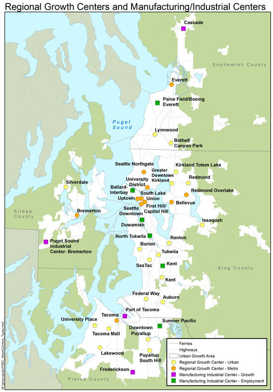
Figure 7.
Regional growth and industrial centers map (source: https://www.psrc.org/our-work/centers, accessed on 10 January 2024).
Though their designation is outside the authority of PSRC, the Regional Centers Framework includes two kinds of county-wide centers. Countywide centers are also divided into two groups—countywide growth centers and countywide industrial centers.
4.2.4. Funding Strategies
PSRC utilizes a variety of policies, including the Regional Centers Framework, Vision 2050, and the Regional Growth Strategy, to allocate grants as a catalyst for promoting polycentric development. According to one interviewee, the region prioritizes centers in its comprehensive plan and utilizes them as the basis for allocating funds. The process of allocating transportation funds from the MPO entails prioritizing projects, technical support, and infrastructure situated within specified regional growth centers.
“Funding is specifically prioritized to support designated regional growth centers, aligning with the regional vision. This includes transportation infrastructure funding as well as economic development funding. County-level and local funding sources are also encouraged to prioritize regional growth centers.” [54]
The Regional Centers Framework stipulates that, apart from providing direct funding to centers, the personnel of PSRC will aid in conducting research and identifying substitute funding sources to facilitate the growth of centers. Consistent with the practices of other MPOs, PSRC employs its Regional Transportation Plan (RTP) to allocate funding in a manner that is congruent with the polycentric outlook of PSRC.
4.2.5. Concurrency
Concurrency functions as a mechanism to guarantee that development occurs in areas where the requisite infrastructure is available to satisfy the transportation requirements linked with expansion. The Growth Management Act (GMA) acknowledges the use of concurrency as a means of directing growth toward suitable areas, particularly centers, in a deliberate manner.
“According to the GMA, concurrency involves establishing level-of-service standards for arterials, transit service, and other facilities. These standards are used to determine if a proposed development can be adequately served by existing facilities or if mitigation measures are necessary. The law requires cities and counties to have a strategy in place to reassess their services in case of deficiencies or shortfalls. This strategy allows jurisdictions to explore alternative funding sources, consider adjustments to the established level-of-service standards, or reevaluate land use assumptions.” [55]
It has been observed by researchers that the utilization of concurrency standards is a common practice to facilitate negotiations with developers, wherein they are required to provide certain concessions such as impact fees or infrastructure investments that may not have been mandatory otherwise. The policy has been formulated with the specific aim of directing expansion toward more compact areas, such as centers, that are capable of accommodating it in an efficient manner.
4.2.6. Regional Growth Strategy
The Vision 2050 initiative incorporates the Regional Growth Strategy as its crucial element, establishing a structure that promotes collaboration among various stakeholders responsible for supervising the area’s expansion and progress. The aim of the Strategy is as follows:
“To create healthy, equitable, vibrant communities well-served by infrastructure and services, the region accommodates growth in urban areas, primarily in designated centers and near transit stations.” [56]
The Regional Growth Strategy (RGS) consists of eight key components, which prioritize the concentration of regional growth in selected centers and are seen to be the most suitable areas for development. The suggested approach places a higher priority on maintaining a continuous urban growth zone and calls for hardly any perimeter extension unless absolutely necessary. Additionally, it encourages the adoption of intensive and focused development strategies inside the restricted areas. In order to provide a more fair distribution of housing and job opportunities across the region, the strategy’s primary objectives are to reduce regional travel and facilitate the development of specific communities. Furthermore, the aforementioned strategy clearly supports the idea of directing urban growth into particular city centers, encouraging even more concentration. The strategy aggressively promotes transit-oriented development and places a high value on the effective use of existing infrastructure.
4.2.7. Urban Growth Area
The Growth Management Act’s significant contribution was the creation of the Urban Growth Area (UGA). Similar to Portland’s Urban Growth Boundary, the UGA restricts the potential for suburban and exurban sprawl by limiting the amount of land available for such purposes. An interviewee emphasized the significance of this component in regional planning for PSRC. According to the official, the growth area contains a significant proportion of the region’s employment and population, with most of the expansion restricted to the UGA. The Vision 2050 plan outlines that the MPO and regional collaborators’ success will be measured by their capacity to accommodate growth until 2050 without the need to alter the current UGA boundary.
4.2.8. Transit-Oriented Development (TOD) Program
Vision 2050, the region’s long-range plan, allocates 65% of the future population growth and 75% of employment growth to regional growth centers and high-capacity transit station areas. Vision 2050 defines high-capacity transit station areas as areas within one-half of a mile of existing or planned light rail and streetcar stations, commuter rail stations, ferry terminals, and within one-fourth of a mile of all bus rapid transit stations (Figure 8). In 2013, the region adopted a Growing Transit Communities Strategy, an implementation plan to promote vibrant and equitable transit communities in the region, which led to the creation of the Growing Transit Communities Compact and the region’s equitable transit-oriented development strategy. In order to support individual communities in planning for such growth within transit corridors, PSRC developed a suite of guiding principles and requirements that are described in the following four documents: Implementing Equitable Transit Communities, Toolkit of Strategies and Actions, Transit-Supportive Planning Toolkit, and Whole Communities Toolkit. To oversee and track progress, PSRC established the Regional Transit-Oriented Development Committee and put in place a set of monitoring tools.
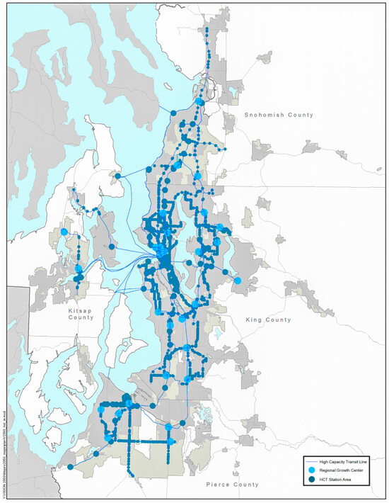
Figure 8.
Seattle region’s growth centers and high-capacity transit station areas (source: Vision 2050).
In fulfillment of the aspirations set forth for transit areas, Sound Transit, the region’s transit operator, adopted an Equitable Transit Oriented Development Policy. A Washington state statute requires that Sound Transit offer at least 80 percent of its surplus property that is suitable for housing to qualified entities to develop housing affordable to families at 80% of area median income or less.
4.3. Denver, Colorado
Over the course of more than four decades, the Denver metropolitan area has acquired significant expertise in the implementation of smart growth principles, with a particular emphasis on the advantages of mixed-use and high-density development alongside the Colorado Front Range. The Denver Regional Council of Governments (DRCOG), a non-profit organization composed of local governments, has been instrumental in advocating a unified and comprehensive vision for the region’s future. Although the DRCOG operates as a public agency, it does not possess the power to enforce membership criteria or guarantee that local governing bodies comply with its plans. Despite this, it performs a number of essential functions, including as the Regional Planning Commission mandated by Colorado law and as the metropolitan planning organization (MPO) for the Denver metropolitan area. Our analysis of polycentric development involved interviewing planners affiliated with the City and County of Denver, the Denver Regional Council of Governments (DRCOG—the MPO), and the Regional Transportation District (RTD—transit operator) as part of a case study. We made a specific request to the coordinators that they provide us with documents and resources pertinent to the expansion of Denver’s centers. The researchers then synthesized the primary findings from these interviews and incorporated them into a comprehensive examination of official plans and policies.
4.3.1. Denver Regional Council of Governments
The Front Range of Colorado experienced significant growth in the 1990s, accompanied by an expansion of land use and a decline in air quality. This circumstance prompted local communities to prioritize the issue of growth management. Despite the absence of statewide growth management legislative mandates in Colorado, the Denver Regional Council of Governments (DRCOG) has significantly influenced the discourse on smart growth by coordinating two influential growth management documents. Forty-six communities in the Denver region ratified an intergovernmental agreement known as the Mile High Compact in 2000. The aforementioned compact served to reaffirm the parties’ commitment to a unified regional perspective and required participating municipalities to implement comprehensive land use strategies using a variety of growth management tools, including zoning ordinances, development regulations, and urban growth boundaries.
Metro Vision 2020 was the initial regional plan to articulate this collective vision and employed a dual strategy to manage urban growth. The goal was to reduce the scale of urban expansion by instituting voluntary urban growth boundaries or zones while simultaneously promoting development within existing urban areas by establishing centers. The urban growth boundary/area (UGB/A) has had a substantial impact on the regional strategic plans for growth and development. The growth management strategy employs a grass-roots approach, beginning at the municipal level and placing a significant emphasis on cooperation between neighboring communities. Metropolitan areas, designated by local communities and acknowledged at the regional level by the Denver Regional Council of Governments (DRCOG) in its Metro Vision plan, are intended to provide ample space for a significant portion of future residential and occupational growth.
The Denver Regional Council of Governments is a nonprofit membership planning organization where 50 local governments located in nine counties collaborate to establish guidelines, set policy, and allocate funding in the areas of transportation and personal mobility as well as growth and development. DRCOG’s participating members are shown in Figure 9. DRCOG serves both as a metropolitan planning organization (MPO)—a federally mandated and funded transportation policy-making organization—and a Regional Planning Commission put in place by a Colorado state statute. In the latter capacity, DRCOG is responsible for preparing the plan for the physical development of the region (Metro Vision; see below for more details).
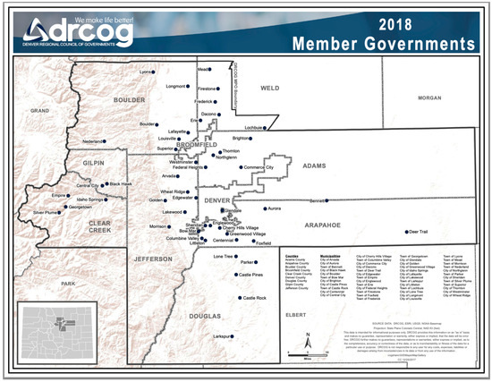
Figure 9.
DRCOG’s member governments (source: https://drcog.org, accessed on 10 January 2024).
4.3.2. Metro Vision and the Promotion of Urban Centers
The 1997-introduced Metro Vision plan has undergone several updates over the years. The most recent version, known as Metro Vision 2040, was unanimously approved by the DRCOG Board in 2017. The latest plan signifies a notable change in the regional strategy, shifting toward a thematic structure that prioritizes outcomes over previously rigid subject-based components. The proposed strategy is divided into five distinct thematic areas, each of which is associated with a distinct set of desirable outcomes and corresponding metrics for tracking progress. The topic of “An Efficient and Predictable Development Pattern” is highly relevant to the discussion at hand. The importance of centers in achieving the desirable development pattern cannot be overstated. One of this theme’s outcomes emphasizes the significance of planned and concentrated growth of new urban development in designated growth areas. Figure 10 depicts the geographic locations of these growth areas/centers in the vicinity of Denver.
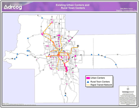
Figure 10.
Denver regions’ urban centers (source: 2040 Metro Vision Regional Transportation Plan).
The Metro Vision 2040 plan accommodates the region’s significant and continuous population growth. According to the plan, the population is expected to increase by 1,300,000 people between now and 2040, representing a growth rate of 40 percent and leading to a total population of approximately 4.3 million. In addition, according to the projection, the population of people aged 60 or older will surpass one million by 2040. By 2040, the plan anticipates a rise in employment from 1.8 million to 2.6 million. To facilitate the expansion, Metro Vision offers a comprehensive structure outlining the methods and locations of expansion, with the primary goal of directing a significant portion of the area’s growth toward centers. By the year 2040, the proposed plan calls for centers to contain a quarter of all housing and fifty percent of all employment. This is in stark contrast to the current statistics, which indicate that centers account for approximately 13% of housing and 35% of employment.
The Metro Vision 2040 plan recognizes the existence of 105 locally designated centers within the region, each with unique characteristics in terms of size, context, and geographic location. A significant number of these centers are located in strategic locations that align with existing or planned RTD rail routes. The development status of these centers varies, ranging from those that are still in the planning phase to those that are emerging and undergoing significant development activity and to those that are established and serve as mobility and activity centers for their respective communities. Eastlake, a meticulously designed urban center in Thornton, is currently undergoing development and will be facilitated by the rail line of North Metro, which began operations near the end of 2020. This can be seen at the 38th and Blake Station in Denver, which is a rapidly expanding metropolitan node alongside the RTD a line connecting downtown Denver to Denver International Airport. Southglenn, a well-established urban hub, occupies the site of a previous retail complex. It is centrally located in Centennial. The area has largely reached its maximum development potential, providing a pedestrian-friendly and metropolitan atmosphere, with the municipality making ongoing efforts to establish connections to less densely populated residential areas in neighboring communities.
In order to attain the intended results with regard to urban areas as delineated in Metro Vision, the plan proffers a range of strategic implementation measures that local jurisdictions may consider. These measures include:
- The approach of actively seeking out possibilities for collaborations between public and private entities to optimize resources and execute substantial undertakings in metropolitan areas.
- The adoption of policies and regulations that promote mixed-use development with higher density, facilitate pedestrian interaction, and establish publicly accessible spaces within urban areas.
4.3.3. Metro Vision Mobility Initiatives
The notion of creating a region that is well-connected and multimodal is a pivotal aspect of the Metro Vision 2040 framework. The RTD Fastracks initiative provides the foundation for the multimodal transportation infrastructure of the region and is instrumental in fostering the growth of both established and emerging urban areas. Since 2004, when Denver voters approved FasTracks, the Denver Regional Council of Governments (DRCOG) has actively promoted urban center planning and station-area planning. This is accomplished via the allocation of Transportation Improvement Program (TIP) funds, with a focus on the Station Area Master Plan/Urban Centers set-aside. This funding initiative has been implemented since the late 2000s to provide financial assistance for the planning of station areas and urban centers.
Local governments and regional partners can implement a variety of transportation system investment initiatives outlined in the Metro Vision 2040 plan. The Denver Regional Council of Governments (DRCOG) plays a pivotal role as a leader and funding partner in the execution of projects designed to expand regional mobility options and improve urban centers’ accessibility. The plan outlines numerous mobility initiatives, including:
- -
- The deployment of parking pricing and supply strategies, such as managed, shared, unbundled, and priced parking, within activity centers that have been designated at the local level. The aforementioned measures are designed to efficiently regulate the availability of parking spaces and promote the adoption of alternative modes of transportation, including but not limited to walking, cycling, ride-sharing, and public transit.
- -
- The provision of financial resources toward the creation of infrastructure for bicycles and pedestrians, as well as the establishment of links to public transportation, encompassing features such as walkways, designated lanes for bicycles, programs for bike-sharing, directional signage, parking facilities for bicycles, shelters, and services for car-sharing at transit stations.
- -
- The objective is to increase the variety of mobility alternatives accessible in urban areas and other designated activity centers, thereby augmenting transportation options for both inhabitants and tourists.
4.3.4. Initiatives Supporting Polycentric Development
DRCOG has implemented a range of programmatic, policy, and research endeavors to align with the objectives of Metro Vision. The primary aim of these initiatives is to foster a polycentric development pattern throughout the region. Through Metro Vision, local governments have agreed to direct a significant portion of growth and development to urban centers. Consequently, DRCOG strongly promotes the concept of connected urban centers throughout the region. In fact, out of the 50+ local governments that make up DRCOG, 26 have designated 105 urban centers across the region.
4.3.5. FasTracks Commitment in Principle
When FasTracks was approved in 2004, DRCOG initially committed to allocate USD 60 million from the Transportation Improvement Program (TIP) for its construction. DRCOG has consistently maintained its commitment in subsequent TIP processes. The allocation of funds by DRCOG is specifically earmarked for identified corridors that have been deemed worthy of investment. This is in line with the RTD FasTracks initiative, which seeks to establish seven novel rail corridors and extensions. The allocation of funds aims to mitigate regional transportation demands and facilitate the enlargement of the public transportation infrastructure. The program’s funded projects facilitate the attainment of Metro Vision objectives by jurisdictions, which in turn aid in the realization of a polycentric development pattern.
4.3.6. Transportation Improvement Program
Following the endorsement of FasTracks in 2004, DRCOG has consistently recognized and provided financial backing to initiatives that promote the progression of centers. During various cycles of the Transportation Improvement Program (TIP), the scoring criteria incorporated a component that offered incentives for projects that were consistent with the implementation of Metro Vision and a strategic corridor focus. During the 2016–2021 cycle, supplementary points were granted to initiatives linked with Urban Centers and Rapid Transit Stations. During the 2020–2023 cycle, a regional/sub-regional TIP was implemented to evaluate projects competing for regional funding. The assessment criteria for these projects included their alignment and contribution toward the transportation-oriented objectives of Metro Vision.
4.3.7. Transportation Improvement Program Station Area and Urban Center Plan Funding
For a number of station area and urban center plans, specific money was allotted via the Transportation Improvement Program (TIP) set-aside for Station Area Master Plan/Urban Centers (STAMP/UC). The objective of this funding is to foster the advancement of the financially restricted rapid transit system, at both present and potential rapid transit station sites, while concurrently enabling the growth of urban centers recognized as part of the Metro Vision plan.
4.3.8. Regional Scenario Analysis
The Denver Regional Council of Governments (DRCOG) has been involved in assessments to evaluate the regional benefits of a growth strategy centered around urban centers since the implementation of the Metro Vision 2020 plan. The advantages of developments with a polycentric pattern connected by a thorough multi-modal transportation infrastructure have constantly been underlined by DRCOG by examining several growth scenarios that prioritize alternative ways to steer development within the Denver region. The latest scenario analysis carried out for the regional transportation plan of 2050 reiterates the aforementioned discoveries. The scenario labeled “Centers + Transit” exhibits superior performance compared with other scenarios, as evidenced by a noteworthy reduction of 24 percent in vehicle miles traveled, a threefold surge in walking and cycling trips, and a sixfold surge in transit trips.
4.3.9. Transit-Oriented Development Strategy (TOD)
Although DRCOG does not have a regional transit-oriented development strategy or vision, both the city and the county of Denver and the Regional Transportation District (RTD), the region’s transit agency that serves seven of the nine member counties of DRCOG, do have them. Denver’s Transit-Oriented Development Strategic Plan, “Transit Oriented Denver”, provides guidance for public and private investment near rail stations. It contains both city-wide recommendations and action items intended for station areas. In addition, in 2021, the RTD Board approved the Equitable Transit-Oriented Development Policy, which encourages the development of affordable housing on RTD property near high-frequency transit stations. The ETOD policy allows for a partial or complete replacement of existing park-and-ride lots, shared parking, and a reduction in land price in exchange for affordable housing.
5. Discussion
To gain a deeper insight into the inner workings of each region, we interviewed individuals from regional planning organizations (MPOs), central cities, and transit operators in each region. We also conducted a thorough document review of regional-level policies, procedures, and processes to identify those geared toward the implementation of polycentric urban forms.
The case of Portland exemplifies a region distinguished by its advanced implementation of polycentric development strategies. Different entities, such as the metropolitan planning organization (MPO), the city, and the transit authority, are tasked with promoting polycentric development and advancing a broader regional vision. Notable about this region is the expansive land use authority granted to Portland Metro, thereby endowing the MPO with greater influence compared with other MPOs that are primarily concerned with transportation planning and expenditure. The expanded jurisdiction enables the formulation of regional strategies to curtail urban sprawl and promote concentrated growth, which are then implemented across multiple venues, including municipal, community, and transportation sectors. Interviews with multiple agencies, including the City of Portland and TriMet, disclosed the implementation of innovative policies intended to guide the development of centers. This paper provides empirical evidence validating the achievement of the Portland region’s polycentric development pattern. This outcome was expected due to the comprehensive policy initiatives that have been outlined.
Portland is a notable example of effective collaborative regional governance in which land use and transportation planning are coordinated. The findings from the informant interviews indicate that each agency has an acute awareness of how their respective initiatives contribute to the larger regional context and are in harmony with the initiatives of other agencies. MPO officials articulate the elevated regional perspective with aplomb, elucidating the distinct policy structures that supervise regional planning and the execution of collective objectives, such as polycentric development. TriMet and the City of Portland have significant roles in this process even to the point that the city has a center-based land use map that looks very similar to the MPOs’, though on a smaller scale.
In the Seattle metropolitan area, multiple levels of government collaborate as an example of integrated regional planning to achieve a common goal of polycentric development. The Seattle Metropolitan Planning Organization (PSRC) possesses more authority than standard MPOs, akin to Portland. This elevated status enables the PSRC to promote a regional development agenda through policies such as the Regional Centers Framework, the Growth Boundary, and the Regional Growth Strategy. PSRC has the authority to implement these policies by endorsing or mandating modifications to comprehensive plans, in contrast to the discretionary nature of guidance from many MPOs. This measure ensures that the municipalities within the region adhere to the regional goals, which include the promotion of concentrated development.
Moreover, Sound Transit and the City of Seattle aim to establish a polycentric region. The municipality has implemented several policies with a particular emphasis on centralized development, such as a tiered system of centers that concentrates growth in suitable zones. The municipality has developed its own Growth Strategy, which conforms to the regional approach while considering the city’s unique circumstances. Expansion of vital transportation infrastructure is essential to directing growth in the Seattle region. Being a regional transit authority, Sound Transit is responsible for facilitating polycentric development through infrastructure development. As the region prepares for the United States’ largest public transit expansion, Sound Transit is working closely with other regional stakeholders, including the City and the MPO, to ensure that capital investments align with the goals of centered and responsible development.
The case study of the Denver region demonstrates the effective coordination of regional planning across multiple government levels in order to achieve a shared vision of urban centers and a polycentric development model. Diverse regional and local policies and instruments are employed to facilitate the development of new centers and the expansion of existing centers, particularly those located along the expanding regional rail transportation system administered by the RTD.
In contrast to Portland and Seattle, DRCOG relies on the voluntary cooperation of its constituent jurisdictions to implement its growth management strategy. By aggregating resources, the MPO, transit authority, and local governments have demonstrated the utmost level of effectiveness in planning and constructing interconnected urban centers. RTD’s investments in the regional transit system and DRCOG’s funding for station development are indispensable contributors to the collaborative effort.
As shown in Table 3, all three regions have in place the tools necessary for a successful implementation of the polycentric urban form—a clearly communicated vision and goals, a set of tools that provide guidance on how to achieve them—and measures to track and assess progress. Each of the long-range plans emphasizes the importance of managing growth and proactively directing new development into specifically designated centers throughout each region. While in the case of both Portland and Seattle, the MPOs have enough power to impose such goals on their regions, in Denver, local governments have collectively decided to direct a significant portion of growth and development to urban centers. To support and guide the implementation, all three regions have developed a strong suite of policies focused on managing growth and developing local centers, including thriving transit station areas. They also provided targeted funding to stimulate the growth of regional centers and transit station areas. Finally, they introduced tracking tools that allow for effective monitoring of progress.
Table 3.
Policy tools used by each region.
Clear goals, a shared vision, implementation toolkits, and trackable performance measures are crucial for success. However, none would be possible without strong regional governance, either in the form of authority or cooperation. In the case of Portland, Seattle, and Denver (to a lesser extent), such governance exists.
6. Conclusions
Today, cities and regions across the United States are all facing very similar challenges. Brought about by a century-long rapid growth and unrestricted urban sprawl, the problems of air pollution, traffic congestion, inequity, and urban poverty have reached a gargantuan magnitude. To quote Anthony Downs, “urban sprawl has contributed to unexpected growth-related dilemmas that threaten the long-run viability of American society” [57] (p. 3). More importantly, these pressing issues are poorly addressed by ill-equipped and fragmented local governments. These dire circumstances have given a new impetus to the idea of strong regional governance, which first rose and quickly declined in the 1960s and 1970s swiftly defeated by localism [46]. In today’s reality, key urban planning decisions are often made at the regional level. Equally, the impacts of such decisions are also felt at the regional level. Although “we have become a nation of metropolitan regions, we have not developed consensus for the formation of metropolitan governments at the regional level” [46] (p. 509). Even though polycentric development offers realistic solutions to many of the daunting problems faced by fast-expanding urbanized areas, the regional governance necessary to implement it is mostly lacking.
The Portland, Seattle, and Denver regions are among the most successful regions in the country in terms of their successful implementation of growth management strategies and containing sprawl. All three have successfully put in place planning and procedural mechanisms promoting compact polycentric development. This success, however, would not have been possible without strong regional governance practiced by each of the three regions. While Portland Metro enjoys regime-like absolute powers [48], Seattle relies on highly collaborative and integrated regional planning, with the MPO playing a lead role as it possesses more authority than standard MPOs in the country. Denver, on the other hand, has managed to develop effective coordination of regional planning across multiple government levels based on a shared vision. In each instance, regional planning takes precedence over local preferences and ambitions. Similarly, each case demonstrates a different level of regional control.
It is indisputable that regional-level intervention is necessary for the successful combating of the problems currently haunting urbanized areas across the country. Such intervention clearly requires strong regional governance which, as shown by the three case studies presented in this research, may take very different forms ranging from total control (Portland) to purely voluntary cooperation (Denver). Each of the approaches exemplified by the three case studies emerged organically from the specific underlying political and social context of each place, but also each was deeply rooted in a conviction that a successful regional governance matters and in fact makes all the difference. Equally, each of the three approaches has its benefits and shortcomings.
This study provides examples that offer guidance and inspiration to planners across the country. It does not offer a prescriptive solution as there are many paths to success, but all of them rely heavily on effective regional governance.
Author Contributions
Conceptualization, R.E.; methodology, R.E.; investigation, T.L., S.H.A. and J.H.; writing—original draft, R.E., T.L., S.H.A. and J.H.; writing—review and editing, R.E. and J.K.; supervision, T.L.; project administration, R.E.; funding acquisition, R.E. All authors have read and agreed to the published version of the manuscript.
Funding
This research was funded by the NSF, the National Institute for Transportation and Communities (NITC), and the U.S. DOT University Transportation Center.
Institutional Review Board Statement
Not applicable.
Informed Consent Statement
Not applicable.
Data Availability Statement
Data is contained within the article.
Conflicts of Interest
The authors declare no conflicts of interest.
Appendix A. Documents Reviewed for the Portland Case Study
City of Portland (2011). Comprehensive Plan Goals and Policies. Retrieved from https://www.portlandonline.com/bps/Comp_Plan_Nov2011.pdf (accessed on 10 January 2024).
City of Portland (2013). Portland Zoning. Retrieved from https://www.portlandmaps.com/bps/zoning/#/about/ (accessed on 10 January 2024).
City of Portland (2020). Zoning Code. Retrieved from https://www.portlandoregon.gov/bps/31612 (accessed on 10 January 2024).
Oregon Metro (2014). 2040 Growth Concept Map. Retrieved from https://www.oregonmetro.gov/sites/default/files/2016/10/18/2040GrowthConcept.pdf (accessed on 10 January 2024).
Oregon Metro (2010). Urban Growth Management Functional Plan. Retrieved from https://www.oregonmetro.gov/sites/default/files/2018/04/16/urban-growth-management-functional-plan-04162018.pdf (accessed on 10 January 2024).
Oregon Metro (2019). Transit-Oriented Development Investment Criteria. Retrieved from https://www.oregonmetro.gov/sites/default/files/2019/02/05/Revised-Investment-Criteria-2-5-19.pdf (accessed on 10 January 2024).
Oregon Metro (2011). State of the Centers Investing in Our Communities. Retrieved from https://www.oregonmetro.gov/sites/default/files/2015/02/25/2011_state_of_the_centers_0.pdf (accessed on 10 January 2024).
TriMet (2015). The Future of Transit Southwest Service Enhancement Plan Final Report. Retrieved from https://trimet.org/future/pdf/southwest-final-report.pdf (accessed on 10 January 2024).
Appendix B. Documents Reviewed for the Seattle Case Study
Puget Sound Regional Council (2019). Draft Vision 2050 Plan. Retrieved from https://www.psrc.org/sites/default/files/draft-vision2050-plan.pdf (accessed on 10 January 2024).
Puget Sound Regional Council. Part II: Regional Growth Strategy. Retrieved from https://www.psrc.org/sites/default/files/part_ii_regional_growth_strategy.pdf (accessed on 10 January 2024).
Puget Sound Regional Council (2018). Regional Centers Framework Update. Retrieved from https://www.psrc.org/sites/default/files/final_regional_centers_framework_march_22_ver (accessed on 10 January 2024).
Laschever, E. S. (1998). An Overview of Washington’s Growth Management Act. Pacific Rim Law & Policy Journal, 7, 657.
The City of Seattle (2016). Seattle 2035 Comprehensive Plan. Retrieved from comprehensivePlan/CouncilAdopted2019.pdf (accessed on 10 January 2024).
Sound Transit (2016). Sound Transit 3 The Regional Transit System Plan for Central
Puget Sound. Retrieved from https://st32.blob.core.windows.net/media/Default/Document%20Library%20Featured/8-2 (accessed on 10 January 2024).
Appendix C. Documents Reviewed for the Denver Case Study
Blueprint Denver (2019). Retrieved from https://www.denvergov.org/media/denvergov/cpd/blueprintdenver/Blueprint_Denver.pdf (accessed on 10 January 2024).
Comprehensive Plan 2040: Denver’s Plan for the Future (2019). Retrieved from https://www.denvergov.org/content/dam/denvergov/Portals/Denveright/documents/comp-plan/Denver_Comprehensive_Plan_2040_city_council_draft.pdf (accessed on 10 January 2024).
Denver Transit-Oriented Development Strategic Plan. (2014) Retrieved from https://www.denvergov.org/content/dam/denvergov/Portals/193/documents/TOD_Plan/TOD_Strategic_Plan_FINAL.pdf (accessed on 10 January 2024).
Denver Zoning Code (2010). Retrieved from https://www.denvergov.org/content/dam/denvergov/Portals/646/documents/Zoning/DZC/Complete_Denver_Zoning_Code.pdf (accessed on 10 January 2024).
DRCOG 2012–2017 Transportation Improvement Program. Retrieved from http://www3.drcog.org/documents/archive/Amended%202012-2017%20TIP%20Policy%20-%20Amended%20May%202013.pdf (accessed on 10 January 2024).
DRCOG 2020-2023 Transportation Improvement Program. Retreived from https://drcog.org/sites/default/files/resources/Adopted%202020-2023%20TIP%20Policy.pdf (accessed on 10 January 2024).
DRCOG 2040 Metro Vision Regional Transportation Plan (2017). Retrieved from https://drcog.org/sites/drcog/files/resources/FINAL%20-%202040%20MVRTP%20-%20April%202017.pdf (accessed on 10 January 2024).
DRCOG 2050 Metro Vision Regional Transportation Plan Draft 2050 Scenario Outcome Results (2020). Retrieved from https://drcog.org/sites/default/files/event-materials/REVISED%20Attachment%20D%20Presentation%20-Scenario%20results%20for%20March%2023%2C%202020%20TAC.pdf (accessed on 10 January 2024).
DRCOG Community Mobility Planning and Implementation (2019). Set-Aside FY 2020 and FY 2021 Projects Eligibility Rules and Selection Process. Retrieved from https://drcog.org/sites/default/files/CMPI_Eligibility_Rules_and_Selection_Process_Final.pdf (accessed on 10 January 2024).
DRCOG Metro Vision 2020 (1995). Vision Framework for the Denver Metropolitan Region. Retrieved from https://drcog.org/sites/drcog/files/resources/1995%20MV%20Framework%201b.pdf (accessed on 10 January 2024).
DRCOG Metro Vision 2040 (2017) https://indd.adobe.com/view/8bb0b608-d82e-44da-8303-e379416c7e5a (accessed on 10 January 2024).
DRCOG Metro Vision Idea Exchange. Retrieved from https://metrovision.drcog.org/in_practice/idea_exchanges/ (accessed on 10 January 2024).
DRCOG Perspective on Transit in the Denver Region (2016). Retrieved from https://drcog.org/sites/default/files/resources/RPD-RP-WHOTOD-18-10-31-V15.pdf (accessed on 10 January 2024).
RTD FasTracks Commitment in Principle http://www3.drcog.org/documents/archive/DRCOG%20FasTracks%20Review%20and%20Determination%20Report%20-%20April%2023.pdf (accessed on 10 January 2024).
RTD FasTracks Strategic Plan for TOD (2010). Retrieved from https://www.rtd-denver.com/sites/default/files/files/2019-08/rtd-tod-fastracks-strategic-plan-2010.pdf (accessed on 10 January 2024).
RTD First and Last Mile Strategic Plan (2019). Retrieved from https://www.rtd-denver.com/sites/default/files/files/2019-07/FLM-Strategic-Plan_06-10-19.pdf (accessed on 10 January 2024).
RTD Regional BRT Network Feasibility Study (2019). Retrieved from https://www.rtd-denver.com/sites/default/files/files/2020-03/RTD-regional-BRT-feasibility-study.pdf (accessed on 10 January 2024).
RTD TOD Evaluation Guidelines (2018). Retrieved from https://www.rtd-denver.com/sites/default/files/files/2018-08/tod-evaluation-guidelines-2018.pdf (accessed on 10 January 2024).
RTD TOD Status Report (2019). https://www.rtd-denver.com/sites/default/files/files/2020-05/2019-TOD-status-report.pdf (accessed on 10 January 2024).
RTD Transit-Oriented Development Design Criteria (2012). RTD FasTracks. Retrieved from https://www.rtd-denver.com/sites/default/files/files/2018-08/tod-design-criteria-rtd-final.pdf (accessed on 10 January 2024).
References
- Park, K.; Ewing, R.; Sabouri, S.; Choi, D.; Hamidi, S.; Tian, G. Guidelines for a polycentric region to reduce vehicle use and increase walking and transit use. J. Am. Plan. Assoc. 2020, 86, 236–249. [Google Scholar] [CrossRef]
- Anderson, W.P.; Kanaroglou, P.S.; Miller, E.J. Urban form, energy and the environment: A review of issues, evidence and policy. Urban Stud. 1996, 33, 7–35. [Google Scholar] [CrossRef]
- Ewing, R. Is Los Angeles-style sprawl desirable? J. Am. Plan. Assoc. 1997, 63, 107–126. [Google Scholar] [CrossRef]
- Ewing, R.; Cervero, R. Travel and the built environment: A meta-analysis. J. Am. Plan. Assoc. 2010, 76, 265–294. [Google Scholar] [CrossRef]
- Florida, R. The creative class and economic development. Econ. Dev. Q. 2014, 28, 196–205. [Google Scholar] [CrossRef]
- Graham, S.; Marvin, S. Telecommunications and the City: Electronic Spaces, Urban Places; Routledge: New York, NY, USA, 2002. [Google Scholar]
- Jacobs, J. The Death and Life of Great American Cities; 5. pr.; JSTOR: New York, NY, USA, 1961. [Google Scholar]
- Nelson, A.C.; Dawkins, C.J. The Social Impacts of Urban Containment; Routledge: New York, NY, USA, 2016. [Google Scholar]
- Thomas, L.; Cousins, W. The Compact City: A Successful, Desirable and Achievable Urban Form; Routledge: New York, NY, USA, 1996; pp. 53–65. [Google Scholar]
- Ewing, R.; Hamidi, S. Costs of Sprawl; Routledge: New York, NY, USA, 2017. [Google Scholar]
- Breheny, M. The compact city: An introduction. Built Environ. 1992, 18, 241. [Google Scholar]
- Gordon, P.; Richardson, H.W. Are compact cities a desirable planning goal? J. Am. Plan. Assoc. 1997, 63, 95–106. [Google Scholar] [CrossRef]
- Green, R. Not compact cities but sustainable regions. In The Compact City: A Sustainable Urban Form; Routledge: New York, NY, USA, 1996; pp. 56–78. [Google Scholar]
- Holcombe, R.G.; Williams, D.W. Urban sprawl and transportation externalities. Rev. Reg. Stud. 2010, 40, 257–273. [Google Scholar] [CrossRef]
- Kahn, M.E. Sprawl: A Compact History. By Robert Bruegmann. Chicago: University of Chicago Press, 2005. Pp. 301. $27.50. J. Econ. Hist. 2006, 66, 252–253. [Google Scholar] [CrossRef]
- Knight, C. Economic and social issues. In The Compact City: A Sustainable Urban Form; Routledge: New York, NY, USA, 1996; pp. 114–121. [Google Scholar]
- Davoudi, S. Polycentricity in European spatial planning: From an analytical tool to a normative agenda. Eur. Plan. Stud. 2003, 11, 979–999. [Google Scholar] [CrossRef]
- Garreau, J. Edge City: Life on the New Frontier; Anchor: New York, NY, USA, 2011. [Google Scholar]
- Yang, J.; French, S.; Holt, J.; Zhang, X. Measuring the structure of US metropolitan areas, 1970–2000: Spatial statistical metrics and an application to commuting behavior. J. Am. Plan. Assoc. 2012, 78, 197–209. [Google Scholar] [CrossRef]
- Hajrasouliha, A.H.; Hamidi, S. The typology of the American metropolis: Monocentricity, polycentricity, or generalized dispersion? Urban Geogr. 2017, 38, 420–444. [Google Scholar] [CrossRef]
- Medeiros, E. (Ed.) Debating the urban dimension of territorial cohesion. In Territorial Cohesion: The Urban Dimension; Springer International Publishing: Berlin/Heidelberg, Germany, 2019; pp. 3–22. [Google Scholar] [CrossRef]
- Meeteren, M.V.; Poorthuis, A.; Derudder, B.; Witlox, F. Pacifying Babel’s Tower: A scientometric analysis of polycentricity in urban research. Urban Stud. 2016, 53, 1278–1298. [Google Scholar] [CrossRef]
- Burger, M.J.; Van Der Knaap, B.; Wall, R.S. Polycentricity and the multiplexity of urban networks. Eur. Plan. Stud. 2014, 22, 816–840. [Google Scholar] [CrossRef]
- Sabouri, S. Assessing polycentric development in terms of trip chaining efficiency. Cities 2021, 117, 103300. [Google Scholar] [CrossRef]
- Vasanen, A. Functional polycentricity: Examining metropolitan spatial structure through the connectivity of urban sub-centres. Urban Stud. 2012, 49, 3627–3644. [Google Scholar] [CrossRef]
- Abozeid, A.S.M.; AboElatta, T.A. Polycentric vs monocentric urban structure contribution to national development. J. Eng. Appl. Sci. 2021, 68, 1–18. [Google Scholar] [CrossRef]
- Ewing, R.; Pendall, R.; Chen, D. Measuring Sprawl and Its Impact; Smart Growth America: Washington, DC, USA, 2002. [Google Scholar]
- Ewing, R.; Hamidi, S. Measuring Urban Sprawl and Validating Sprawl Measures; National Institutes of Health and Smart Growth America: Washington, DC, USA, 2014. [Google Scholar]
- Ewing, R.; Hamidi, S. Compactness versus sprawl: A review of recent evidence from the United States. J. Plan. Lit. 2015, 30, 413–432. [Google Scholar] [CrossRef]
- Naess, P. Urban form and travel behavior: Experience from a Nordic context. J. Transp. Land Use 2012, 5, 21–45. [Google Scholar] [CrossRef]
- Zegras, C. The built environment and motor vehicle ownership and use: Evidence from Santiago de Chile. Urban Stud. 2010, 47, 1793–1817. [Google Scholar] [CrossRef]
- Næss, P.; Strand, A.; Wolday, F.; Stefansdottir, H. Residential location, commuting and non-work travel in two urban areas of different size and with different center structures. Prog. Plan. 2019, 128, 1–36. [Google Scholar] [CrossRef]
- Mogridge, M.J.H. Transport, land use and energy interaction. Urban Stud. 1985, 22, 481–492. [Google Scholar] [CrossRef]
- Hu, L.; Sun, T.; Wang, L. Evolving urban spatial structure and commuting patterns: A case study of Beijing, China. Transp. Res. Part D Transp. Environ. 2018, 59, 11–22. [Google Scholar] [CrossRef]
- Schwanen, T.; Dieleman, F.M.; Dijst, M. Car use in Netherlands daily urban systems: Does polycentrism result in lower commute times? Urban Geogr. 2003, 24, 410–430. [Google Scholar] [CrossRef]
- Zhao, J.; Qu, Q.; Zhang, F.; Xu, C.; Liu, S. Spatio-temporal analysis of passenger travel patterns in massive smart card data. IEEE Trans. Intell. Transp. Syst. 2017, 18, 3135–3146. [Google Scholar] [CrossRef]
- Modarres, A. Polycentricity, commuting pattern, urban form: The case of Southern California. Int. J. Urban Reg. Res. 2011, 35, 1193–1211. [Google Scholar] [CrossRef]
- Sun, B.; He, Z.; Zhang, T.; Wang, R. Urban spatial structure and commute duration: An empirical study of China. Int. J. Sustain. Transp. 2016, 10, 638–644. [Google Scholar] [CrossRef]
- Schwanen, T.; Dieleman, F.M.; Dijst, M. The impact of metropolitan structure on commute behavior in the Netherlands: A multilevel approach. Growth Chang. 2004, 35, 304–333. [Google Scholar] [CrossRef]
- Yang, L.; Wang, Y.; Bai, Q.; Han, S. Urban form and travel patterns by commuters: Comparative case study of Wuhan and Xi’an, China. J. Urban Plan. Dev. 2018, 144, 05017014. [Google Scholar] [CrossRef]
- Ewing, R.; Park, K.; Sabouri, S.; Lyons, T.; Kim, K.; Choi, D.; Daly, K.; Etminani Ghasrodashti, R.; Kiani, F.; Ameli, H.; et al. Reducing Vehicle Miles Traveled (VMT), Encouraging Walk Trips, and Facilitating Efficient Trip Chains through Polycentric Development; NITC-RR-1217; Transportation Research and Education Center (TREC): Portland, OR, USA, 2020. [Google Scholar]
- Cervero, R.; Wu, K.-L. Sub-centering and commuting: Evidence from the San Francisco Bay Area, 1980–1990. Urban Stud. 1998, 35, 1059–1076. [Google Scholar] [CrossRef]
- Daisy, N.S.; Millward, H.; Liu, L. Trip chaining and tour mode choice of non-workers grouped by daily activity patterns. J. Transp. Geogr. 2018, 69, 150–162. [Google Scholar] [CrossRef]
- Pressman, J.L.; Wildavsky, A. Implementation: How Great Expectations in Washington Are Dashed in Oakland; Or, Why It's Amazing that Federal Programs Work at All, This Being a Saga of the Economic Development Administration as Told by Two Sympathetic Observers Who Seek to Build Morals on a Foundation; University of California Press: Oakland, CA, USA, 1984; Volume 708. [Google Scholar]
- Ewing, R.; Lyons, T.; Siddiq, F.; Sabouri, S.; Kiani, F.; Hamidi, S.; Ameli, H. Growth management effectiveness: A literature review. J. Plan. Lit. 2022, 37, 433–451. [Google Scholar] [CrossRef]
- Griffith, J.C. Regional Governance Reconsidered. J. Law Politics 2005, 21, 505. [Google Scholar]
- Jonas, A.E.; Pincetl, S. Rescaling regions in the state: The new regionalism in California. Political Geogr. 2006, 25, 482–505. [Google Scholar] [CrossRef]
- Leo, C. Regional growth management regime: The case of Portland, Oregon. J. Urban Aff. 1998, 20, 363–394. [Google Scholar] [CrossRef]
- What Is Metro? Retrieved from Oregon Metro: 2023. Available online: https://www.oregonmetro.gov/regional-leadership/what-metro (accessed on 7 December 2023).
- Hovey, B. Making the Portland way of planning: The structural power of language. J. Plan. Hist. 2003, 2, 140–174. [Google Scholar] [CrossRef]
- Urban Growth Management Functional Plan. Retrieved from Oregon Metro: 2023. Available online: https://www.oregonmetro.gov/urban-growth-management-functional-plan (accessed on 7 December 2023).
- Transit-Oriented Development Program. Retrieved from Oregon Metro: 2023. Available online: https://www.oregonmetro.gov/tools-partners/grants-and-resources/transit-oriented-development-program (accessed on 7 December 2023).
- Puget Sound Regional Council. Retrieved from Puget Sound Regional Council: 2023. Available online: https://www.psrc.org (accessed on 9 December 2023).
- Centers. Retrieved from Puget Sound Regional Council: 2023. Available online: https://www.psrc.org/our-work/centers (accessed on 9 December 2023).
- Concurrency. Retrieved from Empowering Local Government: 2023. Available online: https://mrsc.org/explore-topics/planning/general-planning-and-growth-management/concurrency (accessed on 9 December 2023).
- Regional Growth Strategy. Retrieved from Regional Growth Strategy: 2023. Available online: https://www.psrc.org/sites/default/files/2022-02/vision-2050-mpp-rgs.pdf (accessed on 9 December 2023).
- Downs, A. New Visions for Metropolitan America; Brookings Institution: Washington, DC, USA, 1994. [Google Scholar]
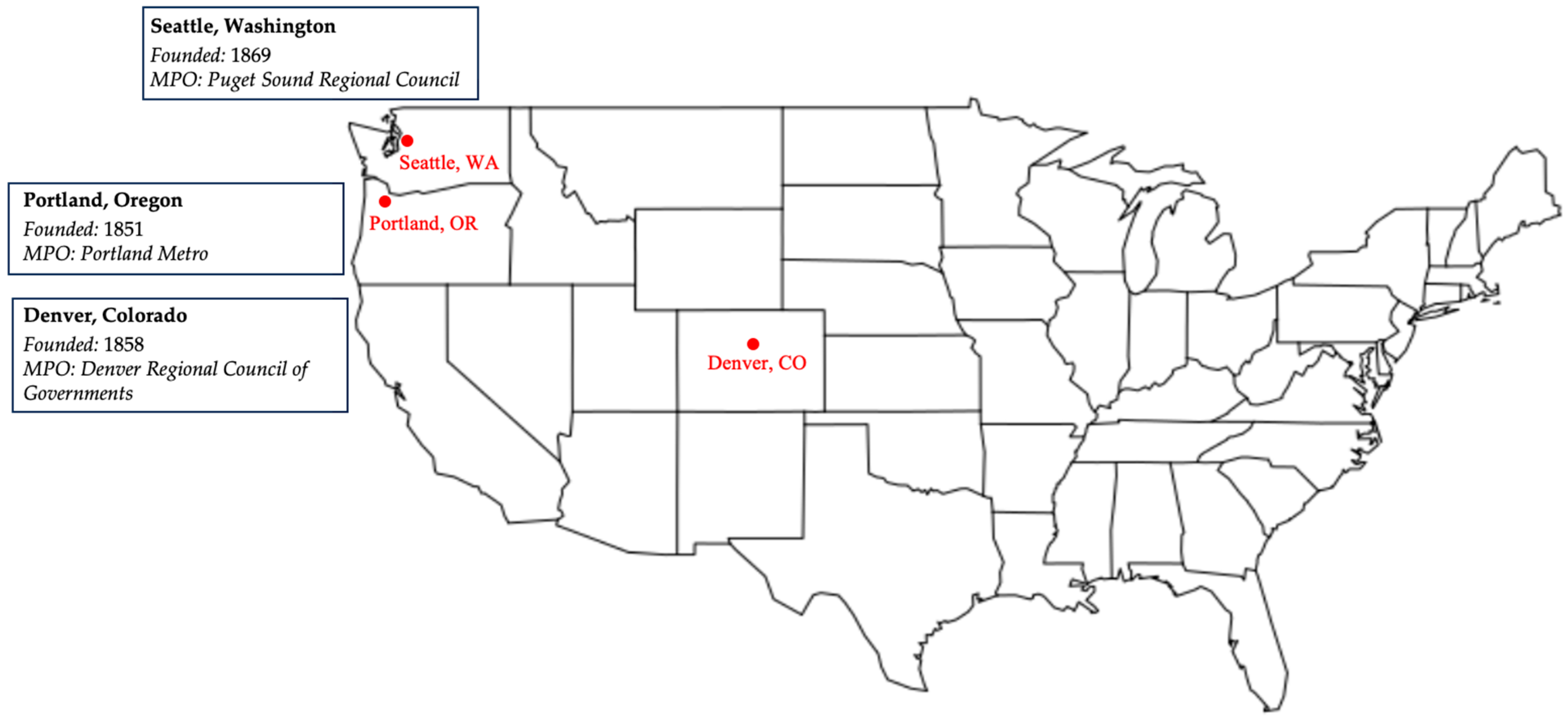

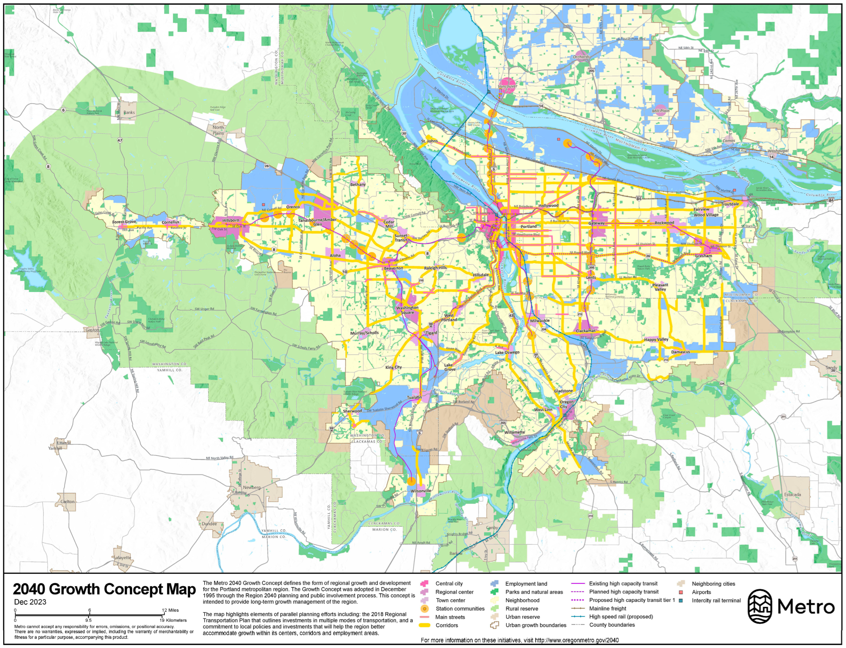
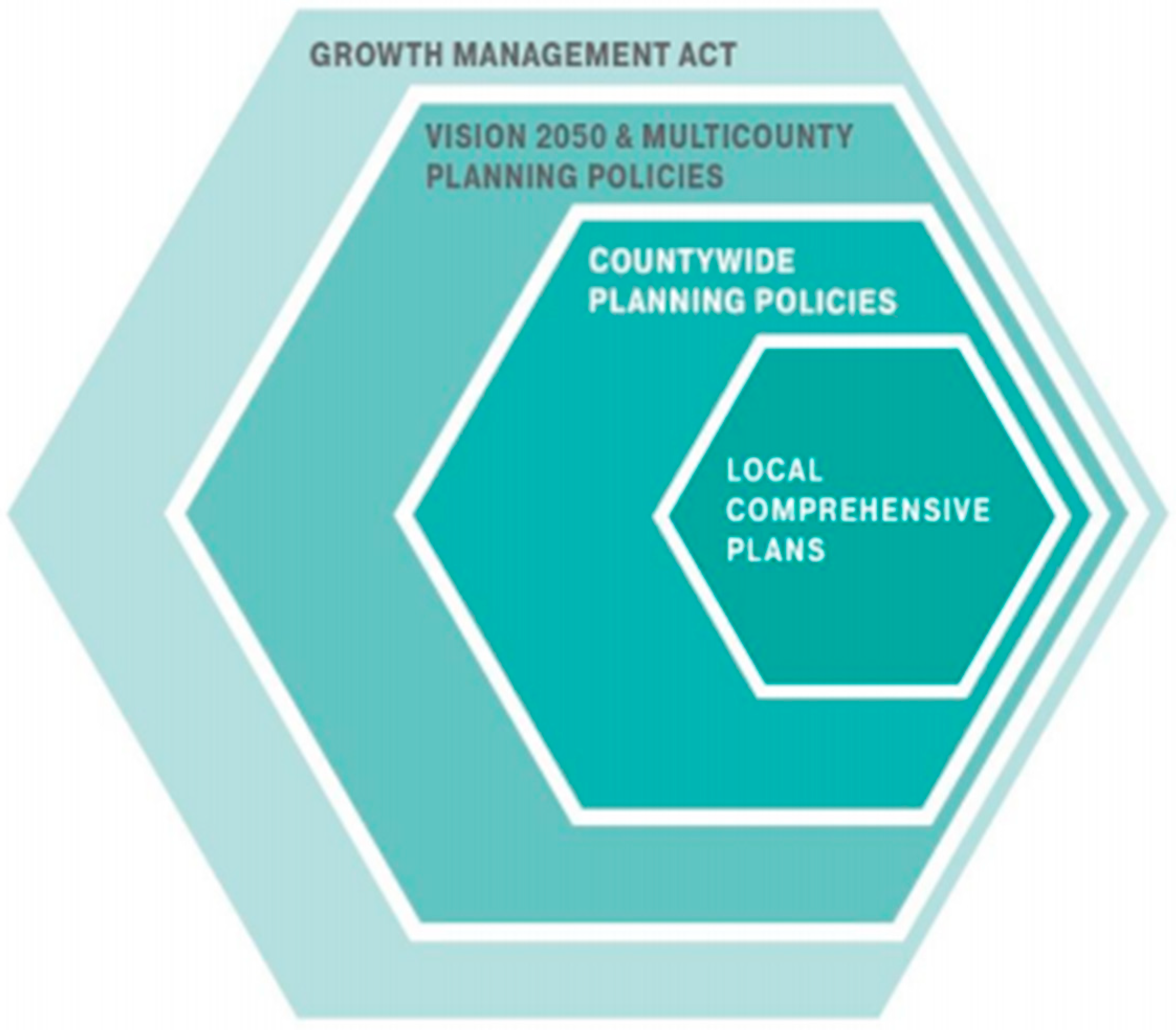
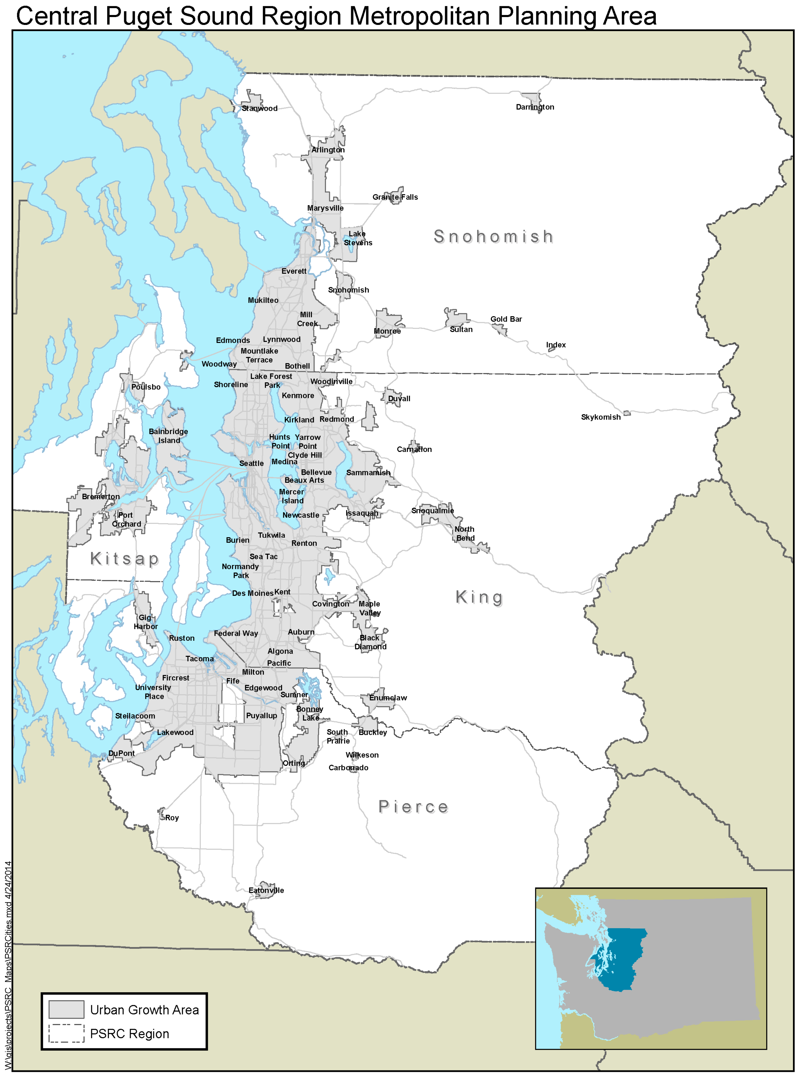
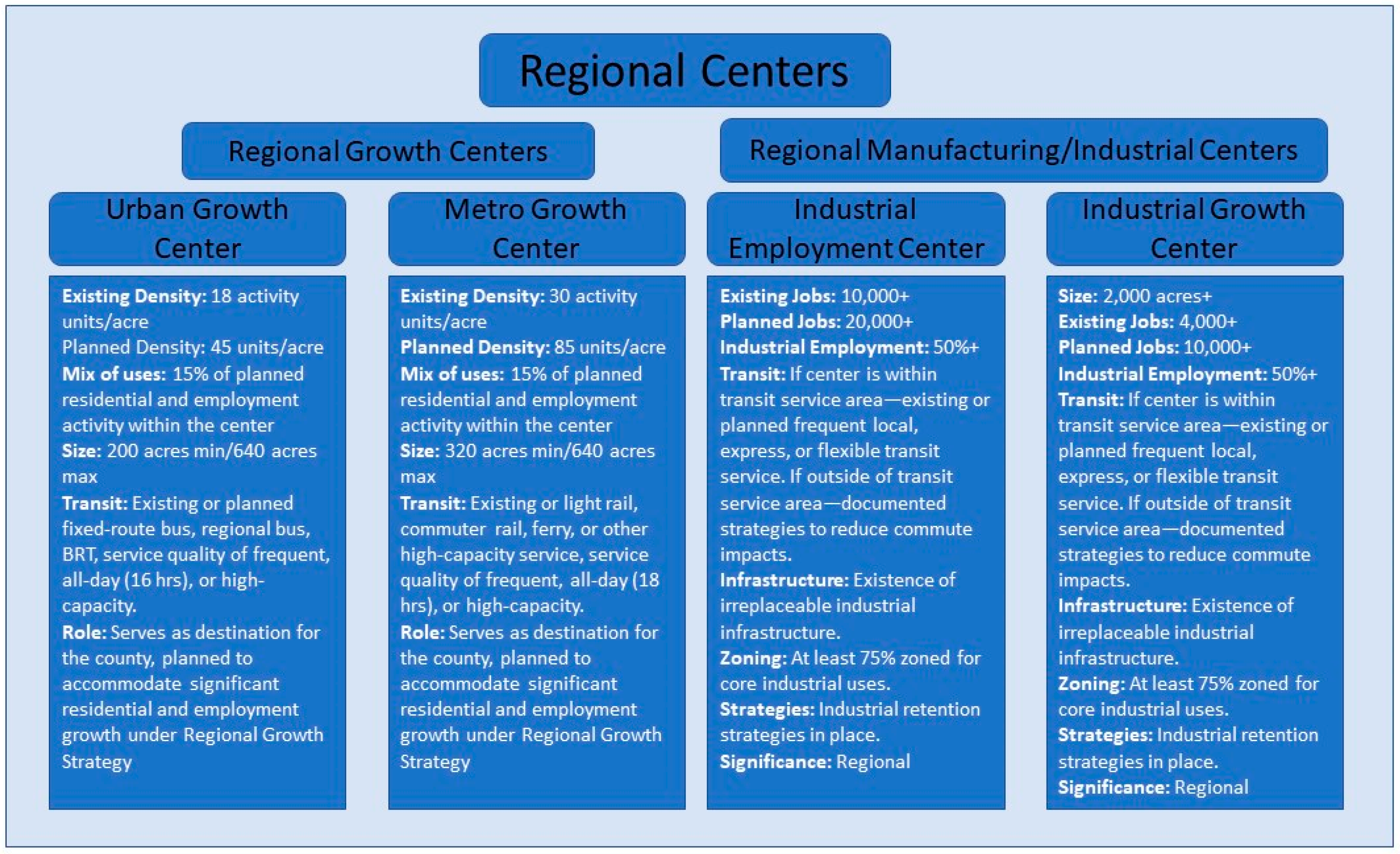
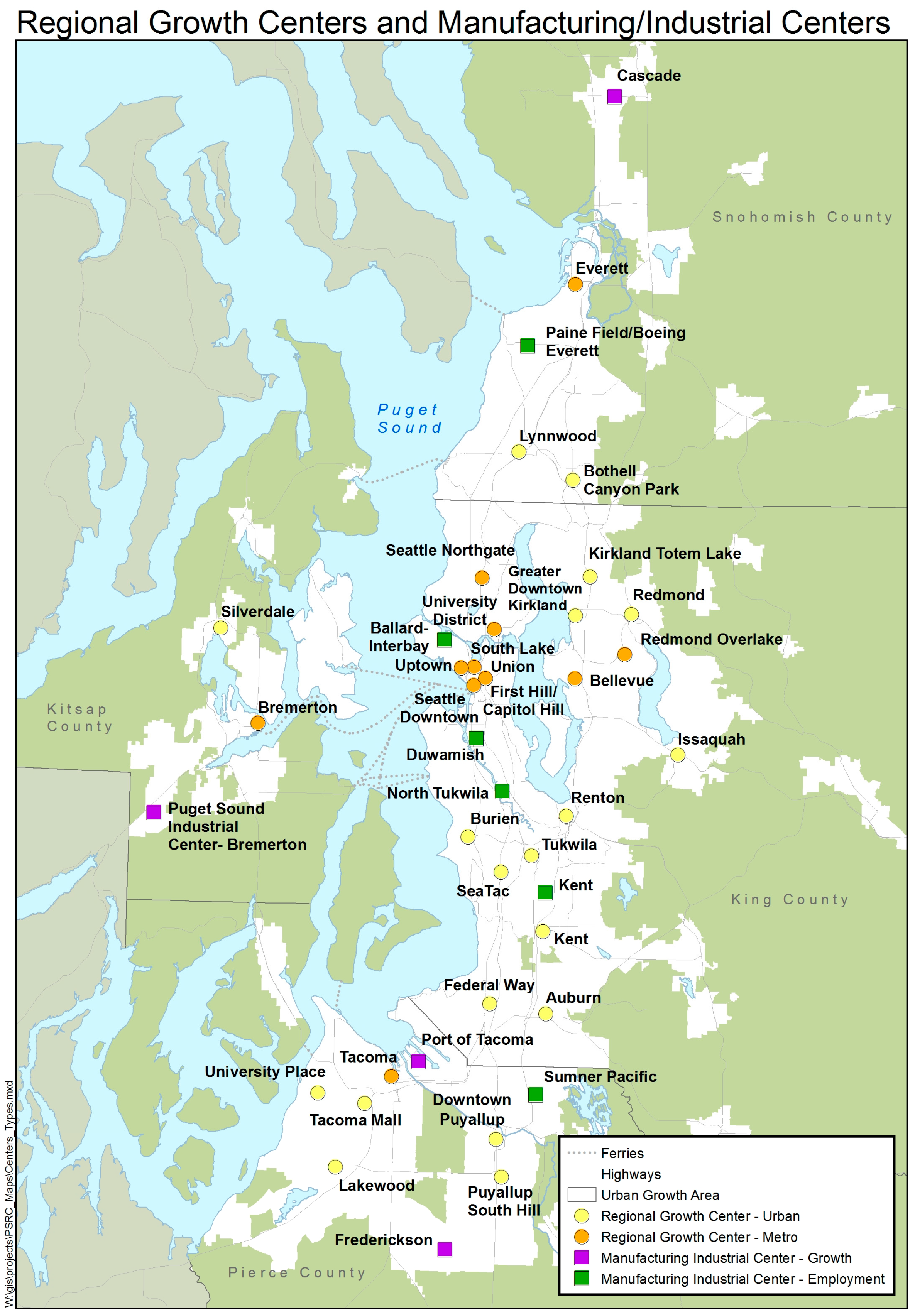
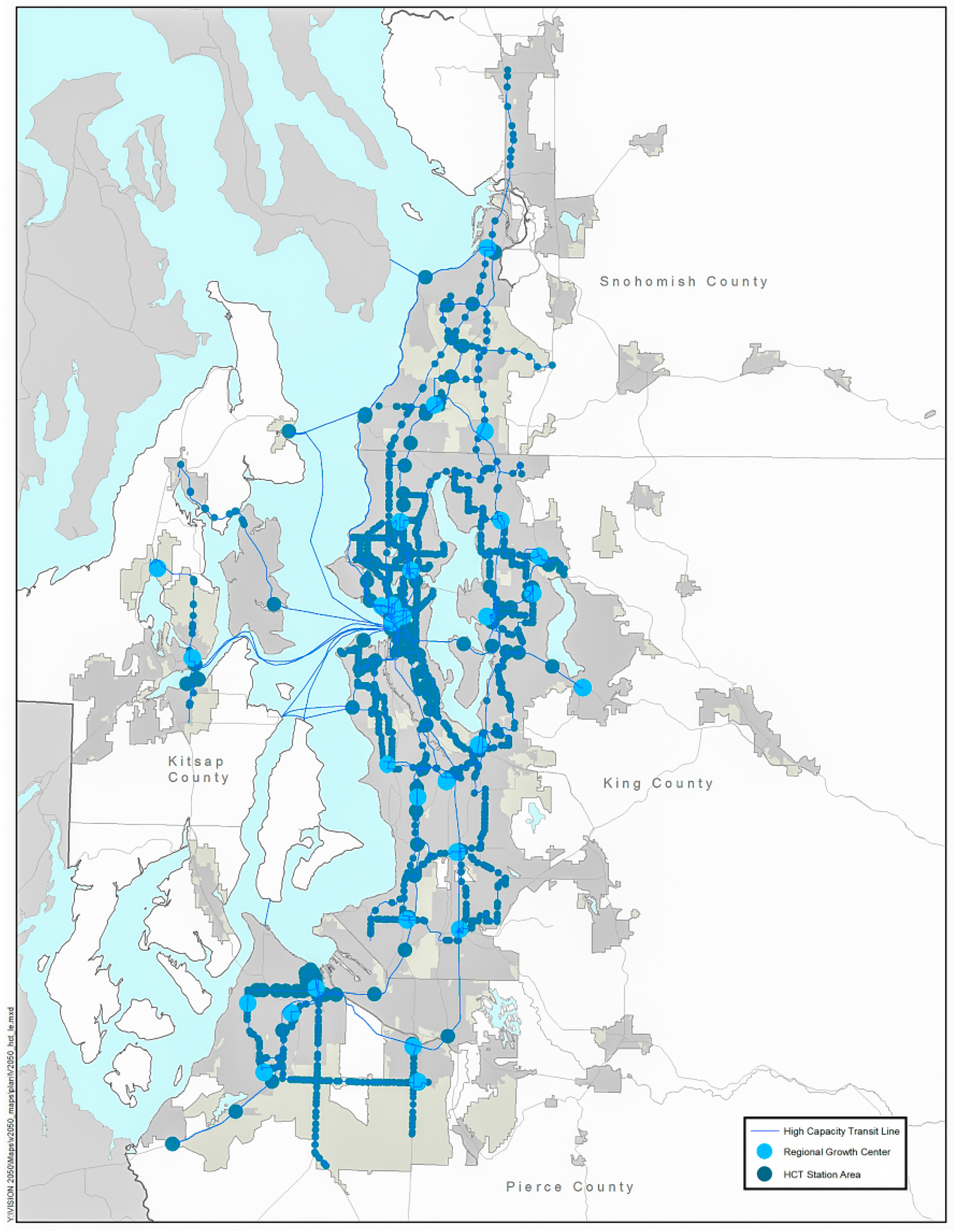
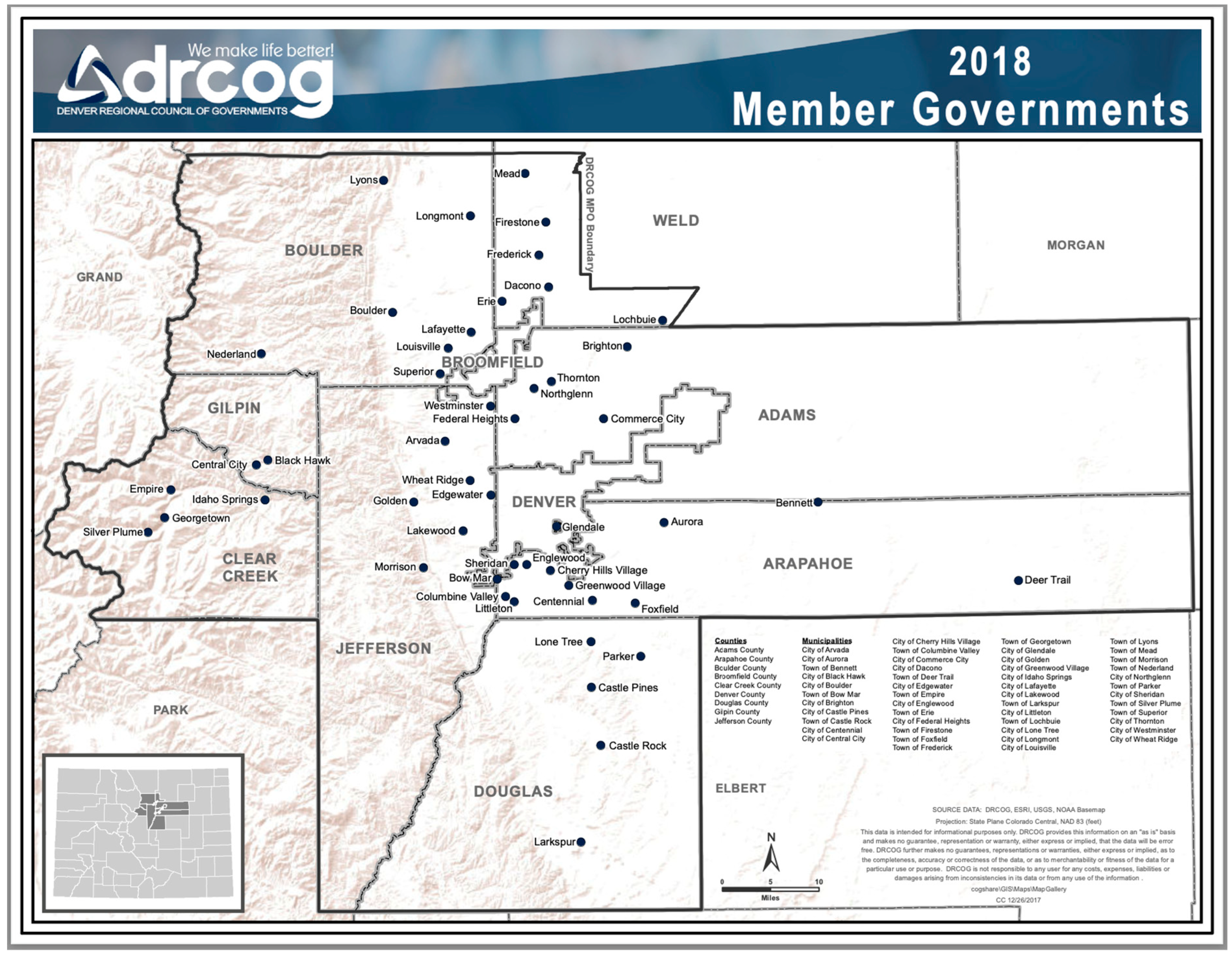
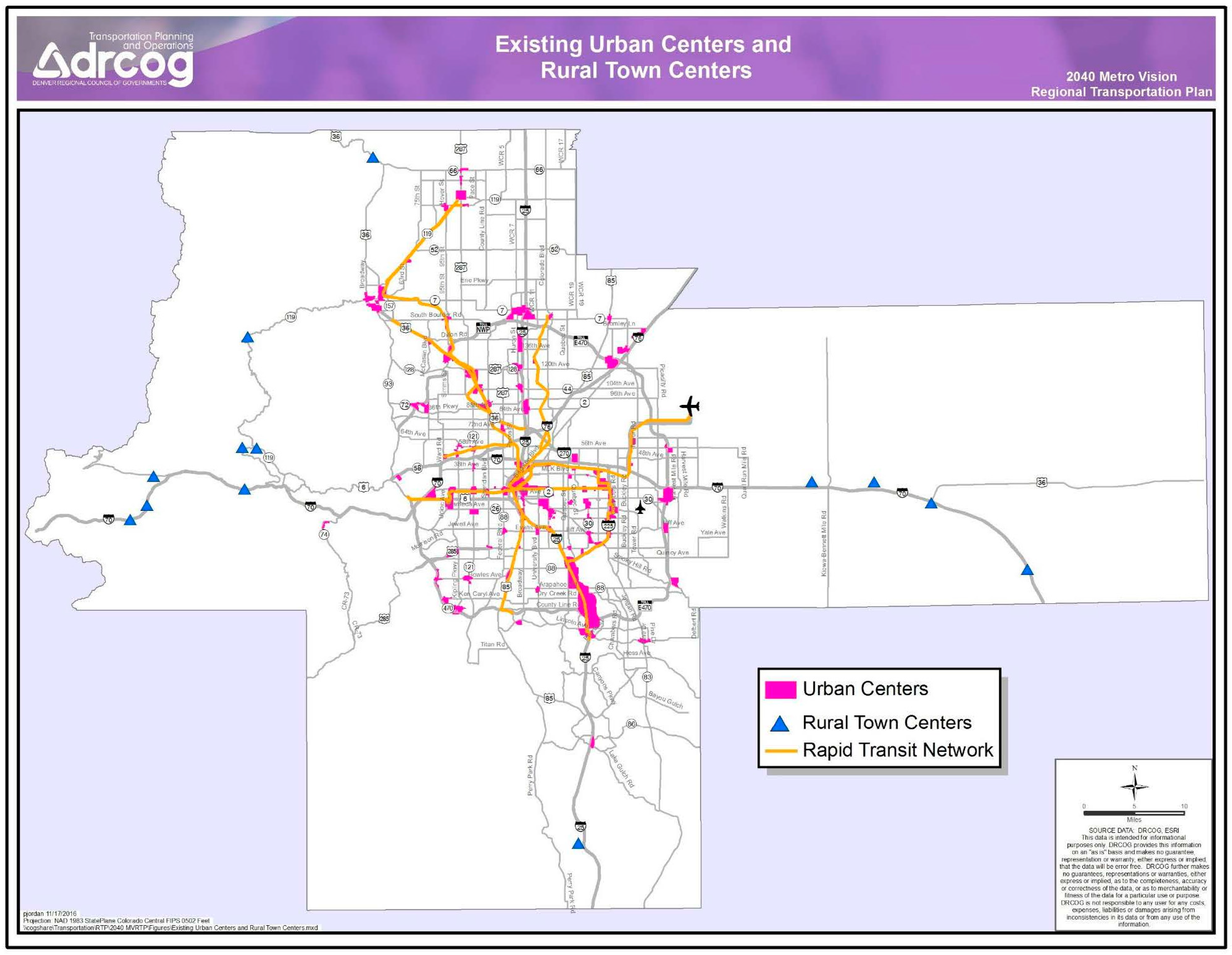
Disclaimer/Publisher’s Note: The statements, opinions and data contained in all publications are solely those of the individual author(s) and contributor(s) and not of MDPI and/or the editor(s). MDPI and/or the editor(s) disclaim responsibility for any injury to people or property resulting from any ideas, methods, instructions or products referred to in the content. |
© 2024 by the authors. Licensee MDPI, Basel, Switzerland. This article is an open access article distributed under the terms and conditions of the Creative Commons Attribution (CC BY) license (https://creativecommons.org/licenses/by/4.0/).