
Assessing Long-Term Thermal Environment Change with Landsat Time-Series Data in a Rapidly Urbanizing City in China

 , ,
, ,
Abstract
1. Introduction
2. Materials and Methods
2.1. Study Area
2.2. Land Surface Temperature Calculation
2.3. Analyzing Urban Thermal Environment Change between 1990 and 2020
2.3.1. Land Surface Temperature Change Analysis
2.3.2. Surface Urban Heat Island Intensity Change Analysis
2.3.3. Urban Heat Island Exposure Change Analysis
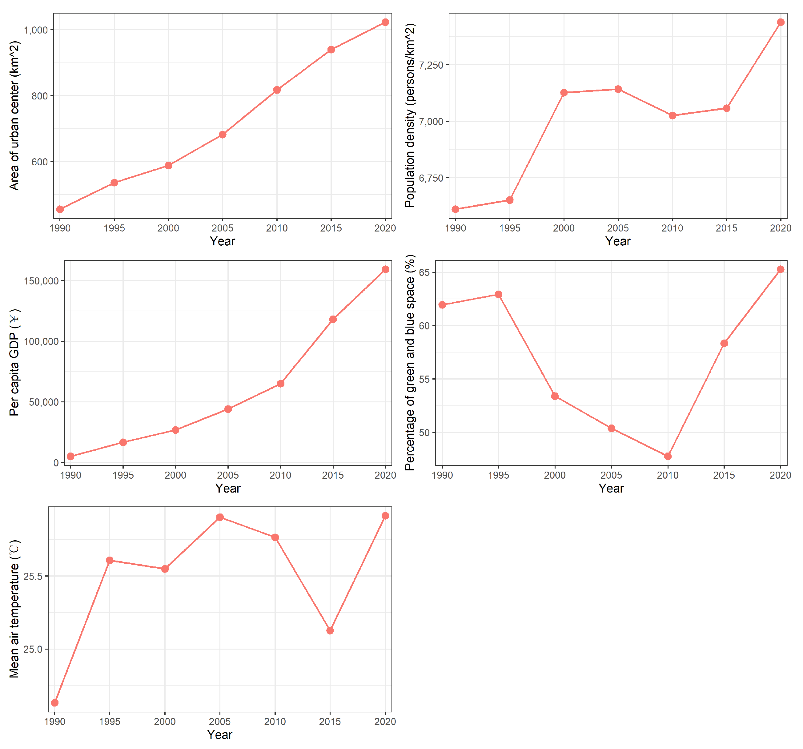
2.4. Analyzing Potential Driving Factors of Urban Thermal Environment Change
3. Results
3.1. Results of Land Surface Temperature Change from 1990 to 2020
3.2. Results of Surface Heat Island Intensity Change from 1990 to 2020
3.3. Results of Urban Heat Island Exposure Change from 1990 to 2020
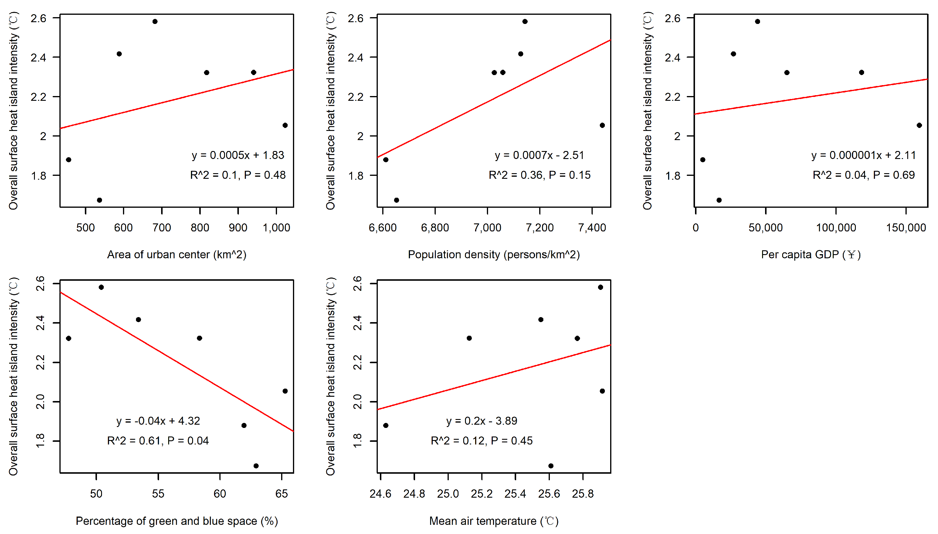
3.4. Relationships between the Overall Surface Urban Heat Island Intensity and Potential Drivers
4. Discussion
4.1. Assessing Urban Thermal Environment Change with Landsat Time-Series Data
4.2. The Potential Factors Affecting Urban Thermal Environment Change
4.3. Limitations of This Study
5. Conclusions
Author Contributions
Funding
Data Availability Statement
Conflicts of Interest
References
- United Nations Economic & Social Affairs. World Urbanization Prospect: The 2018 Revision; United Nations Economic & Social Affairs: New York, NY, USA, 2019. [Google Scholar]
- Peng, J.; Xie, P.; Liu, Y.; Ma, J. Urban Thermal Environment Dynamics and Associated Landscape Pattern Factors: A Case Study in the Beijing Metropolitan Region. Remote Sens. Environ. 2016, 173, 145–155. [Google Scholar] [CrossRef]
- Huang, C.; Xu, N. Quantifying Urban Expansion from 1985 to 2018 in Large Cities Worldwide. Geocarto Int. 2022, 37, 18356–18371. [Google Scholar] [CrossRef]
- Gao, Z.; Hou, Y.; Chen, W. Enhanced Sensitivity of the Urban Heat Island Effect to Summer Temperatures Induced by Urban Expansion. Environ. Res. Lett. 2019, 14, 094005. [Google Scholar] [CrossRef]
- Liu, H.; Cui, W.; Zhang, M. Exploring the Causal Relationship between Urbanization and Air Pollution: Evidence from China. Sustain. Cities Soc. 2022, 80, 103783. [Google Scholar] [CrossRef]
- McDonald, R.I.; Mansur, A.V.; Ascensão, F.; Colbert, M.; Crossman, K.; Elmqvist, T.; Gonzalez, A.; Güneralp, B.; Haase, D.; Hamann, M.; et al. Research Gaps in Knowledge of the Impact of Urban Growth on Biodiversity. Nat. Sustain. 2020, 3, 16–24. [Google Scholar] [CrossRef]
- Heaviside, C.; Vardoulakis, S.; Cai, X.-M. Attribution of Mortality to the Urban Heat Island during Heatwaves in the West Midlands, UK. Environ. Health 2016, 15, S27. [Google Scholar] [CrossRef]
- Li, X.; Zhou, Y.; Yu, S.; Jia, G.; Li, H.; Li, W. Urban Heat Island Impacts on Building Energy Consumption: A Review of Approaches and Findings. Energy 2019, 174, 407–419. [Google Scholar] [CrossRef]
- Zhou, D.; Xiao, J.; Bonafoni, S.; Berger, C.; Deilami, K.; Zhou, Y.; Frolking, S.; Yao, R.; Qiao, Z.; Sobrino, J.A. Satellite Remote Sensing of Surface Urban Heat Islands: Progress, Challenges, and Perspectives. Remote Sens. 2019, 11, 48. [Google Scholar] [CrossRef]
- Voogt, J.A.; Oke, T.R. Thermal Remote Sensing of Urban Climates. Remote Sens. Environ. 2003, 86, 370–384. [Google Scholar] [CrossRef]
- Clinton, N.; Gong, P. MODIS Detected Surface Urban Heat Islands and Sinks: Global Locations and Controls. Remote Sens. Environ. 2013, 134, 294–304. [Google Scholar] [CrossRef]
- Garuma, G.F. Tropical Surface Urban Heat Islands in East Africa. Sci. Rep. 2023, 13, 4509. [Google Scholar] [CrossRef] [PubMed]
- Li, H.; Zhou, Y.; Li, X.; Meng, L.; Wang, X.; Wu, S.; Sodoudi, S. A New Method to Quantify Surface Urban Heat Island Intensity. Sci. Total Environ. 2018, 624, 262–272. [Google Scholar] [CrossRef] [PubMed]
- Manoli, G.; Fatichi, S.; Schläpfer, M.; Yu, K.; Crowther, T.W.; Meili, N.; Burlando, P.; Katul, G.G.; Bou-Zeid, E. Magnitude of Urban Heat Islands Largely Explained by Climate and Population. Nature 2019, 573, 55–60. [Google Scholar] [CrossRef] [PubMed]
- Peng, S.; Piao, S.; Ciais, P.; Friedlingstein, P.; Ottle, C.; Bréon, F.-M.; Nan, H.; Zhou, L.; Myneni, R.B. Surface Urban Heat Island Across 419 Global Big Cities. Environ. Sci. Technol. 2012, 46, 696–703. [Google Scholar] [CrossRef] [PubMed]
- Schwaab, J.; Meier, R.; Mussetti, G.; Seneviratne, S.; Bürgi, C.; Davin, E.L. The Role of Urban Trees in Reducing Land Surface Temperatures in European Cities. Nat. Commun. 2021, 12, 6763. [Google Scholar] [CrossRef]
- Zhou, D.; Zhao, S.; Liu, S.; Zhang, L.; Zhu, C. Surface Urban Heat Island in China’s 32 Major Cities: Spatial Patterns and Drivers. Remote Sens. Environ. 2014, 152, 51–61. [Google Scholar] [CrossRef]
- Zhou, W.; Qian, Y.; Li, X.; Li, W.; Han, L. Relationships between Land Cover and the Surface Urban Heat Island: Seasonal Variability and Effects of Spatial and Thematic Resolution of Land Cover Data on Predicting Land Surface Temperatures. Landsc. Ecol. 2014, 29, 153–167. [Google Scholar] [CrossRef]
- Meyer, H.; Katurji, M.; Appelhans, T.; Müller, M.U.; Nauss, T.; Roudier, P.; Zawar-Reza, P. Mapping Daily Air Temperature for Antarctica Based on MODIS LST. Remote Sens. 2016, 8, 732. [Google Scholar] [CrossRef]
- Dewan, A.; Kiselev, G.; Botje, D.; Mahmud, G.I.; Bhuian, M.H.; Hassan, Q.K. Surface Urban Heat Island Intensity in Five Major Cities of Bangladesh: Patterns, Drivers and Trends. Sustain. Cities Soc. 2021, 71, 102926. [Google Scholar] [CrossRef]
- Morabito, M.; Crisci, A.; Guerri, G.; Messeri, A.; Congedo, L.; Munafò, M. Surface Urban Heat Islands in Italian Metropolitan Cities: Tree Cover and Impervious Surface Influences. Sci. Total Environ. 2021, 751, 142334. [Google Scholar] [CrossRef]
- Peng, X.; Zhou, Y.; Fu, X.; Xu, J. Study on the Spatial-Temporal Pattern and Evolution of Surface Urban Heat Island in 180 Shrinking Cities in China. Sustain. Cities Soc. 2022, 84, 104018. [Google Scholar] [CrossRef]
- Wang, Z.; Meng, Q.; Allam, M.; Hu, D.; Zhang, L.; Menenti, M. Environmental and Anthropogenic Drivers of Surface Urban Heat Island Intensity: A Case-Study in the Yangtze River Delta, China. Ecol. Indic. 2021, 128, 107845. [Google Scholar] [CrossRef]
- Liu, H.; He, B.; Gao, S.; Zhan, Q.; Yang, C. Influence of Non-Urban Reference Delineation on Trend Estimate of Surface Urban Heat Island Intensity: A Comparison of Seven Methods. Remote Sens. Environ. 2023, 296, 113735. [Google Scholar] [CrossRef]
- Ali, J.M.; Marsh, S.H.; Smith, M.J. A Comparison between London and Baghdad Surface Urban Heat Islands and Possible Engineering Mitigation Solutions. Sustain. Cities Soc. 2017, 29, 159–168. [Google Scholar] [CrossRef]
- Bhang, K.J.; Park, S.-S. Evaluation of the Surface Temperature Variation With Surface Settings on the Urban Heat Island in Seoul, Korea, Using Landsat-7 ETM+ and SPOT. IEEE Geosci. Remote Sens. Lett. 2009, 6, 708–712. [Google Scholar] [CrossRef]
- Cao, X.; Onishi, A.; Chen, J.; Imura, H. Quantifying the Cool Island Intensity of Urban Parks Using ASTER and IKONOS Data. Landsc. Urban Plan. 2010, 96, 224–231. [Google Scholar] [CrossRef]
- Connors, J.P.; Galletti, C.S.; Chow, W.T.L. Landscape Configuration and Urban Heat Island Effects: Assessing the Relationship between Landscape Characteristics and Land Surface Temperature in Phoenix, Arizona. Landsc. Ecol. 2013, 28, 271–283. [Google Scholar] [CrossRef]
- Hou, H.; Estoque, R.C. Detecting Cooling Effect of Landscape from Composition and Configuration: An Urban Heat Island Study on Hangzhou. Urban For. Urban Green. 2020, 53, 126719. [Google Scholar] [CrossRef]
- Sultana, S.; Satyanarayana, A.N.V. Assessment of Urbanisation and Urban Heat Island Intensities Using Landsat Imageries during 2000–2018 over a Sub-Tropical Indian City. Sustain. Cities Soc. 2020, 52, 101846. [Google Scholar] [CrossRef]
- Weng, Q.; Lu, D.; Schubring, J. Estimation of Land Surface Temperature–Vegetation Abundance Relationship for Urban Heat Island Studies. Remote Sens. Environ. 2004, 89, 467–483. [Google Scholar] [CrossRef]
- Yu, Z.; Yao, Y.; Yang, G.; Wang, X.; Vejre, H. Spatiotemporal Patterns and Characteristics of Remotely Sensed Region Heat Islands during the Rapid Urbanization (1995–2015) of Southern China. Sci. Total Environ. 2019, 674, 242–254. [Google Scholar] [CrossRef]
- Yuan, F.; Bauer, M.E. Comparison of Impervious Surface Area and Normalized Difference Vegetation Index as Indicators of Surface Urban Heat Island Effects in Landsat Imagery. Remote Sens. Environ. 2007, 106, 375–386. [Google Scholar] [CrossRef]
- Zhao, Z.; Sharifi, A.; Dong, X.; Shen, L.; He, B.-J. Spatial Variability and Temporal Heterogeneity of Surface Urban Heat Island Patterns and the Suitability of Local Climate Zones for Land Surface Temperature Characterization. Remote Sens. 2021, 13, 4338. [Google Scholar] [CrossRef]
- Zhang, M.; Dong, S.; Cheng, H.; Li, F. Spatio-Temporal Evolution of Urban Thermal Environment and Its Driving Factors: Case Study of Nanjing, China. PLoS ONE 2021, 16, e0246011. [Google Scholar] [CrossRef] [PubMed]
- Reiners, P.; Sobrino, J.; Kuenzer, C. Satellite-Derived Land Surface Temperature Dynamics in the Context of Global Change—A Review. Remote Sens. 2023, 15, 1857. [Google Scholar] [CrossRef]
- Huang, C.; Yang, J.; Clinton, N.; Yu, L.; Huang, H.; Dronova, I.; Jin, J. Mapping the Maximum Extents of Urban Green Spaces in 1039 Cities Using Dense Satellite Images. Environ. Res. Lett. 2021, 16, 064072. [Google Scholar] [CrossRef]
- Hou, H.; Su, H.; Liu, K.; Li, X.; Chen, S.; Wang, W.; Lin, J. Driving Forces of UHI Changes in China’s Major Cities from the Perspective of Land Surface Energy Balance. Sci. Total Environ. 2022, 829, 154710. [Google Scholar] [CrossRef]
- Hu, J.; Yang, Y.; Zhou, Y.; Zhang, T.; Ma, Z.; Meng, X. Spatial Patterns and Temporal Variations of Footprint and Intensity of Surface Urban Heat Island in 141 China Cities. Sustain. Cities Soc. 2022, 77, 103585. [Google Scholar] [CrossRef]
- Yao, R.; Wang, L.; Huang, X.; Niu, Z.; Liu, F.; Wang, Q. Temporal Trends of Surface Urban Heat Islands and Associated Determinants in Major Chinese Cities. Sci. Total Environ. 2017, 609, 742–754. [Google Scholar] [CrossRef]
- National Bureau of Statistics of China. China City Statistical Yearbook; China Statistics Press: Beijing, China, 2021.
- Schiavina, M.; Melchiorri, M.; Pesaresi, M. GHS-SMOD R2023A—GHS Settlement Layers, Application of the Degree of Urbanisation Methodology (Stage I) to GHS-POP R2023A and GHS-BUILT-S R2023A, Multitemporal (1975–2030). Eur. Comm. Jt. Res. Cent. 2023. [Google Scholar] [CrossRef]
- Gorelick, N.; Hancher, M.; Dixon, M.; Ilyushchenko, S.; Thau, D.; Moore, R. Google Earth Engine: Planetary-Scale Geospatial Analysis for Everyone. Remote Sens. Environ. 2017, 202, 18–27. [Google Scholar] [CrossRef]
- Ermida, S.L.; Soares, P.; Mantas, V.; Göttsche, F.-M.; Trigo, I.F. Google Earth Engine Open-Source Code for Land Surface Temperature Estimation from the Landsat Series. Remote Sens. 2020, 12, 1471. [Google Scholar] [CrossRef]
- European Commission. GHSL Data Package. 2023. Available online: https://ghsl.jrc.ec.europa.eu/documents/GHSL_Data_Package_2023.pdf?t=1683540422 (accessed on 12 October 2023).
- Schiavina, M.; Freire, S.; Carioli, A.; MacManus, K. GHS-POP R2023A—GHS Population Grid Multitemporal (1975–2030). Eur. Comm. Jt. Res. Cent. 2023. [Google Scholar] [CrossRef]
- Clinton, N.; Stuhlmacher, M.; Miles, A.; Uludere Aragon, N.; Wagner, M.; Georgescu, M.; Herwig, C.; Gong, P. A Global Geospatial Ecosystem Services Estimate of Urban Agriculture. Earth’s Future 2018, 6, 40–60. [Google Scholar] [CrossRef]
- Pekel, J.-F.; Cottam, A.; Gorelick, N.; Belward, A.S. High-Resolution Mapping of Global Surface Water and Its Long-Term Changes. Nature 2016, 540, 418–422. [Google Scholar] [CrossRef] [PubMed]
- Hersbach, H.; Bell, B.; Berrisford, P.; Hirahara, S.; Horányi, A.; Muñoz-Sabater, J.; Nicolas, J.; Peubey, C.; Radu, R.; Schepers, D.; et al. The ERA5 Global Reanalysis. Q. J. R. Meteorol. Soc. 2020, 146, 1999–2049. [Google Scholar] [CrossRef]
- Li, X.; Zhou, W. Spatial Patterns and Driving Factors of Surface Urban Heat Island Intensity: A Comparative Study for Two Agriculture-Dominated Regions in China and the USA. Sustain. Cities Soc. 2019, 48, 101518. [Google Scholar] [CrossRef]
- Si, M.; Li, Z.-L.; Tang, B.-H.; Liu, X.; Nerry, F. Spatial Heterogeneity of Driving Factors-Induced Impacts for Global Long-Term Surface Urban Heat Island. Int. J. Remote Sens. 2023, 1–21. [Google Scholar] [CrossRef]
- Gunawardena, K.R.; Wells, M.J.; Kershaw, T. Utilising Green and Bluespace to Mitigate Urban Heat Island Intensity. Sci. Total Environ. 2017, 584, 1040–1055. [Google Scholar] [CrossRef]
- Peng, J.; Liu, Q.; Xu, Z.; Lyu, D.; Du, Y.; Qiao, R.; Wu, J. How to Effectively Mitigate Urban Heat Island Effect? A Perspective of Waterbody Patch Size Threshold. Landsc. Urban Plan. 2020, 202, 103873. [Google Scholar] [CrossRef]
- Zhang, Y.; Murray, A.T.; Turner, B.L. Optimizing Green Space Locations to Reduce Daytime and Nighttime Urban Heat Island Effects in Phoenix, Arizona. Landsc. Urban Plan. 2017, 165, 162–171. [Google Scholar] [CrossRef]
- Southworth, J. An Assessment of Landsat TM Band 6 Thermal Data for Analysing Land Cover in Tropical Dry Forest Regions. Int. J. Remote Sens. 2004, 25, 689–706. [Google Scholar] [CrossRef]


| Year | Surface Urban Heat Islands Intensity (°C) | ||||||
|---|---|---|---|---|---|---|---|
| ≤0 | (0,1] | (1,2] | (2,3] | (3,4] | (4,5] | >5 | |
| 1990 | 76,705 | 196,098 | 319,087 | 385,055 | 5001,52 | 474,166 | 1,069,998 |
| 1995 | 142,188 | 234,818 | 454,945 | 753,338 | 757,892 | 554,040 | 681,541 |
| 2000 | 26,852 | 122,818 | 287,449 | 486,777 | 682,679 | 877,881 | 1,719,918 |
| 2005 | 36,189 | 119,740 | 292,631 | 525,420 | 997,123 | 1,286,951 | 1,627,323 |
| 2010 | 41,410 | 144,567 | 483,999 | 1,237,393 | 1,841,762 | 1,296,642 | 715,018 |
| 2015 | 78,844 | 270,970 | 876,222 | 1,618,205 | 1,777,307 | 1,153,347 | 880,790 |
| 2020 | 165,002 | 451,264 | 1,110,024 | 1,859,535 | 1,984,787 | 1,225,830 | 834,922 |
| Year | Surface Urban Heat Island Intensity (°C) | ||||||
|---|---|---|---|---|---|---|---|
| ≤0 | (0,1] | (1,2] | (2,3] | (3,4] | (4,5] | >5 | |
| 1990 | 2.54 | 6.49 | 10.56 | 12.74 | 16.55 | 15.69 | 35.42 |
| 1995 | 3.97 | 6.56 | 12.71 | 21.05 | 21.18 | 15.48 | 19.04 |
| 2000 | 0.64 | 2.92 | 6.84 | 11.58 | 16.24 | 20.88 | 40.91 |
| 2005 | 0.74 | 2.45 | 5.99 | 10.75 | 20.41 | 26.34 | 33.31 |
| 2010 | 0.72 | 2.51 | 8.40 | 21.48 | 31.97 | 22.51 | 12.41 |
| 2015 | 1.18 | 4.07 | 13.17 | 24.31 | 26.70 | 17.33 | 13.23 |
| 2020 | 2.16 | 5.91 | 14.55 | 24.37 | 26.01 | 16.06 | 10.94 |
| Mean | 1.71 | 4.42 | 10.32 | 18.04 | 22.72 | 19.19 | 23.61 |
Disclaimer/Publisher’s Note: The statements, opinions and data contained in all publications are solely those of the individual author(s) and contributor(s) and not of MDPI and/or the editor(s). MDPI and/or the editor(s) disclaim responsibility for any injury to people or property resulting from any ideas, methods, instructions or products referred to in the content. |
© 2024 by the authors. Licensee MDPI, Basel, Switzerland. This article is an open access article distributed under the terms and conditions of the Creative Commons Attribution (CC BY) license (https://creativecommons.org/licenses/by/4.0/).
Share and Cite
Huang, C.; Tang, Y.; Wu, Y.; Tao, Y.; Xu, M.; Xu, N.; Li, M.; Liu, X.; Xi, H.; Ou, W. Assessing Long-Term Thermal Environment Change with Landsat Time-Series Data in a Rapidly Urbanizing City in China. Land 2024, 13, 177. https://doi.org/10.3390/land13020177
Huang C, Tang Y, Wu Y, Tao Y, Xu M, Xu N, Li M, Liu X, Xi H, Ou W. Assessing Long-Term Thermal Environment Change with Landsat Time-Series Data in a Rapidly Urbanizing City in China. Land. 2024; 13(2):177. https://doi.org/10.3390/land13020177
Chicago/Turabian StyleHuang, Conghong, Yan Tang, Yiyang Wu, Yu Tao, Muwu Xu, Nan Xu, Mingze Li, Xiaodan Liu, Henghui Xi, and Weixin Ou. 2024. "Assessing Long-Term Thermal Environment Change with Landsat Time-Series Data in a Rapidly Urbanizing City in China" Land 13, no. 2: 177. https://doi.org/10.3390/land13020177
APA StyleHuang, C., Tang, Y., Wu, Y., Tao, Y., Xu, M., Xu, N., Li, M., Liu, X., Xi, H., & Ou, W. (2024). Assessing Long-Term Thermal Environment Change with Landsat Time-Series Data in a Rapidly Urbanizing City in China. Land, 13(2), 177. https://doi.org/10.3390/land13020177