Abstract
Agroecological transition requires research and actions at the scale of local territories, in which agricultural activities interact with the environment and natural resources depending on a territory’s spatial configuration. To support the agroecological transition, there is an urgent need to design and implement new spatial configurations. For this, local public authorities in France can be considered as an interesting level of governance, because of their skills in spatial planning and their interest in agriculture, to ensure the ecological transition of their territory. However, new methodological frameworks need to be developed to support the design of new spatial configurations of territories, by constructing representations of the territory that consider both agricultural and socio-environmental issues, and by involving agricultural and non-agricultural stakeholders so that both can project themselves into the new spatial configurations. We developed a new methodological framework at the interface between landscape agronomy and landscape architects’ approaches, and experimented with applying this framework in the Urban Community of Dunkirk (UCD), which was performing a spatial planning approach called a Landscape Plan and proposing to create an Agricultural Park. The results show that the implementation of the methodological framework enabled the construction of a spatially explicit and place-based representation including the spatial issues of farming systems. These representations enable a local authority’s stakeholders to enhance their knowledge of the agricultural issues and consider changes in the spatial configuration of the Agricultural Park. In the discussion, we question the adaptation of the framework in rural territory and highlight the limitations of local authorities as the level of governance at which to address the agroecological transition at the territorial scale.
1. Introduction
In France, as in many other Western countries, agriculture has been transformed greatly over the past 70 years. The historical agricultural and agri-food model has been replaced by agro-industrial systems, which are embedded in national and international supply and distribution markets. This transformation has involved an increase in yields, decrease in the number of farms, specialisation of production systems, and major changes to rural landscapes. The current context of environmental and social changes calls for new agricultural models, such as agroecology [1]. The agroecological transition of systems and territories has been identified as a way to design multifunctional territories that can meet a variety of social and environmental challenges. Indeed, in addition to producing agricultural goods and benefits for farmers, agroecological systems are expected to provide a wide range of functions and services for society, such as protecting natural resources, mitigating and adapting to climate change, maintaining biodiversity, protecting against environmental risks (e.g., erosion, flood), maintaining amenities and the quality of life, and producing local food [2]. Agroecological transition requires research and actions at the scale of local territories, in which the agricultural activities interact with the environment and natural resources (e.g., water, soil, biodiversity), including interactions among farming systems, cultivated and semi-natural areas, and agricultural and non-agricultural activities [3]. These interactions are strongly influenced by a territory’s spatial configuration, which we define as the spatial organisation and interactions of the multiple components of a territory in agricultural areas (e.g., fields, streams, hedges, woods, buildings, roads, paths), which depend on their use, location, size, and composition. Thus, there is an urgent need to support the design of and evolution to spatial configurations of territories that are suitable for agroecology [4,5]. Addressing this complexity requires transdisciplinary knowledge from research and practice, holistic approaches, and stakeholder engagement in co-designing the objectives and processes of transition [6]. In France, farmers’ groups exist that address agroecological issues collectively (e.g., refs. [7,8,9]). Although some operate at the territorial scale, they focus mainly on sharing practices or organising work, with little or no consideration of the spatial configuration of land use and management.
Local public authorities (e.g., municipality, group of municipalities) in France can be considered as an interesting level of governance at which to address agroecological transition [10]. Local authorities have skills in terms of spatial planning and territorial development at the territorial scale [11]. They plan land use changes in spatial configurations over the long term, such as in regulatory urban-planning documents. Long considered as a land reserve for urban development, agricultural areas have gradually become spaces that need to be protected from development [12]. In addition, due to the gradual political decentralisation over the past 40 years, local authorities have had to address an increasing diversity of issues to ensure the ecological transition of their territory, such as the preservation of biodiversity and water quality, renewable energy production, local food production, the quality of the living environment, and climate change management [13]. Although they have no jurisdiction over agricultural activities, local authorities have many expectations about agriculture, especially in territories with high pressure on the use of space, such as peri-urban areas, where local authorities expect multifunctional agriculture to develop [14]. The multifunctionality of agroecological systems can help meet these challenges.
To address the spatial issues of the agroecological transition at the territorial scale, new methodological frameworks need to be developed. These frameworks should provide shared spatial representations that include both the agricultural and socio-environmental issues of territories, and support the multi-stakeholder design process toward new multifunctional spatial configurations. To this end, we developed a new methodological framework at the interface between landscape agronomy and landscape architects’ approaches: multi-stakeholder spatial projection. We experimented applying this framework in collaboration with local authorities during the development of the public policies for spatial planning and ecological transition that concerned agriculture in particular. This methodological framework could be used by local authority stakeholders who want to work on the evolution of the spatial configurations of their territories to make them more multifunctional, in line with the socio-environmental and agroecology transition issues. In this study, we examined a case study of the Urban Community of Dunkirk (UCD), a peri-urban territory in northern France, where industrial and coastal activities generate high pressure on agriculture and strong challenges to maintaining it in the territory and its agroecological transition. After describing the application of the initial steps of multi-stakeholder spatial projection with the managers of the UCD, we discuss the strengths, limitations, and potential future developments of this new framework.
2. A New Methodological Framework Towards Designing Spatial Configurations for Agroecology at the Territorial Scale
2.1. Landscape Agronomy: Farming Systems as a Main Driver of the Spatial Configurations of Territories for Agroecology
Agriculture has many kinds of spatial relationships with the territories in which it occurs. Landscape agronomy has identified the relationships among farming practices, natural resources, and landscape patterns that are involved in the dynamics of the spatial configuration of agricultural landscapes [15]. Agriculture and the spatial configuration of a territory influence each other: the types of farming systems and how they are aggregated at the territorial scale shape the spatial configuration of agricultural areas, while the spatial configuration of natural resources and the landscape constrains the functioning of farming systems [16]. Through their systems and practices, farmers are the main managers of agricultural areas (i.e., fields and field margins), and they interact with patches of semi-natural habitats in or on the edges of agricultural areas. Indeed, farming systems determine crop mosaics (i.e., the type and combination of agricultural land uses) and the type and combination of the associated farming practices in fields [17]. Their influence extends beyond the field and annual crops to the types of ecological infrastructure managed by farmers, such as hedgerows [18] and riparian zones [19]. In return, these systems are influenced by the spatial organisation of fields, in particular their distance from the farm household and their accessibility, especially in livestock or mixed crop–livestock systems [20,21]. The spatial organisation can also influence the collaboration between farming systems, such as the fluxes of matter between crop and livestock systems [22]. Farming system functioning is also influenced by the access to natural resources, such as water or fertile soils [23], the infrastructure available to move machinery and livestock, and the proximity of non-agricultural land uses, such as housing and recreation. Consequently, the influence of the changes in farming systems on the changes in spatial configurations must be considered [24].
Industrial farming systems have been freed from some of these relationships with natural resources and landscape patterns by using synthetic inputs. However, agroecological transition calls for considerations regarding how to restore the interactions between farming systems and ecological processes, first by using ecosystem services. Depending on their spatial configuration, farming systems can rely on biological regulation to control pests [25], improve pollination [26], or manage weeds [27], and on micro-climate regulation to protect livestock and crops or improve the management of water volume [28]. Second, interactions between farming systems and ecological processes must be considered to decrease the impacts of farming systems on natural resources and thus ensure the provision of ecosystem services for society. Farming systems and spatial configurations influence the water quality and nitrate contamination [29,30], soil erosion [23], nutrient fluxes [31], climate [32], and biodiversity [33]. The spatial configurations that are suitable for these processes need to be considered to move towards multifunctional territories [34].
Given the importance of the interactions between farming systems and the spatial configurations of territories, we highlight that understanding the current spatial configurations and designing new ones for agroecology requires considering the specific issues of farming systems [35]. It is necessary to consider the spatial functioning of farming systems and ecological processes, as well as the spatial interactions among farming systems, ecological processes, and landscape patterns. The dynamics of farming systems also need to be considered, because changes in these systems can hinder or drive those in spatial configurations. Although landscape agronomy has identified these relationships, it provides few spatially explicit representations of them.
2.2. Landscape Architects’ Approaches for Designing New Multifunctional Spatial Configurations of Territories
Landscape architects are designers who plan new spatial configurations in urban, peri-urban, or rural territories over the long term. They develop specific approaches to consider a territory’s environmental and urban issues in the design of multifunctional landscapes that can respond to a variety of functions and uses [36]. Landscape architects work mainly with local authorities to support spatial planning that addresses the authorities’ issues for ecological transition [37]. In Europe, their approaches, based on the concept of landscape defined by the European Landscape Convention [38], have three main characteristics:
- In a place-based and spatially explicit way, analyse the current spatial configuration of a territory and consider the spatial configurations required to develop multiple uses. Combine these different spatial configurations to design a multifunctional area that is pleasant for all users and addresses the urban and environmental issues.
- Involve the different stakeholders of a territory to include their knowledge of the area and desire for change in the assessment and design process. To facilitate knowledge collection and discussions, focus on the sensory dimension of the landscape using images or field visits.
- Produce a map of the new spatial configuration of the territory designed. Stagger the transformations of spatial configuration over time to guide their implementation.
Landscape architects have shown an increasing interest in agriculture, particularly in education and training [39,40]. In research, landscape approaches, such as those developed by landscape architects in France, are recognised as a promising way to address the changes to the spatial configurations in rural territories [41,42,43]. Researchers in some European countries, such as Portugal and Denmark [44], have implemented these approaches, which enabled them to identify the strengths and limitations in rural territories.
To develop the approaches to address the spatial issues of agroecological transition at the territorial scale, we retained the ability to (i) consider multiple issues in a territory, such as rural development, nature conservation, and recreational access [45]; (ii) involve multiple stakeholders, such as village residents, the members of local associations, and municipal planners [46]; (iii) connect multiple sources of knowledge and develop a common language with powerful imagery and landscape narratives [47]; and (iv) guide spatial transformations in the long term, such as restoring stream meanders, establishing new walking trails, converting arable land to extensive grazing pastures, re-grazing abandoned pastures, or preserving historic features [48]. For agricultural issues, however, these approaches face difficulties in including agricultural stakeholders, helping farmers see their production activities as part of a common local context, and including a strategy for agriculture in the strategy for how a territory should evolve [47]. These limitations prevent the approaches from considering the spatial issues of farming systems highlighted by landscape agronomy.
2.3. A New Framework at the Interface between Landscape Architecture and Landscape Agronomy
We developed a methodological framework at the interface between landscape architects’ approaches and landscape agronomy toward designing new spatial configurations of the territory. This framework is a process of multi-stakeholder spatial projection based on the three characteristics of landscape architects’ approaches, which we modified to include the spatial issues of farming systems highlighted by landscape agronomy. Multi-stakeholder spatial projection has three principles:
- Include the spatial functioning of farming systems and ecological processes, as well as the spatial interactions among farming systems, ecological processes, and the spatial configurations of agricultural areas, in the place-based and spatially explicit analysis of the spatial configurations of the territory. Combine these spatial configurations specific to agriculture with those related to other territorial issues to imagine the changes in the spatial configuration of the territory.
- Involve both agricultural and non-agricultural stakeholders to include their knowledge of the territory and their desire for change in the assessment and design process. Agricultural stakeholders are farmers who make the decisions on agricultural land use and management depending on their farming systems, or their representatives. To do this, develop frameworks for meetings that are adapted to the specific professional characteristics of agricultural stakeholders (e.g., work rhythm, seasonality, constraints of livestock farming) and adapt the representations based on the sensory dimension of the landscape so that they can represent the spatial issues of agriculture. These representations should enable the stakeholders to share the knowledge about and discuss the multiple issues that face the area.
- Include the dynamics and uncertainties specific to agriculture in the process of designing the new spatial configurations and in the timescales planned for implementing the transformations. To do this, the aim of the process is not to produce a final alternative spatial configuration but to mobilize the spatial representations to enable the stakeholders to gradually imagine the transformations of the spatial configuration adapted to the changes in the issues, and in particular to the changes in the agricultural dynamics.
This framework is not a methodological tool that can be reproduced identically in different territories. It is a guide for developing approaches adapted to the specific characteristics of each territory, such as peri-urban or rural context, the main ecological issues, the types of farming systems, and the relationship between agricultural and non-agricultural local stakeholders. For the level of governance of local authorities, it should take into account the differences in the representation of the territory between the agricultural stakeholders and local authority stakeholders to build a representation that includes the spatial issues of farming systems and territorial issues of local authorities for ecological transition. This representation must support the discussions between the local agricultural stakeholders and local authority stakeholders to project the new spatial configurations of the territory for agroecology.
3. Application to the Urban Community of Dunkirk
Multi-stakeholder spatial projection was implemented between September 2022 and January 2024 as part of spatial planning approaches implemented by the local authorities of the UCD. We worked with the local authority stakeholders who are trying to address the agriculture in their spatial planning but who are faced with a lack of approaches for doing so. Due to the political tensions between the UCD and the local Chamber of Agriculture, the local agricultural stakeholders could not be involved.
3.1. Materials and Methods
3.1.1. The Territory of the Urban Community of Dunkirk
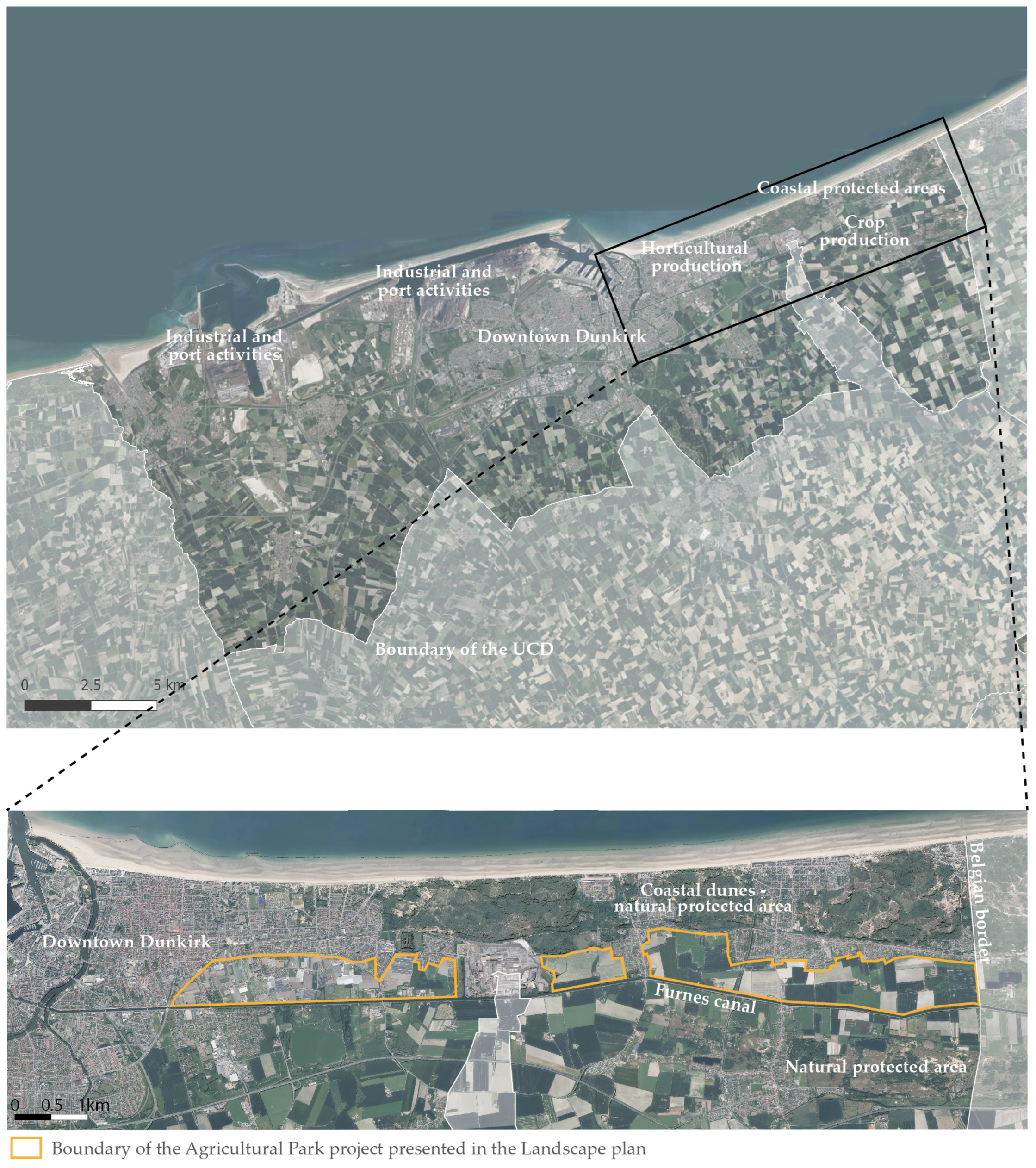
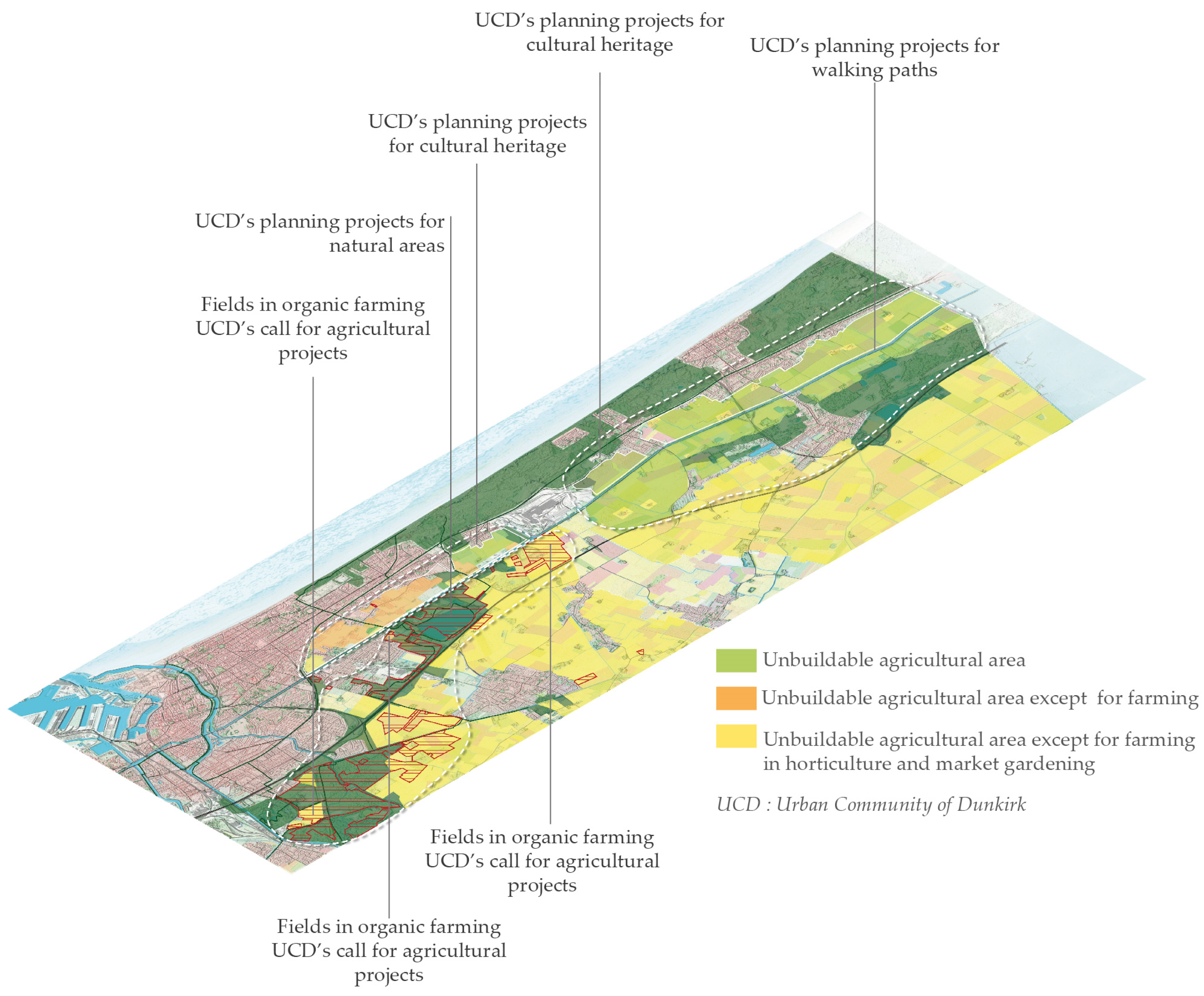
The local authority of the UCD, a dynamic urban territory of ca. 300 km2, is located on the coast of northern France (51°02′18″ N, 2°22′39″ E) and has a population of ca. 192 600 inhabitants. It experiences high pressure for the use of space due to the overlapping of major and expanding industrial activities, the development of port activities, urban development, intensive agriculture, tourism, and landscape and natural protected areas. Agriculture is characterised by crop and livestock farming mainly included in the industrial value chains, and industrial horticultural production to the east of Dunkirk. The market gardening, historically present in this area, has been declining for many years, and only two farms remain in the middle of the horticultural area (Figure 1).
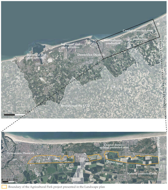
Figure 1.
The case study areas: the Urban Community of Dunkirk and the Agricultural Park project.
The UCD’s local authority implements a variety of public policies to address the issues of the ecological transition in the territory. It aims at promoting biodiversity, protect natural coastal areas, enhance the landscape and built heritage, develop local food supplies, create recreation areas for the residents and tourists, and develop soft mobility networks. These policies concern agriculture and implicitly set out the expectations that farming activities include managing natural areas and landscapes, creating semi-natural areas to ensure ecological continuity, and developing educational areas. To address the issues associated with local food supplies, the UCD developed a food and agricultural policy in 2018 to encourage the development of more sustainable agricultural practices and local short distribution channels. Since 2022, this policy has been implemented through a Territorial Food Project, which is based mainly on the networking of the stakeholders and development of local supply chains. Along with these policies, the UCD performs spatial planning. In 2016 and 2017, it developed its local urban development plan, a regulatory document that imposes rules on any construction or development project in the territory. This document defines the areas intended for agricultural use and regulates the urban development to preserve the agricultural land. After this regulatory approach, the UCD implemented a voluntary spatial planning approach called a Landscape Plan, with the aim of positioning the landscape as a major issue in its planning approaches to enhance the territory’s attraction to the residents and tourists. To this end, the UCD’s managers worked with landscape architects from 2020 to 2022. The Landscape Plan, based on the approach of landscape architects mentioned, aims at designing a projected evolution of the territory’s spatial configurations to combine the issues for the ecological transition supported by the UCD’s public policies. The Landscape Plan is organised into two phases, each described in an illustrated document. The first phase assesses the territory, tracing the history of its landscapes, their values, their weaknesses, and the challenges that they face. The second phase determines the landscape-quality objectives and proposes a spatially explicit and mapped programme of actions over time. To address the issues of the UCD’s food and agricultural policy, the landscape architects proposed creating an Agricultural Park: a 650 ha area located between the natural area of the coastal dunes and the hydraulic infrastructure of the Furnes Canal, which extends 11 km from the edge of Dunkirk in the west to the Belgian border in the east. The landscape architects plan to use the Agricultural Park for market gardening through short distribution channels and present it as a place for both producing food and meeting the needs of the urban residents for recreation and walking areas. This proposal does not take into account the spatial issues of the current farming systems, and local agricultural stakeholders and farmers have not been included in the design of the Agricultural Park by landscape architects.
This case study appeared to have an interesting level of governance and dynamics related to the public spatial planning approaches for projecting the changes in the spatial configurations of a territory for agroecology. We thus used the Agricultural Park project to experiment with certain principles of multi-stakeholder spatial projection as part of an ongoing approach. For the UCD managers involved, this study was a way to advance the Agricultural Park project to identify the approaches and ways to implement it.
3.1.2. Qualitative Analysis of the Data Collected during the Experiment
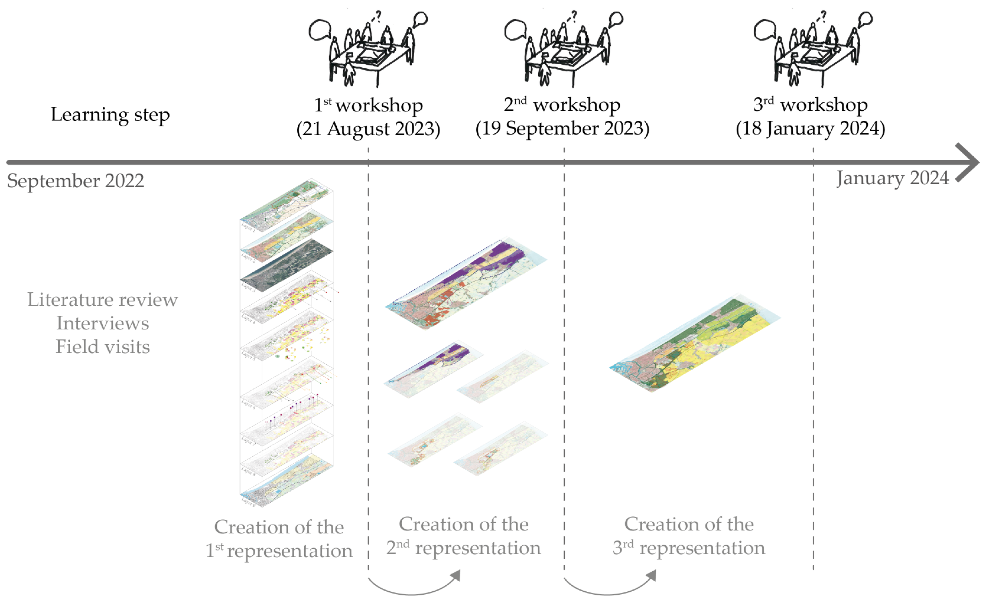
The experiment with multi-stakeholder spatial projection for the UCD began with learning about the territory through two field visits and interviews with the managers of the UCD and the local Chamber of Agriculture. The aim of this step was to better understand the UCD’s specific characteristics to adapt the implementation of multi-stakeholder spatial projection. Next, three collective workshops were held based on the new spatial representations of the territory. Two databases were developed during the experiment. The first contained data from the discussions with stakeholders during interviews and workshops in the form of audio recordings and written reports. The second contained the data from the projection process and the documents produced during its steps, specifically the spatial representations produced to support the three collective workshops and the descriptions of how the process was developed, in the form of logbooks and written intermediate summaries. These two databases were analysed qualitatively [49] to understand how the principles of the multi-stakeholder spatial projection process became part of an ongoing process within a local authority and to discuss the strengths, limitations, and possible future developments of this new framework. The experiment and its results are presented as a chronological narrative (Figure 2).
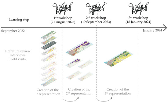
Figure 2.
Timeline of the experiment in the case study of the Urban Community of Dunkirk.
3.2. Results: Implementing the Initial Steps of Multi-Stakeholder Spatial Projection
During the learning step (September 2022 to July 2023), the UCD managers mentioned their lack of knowledge about agriculture, the political tensions between the UCD’s elected representatives and agricultural stakeholders, and their difficulties in implementing actions in agricultural areas. We thus adapted the initial steps of multi-stakeholder spatial projection to the territory’s specific characteristics.
The first collective workshop was intended for managers from the different services in the UCD to share each service’s views of the Agricultural Park project and the questions raised about implementing it. To support these discussions, we developed a new representation of the territory (Figure 3) to add the spatial issues of the farming systems in the Agricultural Park sector to the territorial issues considered in the Landscape Plan. To establish the relationships among these issues, we used a form of axonometric mapping frequently used by landscape architects. Overlapping multiple data layers that are represented in a spatially explicit and place-based way helps one understand the spatial interactions in a territory. The UCD managers also understood this axonometric representation easily, as they often worked with maps of the territory. The aim was to enable them to orient themselves in space by relating the information shared in the workshop to the issues addressed in the UCD’s public policies. To ensure that this representation provided the knowledge of farming systems that the UCD managers could use, we adapted its degree of detail to their degree of knowledge of agronomy. Thus, we chose not to represent the detailed information about each farm but instead the spatial principles related to the main types of farming systems in the Agricultural Park sector.
Figure 3.
Extract from the first step in the representation of the territory used as a basis for the first collective workshop (21 August 2023).
The axonometric representation had nine layers, each showing the boundary of the Agricultural Park as a spatial reference. Layers 4–9 represented the spatial issues of the farming systems in the boundary of the Agricultural Park, taken from an assessment of the Chamber of Agriculture [50] based on surveys of farmers performed from 2015 to 2017. This assessment did not describe the spatial configurations of each farm in detail, but enabled the spatial logic of the types of farming systems to be understood. The nine layers contained the following information:
- -
- Layer 1 represented the environmental, heritage, and recreational issues highlighted in the Landscape Plan.
- -
- Layer 2 was a plan of the Agricultural Park proposed in the Landscape Plan.
- -
- Layer 3 was an aerial photograph of the territory used to provide spatial references in the existing space.
- -
- Layer 4 represented how the fields located within the Agricultural Park boundary are related to the buildings of the farms that cultivated them. These buildings could be located near the cultivated fields or several kilometres away. In the eastern end of the Agricultural Park, occupied by mixed-crop and mixed crop–livestock farms, most buildings were located outside of the Agricultural Park boundary. The changes in these cultivated areas for the Agricultural Park project thus needed to consider places located outside of the boundary.
- -
- Layer 5 represented that the fields within the Agricultural Park boundary were included in the cropping system of the farm that cultivated them and were related to the farm’s other fields. Their role in the system depended on the type of farm, field size, grouping of fields, and proximity to the buildings. The changes in these fields for the Agricultural Park thus influenced the entire system, including the fields outside of the boundary.
- -
- Layer 6 represented how the fields located within the Agricultural Park boundary are involved in the agricultural processing chains and distribution channels, most of which were national or international. The changes in the farming activities towards the short distribution channels would have an influence beyond these fields and require moving away from the existing channels and building new ones.
- -
- Layer 7 represented that not all the fields within the Agricultural Park boundary had the same type of land tenure. The land owned by farmers or subject to long-term rural leases are important for farmers because they represent long-term stability. Fields subject to insecure leases or threatened by urban development can represent a risk for farms and limit farmers’ commitment to new projects. Within the Agricultural Park, the potential to convert the fields may therefore depend on the current land tenure.
- -
- Layer 8 represented that the types of farms within the Agricultural Park boundary had different development trajectories related to the age of the farm manager, recent financial investments, number of employees, or the farmers’ groups to which a farmer belonged. The trajectories may represent the mechanisms for or obstacles to implementing the desired transformations of the Agricultural Park.
- -
- Layer 9 represented that the farming practices interact with the territory’s natural hydraulic and soil resources, and infrastructure (e.g., buildings, roads, paths). These interactions need to be considered to establish new farming activities and assess the impacts of these activities on the natural resources in the Agricultural Park.
The first collective workshop (21 August 2023, 1.75 h, videoconference) involved five UCD managers identified by the managers in charge of implementing the Landscape Plan: a project manager in charge of the quality of life and environment service, the head of the local biodiversity office, a biodiversity and natural space project manager, a food and agricultural policy project manager, and the deputy director of urban planning in charge of the local urban development plan. A landscape architect from the Agence d’Urbanisme Flandre Dunkerque (AGUR), who helped the UCD develop its Landscape Plan, also attended.
We organised this workshop into three stages. The first step enabled the managers to share their understanding of the Agricultural Park project as presented in the Landscape Plan and the actions that they envisioned to implement it. This first stage was based on describing layers 1 and 2 of the axonometric representation, followed by an open discussion. The second stage aimed at presenting the spatial issues of farming systems (layers 4–9) so that the managers could begin to learn them. Afterwards, the managers were given time to react, discuss, and ask questions. The third stage aimed at helping the managers envision which new farming activities could be implemented to meet their local food-supply objectives. To facilitate this projection, we asked questions such as “What types of production would be needed for a balanced diet?”, “What types of farms would be desired?”, “What supply chains would need to be set up?”, and “What would be the most suitable type of land tenure?”. The answers to these questions took the form of an open discussion.
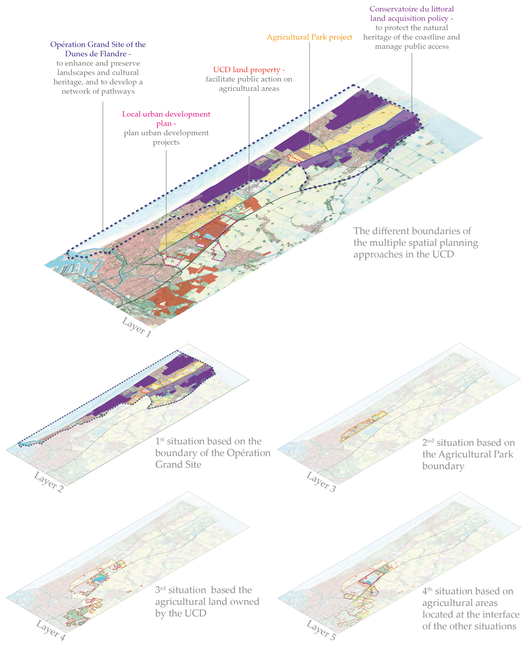
In the UCD experiment, we set up the initial steps of an iterative process. As the three workshops were developed progressively, their content and the axonometric representations used during them were not predefined. The objective was to adapt the steps of the process gradually, depending on the ideas shared during the workshops. The first workshop highlighted the four main observations: (i) the Agricultural Park sector was the subject of several spatial planning approaches besides the Landscape Plan, (ii) the boundary of the Agricultural Park could be questioned, (iii) the managers understood the axonometric representation well, and (iv) the political tensions between the UCD and the Chamber of Agriculture made it impossible to involve institutions other than the UCD and AGUR in the subsequent steps of the experiment. Based on these observations, we built the second workshop, which aimed at enabling the UCD managers to discuss the courses of action that could be envisioned to implement the Agricultural Park project under the existing spatial planning approaches, while including the spatial issues of the farming systems shared during the first workshop. To support these discussions, we produced a second axonometric representation of the territory that illustrated the different boundaries of the multiple spatial planning approaches and related them to the spatial issues of the farming systems (Figure 4). It aimed at enabling the managers to understand the diversity of the situations in the Agricultural Park sector and determine how to adapt their courses of action accordingly.
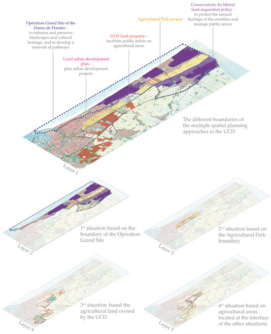
Figure 4.
Extract from the second step in the representation of the territory used as a basis for the second collective workshop (19 September 2023). The different boundaries of the multiple spatial planning approaches in the Urban Community of Dunkirk (UCD), and four distinct situations at the interface of the boundaries of spatial planning approaches and the spatial issues of farming systems.
The second axonometric representation consisted of the existing context (layer 1) and proposed divisions of the territory into four distinct situations (layers 2–5), which we identified at the interface between the boundaries of the spatial planning approaches and the spatial issues of the farming systems. The layers contained the following information:
- -
- Layer 1—The boundaries of the spatial planning approaches mentioned by the managers during the first workshop were overlapped on a map of the territory, which made it possible to identify the areas where several approaches overlapped. This layer highlighted that the spatial planning approaches applied to a variety of agricultural areas.
- -
- Layer 2—The first situation was based on the boundary of the Opération Grand Site of the Dunes de Flandre, which included that of the Conservatoire du littoral’s (i.e., coastal protection agency’s) land-acquisition policy and the eastern part of the Agricultural Park boundary. This boundary defined a situation in which the preservation of natural areas, ecological network, and landscape enhancement and the development of walking areas applied to the agricultural areas cultivated by mixed-crop and mixed crop–livestock farms. In this situation, the absence of public land in agricultural areas limited the UCD’s courses of action.
- -
- Layer 3—The second situation was based on the western part of the Agricultural Park boundary and was not influenced by the boundaries of the other spatial planning approaches. This boundary defined a situation in which the establishment of market gardening systems for local food supplies and the development of recreation and walking areas applied to the agricultural areas cultivated mainly by horticultural systems. In this situation, the absence of public land in the agricultural areas also limited the UCD’s courses of action.
- -
- Layer 4—The third situation was based on the boundary defined by the agricultural land owned by the UCD and was not influenced by the boundaries of the other spatial planning approaches. This boundary defined a situation in which the UCD could use the public nature of the land to implement mechanisms such as environmental rural leases or the establishment of farmers who met the predefined specifications. This situation applied to the agricultural areas cultivated mainly by mixed-crop farms near the urban areas or nature and recreation areas.
- -
- Layer 5—The fourth situation was based on the agricultural areas located at the interface of the boundaries of the Agricultural Park, agricultural land owned by the UCD, and urban development projects of the local urban development plan. This situation applied to the fragmented agricultural areas, mainly mixed-crop farms subjected to urban pressure.
The second collective workshop (19 September 2023, 2 h, videoconference) involved the five UCD managers who attended the first workshop, and two additional managers invited by the managers in charge of implementing the Landscape Plan, namely the head of the land service and a land-strategy officer in order to benefit from their expertise regarding land property and land regulation tools. The landscape architect from the AGUR who attended the first workshop also attended the second workshop, accompanied by another AGUR landscape architect in charge of the Opération Grand Site of the Dunes de Flandre already invited to the first workshop. After a brief introduction to summarise the discussions of the first workshop, we presented the second axonometric representation and shared with the managers the four situations which we identified. Discussions then took place in two stages: the participants first shared their reactions spontaneously, and then the group focused on which initial actions to implement to move towards the Agricultural Park project.
The third workshop was based on the three main observations that the managers had highlighted during the second workshop: (i) the local urban development plan imposes construction rules on fields that need to be considered in the development of the agricultural areas; (ii) the UCD was already involved in projects on or near the agricultural areas that could serve as an entry point in implementing the Agricultural Park; and (iii) because the UCD managers are limited in their actions until projects are approved politically, they need dedicated meetings to discuss projects with the UCD’s elected representatives. Thus, the third workshop was designed to provide an opportunity for the managers and elected representatives of the UCD to discuss the Agricultural Park project and share the ideas discussed during the first two workshops. To support these discussions, we produced a third axonometric representation of the territory (with only one layer). This third representation showed additional regulatory elements for non-building areas from the local urban development plan, and located the projects being performed by the UCD and AGUR on public land (Figure 5).
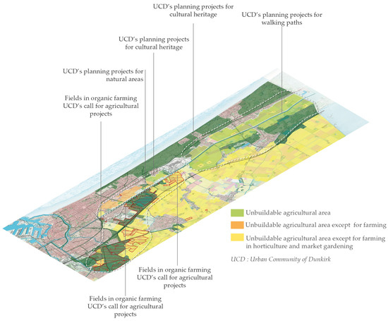
Figure 5.
Extract from the third step in the representation of the territory used as a basis for the third collective workshop (18 January 2024).
The third collective workshop (18 January 2024, 1.5 h, in person in Dunkirk) involved five UCD managers who attended the first and/or second workshop, the two AGUR landscape architects who attended the second workshop, and the director of the quality of life and environment service in charge of the Landscape Plan, already invited to the previous workshops. The managers had invited four elected representatives of the UCD to this workshop, but only one, the councillor in charge of agriculture and local produce, was able to attend, due to scheduling constraints. By involving them, the managers aimed to obtain their political approval to implement new actions.
We organised this discussion in four stages. First, the managers introduced the workshop to the representative. We then introduced the research approach and presented the three axonometric representations. The representative was given time to react freely, expressing comments and questions about the information in the representations. The managers and representative then discussed how they could continue this process to implement the Agricultural Park. The workshop concluded with discussions among the managers. They affirmed that they wanted to take advantage of the dynamics generated by the workshops to continue the discussions among the multiple UCD services and between them and the elected representatives, create relationships among the spatial planning approaches, and work towards changes in the agricultural areas in the Agricultural Park sector.
4. Discussion
This case study shows that multi-stakeholder spatial projection made it possible to build the initial steps of an adapted approach integrated into the dynamics of the Landscape Plan and the Agricultural Park project. Implementing these initial steps enabled the UCD managers to consider changes in the location and the size of the Agricultural Park to better include the spatial issues of the farming systems. These first changes indicated that, if the experiment had been implemented over a longer period, the projection in new spatial configurations of the territory could have been continued and could have led to more precise proposals, for example about the farming systems developed in the Agricultural Park or about the spatial configuration of the agricultural areas in the Agricultural Park.
To test the first principle of multi-stakeholder spatial projection, the method highlighted the spatial issues of the farming systems in the Agricultural Park sector and related them to the territorial issues considered in the Landscape Plan, using axonometric mapping. The agricultural spatial issues considered included the multiple spatial sectors of agricultural production, the influence of the distance between the fields and farm buildings, the roles of the fields in the farming system as a function of the spatial configuration of all the fields, the relationships between the production places and processing or distribution places in the agricultural sector, the influence of the type of land tenure on the farmers’ choices, the relationship between the farm dynamics and the potential change in spatial configurations, and the influence of the spatial configurations of the infrastructure and access to natural resources on the farming practices. These spatial issues for the existing farming systems could be considered due to a detailed assessment performed by the Chamber of Agriculture in 2017. To implement the first principle of multi-stakeholder spatial projection, it is necessary to have detailed information on the spatial issues of the farming systems or to acquire it from agricultural advisors or farmers.
The political tensions between the UCD and local Chamber of Agriculture prevented us from implementing the second principle of multi-stakeholder spatial projection. As the UCD managers did not have political approval from their elected representatives, they did not want us to involve the managers from agricultural institutions in the collective workshops. However, due to our knowledge of agronomy, an interview with an agent from the Chamber of Agriculture, and available information on the agricultural systems of the territory, agricultural knowledge could be included in the discussions. This knowledge was shared with the UCD managers using the axonometric representation used by landscape architects. Using this form of representation, along with adapting the detail of the agricultural information to the managers’ agronomic knowledge, enabled the UCD managers to enhance their knowledge and to relate it to the non-agricultural issues of the territory. This new knowledge led the managers to identify the need to discuss the implementation of the Agricultural Park project with agricultural organisations and farmers. This case study highlights the importance of considering the political issues and relationships among the local stakeholder groups to adapt the application of multi-stakeholder spatial projection to a territory’s specific characteristics.
For the duration of the experiment (15 months), the third principle of multi-stakeholder spatial projection was tested by implementing three progressive steps of representation and discussion. To gradually build a representation that includes the spatial issues of farming systems and territorial issues of local authorities for ecological transition, the content of these three steps was not determined at the beginning of the process, but was adapted gradually as the UCD managers learned agricultural knowledge and discussed ideas during the workshops. The experiment was too short to set up a long-term, iterative process that considered the dynamics and uncertainties of the farming systems. However, these initial steps did demonstrate the ability to implement an adaptable method and enabled the managers to identify the need to develop courses of action over the long term that considered the farm dynamics. These initial steps highlight the importance of implementing this process over a longer period.
In the case study, the methodological framework was experimented with in a per-urban context. The high pressure for the use of space in this territory leads the UCD’s local authority to be highly concerned about agricultural areas with many expectations about the agricultural activities. One of the characteristics of the methodological framework is to be adapted to the specific characteristics of each territory. We think that it can also be used in rural territory provided that the territory presents an interweaving of agricultural and non-agricultural issues requiring multifunctional agricultural areas, and thus concerns a diversity of agricultural and non-agricultural stakeholders. We assume that the implementation of the process can be facilitated when the stakeholders are highly involved in the territorial issues, for example if they have to find the solutions to environmental problems. It seems to us that the method can be used easily in European rural territories, which often contain diverse agricultural areas with a variety of uses. The framework needs to be tested, for example in the United States or Canada, to see if it can be adapted to territories with vast areas dedicated to agricultural production.
With the UCD case study, we experimented with applying multi-stakeholder spatial projection to a level of governance related to a local authority and in the dynamics related to the public spatial planning approaches. This context enabled us to develop the initial steps of the process and to identify the interest of the UCD managers in the agroecological transition to respond to the multiple issues of the territory. This experiment also enabled us to identify that, despite the UCD’s many expectations about agricultural activities, its spatial planning approaches did not consider the spatial issues of the farming systems, which risks projecting spatial configurations of the territory that are not suitable for agroecology. The collective workshops highlighted, for example, the inconsistency between the boundary of the Agricultural Park and the spatial issues of the existing farming systems or of the market gardening systems envisioned in the project, or the overlapping of the sometimes contradictory expectations about agricultural areas.
Beyond the methodological framework, these observations raise questions about the right levels of governance. Although the local authorities in France appear to be key stakeholders in the evolution of territories, these limitations show that they may not be the most suitable level of governance for designing and implementing the new spatial configurations for agroecology. New levels of governance that combine the local authorities and agricultural institutions could be envisioned to address these spatial issues at the territorial scale. More generally, the need to address the spatial configurations for agroecology at the territorial scale implies finding the appropriate level of governance and appropriate design approaches. The principles of multi-stakeholder spatial projection could thus be tested in other countries with levels of governance that can support the implementation of new spatial configurations at the territorial scale in rural areas (e.g., [46,51]).
5. Conclusions
To co-design and implement the new spatial configurations for agroecology, we developed a new methodological framework at the interface between landscape architecture and landscape agronomy. We experimented with the principles of multi-stakeholder spatial projection with local public authorities in France, whose actions and projects concern the issue of agriculture at the territorial scale. These principles provide guidelines for designing new approaches to design and implement new spatial configurations for agroecology, considering the expectations about the multifunctionality of agroecological systems for multiple stakeholders. Experiments must continue in order to refine this framework and develop approaches adapted to the different situations in France and other countries with spatial planning in rural areas. We believe that these objectives cannot be achieved exclusively on a theoretical basis in research institutes, but require experimentation in practice with the local stakeholders. Experimentation contributes to agroecology research to develop the knowledge about the spatial configurations suitable for agroecology. For research in land management, this study contributes to providing knowledge about how to include agriculture in spatial planning.
Author Contributions
Conceptualization, A.C., V.V. and L.V.; writing—original draft, A.C.; writing—review and editing, A.C., V.V. and L.V. All authors have read and agreed to the published version of the manuscript.
Funding
This research was funded by the French Ministry of Research, grant number CIFRE n° 2021/0889 and INRAE. The APC was funded by INRAE.
Data Availability Statement
The original contributions presented in the study are included in the article, further inquiries can be directed to the corresponding author.
Acknowledgments
The Ph.D. thesis of Amélie Cénet is funded by a CIFRE (French Ministry of Research) research agreement with the landscape architects agency, Folléa-Gautier. The authors thank Michelle and Michael Corson for proofreading this paper.
Conflicts of Interest
The authors declare no conflicts of interest. The funders had no role in the design of the study; in the collection, analyses, or interpretation of data; in the writing of the manuscript; or in the decision to publish the results.
References
- Altieri, M.A.; Nicholls, C.I.; Montalba, R. Technological Approaches to Sustainable Agriculture at a Crossroads: An Agroecological Perspective. Sustainability 2017, 9, 13. [Google Scholar] [CrossRef]
- Cairol, D.; Coudel, E.; Knickel, K.; Caron, P.; Kröger, M. Multifunctionality of Agriculture and Rural Areas as Reflected in Policies: The Importance and Relevance of the Territorial View. J. Environ. Policy Plan. 2009, 11, 269–289. [Google Scholar] [CrossRef]
- Duru, M.; Fares, M.H.; Therond, O. A conceptual framework for thinking now (and organising tomorrow) the agroecological transition at the level of the territory. Cah. Agric. 2014, 23, 84–95. [Google Scholar] [CrossRef]
- Landis, D.A. Designing agricultural landscapes for biodiversity-based ecosystem services. Basic Appl. Ecol. 2017, 18, 1–12. [Google Scholar] [CrossRef]
- Smithwick, E.A.H.; Baka, J.; Bird, D.; Blaszscak-Boxe, C.; Cole, C.A.; Fuentes, J.D.; Gergel, S.E.; Glenna, L.L.; Grady, C.; Hunt, C.A.; et al. Regenerative landscape design: An integrative framework to enhance sustainability planning. Ecol. Soc. 2023, 28, 5. [Google Scholar] [CrossRef]
- Worosz, M.R. Transdisciplinary research for wicked problems. Agric. Hum. Values 2022, 39, 1185–1189. [Google Scholar] [CrossRef]
- Girard, N.; Magda, D. Les jeux entre singularité et généricité des savoirs agro-écologiques dans un réseau d’éleveurs. Rev. D’anthropologie Des Connaiss. 2018, 12, 199–228. [Google Scholar] [CrossRef]
- Pignal, A.C.; Lucas, V.; Boulet, A.; Blondel, L.; Gasselin, P.; Cittadini, R. CAP VERT—Comprendre, vivre et accompagner la transition agroécologique en collectif. Innov. Agron. 2019, 71, 165–180. [Google Scholar] [CrossRef]
- Valorge, F.; Lucas, V.; Pavie, J.; Casagrande, M.; Garcia-Velasco, A. LUZ’CO—Collective solutions to develop forage legumes LUZ’CO—Solutions collectives pour développer les légumineuses fourragères. Innov. Agron. 2021, 82, 191–204. [Google Scholar] [CrossRef]
- Gascuel-Odoux, C.; Magda, D. Gérer les paysages et les territoires pour la transition agroécologique. Innov. Agron. 2015, 43, 95–106. [Google Scholar]
- Direction Generale Collectivité Locales. Compétences-Aménager mon Territoire. Available online: https://www.collectivites-locales.gouv.fr/competences# (accessed on 9 August 2024).
- Torre, A.; Wallet, F.; Huang, J. Le foncier agricole, nouvel enjeu des politiques d’aménagement de l’espace. Économie Rural. 2023, 383, 7–13. [Google Scholar] [CrossRef]
- De Briant, V. Collectivités territoriales et environnement—2022. Rev. Jurid. De L’environ. 2023, 48, 661–673. [Google Scholar]
- Zasada, I. Multifunctional peri-urban agriculture—A review of societal demands and the provision of goods and services by farming. Land Use Policy 2011, 28, 639–648. [Google Scholar] [CrossRef]
- Benoît, M.; Rizzo, D.; Marraccini, E.; Moonen, A.C.; Galli, M.; Lardon, S.; Rapey, H.; Thenail, C.; Bonari, E. Landscape agronomy: A new field for addressing agricultural landscape dynamics. Landsc. Ecol. 2012, 27, 1385–1394. [Google Scholar] [CrossRef]
- Rizzo, D.; Marraccini, E.; Lardon, S.; Rapey, H.; Debolini, M.; Benoit, M.; Thenail, C. Farming systems designing landscapes: Land management units at the interface between agronomy and geography. Geogr. Tidsskr. 2013, 113, 71–86. [Google Scholar] [CrossRef]
- Thenail, C.; Joannon, A.; Capitaine, M.; Souchère, V.; Mignolet, C.; Schermann, N.; Di Pietro, F.; Pons, Y.; Gaucherel, C.; Viaud, V.; et al. The contribution of crop-rotation organization in farms to crop-mosaic patterning at local landscape scales. Agric. Ecosyst. Environ. 2009, 131, 207–219. [Google Scholar] [CrossRef]
- Thenail, C. Relationships between farm characteristics and the variation of the density of hedgerows at the level of a micro-region of bocage landscape. Study case in Brittany, France. Agric. Syst. 2002, 71, 207–230. [Google Scholar] [CrossRef]
- Baudry, J.; Thenail, C. Interaction between farming systems, riparian zones, and landscape patterns: A case study in western France. Landsc. Urban Plan. 2004, 67, 121–129. [Google Scholar] [CrossRef]
- Latruffe, L.; Piet, L. Does land fragmentation affect farm performance? A case study from Brittany, France. Agric. Syst. 2014, 129, 68–80. [Google Scholar] [CrossRef]
- Levin, G.; Nainggolan, D. The significance of spatial fragmentation of land ownership for occurrence of scrubs on semi-natural grasslands. Landsc. Ecol. 2016, 31, 2031–2044. [Google Scholar] [CrossRef]
- Asai, M.; Moraine, M.; Ryschawy, J.; de Wit, J.; Hoshide, A.K.; Martin, G. Critical factors for crop-livestock integration beyond the farm level: A cross-analysis of worldwide case studies. Land Use Pol. 2018, 73, 184–194. [Google Scholar] [CrossRef]
- Debolini, M.; Schoorl, J.M.; Temme, A.; Galli, M.; Bonari, E. Changes in Agricultural Land Use Affecting Future Soil Redistribution Patterns: A Case Study in Southern Tuscany (Italy). Land Degrad. Dev. 2015, 26, 574–586. [Google Scholar] [CrossRef]
- Barbottin, A.; Bouty, C.; Martin, P. Using the French LPIS database to highlight farm area dynamics: The case study of the Niort Plain. Land Use Pol. 2018, 73, 281–289. [Google Scholar] [CrossRef]
- Petit, S.; Muneret, L.; Carbonne, B.; Hannachi, M.; Ricci, B.; Rusch, A.; Lavigne, C. Chapter One—Landscape-scale expansion of agroecology to enhance natural pest control: A systematic review. In Advances in Ecological Research; Bohan, D.A., Vanbergen, A.J., Eds.; Academic Press: Dijon, France, 2020; Volume 63, pp. 1–48. [Google Scholar]
- Moreira, E.F.; Boscolo, D.; Viana, B.F. Spatial heterogeneity regulates plant-pollinator networks across multiple landscape scales. PLoS ONE 2015, 10, e0123628. [Google Scholar] [CrossRef]
- Ricci, B.; Petit, S.; Allanic, C.; Langot, M.; Parisey, N.; Poggi, S. How effective is large landscape-scale planning for reducing local weed infestations? A landscape-scale modelling approach. Ecol. Model. 2018, 384, 221–232. [Google Scholar] [CrossRef]
- Murgue, C.; Therond, O.; Leenhardt, D. Toward integrated water and agricultural land management: Participatory design of agricultural landscapes. Land Use Pol. 2015, 45, 52–63. [Google Scholar] [CrossRef]
- Casal, L.; Durand, P.; Akkal-Corfini, N.; Benhamou, C.; Laurent, F.; Salmon-Monviola, J.; Ferrant, S.; Probst, A.; Probst, J.-L.; Vertès, F. Reduction of stream nitrate concentrations by land management in contrasted landscapes. Nutr. Cycl. Agroecosystems 2019, 114, 1–17. [Google Scholar] [CrossRef]
- Puech, T.; Schott, C.; Mignolet, C. Characterising the diversity and spatial differentiation of crop managements at a regional scale. Eur. J. Agron. 2020, 120, 126112. [Google Scholar] [CrossRef]
- Viaud, V.; Angers, D.A.; Walter, C. Toward Landscape-Scale Modeling of Soil Organic Matter Dynamics in Agroecosystems. Soil Sci. Soc. Am. J. 2010, 74, 1847–1860. [Google Scholar] [CrossRef]
- Klein, T.; Holzkämper, A.; Calanca, P.; Seppelt, R.; Fuhrer, J. Adapting agricultural land management to climate change: A regional multi-objective optimization approach. Landsc. Ecol. 2013, 28, 2029–2047. [Google Scholar] [CrossRef]
- Jeanneret, P.; Aviron, S.; Alignier, A.; Lavigne, C.; Helfenstein, J.; Herzog, F.; Kay, S.; Petit, S. Agroecology landscapes. Landsc. Ecol. 2021, 36, 2235–2257. [Google Scholar] [CrossRef] [PubMed]
- Boesing, A.L.; Klaus, V.H.; Neyret, M.; Le Provost, G.; Peter, S.; Fischer, M.; Manning, P. Identifying the optimal landscape configuration for landscape multifunctionality. Ecosyst. Serv. 2024, 67, 101630. [Google Scholar] [CrossRef]
- Thenail, C.; Moonen, A.-C.; Lardon, S.; Marraccini, E.; Rizzo, D. Landscape Agronomy: Lessons Learned and Challenges Ahead, from a European Perspective. In Landscape Agronomy: Advances and Challenges of a Territorial Approach to Agricultural Issues; Rizzo, D., Marraccini, E., Lardon, S., Eds.; Springer International Publishing: Cham, Switzerland, 2022; pp. 271–294. [Google Scholar]
- Follea, B.; Gomel, C.; Parrouffe, J.-M.; Richard, N.; Schmid, L.; Thibault, J.-P. Réussir la Transition Écologique par L’approche Paysagère; La Fabrique Écologique: Paris, France, 2024; Available online: https://www.lafabriqueecologique.fr/reussir-la-transition-ecologique-par-lapproche-paysagere-2/ (accessed on 16 October 2024).
- MTE, M.d.l.t.é. Objectif Paysages. Available online: www.objectif-paysages.developpement-durable.gouv.fr (accessed on 22 December 2023).
- Council of Europe. European Landscape Convention 2000; Eds Council of Europe, European Treaty Series no.176. Available online: https://rm.coe.int/16807b6bc7 (accessed on 16 October 2024).
- Bonin, S.; Follea, B. Projet de paysage, projet agricole et design territorial. Agron. Environ. Société 2018, 8, 31–40. [Google Scholar]
- Voisin, L.; Cénet, A.; Génuite, I.; Viaud, V. Ouvrir le champ des possibles. Comment les pratiques paysagistes entrent en agriculture? Proj. Paysage 2024, 30. [Google Scholar] [CrossRef]
- Tress, B.; Tress, G.; Décamps, H.; d’Hauteserre, A.-M. Bridging human and natural sciences in landscape research. Landsc. Urban Plan. 2001, 57, 137–141. [Google Scholar] [CrossRef]
- Sayer, J.; Sunderland, T.; Ghazoul, J.; Pfund, J.L.; Sheil, D.; Meijaard, E.; Venter, M.; Boedhihartono, A.K.; Day, M.; Garcia, C.; et al. Ten principles for a landscape approach to reconciling agriculture, conservation, and other competing land uses. Proc. Natl. Acad. Sci. USA 2013, 110, 8349–8356. [Google Scholar] [CrossRef]
- Pereponova, A.; Grahmann, K.; Lischeid, G.; Bellingrath-Kimura, S.D.; Ewert, F.A. Sustainable transformation of agriculture requires landscape experiments. Heliyon 2023, 9, e21215. [Google Scholar] [CrossRef]
- Pinto-Correia, T.; Kristensen, L. Linking research to practice: The landscape as the basis for integrating social and ecological perspectives of the rural. Landsc. Urban Plan. 2013, 120, 248–256. [Google Scholar] [CrossRef]
- Kristensen, L.S.; Primdahl, J. Landscape strategy making as a pathway to policy integration and involvement of stakeholders: Examples from a Danish action research programme. J. Environ. Plan. Manag. 2019, 63, 1114–1131. [Google Scholar] [CrossRef]
- Primdahl, J.; Folvig, S.; Kristensen, L.S. Landscape Strategy-Making and Collaboration. The Hills of Northern Mors, Denmark; A Case of Changing Focus and Scale. Land 2020, 9, 189. [Google Scholar] [CrossRef]
- Primdahl, J.; Kristensen, L.S.; Swaffield, S. Guiding rural landscape change. Appl. Geogr. 2013, 42, 86–94. [Google Scholar] [CrossRef]
- Kristensen, L.S.; Pears, D.Q.; Primdahl, J. Guiding Multifunctional Landscape Changes Through Collaboration: Experiences from a Danish Case Study. In Landscape Agronomy: Advances and Challenges of a Territorial Approach to Agricultural Issues; Rizzo, D., Marraccini, E., Lardon, S., Eds.; Springer International Publishing: Cham, Switzerland, 2022; pp. 247–270. [Google Scholar]
- Pernet, A. Le Grand Paysage en Projet. Histoire, Critique et Expérience; Metis Presses: Geneva, Switzerland, 2014. [Google Scholar]
- Chambre Agriculture. L’agriculture sur le Territoire de la Communauté Urbaine de Dunkerque; Chambre d’agriculture du Nord-Pas de Calais: Saint-Laurent-Blangy, France, 2017. [Google Scholar]
- Baumgarten, S.; Aarts, N.; Fliervoet, J.M.; Krabbenborg, L. Dynamics and Dependencies in Regional Collaboration for Biodiversity Restoration: Reflections from The Netherlands. Environ. Manag. 2024. [Google Scholar] [CrossRef] [PubMed]

Disclaimer/Publisher’s Note: The statements, opinions and data contained in all publications are solely those of the individual author(s) and contributor(s) and not of MDPI and/or the editor(s). MDPI and/or the editor(s) disclaim responsibility for any injury to people or property resulting from any ideas, methods, instructions or products referred to in the content. |
© 2024 by the authors. Licensee MDPI, Basel, Switzerland. This article is an open access article distributed under the terms and conditions of the Creative Commons Attribution (CC BY) license (https://creativecommons.org/licenses/by/4.0/).