Article

Multidimensional Assessment of the Aesthetic Quality of Natural Landscapes in Mount Wuyi National Park, China

1
Key Laboratory of Regional Sustainable Development Modeling, Institute of Geographic Sciences and Natural Resources Research, Chinese Academy of Sciences, Beijing 100101, China
2
College of Resources and Environment, University of Chinese Academy of Sciences, Beijing 100049, China
3
State Key Laboratory of Desert and Oasis Ecology, Xinjiang Institute of Ecology and Geography, Chinese Academy of Sciences, Urumqi 830011, China
4
School of Tourism, Henan Normal University, Xinxiang 453007, China
*
Author to whom correspondence should be addressed.
Land 2024, 13(10), 1674; https://doi.org/10.3390/land13101674
Submission received: 9 September 2024 / Revised: 12 October 2024 / Accepted: 13 October 2024 / Published: 14 October 2024
(This article belongs to the Section Land Planning and Landscape Architecture)

Abstract

:
Natural landscapes are scenic complexes accessible to the public within national parks. Exploring their aesthetic quality can promote an emotional connection between the public and the landscape, which has a positive significance in enhancing human well-being. In this study, Mount Wuyi National Park in China was considered as the study area, and key dimensions tailored to individual and combined natural landscapes for aesthetic quality evaluation were proposed. Seventeen landscape metrics were selected to comprehensively measure the aesthetic quality level of the natural landscapes within the study area. The results indicated that (1) the spatial distribution of 341 individual natural landscapes exhibited a pattern of denser concentration in the south and east, with a relatively sparse distribution in the north and west. (2) Based on the elements of land cover, vegetation, topography, and landforms, 41 types of combined natural landscapes were identified in Mount Wuyi National Park. (3) Southeastern natural landscapes possess significant advantages in aesthetic service provision, uniqueness, diversity, combination, and coordination, and are concentrated in natural landscapes of high aesthetic quality. Natural landscapes of moderate aesthetic quality were distributed across the northern, southwestern, and some parts of the southeastern areas within the study region. The findings provide a reference for aesthetic quality assessment in natural landscapes at the micro-scale and serve as a basis for the scientific management of natural landscapes in national parks.

1. Introduction

Natural landscapes, which serve as scenic complexes directly accessible to the public within national parks, constitute a vital medium for fostering emotional connections between the public and these national parks [1]. Distinct from the traditional Chinese nature reserve system, which focuses on the stringent protection of ecosystems and natural resources [2], the Chinese national park system integrates multiple objectives of resource conservation and sustainable development [3]. Cultural ecosystem services provided by natural landscapes, such as aesthetics, recreation, and natural education, serve as crucial underpinnings for national parks to fulfill their public welfare objectives and enhance human well-being [4,5,6]. Consequently, against the backdrop of increasingly close human–landscape transactions [7,8], the exploration of the aesthetic value of natural landscapes in national parks holds positive implications for promoting the conservation of natural landscape resources and fostering the harmonious coupling of dynamic relationships between humans and landscapes.
The aesthetic quality of landscapes is highly dependent on their visual characteristics [9]. Tveit et al. delineated nine principal elements of landscape visual characteristics: stewardship, coherence, disturbance, historicity, visual scale, imageability, complexity, naturalness, and ephemera [10]. Based on the principles of transferability, quantifiability, cartographic representation, relevance, and data availability in landscape aesthetic assessment [11], Hermes et al. distilled these elements into diversity, naturalness, and uniqueness [12]. Afterwards, they conducted an evaluation and spatial mapping of landscape aesthetic quality in Germany. Subsequently, this framework has been extensively applied in studies assessing the aesthetic quality of landscapes at the macro-scale or meso-scale, encompassing national [13] and regional [14,15] levels. Micro-scale studies often employ psychophysical or psychological models to evaluate landscape aesthetic quality, utilizing methods such as Scenic Beauty Estimation (SBE) [16], Public Participation Geographic Information System (PPGIS) [15], Semantic Differential techniques [17], and eye-tracking methods [18]. These approaches primarily focus on synthesizing judgments of landscape aesthetic quality through observers’ emotional cognitions or preferences.
Previous research has shown that landscape aesthetic assessments conducted at the macro-scale and meso-scale primarily analyze the composition, pattern, and characteristics of the landscape itself [13,19], whereas at the micro-scale, assessments predominantly adopt a human perceptual perspective [9]. Considering the challenges in data acquisition and the difficulty in quantifying indicators, previous micro-scale studies have often overlooked the impact of the intrinsic attributes of landscapes on aesthetic quality. Meanwhile, the existing indicators for evaluating the aesthetic quality of landscapes at the macro-scale or meso-scale are inadequate for capturing the uniqueness of micro-scale landscapes, failing to meet the detailed characterization required for the diversity and richness of landscapes at this scale. Nevertheless, as geographical spaces harbor natural landscapes of national representativeness and significance, national parks necessitate a quantitative assessment of landscape aesthetic quality based on the objective characteristics of the landscapes. Such an evaluation is a crucial complement to existing research on the aesthetic quality assessment of landscapes at a micro-scale level.
This study delves into the profound connotations of natural landscapes in national parks as comprehensive scenic complexes, taking Mount Wuyi National Park, one of China’s first national parks, as a case study area. The aesthetic quality of the natural landscapes in the research area was comprehensively measured from multiple dimensions, including uniqueness, landscape aesthetic services, diversity, combinability, coordination, and visual scales. The specific objectives were to: (1) identify and delineate the spatial layouts of individual and combined natural landscapes; (2) construct key dimensions that adaptively correspond to the aesthetic qualities of individual and combined natural landscapes; and (3) analyze the spatial distribution characteristics of the aesthetic qualities of individual and combined natural landscapes. Subsequently, a comprehensive assessment of the aesthetic quality of the natural landscapes in Mount Wuyi National Park was conducted. This study provides a scientific reference for a high-quality evaluation of the landscape aesthetic quality of national parks. It has positive implications for the exploration of harmonious development in the interactive relationship between humans and landscapes.

2. Research Framework and Methods

2.1. Research Framework: Key Dimensions of Aesthetic Quality in Natural Landscapes
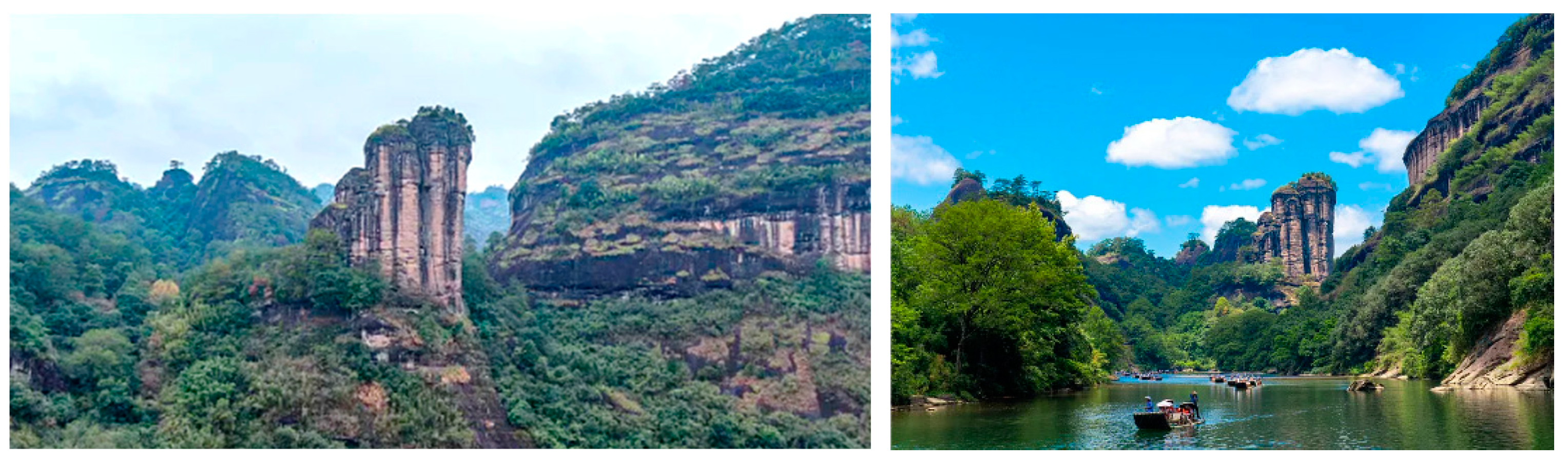
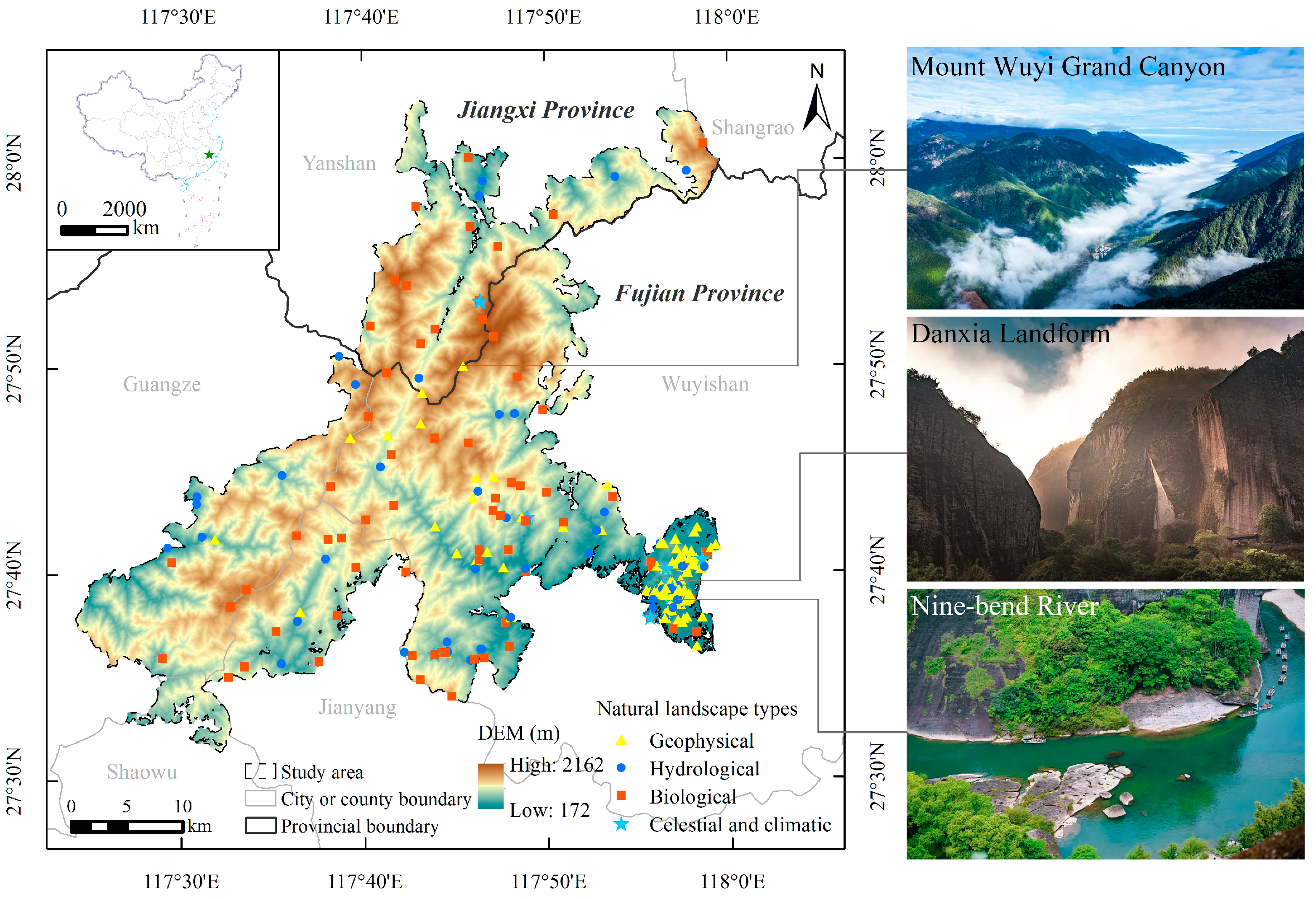
The three dimensions of landscape aesthetic quality (naturalness, diversity, and uniqueness), as summarized by Hermes et al. [12] based on Tveit et al. [10], are representative of macro-scale and meso-scale studies. Furthermore, in the study of the aesthetic quality of landscapes at the micro-scale, the potential for continuous refinement and optimization remains in the selection of indicators. In the realm of human–landscape interaction [7], the uniqueness of natural landscapes, their spatial abundance and variety, the integrated features and coordination level of natural landscape resources, and the aesthetic benefits that natural landscapes offer to humans all influence the aesthetic quality of natural landscapes and the aesthetic experience they bring to people. In addition, the visual scale plays an important role in the human perception of landscape aesthetics and can impact the aesthetic quality of landscapes. Therefore, this study selected landscape aesthetic services, uniqueness, combination, diversity, coordination, and visual scale as the key dimensions for evaluating the micro-scale landscape aesthetic quality (Table 1). This study did not incorporate landscape diversity over time scales into our research scope, as Mount Wuyi National Park experiences a consistently warm and humid climate with seasonal variations exerting a minimal impact on the natural landscape.
Unlike previous studies that separately evaluated individual landscape resources or geographical entities (combined landscapes) [20], this study integrated the aesthetic quality assessment of both individual natural landscapes and combined natural landscapes by considering various spatial organization patterns. Individual natural landscapes refer to individual entities of the basic types of natural landscapes that can be independently appreciated or utilized [21], possessing diverse functions, such as aesthetic appreciation, recreational activities, and natural education. Combined natural landscapes constitute a collection of individual natural landscapes with multiple functions inherent to these individual elements. Moreover, compared to individual natural landscapes, combined natural landscapes can further enhance the aesthetic quality of the landscape [22]. For instance, compared to the individual natural landscape resources of Yunv Peak within Mount Wuyi National Park, the combination of Yunv Peak, the Nine-Bend River, and the surrounding Danxia landform (Figure 1) exhibits a higher aesthetic quality and visual appeal. Consequently, this study selected key dimensions of aesthetic quality adapted to individual and combined natural landscape characteristics for investigation. For example, the ‘combination’ dimension typically refers to the potential for the integration of the same or different types of individual landscapes within a certain area; regions with higher levels of combinability generally exhibit higher aesthetic quality [23]. The ‘coordination’ dimension is typically assessed through the coherence of landscape structure at the patch level and the degree of disturbance, rendering it more applicable to the combined natural landscapes.

2.2. Study Area

Mount Wuyi National Park, one of the first national parks in China, is located on the border of Fujian Province and Jiangxi Province (Figure 2). This study selected Mount Wuyi National Park for aesthetic quality assessment of natural landscapes due to two primary reasons: Firstly, the national park boasts nationally and globally unique natural landscapes. The unique Danxia landform landscapes and river landscapes within Mount Wuyi National Park, such as the Nine-Bend River, along with their collectively formed “Azure Waters and Crimson Peaks” composite landscape, exhibit aesthetic significance of global importance, meeting Criterion vii of the World Heritage Site selection criteria. Secondly, among the initial batch of five national parks in China, the other national parks focus more on significant species (e.g., Amur tiger and leopard, giant panda), as well as vulnerable and typical ecosystems (e.g., alpine ecosystems, tropical rainforests). In comparison, Mount Wuyi National Park stands out for its exceptional representativeness and abundance of natural landscapes, which are more diverse and unique than the other national parks. The study area is characterized by significant natural landscape resources and a diverse range of natural landscape types, including physiographic, hydrological, biological, and astronomical and climatic landscapes. Mount Wuyi National Park boasts high-quality natural landscapes, such as Mount Wuyi Grand Canyon, Nine-Bend River and Yunv Peak.

2.3. Dataset and Pre-Processing

Vector data, including the boundary, land cover, vegetation, and roads of Mount Wuyi National Park, were obtained from the Mount Wuyi National Park Administration. The vector boundary data of administrative regions, such as Fujian and Jiangxi, were sourced from the standard map service website of the Ministry of Natural Resources (http://bzdt.ch.mnr.gov.cn/, accessed on 16 April 2024). Terrain data were obtained from the Resource and Environment Data Cloud Platform (https://www.resdc.cn/, accessed on 16 April 2024). Geomorphological data were sourced from the GeoCloud data service platform provided by the China Geological Survey (https://geocloud.cgs.gov.cn/, accessed on 16 April 2024), where JPG format files of the geomorphological types for Fujian Province and Jiangxi Province were acquired. The geomorphic vector data were then digitized using ArcGIS 10.6 software, combining spatial registration and visual interpretation methods. The POI data for individual natural landscape resources were derived from field surveys, remote sensing imagery, and the ‘Ecological Recreation Special Plan for Mount Wuyi National Park’ planning document. Finally, 341 individual natural landscape resource points were vectorized using ArcGIS 10.6 software.

2.4. Methods

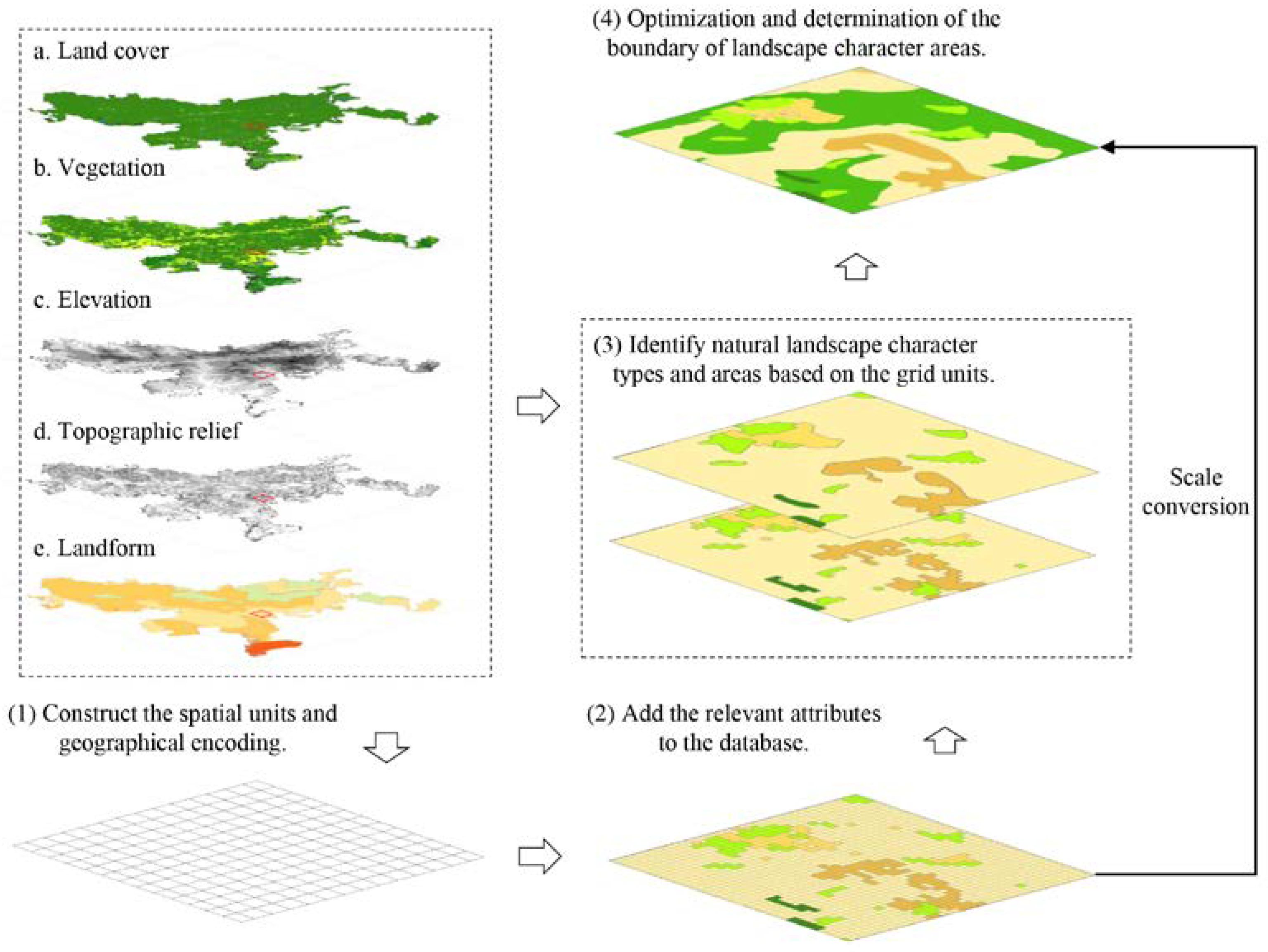
2.4.1. Identification Methods for Individual and Combined Natural Landscapes

Through field research, remote sensing images, and the Mount Wuyi National Park Ecological Recreation Special Plan, 341 individual natural landscape resource points in Mount Wuyi National Park were identified. We utilized ArcGIS 10.6 software to digitize and map individual natural landscape resource points. Landscape resource information, such as resource name, latitude and longitude, resource type, resource grade, and feature information, were organized. According to the standard ‘National Park Resource Survey and Evaluation Norms (LY/T 3189-2020)’, individual natural landscape resources include four major types: physiographic landscape, hydrological landscape, biological landscape, and astronomical and climatic landscape (Figure 2). The kernel density analysis method [24] was used to depict the spatial aggregation or dispersion characteristics of individual natural landscape resources within the study area.
f ( j ) = i = 1 n k π r 2 ( d i j r )
where f(j) is the density of point j, r represents the search radius, dij is the distance from point i to point j, k is the weight of dij, n is the total number of the individual natural landscape resource points, and n is 341 in this study.
Combined natural landscapes, based on the biophysical attributes of landscapes (e.g., land cover, vegetation, and topography), utilizing both the holistic and parametric approaches of the Landscape Character Assessment method [24], identify combined natural landscape types and spatial scopes with similar biophysical characteristics and natural geographic attributes. For instance, region A1 may simultaneously encompass meandering rivers, Danxia landforms, and vegetation landscapes, while region A2 may consist of fault zones, vegetation, and cloud-mist scenery.
The holistic approach is based on a logical framework that starts with the whole and then the parts. It first constructs an initial spatial framework based on the important features of the landscape and then gradually refines and expands the landscape types through detailed information [25]. This method enables the rapid identification and establishment of landscape character areas within the study region, requiring human expertise in landscape classification [26]. Parametric methods typically involve an overlay of three or more sets of landscape elements (e.g., land use, soil, and topography) to aggregate and summarize thematic data, thereby identifying landscape character areas. This approach relies more on the accuracy of data sources [25]. This study employed a comprehensive strategy that combined holistic and parametric methods to identify combined natural landscapes through the following steps (Figure 3):
(1)
The fishnet tool in ArcGIS 10.6 was employed to construct spatial base units of 100 m × 100 m based on previous studies [26,27] and the area of the study region (1279.82 km2). Each grid cell was uniquely coded to facilitate the extraction of constituent elements of the combined natural landscapes for subsequent analysis.
(2)
According to the studies by Warnock et al. and Castillo-Rodríguez et al. [28,29], and considering the characteristics of the study area, land cover, vegetation, topography, and geomorphology were selected as the fundamental elements for delineating combined natural landscapes (Table 2). These data were integrated into the pre-established spatial grid cells using ArcGIS 10.6 software. The k-means clustering method [25], which is suitable for large-scale sample analysis, was employed to categorize combined natural landscape types initially.
(3)
The initial boundaries of the combined natural landscapes were spatially visualized using ArcGIS 10.6 software. Subsequently, the same type of grid units was spatially merged and smoothed to determine the initial boundaries of natural landscape character areas. Additionally, the characteristics of each type of combined natural landscape were described.
(4)
Integrating satellite remote sensing image data with field survey data, a holistic approach was employed to manually adjust and refine the boundaries of the combined natural landscape formed in the previous step. Emphasis was placed on categorizing vegetation landscapes into finer types, merging landscapes that were too small in area and fragile water landscapes, and other measures to achieve a refined processing of the combined natural landscape boundaries. This process established the final combined natural landscapes with distinct natural geographic attributes.

2.4.2. Evaluation of Aesthetic Quality of Individual and Combined Natural Landscapes

Based on the principles of transferability, quantifiability, cartography, relevance, and data availability [11], this study was based on the six dimensions of landscape aesthetics (i.e., landscape aesthetic services, uniqueness, richness, diversity, composition, harmony, and visual scale) proposed in Section 2.1, and 17 relevant indicators were selected to construct an evaluation index system for the aesthetic value of natural landscapes in national parks (Table 3). This index system was used to assess the aesthetic value of individual and combined natural landscapes in the study area.
Landscape aesthetics are associated with objective information such as form, visual characteristics, recognizability, and biophysical attributes of the natural landscape itself. They are also influenced by subjective judgment factors, including the observer’s aesthetics and cognition. Therefore, in this study, we selected an Analytic Hierarchy Process (AHP) based on human subjective experience and the entropy weight method, representing the objective information of landscape entities, to comprehensively calculate the index weights.
First, the AHP relies on the prior knowledge of scoring experts to determine index weights by constructing a judgment matrix [30]. This method involves four steps for weight calculation: construction of a hierarchical model, formation of a judgment matrix, weight computation, and a consistency check. Twelve experts from the fields of landscape planning, tourism geography, and ecotourism were invited to compare and score various factors (Supplementary File), ultimately obtaining 10 valid questionnaires. The formula for calculating the weights of the indicators using the AHP is as follows:
w i = ( j = 1 n a i j ) 1 n i = 1 n ( j = 1 n a i j ) 1 n   ,   i = 1 , 2 , 3 , n
where aij represents the numerical value corresponding to the importance of elements i and j in the target layer, and wi denotes the weight of the ith indicator.
Second, to avoid the subjective biases introduced by human factors, the entropy weight method generally determines the weight of the information inherent in the indicators [31]. This method serves as an objective tool for measuring the weights of the indicators. This study utilized ArcGIS 10.6 software to integrate the values of individual and combined natural landscape indicators of Mount Wuyi National Park into 100 m × 100 m unit grids. The standardized data were then subjected to entropy weight calculations to determine the objective weights of each indicator.
e j =   1 l n   n i = 1 n x i j i = 1 n x i j l n x i j i = 1 n x i j
θ j = 1 e j j = 1 m ( 1 e j )
where xij represents the standardized value of the jth indicator of the ith grid, ej denotes the information entropy of the jth indicator, θ j signifies the weight of the jth indicator, n is the total number of unit grids, which is 132,085 in this study, and m represents the number of indicators.
Finally, the comprehensive weights were determined based on subjective and objective methods. Referring to the composite weight calculation method proposed by Hou and Huang [32], this study combined the subjective and objective weights derived from the Analytic Hierarchy Process and entropy weight methods through a composite operation, ultimately determining the comprehensive weight of the aesthetic value of the natural landscapes in Mount Wuyi National Park (Table 3).
λ j = ω j θ j j = 1 m ω j θ j
where ω j and θ j represent the weights calculated by the Analytic Hierarchy Process and the Entropy Weight Method, respectively, m denotes the number of indicators, and λ j are the final comprehensive weights.
The weight evaluation results indicate that, in terms of the individual natural landscape dimensions of Mount Wuyi National Park, the weights from high to low are as follows: uniqueness (A2), landscape aesthetic services (A1), diversity (A4), combination (A3), and visual scale (A5). For combined natural landscapes, the weights from highest to lowest were uniqueness (A7), diversity (A8), landscape aesthetic services (A6), coordination (A9), and visual scale (A10).

3. Results

3.1. Identification and Spatial Analysis of Individual and Combined Natural Landscapes

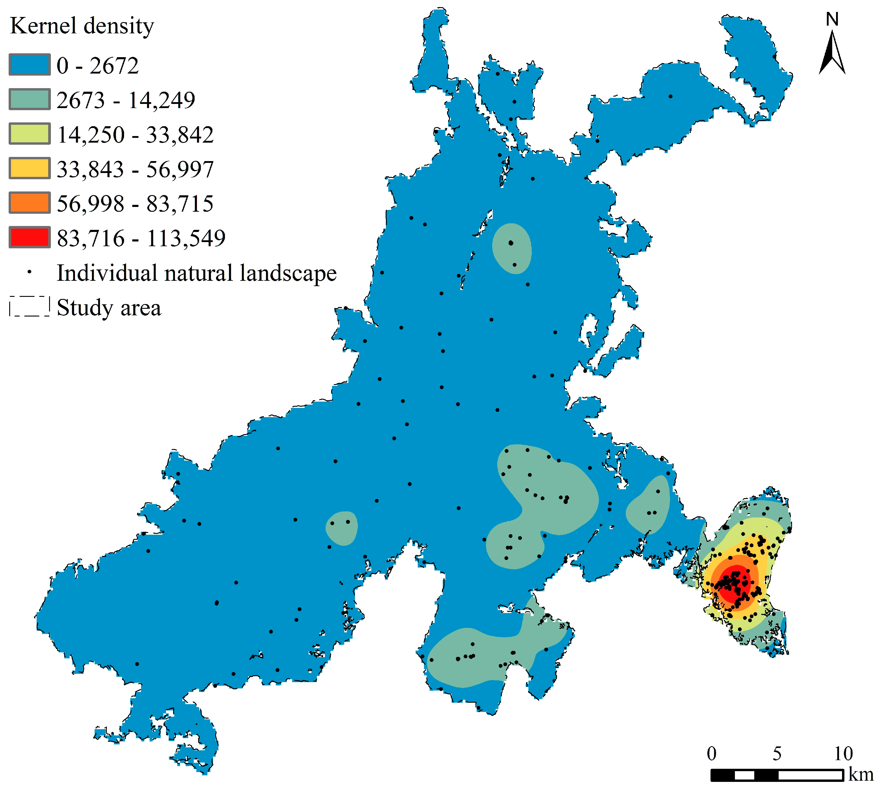
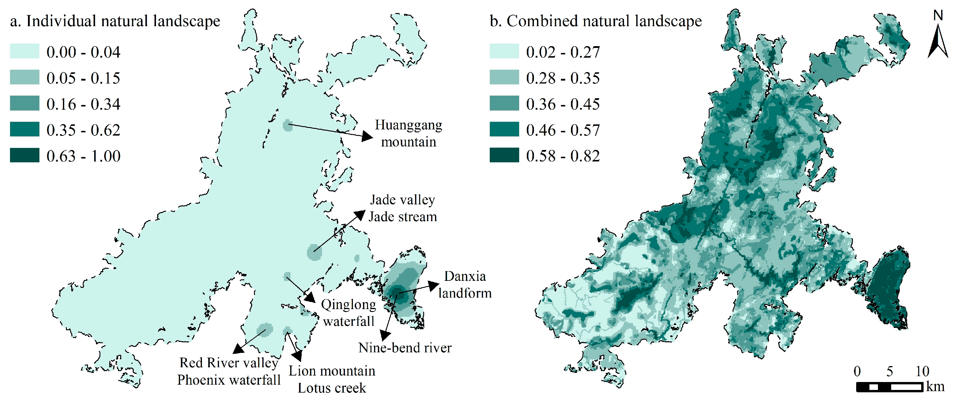
3.1.1. Spatial Distribution Characteristics of Individual Natural Landscapes

Kernel density analysis of individual natural landscapes in Mount Wuyi National Park revealed a high concentration of individual natural landscape resources in the southern and eastern regions. In contrast, the northern and western regions displayed a lower density of resources (Figure 4). The individual natural landscapes in the southeastern region of the research area exhibited a highly clustered distribution, forming a circular distribution pattern with the southern part (Nine-Bend River area) as the central core and a gradual decrease in outward density. The individual natural landscapes in the western region of the Nine-Bend River and some areas in the southern part of the study area were relatively concentrated, creating a secondary core area for the distribution of individual natural landscapes in the research area. The uneven distribution characteristics of individual natural landscape resources in the remaining areas were more pronounced, with a weak link between individual natural landscape resource points.

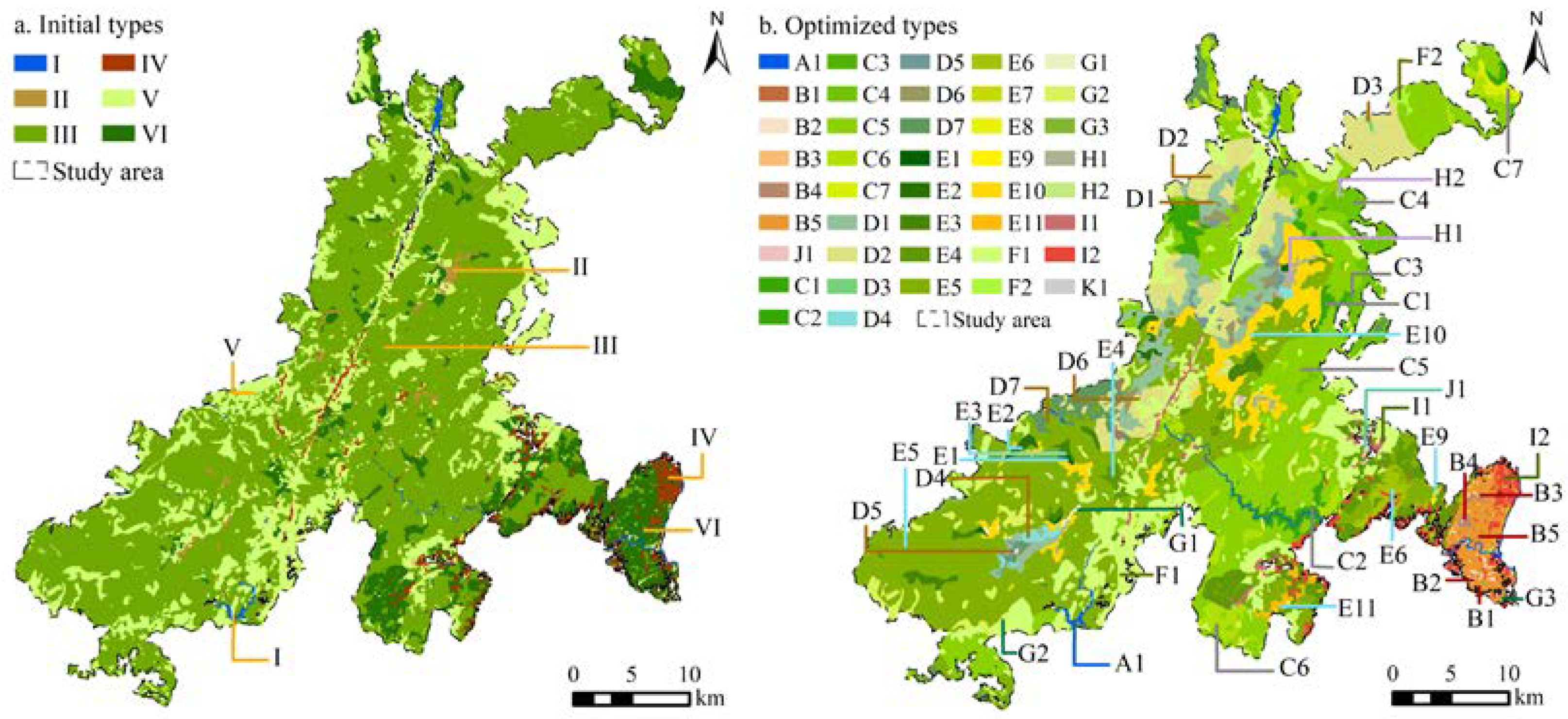
3.1.2. Boundaries and Spatial Characteristics of Combined Natural Landscapes

Ten types of combined natural landscapes in Mount Wuyi National Park were preliminarily obtained by using the k-means clustering method (Supplementary File). Based on the remote sensing image data, we merged and adjusted the types with similar landscape features and optimized the ten combined natural landscape types into six categories (Figure 5a). Type I refers to meandering river valley areas, including river sections suitable for sightseeing (e.g., the Nine-Bend River) and artificial reservoirs (e.g., the Gaodian Reservoir). Type II refers to grassland-dominated vegetation landscapes with higher regional altitudes and relatively flat terrain. Type III is a vegetation landscape area mainly composed of mountainous evergreen and deciduous broad-leaved mixed forests. This combination accounts for 62.54% of the total study area. Type IV is a vegetation landscape dominated by artificial economic forests (e.g., tea gardens and orchards). Type V is a composite natural landscape area that covers multiple vegetation types, such as broadleaved forests, coniferous forests, shrubs, and bamboo forests. Type VI is a combined natural landscape area mainly composed of coniferous and broad-leaved mixed forests and characteristic landforms (e.g., Danxia and granite landforms).
Although the spatial heterogeneity of the six types of combined natural landscape areas mentioned above can, to some extent, represent and distinguish the main features of the natural landscapes in the study area, there are still issues, such as insufficient differentiation of terrain and landform elements, mixed landscape types, and high fragmentation of micro-scale landscapes. Using satellite images and field research in the study area, we further refined the types and boundaries of the combined natural landscapes. Ultimately, 41 combined natural landscape types were identified (Figure 5b). Type K1 in Figure 5b is a non-natural landscape type excluded from the final classification of combined natural landscapes.
The specific connotations of 41 types of combined natural landscapes are as follows: Type A1 is a water landscape; types B1-B5 include the most distinctive combination landscape of Danxia landform and diverse vegetation in the study area; types C1-C7 are a combination of diverse vegetation, terrain, and granite landscape; types D1-D7 display a combination of diverse vegetation, terrain, and volcanic landscape; types E1-E11 are a combination of diverse vegetation, terrain, and debris rock landscape; types F1-F2, G1-G3, and H1-H2 represent the landscapes of bamboo forests, shrubs, and grasslands at different altitudes; types I1-I2 showcase the ecological tea garden landscape in the study area; and type J1 is a farmland landscape dominated by ecological orchards.

3.2. Aesthetic Quality Analysis of Individual and Combined Natural Landscapes

The aesthetic quality of the individual natural landscapes of Mount Wuyi National Park showed clear spatial differentiation (Figure 6a). The high-value areas were mainly concentrated in the southeastern part of the study area, forming a trend of gradual decline in aesthetic value when spreading to the periphery, with core landscape resources, such as the Nine-Bend River and Danxia landform landscape. The aesthetic quality of individual natural landscapes in the western part of the Nine-Bend River (e.g., Jade Valley, Qinglong Waterfall, and Lion Mountain) and the Huanggang Mountain area in the north of the study area was distributed at a relatively low level, becoming the secondary center of the aesthetic value of individual natural landscapes in the study area. In the remaining regions, the aesthetic quality of the landscapes was generally low for reasons such as the scarcity of distinctive natural scenery, lack of prominence, poor combination, richness, and visual scale.
Compared to individual natural landscapes, the overall aesthetic value of the combined natural landscapes was higher (Figure 6b). Influenced by landscape aesthetic services, uniqueness, diversity, coordination, and visual scale, high-level and higher-level areas were concentrated in parts of the northern and central-western regions of the study area, as well as in the southeast, where a combination of characteristic natural landscapes featured Danxia landforms, scenic river sections, vegetation, and celestial phenomena. The aesthetic value of the combined natural landscapes in the central, eastern, northern, and southern regions of the study area was moderate or low, which was related to factors such as insufficient supply capacity of landscape aesthetic services, high homogeneity level, insufficient diversity of levels and types, poor coordination, and visual scale.

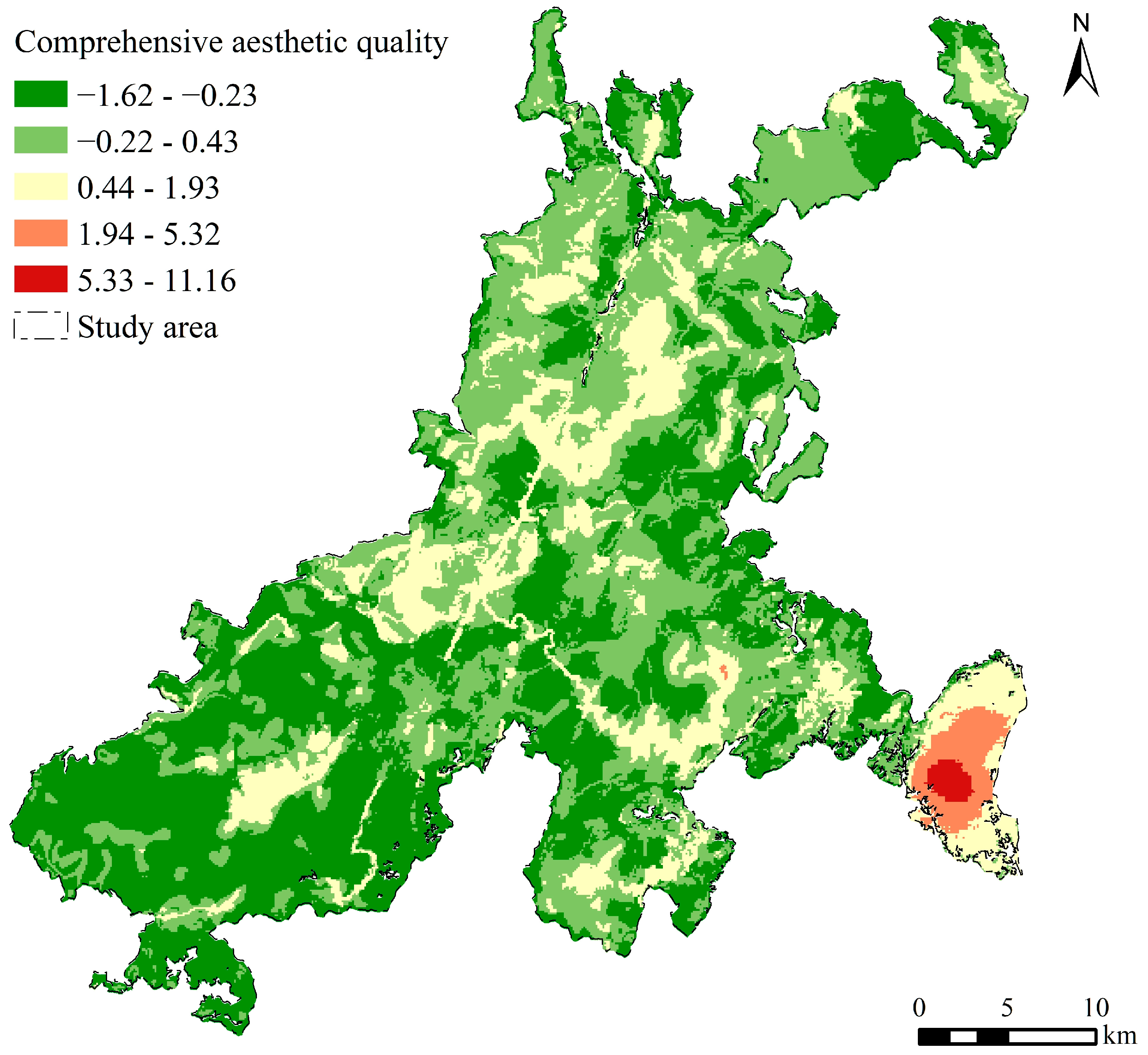
3.3. Comprehensive Analysis of the Aesthetic Quality of Natural Landscapes

The comprehensive aesthetic value of the natural landscapes of Mount Wuyi National Park showed that natural landscapes with high- and higher-level aesthetic values in the study area were mainly concentrated in the southeast (Figure 7). This part of the region, first, possessed unique natural landscape resources of the study area: the Danxia landform landscape (e.g., Tianyou Peak, Dawang Peak, and Yunv Peak). Second, the landscape cluster formed by the combination of diverse natural landscapes, such as the Danxia landform landscape, water bodies, vegetation, and celestial phenomena, could also provide high aesthetic value. Third, the natural landscape richness, diversity, and coordination levels in this area were relatively high, which was conducive to promoting landscape aesthetic value enhancement.
Areas with a moderate level of comprehensive aesthetic value were mainly distributed in the northern, southwestern, and southeastern regions of the study area. The uniqueness of natural landscapes in this region showed certain disparities compared to those in the southeast, yet high-level and diverse vegetation coverage, volcanic rocks, granite, and debris landforms could also serve certain aesthetic functions. The combination of canyons, fractures, forests, and waterfalls comprehensively enhances the aesthetic value of natural landscapes by improving their hierarchy, richness, and coordination within the visual range.
Areas with low aesthetic value were mainly distributed in the southwestern and east-central parts of the study area. The aesthetic values of the individual and combined natural landscapes in this area were relatively low, resulting in a lower overall aesthetic value of the natural landscapes. In contrast to high-value areas of natural landscape aesthetic value, the natural landscapes lacked sufficient attraction for tourists in terms of visual enjoyment and recreational activities, thus providing tourists with limited aesthetic experiences, a sense of place, belonging, and happiness.

4. Discussion and Limitations

4.1. Discussion

In the context of dynamic interactions between humans and landscapes, the scientific assessment of the aesthetic quality of natural landscapes contributes to mitigating and effectively addressing the threats posed by human activities to landscapes [13]. Our findings indicate that uniqueness, landscape aesthetic services, and diversity consistently comprise a significant proportion of the weight distribution of aesthetic quality for both individual and combined natural landscapes. The findings indicate that, at the micro-scale, the uniqueness and diversity of natural landscapes exert a significant influence on their aesthetic quality, which is consistent with the framework of landscape aesthetic quality characterized by ‘‘uniqueness, diversity, and naturalness’’ at meso-scale and macro-scale [12,13,14]. Additionally, our findings reveal that the aesthetic services provided by natural landscapes contribute significantly to the aesthetic quality of landscapes, indicating that the provision of non-material cultural ecosystem services, such as aesthetic appreciation and recreational activities, plays a positive role in enhancing the appeal of landscapes and promoting human well-being [21,33].
Existing studies on individual natural landscape aesthetics often utilize PPGIS [9,15], photo questionnaires [4], and eye-tracking analysis [34] methods to assess the landscape aesthetic quality by analyzing tourists’ perceived quality of landscape photos and textual information. These methods rely more on tourists’ subjective impressions, and the accuracy and reliability of the evaluation results hinge on the sample size and emotional tendencies of the tourists. In existing research on constructing an indicator system for evaluating the combined natural landscape aesthetics, three aspects are focused on [13,19]: naturalness, diversity, and uniqueness. These studies often focus on land use data or specific ecological spaces as research objects, and the accuracy and scientificity of identifying landscape types need to be improved. This study distinguishes and delineates individual and combined natural landscapes and their spatial characteristics and selects indicators to establish a landscape aesthetic quality evaluation system, which is an optimization and effective supplement to existing research.
Individual natural landscapes are predominantly located in the southeastern region of the study area, which correlates with the fact that this area was originally part of the Mount Wuyi Scenic Area, where the development and utilization of natural landscape resources are relatively well established. Based on data associated with natural attributes, such as land cover, vegetation, topography, and landforms, in this study we employed the Landscape Character Assessment methodology, commonly utilized in landscape characteristic classification [26,28,35], to delineate and identify the combined natural landscape types and spatial regions. In general, fixed spatial units are more objective for element integration and spatial analysis research [36]. Yang et al. [26] and Willemen et al. [27] selected 100 m × 100 m grid cells for spatial analysis when studying the landscape functions of Lushan National Park (approximately 302 km2) and Gelderse Vallei (approximately 750 km2) in the Netherlands, respectively. Therefore, drawing on existing research [26,27] and the area of the study region (1279.82 km2), this study adopted a regular grid unit (100 m × 100 m) as the fundamental unit for data collection, aiming to achieve an objective delineation of landscape units.
This study revealed that the southeastern region, with high landscape aesthetic quality, boasts dense natural landscape resources. Furthermore, the distinctive natural landscape cluster in the southeastern region, consisting of the Danxia landform, Nine-Bend River, vegetation, mist, and fracture landscapes, significantly enhanced the aesthetic quality of natural landscapes. This phenomenon indicates that the aesthetic quality of natural landscapes is closely associated with the quantity of landscape resources, landscape uniqueness, and provision of aesthetic services [13]. The overall aesthetic quality of the combined natural landscapes was superior to that of individual natural landscapes, indicating that diverse and harmonious clusters of natural landscapes exert a more positive influence on aesthetic quality than individual natural landscapes [22,23]. Additionally, while the visual scale’s impact on landscape aesthetic quality was limited in this study, research has shown that objective visual conditions, such as elevation and distance, can influence landscape aesthetic quality by adjusting the human capacity to perceive landscapes [4,9]. Areas with lower landscape aesthetic quality were primarily distributed in the southwestern and eastern central regions of the study area. These regions have limited attractiveness in terms of landscape aesthetic services and recreational functions. Natural landscapes in these areas should be prioritized for protection and restoration.

4.2. Limitations and Future Perspectives

Based on aesthetic services, uniqueness, combination, diversity, coordination, and visuality of natural landscape aesthetics, this study constructs a multidimensional evaluation system for the aesthetic quality of natural landscapes in national parks for comprehensive evaluation and spatial analysis. However, this study has certain limitations. First, constrained by the difficulty of data acquisition, this study did not incorporate elements such as seasonal changes and colors of natural landscapes into the evaluation system when assessing the coordination level of natural landscapes. The visual scale dimension has not yet considered difficult-to-quantify aspects of field-of-view openness and visibility. Future research can be enhanced by integrating diverse methods such as psychophysical approaches, participatory geographic information technology, and eye-tracking experiments. Second, given the growing integration of human activities with natural landscapes, future studies should consider integrating visitors’ aesthetic preferences into evaluations of landscape aesthetic quality. A comprehensive assessment system that takes into account both subjective and objective factors can be constructed, thereby improving the overall accuracy and applicability of the assessment results.

5. Conclusions

This study established an evaluation framework and indicator system tailored to the aesthetic quality of individual and combined natural landscapes within national parks, identifying the spatial types and boundaries of individual and combined natural landscapes in the study area, and delineating the spatial patterns and distribution characteristics of the aesthetic quality of natural landscapes. The findings indicated that the 341 individual natural landscapes within Mount Wuyi National Park predominantly exhibited a distribution pattern characterized by greater density in the south and east and lower density in the north and west, with the northern and western regions showing a more dispersed distribution of individual landscape resources. Employing both holistic and parametric methods of Landscape Character Assessment, the combined natural landscapes were categorized into 6 major types and 41 subtypes, encompassing a variety of spatial combinations, such as winding river valleys, distinctive Danxia landforms, vegetation, and man-made economic forests.
The spatial heterogeneity of aesthetic quality in natural landscapes is pronounced, with the southeastern region characterized by a dense distribution of natural landscape resources and core assets, such as the Nine-Bend River and unique Danxia landform scenery, identified as a high-value area for landscape aesthetic quality. Influenced by factors such as the supply capacity of aesthetic services, uniqueness, diversity, and coordination of natural landscapes, the landscape aesthetic quality in the western section of the Nine-Bend River and the northern region of the study area, specifically the Huanggang Mountain-Mount Wuyi Grand Canyon, is moderate. Additionally, the overall aesthetic quality of the combined natural landscapes tended to be higher than that of individual natural landscapes, indicating that diverse and rich clusters of landscapes are more appealing in terms of aesthetic appreciation and recreational activity. These findings have positive implications for the scientific assessment of landscape aesthetic quality in national parks and for the sustainable planning and management of landscapes.

Supplementary Materials

The following supporting information can be downloaded at: https://www.mdpi.com/article/10.3390/land13101674/s1, Table S1: Index system for evaluating the aesthetic value of individual natural landscapes. Table S2: Uniqueness (A2) evaluation indicators of individual natural landscapes. Table S3: Index system for evaluating the aesthetic value of combined natural landscapes. Table S4: Diversity (A8) evaluation indicators of combined natural landscapes. Table S5: Coordination (A9) evaluation indicators of combined natural landscapes. Table S6: Visual scale (A10) evaluation indicators of combined natural landscapes. Table S7: K-means clustering final cluster center.

Author Contributions

Conceptualization, X.Z.; Software, X.Z.; Validation, Y.L.; Formal analysis, Y.L.; Writing—original draft, X.Z.; Supervision, Z.Y.; Project administration, Z.Y.; Funding acquisition, Z.Y. All authors have read and agreed to the published version of the manuscript.

Funding

This research was funded by The National Key Research and Development Program of China, grant number 2022YFF1301403; Xinjiang Science and Technology Major Project, grant number 2022A03002. The APC was funded by The National Key Research and Development Program of China, grant number 2022YFF1301403.

Data Availability Statement

The data that have been used are confidential.

Conflicts of Interest

The authors declare no conflicts of interest.

References

  1. Tatum, K.; Porter, N.; Hale, J. A feeling for what’s best: Landscape aesthetics and notions of appropriate residential architecture in Dartmoor National Park, England. J. Rural. Stud. 2017, 56, 167–179. [Google Scholar] [CrossRef]
  2. He, S.Y.; Su, Y.; Min, Q.W. Boundary, zoning, and land use management of the China National Parks: Learning from Nature Reserves and Scenic Areas. Acta Ecol. Sin. 2019, 29, 1318–1329. (In Chinese) [Google Scholar]
  3. Wang, Q.; Wu, Y.G.; Ren, M.X.; Li, B.L. Suggestions on optimizing the planning of national parks and national nature reserves in China. Sci. Technol. Rev. 2023, 41, 14–20. (In Chinese) [Google Scholar]
  4. Nowak-Olejnik, A.; Schirpke, U.; Tappeiner, U. A systematic review on subjective well-being benefits associated with cultural ecosystem services. Ecosyst. Serv. 2022, 57, 101467. [Google Scholar] [CrossRef]
  5. Cheng, X. A Review of Empirical Studies of Cultural Ecosystem Services in National Parks: Current Status and Future Research. Land 2023, 12, 1912. [Google Scholar] [CrossRef]
  6. Schirpke, U.; Zoderer, B.M.; Tappeiner, U.; Tasser, E. Effects of past landscape changes on aesthetic landscape values in the European Alps. Landsc. Urban Plan. 2021, 212, 104109. [Google Scholar] [CrossRef]
  7. Zube, E.H. Perceived land use patterns and landscape values. Landsc. Ecol. 1987, 1, 37–45. [Google Scholar] [CrossRef]
  8. Huang, Y.; Zhao, Z.B.; Zhang, C.; Chen, Y. Spatial constitution and group differences in landscape values in the tourism community. Tour. Trib. 2016, 31, 80–90. (In Chinese) [Google Scholar]
  9. Gine, D.S.; Albert, M.Y.P.; Buendia, A.V.P. Aesthetic assessment of the landscape using psychophysical and psychological models: Comparative analysis in a protected natural area. Landsc. Urban Plan. 2021, 214, 104197. [Google Scholar] [CrossRef]
  10. Tveit, M.; Ode, Å.; Fry, G. Key concepts in a framework for analysing visual landscape character. Landsc. Res. 2006, 31, 229–255. [Google Scholar] [CrossRef]
  11. Ode, A.; Tveit, M.S.; Fry, G. Capturing landscape visual character using indicators: Touching base with landscape aesthetic theory. Landsc. Res. 2008, 33, 89–117. [Google Scholar] [CrossRef]
  12. Hermes, J.; Albert, C.; von Haaren, C. Assessing the aesthetic quality of landscapes in Germany. Ecosyst. Serv. 2018, 31, 296–307. [Google Scholar] [CrossRef]
  13. Kalinauskas, M.; Miksa, K.; Inacio, M.; Gomes, E.; Pereira, P. Mapping and assessment of landscape aesthetic quality in Lithuania. J. Environ. Manag. 2021, 286, 112239. [Google Scholar] [CrossRef]
  14. Hou, Y.Z.; Zhao, W.W.; Hua, T.; Pereira, P. Mapping and assessment of recreation services in Qinghai-Tibet Plateau. Sci. Total Environ. 2022, 838, 156432. [Google Scholar] [CrossRef]
  15. Solecka, I.; Rinne, T.; Martins, R.C.; Kytta, M.; Albert, C. Important places in landscape—Investigating the determinants of perceived landscape value in the suburban area of Wrocław, Poland. Landsc. Urban Plan. 2022, 218, 104289. [Google Scholar] [CrossRef]
  16. Zhou, N.X.; Huang, Z.F.; Jiang, M.P.; Liang, Y.Y. The relationships between forest landscape visual quality and landscape spatial pattern index of Mount Lushan. Geogr. Res. 2012, 31, 1224–1232. (In Chinese) [Google Scholar]
  17. Xu, L.L.; Yu, H. Research progress of international landscape evaluation, protection, and utilization of national parks and implications to China. Resour. Sci. 2022, 44, 1520–1532. (In Chinese) [Google Scholar] [CrossRef]
  18. Wang, P.; Yang, W.J.; Wang, D.J.; He, Y.J. Insights into Public Visual Behaviors through Eye-Tracking Tests: A Study Based on National Park System Pilot Area Landscapes. Land 2021, 10, 497. [Google Scholar] [CrossRef]
  19. Liu, H.C.; Sun, Z.R.; Wu, J.Y.; Yu, H.; Yang, X.M.; Zhou, D.J. Evaluation of natural landscape aesthetic value and its spatial differentiation in Tibet from the perspective of ecosystem services. Prog. Geogr. 2023, 42, 1961–1972. (In Chinese) [Google Scholar] [CrossRef]
  20. Du, A.; Xu, W.H.; Xiao, Y.; Cui, T.; Song, T.Y.; Ouyang, Z.Y. Evaluation of Prioritized Natural Landscape Conservation Areas for National Park Planning in China. Sustainability 2020, 12, 1840. [Google Scholar] [CrossRef]
  21. LY/T 3189-2020; National Park Resource Survey and Evaluation Norms. National Forestry and Grassland Administration: Beijing, China, 2020.
  22. Albaladejo-García, J.A.; Zabala, J.A.; Alcon, F.; Dallimer, M.; Martínez-Paz, J.M. Integrating socio-spatial preference heterogeneity into the assessment of the aesthetic quality of a Mediterranean agricultural landscape. Landsc. Urban Plan. 2023, 239, 104846. [Google Scholar] [CrossRef]
  23. Yuan, S.; Browning, M.H.E.M.; McAnirlin, O.; Sindelar, K.; Shin, S.; Drong, G.; Hoptman, D.; Heller, W. A virtual reality investigation of factors influencing landscape preferences: Natural elements, emotions, and media creation. Landsc. Urban Plan. 2023, 230, 104616. [Google Scholar] [CrossRef]
  24. Pantano, E.; Scarpi, D.; Vannucci, V.; Bilotta, E.; Pantano, P. Probability-density risk-maps for tourism during emergencies. Ann. Tour. Res. 2022, 92, 103259. [Google Scholar] [CrossRef]
  25. Van Eetvelde, V.; Antrop, M. A stepwise multi-scaled landscape typology and characterisation for trans-regional integration, applied on the federal state of Belgium. Landsc. Urban Plan. 2009, 91, 160–170. [Google Scholar] [CrossRef]
  26. Yang, D.C.; Gao, C.; Li, L.Y.; Van Eetvelde, V. Multi-scaled identification of landscape character types and areas in Lushan National Park and its fringes, China. Landsc. Urban Plan. 2020, 201, 103844. [Google Scholar] [CrossRef]
  27. Willemen, L.; Verburg, P.H.; Hein, L.; van Mensvoort, M.E.F. Spatial characterization of landscape functions. Landsc. Urban Plan. 2008, 88, 34–43. [Google Scholar] [CrossRef]
  28. Warnock, S.; Griffiths, G. Landscape Characterisation: The Living Landscapes Approach in the UK. Landsc. Res. 2015, 40, 261–278. [Google Scholar] [CrossRef]
  29. Castillo-Rodriguez, M.; Lopez-Blanco, J.; Munoz-Salinas, E. A geomorphologic GIS-multivariate analysis approach to delineate environmental units, a case study of La Malinche volcano (central Mexico). Appl. Geogr. 2010, 30, 629–638. [Google Scholar] [CrossRef]
  30. Gong, J.; Jin, T.T.; Cao, E.J.; Wang, S.M.; Yan, L.L. Is ecological vulnerability assessment based on the VSD model and AHP-Entropy method useful for loessial forest landscape protection and adaptative management? A case study of Ziwuling Mountain Region, China. Ecol. Indic. 2022, 143, 109379. [Google Scholar] [CrossRef]
  31. Tang, C.C.; Yang, Y.Y.; Liu, Y.; Xiao, X.Y. Comprehensive evaluation of the cultural inheritance level of tourism-oriented traditional villages: The example of Beijing. Tour. Manag. Perspect. 2023, 48, 101166. [Google Scholar] [CrossRef]
  32. Hou, G.L.; Huang, Z.F. Evaluation on tourism community participation level based on AHP method with entropy weight. Geogr. Res. 2010, 29, 1802–1813. (In Chinese) [Google Scholar]
  33. Schirpke, U.; Timmermann, F.; Tappeiner, U.; Tasser, E. Cultural ecosystem services of mountain regions: Modelling the aesthetic value. Ecol. Indic. 2016, 69, 78–90. [Google Scholar] [CrossRef] [PubMed]
  34. Guo, S.L.; Zhao, N.X.; Zhang, J.X.; Xue, T.; Liu, P.X.; Xu, S.; Xu, D.D. Landscape visual quality assessment based on eye movement: College student eye-tracking experiments on tourism landscape pictures. Resour. Sci. 2017, 39, 1137–1147. (In Chinese) [Google Scholar]
  35. Simensen, T.; Halvorsen, R.; Erikstad, L. Methods for landscape characterisation and mapping: A systematic review. Land Use Policy 2018, 75, 557–569. [Google Scholar] [CrossRef]
  36. Bao, Z.T.; Jiang, D.Z.; Zhou, J.Y.; Huang, Y.X. Delineation of spatial units for landscape planning and management based on Landscape Character Assessment (LCA) on territorial scale. Chin. Landsc. Archit. 2023, 39, 46–52. [Google Scholar]
Figure 1. Visual contrast between individual and combined natural landscapes of Yunv Peak. The left image depicts an individual natural landscape, while the right image showcases a combined natural landscape. Notes: The images are sourced from the Visual China website (https://www.vcg.com/, accessed on 1 May 2024).
Land 13 01674 g001
Figure 2. Location map of Mount Wuyi National Park. Notes: The images are sourced from the Visual China website (https://www.vcg.com/, accessed on 1 May 2024).
Land 13 01674 g002
Figure 3. Flowchart of combined natural landscape area identification and optimization.
Land 13 01674 g003
Figure 4. Distribution of kernel density of individual natural landscapes in Mount Wuyi National Park.
Land 13 01674 g004
Figure 5. Types of combined natural landscapes in Mount Wuyi National Park.
Land 13 01674 g005
Figure 6. Aesthetic quality of individual and combined natural landscape in Mount Wuyi National Park.
Land 13 01674 g006
Figure 7. Comprehensive aesthetic quality of the natural landscape in Mount Wuyi National Park.
Land 13 01674 g007
Table 1. Key dimensions of aesthetic quality in natural landscapes.
No.DimensionsConnotationApplicable Scope
1Landscape aesthetic servicesThe natural characteristics of the landscape, along with the existence of vegetation, water bodies, or distinctive landforms, can offer cultural ecosystem services, such as scenic viewing, recreational experiences, and opportunities for relaxation, to human beings.Individual and combined natural landscapes
2UniquenessUniqueness refers to the distinguishable attributes of a landscape. The landscape possesses a compelling visual representation that imbues it with distinctive qualities and a singular sense of place.Individual and combined natural landscapes
3DiversityThe complexity and changing characteristics of landscapes in both time and space.Individual and combined natural landscapes
4CombinationThe quantity abundance and combination characteristics of individual landscape resources.Individual natural landscapes
5CoordinationCoordination refers to the unity and coherence of the landscape, including the degree of visual coordination between landscape elements and between landscape and non-landscape elements.Combined natural landscapes
6Visual scaleThe environmental features surrounding the landscape can serve as spatial indicators for individuals to perceive the landscape, including factors such as topography and proximity.Individual and combined natural landscapes
Table 2. Fundamental elements of combined natural landscapes in Mount Wuyi National Park.
No.Element LayerIndex Layer
1Land coverL1 Orchard
2L2 Forest land
3L3 Grassland
4L4 Water
5Vegetation typeV1 Bamboo forest
6V2 Coniferous forest
7V3 Broadleaved forest
8V4 Shrubs
9V5 Deciduous broad-leaved mixed forest
10V6 Coniferous and broad-leaved mixed forest
11V7 Meadow
12V8 Artificial economic forest
13TopographyT1 Altitude (m)
14T2 Terrain relief
15LandformG1 Danxia Landform
16G2 Volcanic Rock Landform
17G3 Granite Landform
18G4 Clastic Rock Landform
Table 3. Natural landscape aesthetic value index system and its related weight values.
No.Landscape TypesDimensionsIndicators ω j θ j λ j
1Individual landscapeA1 Landscape aesthetic servicesAA1 Landscape resource observability0.2410.2090.263
2A2 UniquenessAA2 Rarity of landscape resources0.3370.2270.400
3AA3 Rarity of landscape resource types0.1240.2070.134
4A3 CombinationAA4 Combination degree of individual natural landscapes0.1060.1630.091
5A4 DiversityAA5 Abundance of individual natural landscapes0.1130.1800.106
6A5 Visual scaleAA6 Visual distance0.0790.0140.006
7Combined landscapeA6 Landscape aesthetic servicesAA7 Landscape aesthetic service value0.2710.0270.099
8A7 UniquenessAA8 Uniqueness of landscape characteristics0.4580.0880.549
9A8 DiversityAA9 Shannon’s diversity index0.0360.2620.129
10AA10 Relative patch richness0.0350.1210.058
11AA11 Diversity of landscape characteristic types0.0430.0540.031
12A9 CoordinationAA12 Patch aggregation index0.0210.2480.070
13AA13 Contagion index0.0180.0580.014
14AA14 Interference degree of road0.0290.0020.001
15AA15 Interference degree of construction land0.0380.0000.000
16A10 Visual scaleAA16 Altitude0.0330.0760.034
17AA17 Terrain relief0.0180.0640.016
Disclaimer/Publisher’s Note: The statements, opinions and data contained in all publications are solely those of the individual author(s) and contributor(s) and not of MDPI and/or the editor(s). MDPI and/or the editor(s) disclaim responsibility for any injury to people or property resulting from any ideas, methods, instructions or products referred to in the content.

