Abstract
Forest roads have been recognized as one of the significant contributors to soil erosion processes in forested areas. The construction and maintenance of forest roads can cause severe environmental impacts, including soil erosion, sedimentation, and degradation of aquatic ecosystems. The main objective of the present study is to analyze the impact of forest road networks on soil erosion and sedimentation in the context of the Zagros forestlands, Iran. This study aims to assess the soil erosion and sedimentation on forest roads in four case studies in the Zagros forestlands. This study collected data using field surveys and SEDMODL equations to determine input factors and sedimentation and erosion rates. This study found that roadside erosion is strongly correlated with geological factors, road width, and precipitation factors. The height changes of 144 benchmarks were recorded during one study year (2021–2022) on four study roads, and the measured results of erosion benchmarks indicated an average soil erosion of 3, 2.6, 4.7, and 3.5 mm per year around the Bideleh, Kohian, Nazi, and Tabarak roads, respectively. This study measured soil erosion and sedimentation at three distances (5, 15, and 25 m) from the road, and found a significant difference in the height changes of the benchmarks at varying distances from the study roads. A hot-spot analysis was conducted using GIS 10.8, and the results indicated that a significant portion of the studied forest roads had very high erosion production and hot spots. The results of the hot-spot analysis indicated that 30.8%, 22.6%, 39.8%, and 14.5% of the study forest roads, Nazi, Tabarak, Bideleh, and Kohian roads, respectively, are identified as areas with very high erosion production and hot spots. These results highlight the need for effective management strategies to minimize the impact of erosion on road infrastructure and the surrounding environment. Overall, this study provides important insights into the soil erosion and sedimentation on forest roads, and the findings presented here can be used to inform future road construction and maintenance.
1. Introduction
Communication roads and road networks are vital arteries for a society [1]. However, road construction is also considered a factor in the destruction of natural resources [2,3]. Nowadays, road construction is considered one of the basic problems for watersheds [4,5,6]. Unplanned road constructions destroy the unity of nature, collapse the life cycle of mountains, and cause large amounts of soil movement, leading to the destruction of animal and plant habitats, a reduction of aesthetic value, and damage to sensitive areas [7,8]. The construction and maintenance of forest roads are essential for forest management activities such as timber harvesting [9], fire prevention [10], and recreation [11]. However, forest road networks can have significant impacts on the environment, especially on soil erosion and sedimentation [12,13]. Soil erosion and sedimentation are major environmental problems in many parts of the world, including Iran [14,15], where extensive forest road networks have been developed over the years. Forest road networks can increase soil erosion and sedimentation by increasing the amount and velocity of water runoff [16], reducing the vegetative cover [17], and destabilizing the soil [8]. One of the biggest problems caused by road construction is the creation and increase of various forms of erosion, such as landslide [6], surface erosion [18], gully erosion [15], and debris-flow around the road [5]. During road construction in forest lands, a large area of the forest and range land along the road network is destroyed, and a significant amount of soil and stone is moved from its place or dumped on adjacent lands, doubling the intensity of environmental destruction [19]. Displaced soil and stone can also enter waterways and rivers and cause sedimentation in the reservoirs of dams, wetlands, lakes, seas, and even change the landscape morphology. Additionally, road construction is a factor in providing the basis for other erosion types [20,21]. The amount of environmental destruction and the area of forests and pastures resulting from road construction depend on various factors, such as the type of road, the topography of the area, the sensitivity of the soils, and any geological formations along the road route [4,8]. In recent years, the construction, repair, and maintenance of forest roads have received more attention than before because the construction of road networks increases concerns about the short- and long-term effects on the environment [22,23]. Therefore, the design of the road network should consider not only the cost of construction but the proper management of water and soil [24,25].
The reviewed studies conducted on road erosion worldwide stated that the destruction of vegetation by road construction is one of the important factors of soil erosion in watersheds. Cherati and Parsakhoo [12] studied the estimation of road sediment production by combining statistical sampling methods with the WARSEM model in an area in Tehran province, Iran. Their results showed that the amount of sediment estimated by the model is 3384 tons per year, equivalent to 157 tons per hectare in the area of the study roads, and they stated that the model has acceptable accuracy. The author of [23] conducted a study in the north of Iran, using the SEDMODL and geographic information system, to investigate the sedimentation of roads between agricultural farmlands in Iran. Their results showed that the amount of erosion caused by this road network is 423.9 tons per year without considering the rate of sediment delivery. Considering the rate of sediment delivery based on the distance from the waterway, sedimentation from the road network is around 12.85 tons per year, of which 8.58 tons are related to the surface of the road and roadside ditches, and 4 tons are related to the excavation trench. The author of [24] compared WEEP, Road Batch Model, and ABAG models on the estimation of surface soil erosion in the soil-filling part of forest roads in Turkey. The results of their study showed that for the WEEP and ABAG models, the annual loss of soil is 7.93 and 15.5 tons per year per hectare, respectively.
The Zagros forestlands in western Iran are of great importance both ecologically and culturally. These lands are home to a diverse range of plant and animal species, and have been home to human communities for thousands of years. The forest has played an important role in the culture of the local people, providing them with food, medicine, and materials for shelter and clothing. These forest lands are facing several threats, including deforestation, overgrazing, and erosion. Despite the importance of understanding the impacts of forest road networks on soil erosion and sedimentation, there is limited research on this topic in the Zagros forestlands of Iran. In addition, in the present study, the analysis of soil erosion at different distances from the forest road was considered using soil erosion measuring benchmarks. This study aims to fill this gap by conducting a hot-spot analysis of forest roads based on soil erosion and sedimentation in the Zagros forestlands. This is the first study to analyze soil erosion and sedimentation from forest roads in the culturally and ecologically significant Zagros forestlands of Iran. By using erosion benchmarks and a hot-spot analysis, it provides critical insights to guide sustainable forest management and target conservation efforts—filling an important research gap. The hot-spot analysis will identify areas where the impacts of forest road networks on soil erosion and sedimentation are most significant, which can help inform forest management practices and identify areas for targeted conservation efforts.
This study used the SEDMODL road sediment delivery model and geographic information system (GIS) to estimate the annual average soil erosion and sedimentation of the road network in four sections of forest road in Kuhrang and Lordegan counties, located in Chaharmahal and Bakhtiari Province, Iran. This research aims to deal with a part of soil erosion and destruction caused by the construction of forest roads in the Zagros forestlands. Additionally, a hot-spot analysis was conducted based on the SEDMODL and field measurement benchmarks to identify the areas along the studied roads with the highest potential for erosion and sediment production.
2. Materials and Methods
Chaharmahal and Bakhtiari Province, with an area of about 1,632,835 hectares, is located in the southwest of Iran between 31°9′ to 32°48′ N and 49°28′ to 51°25′ E. Chaharmahal and Bakhtiari is one of the high provinces of Iran and, for this reason, is considered one of the colder and rainier regions of Iran. The province has diverse climatic conditions due to the diversity of neighboring areas and the high-altitude changes in the province’s territory. The highest point in the province is the Zard Kouh peak, with a height of 4221 m; the lowest point is in Armand, next to the Karun River, with a height equivalent to 800 m above sea level [25]. Chaharmahal and Bakhtiari Province covers 320,000 hectares of the Zagros forestlands. These forests have great ecological and economic importance for the region, and the life of many species of animals and plants depends on them. Additionally, the economic and social life of nomads and rural people living in the region depends on these forests. The Zagros forestlands in western Iran are home to a diverse range of tree species, many of which are important for the local ecosystem and economy (Quercus brantii, Quercus infectoria, Pistacia atlantica, etc.). In the present research, four study sections of unpaved forest roads in Lordegan and Kuhrang counties (two road sections in each area) were selected for study. In general, this research studied two road sections in Kuhrang county (Tabarak, 5643 m long; and Nazi, 5171 m long) and two road sections in Lordegan county (Kohian, 3493 m long; and Bideleh, 5828 m long). Although these study roads differ in topography, geology, traffic volume, road type, age, and rainfall, we chose them to represent the general conditions of forest roads in the Zagros forestlands, and to study the erosion and sedimentation caused by the roads. The study roads are of the unpaved type with a sanded surface, built for the purpose of access to the villages of the region, as well as for the traffic of nomads, and for tourism purposes (Figure 1). The methodology in this study, except for terrain and in situ analyses, was supported by geographic information systems (GIS) and geostatistical calculations.
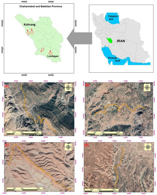
Figure 1.
Geographical location of the study roads, (a) Tabarak (b) Nazi, (c) Bideleh and (d) Kohian.
2.1. Methodology
The methodology of the present study is illustrated in the following flowchart (Figure 2). The study consisted of four main stages: (1) Estimation of soil erosion and sediment using SEDMODL, (2) Measurement of soil erosion using wooden benchmarks placed around the study roads, (3) Statistical analysis, and (4) Hot-spot analysis.
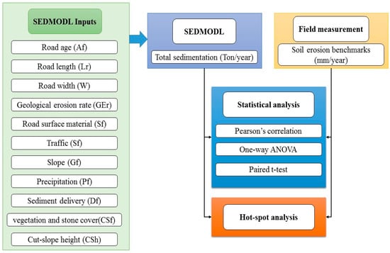
Figure 2.
Methodological flowchart of the present study.
2.1.1. SEDMODL
SEDMODL is a model commonly used for estimating soil erosion and sedimentation resulting from forest roads. This semi-empirical model predicts sediment delivery based on several factors, including road design, traffic, and environmental conditions [26]. The sedimentation resulting from forest roads is typically influenced by three types of water flow on the road surface, soil excavation, and roadside ditches. The model used in the study mentioned in this text is based on these three factors and is known as SEDMODL. Therefore, the total sedimentation per unit area per year from each road segment can be calculated based on an equation (Equation (1)), which is typically provided in the model’s documentation or related publications. In the present study, the study roads were divided into discrete segments to account for spatial variability in the model input factors. Segment boundaries were delineated based on changes in key variables (geological, slope, road age, precipitation, road width, distance from channel network, and traffic factors) required by the SEDMODL model. A total of 370 unique road segments were defined across the study area for the erosion modeling.
Equation (2) shows that the sedimentation caused by forest roads is influenced by several factors [19]. TS represents sedimentation from the road surface and roadside waterways, while CS represents sedimentation from cut-slope trenches. Af represents the age factor of the road. The equation shows that TS is influenced by road length (Lr), road width (W), geological erosion rate (GEr), road surface material (Sf), traffic (Tf), road slope (Gf), rainfall (Pf), and sediment delivery factors (Df). These factors can vary significantly depending on the specific characteristics of the forest road and the local environment. Therefore, accurately estimating the sedimentation from forest roads requires careful consideration of these factors, and the use of appropriate models and equations [12].
Equation (3) shows that the sedimentation caused by soil cut-slope trenches (CS) can be expressed as a function of several factors. These factors include the geological erosion rate (GEr), vegetation and stone cover around the road (CSf), cut slope height (CSh), road length (Lr), and sediment delivery factors (Df). The specific values of these factors can vary depending on the characteristics of the forest road and the surrounding environment [23]. Therefore, accurately estimating the sedimentation from soil removal trenches requires consideration of these factors, and the use of appropriate models and equations.
It is important to note that the sedimentation from a forest road can be highest during the initial one or two years of construction before the excavation trench and embankment pile become properly fixed by vegetation. In SEDMODL, the road age factor (Af) is given a higher weight of 10 during the first year of construction and a lower weight of 2 after two years [8]. This is because sedimentation is expected to be higher during the first year of construction when the road surface has yet to stabilize, and vegetation has yet to be established. After two years, the road surface is expected to be more stable and vegetation cover is expected to have increased, resulting in lower sedimentation rates. This weighting factor is important for the accurate estimation of sedimentation rates and should be considered when using the SEDMODL model [13].
2.1.2. Geological Erosion Rate Factor (GEr)
The geological erosion rate factor (GEr) is a critical factor in estimating sedimentation rates from forest roads. It is highly dependent on the soil and geological characteristics of a road segment. For instance, the geological erosion rate factor can vary significantly depending on the rock type, soil depth, and slope characteristics of the area. In a recent study by [23], the authors highlighted the importance of geological factors in estimating sedimentation rates from forest roads. To help estimate erosion rates, Table 1 based on SEDMODL was used to determine the amount of erosion for different geological formations. This table provides valuable information on the expected erosion rates based on the types of geological formations present in the area. Accurately estimating erosion rates is crucial for developing effective erosion control measures and minimizing negative impacts on forest ecosystems and nearby communities [19,27].

Table 1.
Geological erosion rate factor ton/ha/year.
Road Surface Material Factor (Sf)
The road surface material factor (Sf) is an important factor that influences sedimentation rates from forest roads. It is directly related to the deposition rate and is influenced by the quality of the parent material of the road surface. In the model used, the road surface erosion rate for different classes is presented in Table 2, which has been developed based on previous studies [19,28]. This table provides important information on the expected erosion rates for different types of road surfaces. Accurately estimating the erosion rates from different road surface materials is crucial for developing effective erosion control measures and ensuring the sustainable use of forest resources.
Table 2.
Road surface factor in different surface road types.
Traffic Factor (Tf)
The amount of sedimentation from a forest road’s surface is dependent on its usage and traffic conditions. Raid and Dune [29], identified the traffic factor as a key factor influencing sediment production in their research. The traffic factor is an important variable in estimating sedimentation rates and is influenced by the type and volume of traffic on the road. In the model used, the erosion rate for the traffic factor is presented in Table 3 for different road classes [19]. This table provides valuable information on the expected erosion rates for different traffic conditions, which is crucial for developing effective erosion control measures and minimizing negative impacts on forest ecosystems.
Table 3.
Traffic factor values for different conditions.
The Road Slope Factor (Gf)
To estimate sedimentation rates from the study roads, a slope map was generated using a topography map and a digital elevation model (DEM) [30], layer in ArcGIS 10.4. The topography layer was modified based on the local topography of road segments. This approach ensured the slope factor input to the SEDMODL model was representative of the actual conditions along the road alignment, and not just the general terrain slope. The coefficient of the road slope erosion rate was set according to the slope angle. Specifically, a coefficient of 0.2 was used for slopes less than 5%, 1 for slopes ranging from 5% to 10%, and 2.5 for slopes greater than 10%. These values were based on research conducted by [18,31]. The slopes were then classified into three categories based on their percentage: less than 5%, 5 to 10%, and more than 10%. This classification is important because slope angle can significantly impact erosion rates from forest roads. Accurately estimating the sedimentation rates from different slope categories is crucial for developing effective erosion control measures and minimizing negative impacts on forest ecosystems.
Precipitation Factor (Pf)
The sedimentation potential of each road section can be influenced by the average annual precipitation in the study area. The precipitation factor is an important variable in estimating sedimentation rates and is calculated using Equation (4) in the SEDMODL model [19]. This equation considers the average annual precipitation in the basin and can help estimate the sedimentation potential of different road sections. In Equation (4), Pavr represents the average annual precipitation. Accurately estimating the precipitation factor is crucial for developing effective erosion control measures and ensuring the sustainable use of forest resources.
Sediment Delivery Factor (Df)
One of the most challenging aspects of the SEDMODL model is estimating the percentage of sediment that will be transported from a given section of the road to a nearby waterway. Distance between the road section and the waterway is an important consideration, as sections located farther away typically introduce a smaller percentage of sediment into the waterway [19,32]. Moreover, much of the sediment produced on forest roads is controlled by high vegetation cover and does not reach the waterway. In SEDMODL, the sediment transfer rate for each road section is determined based on the distance between the midpoint of the road and the nearest waterway, as estimated using the model. According to the model, sections of the road that directly deposit sediment into the waterway have a sediment delivery rate of 100%. For sections of the road located at distances of 30 and 60 m, the sediment transfer rate is 35% and 10%, respectively. For distances greater than 60 m, the sediment transfer rate is calculated as zero due to the sediment being filtered by vegetation [19,26]. Accurately estimating the sediment transfer rates is essential for developing effective erosion control measures and minimizing negative impacts on forest ecosystems and nearby communities.
Cut-Slope Cover Factor (CSf)
The Cut-slope cover factor (CSf) is an important factor that influences sedimentation rates from forest roads. It is defined as the percentage of undamaged or restored stone or plant cover on the surface of the road, soil removal trench, and soil dumping trench [19]. The CSf is influenced by several factors, including vegetation or rock cover, and can significantly impact sedimentation rates. To estimate erosion rates accurately, Table 4 represents the values of CSf in different vegetation or rock cover based on SEDMODL [19]. This table provides valuable information on the expected CSf values for different types of cover, which can help estimate sedimentation rates more accurately. Accurately estimating the CSf factor is crucial for developing effective erosion control measures and ensuring the sustainable use of forest resources.
Table 4.
Cut-slope factor based on SEDMODL.
Cut-Slope Height Factor (CSh)
The height of the excavation trench is a significant factor that can impact sedimentation rates from forest roads. As the height of the excavation trench increases, the amount of sedimentation from these areas also increases due to soil creeping and washing into nearby waterway channels [7]. However, accurately measuring this factor can be challenging and may be impossible in some areas [33]. One possible solution to address this issue is to use a slope map that has been classified into different categories. In SEDMODL, the slope map was classified into four categories: 0–15%, 15–30%, 30–60%, and more than 60%. An erosion rate was assigned to each of these categories, with rates of 0.75, 1.5, 3, and 7.5 m, respectively. These rates reflect the increased potential for erosion as the slope of the land becomes steeper. The use of a slope map that has been classified into different categories can help estimate sedimentation rates more accurately, especially in areas where direct measurement of the excavation trench height may be challenging. Accurately estimating the sedimentation rates is crucial for developing effective erosion control measures and minimizing negative impacts on forest ecosystems and nearby communities.
Sedimentation Caused by Road Surface and Side Streams (TS)
The amount of sedimentation caused by the surface of the road and side stream (TS) is influenced by several parameters, including the morphometric characteristics of the road (width, length, and slope), road type, precipitation, and geology of the area. Equation (2) in the SEDMODL model captures this relationship and provides a way to estimate sedimentation rates based on these parameters. Accurately estimating the sedimentation rates is crucial for developing effective erosion control measures and minimizing negative impacts on forest ecosystems and nearby communities.
Sedimentation Caused by Cut-Slope Area (CS)
The amount of sedimentation caused by the cut-slope area (CS) is influenced by several factors, including geological parameters, vegetation, and stone cover around the road, road length, and sediment delivery factor. Equation (3) in the SEDMODL model captures this relationship and provides a way to estimate sedimentation rates from cut-slopes based on these factors. Accurately estimating the sedimentation rates from cut-slopes is crucial for developing effective erosion control measures and minimizing negative impacts on forest ecosystems and nearby communities.
2.1.3. Erosion and Sedimentation Measurements Using Benchmarks
To measure erosion and sedimentation on the study forest roads, wooden erosion benchmarks were installed along the sides of the roads. A total of 30 erosion benchmarks were installed on the Nazi road, 36 on the Tabarak road, 30 on the Bideleh road, and 48 on the Kohian road (Figure 3). Measuring benchmarks were also installed perpendicular to the road in different geological conditions, vegetation cover, and slope categories along each of the study roads, at distances of 5 m, 15 m, and 25 m from the study roads. The height of each erosion benchmark was measured using a laser meter with an accuracy of 0.02 mm. The benchmarks height changes were recorded 6 times during one study year (2021–2022). The height of each benchmark was measured five times, and the average of these five measurements was recorded as the height of the benchmark at each location. This allowed for a detailed assessment of the amount of sediment and erosion occurring at different points along the road, and in different geological and vegetation conditions.
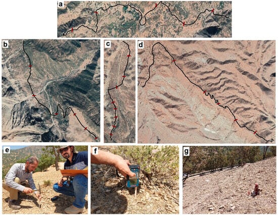
Figure 3.
The location of the benchmarks measurement along the (a) Nazi road, (b) Tabarak road, (c) Kohian road, (d) Bideleh road, (e) benchmark establishment, (f) measurements, and (g) identification in the field.
2.1.4. Model Validation and Assessment
In the present study, the SEDMODL model was validated using 13 erosion benchmarks located within 5 m of the study roads. The annual changes in erosion at these benchmark locations were measured and used to evaluate the model’s performance. The SEDMODL model was assessed using two key statistical parameters: the correlation coefficient (R) between the observed and estimated soil erosion values, as well as the root mean square error (RMSE).
2.1.5. Hotspot Analysis
Spatial statistics is a reliable method for investigating the behavior and distribution patterns of data. In this method, observations are not independent of each other but are instead dependent on their location in the study space [34]. The first step in spatial analysis is to identify the dispersion structure and hot spots of the data. In this research, we used the hot-spot analysis statistical method in GIS 10.8, which is specifically designed for analyzing numerical characteristics (such as the rate of soil erosion or sedimentation) or the weight of complications [8,35]). The resulting map shows areas with significant statistical characteristics, indicating hot and cold spots. Our analysis used Getis-ord GI statistics to identify areas with high erosion rates (hot spots of road erosion).
3. Results
In this study, a field survey was conducted to collect data along with basic maps, and the SEDMODL model equations were used to determine the required input factors as vector layers for each of the study road sections (Table 5). Figure 4, Figure 5, Figure 6 and Figure 7 display the input factors for the Nazi, Tabarak, Bideleh, and Kohian roads, respectively.
Table 5.
Specifications and characteristics of study road sections.
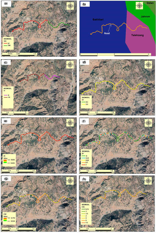
Figure 4.
Geological erosion rate factor GEr (a), geological formation map of the area (b), traffic factor Tf (c), road slope factor Gf (d), precipitation factor Pf (e), sediment delivery factor Df (f), vegetation and stone cover factor around the road CSf (g), and the excavation trench height factor Chf (h) for the Nazi study road.
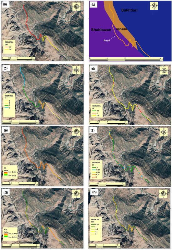
Figure 5.
Geological erosion rate factor GEr (a), geological formation map of the area (b), traffic factor Tf (c), road slope factor Gf (d), precipitation factor Pf (e), sediment delivery factor Df (f), vegetation and stone cover factor around the road CSf (g), and the excavation trench height factor Chf (h) for the Tabarak study road.
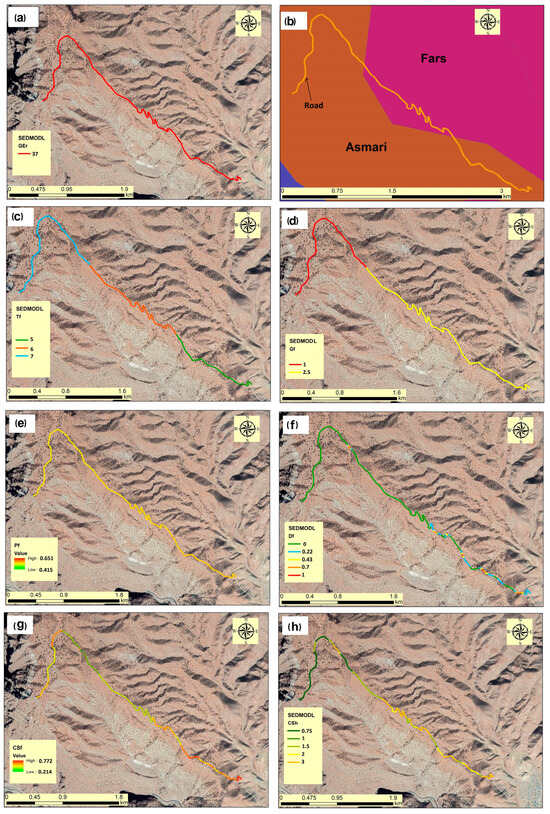
Figure 6.
Geological erosion rate factor GEr (a), geological formation map of the area (b), traffic factor Tf (c), road slope factor Gf (d), precipitation factor Pf (e), sediment delivery factor Df (f), vegetation and stone cover factor around the road CSf (g), and the excavation trench height factor Chf (h) for the Bideleh study road.
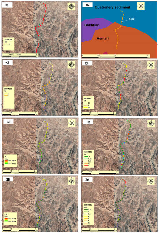
Figure 7.
Geological erosion rate factor GEr (a), geological formation map of the area (b), traffic factor Tf (c), road slope factor Gf (d), precipitation factor Pf (e), sediment delivery factor Df (f), vegetation and stone cover factor around the road CSf (g), and the excavation trench height factor Chf (h) for the Kohian study road.
Using the input factors prepared digitally for the model as well as the data collected from the study roads, the sedimentation of the road surface and the excavation trench were determined and extracted separately for the study road section (Table 6). Furthermore, the sedimentation and erosion of the entire study roads were determined using the SEDMODL and the equations presented in the study.
Table 6.
Total sediment yield estimation using SEDMODL for study roads.
The height changes of 144 benchmarks were recorded 6 times during one study year (2021–2022) in four study roads. The measurement results of erosion benchmarks indicated an average soil erosion of 3, 2.6, 4.7, and 3.5 mm per year around the Bideleh, Kohian, Nazi, and Tabarak roads, respectively.
3.1. Statistical Analysis
To assess the impact of input parameters on the erosion rates in SEDMODL, we conducted a Pearson correlation test, and the results are presented in Table 7. Our analysis indicated that the amount of road erosion is strongly correlated with geological factor (GEr), road width (W), and precipitation factor (Pf). These correlations are statistically significant.
Table 7.
Pearson correlation analysis results between total erosion and input factors in SEDMODL.
In this study, we measured soil erosion and sedimentation on both sides of forest roads at three distances (5, 15, and 25 m) from the road over the study year, using measuring benchmarks and laser measurements. The statistical analysis, using one-way ANOVA, revealed a significant difference in the height changes of the benchmarks at varying distances from the study roads, with a confidence level of 99% (Table 8).
Table 8.
Compare mean (one-way ANOVA) results of benchmark changes in different distances from forest roads.
Furthermore, Duncan’s grouping results indicated that there is no significant difference between the benchmarks at distances of 5 and 15 m from the study roads. By contrast, there is a significant difference between these two groups of data and the data collected at a distance of 25 m from the road (Figure 8).
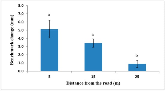
Figure 8.
Duncan’s grouping test for benchmark change in different distances from the forest roads (a and b show statistically different groups).
Moreover, the results of the paired t-test revealed that changes in the height of benchmarks measuring soil erosion and sedimentation at different distances from the forest road (5, 15, and 25 m) are subject to varying conditions. Specifically, the difference in erosion and deposition, and the changes in benchmarks at distances of 5 and 15 m from the road did not show a significant difference. However, the data from these two groups (5 and 15 m) differed significantly at the 99% confidence level from the data on benchmark height changes at a distance of 25 m from the forest road (Table 9).
Table 9.
Paired t-test results for benchmark change in different distances from forest roads.
3.2. Validation Analysis
The results of the SEDMODL validation analysis showed a correlation coefficient of 0.78 between the modeled and observed erosion values. Additionally, the RMSE was calculated to be 0.73 mm/year. This RMSE value indicates that on average, the model estimates differed from the observed erosion values by 0.73 mm/year. The relatively high correlation coefficient and low RMSE suggest the SEDMODL model was able to reasonably capture the soil loss patterns observed along the study roads. These validation metrics provide confidence in the model’s ability to estimate erosion rates for the road segments analyzed in this study.
3.3. Hot-Spot Analysis
Our analysis used Getis-ord GI statistics to identify areas with high erosion rates (hot spots of road erosion), as shown in Figure 9. In terms of erosion rates (based on SEDMODL), our results indicate that 30.8%, 22.6%, 39.8%, and 14.5% of the study forest roads, the Nazi, Tabarak, Bideleh, and Kohian roads, respectively, are identified as areas with very high erosion production and hot spots, with a confidence level above 95% (Table 10).
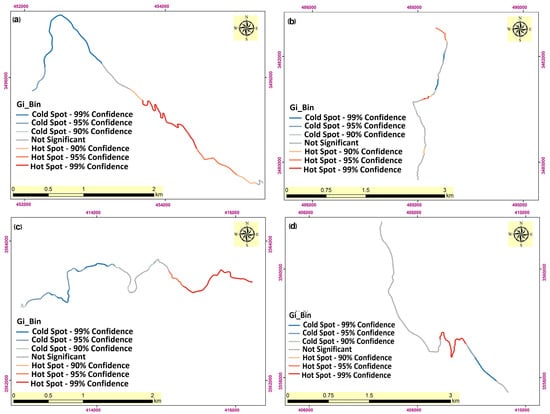
Figure 9.
Hot-spot analysis of soil erosion based on SEDMODL in (a) Bideleh, (b) Kohian, (c) Nazi, and (d) Tabarak forest roads.
Table 10.
Hot-spot analysis results in the study of forest roads.
4. Discussion
4.1. Soil Erosion and Sedimentation on Forest Roads
Forest roads, which are essential for timber harvesting, wildfire management, and recreational activities, can cause significant soil erosion and sedimentation, leading to environmental degradation and negative impacts on a forest ecosystem [36]. In Iran, the Zagros forestlands are an important ecosystem that play a crucial role in maintaining the ecological balance of the region and providing various ecosystem services [37]. The present study aimed to investigate the sedimentation and erosion of forest roads using SEDMODL, laser measurement, and benchmark monitoring in the Zagros forestlands, Iran. In the present study, four study forest roads in two counties in the Zagros Mountains were studied. The studied forest roads are different in terms of topography, climatic and environmental variables. Based on the SEDMODL results, the sediment yield of the study roads varies between 106.4 and 2947 tons per year, depending on the road segment. The erosion rates of the study roads were found to be strongly correlated with geological factors (GEr), road width (W), and precipitation factor (Pf), which is consistent with previous studies [38,39,40,41,42]. Geological factors, such as soil type, slope, and rock type, play a crucial role in the soil erosion process [43]. Finally, rock type can affect the erodibility of soil and determine the type and amount of sediment produced. Neglecting geological factors can lead to inaccurate erosion estimates and ineffective erosion control measures. Therefore, geological factors should be considered when designing and maintaining forest roads, agricultural lands, and other landscapes that are susceptible to soil erosion. Most parts of the Nazi forest road are located in an erodible geological formation [44,45,46], this geological formation is covered with Marl. Marls are a type of sedimentary rock that can have varying degrees of erodibility depending on their composition and structure [47,48,49]). Marls with high clay mineral content are generally more susceptible to erosion due to their low permeability and high water-holding capacity, which can increase the likelihood of soil saturation and reduce soil stability [50]. In addition, Marls with weak bedding planes or joints can be more prone to landslides and other forms of mass wasting. Strategies such as slope stabilization measures, vegetation management, and proper drainage systems can help mitigate the negative impacts of erodible Marls on soil erosion [32].
In the middle of the Tabarak road, the Aghajari geological formation appears. This part of the Tabarak road has a high rate of soil erosion (Figure 9). The Aghajari Formation, located on the slope of the Mishan Formation, is one of the most erodible formations in the Fars group (Aghajari, Mishan, and Gachsaran) located in the Zagros zone. The presence of gypsum Marls makes this formation highly susceptible to various types of erosion, including surface erosion, gullies, and mass movements. This vulnerability is exacerbated by the fact that the formation rests on top of Marl, sandstone, and silt, and in areas where these rocks are exposed to the surface, climatic conditions, particularly rainfall, can cause significant water erosion in the structure. In the Zagros zone, the formations of the Fars group are particularly vulnerable to soil erosion [51,52,53]. Our study found that in areas of the forest roads where the geological formations of the Fars Group are exposed, the level of soil erosion and changes in the height of wooden benchmarks used to measure soil erosion are higher. Therefore, it is important for designers and decision-makers to consider avoiding the formations of the Fars group as much as possible during the design and construction of forest roads to minimize land degradation and reduce the intensity of erosion.
Road width is an important factor that can significantly affect soil erosion and road destruction [22]. Narrow roads can cause concentrated flow and erosion, leading to gully formation, while wide roads can increase the surface area of the road and reduce the velocity of water, which can have more surface soil erosion [54,55,56,57,58,59]. Channelized erosion in the form of gullies and rills can be significantly more severe than diffuse surface erosion processes. However, wider roads may also cause increased disturbance to the surrounding ecosystem and increase the risk of road destruction due to landslides and other natural hazards. The width of the constructed roads may be one of the reasons for increased soil erosion on the Nazi and Tabarak roads. Our measurements indicate that the width of the Nazi and Tabarak roads is 6 and 5 m, respectively, which is wider than the Bideleh and Kohian roads. Therefore, when designing and maintaining forest roads, agricultural lands, and other landscapes that are susceptible to soil erosion, road width should be carefully considered to balance the trade-off between reducing erosion and maintaining road safety and ecological sustainability.
Precipitation is a critical factor that can significantly affect soil erosion on forest roads [3]. High-intensity rainfall events can cause significant soil erosion and sedimentation, leading to road damage and negative impacts on forest ecosystems. In addition, prolonged periods of rainfall can increase soil saturation and reduce soil stability, making it more susceptible to erosion [60,61]. Therefore, when designing and maintaining forest roads, precipitation patterns should be carefully considered to reduce erosion rates and prevent road damage. Strategies such as road drainage systems, slope stabilization measures, and vegetation management can help mitigate the negative impacts of precipitation on soil erosion on forest roads. In the present study, it was found that the amount of precipitation on the Nazi and Tabarak roads, located in Kuhrang County, was higher than that on the Bideleh and Kohian roads, located in Lordegan County.
4.2. Hot-Spot Analysis for Soil Erosion on Forest Roads
The identification of hot spots of erosion on forest roads can help prioritize erosion control measures and protect forest ecosystems [48]. The spatial analysis using the hot-spot analysis statistical method in GIS 10.8 software identified areas with high erosion rates (hot spots of the road in terms of erosion) in the Nazi, Tabarak, Bideleh, and Kohian roads. These results can be used to prioritize erosion control measures in these areas, which is consistent with previous studies that have also emphasized the importance of identifying hot-spots of erosion on forest roads [35,62]. Hot-spot analysis in the present study shows that the study roads located in erodible geological formations (Fars group) and high steep areas (Bideleh road) are more responsible for soil erosion and sediment production. Our findings suggest that these factors should be considered when designing and maintaining forest roads to reduce erosion rates. Land degradation can have different degrees and patterns at varying distances from roads in forest lands [8,55]. The immediate vicinity of roads, also known as the road prism, is often subject to the most severe degradation due to high-intensity traffic and the associated disturbances to the soil and vegetation [63]. This can lead to soil compaction, loss of topsoil, and reduction in vegetation cover, which can increase the susceptibility of the area to erosion and other forms of degradation. A statistical analysis using one-way ANOVA revealed a significant difference in the height changes of the benchmarks at varying distances from the study roads, with a confidence level of 99%. This is consistent with previous studies, which have also shown that the location of benchmark monitoring can significantly affect erosion and sedimentation measurements [26,32]. Results of the present study indicate that the amount of soil erosion around the forest roads has an indirect relationship with distance from the road. Typically, the most significant damage to vegetation and soil caused by forest roads occurs at a shorter distance from the road. In this zone, the destruction of vegetation reduces soil infiltration and increases the speed and volume of runoff during rainy events, leading to greater soil erosion along the roadside. Therefore, when designing and constructing forest roads, it is essential to minimize the destruction of vegetation along the road. After road construction, efforts should be made to improve growing conditions and restore vegetation, increase water infiltration, and reduce runoff. This is consistent with previous studies, which have also shown that the amount of soil erosion has an indirect relationship with distance from the forest roads [8]. However, land degradation can also occur at greater distances from roads due to the impacts of road runoff, sediment deposition, and changes in microclimate. For example, road runoff can transport pollutants and nutrients to nearby areas, affecting soil fertility and water quality. Sediment deposition can also alter the morphology and hydrology of nearby streams and water bodies, leading to further environmental degradation. Therefore, when designing and maintaining forest roads, it is important to consider the potential impacts on the surrounding environment at different distances from the road prism. Strategies such as adopting low-impact road construction techniques, implementing erosion control measures, and minimizing traffic volume and speed can help reduce the negative impacts of road construction and maintenance on land degradation in forest lands. During the early years of construction, forest roads experience the highest levels of runoff production and soil erosion due to the destruction of vegetation, soil compaction, and disturbance of geomorphological [32]. However, over time, as vegetation and the forest ecosystem recover, the impact on the roadside environment gradually diminishes, leading to more stable conditions for vegetation and soil [27]. Therefore, protecting the edge of forest roads during the early years of construction is critical. Furthermore, our observations and benchmark results indicate that in the recently constructed parts of the study forest roads (the western parts of the Nazi road and the northern parts of the Kohian road), there is higher soil destruction and erosion than in older parts of the road. The relatively low RMSE value, along with the high correlation coefficient, suggests the SEDMODL model was able to reasonably capture the soil loss patterns observed along the study roads. Our findings also highlight the usefulness of SEDMODL and empirical equations, combined with laser measurement and benchmark monitoring, in accurately estimating sediment yields on forest roads. This is consistent with previous studies that have also used SEDMODL and empirical equations to estimate sediment yields on forest roads [64,65,66,67]. However, it is important to note that the accuracy of our results is influenced by the quality and quantity of input data. Therefore, it is important to carefully choose the location of benchmarks to accurately monitor and estimate erosion rates on forest roads (Figure 8). The study results revealed that the areas of the study roads with the highest erosion and sediment production, as identified by the SEDMODL, also had the highest soil erosion levels according to the measurement benchmarks. This suggests that the SEDMODL can effectively identify hot spots of soil erosion along forest roads and be used as a model to predict soil erosion and sedimentation yield.
5. Conclusions
Forest ecosystems provide vital services, but forest roads can cause soil erosion and sedimentation, leading to environmental degradation. The Zagros forestlands in Iran are essential, but road construction has caused significant erosion, impacting the ecosystem and local communities. Measuring and monitoring erosion is critical to protect this important forest system. In this study, we investigated the sedimentation and erosion of forest roads using SEDMODL, empirical equations, laser measurement, and benchmark monitoring. Our findings revealed that erosion rates on forest roads are strongly correlated with geological factors, road width, and precipitation. Our analysis using one-way ANOVA and spatial analysis using a hot-spot analysis statistical method in GIS 10.8 software identified areas with high erosion rates (hot spots of road erosion) in the Nazi, Tabarak, Bideleh, and Kohian roads. These results can be used to prioritize erosion control measures in these areas. This study highlights the usefulness of SEDMODL and empirical equations, combined with laser measurement and benchmark monitoring, in accurately estimating sediment yields on forest roads. The model exhibited an R-squared value of 0.82 when validated against field-measured erosion rates, indicating a strong predictive capability. Furthermore, the mean error between modeled and observed sediment yields was only 12%, highlighting the reliability of this approach for quantifying erosion in this forest road environment. This can help design and maintain forest roads to reduce erosion rates and protect forest ecosystems. However, the accuracy of our results is influenced by the quality and quantity of input data. Therefore, future studies could focus on improving the accuracy of input data collection (DEM, geology layer, and vegetation cover) and analysis to further refine erosion modeling on forest roads. Moreover, statistical analysis suggests that the location of monitoring benchmarks can significantly affect erosion and sedimentation measurements. Therefore, future studies should carefully choose the location of benchmarks (distance from the road, cut slope and cut-fill area, road slope, etc.) to accurately monitor and estimate erosion rates on forest roads. The results of this study can be used by forest managers, engineers, and policymakers to design and maintain forest roads that are sustainable and environmentally friendly in the Zagros forestlands of Iran and other forest ecosystems around the world.
Overall, this study provides valuable insights into the sedimentation and erosion dynamics of forest roads in the Zagros region. The results highlight that key factors affecting the location and severity of erosion “hot spots” along the roads include: (A) Geological conditions, such as soil type and erodibility, that influence the susceptibility to gullying and other concentrated erosion forms. (B) Road width, where narrower sections tend to concentrate flow and increase erosion risk compared to wider road segments. (C) Precipitation patterns, as areas with higher rainfall amounts and intensities experience accelerated erosion processes.
These findings can inform the prioritization and design of targeted erosion control measures in problem areas. For example, in geologically sensitive zones or narrow road segments, specific engineering interventions like check dams, surface armoring, or improved cross-drainage could be implemented to disrupt concentrated flow and reduce erosion. Additionally, focusing maintenance and rehabilitation efforts in high-precipitation zones would help mitigate the impacts of increased water flow and erosive forces.
By identifying the key drivers of erosion hot spots, our results can guide forest managers, engineers, and policymakers in developing more sustainable and environmentally friendly forest road networks. Proactive erosion control strategies tailored to local conditions can help protect sensitive forest ecosystems and improve long-term road safety and functionality in the Zagros region and beyond.
Author Contributions
Conceptualization, S.Y. and S.N.E.; methodology, S.Y., M.N., O.R., F.I. and A.V.; software, S.Y., C.G. and M.N.; validation, S.Y., F.I. and C.G.; formal analysis, S.Y.; investigation, S.Y.; resources, S.Y. and S.N.E.; data curation, S.Y.; writing—original draft preparation, S.Y. and C.G.; writing—review and editing, S.Y.; visualization, S.Y. and A.V.; supervision, S.Y. All authors have read and agreed to the published version of the manuscript.
Funding
This study was funded by the Agricultural Research, Education and Extension Organization, AREEO, as part of Project No. 0-09-09-002-000095.
Data Availability Statement
The original contributions presented in the study are included in the article, further inquiries can be directed to the corresponding author.
Conflicts of Interest
The authors declare no conflicts of interest.
References
- Cheng, B.; Lv, Y.; Zhan, Y.; Su, D.; Cao, S. Constructing China’s roads as works of art: A case study of “Esthetic Greenway” construction in the shennongjia region of China. Land Degrad. Dev. 2015, 26, 324–330. [Google Scholar] [CrossRef]
- Chen, W.; Pourghasemi, H.R.; Kornejady, A.; Zhang, N. Landslide spatial modeling: Introducing new ensembles of ANN, MaxEnt, and SVM machine learning techniques. Geoderma 2017, 305, 314–327. [Google Scholar] [CrossRef]
- Sugden, B.D.; Woods, S.W. Sediment production from forest roads in western Montana. J. Am. Water Resour. Assoc. 2007, 43, 193–206. [Google Scholar] [CrossRef]
- Brown, K.R.; Mcguire, K.J.; Aust, W.M.; Hession, W.C.; Dolloff, C.A. The effect of increasing gravel cover on forest roads for reduced sediment delivery to stream crossings. Hydrol. Process. 2015, 29, 1129–1140. [Google Scholar] [CrossRef]
- Emami, S.N.; Yousefi, S.; Pourghasemi, H.R.; Tavangar, S.; Santosh, M. A comparative study on machine learning modeling for mass movement susceptibility mapping (a case study of Iran). Bull. Eng. Geol. Environ. 2020, 79, 5291–5308. [Google Scholar] [CrossRef]
- Haigh, M.J.; Rawat, J.S.; Rawat, M.S.; Bartarya, S.K.; Rai, S.P. Interactions between forest and landslide activity along new highways int he Kumaun Himalaya. For. Ecol. Manag. 1995, 78, 173–189. [Google Scholar] [CrossRef]
- Burroughs, E.R.; King, J.G. Reduction of soil erosion on forest roads. Gen. Tech. Rep. US Dep. Agric. For. Serv. 1989, 264, 1–19. [Google Scholar]
- Yousefi, S.; Moradi, H.; Boll, J.; Schönbrodt-Stitt, S. Effects of road construction on soil degradation and nutrient transport in Caspian Hyrcanian mixed forests. Geoderma 2016, 284, 103–112. [Google Scholar] [CrossRef]
- Fielding, J.A.H.; Hawks, B.S.; Aust, W.M.; Bolding, M.C.; Barrett, S.M. Estimated Erosion from Clearcut Timber Harvests in the Southeastern United States. For. Sci. 2022, 68, 334–342. [Google Scholar] [CrossRef]
- Vilar, L.; Gómez, I.; Martínez-Vega, J.; Echavarría, P.; Riaño, D.; Martín, M.P. Multitemporal modelling of socio-economic wildfire drivers in central Spain between the 1980s and the 2000s: Comparing generalized linear models to machine learning algorithms. PLoS ONE 2016, 11, e0161344. [Google Scholar] [CrossRef]
- Barber, C.P.; Cochrane, M.; Souza, C.M.; Laurance, W.F. Roads, deforestation, and the mitigating effect of protected areas in the Amazon. Biol. Conserv. 2014, 177, 203–209. [Google Scholar] [CrossRef]
- Parsakhoo, A.; Lotfalian, M.; Kavian, A.; Hosseini, S.A. Prediction of the soil erosion in a forest and sediment yield from road network through GIS and SEDMODL. Int. J. Sediment Res. 2014, 29, 118–125. [Google Scholar] [CrossRef]
- Habibzadeh, A.; Majidi, A. Estimating sediment yield from a forest road network using SEDMODEL and GIS technique (case study Arasbaran forests). ECOPERSIA 2021, 9, 235–249. [Google Scholar]
- Pardini, G.; Gispert, M.; Dunjó, G. Runoff erosion and nutrient depletion in five Mediterranean soils of NE Spain under different land use. Sci. Total Environ. 2023, 309, 213–224. [Google Scholar] [CrossRef] [PubMed]
- Rahmati, O.; Kalantari, Z.; Ferreira, C.S.; Chen, W.; Soleimanpour, S.M.; Kapović-Solomun, M. Contribution of physical and anthropogenic factors to gully erosion initiation. Catena 2022, 210, 105925. [Google Scholar] [CrossRef]
- Cao, L.; Elliot, W.; Long, J.W. Spatial simulation of forest road effects on hydrology and soil erosion after a wildfire. Hydrol. Process. 2021, 35, e14139. [Google Scholar] [CrossRef]
- Cao, L.; Wang, Y.; Liu, C. Study of unpaved road surface erosion based on terrestrial laser scanning. Catena 2021, 199, 105091. [Google Scholar] [CrossRef]
- Elliot, W.J.; Foltz, R.B.; Robichaud, P.R. Recent findings related to measuring and modeling forest road erosion. In Proceedings of the 18th World IMACS Congress and MODSIM International Congress on Modelling and Simulation: Interfacing Modelling and Simulation with Mathematical and Computational Sciences, Cairns, Australia, 13–17 July 2009; pp. 4078–4084. [Google Scholar]
- Akay, A.E.; Erdas, O.; Reis, M.; Yuksel, A. Estimating sediment yield from a forest road network by using a sediment prediction model and GIS techniques. Build. Environ. 2008, 43, 687–695. [Google Scholar] [CrossRef]
- Prendes, C.; Buján, S.; Ordoñez, C.; Canga, E. Large scale semi-automatic detection of forest roads from low density lidar data on steep terrain in Northern Spain. IForest 2019, 12, 366–374. [Google Scholar] [CrossRef]
- Zhao, Q.; Wang, A.; Jing, Y.; Zhang, G.; Yu, Z.; Yu, J.; Liu, Y.; Ding, S. Optimizing Management Practices to Reduce Sediment Connectivity between Forest Roads and Streams in a Mountainous Watershed. Remote Sens. 2022, 14, 4897. [Google Scholar] [CrossRef]
- Lei, G.; Yao, R.; Zhao, Y.; Zheng, Y. Detection and modeling of unstructured roads in forest areas based on visual-2D lidar data fusion. Forests 2021, 12, 820. [Google Scholar] [CrossRef]
- Kavian, A.; Safari, A.; Parsakhoo, A. Assessment of forest roads sediment yield using WARSEM, SEDMODL and direct measurement through rainfall simulation. J. Range Watershed Manag. 2016, 69, 167–186. [Google Scholar]
- Misirlioğlu, G.; Gümüş, S.; Yoshimura, T. Comparison of WEPP:Road Batch Model and ABAG Model for Estimating Amount of Top Soil Erosion in Forest Road Fill Slopes. Eur. J. For. Eng. 2022, 8, 26–34. [Google Scholar] [CrossRef]
- Yousefi, S.; Pourghasemi, H.R.; Emami, S.N.; Pouyan, S.; Eskandari, S.; Tiefenbacher, J.P. A machine learning framework for multi-hazards modeling and mapping in a mountainous area. Sci. Rep. 2020, 10, 12144. [Google Scholar] [CrossRef] [PubMed]
- Naghdi, R.; Dalir, P.; Gholami, V.; Pourghasemi, H.R. Modeling of sediment generation from forest roads employing SEDMODL and its calibration for Hyrcanian forests in northern Iran. Environ. Earth Sci. 2017, 76, 414. [Google Scholar] [CrossRef]
- Khandouzi, R.; Parsakhoo, A.; Sheikh, V.; Pourmalekshah, A.M. Effects of soil conservation practices on sediment yield from forest road ditches in northern Iran. Croat. J. For. Eng. 2020, 41, 299–308. [Google Scholar] [CrossRef]
- Conroy, W.J.; Dubé, K.V.; Koler, T.E. Comparison of methods to evaluate surface erosion from logging roads using watershed analyses. In Proceedings of the Watershed Management and Operations Management, Fort Collins, CO, USA, 20–24 June 2000; Volume 105, pp. 1–10. [Google Scholar] [CrossRef]
- Reid, L.M.; Dunne, T. Sediment production from forest road surfaces. Water Resour. Res. 1984, 20, 1753–1761. [Google Scholar] [CrossRef]
- Valjarević, A. Long-term remote sensing-based methods for monitoring air pollution and cloud cover in the Balkan countries. Environ. Sci. Pollut. Res. 2024, 31, 27155–27171. [Google Scholar] [CrossRef]
- Kramer, B.W. Forest Road Contracting, Construction, and Maintenance for Small Forest Woodland Owners; Oregon State University: Corvallis, OR, USA, 2001. [Google Scholar]
- Safari, A.; Kavian, A.; Parsakhoo, A. Assessment of effect of road or road construction on soil physical and chemical properties in northern forests of Iran. Int. J. Adv. Biol. Biomed. Res. 2013, 1, 835–850. [Google Scholar]
- Solgi, A.; Naghdi, R.; Zenner, E.K.; Hemmati, V.; Behjou, F.K.; Masumian, A. Evaluating the effectiveness of mulching for reducing soil erosion in cut slope and fill slope of forest roads in hyrcanian forests. Croat. J. For. Eng. 2021, 42, 259–268. [Google Scholar] [CrossRef]
- Stohlgren, T.J.; Barnett, D.; Flather, C.; Fuller, P.; Peterjohn, B.; Kartesz, J.; Master, L.L. Species richness and patterns of invasion in plants, birds, and fishes in the United States. Biol. Invasions 2006, 8, 427–447. [Google Scholar] [CrossRef]
- Yousefi, S.; Sadeghi, S.H.; Mirzaee, S.; Van Der Ploeg, M.; Keesstra, S.; Cerdà, A. Spatio-temporal variation of throughfall in a hyrcanian plain forest stand in Northern Iran. J. Hydrol. Hydromech. 2018, 66, 97–106. [Google Scholar] [CrossRef]
- Abbasi, E.; Hosseini, S.A.O.; Abdi, E.; Najafi, A. Environmental impact assessment of forest roads using the Goecybernetic Assessment Matrix (GAM): A case study from the Kheyrud forest, Iran. Iran. J. For. 2022, 13, 1–15. [Google Scholar]
- Haghighian, F.; Yousefi, S.; Keesstra, S. Identifying tree health using sentinel-2 images: A case study on Tortrix viridana L. infected oak trees in Western Iran. Geocarto Int. 2020, 37, 304–314. [Google Scholar] [CrossRef]
- Zhang, S.; Han, X.; Cruse, R.M.; Zhang, X.; Hu, W.; Yan, Y.; Guo, M. Morphological characteristics and influencing factors of permanent gully and its contribution to regional soil loss based on a field investigation of 393 km2 in Mollisols region of northeast China. Catena 2022, 217, 106467. [Google Scholar] [CrossRef]
- Chakrabortty, R.; Pal, S.C.; Sahana, M.; Mondal, A.; Dou, J.; Pham, B.T.; Yunus, A.P. Soil erosion potential hotspot zone identification using machine learning and statistical approaches in eastern India. Nat. Hazards 2020, 104, 1259–1294. [Google Scholar] [CrossRef]
- Pires, R.d.P.; Olofsson, K.; Persson, H.J.; Lindberg, E.; Holmgren, J. Individual tree detection and estimation of stem attributes with mobile laser scanning along boreal forest roads. ISPRS J. Photogramm. Remote Sens. 2022, 187, 211–224. [Google Scholar] [CrossRef]
- Bhagat, S.; Prasad, P.R.C. Assessing the impact of spatio-temporal land use and land cover changes on land surface temperature, with a major emphasis on mining activities in the state of Chhattisgarh, India. Spat. Inf. Res. 2023, 32, 339–355. [Google Scholar] [CrossRef]
- Al-Taei, A.I.; Alesheikh, A.A.; Boloorani, A.D. Evaluating the effects of land use/land cover change on the emergence of hazardous dust sources in the Tigris-Euphrates Basin. Spat. Inf. Res. 2024, 32, 569–582. [Google Scholar] [CrossRef]
- Jordán, A.; Martínez-Zavala, L. Soil loss and runoff rates on unpaved forest roads in southern Spain after simulated rainfall. For. Ecol. Manag. 2008, 255, 913–919. [Google Scholar] [CrossRef]
- Amiri, M.; Pourghasemi, H.R.; Ghanbarian, G.A.; Afzali, S.F. Assessment of the importance of gully erosion effective factors using Boruta algorithm and its spatial modeling and mapping using three machine learning algorithms. Geoderma 2019, 340, 55–69. [Google Scholar] [CrossRef]
- Arnáez, J.; Larrea, V.; Ortigosa, L. Surface runoff and soil erosion on unpaved forest roads from rainfall simulation tests in northeastern Spain. Catena 2004, 57, 1–14. [Google Scholar] [CrossRef]
- Valjarević, A.; Djekić, T.; Stevanović, V.; Ivanović, R.; Jandziković, B. GIS numerical and remote sensing analyses of forest changes in the Toplica region for the period of 1953–2013. Appl. Geogr. 2018, 92, 131–139. [Google Scholar] [CrossRef]
- Shahabi, H.; Amiri, Z.; Shirzadi, A. Prediction of Gully Erosion Susceptibility and Its Hazards in Kloche Bijar Watershed Using Spatial Predictive Models. Environ. Hazards. Manag. 2017, 9, 89–102. [Google Scholar] [CrossRef]
- Zhuang, Y.; Du, C.; Zhang, L.; Du, Y.; Li, S. Research trends and hotspots in soil erosion from 1932 to 2013: A literature review. Scientometrics 2015, 105, 743–758. [Google Scholar] [CrossRef]
- Kariminejad, N.; Hosseinalizadeh, M.; Pourghasemi, H.R.; Bernatek-Jakiel, A.; Campetella, G.; Ownegh, M. Evaluation of factors affecting gully headcut location using summary statistics and the maximum entropy model: Golestan Province, NE Iran. Sci. Total Environ. 2019, 677, 281–298. [Google Scholar] [CrossRef]
- Cherati, F.R.; Parsakhoo, A. Estimating Sediment Yield from Forest Road Surface using WARSEM Model (A Case Study: Darabkola Forest). Casp. J. Appl. Sci. Res. 2014, 3, 32–39. [Google Scholar]
- Clarke, M.A.; Walsh, R.P.D. Long-term erosion and surface roughness change of rain-forest terrain following selective logging, Danum Valley, Sabah, Malaysia. Catena 2006, 68, 109–123. [Google Scholar] [CrossRef]
- Dalir, P.; Naghdi, R.; Gholami, V. Assessing the rice straw effects on the soil erosion rate in forest road cut slope embankments. Casp. J. Environ. Sci. 2021, 19, 325–339. [Google Scholar] [CrossRef]
- Guo, L.; Liu, R.; Men, C.; Wang, Q.; Miao, Y.; Shoaib, M.; Wang, Y.; Jiao, L.; Zhang, Y. Multiscale spatiotemporal characteristics of landscape patterns, hotspots, and influencing factors for soil erosion. Sci. Total Environ. 2021, 779, 146474. [Google Scholar] [CrossRef]
- Kolka, R.K.; Smidt, M.F. Effects of forest road amelioration techniques on soil bulk density, surface runoff, sediment transport, soil moisture and seedling growth. For. Ecol. Manag. 2004, 202, 313–323. [Google Scholar] [CrossRef]
- Keesstra, S.; Mol, G.; de Leeuw, J.; Okx, J.; Molenaar, C.; de Cleen, M.; Visser, S. Soil-related sustainable development goals: Four concepts to make land degradation neutrality and restoration work. Land 2018, 7, 133. [Google Scholar] [CrossRef]
- Wang, C.; Liu, B.; Yang, Q.; Pang, G.; Long, Y.; Wang, L.; Cruse, R.M.; Dang, W.; Liu, X.; Wang, E. Unpaved road erosion after heavy storms in mountain areas of northern China. Int. Soil Water Conserv. Res. 2022, 10, 29–37. [Google Scholar] [CrossRef]
- Yousefi, S.; Avand, M.; Yariyan, P.; Pourghasemi, H.R.; Keesstra, S.; Tavangar, S.; Tabibian, S. A novel GIS-based ensemble technique for rangeland downward trend mapping as an ecological indicator change. Ecol. Indic. 2020, 117, 106591. [Google Scholar] [CrossRef]
- Yousefi, S.; Mirzaee, S.; Keesstra, S.; Surian, N.; Pourghasemi, H.R.; Zakizadeh, H.R.; Tabibian, S. Effects of an extreme flood on river morphology (case study: Karoon River, Iran). Geomorphology 2018, 304, 30–39. [Google Scholar] [CrossRef]
- Guo, W.; Bai, Y.; Cui, Z.; Wang, W.; Li, J.; Su, Z. The impact of concentrated flow and slope on unpaved loess-road erosion on the Chinese Loess Plateau. Land Degrad. Dev. 2021, 32, 914–925. [Google Scholar] [CrossRef]
- Mahdavi, A. Forests and rangelands? wildfire risk zoning using GIS and AHP techniques. Casp. J. Environ. Sci. 2012, 10, 43–52. [Google Scholar]
- Mohammady, M.; Pourghasemi, H.R.; Amiri, M. Land subsidence susceptibility assessment using random forest machine learning algorithm. Environ. Earth Sci. 2019, 78, 503. [Google Scholar] [CrossRef]
- Safari, A.; Kavian, A.; Parsakhoo, A.; Saleh, I.; Jordán, A. Impact of different parts of skid trails on runoff and soil erosion in the Hyrcanian forest (northern Iran). Geoderma 2016, 263, 161–167. [Google Scholar] [CrossRef]
- Rahmati, O.; Yousefi, S.; Kalantari, Z.; Uuemaa, E.; Teimurian, T.; Keesstra, S.; Pham, T.D.; Bui, D.T. Multi-hazard exposure mapping using machine learning techniques: A case study from Iran. Remote Sens. 2019, 11, 1943. [Google Scholar] [CrossRef]
- Seutloali, K.E.; Beckedahl, H.R. A review of road-related soil erosion: An assessment of causes. Earth Sci. Res. J. 2015, 19, 73–80. [Google Scholar] [CrossRef]
- Zhao, Q.; Wang, A.; Yu, Z.; Yu, J.; Liu, Y.; Zhang, G.; Liu, G.; Wang, P.; Ding, S. Factors contributing to rill erosion of forest roads in a mountainous watershed. J. Environ. Manag. 2023, 326, 116829. [Google Scholar] [CrossRef] [PubMed]
- Yi, M.; Yan, Q.; Li, K.; Ma, X.; Li, G.; Wu, Z.; Pan, Q.; Chen, X. The Ecological Environmental Effects and Topographic Gradient Analysis of Transformation in the Production–Living–Ecological Spaces in the Northern Slope of the Tianshan Mountains. Land 2024, 13, 1170. [Google Scholar] [CrossRef]
- Valjarević, A. GIS-Based Methods for Identifying River Networks Types and Changing River Basins. Water Resour. Manag. 2024, 17, 1–19. [Google Scholar] [CrossRef]
Disclaimer/Publisher’s Note: The statements, opinions and data contained in all publications are solely those of the individual author(s) and contributor(s) and not of MDPI and/or the editor(s). MDPI and/or the editor(s) disclaim responsibility for any injury to people or property resulting from any ideas, methods, instructions or products referred to in the content. |
© 2024 by the authors. Licensee MDPI, Basel, Switzerland. This article is an open access article distributed under the terms and conditions of the Creative Commons Attribution (CC BY) license (https://creativecommons.org/licenses/by/4.0/).