
Assessing the Cumulative Impacts of Forest Management on Forest Age Structure Development and Woodland Caribou Habitat in Boreal Landscapes: A Case Study from Two Canadian Provinces

 ,
,  , ,
, ,  ,
,
Abstract
:1. Introduction
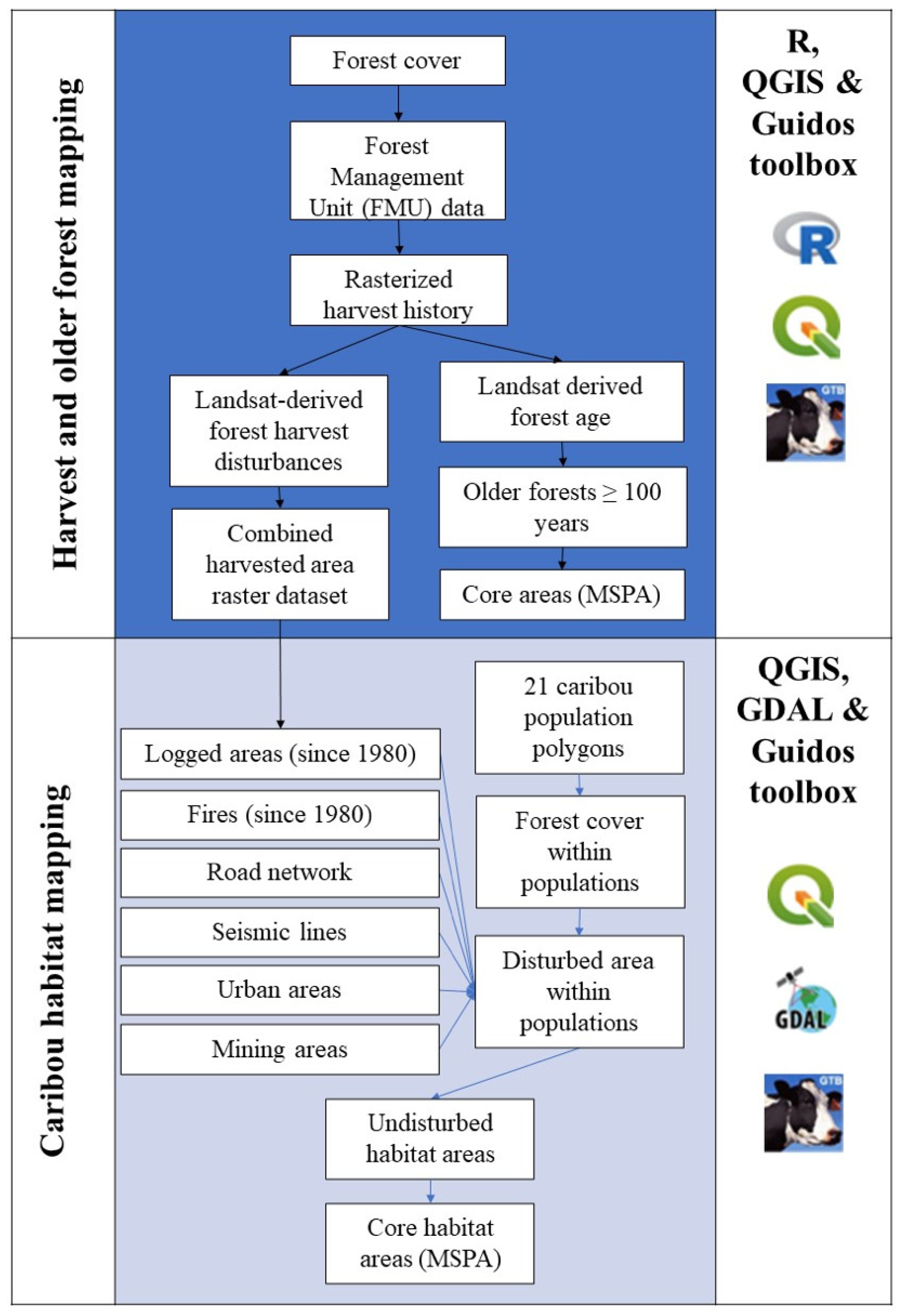
2. Materials and Methods
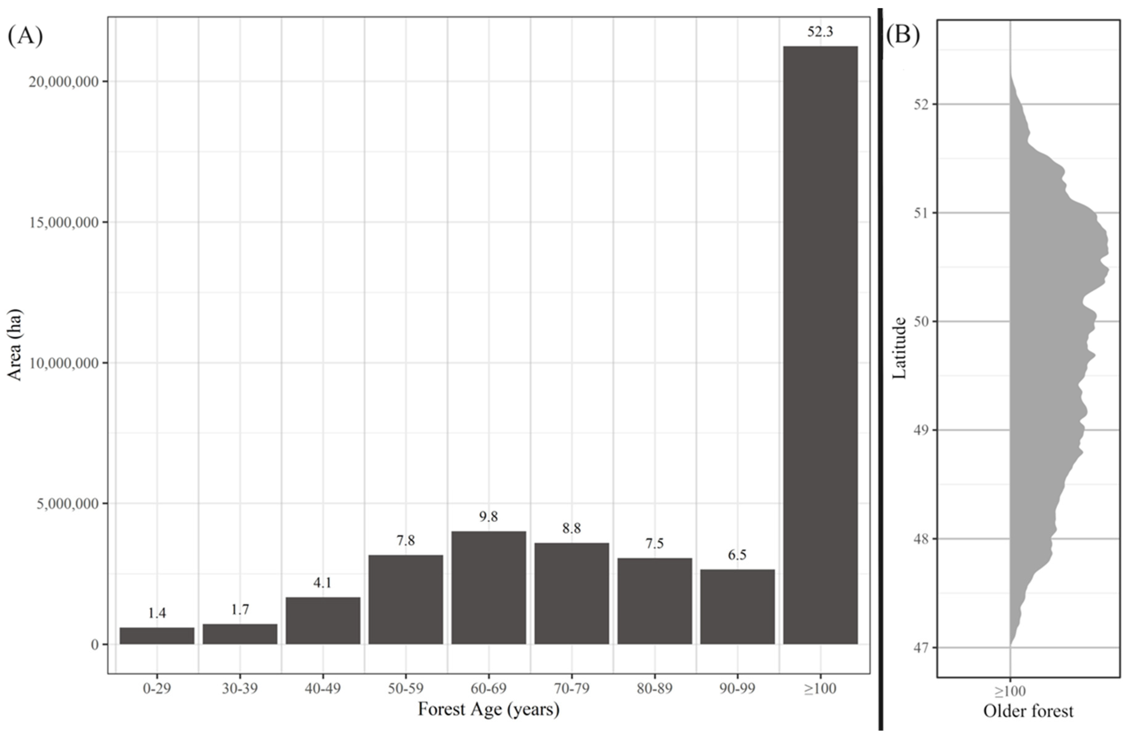
3. Results
4. Discussion
4.1. Caribou Habitat
4.2. Forest Degradation
5. Conclusions
Supplementary Materials
Author Contributions
Funding
Data Availability Statement
Conflicts of Interest
References
- Rogers, B.M.; Mackey, B.; Shestakova, T.A.; Keith, H.; Young, V.; Kormos, C.F.; DellaSala, D.A.; Dean, J.; Birdsey, R.; Bush, G.; et al. Using ecosystem integrity to maximize climate mitigation and minimize risk in international forest policy. Front. For. Glob. Chang. 2022, 5, 929281. [Google Scholar] [CrossRef]
- Wei, X.; Giles-Hansen, K.; Spencer, S.A.; Ge, X.; Onuchin, A.; Li, Q.; Burenina, T.; Ilintsev, A.; Hou, Y. Forest harvesting and hydrology in boreal Forests: Under an increased and cumulative disturbance context. For. Ecol. Manag. 2022, 522, 120468. [Google Scholar] [CrossRef]
- Lorås, J.; Eidissen, S.E. What the “seven-flitch log” may tell us. Changes in the boreal forest ecology over the past 500 years. Blyttia 2019, 77, 81–94. [Google Scholar]
- Bouderbala, I.; Labadie, G.; Béland, J.-M.; Tremblay, J.A.; Boulanger, Y.; Hébert, C.; Desrosiers, P.; Allard, A.; Fortin, D. Long-term effect of forest harvesting on boreal species assemblages under climate change. PLoS Clim. 2023, 2, e0000179. [Google Scholar] [CrossRef]
- Drapeau, P.; Villard, M.-A.; Leduc, A.; Hannon, S.J. Natural disturbance regimes as templates for the response of bird species assemblages to contemporary forest management. Divers. Distrib. 2016, 22, 385–399. [Google Scholar] [CrossRef]
- Muurinen, L.; Oksanen, J.; Vanha-Majamaa, I.; Virtanen, R. Legacy effects of logging on boreal forest understorey vegetation communities in decadal time scales in northern Finland. For. Ecol. Manag. 2019, 436, 11–20. [Google Scholar] [CrossRef]
- Boucher, Y.; Auger, I.; Arseneault, D.; Elzein, T.; Sirois, L. Long-term (1925–2015) forest structure reorganization in an actively managed temperate-boreal forest region of eastern North America. For. Ecol. Manag. 2021, 481, 118744. [Google Scholar] [CrossRef]
- Longo, M.; Saatchi, S.; Keller, M.; Bowman, K.; Ferraz, A.; Moorcroft, P.R.; Morton, D.C.; Bonal, D.; Brando, P.; Burban, B.; et al. Impacts of Degradation on Water, Energy, and Carbon Cycling of the Amazon Tropical Forests. J. Geophys. Res. Biogeosci. 2020, 125, e2020JG005677. [Google Scholar] [CrossRef]
- Bradshaw, C.J.A.; Warkentin, I.G.; Sodhi, N.S. Urgent preservation of boreal carbon stocks and biodiversity. Trends Ecol. Evol. 2009, 24, 541–548. [Google Scholar] [CrossRef]
- Gauthier, S.; Vaillancourt, M.-A.; Leduc, A.; De Grandpré, L.; Kneeshaw, D.D.; Morin, H.; Drapeau, P.; Bergeron, Y. (Eds.) Ecosystem Management in the Boreal Forest; Presses de l’Université du Québec: Québec, QC, Canada, 2009. [Google Scholar]
- Anyomi, K.A.; Neary, B.; Chen, J.; Mayor, S.J. A critical review of successional dynamics in boreal forests of North America. Environ. Rev. 2022, 30, 563–594. [Google Scholar] [CrossRef]
- Brandt, J.P.; Flannigan, M.D.; Maynard, D.G.; Thompson, I.D.; Volney, W.J.A. An introduction to Canada’s boreal zone: Ecosystem processes, health, sustainability, and environmental issues. Environ. Rev. 2013, 21, 207–226. [Google Scholar] [CrossRef]
- Bergeron, Y.; Fenton, N.J. Boreal forests of eastern Canada revisited: Old growth, nonfire disturbances, forest succession, and biodiversity. Botany 2012, 90, 509–523. [Google Scholar] [CrossRef]
- Harper, K.A.; Bergeron, Y.; Drapeau, P.; Gauthier, S.; De Grandpré, L. Structural development following fire in black spruce boreal forest. For. Ecol. Manag. 2005, 206, 293–306. [Google Scholar] [CrossRef]
- OMNR. Emulating Natural Disturbances: Cleacut silviculture in Ontario; Ministry of Natural Resources: Ontario, ON, Canada, 2013.
- Bergeron, Y.; Drapeau, P.; Gauthier, S.; Lecomte, N. Using knowledge of natural disturbances to support sustainable forest management in the northern Clay Belt. For. Chron. 2007, 83, 326–337. [Google Scholar] [CrossRef]
- Bergeron, Y.; Leduc, A.; Harvey, B.D.; Gauthier, S. Natural fire regime: A guide for sustainable management of the Canadian boreal forest. Silva Fenn. 2002, 36, 81–95. [Google Scholar] [CrossRef]
- Boucher, Y.; Arseneault, D.; Sirois, L.; Blais, L. Logging pattern and landscape changes over the last century at the boreal and deciduous forest transition in Eastern Canada. Landsc. Ecol. 2009, 24, 171–184. [Google Scholar] [CrossRef]
- Gauthier, S.; Bernier, P.; Kuuluvainen, T.; Shvidenko, A.Z.; Schepaschenko, D.G. Boreal forest health and global change. Science 2015, 349, 819–822. [Google Scholar] [CrossRef]
- Drapeau, P.; Nappi, A.; Imbeau, L.; Saint-Germain, M. Standing deadwood for keystone bird species in the eastern boreal forest: Managing for snag dynamics. For. Chron. 2009, 85, 227–234. [Google Scholar] [CrossRef]
- Drapeau, P.; Leduc, A.; Bergeron, Y. Bridging Ecosystem and Multiple Species Approaches for Setting Conservation Targets in Managed Boreal Landscapes. In Setting Conservation Targets for Managed Forest landscapes; Villard, M., Jonsson, B.G., Eds.; Cambridge University Press: Cambridge, UK, 2009; pp. 129–160. [Google Scholar]
- Environment Canada. Scientific Assessment to Inform the Identification of Critical Habitat for Woodland Caribou, Boreal Population, in Canada—2011 Update: Introduction; Environment Canada: Ontario, ON, Canada, 2011; Available online: https://www.canada.ca/en/environment-climate-change/services/species-risk-public-registry/related-information/scientific-assessment-critical-habitat-woodland-caribou-boreal-2011-sec1.html (accessed on 23 April 2023).
- Hill, D.; Simpson-Marran, M.; Gould, L.; Nason, S. Status of Boreal Woodland Caribou Conservation in Canada: A Summary of Range Planning, Restoration, and Opportunities to Win on Caribou and Climate; The Pembina Institute: Calgary, AB, Canada, 2021. [Google Scholar]
- COSEWIC. OSEWIC Assessment and Status Report on the Caribou Rangifer tarandus, Newfoundland Population, Atlantic-Gaspésie Population, Boreal Population in Canada—2014; Government of Canada: Ottawa, ON, Canada, 2014.
- Festa-Bianchet, M.; Ray, J.C.; Boutin, S.; Côté, S.D.; Gunn, A. Conservation of caribou (Rangifer tarandus) in Canada: An uncertain future1This review is part of the virtual symposium “Flagship Species – Flagship Problems” that deals with ecology, biodiversity and management issues, and climate impacts on species at risk and of Canadian importance, including the polar bear (Ursus maritimus), Atlantic cod (Gadus morhua), Piping Plover (Charadrius melodus), and caribou (Rangifer tarandus). Can. J. Zool. 2011, 89, 419–434. [Google Scholar] [CrossRef]
- Schaefer, J.A. Long-Term Range Recession and the Persistence of Caribou in the Taiga. Conserv. Biol. 2003, 17, 1435–1439. [Google Scholar] [CrossRef]
- Dyer, S.J.; O’Neill, J.P.; Wasel, S.M.; Boutin, S. Avoidance of Industrial Development by Woodland Caribou. J. Wildl. Manag. 2001, 65, 531–542. [Google Scholar] [CrossRef]
- Muhly, T.; Serrouya, R.; Neilson, E.; Li, H.; Boutin, S. Influence of In-Situ Oil Sands Development on Caribou (Rangifer tarandus) Movement. PLoS ONE 2015, 10, e0136933. [Google Scholar] [CrossRef] [PubMed]
- Polfus, J.L.; Hebblewhite, M.; Heinemeyer, K. Identifying indirect habitat loss and avoidance of human infrastructure by northern mountain woodland caribou. Biol. Conserv. 2011, 144, 2637–2646. [Google Scholar] [CrossRef]
- Skarin, A.; Nellemann, C.; Rönnegård, L.; Sandström, P.; Lundqvist, H. Wind farm construction impacts reindeer migration and movement corridors. Landsc. Ecol. 2015, 30, 1527–1540. [Google Scholar] [CrossRef]
- Weir, J.N.; Mahoney, S.P.; McLaren, B.; Ferguson, S.H. Effects of Mine Development on Woodland Caribou Rangifer tarandus Distribution. Wildl. Biol. 2007, 13, 66–74. [Google Scholar] [CrossRef]
- Dickie, M.; Serrouya, R.; DeMars, C.; Cranston, J.; Boutin, S. Evaluating functional recovery of habitat for threatened woodland caribou. Ecosphere 2017, 8, e01936. [Google Scholar] [CrossRef]
- Mumma, M.A.; Gillingham, M.P.; Johnson, C.J.; Parker, K.L. Functional responses to anthropogenic linear features in a complex predator-multi-prey system. Landsc. Ecol. 2019, 34, 2575–2597. [Google Scholar] [CrossRef]
- Mumma, M.A.; Gillingham, M.P.; Parker, K.L.; Johnson, C.J.; Watters, M. Predation risk for boreal woodland caribou in human-modified landscapes: Evidence of wolf spatial responses independent of apparent competition. Biol. Conserv. 2018, 228, 215–223. [Google Scholar] [CrossRef]
- Fortin, D.; Buono, P.-L.; Schmitz, O.J.; Courbin, N.; Losier, C.; St-Laurent, M.-H.; Drapeau, P.; Heppell, S.; Dussault, C.; Brodeur, V.; et al. A spatial theory for characterizing predator–multiprey interactions in heterogeneous landscapes. Proc. R. Soc. B Biol. Sci. 2015, 282, 20150973. [Google Scholar] [CrossRef]
- Hins, C.; Ouellet, J.-P.; Dussault, C.; St-Laurent, M.-H. Habitat selection by forest-dwelling caribou in managed boreal forest of eastern Canada: Evidence of a landscape configuration effect. For. Ecol. Manag. 2009, 257, 636–643. [Google Scholar] [CrossRef]
- Leclerc, M.; Dussault, C.; St-Laurent, M.-H. Multiscale assessment of the impacts of roads and cutovers on calving site selection in woodland caribou. For. Ecol. Manag. 2012, 286, 59–65. [Google Scholar] [CrossRef]
- Vors, L.S.; Schaefer, J.A.; Pond, B.A.; Rodgers, A.R.; Patterson, B.R. Woodland Caribou Extirpation and Anthropogenic Landscape Disturbance in Ontario. J. Wildl. Manag. 2007, 71, 1249–1256. [Google Scholar] [CrossRef]
- Dussault, C.; Pinard, V.; Ouellet, J.-P.; Courtois, R.; Fortin, D. Avoidance of roads and selection for recent cutovers by threatened caribou: Fitness-rewarding or maladaptive behaviour? Proc. R. Soc. B Biol. Sci. 2012, 279, 4481–4488. [Google Scholar] [CrossRef] [PubMed]
- Leblond, M.; Dussault, C.; Ouellet, J.-P. Avoidance of roads by large herbivores and its relation to disturbance intensity. J. Zool. 2013, 289, 32–40. [Google Scholar] [CrossRef]
- Leblond, M.; Dussault, C.; Ouellet, J.-P. Impacts of Human Disturbance on Large Prey Species: Do Behavioral Reactions Translate to Fitness Consequences? PLoS ONE 2013, 8, e73695. [Google Scholar] [CrossRef] [PubMed]
- Rudolph, T.D.; Drapeau, P.; Imbeau, L.; Brodeur, V.; Légaré, S.; St-Laurent, M.-H. Demographic responses of boreal caribou to cumulative disturbances highlight elasticity of range-specific tolerance thresholds. Biodivers. Conserv. 2017, 26, 1179–1198. [Google Scholar] [CrossRef]
- Rudolph, T.D.; Drapeau, P.; St-Laurent, M.; Imbeau, L. Status of Woodland Caribou (Rangifer tarandus Caribou) in the James Bay Region of Northern Quebec. Scientific Report Presented to the Ministère des Ressources Naturelles et de la Faune du Québec and the Grand Council of the Crees (Eeyou Istchee); Ministère des Ressources Naturelles et de la Faune du Québec and the Grand Council of the Crees (Eeyou Istchee): Montreal, QC, Canada, 2012.
- St-Pierre, F.; Drapeau, P.; St-Laurent, M.-H. Stairway to heaven or highway to hell? How characteristics of forest roads shape their use by large mammals in the boreal forest. For. Ecol. Manag. 2022, 510, 120108. [Google Scholar] [CrossRef]
- Jobidon, R.; Bergeron, Y.; Robitaille, A.; Raulier, F.; Gauthier, S.; Imbeau, L.; Saucier, J.-P.; Boudreault, C. A biophysical approach to delineate a northern limit to commercial forestry: The case of Quebec’s boreal forest. Can. J. For. Res. 2015, 45, 515–528. [Google Scholar] [CrossRef]
- Forêts, Faune et Parcs Quebec. MFFP—Espèces Fauniques Menacées ou Vulnérables au Québec—Caribou des Bois, Écotype Forestier; Forêts, Faune et Parcs Quebec: Quebec, QC, Canada, 2022. Available online: https://www3.mffp.gouv.qc.ca/faune/especes/menacees/fiche.asp?noEsp=53 (accessed on 14 June 2023).
- Land Information Ontario. Caribou Range Boundary; Land Information Ontario: Ontario, ON, Canada, 2019. Available online: https://geohub.lio.gov.on.ca/datasets/lio::caribou-range-boundary/about (accessed on 14 June 2023).
- Hermosilla, T.; Wulder, M.A.; White, J.C.; Coops, N.C. Land cover classification in an era of big and open data: Optimizing localized implementation and training data selection to improve mapping outcomes. Remote Sens. Environ. 2022, 268, 112780. [Google Scholar] [CrossRef]
- Hermosilla, T.; Wulder, M.A.; White, J.C.; Coops, N.C.; Hobart, G.W. Disturbance-Informed Annual Land Cover Classification Maps of Canada’s Forested Ecosystems for a 29-Year Landsat Time Series. Can. J. Remote Sens. 2018, 44, 67–87. [Google Scholar] [CrossRef]
- Hijmans, R.J. Terra: Spatial Data Analysis; The Comprehensive R Archive Network: Ontario, ON, Canada, 2022. [Google Scholar]
- R Core Team. R: A Language and Environment for Statistical Computing; R Core Team: Vienna, Austria, 2023. [Google Scholar]
- QGIS Development Team. QGIS Geographic Information System; QGIS Development Team: Rimouski, QC, Canada, 2023. [Google Scholar]
- Land Information Ontario. Forest Resources Inventory Packaged Products—Version 2; Land Information Ontario: Ontario, ON, Canada, 2022. Available online: https://geohub.lio.gov.on.ca/maps/lio::forest-resources-inventory-packaged-products-version-2/about (accessed on 4 April 2023).
- Ministère des Ressources Naturelles et des Forêts. Unité D’Aménagement (UA)—Données Québec; Ministère des Ressources Naturelles et des Forêts: Québec, QU, Canada, 2023. Available online: https://www.donneesquebec.ca/recherche/dataset/unite-d-amenagement (accessed on 18 April 2023).
- Ministère des Ressources Naturelles et des Forêts. Récolte et Autres Interventions Sylvicoles—Données Québec; Ministère des Ressources Naturelles et des Forêts: Québec, QU, Canada, 2023. Available online: https://www.donneesquebec.ca/recherche/dataset/recolte-et-reboisement (accessed on 4 April 2023).
- Hermosilla, T.; Wulder, M.A.; White, J.C.; Coops, N.C.; Hobart, G.W.; Campbell, L.B. Mass data processing of time series Landsat imagery: Pixels to data products for forest monitoring. Int. J. Digit. Earth 2016, 9, 1035–1054. [Google Scholar] [CrossRef]
- Land Information Ontario. Ontario Land Cover Compilation v.2.0; Land Information Ontario: Ontario, ON, Canada, 2022. Available online: https://geohub.lio.gov.on.ca/documents/7aa998fdf100434da27a41f1c637382c (accessed on 13 April 2023).
- Ministère de l’Environnement. Utilisation du Territoire—Données Québec; Ministère de l’Environnement: Québec, QU, Canada, 2023. Available online: https://www.donneesquebec.ca/recherche/dataset/utilisation-du-territoire (accessed on 13 April 2023).
- Ministère des Ressources Naturelles et des Forêts. Carte Écoforestière à Jour—Données Québec; Ministère des Ressources Naturelles et des Forêts: Québec, QU, Canada, 2022. Available online: https://www.donneesquebec.ca/recherche/dataset/carte-ecoforestiere-avec-perturbations# (accessed on 15 June 2023).
- Maltman, J.C.; Hermosilla, T.; Wulder, M.A.; Coops, N.C.; White, J.C. Estimating and mapping forest age across Canada’s forested ecosystems. Remote Sens. Environ. 2023, 290, 113529. [Google Scholar] [CrossRef]
- Soille, P.; Vogt, P. Morphological segmentation of binary patterns. Pattern Recognit. Lett. 2009, 30, 456–459. [Google Scholar] [CrossRef]
- Vogt, P.; Riitters, K. GuidosToolbox: Universal digital image object analysis. Eur. J. Remote Sens. 2017, 50, 352–361. [Google Scholar] [CrossRef]
- Lesmerises, R.; Ouellet, J.-P.; Dussault, C.; St-Laurent, M.-H. The influence of landscape matrix on isolated patch use by wide-ranging animals: Conservation lessons for woodland caribou. Ecol. Evol. 2013, 3, 2880–2891. [Google Scholar] [CrossRef]
- Bergqvist, G.; Wallgren, M.; Jernelid, H.; Bergström, R. Forage availability and moose winter browsing in forest landscapes. For. Ecol. Manag. 2018, 419–420, 170–178. [Google Scholar] [CrossRef]
- Seip, D.R. Factors limiting woodland caribou populations and their interrelationships with wolves and moose in southeastern British Columbia. Can. J. Zool. 1992, 70, 1494–1503. [Google Scholar] [CrossRef]
- Wittmer, H.U.; McLellan, B.N.; Serrouya, R.; Apps, C.D. Changes in landscape composition influence the decline of a threatened woodland caribou population. J. Anim. Ecol. 2007, 76, 568–579. [Google Scholar] [CrossRef]
- Leclerc, M.; Dussault, C.; St-Laurent, M.-H. Behavioural strategies towards human disturbances explain individual performance in woodland caribou. Oecologia 2014, 176, 297–306. [Google Scholar] [CrossRef]
- Lesmerises, F.; Dussault, C.; St-Laurent, M.-H. Wolf habitat selection is shaped by human activities in a highly managed boreal forest. For. Ecol. Manag. 2012, 276, 125–131. [Google Scholar] [CrossRef]
- Whittington, J.; Hebblewhite, M.; DeCesare, N.J.; Neufeld, L.; Bradley, M.; Wilmshurst, J.; Musiani, M. Caribou encounters with wolves increase near roads and trails: A time-to-event approach. J. Appl. Ecol. 2011, 48, 1535–1542. [Google Scholar] [CrossRef]
- Losier, C.L.; Couturier, S.; St-Laurent, M.-H.; Drapeau, P.; Dussault, C.; Rudolph, T.; Brodeur, V.; Merkle, J.A.; Fortin, D. Adjustments in habitat selection to changing availability induce fitness costs for a threatened ungulate. J. Appl. Ecol. 2015, 52, 496–504. [Google Scholar] [CrossRef]
- Elkie, P.; Green, K.; Racey, G.; Gluck, M.; Elliot, J.; Hooper, G.; Kushneriuk, R.; Rempel, R. Science and Information in Support of Policies That Address the Conservation of Woodland Caribou in Ontario 2018; Ministry of the Environment, Conservation and Parks: Ontario, ON, Canada, 2018. Available online: https://www.ontario.ca/page/range-management-policy-support-woodland-caribou-conservation-and-recovery (accessed on 17 April 2023).
- Land Information Ontario. MNRF Road Segments; Land Information Ontario: Ontario, ON, Canada, 2020. Available online: https://geohub.lio.gov.on.ca/datasets/lio::mnrf-road-segments/explore (accessed on 17 April 2023).
- Statistics Canada. National Road Network—NRN—GeoBase Series—Open Government Portal; Statistics Canada: Ottawa, ON, Canada, 2022. Available online: https://open.canada.ca/data/en/dataset/3d282116-e556-400c-9306-ca1a3cada77f (accessed on 17 April 2023).
- Natural Resources Canada. Canadian Wildland Fire Information System|Download Data; Natural Resources Canada: Calgary, AB, Canada, 2021. Available online: https://cwfis.cfs.nrcan.gc.ca/datamart/download/nfdbpoly (accessed on 17 April 2023).
- Wynne, G.; James-Abra, E. Timber Trade History. In The Canadian Encyclopedia; Historica Canada: Toronto, ON, Canada, 2015; Available online: https://www.thecanadianencyclopedia.ca/en/article/timber-trade-history (accessed on 21 August 2023).
- Thorn, S.; Bässler, C.; Brandl, R.; Burton, P.J.; Cahall, R.; Campbell, J.L.; Castro, J.; Choi, C.-Y.; Cobb, T.; Donato, D.C.; et al. Impacts of salvage logging on biodiversity: A meta-analysis. J. Appl. Ecol. 2018, 55, 279–289. [Google Scholar] [CrossRef]
- FAO. Global Forest Resources Assessment 2020: Terms and Definitions FRA 2020; Food and Agricultural Organization of the United Nations: Rome, Italy, 2020. [Google Scholar]
- Antonarakis, A.S.; Pacca, L.; Antoniades, A. The effect of financial crises on deforestation: A global and regional panel data analysis. Sustain. Sci. 2022, 17, 1037–1057. [Google Scholar] [CrossRef]
- St-Laurent, M.-H.; Boulanger, Y.; Cyr, D.; Manka, F.; Drapeau, P.; Gauthier, S. Lowering the rate of timber harvesting to mitigate impacts of climate change on boreal caribou habitat quality in eastern Canada. Sci. Total Environ. 2022, 838, 156244. [Google Scholar] [CrossRef]
- Nagy-Reis, M.; Dickie, M.; Calvert, A.M.; Hebblewhite, M.; Hervieux, D.; Seip, D.R.; Gilbert, S.L.; Venter, O.; DeMars, C.; Boutin, S.; et al. Habitat loss accelerates for the endangered woodland caribou in western Canada. Conserv. Sci. Pract. 2021, 3, e437. [Google Scholar] [CrossRef]
- DellaSala, D.A.; Strittholt, J.R.; Degagne, R.; Mackey, B.; Werner, J.R.; Connolly, M.; Coxson, D.; Couturier, A.; Keith, H. Red-Listed Ecosystem Status of Interior Wetbelt and Inland Temperate Rainforest of British Columbia, Canada. Land 2021, 10, 775. [Google Scholar] [CrossRef]
- Cyr, D.; Gauthier, S.; Bergeron, Y.; Carcaillet, C. Forest management is driving the eastern North American boreal forest outside its natural range of variability. Front. Ecol. Environ. 2009, 7, 519–524. [Google Scholar] [CrossRef]
- Bergeron, Y.; Cyr, D.; Drever, C.R.; Flannigan, M.; Gauthier, S.; Kneeshaw, D.; Lauzon, È.; Leduc, A.; Le Goff, H.; Lesieur, D.; et al. Past, current, and future fire frequencies in Quebec’s commercial forests: Implications for the cumulative effects of harvesting and fire on age-class structure and natural disturbance-based management. Can. J. For. Res. 2006, 36, 2737–2744. [Google Scholar] [CrossRef]
- Bergeron, Y.; Gauthier, S.; Flannigan, M.; Kafka, V. Fire Regimes at the Transition between Mixedwood and Coniferous Boreal Forest in Northwestern Quebec. Ecology 2004, 85, 1916–1932. [Google Scholar] [CrossRef]
- Boucher, Y.; Perrault-Hébert, M.; Fournier, R.; Drapeau, P.; Auger, I. Cumulative patterns of logging and fire (1940–2009): Consequences on the structure of the eastern Canadian boreal forest. Landsc. Ecol. 2017, 32, 361–375. [Google Scholar] [CrossRef]
- Löfroth, T.; Birkemoe, T.; Shorohova, E.; Dynesius, M.; Fenton, N.J.; Drapeau, P.; Tremblay, J.A. Deadwood Biodiversity. In Boreal Forests in the Face of Climate Change: Sustainable Management; Girona, M.M., Morin, H., Gauthier, S., Bergeron, Y., Eds.; Springer International Publishing: Cham, Switzerland, 2023; pp. 167–189. [Google Scholar] [CrossRef]
- Martin, M.; Boucher, Y.; Fenton, N.J.; Marchand, P.; Morin, H. Forest management has reduced the structural diversity of residual boreal old-growth forest landscapes in Eastern Canada. For. Ecol. Manag. 2020, 458, 117765. [Google Scholar] [CrossRef]
- Venier, L.A.; Walton, R.; Thompson, I.D.; Arsenault, A.; Titus, B.D. A review of the intact forest landscape concept in the Canadian boreal forest: Its history, value, and measurement. Environ. Rev. 2018, 26, 369–377. [Google Scholar] [CrossRef]
- Potapov, P.; Hansen, M.C.; Laestadius, L.; Turubanova, S.; Yaroshenko, A.; Thies, C.; Smith, W.; Zhuravleva, I.; Komarova, A.; Minnemeyer, S.; et al. The last frontiers of wilderness: Tracking loss of intact forest landscapes from 2000 to 2013. Sci. Adv. 2017, 3, e1600821. [Google Scholar] [CrossRef]
- Hansen, M.J.; Franklin, S.E.; Woudsma, C.G.; Peterson, M. Caribou habitat mapping and fragmentation analysis using Landsat MSS, TM, and GIS data in the North Columbia Mountains, British Columbia, Canada. Remote Sens. Environ. 2001, 77, 50–65. [Google Scholar] [CrossRef]
- Johnson, C.A.; Drever, C.R.; Kirby, P.; Neave, E.; Martin, A.E. Protecting boreal caribou habitat can help conserve biodiversity and safeguard large quantities of soil carbon in Canada. Sci. Rep. 2022, 12, 17067. [Google Scholar] [CrossRef]
- Leblond, M.; Boulanger, Y.; Pascual Puigdevall, J.; St-Laurent, M.-H. There is still time to reconcile forest management with climate-driven declines in habitat suitability for boreal caribou. Glob. Ecol. Conserv. 2022, 39, e02294. [Google Scholar] [CrossRef]
- Chazdon, R.L.; Brancalion, P.H.S.; Laestadius, L.; Bennett-Curry, A.; Buckingham, K.; Kumar, C.; Moll-Rocek, J.; Vieira, I.C.G.; Wilson, S.J. When is a forest a forest? Forest concepts and definitions in the era of forest and landscape restoration. Ambio 2016, 45, 538–550. [Google Scholar] [CrossRef]
- EU. European Parliament Legislative Resolution of 19 April 2023 on the Proposal for a Regulation of the European Parliament and of the Council on Making Available on the Union Market as well as Export from the Union of Certain Commodities and Products Associated with Deforestation and Forest Degradation; European Union: Brussels, Belgium, 2023. [Google Scholar]
- Newbold, T.; Hudson, L.N.; Hill, S.L.L.; Contu, S.; Lysenko, I.; Senior, R.A.; Börger, L.; Bennett, D.J.; Choimes, A.; Collen, B.; et al. Global effects of land use on local terrestrial biodiversity. Nature 2015, 520, 45–50. [Google Scholar] [CrossRef]
- Ontario Ministry of Natural Resources. Forest Management Guide for Boreal Landscapes; Ontario Ministry of Natural Resources: Peterborough, ON, Canada, 2014. [Google Scholar]
- FAO. Global Forest Resources Assessment 2020: Main Report; FAO: Rome, Italy, 2020. [Google Scholar]
- Ministry of Natural Resources. The State of Canada’s Forests: Annual Report; Ministry of Natural Resources: Peterborough, ON, Canada, 2022.
- Puettmann, K.J.; Wilson, S.M.; Baker, S.C.; Donoso, P.J.; Drössler, L.; Amente, G.; Harvey, B.D.; Knoke, T.; Lu, Y.; Nocentini, S.; et al. Silvicultural alternatives to conventional even-aged forest management—What limits global adoption? For. Ecosyst. 2015, 2, 8. [Google Scholar] [CrossRef]
- Bergeron, Y.; Harvey, B.; Leduc, A.; Gauthier, S. Forest management guidelines based on natural disturbance dynamics: Stand- and forest-level considerations. For. Chron. 1999, 75, 49–54. [Google Scholar] [CrossRef]
- Girona, M.M.; Morin, H.; Gauthier, S.; Bergeron, Y. Boreal Forests in the Face of Clmate Change: Sustainable Management; Spinger: Berlin/Heidelberg, Germany, 2023; Volume 74. [Google Scholar]


| Category | Forest Area ha | ||
|---|---|---|---|
| Quebec | Ontario | Total | |
| 27,587,508 | 22,479,508 | 50,067,016 |
| 8,210,617 (30%) | 5,814,002 (26%) | 14,024,619 (28%) |
| 11,840,474 (43%) | 9,408,867 (42%) | 21,249,341 (42%) |
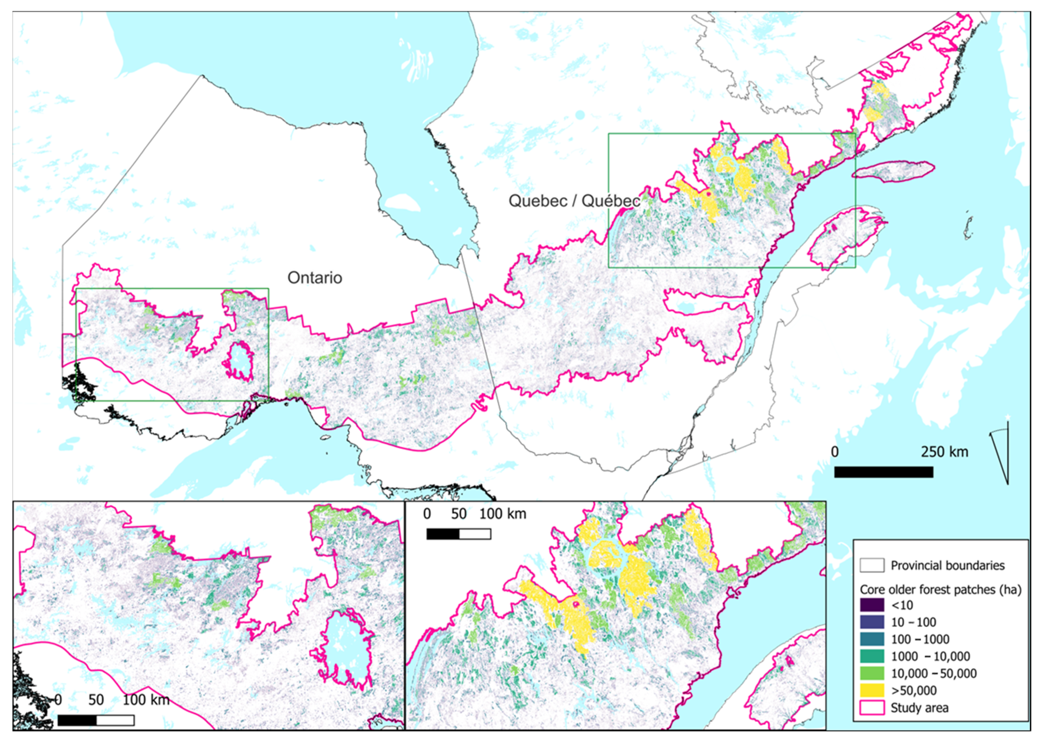
| Class | Older Forests (≥100 Years) (ha) | Critical Caribou Habitat in Local Population Ranges (ha) |
|---|---|---|
| Core | 8,359,381 | 6,103,534 |
| Edge | 3,423,706 | 1,190,911 |
| Perforation | 424,040 | 532,055 |
| Branch | 2,348,692 | 395,647 |
| Bridge | 3,477,735 | 369,369 |
| Islet | 2,538,021 | 182,047 |
| Loop | 680,345 | 249,439 |
| Patch Size (ha) | Patch Count | |
|---|---|---|
| Older Forests (≥100 yrs) | Critical Caribou Habitat in Local Population Ranges | |
| 0–0.25 | 1,085,822 | 176,818 |
| 0.25–0.5 | 360,189 | 63,465 |
| 0.5–1 | 242,863 | 43,315 |
| 1–2 | 156,393 | 33,776 |
| 2–3 | 69,139 | 15,377 |
| 3–4 | 40,443 | 9176 |
| 4–5 | 26,705 | 6188 |
| 5–10 | 62,695 | 14,818 |
| 10–25 | 44,435 | 11,888 |
| 25–50 | 16,892 | 5113 |
| 50–100 | 8548 | 3095 |
| 100–250 | 4701 | 2125 |
| 250–500 | 1452 | 869 |
| 500–1000 | 664 | 505 |
| 1000–10,000 | 542 | 505 |
| 10,000–50,000 | 52 | 55 |
| 50,000–250,000 | 7 | 12 |
| 250,000–500,000 | 1 | 2 |
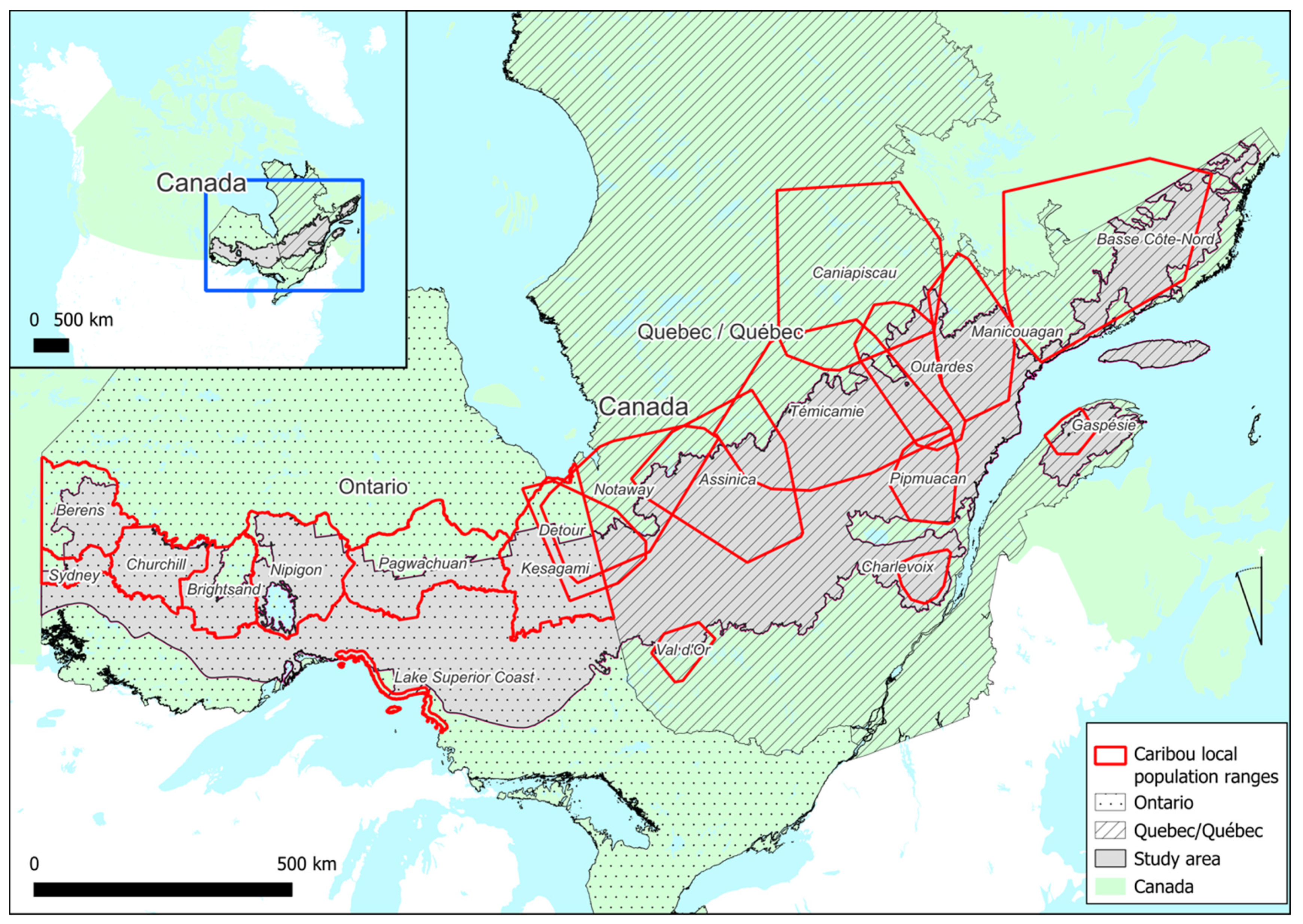
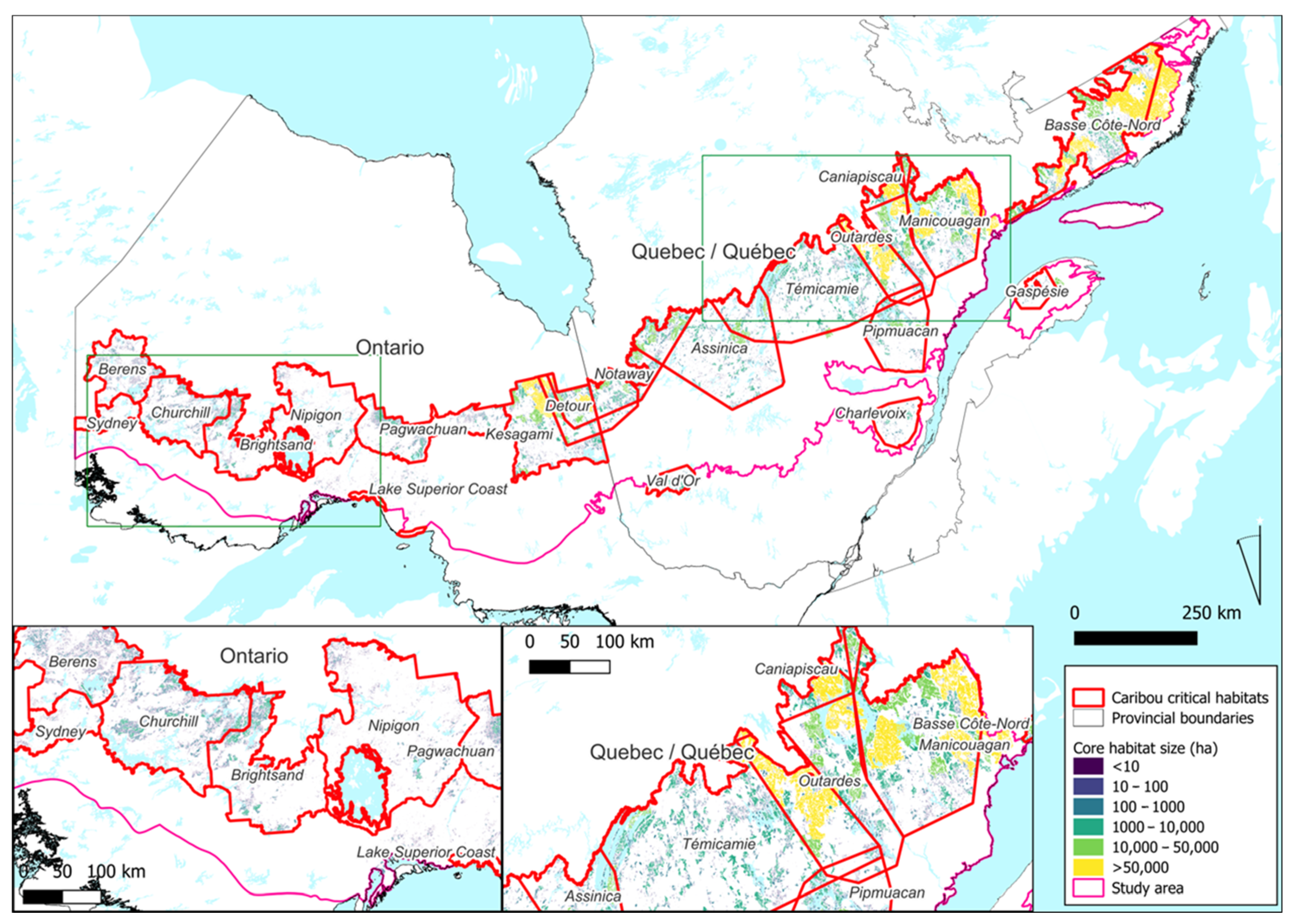
| Population | Local Population Range Area (ha) | Critical Boreal Caribou Habitat Area (ha) | % Local Population Range Disturbed | Level of Risk | Previous Boreal Caribou Assessment (Source: Environment Canada (2011)) |
|---|---|---|---|---|---|
| Assinica | 5,109,938 | 850,283 | 72.6 | High | NA |
| Basse Côte-Nord | 3,490,665 | 1,663,848 | 34.9 | Low | NA |
| Berens | 1,612,106 | 369,895 | 46.4 | High | RNSS/RSS, as likely as not |
| Brightsand | 1,525,297 | 241,067 | 65.6 | High | RNSS/RSS, as likely as not |
| Caniapiscau | 540,674 | 262,596 | 34.9 | Low | NA |
| Charlevoix | 777,738 | 60,548 | 90.3 | Very High | RNSS, very unlikely |
| Churchill | 2,035,815 | 427,948 | 49.0 | High | RSS, likely |
| Coastal | 162,874 | 7531 | 45.3 | High | RSS, likely |
| Detour | 1,977,443 | 676,313 | 50.9 | High | NA |
| Gaspésie | 425,460 | 42,938 | 87.5 | Very High | NA |
| Kesagami | 3,373,204 | 1,042,716 | 53.5 | High | RNSS, very unlikely |
| Manicougan | 2,742,141 | 1,062,412 | 47.2 | High | RSS, likely |
| Manouane | 2,716,465 | 812,296 | 58.1 | High | RNSS/RSS, as likely as not |
| Nipigon | 2,928,933 | 243,926 | 74.4 | High | RSS, likely |
| Notaway | 2,371,806 | 877,779 | 46.3 | High | NA |
| Outardes | 2,775,318 | 983,492 | 50.7 | High | NA |
| Pagwachuan | 2,165,773 | 408060 | 67.8 | High | RSS, likely |
| Pipmuacan | 1,911,249 | 279,546 | 75.2 | Very High | RNSS, unlikely |
| Sydney | 578,902 | 69,528 | 50.0 | High | RNSS, unlikely |
| Témicamie | 6,465,416 | 1,336,048 | 67.8 | High | NA |
| Val d’Or | 385,381 | 54,876 | 75.8 | Very High | RNSS, unlikely |
Disclaimer/Publisher’s Note: The statements, opinions and data contained in all publications are solely those of the individual author(s) and contributor(s) and not of MDPI and/or the editor(s). MDPI and/or the editor(s) disclaim responsibility for any injury to people or property resulting from any ideas, methods, instructions or products referred to in the content. |
© 2023 by the authors. Licensee MDPI, Basel, Switzerland. This article is an open access article distributed under the terms and conditions of the Creative Commons Attribution (CC BY) license (https://creativecommons.org/licenses/by/4.0/).
Share and Cite
Mackey, B.; Campbell, C.; Norman, P.; Hugh, S.; DellaSala, D.A.; Malcolm, J.R.; Desrochers, M.; Drapeau, P. Assessing the Cumulative Impacts of Forest Management on Forest Age Structure Development and Woodland Caribou Habitat in Boreal Landscapes: A Case Study from Two Canadian Provinces. Land 2024, 13, 6. https://doi.org/10.3390/land13010006
Mackey B, Campbell C, Norman P, Hugh S, DellaSala DA, Malcolm JR, Desrochers M, Drapeau P. Assessing the Cumulative Impacts of Forest Management on Forest Age Structure Development and Woodland Caribou Habitat in Boreal Landscapes: A Case Study from Two Canadian Provinces. Land. 2024; 13(1):6. https://doi.org/10.3390/land13010006
Chicago/Turabian StyleMackey, Brendan, Carly Campbell, Patrick Norman, Sonia Hugh, Dominick A. DellaSala, Jay R. Malcolm, Mélanie Desrochers, and Pierre Drapeau. 2024. "Assessing the Cumulative Impacts of Forest Management on Forest Age Structure Development and Woodland Caribou Habitat in Boreal Landscapes: A Case Study from Two Canadian Provinces" Land 13, no. 1: 6. https://doi.org/10.3390/land13010006
APA StyleMackey, B., Campbell, C., Norman, P., Hugh, S., DellaSala, D. A., Malcolm, J. R., Desrochers, M., & Drapeau, P. (2024). Assessing the Cumulative Impacts of Forest Management on Forest Age Structure Development and Woodland Caribou Habitat in Boreal Landscapes: A Case Study from Two Canadian Provinces. Land, 13(1), 6. https://doi.org/10.3390/land13010006