Communication

Long-Term Impact of Ground Deformation on Vegetation in an Underground Mining Area: Its Mechanism and Suggestions for Revegetation

1
Engineering Research Center of Ministry of Education for Mine Ecological Restoration, China University of Mining and Technology, Xuzhou 221116, China
2
School of Public Policy and Management, China University of Mining and Technology, Xuzhou 221008, China
3
Jiangsu Research Center of Land Resources, Nanjing 210017, China
4
Key Laboratory of Land Consolidation, Ministry of Natural Resources, Beijing 100035, China
*
Authors to whom correspondence should be addressed.
Land 2023, 12(6), 1231; https://doi.org/10.3390/land12061231
Submission received: 28 May 2023 / Revised: 12 June 2023 / Accepted: 13 June 2023 / Published: 15 June 2023
(This article belongs to the Section Land Environmental and Policy Impact Assessment)

Abstract

:
Ground deformation is one of the most common geological disasters arising in underground mining areas, and mining-induced environmental impacts have resulted in numerous concerns, especially the impacts on the surface vegetation. The evaluation of mining-induced impacts on vegetation is beneficial to revegetation in mining areas; however, the impacts of ground deformation have seldom been systematically evaluated and explained on long time scales despite the long-term existence of ground deformation in underground mining areas. To address this, in this study a vegetation-soil-climate (VSC) model was developed to evaluate the long-term impacts of ground deformation on vegetation, and to reveal its mechanism. The results revealed that the long-term impacts of ground deformation on vegetation result from the degradation of the vegetation and soil when ground deformation occurs, which thereby limits the growth and succession of plants after the ground deformation has occurred. The intensity of the long-term impacts is determined by the severity of the ground deformation, but the duration, climate factors, the substrate conditions of the vegetation and soil before the deformation, and the natural change coefficient of the vegetation and soil are also relevant. Furthermore, the characteristics of the long-term impacts on vegetation were analyzed, and a framework for implementing revegetation and suggestions for the supervision of revegetation in underground mining areas are presented based on the characteristics. The results of this study provide insights into the impacts of mining-induced ground deformation on vegetation on long time scales, considering the comprehensive interactions between the vegetation and other environmental factors, and provide theoretical support for revegetation in underground mining areas.

1. Introduction

Ground deformation induced by underground mining is a common geological hazard in the mining areas in China, and it has caused severe damage to the environment, especially to the vegetation [1,2]. Generally, most ground deformation, such as land subsidence [3,4], ground fissures [5], and landslides [6], is hard to reverse without land reclamation projects, and thus it exists for a long time in mining areas. As for the effects of ground deformation on vegetation, it is vulnerable to these extensive disturbances, and is likely to be damaged, die, or degenerate in the long term [7]. Therefore, insights into the long-term impacts of ground deformation on vegetation would benefit ecological restoration, especially revegetation, in underground mining areas.
From the perspective of the affecting process, the impact of ground deformation on vegetation can either be short-term or long-term. The word “long-term” does not indicate an absolute and fixed period, but rather reflects the way in which ground deformation continuously affects plant communities over several years, which is relative to a short deformation process. In contrast to these long-term effects, short-term effects mainly represent the change in vegetation caused by ground deformation as it occurs, such as damage to plant organs or the loss of entire communities. In the short term over a period of days and weeks, ground deformation squeezes, stretches, slides, and cracks the soil, leading to damage or even death of the vegetation [8]. In the long term extending over months and years, ground deformation alters hydrological processes, such as infiltration, soil evaporation, and runoff, as well as causing the drop or rise of the ground water table [9,10]. These changes are likely to continuously interfere with plant succession. Although the phrase “long-term” may be difficult to define for a specific time period, distinguishing between the short- and long-term effects of ground deformation on vegetation is not difficult. During ground deformation, surface vegetation is damaged by the squeezing and stretching of the plant roots [11,12], and the plants are likely to grow slowly or eventually die, which is also commonly considered to be a short-term impact on vegetation. In addition, the long-term degradation of plant communities in mining-affected areas has also been noticed [13,14], and thus the long-term impacts of ground deformation on vegetation needs to be discussed. Several studies have found that in areas with ground deformation, there are significant decreases in the vegetation coverage [15] and the carbon stored in vegetation [16], and there have also been changes in the composition of the vegetation observed [17]. In contrast, several studies have concluded that ground deformation has a positive impact on vegetation, including an increased ecological value and a richer composition of plant species compared with areas without deformation [18]. In addition, a few studies have also found that there is no significant difference between the vegetation in deformed areas and that in unmined areas [19]. In general, although the negative effects of underground mining on vegetation in the short-term have been widely recognized [20,21,22], there is still no consensus concerning the long-term impacts of ground deformation on the vegetation.
The mechanism of the long-term impacts of ground deformation on vegetation has also not been systematically explained. In regard to the mechanism underlying the short-term impacts of ground deformation on the vegetation, several researchers have demonstrated that the changes in the soil properties caused by ground deformation are the main factors causing the impacts on vegetation, such as decreases in the soil organic matter, total nitrogen, and moisture [23,24,25]. Furthermore, the hydrology in mining-impacted areas has also changed, such as interruptions in the surface water runoff patterns resulting from changes in the surface topography and soil compaction [26]. However, these studies seldom considered the comprehensive interactions between the soil, vegetation, and other factors [27], and did not explain the positive and non-significant impacts of ground deformation. Although the theory of resilience [28,29], the intermediate disturbance hypothesis [30,31], and wave-like terrain [32] have been used to demonstrate the diverse responses of vegetation in deformed areas, there has been no consensus on the long-term impacts of ground deformation, and no studies have focused on the mechanism of these long-term impacts.
The goal of this study was to reveal the mechanism of the long-term impacts of ground deformation on vegetation. To address this, a vegetation-soil-climate model (VSC model) was developed to assess the long-term impacts of ground deformation on vegetation, and the characteristics of these long-term impacts were subsequently analyzed. Suggestions for revegetation in underground mining areas based on the mechanism of the long-term impacts of ground deformation are presented from the perspective of the implementation and supervision of revegetation. The results of this study provide insights into the impacts of ground deformation on vegetation on long time scales and are beneficial to both update and improve the framework of revegetation in underground mining areas.

2. Materials and Methods

2.1. Theoretical Analysis of the Long-Term Impacts of Ground Deformation on the Vegetation

The changes in vegetation due to the short-term and long-term impacts of ground deformation were analyzed (Figure 1) in order to ascertain the differences between these two types of impacts. The initial vegetation pattern in a mining area before ground deformation is shown in Figure 1a, which is characterized by the spontaneous succession of plant communities. When ground deformation has taken place, some of the vegetation suffered short-term impacts, and it died quickly due to the stretching and squeezing damage induced by the ground deformation, including subsidence and cracks (Figure 1b). When the ground deformation stopped, the topography of the mined-out area was altered extensively due to ground deformation. Under such topographical conditions, the original hydrological processes, including rainfall, infiltration, and evaporation, also changed in the new environment [33], and the plant communities began a new spontaneous succession (Figure 1c). After several years of spontaneous succession, a new vegetation pattern formed under the long-term impacts of the ground deformation (Figure 1d).
The short-term and long-term impacts of ground deformation on the vegetation are different in terms of the processes and results of the impacts. As shown in Figure 2, for the short-term impacts, when the ground deformation was dynamic, it caused direct physical damage to the plants, and thus it typically led to the death or damage of the vegetation. However, once the ground deformation stabilized, significant changes in the terrain had occurred, which altered the hydrological processes, resulting in changes in the site conditions, and finally leading to the degradation of the involved plant communities.

2.2. Vegetation-Soil-Climate Model

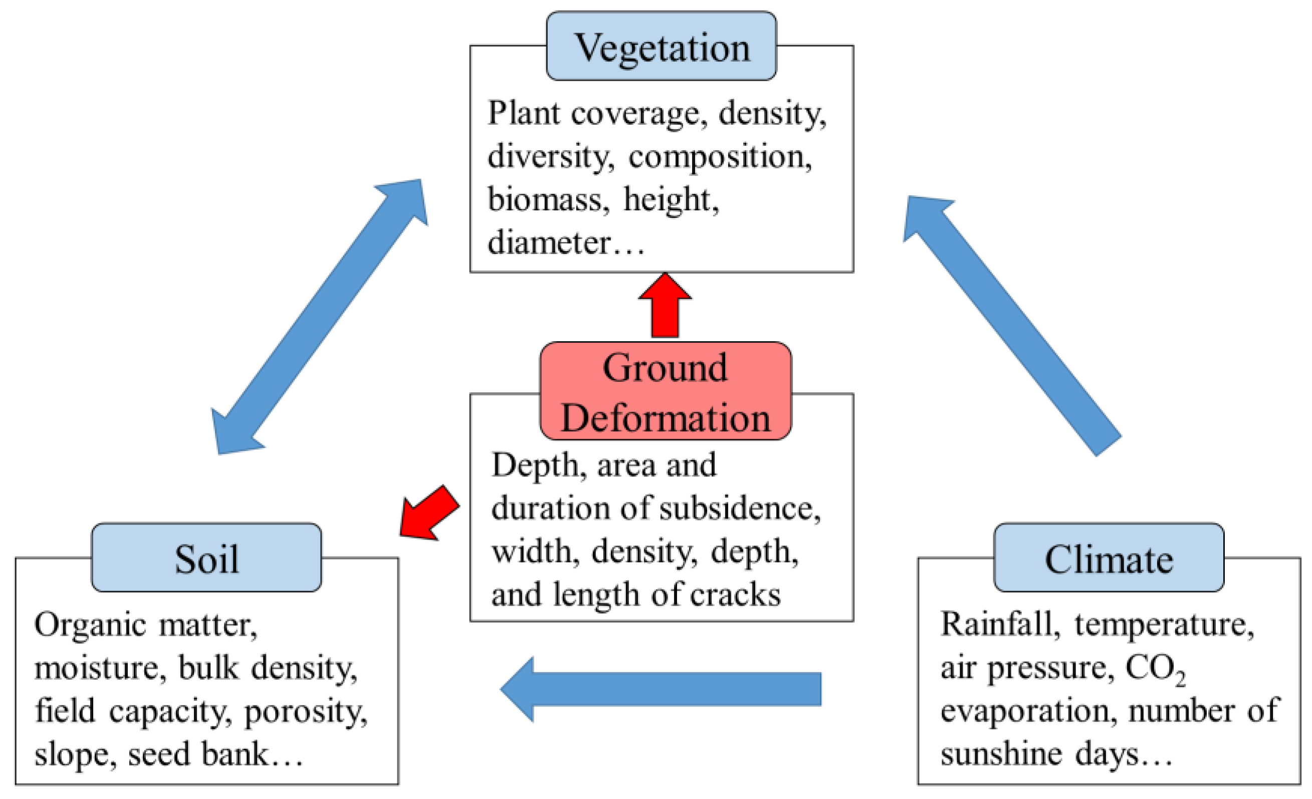
A vegetation-soil-climate model was developed to assess the long-term impacts of ground deformation on vegetation and to determine their mechanisms. Although various factors, including a large number of indicators, are involved in the growth and development of vegetation, the state of any vegetation at any time and in any place is mainly reflected by three types of factors which are as follows: vegetation, soil, and the climate (Figure 3). First, the indicators of vegetation, such as plant coverage, diversity, and traits, not only directly reveal the status of the structure, composition, and function of the vegetation in the current period, but also determine the future developmental potential of the vegetation. Thus, the vegetation itself should be considered as an important factor when determining the status of the vegetation. In addition, as the basis of vegetation, the soil has a close interaction with the vegetation, and it can affect the vegetation through the terrain, altitude, nutrients, and the microbial communities living in the soil [34], and therefore it is also considered to be a key factor for inverting the vegetation status. In addition, indicators such as rainfall, day light hours, temperature, and evaporation, which reflect both the material and energy that the vegetation obtains from the outside world, should be regarded as some of the key factors reflecting the vegetation. Given that most of these indicators can reveal that all of the external effects on the vegetation are mainly related to the climate, they can thereby be summarized as a climate factor.
Therefore, the status of any vegetation at any time and in any place can be revealed with the vegetation, soil, and climate factors, and can be expressed as shown in Equations (1)–(4):
G t = f V t ,   S t ,   C t ,
V t = α 1 v 1 t + α 2 v 2 t + + α n v n t ,
S t = β 1 s 1 t + β 2 s 2 t + + β m s m t ,
C t = γ 1 c 1 t + γ 2 c 2 t + + γ o c o t .
where G(t) is the status of a vegetation at time t, and V(t), S(t), and C(t) are the statuses in terms of the vegetation, soil, and climate factors, respectively. n, m, and o are the number of secondary indicators of the vegetation, soil, and climate factors, respectively, and α, β, and γ are the weights of each secondary indicator of the vegetation, soil, and climate factors, respectively. v, s, and c are the normalized values of the secondary indicators of the vegetation, soil, and climate factors, respectively.
v n t = v n v n m a x v n m i n ,
s m t = s m s m m a x s m m i n ,
c o t = c o c o m a x c o m i n .
As shown in Equations (5)—(7), vn, sm, and co are the secondary indicators of the vegetation, soil, and climate factors, respectively, and the suffixes max and min are the maximum and minimum values of the secondary indicators of the vegetation, soil, and climate factors, respectively, in the value range suitable for vegetation growth.
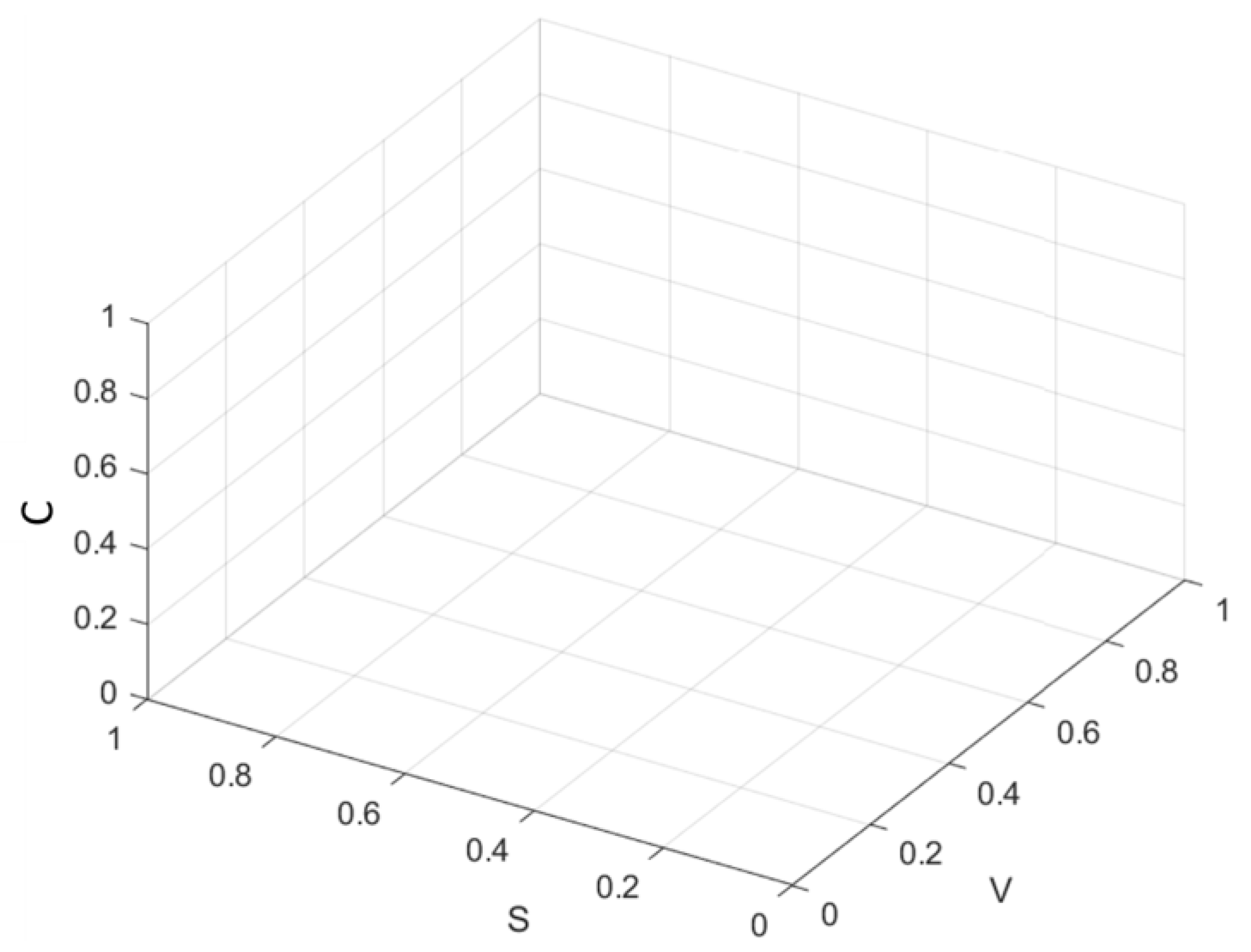
According to Equation (1), the state of the vegetation at any time t can be expressed in the form of G (V, S, and C), and thus a three-dimensional coordinate system composed of the vegetation, soil, and climate can be established as a result (Figure 4). In this system, the coordinate ranges of V, S, and C are all [0, 1]. When the value was equal to 0, the corresponding ecological meaning was deemed as the extinction of the vegetation, loss of soil, or extreme climate, which would make it impossible for the vegetation to survive. When the value was equal to 1, the vegetation, soil, and climate factors were determined as optimal, and that the vegetation was in the best theoretical state.
In the VSC model, the changes in the status of the vegetation are caused by two driving forces: the short-term and long-term impacts, respectively. The short-term impacts refer to the impacts induced by the activities that cause changes in the vegetation in a short period of time, such as floods, fires, deforestation, vegetation reconstruction, land reclamation, and other activities that either destroy or restore vegetation quickly. Short-term impacts consist of two types of indicators, the initial conditions of the vegetation ( V t 0 ) and soil ( S t 0 ) factors, and the disturbance coefficients. Under the same disturbance, the vegetation and soil factors encompassing diverse initial conditions will exhibit different responses. In addition, given that the vegetation and soil factors can exhibit diverse responses to the same impacts, the disturbance coefficients Kv and Ks are used to represent the severity of the short-term impacts on the vegetation and soil factors, respectively. The climate factor will usually not change in the short term due to an external disturbance, and therefore the short-term impacts on the climate were not considered.
The long-term impacts on the vegetation refer to the impacts that lead to slow changes in the vegetation, soil, and climate factors, mainly including slowly-occurring ecological processes, such as community succession, soil maturation, and climate change. Five types of indicators determine the long-term impacts together, which are as follows: the initial conditions of the vegetation ( V t 0 ) and soil ( S t 0 ) factors, the duration of the long-term impacts ( Δ t 0 1 ), the average condition of the climate factor within the duration ( C t 0 + C t 1 2 ), and the natural change coefficients (Mv, Ms, and Mc). Generally, vegetation under better substrate conditions has a stronger growth trend under the same natural conditions [35]. Similarly, the richer the plant community, the more nutrients that the soil could obtain from the vegetation, and the faster the soil maturation rate [36]. Thus, the initial conditions of the vegetation V t 0 and soil S t 0 factors are important in the assessment of the long-term impacts. In addition, since long-term impacts usually occur slowly, the duration of the long-term impacts ( Δ t 0 1 ), and the average condition of the climate factor within the duration ( C t 0 + C t 1 2 ) should also be included. Most of these ecological processes are driven by natural forces, and thus the natural change coefficients Mv, Ms, and Mc can be used to indicate the strength of the effects of the natural forces on the vegetation, soil, and climate factors, respectively. As for the natural change coefficients, they can be considered as two fixed values under similar climate factors, which mainly depend on the climate factors such as light, temperature, and rainfall in the area over a period, and are not affected by the initial conditions of the soil and vegetation or other external activities.
Therefore, the vegetation, soil, and climate factors at t1 are different from those at t0 under both the short-term and long-term impacts, and can be expressed by the Equations (8)–(10):
V t 1 = V t 0 + Δ V t 0 t 1 = V t 0 + Δ V t 0 t 1 K + Δ V t 0 t 1 M   = V t 0 + V t 0 K v + V t 0 S t 0 C t 0 + C t 1 2 M v Δ t 0 1 ,
S t 1 = S t 0 + Δ S t 0 t 1 = S t 0 + Δ S t 0 t 1 K + Δ S t 0 t 1 M   = S t 0 + S t 0 K s + V t 0 S t 0 C t 0 + C t 1 2 M s Δ t 0 1 ,
C t 1 = C t 0 + Δ C t 0 t 1   = C t 0 + C t 0 M c Δ t 0 1 .
where Δ t 0 1 is the duration between t0 and t1; V(t0), S(t0), and C(t0) are the states of the vegetation, soil, and climate factors at t0; Mv, Ms, and Mc represent the natural change coefficients of the vegetation, soil, and climate, indicating the strength of the effects of the natural forces on the vegetation, soil, and climate factors, respectively; and Kv and Ks are the disturbance coefficients, representing the severity of the short-term impacts on the vegetation and soil factors, respectively.

2.3. Study Area and Date Resouces

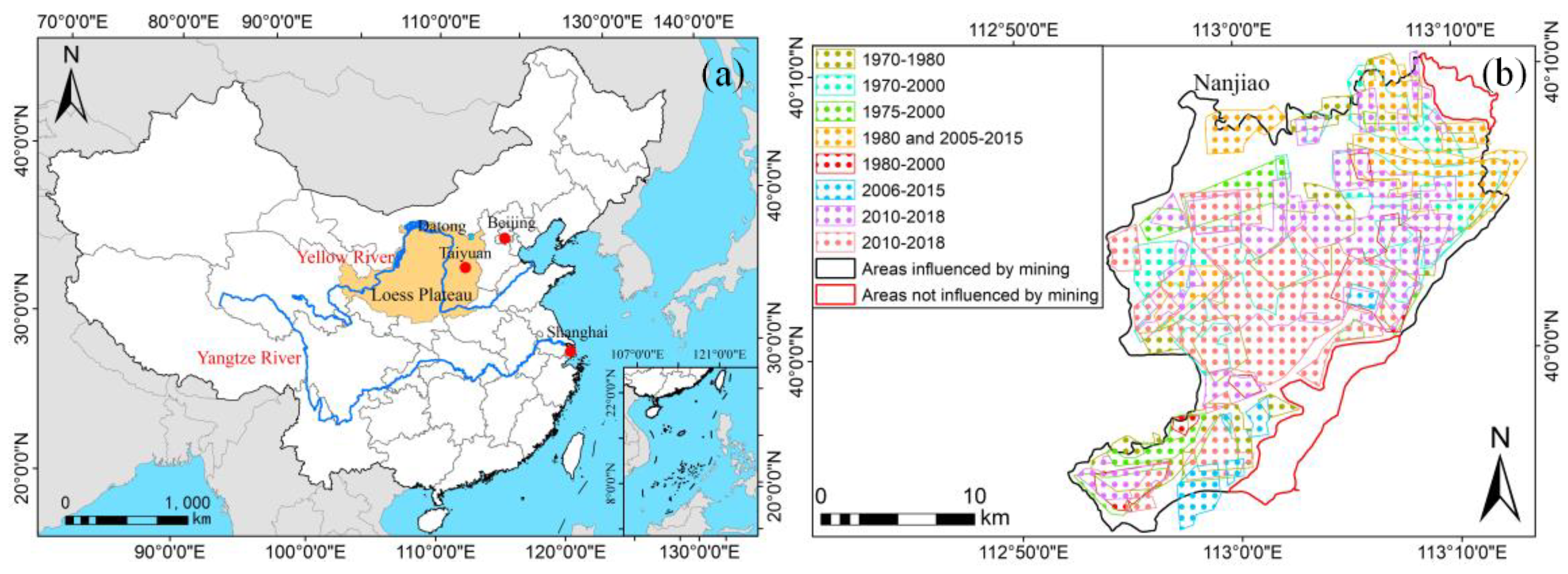
To assess and verify the accuracy performance of the VSC model, the long-term impacts of ground deformation on vegetation in the Yungang mining area, located in Nanjiao District, Datong City, Shanxi Province, China (Figure 5a) were evaluated via the VSC model. The semi-arid continental climate of this area has a mean annual temperature of 6.4 °C, and a mean annual precipitation of 384.6 mm, with the precipitation mainly occurring from June to September. The average annual evaporation rate varies between 1700 mm and 2100 mm, respectively, with a relative humidity of less than 55%. The loess soil is typically composed of approximately 65% sand (0.02–2.0 mm), 29.47% silt (0.002–0.02 mm), and 5.53% clay (<0.002 mm), respectively. The Pingchuan hills dominate the area, while the terrain elevation is generally high in the northwest and low in the southeast, with an average elevation of 1250 m. This area with coal mining subsidence covers five townships (the townships of Pingwang, Kouquan, and Ya’er Cliff, and the towns of Gaoshan and Yungang), with a total area of 459.37 km2. A long history of coal mining in the Nanjiao mining area can be traced back 1500 years. By the end of 2000, 191 coal mining enterprises were active in the southern suburbs. The large-scale mining of coal has led to a large area of subsidence which, as of 2015, involved 331.59 km2. The Nanjiao mining area can be classified into two parts: areas that are influenced and not influenced by mining, which covered about 416.52 km2 and 42.85 km2, respectively (Figure 5b). Data on the depth of the subsidence were acquired from the subsidence prediction report, which was provided by the local mine enterprises and the government. The depth of the subsidence ranged between 0 and 5.27 m, respectively. The areas with the depths of subsidence from 0 to 0.5 m, 0.5 to 1 m, 1 to 2 m, and over 2 m were 5.16 km2, 1.19 km2, 1.25 km2, and 0.44 km2, respectively. A total of 45 ground cracks were found, which were mainly distributed at the edges of the subsidence area, with depths between 0.5 and 4 m, respectively.
The indicators of the vegetation, soil, and climate in the study area were collected and subsequently used to calculate the long-term impacts of ground deformation. In terms of the vegetation, trees were determined using supervised classification and Landsat imagery from our previous study [37,38], and the NDVI of trees was selected as the basic parameter that reflects the growth status of the vegetation, while three indicators based on NDVI were used to evaluate the long-term effects of underground mining, including the average values of annual average NDVI (ANDVIave), annual-maximum NDVI (ANDVImax) and annual-minimum NDVI (ANDVImin), respectively. To determine the NDVI of the trees, 30 sample points were randomly selected from the trees in areas influenced and not influenced by mining, and the NDVI of selected points in 1987 and 2017 were acquired from the Google Earth Engine. As for the soil, soil moisture content (SMC), bulk density (BD), field capacity (FC), soil porosity (SP), and soil organic matter (SOM) content were determined via field survey and laboratory analysis, as well as the data acquired from previous research [39]. Rainfall was selected as the factor of the climate, and rainfall data from the study area collected from 1955 to 2019 [40] were used as a reference to determine the parameters of the rainfall.

3. Results

3.1. Long-Term Impacts of the Ground Deformation on Vegetation via the VSC Model

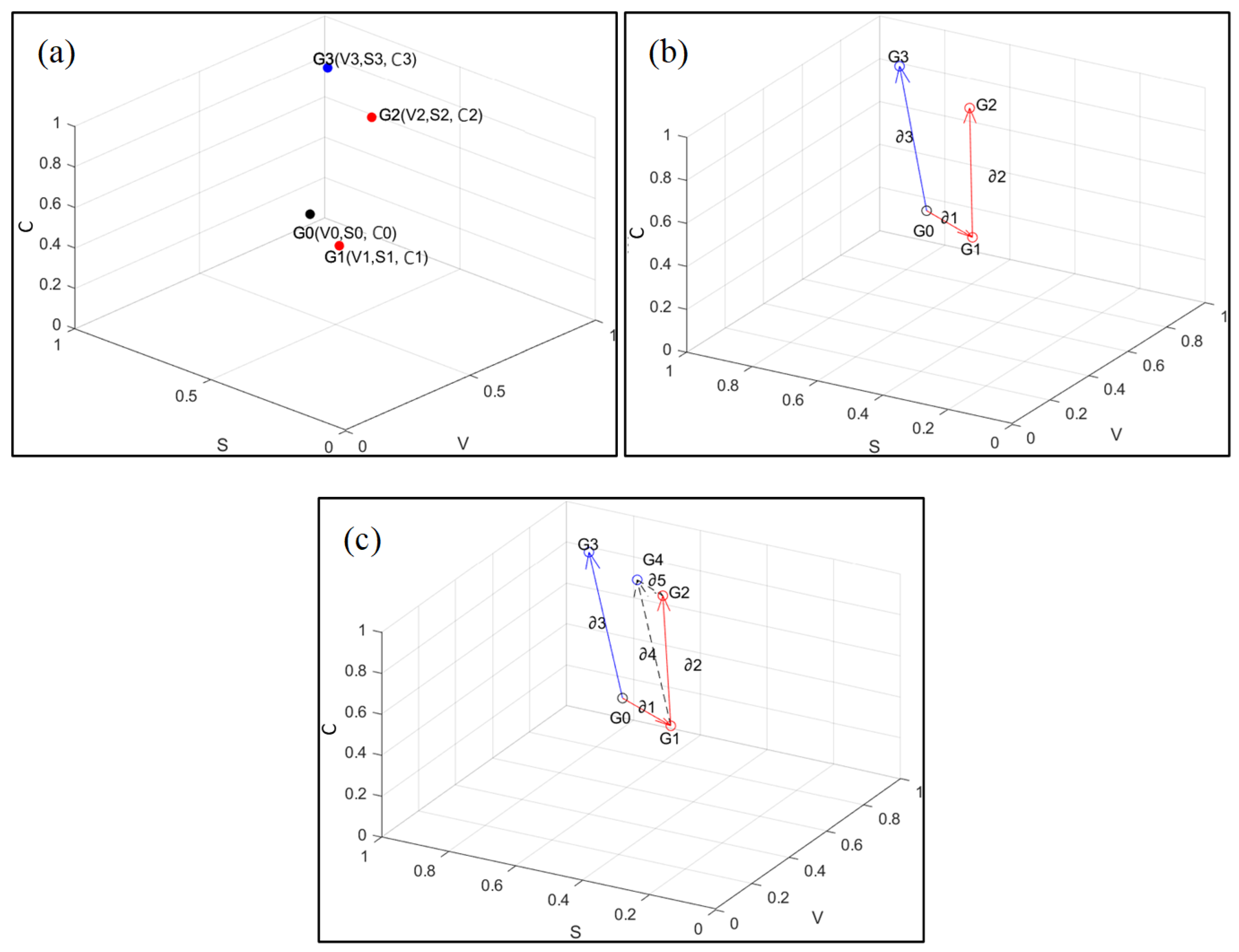
Changes in the vegetation status under the long-term impacts of ground deformation within the VSC system are illustrated in Figure 6. Point G0 (V0, S0, W0) was randomly selected to represent the initial status of the vegetation prior to the ground deformation (Figure 6a). When the deformation occurred between t0 and t1, the vegetation was impacted by the ground deformation during ∆t0–1, and its status subsequently shifted from G0 to G1 (V1, S1, W1). After this, the vegetation experienced a spontaneous succession from t1 to t2 under the long-term impacts of the ground deformation, and then its state shifted from G1 to G2 (V2, S2, W2), where t2 > t1. In addition, an ideal scenario where no mining occurred was also constructed to act as a contrast scenario, and the vegetation subsequently went through a spontaneous succession of ∆t0–1 and ∆t1–2 from G0 to G3 (V3, S3, W3) at t3 (Figure 6b). Since ∆t0–1 is much smaller than ∆t1–2, the changes caused by the natural force during ∆t0–1 can be ignored, and thus the natural driving forces from G1 to G2, and from G1 to G3 can be treated the same. Therefore, ∂3 can be translated and started with G1 to obtain a new vector ∂4, whose end point is G4 (V4, S4, W4). In addition, G4 was set as the starting point and G2 was set as the end point to obtain vector ∂5, respectively. Vector ∂4 reflects the driving force caused by the natural driving of the vegetation at point G1, while G4 represents the theoretical state that the plant could achieve under this driving force (Figure 6c).
Since the climate factor is only related to the duration, in order to understand the changes occurring in the state of the vegetation, changes in the vegetation and soil elements were mainly considered. Thus, the vector of the vegetation during the developmental process from G0 to G1, G2, and G3 was projected onto the V-S two-dimensional coordinate system (Figure 7). It was found that the difference between the status at G4 and G2 was caused by the long-term impacts of the ground deformation, which is represented by ∂5.
According to the relationships between each vector, ∂5 can be calculated using the following equations:
2 = 4 + 5 ,
4 = 3 .
Thus,
5 = 2 3 ,
2 = G 2 G 1 = V 2 , S 2 , C 2 V 1 , S 1 , C 1     = V 2 V 1 , S 2 S 1 , C 2 C 1 ,
3 = G 3 G 0 = V 3 , S 3 , C 3 V 0 , S 0 , C 0   = V 3 V 0 , S 3 S 0 , C 3 C 0 .
Thus,
5 = V 2 V 1 V 3 + V 0 ,   S 2 S 1 S 3 + S 0 ,   C 2 C 1 C 3 + C 0 .
According to Equations (10) and (16), it is easy to conclude that W0 = W1 and W2 = W3, and thus, ∂5 can be expressed as follows:
5 = V 2 V 1 V 3 + V 0 ,   S 2 S 1 S 3 + S 0 ,   0 .
In order to facilitate the exploration of the specific value space of ∂5, the vegetation factors were selected to act as an example to perform the factorization.
V 2 V 1 V 3 + V 0 = V 1 + Δ V 12 V 1 V 0 + Δ V 03 + V 0 = Δ V 12 Δ V 03 = V 0 + V 0 K v + V 0 S 0 C 0 + C 1 2 M v Δ t 0 1 K v       + V 0 + V 0 K v + V 0 S 0 C 0 + C 1 2 M v Δ t 0 1 ( S 0 + S 0 K s       + V 0 S 0 C 0 + C 1 2 M s Δ t 0 1 ) C 1 + C 2 2 M v Δ t 1 2       ( V 0 K v + V 0 S 0 C 0 + C 3 2 M S Δ t 0 3 ) .
where Kv′, Kv″, and ∆t0–1 are equal to 0 as
V 1 = V 0 + V 0 K v + V 0 S 0 C 0 + C 1 2 M v Δ t 0 1 ,
S 1 = S 0 + S 0 K s + V 0 S 0 C 0 + C 1 2 M s Δ t 0 1 ,
V 2 V 1 V 3 + V 0 = V 0 + V 0 K v S 0 + S 0 K s C 1 + C 2 2 M v Δ t 1 2 V 0 S 0 C 0 + C 3 2 M v Δ t 0 3 , = V 0 S 0 + V 0 S 0 K v + K s + V 0 S 0 K v K s C 1 + C 2 2 M v Δ t 1 2 V 0 S 0 C 1 + C 2 2 M v Δ t 1 2 , = V 0 S 0 C 1 + C 2 2 M v Δ t 1 2 K v + K s + K v K s .
the same can be obtained as follows:
S 2 S 1 S 3 + S 0 = V 0 S 0 C 1 + C 2 2 M s Δ t 1 2 K v + K s + K v K s ,
and thus,
5 = V 0 S 0 C 1 + C 2 2 M v Δ t 1 2 K v + K s + K v K s , V 0 S 0 C 1 + C 2 2 M s Δ t 1 2 K v + K s + K v K s , 0 .
Among them, V0, S0, C1, C2, Mv, Ms, and Δ t 1 2 for a certain vegetation change in a certain period of time can be regarded as constants greater than 0, and thus V 0 S 0 C 1 + C 2 2 M v Δ t 1 2 and V 0 S 0 C 1 + C 2 2 M s Δ t 1 2 actually indicate that the vegetation and soil factors are driven by nature from t1 to t2, and that changes have indeed occurred. Therefore, the long-term impacts of the ground deformation on the vegetation was determined by the value of the function μ = Kv + Ks + KvKs, which represents the combined effects of the ground deformation on the vegetation and soil, and it can also be intuitively understood as the intensity of the ground deformation.
Based on Equation (23), it was concluded that the long-term impacts of the ground deformation on the vegetation resulted from the degradation of the vegetation and soil when the ground deformation occurred, which thereby resulted in the limited growth and succession of the plants. The severity of the ground deformation determined the intensity of the long-term impacts, while the duration, climate factors, and substrate conditions of the vegetation and soil before the deformation, along with the natural change coefficients of the vegetation and soil themselves were also found to be able to influence the degree of these long-term impacts. Therefore, the long-term impacts of the ground deformation exhibited different characteristics to the short-term impacts, which have been more frequently studied, and these should be considered when planning the revegetation underground mining areas.

3.2. Accuracy of the VSC Model

The selected indicators of the vegetation, soil, and climate in the subsidence and reference areas at 1987 and 2017 are shown and compared (Table 1). According to Equation (23) of the VSC model, the indicators of the subsidence and reference areas were used to calculate the long-term impacts of the ground deformation on the vegetation after normalization with Equations (4)–(6). The results showed that the long-term impacts of ground deformation led to a decrease from 5.93% to 10.7% in the status of the trees in the study area according to VSC model. To assess the accuracy of the VSC model, an assessment of the long-term impacts of ground deformation on vegetation from our previous research acted as a reference [41], which applied time-series NDVI data and a vegetation growth contract model (VGCM) to estimate the long-term impacts of ground deformation, showing an average decrease of 6.79% in the status of the trees. The R2 between the results from VSC and VGCM was calculated as 0.9067 through linear regression, showing a high performance in the accuracy of the VSC model (Figure 8).

4. Discussion

4.1. Characteristics of the Long-Term Impacts of Ground Deformation on Vegetation

According to the mechanism of the long-term impacts of ground deformation on vegetation acquired from the VSC model, the long-term impacts encompass spatial heterogeneity, temporal persistence, and passivity.
(1) Spatial heterogeneity. According to Equation (23), the long-term impacts of ground deformation, 5 , is closely related to the disturbance coefficients of the ground deformation, which have a strong spatial heterogeneity due to the characteristics of the ground deformation. Thus, the long-term impacts will be significantly different within the mining area.
(2) Temporal persistence. The long-term impacts of ground deformation on vegetation are a continuous process, and the magnitude of the impacts is related to the duration. Since ground deformation does not typically disappear spontaneously over time, its impacts on the vegetation will persist, and will continue to accumulate as time progresses. In addition, the growth, development, and succession of the vegetation also occur slowly under the phenology, meaning it is difficult for the difference in the state of the vegetation at two points in time to reflect the long-term impacts of the ground deformation. Therefore, the impacts of ground deformation should be regarded as the overall impact within a specified time period, and they cannot be reflected by the change in the vegetation status at a certain time.
(3) Passivity. The long-term impacts of ground deformation on vegetation are not a type of impact that is actively produced, but they indirectly and passively alter the natural forces driving the vegetation. According to the characteristics of ground deformation, the ground deformation will remain stable after the mining subsidence ends. Thus, the driving force of the dynamic change in the vegetation are only the natural forces, which are represented by the rainfall, sunshine, and temperature. Therefore, as a static mining disturbance, ground deformation does not directly affect the vegetation, but it indirectly changes the ecological processes that are closely related to the vegetation, which results in various changes to the vegetation.
Besides the results from the theoretical model developed in this model, similar characteristics of the long-term impacts of ground deformation on the vegetation were noticed in real scenarios. Our previous research applied time-series remote sensing images to detect and evaluate the long-term effects of ground deformation on vegetation, which found that underground mining had a negative effect on the herb, tree, and shrub communities, showing a decrease of −15.10%, −6.79%, and −4.03% in the status of the vegetation, respectively [41]. Furthermore, a plant community succession model based on cellular automata was developed to detect the long-term impacts of ground deformation on plant succession, which found that mining-induced ground deformation had long-term effects on plant succession by limiting the tree communities and promoting the shrub communities, as well as leading to the formation of a heterogenous vegetation pattern [38]. Additionally, our research on the impacts of ground deformation on land use change [37] and soil properties [39] can also support the theory in the long-term impacts of mining-induced ground deformation. In addition, the long-term effects of ground deformation on vegetation were also analyzed by other researchers [42,43]. In semi-arid areas of China, the plant density, coverage, and aboveground biomass in the areas with mining subsidence were found to have decreased by 0–21.5% when compared with an undisturbed area [19]. Four years after ground deformation, the dominant plant species was found to have been transformed from herb communities to shrub communities when compared with an undisturbed area, and the number of perennial herbs was also found to have increased significantly [44]. However, the vegetation canopy density, species richness, and plant numbers in the areas with subsidence were also found to be equal to or even exceed those in an undisturbed area after spontaneous succession [45]. The vegetation coverage, plant diversity, and aboveground biomass, as well as the compositions of the plant communities in the disturbed area can be led to the recovery to the level of the undisturbed areas after 15 years of spontaneous succession [46]. The long-term effects of underground mining on vegetation have also been documented in countries other than China. For example, in Australia, underground mining caused persistent negative effects on wetland hydrology, which forced groundwater-dependent vegetation to be replaced by rainfall-dependent species, resulting in the homogenization of the plant communities [47]. In Poland, the succession and growth of secondary vegetation in post-mining areas were found to be limited by the terrain caused by underground mining, while the depth of, and the distance from subsidence were determined to be important factors influencing the vegetation [48]. In Ghana, underground mining led to the drying of the surface rivers and the extensive degradation of the surrounding vegetation [49]. Several studies have also investigated the alteration of the plant communities following underground mining in terms of the indicators that were acquired using remote sensing images. For instance, the changes in the vegetation coverage in Shanxi Province, China from 1987 to 2020 were detected using Landsat 5, 7, and 8 images [50]. Li et al. (2021) found that coal mining had a relatively small contribution to the changes in the vegetation coverage [51]. The net primary productivity and vegetation coverage were calculated in the Shendong mining area, which is located on the border between the Shaanxi Province and the Inner Mongolia Autonomous Region of China, and similar increasing trends were identified for these two indictors in both the mining-disturbed and undisturbed areas [18].These studies revealed that the impacts of mining-induced ground deformation on vegetation could be a comprehensive and lasting process, as well as be related to multiple factors, which also correspond to the spatial heterogeneity, temporal persistence, and passivity of the long-term impacts of ground deformation.

4.2. Suggestions for Implementing Revegetation in the Underground Mining Areas

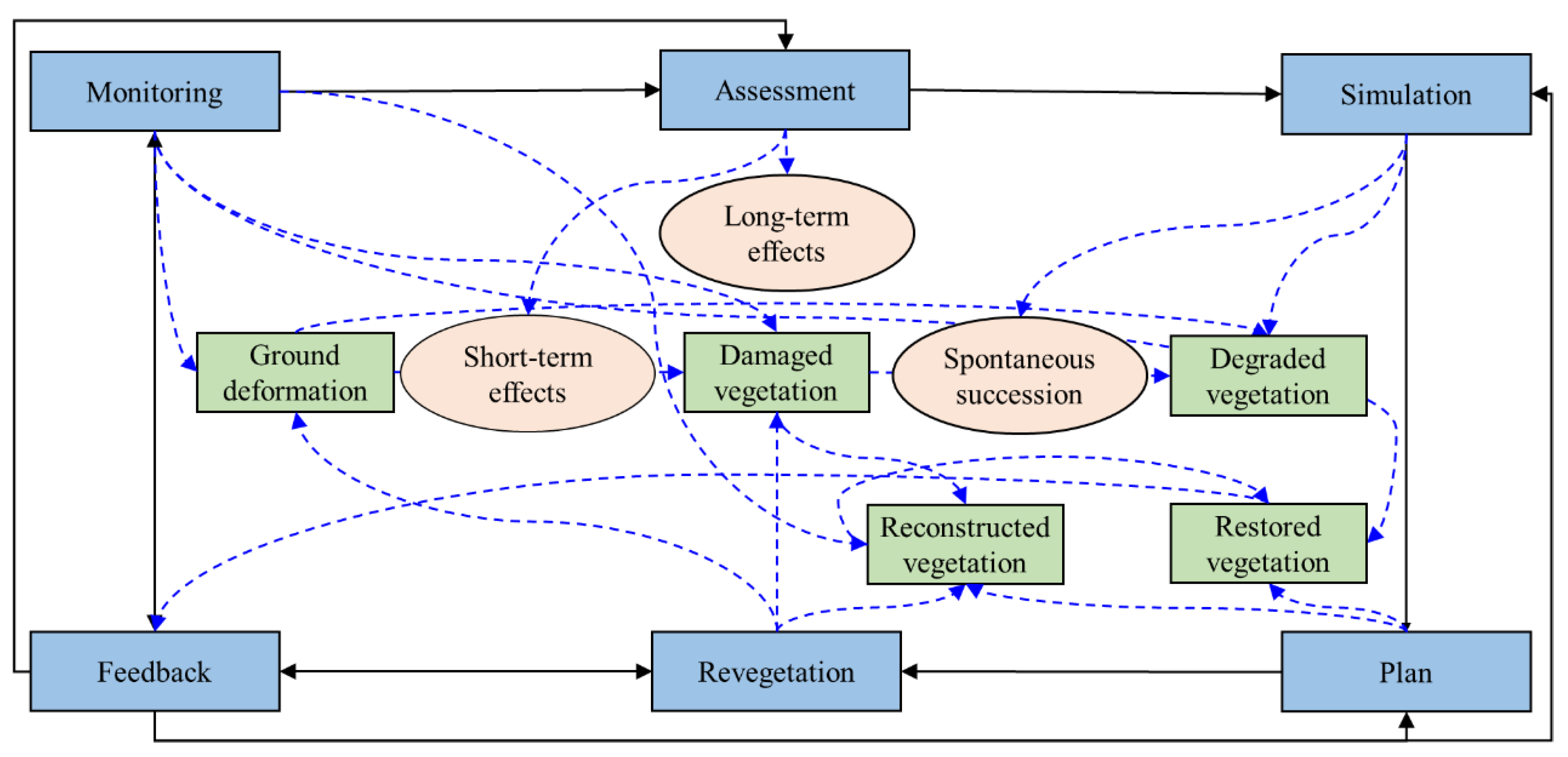
Based on the long-term impacts of ground deformation on vegetation, a framework for implementing revegetation has been proposed (Figure 9). Six steps, including monitoring, assessment, simulation, planning, revegetation, and feedback, are needed to progress from damaged vegetation to reconstructed vegetation.
(1) Monitoring. The information about the ground deformation and the current status of and changes in the damaged vegetation obtained through monitoring are used as the basic data for the follow-up assessment. The vegetation reconstruction and restoration of the vegetation also need to be monitored, and the recovery of the vegetation will be processed in the feedback link.
(2) Assessment. The evaluation link reflects the impact of the ground deformation on the vegetation, focusing on both the short-term and long-term impacts of the ground deformation on the vegetation. Based on the basic data obtained during the monitoring process, the damage assessment can be used to accurately quantify the damage to the vegetation. Among them, the short-term impact evaluation is mainly conducted for the mining area in which ground deformation has just occurred, while the long-term impact evaluation is mainly performed for the historical mining area. The evaluation results provide the basis for the subsequent restoration planning.
(3) Simulation. The simulation step simulates the degraded vegetation under the long-term impacts of the ground deformation and the spontaneous succession from reconstructed vegetation to restored vegetation. Through simulation, the future degradation of the damaged vegetation can be predicted, and the vegetation that is likely to degrade can be identified, which provides a reference for determining the scope of the revegetation for planning purposes. In addition, the spontaneous succession of the reconstructed vegetation can also be simulated, and thus the performance of the revegetation can be predicted, which also helps in the selection of the best method of ecological restoration.
(4) Planning. The planning step determines the desired vegetation after restoration, and the treatment measures that need to be taken to achieve this goal. According to the previous monitoring, evaluation, and simulation steps, the damage to the vegetation in the mining area and the possible future degradation problems are understood. Therefore, the planning step integrates the results of each step to formulate a specific plan for revegetation, and the goal of the planning stage is to ensure that the reconstructed vegetation reaches the expected state of restored vegetation after natural succession.
(5) Reconstruction. The goal of the reconstruction step is to implement the plan created in the planning step. The reconstruction of the ground deformation and damaged vegetation is conducted in accordance with the plan through specific engineering measures, such as land reclamation, vegetation cultivation, and hydrological improvements to ultimately obtain reconstructed vegetation. In addition, according to the results in the feedback step, it may be necessary to carry out continuous management to increase the survival rate of the reconstructed vegetation during the initial period of restoration.
(6) Feedback. The feedback step connects other steps in the implementation framework and improves the effects of each step. The monitoring step is improved based on the results of the assessment; the planning step is improved based on the simulation; the reconstruction step is improved based on the monitoring; the assessment indicators are improved based on the simulation; the simulation is updated based on the planning; and the planning is improved based on the effects of the reconstruction.
In summary, the assessment and simulation of the long-term impacts on the vegetation is the key feature of the above framework for revegetation and is also the main characteristic that differs from the previous framework. Through assessment and simulation, it is possible to ascertain the external disturbances that the vegetation has suffered or may suffer in the future. Feedback can help the reconstructed vegetation overcome obstacles and prevent disturbances over time, thereby enhancing the resilience of the vegetation and the entire ecosystem. Therefore, the reconstructed vegetation is more likely to maintain a better growth state and develop with minimal management and protection, and the ecosystem where the reconstructed vegetation is located can also maintain a better spontaneity quality.

4.3. Suggestions for the Supervision of Revegetation in the Underground Mining Areas

Based on the characteristics of the long-term impacts, three suggestions for the supervision of revegetation in the underground mining areas are presented.
(1) Overall assessment of the revegetation. In most previous revegetation projects, indicators of a single ecological factor were generally used as the standard or acceptance criteria of the projects. This is likely to result in the reconstructed vegetation degrading again due to the limitations of the other ecological factors. In terms of the comprehensive relationships between the various ecological factors under the long-term effects of ground deformation, in addition to the basic indicators, such as the coverage, composition, and diversity of the plant communities, it is also necessary to evaluate the ecological elements closely related to the vegetation, such as the soil fertility, moisture, and slope, as well as the changes in the indicators of various eco-hydrological processes related to the vegetation growth, such as the runoff rate, infiltration rate, and transpiration rate, in order to ensure that the ecosystem in which the vegetation is reconstructed is in a healthy state and developing.
(2) Long-term monitoring of revegetation. The natural law of slow development and changes in the vegetation and other ecological elements makes long-term monitoring necessary. Ecological restoration projects generally have management periods of 1–3 years after completion [52,53]; however, due to the previously discussed long-term impacts of ground deformation on the vegetation, it was found that the changes in the vegetation under the long-term impacts may take 10 or even 20 years to be reflected [54,55], which is mainly determined by the time required for the succession of the plant communities [56,57,58]. The conflict between the laws of nature and the requirements of reality has resulted in many projects paying too much attention to the short-term effects of the repairs. This results in the phenomenon of treating the symptoms but not the root cause. Therefore, the long-term monitoring of revegetation is an important guarantee of the restoration effect.
(3) Real-time management of revegetation. The randomness and contingency of the ecological processes results in the inevitable need for real-time governance. The changes in the ecological elements and ecological processes not only develop stably with phenology but are also dependent on random events, such as a dry climate or extreme rainstorms. These random events may affect the vegetation, and they have noticeable impacts on the vegetation. Generally, natural vegetation has a strong resilience to extreme climate conditions [59,60]. However, reconstructed vegetation, especially in the initial stage of revegetation, may have difficulty withstanding severe climate conditions, thus leading to degradation and even death [61,62,63]. Therefore, the real-time governance of revegetation can help reconstructed vegetation overcome external disturbances, avoid the reverse succession of vegetation, and increase the efficiency of revegetation.

5. Conclusions

In this study, the mechanism of the long-term impacts of ground deformation on vegetation was determined by assessing the impacts using a vegetation-soil-climate model. The VSC model put forward in this paper quantitatively revealed the changes of vegetation under the long-term impacts of ground deformation, which can systematically explain the various responses of vegetation after underground mining. The characteristics of these long-term impacts were analyzed and subsequently used as the basis for the suggestions presented for the implementation and supervision of the revegetation projects. The long-term impacts of ground deformation on vegetation result from the degradation of vegetation and soil when ground deformation occurs, which limit the growth and succession of the plants after ground deformation occurs. The intensity of the long-term impacts is determined by the severity of the ground deformation, but the duration, climate factors, substrate conditions of the vegetation and soil before the deformation, and the natural change coefficient of the vegetation and soil are also relevant. The long-term impacts of ground deformation on vegetation exhibit spatial heterogeneity, temporal persistence, and passivity, and thus the implementation and supervision of revegetation can be improved based on these characteristics. This study has developed a theoretical model for quantitatively assessing the long-term impacts on vegetation considering comprehensive interactions and provides new insights into the impacts of underground mining on vegetation, as well as a systematic illustration of the long-term impacts of mining-induced ground deformation, which can improve revegetation and environmental assessments in the underground mining areas.

Author Contributions

Conceptualization, J.M. and H.H.; writing—original draft preparation, J.M.; writing—review and editing, H.H. and Y.H.; supervision, Z.J. and X.Y.; funding acquisition, H.H. All authors have read and agreed to the published version of the manuscript.

Funding

This research was funded by the “Double First-class” construction projects to improve independent innovation capabilities of China University of Mining and Technology, grand number 2022ZZCX04.

Data Availability Statement

No new data were created or analyzed in this study. Data sharing is not applicable to this article.

Conflicts of Interest

The authors declare no conflict of interest.

References

  1. Zhengfu, B.I.A.N.; Inyang, H.I.; Daniels, J.L.; Frank, O.T.T.O.; Struthers, S. Environmental issues from coal mining and their solutions. Min. Sci. Technol. 2010, 20, 215–223. [Google Scholar]
  2. Zhao, H.; Ma, F.; Zhang, Y.; Guo, J. Monitoring and mechanisms of ground deformation and ground fissures induced by cut-and-fill mining in the Jinchuan Mine 2, China. Environ. Earth Sci. 2013, 68, 1903–1911. [Google Scholar] [CrossRef]
  3. Yang, X.L.; Wen, G.C.; Dai, L.C.; Sun, H.T.; Li, X.L. Ground Subsidence and Surface Cracks Evolution from Shallow-Buried Close-Distance Multi-seam Mining: A Case Study in Bulianta Coal Mine. Rock Mech. Rock Eng. 2019, 52, 2835–2852. [Google Scholar] [CrossRef]
  4. Khanal, M.; Hodgkinson, J.H. Subsidence prediction versus observation in Australia: A short comment. Environ. Impact Assess. Rev. 2021, 86, 106479. [Google Scholar] [CrossRef]
  5. Liu, H.; Deng, K.; Lei, S.; Bian, Z. Mechanism of formation of sliding ground fissure in loess hilly areas caused by underground mining. Int. J. Coal Sci. Technol. 2015, 25, 553–558. [Google Scholar] [CrossRef]
  6. Mi, J.; Liu, R.; Zhang, S.; Hou, H.; Yang, Y.; Chen, F.; Zhang, L. Vegetation patterns on a landslide after five years of natural restoration in the Loess Plateau mining area in China. Ecol. Eng. 2019, 136, 46–54. [Google Scholar] [CrossRef]
  7. Lei, S.; Ren, L.; Bian, Z. Time–space characterization of vegetation in a semiarid mining area using empirical orthogonal function decomposition of MODIS NDVI time series. Environ. Earth Sci. 2016, 75, 516. [Google Scholar] [CrossRef]
  8. Wang, B.; Liu, J.; Wang, C.; Zhang, X. Effects of drawing damage on root growth and soil reinforcement of Hippophae rhamnoides in a coal mining subsidence area. Int. J. Phytoremediation 2022, 24, 409–419. [Google Scholar] [CrossRef] [PubMed]
  9. Wang, Y.; Bian, Z.; Lei, S.; Zhang, Y. Investigating spatial and temporal variations of soil moisture content in an arid mining area using an improved thermal inertia model. J. Arid Land 2017, 9, 712–726. [Google Scholar] [CrossRef]
  10. Chen, G.; Guo, J.; Song, Z.; Feng, H.; Chen, S.; Li, M. Soil water transport and plant water use patterns in subsidence fracture zone due to coal mining using isotopic labeling. Environ. Earth Sci. 2022, 81, 310. [Google Scholar] [CrossRef]
  11. Bi, Y.L.; Zhang, J.; Song, Z.H.; Wang, Z.G.; Qiu, L.; Hu, J.J.; Gong, Y.L. Arbuscular mycorrhizal fungi alleviate root damage stress induced by simulated coal mining subsidence ground fissures. Sci. Total Environ. 2019, 652, 398–405. [Google Scholar] [CrossRef] [PubMed]
  12. Fan, G.; Zhang, S.; Chen, M.; Zhang, D.; Ren, S. Impacts of Underground Coal Mining on the Roots of Xeromorphic Plant: A Case Study. Environ. Eng. Sci. 2020, 38, 500–512. [Google Scholar] [CrossRef]
  13. Pandey, B.; Agrawal, M.; Singh, S. Coal mining activities change plant community structure due to air pollution and soil degradation. Ecotoxicology 2014, 23, 1474–1483. [Google Scholar] [CrossRef] [PubMed]
  14. Rocha-Nicoleite, E.; Overbeck, G.E.; Müller, S.C. Degradation by coal mining should be priority in restoration planning. Perspect. Ecol. Conserv. 2017, 15, 202–205. [Google Scholar] [CrossRef]
  15. Fang, A.; Dong, J.; Cao, Z.; Zhang, F.; Li, Y. Tempo-Spatial Variation of Vegetation Coverage and Influencing Factors of Large-Scale Mining Areas in Eastern Inner Mongolia, China. Int. J. Environ. Res. Public Health 2020, 17, 47. [Google Scholar] [CrossRef] [Green Version]
  16. Huang, Y.; Tian, F.; Wang, Y.J.; Wang, M.; Hu, Z.L. Effect of coal mining on vegetation disturbance and associated carbon loss. Environ. Earth Sci. 2014, 73, 2329–2342. [Google Scholar] [CrossRef]
  17. Liu, Y.; Lei, S.; Chen, X.; Chen, M.; Zhang, X.; Long, L. Study of plant configuration pattern in guided vegetation restoration: A case study of semiarid underground mining areas in Western China. Ecol. Eng. 2021, 170, 106334. [Google Scholar] [CrossRef]
  18. Xiao, W.; Zhang, W.K.; Ye, Y.M.; Lv, X.J.; Yang, W.F. Is underground coal mining causing land degradation and significantly damaging ecosystems in semi-arid areas? A study from an Ecological Capital perspective. Land Degrad. Dev. 2018, 31, 1969–1989. [Google Scholar] [CrossRef]
  19. Yang, Y.; Erskine, P.D.; Zhang, S.; Wang, Y.; Bian, Z.; Lei, S. Effects of underground mining on vegetation and environmental patterns in a semi-arid watershed with implications for resilience management. Environ. Earth Sci. 2018, 77, 605. [Google Scholar] [CrossRef]
  20. Sun, X.; Yuan, L.; Liu, M.; Liang, S.; Li, D.; Liu, L. Quantitative estimation for the impact of mining activities on vegetation phenology and identifying its controlling factors from Sentinel-2 time series. Int. J. Appl. Earth Obs. Geoinf. 2022, 111, 102814. [Google Scholar] [CrossRef]
  21. Liu, S.; Li, W.; Qiao, W.; Wang, Q.; Hu, Y.; Wang, Z. Effect of natural conditions and mining activities on vegetation variations in arid and semiarid mining regions. Ecol. Indic. 2019, 103, 331–345. [Google Scholar] [CrossRef]
  22. Kayet, N.; Pathak, K.; Singh, C.P.; Chowdary, V.M.; Bhattacharya, B.K.; Kumar, D.; Kumar, S.; Shaik, I. Vegetation health conditions assessment and mapping using AVIRIS-NG hyperspectral and field spectroscopy data for -environmental impact assessment in coal mining sites. Ecotoxicol. Environ. Saf. 2022, 239, 113650. [Google Scholar] [CrossRef] [PubMed]
  23. Jing, Z.R.; Wang, J.M.; Zhu, Y.C.; Feng, Y. Effects of land subsidence resulted from coal mining on soil nutrient distributions in a loess area of China. J. Clean. Prod. 2018, 177, 350–361. [Google Scholar] [CrossRef]
  24. Ma, Y.B.; Gao, Y.; Zhang, Y.; Dong, J.; Huang, Y.R. Study on soil moisture surrounding coal mining subsidence crack in semi-arid region. Adv. Mater. Res. 2013, 726, 3883–3887. [Google Scholar] [CrossRef]
  25. Wang, J.M.; Wang, P.; Qin, Q.; Wang, H.D. The effects of land subsidence and rehabilitation on soil hydraulic properties in a mining area in the Loess Plateau of China. Catena 2017, 159, 51–59. [Google Scholar] [CrossRef]
  26. Lechner, A.M.; Baumgartl, T.; Matthew, P.; Glenn, V. The Impact of underground longwall mining on prime agricultural land: A review and research agenda. Land Degrad. Dev. 2016, 27, 1650–1663. [Google Scholar] [CrossRef]
  27. Frouz, J.; Prach, K.; Pižl, V.; Háněl, L.; Starý, J.; Tajovský, K.; Materna, J.; Balík, V.; Kalčík, J.; Řehounková, K. Interactions between soil development, vegetation and soil fauna during spontaneous succession in post mining sites. Eur. J. Soil Biol. 2008, 44, 109–121. [Google Scholar] [CrossRef]
  28. Xiao, W.; Lv, X.; Zhao, Y.; Sun, H.; Li, J. Ecological resilience assessment of an arid coal mining area using index of entropy and linear weighted analysis: A case study of Shendong Coalfield, China. Ecol. Indic. 2020, 109, 105843. [Google Scholar] [CrossRef]
  29. Yang, Y.; Li, Y.; Chen, F.; Zhang, S.; Hou, H. Regime shift and redevelopment of a mining area’s socio-ecological system under resilience thinking: A case study in Shanxi Province, China. Environ. Dev. Sustain. 2019, 21, 2577–2598. [Google Scholar] [CrossRef]
  30. Li, S.P.; Bi, Y.L.; Yu, H.Y.; Kong, W.P.; Feng, Y.B.; Qin, Y.F. Simulation on reliefing negative influence of damage roots on growth of maize by application of arbuscular mycorrhizal fungi. Trans. Chin. Soc. Agric. Eng. 2013, 29, 211–216. [Google Scholar]
  31. Mohseni, N.; Sepehr, A.; Hosseinzadeh, S.R.; Golzarian, M.R.; Shabani, F. Variations in spatial patterns of soil–vegetation properties over subsidence-related ground fissures at an arid ecotone in northeastern Iran. Environ. Earth Sci. 2017, 76, 234. [Google Scholar] [CrossRef]
  32. Frouz, J.; Mudrak, O.; Reitschmiedova, E.; Walmsley, A.; Vachova, P.; Simackova, H.; Albrechtova, J.; Moradi, J.; Kucera, J. Rough wave-like heaped overburden promotes establishment of woody vegetation while leveling promotes grasses during unassisted post mining site development. J. Environ. Manag. 2018, 205, 50–58. [Google Scholar] [CrossRef] [PubMed]
  33. Howladar, M.F. Environmental impacts of subsidence around the Barapukuria Coal Mining area in Bangladesh. Energy Ecol. Environ. 2016, 1, 370–385. [Google Scholar] [CrossRef] [Green Version]
  34. Bi, Y.L.; Xie, L.L.; Wang, J.; Zhang, Y.X.; Wang, K. Impact of host plants, slope position and subsidence on arbuscular mycorrhizal fungal communities in the coal mining area of north-central China. J. Arid Environ. 2019, 163, 68–76. [Google Scholar] [CrossRef]
  35. Meng, Q.; Wang, S.; Fu, Z.; Deng, Y.; Chen, H. Soil types determine vegetation communities along a toposequence in a dolomite peak-cluster depression catchment. Plant Soil 2022, 475, 5–22. [Google Scholar] [CrossRef]
  36. Aerts, R.; De Caluwe, H.; Beltman, B. Plant community mediated vs. nutritional controls on litter decomposition rates in grassland. Ecology 2003, 84, 3198–3208. [Google Scholar] [CrossRef] [Green Version]
  37. Mi, J.; Yang, Y.; Zhang, S.; An, S.; Hou, H.; Hua, Y.; Chen, F. Tracking the Land Use/Land Cover Change in an Area with Underground Mining and Reforestation via Continuous Landsat Classification. Remote Sens. 2019, 11, 1719. [Google Scholar] [CrossRef] [Green Version]
  38. Mi, J.; Hou, H.; Zhang, S.; Hua, Y.; Yang, Y.; Zhu, Y.; Ding, Z. Detecting long-term effects of mining-induced ground deformation on plant succession in semi-arid areas using a cellular automata model. Ecol. Indic. 2023, 151, 110290. [Google Scholar] [CrossRef]
  39. Mi, J.; Yang, Y.; Hou, H.; Zhang, S.; Ding, Z.; Hua, Y. Impacts of Ground Fissures on Soil Properties in an Underground Mining Area on the Loess Plateau, China. Land 2022, 11, 162. [Google Scholar] [CrossRef]
  40. Li, X. Study on the Change of precipitation in DaTong city since Recent 50 Years. Chin. Agric. Sci. Bull. 2011, 27, 250–254. [Google Scholar]
  41. Mi, J.; Yang, Y.; Hou, H.; Zhang, S.; Raval, S.; Chen, Z.; Hua, Y. The long-term effects of underground mining on the growth of tree, shrub, and herb communities in arid and semiarid areas in China. Land Degrad. Dev. 2021, 32, 1412–1425. [Google Scholar] [CrossRef]
  42. Feng, H.; Zhou, J.; Zhou, A.; Xu, H.; Su, D.; Han, X. Spatiotemporal variation indicators for vegetation landscape stability and processes monitoring of semiarid grassland coal mine areas. Land Degrad. Dev. 2022, 33, 3–17. [Google Scholar] [CrossRef]
  43. Feng, D.; Fu, M.; Sun, Y.; Bao, W.; Zhang, M.; Zhang, Y.; Wu, J. How Large-Scale Anthropogenic Activities Influence Vegetation Cover Change in China? A Review. Forests 2021, 12, 320. [Google Scholar] [CrossRef]
  44. He, Y.; He, X.; Liu, Z.; Zhao, S.; Bao, L.; Li, Q.; Yan, L. Coal mine subsidence has limited impact on plant assemblages in an arid and semi-arid region of northwestern China. Écoscience 2017, 24, 91–103. [Google Scholar] [CrossRef]
  45. Liu, Y.; Lei, S.; Gong, C. Comparison of plant and microbial communities between an artificial restoration and a natural restoration topsoil in coal mining subsidence area. Environ. Earth Sci. 2019, 78, 204. [Google Scholar] [CrossRef]
  46. Du, H.; Cao, Y.; Zhang, Y.; Ning, B. Plant community development in a coal mining subsidence area: Active versus passive revegetation. Écoscience 2021, 28, 185–197. [Google Scholar] [CrossRef]
  47. Mason, T.; Krogh, M.; Popovic, G.; Glamore, W.; Keith, D. Persistent effects of underground longwall coal mining on freshwater wetland hydrology. Sci. Total Environ. 2021, 772, 144772. [Google Scholar] [CrossRef]
  48. Buczyńska, A.; Blachowski, J.; Bugajska-Jędraszek, N. Analysis of Post-Mining Vegetation Development Using Remote Sensing and Spatial Regression Approach: A Case Study of Former Babina Mine (Western Poland). Remote Sens. 2023, 15, 719. [Google Scholar] [CrossRef]
  49. Mensah, A.; Mahiri, I.; Owusu, O.; Mireku, O.; Wireko, I.; Kissi, E. Environmental impacts of mining: A study of mining communities in Ghana. Appl. Ecol. Environ. Sci. 2015, 3, 81–94. [Google Scholar] [CrossRef]
  50. Wulder, M.; Loveland, T.; Roy, D.; Crawford, C.; Masek, J.; Woodcock, C.; Allen, R.; Anderson, M.; Belward, A.; Cohen, W.; et al. Current status of Landsat program, science, and applications. Remote Sens. Environ. 2019, 225, 127–147. [Google Scholar] [CrossRef]
  51. Li, S.; Wang, J.; Zhang, M.; Tang, Q. Characterizing and attributing the vegetation coverage changes in North Shanxi coal base of China from 1987 to 2020. Resour. Policy 2021, 74, 102331. [Google Scholar] [CrossRef]
  52. Brancalion, P.H.; Meli, P.; Tymus, J.R.; Lenti, F.E.; Benini, R.M.; Silva, A.P.M.; Isernhagen, I.; Holl, K.D. What makes ecosystem restoration expensive? A systematic cost assessment of projects in Brazil. Biol. Conserv. 2019, 240, 108274. [Google Scholar] [CrossRef]
  53. Yu, Y.; Zhao, W.; Martinez-Murillo, J.F.; Pereira, P. Loess Plateau: From degradation to restoration. Sci. Total Environ. 2020, 738, 140206. [Google Scholar] [CrossRef] [PubMed]
  54. Fu, S.; Bai, Z.; Yang, B.; Xie, L. Study on Ecological Loss in Coal Mining Area Based on Net Primary Productivity of Vegetation. Land 2022, 11, 1004. [Google Scholar] [CrossRef]
  55. Worlanyo, A.S.; Jiangfeng, L. Evaluating the environmental and economic impact of mining for post-mined land restoration and land-use: A review. J. Environ. Manag. 2021, 279, 111623. [Google Scholar] [CrossRef] [PubMed]
  56. Moreno-de las Heras, M.; Nicolau, J.M.; Espigares, T. Vegetation succession in reclaimed coal-mining slopes in a Mediterranean-dry environment. Ecol. Eng. 2008, 34, 168–178. [Google Scholar] [CrossRef]
  57. Harantová, L.; Mudrák, O.; Kohout, P.; Elhottová, D.; Frouz, J.; Baldrian, P. Development of microbial community during primary succession in areas degraded by mining activities. Land Degrad. Dev. 2017, 28, 2574–2584. [Google Scholar] [CrossRef]
  58. Li, T.; Yang, H.; Yang, X.; Guo, Z.; Fu, D.; Liu, C.e.; Li, S.; Pan, Y.; Zhao, Y.; Xu, F.; et al. Community assembly during vegetation succession after metal mining is driven by multiple processes with temporal variation. Ecol. Evol. 2022, 12, e8882. [Google Scholar] [CrossRef] [PubMed]
  59. Smith, T.; Traxl, D.; Boers, N. Empirical evidence for recent global shifts in vegetation resilience. Nat. Clim. Chang. 2022, 12, 477–484. [Google Scholar] [CrossRef]
  60. Sun, N.; Liu, N.; Zhao, X.; Zhao, J.; Wang, H.; Wu, D. Evaluation of Spatiotemporal Resilience and Resistance of Global Vegetation Responses to Climate Change. Remote Sens. 2022, 14, 4332. [Google Scholar] [CrossRef]
  61. Li, Y.; Piao, S.; Li, L.Z.; Chen, A.; Wang, X.; Ciais, P.; Huang, L.; Lian, X.; Peng, S.; Zeng, Z. Divergent hydrological response to large-scale afforestation and vegetation greening in China. Sci. Adv. 2018, 4, eaar4182. [Google Scholar] [CrossRef] [PubMed] [Green Version]
  62. Cao, S.; Chen, L.; Shankman, D.; Wang, C.; Wang, X.; Zhang, H. Excessive reliance on afforestation in China’s arid and semi-arid regions: Lessons in ecological restoration. Earth-Sci. Rev. 2011, 104, 240–245. [Google Scholar] [CrossRef]
  63. Li, C.; Fu, B.; Wang, S.; Stringer, L.C.; Wang, Y.; Li, Z.; Liu, Y.; Zhou, W. Drivers and impacts of changes in China’s drylands. Nat. Rev. Earth Environ. 2021, 2, 858–873. [Google Scholar] [CrossRef]
Figure 1. Changes in the vegetation caused by the short-term and long-term impacts of ground deformation illustrated as: (a) site conditions before and (b) undergoing deformation; (c) short-term effects (extending over days and weeks) and (d) long-term effects (over months and years) of deformation.
Land 12 01231 g001
Figure 2. Processes underlying the short-term and long-term impacts on vegetation.
Land 12 01231 g002
Figure 3. Interactions between the vegetation, soil, and climate factors under the impacts of ground deformation.
Land 12 01231 g003
Figure 4. The three-dimensional coordinate system of the vegetation-soil-climate model.
Land 12 01231 g004
Figure 5. (a) Location of the Nanjiao mining area in the Nanjiao District, Datong City, Shanxi Province, China and (b) the distribution of the subsidence area. The boxes with the years in the legend represent the duration of the mining activities that occurred in each area.
Land 12 01231 g005
Figure 6. Changes in the vegetation status in the vegetation-soil-climate model. (a) Status of the vegetation under the impacts of ground deformation. G0 is the status before the ground deformation; G1 and G2 are the statuses after the short-term and long-term impacts of the ground deformation, respectively; and G3 is the status without experiencing ground deformation. (b) Pathway of the status change with and without ground deformation. The red line represents the pathway of the status change with ground deformation, and the blue line represents the pathway of the status change without ground deformation. (c) Comparison between the pathways of the status changes with and without ground deformation.
Land 12 01231 g006
Figure 7. Pathways of the status change in the V-S two-dimensional coordinate system. The blue line represents the pathway of vegetation changes from G0 to G3 without the effects of underground mining, while the red lines represent the pathways of vegetation under the long-term effects of underground mining. G0, G1, G2, G3, and G4 are the status of the vegetation at different time points.
Land 12 01231 g007
Figure 8. The framework of revegetation in underground mining areas considering the long-term impacts of ground deformation on vegetation.
Land 12 01231 g008
Figure 9. The framework of revegetation in the underground mining areas considering the long-term impacts of ground deformation on vegetation.
Land 12 01231 g009
Table 1. Average values of the selected indicators in the subsidence and reference areas of the study area at 1987 and 2017.
Indicators
(Average Values)
19872017
Subsidence AreaReference AreaSubsidence AreaReference Area
ANDVIave0.200.170.400.36
ANDVImax0.480.460.74 0.72
ANDVImin0.030.030.12 0.10
SOM (g/kg)8.7614.5513.8916.98
SMC (%)6.539.697.9110.06
BD (g/cm3)1.071.251.151.34
FC (%)24.3331.8529.9334.15
Precipitation (mm)366396.4
The average values of annual average NDVI (ANDVIave); the average values of annual-maximum NDVI (ANDVImax); the average values of annual minimum NDVI (ANDVImin); soil moisture content (SMC); bulk density (BD); field capacity (FC); soil porosity (SP); and soil organic matter (SOM) content.
Disclaimer/Publisher’s Note: The statements, opinions and data contained in all publications are solely those of the individual author(s) and contributor(s) and not of MDPI and/or the editor(s). MDPI and/or the editor(s) disclaim responsibility for any injury to people or property resulting from any ideas, methods, instructions or products referred to in the content.