Abstract
Enhancing the spatio-temporal dynamic monitoring of the construction land of emerging major cities provides the basis for understanding the effects of human activities on the earth’s ecological environment changes, which is regarded as an important way to improve human wellbeing and to achieve the UN SDGs. This paper, which uses Nanning as an example, adopts 30 m annual remote sensing land cover datasets from 1990–2021 to elaborately analyze the temporal evolution and spatial expansion of construction land and to evaluate the sustainable development level based on SDG 11.3.1. The conclusions of this paper are as follows: (1) For Nanning City, during 1990–2021, construction land area increased from 54.77 km2 to 326.33 km2—a nearly five-fold increase. Spreading expansion and finger-like expansion along roads played a leading role during the development of the construction land in Nanning. Liangqing and Yongning are the future directions of urban development. The LCRPGR of Nanning declined with one peak period around 1995, and the LCRPGR was relatively stable with a high intensity of land use. (2) For the other emerging major cities, continuous long duration data are more suitable for urban construction land monitoring compared with traditional sparse time-series monitoring. The rich information derived from continuous long duration data can help decision makers to formulate and implement more comprehensive measures. The research paradigm adopted in this study can be applied in other cities. The newly developed urban districts will have foreseeable high sustainable development risks, and urban development strategies at the international, national, and urban levels could reduce those risks and promote the realization of UN SDGs from different angles and with different intensities.
1. Introduction
Cities are characterized by high human activity levels and intensive land use. Construction land plays an important role in cities, and its distribution and extension, to a large extent, symbolize the scope of the city and urban spatial expansion, respectively [1]. Construction land is a result of external drivers of regional gross production, structure-of-three industries, regional population, overall urban planning, etc., as well as internal elements of distances to roads or water systems, elevation, slope, soil constituents, etc. Urban expansion, occurring extensively worldwide, is mainly characterized as the rapid increase in construction land, which has a profound impact on resources, the environment, geographical processes, biodiversity, etc. [2,3,4,5,6]. The monitoring of urban construction land is an important research direction in the study global ecological environment change and sustainable development. Adopted unanimously in 2015 by all UN Member States, the 2030 Agenda for Sustainable Development (2030 Agenda) includes 17 Sustainable Development Goals (SDGs), 169 targets, and 231 unique indicators [7]. The “Indicator 11.3.1 Ratio of land consumption rate to population growth rate” is an important indicator under “Goal 11 Make cities and human settlements inclusive, safe, resilient and sustainable”, which emphasizes the importance of monitoring urban expansion and understanding the relationship between land consumption and an increasing population to sustainable urban development (https://www.un.org/sustainabledevelopment, accessed on 20 December 2022). It is closely connected with many other indicators of the SDGs, which means it ensures the integration of space, population, and land more extensively, and depicts a framework for the achievement of other goals in relation to poverty, health, education, energy, inequality, climate change, etc. (https://unstats.un.org/sdgs/metadata/, accessed on 20 December 2022). Scholars applied SDG11.3.1 to the monitoring of urban expansion land efficiency globally [8,9,10], as well as in specific countries and regions such as Portugal [11], South Africa [12], and China [13], and have demonstrated the feasibility of the indicator. Hence, improving the spatio-temporal monitoring of urban construction land and an analysis of SDG 11.3.1 provide the basis for the study of the effects of human activities on ecological environment changes. These are also important pathways to the improvement of human wellbeing and the achievement of UN SDGs.
Due to rapid urbanization, urban construction land is changing continuously. It is difficult for traditional land survey methods based on labor to achieve real-time monitoring of the whole region. Discontinuous historical data with poor comparability cannot meet the needs of long-term monitoring. Remote sensing is an efficient method with low expenses, and its development is of great importance to the monitoring and history of urban construction land. Early studies on urban construction land change analysis usually concentrated on the differences in images between the start year and the final year. For instance, Hamidi et al. (2014) compared the urban compactness indexes of the years 2000 and 2010 in the U.S. and analyzed the spreading extent of the cities [14]. Yang et al. (2013) studied the land expansion of 657 cities in China based on the data of 2000 and 2010 [15]. This method is simple and effective, but it fails to illustrate the gradual change of the earth’s surface from quantitative to qualitative alteration, by which we can only answer some simple questions such as “does it change or not” and “how much is the variation”, but cannot explain how the change happens, when the change happens, and its continuity and trend. The change process tends to be complicated and diverse in a long time span, so the method is not applicable. To obtain a more detailed analysis, we should use remote sensing data with smaller intervals. The increase in data requires a much higher level of storage and calculation capacity for the computers. To balance the requirements for refinement analysis against the deficiency of calculation capacity, researchers select data of a certain time slot and use transfer matrix and change vector analysis (CVA) several times to simply describe the internal change progress. For instance, Huang et al. (2021) collected information on the expansion type of impervious surfaces in urban areas every two years for all continents during 1986–2018 [16]; Hou et al. (2022) compared the characteristics of expansion of 33 metropolises worldwide with a population of more than 10 million based on data from 2000, 2010, and 2020 [17]; Kuang et al. (2016) analyzed rapid and massive urbanization with information on industrialization in China in 1990, 1995, 2000, 2005, and 2010 [18]; Ouyang et al. (2020) took China’s urban agglomerations as examples to study the spatio-temporal characteristics of urban land expansion in 1990, 1995, 2000, 2005, 2010, and 2015 [19]. Some researchers chose data with different intervals in consideration of elements such as a long time span and imaging quality. For example, Gong et al. (2019) made use of impervious surface data derived from satellite images in 1978, 1985, 1990, 1995, 2000, 2005, 2010, and 2017 to analyze human settlement changes in China [20]. Sparse Time Series Analysis constructs a more intensive time series by shortening the sampling period, which can reveal a more detailed variation process for a better understanding of long-term processes, trends, and driving factors.
With the increasing availability of remote sensing data in recent years, remote sensing applications have become more feasible. Google Earth Engine, a cloud computing platform launched by Google in 2010, solves the insufficient calculation capacity of users, which is a well-recognized issue [21]. Supported by those new technologies, researchers can overcome the restrictions of sparse time series analysis and construct high-resolution annual continuous time series data. For instance, Liu et al. (2020) produced global annual land cover data between 1982 and 2015 [22]; Gong et al. (2020) plotted annual maps of global artificial impervious area (GAIA) between 1985 and 2018 [23]; Huang et al. (2021) produced global impervious surface data from 1972 to 2019, among which the 1985–2019 period contained annual data [16]; Yang et al. (2022) calculated the annual land cover data of China from 1990 to 2021 [24]. The construction of data based on annual continuous time series provides unprecedented opportunities for the spatio-temporal analysis of urban construction land. However, long-term remote sensing monitoring is still in the early stages of adoption, as discontinuous exploration based on sparse time series is being replaced by ongoing monitoring based on continuous time series. Researchers are mainly interested in the construction of datasets [25]; however, the amount of continuous long-time spatio-temporal information is insufficient, and there is limited knowledge regarding the effects of long variation progress on UN SDGs. Great changes have taken place in China in the past few decades. With the rapid growth of the economy and population, urban construction land has also experienced huge changes. Continuous and fine monitoring has become an urgent task. Most of the existing studies are based on large-scale macroscopic analysis taking countries/urban agglomerations [26,27,28,29]/several large metropolises [30,31] as examples. However, in 2022, the Economist Intelligence Unit in UK predicted that China would have 108 emerging major cities with a population of more than 1 million by 2025 [32]. As a result, the emerging major cities are important components in urban construction land expansion [33,34,35], with unique opportunities to promote economic growth and social inclusion [36]. However, the lack of spatio-temporal analyses of emerging major cities has adverse effect on the management and planning of cities and on the achievement of the UN SDGs.
This paper takes Nanning, an emerging major city of China, as an example to understand the long-term characteristics of urban construction land and to reconstruct the spatial expansion of construction land based on annual long-term series datasets for 1990–2021. The urban sustainable development level is evaluated by SDG 11.3.1. The main contributions of this research are as follows: (1) studying the applicability of continuous long time series remote sensing classification data for urban construction land monitoring and finding better solutions for city monitoring; (2) exploring and analyzing the relationships between the spatio-temporal characteristics of emerging major cities’ construction land and UN SDGs, and providing scientific support for local governments to achieve UN SDGs.
2. Study Area and Data Sources
2.1. Introduction to Nanning
Nanning, or “Yong” for short, is the capital city of Guangxi Zhuang Autonomous Region in China, located between 22.19° N–24.05° N and 107.31° E–109.25° E (Figure 1). It is also known as the center for politics, economics, transportation, “science and technology, education, culture and health”, finance, and information in the region. Nanning represents the window of China’s opening up and cooperation with ASEAN and the permanent venue of the China–ASEAN Expo. It is the core city of the Beibu Gulf Economic Zone and an important gateway city for the connection of the countries along the Belt and Road. Known as the green city of China, Nanning has won dozens of national and international awards, such as the UN Habitat Scroll of Honor Award, mainly because of its abundance of rich subtropical vegetation and the government’s excellent work in the field of human settlement development. The Nanning International Folk Song Art Festival, an annual event renowned both domestically and internationally, makes Nanning a city with worldwide folk songs. It is obvious that Nanning as the core city of the region still maintains a sound human settlement ecological environment. During 1990–2020, the population of Nanning increased from 783.6 million to 2433.8 million, and the GDP increased from 7.788 billion to 472.634 billion (https://tj.nanning.gov.cn/tjsj/tjnj/, accessed on 20 December 2022). Hence, Nanning is one of the emerging major cities in inland China; the historical expansion of construction land in Nanning can be regarded as a demonstration of sustainable development for other cities.
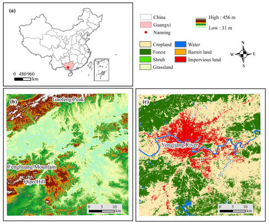
Figure 1.
Location, elevation, and LULC of Nanning. (a) Location, (b) Elevation, (c) Land Use & Land Coverage.
Nanning currently has seven districts, namely Xingning, Jiangnan, Qingxiu, Xixiangtang, Yongning, Liangqing, and Wuming. Wuming, previously administrated as a county, became a district in 2015. As Wuming has no common boundaries with the construction land in central downtown, it is excluded from the study area. There are three state-level development zones in Nanning, namely, the Nanning Hi-tech Industrial Development Zone, Nanning Economic and Technological Development Zone, and Guangxi-ASEAN Economic and Technological Development Zone. In recent years, Nanning has implemented urban development strategies of “take the Yongjiang River as the axis for the construction of the West and expansion of the East, and stress on the perfection of the north of the Yongjiang River and the upgradation of the south of the Yongjiang River, with a special focus of the southward development”, and comprehensively enhanced its radiation capacity as the central city.
Nanning is in a basin with the Yongjiang River valley in the center. The basin is surrounded by mountains and hills, with Gaofeng Peak in the north, Qipo Hill in the south, and Fenghuang Mountain in the west. Hills are mainly distributed in the marginal areas in the south, and plains are the dominant geomorphic type in this city, located in the conjunction of the lower reaches of the Zuojiang River and the Youjiang River, as well as both sides of the Yongjiang River.
2.2. Data Sources
2.2.1. Land Cover Dataset
The annual China Land Cover Dataset used in the research was obtained from Yang and Huang, characterized as providing “long period, timely update, and high precision”. The dataset is derived from 335,709 Landsat images from Google Earth Engine. Meanwhile, the authors combined the data with random forest classifier and a post-processing method that involves spatio-temporal filtering and logical reasoning to calculate the annual land cover dataset of China in 1990–2021. The land cover includes cropland, forest, shrub, grassland, water, snow/ice, barren land, impervious land, and wetland, with an overall accuracy of 80% [24]. In this study, impervious land is extracted as the urban construction land of Nanning.
2.2.2. Population Data
The Nanning resident population data from 1990 to 2020 adopted in this research were obtained from statistical yearbooks of Nanning (https://tj.nanning.gov.cn/tjsj/tjnj/, accessed on 20 December 2022). The data were from the population census or were estimated by the population sample survey, population development rate, and urbanization rate.
3. Research Methods
3.1. Spatial Expansion Mode of Urban Construction Land
Urban construction land expansion has three modes, namely, spreading expansion, infill expansion, and enclave expansion [37]. The expansion mode of new construction land N can be calculated as shown below [38]:
where LN is the side length of N, and CL is the side length of both N and current urban construction land. If E = 0, N is enclave expansion, when 0 < E < 0.5, N belongs to spreading expansion; when E ≤ 0.5, N stands for infill expansion. In general, the transition of new urban areas and rural residential areas to urban built-up areas is the main source of enclave expansion; infill expansion mainly reflects the intensive land use of urban areas; spreading expansion can be mainly observed at the margins of cities, which is regarded as a main form of outward urban expansion from the center.
In addition, through visual interpretation, this study divides spreading expansion into two types, namely, disorderly expansion and orderly expansion, and identifies finger-like expansion along roads [39].
3.2. Evaluation on Sustainable Development
SDG indicator 11.3.1 is “Ratio of land consumption rate to population growth rate” (LCRPGR); it is used in this paper to evaluate the sustainable development of Nanning. LCRPGR is calculated using the following formula (https://unstats.un.org/sdgs/metadata/, accessed on 20 December 2022):
where an LCRPGR closer to 1 showed a more balanced relationship between urban land consumption and population growth and a higher level of sustainable development. If LCRPGR is far larger than 1, this indicates high land use and a lower level of sustainable development. If LCRPGR is much smaller than 1, this demonstrates a higher compactness of urban land use. However, in this case, the roads will be much more crowded, and the living conditions also become worse accordingly, which violates the principle of sustainable development. LCR is the land consumption rate, and PGR is the population growth rate; they are calculated using the following formulas:
where Vpresent is the total built up area in the current year, Vpast is the total built up area in the past year, t is the number of years between Vpresent and Vpast (or length in years of the period considered), LN is the natural logarithm value, Popt is the total population within the urban area/city in the past/initial year, Popt+n is the total population within the urban area/city in the current/final year, and y is the number of years between the two measurement periods.
The analysis years for both the land consumption rate and the population growth rate should be the same.
4. Results
4.1. Current Spatial Distribution of Urban Construction Land
The urban construction land of Nanning was 326.33 km2 in 2021, with the largest area in Xixiangtang District (81.55 km2, 24.99%), followed by Jiangnan District (77.47 km2, 23.74%), Qingxiu District (62.01 km2, 19.00%), Liangqing District (48.74 km2, 14.94%), Xingning District (37.55 km2, 10.96%), and Yongning District (20.78 km2, 6.37%) (Figure 2).
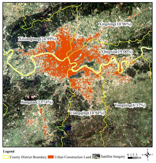
Figure 2.
Spatial distribution of urban construction land of Nanning in 2021.
4.2. Long-Term Evolution Characteristics of Urban Construction Land
4.2.1. Overall Temporal Evolution Characteristics
The evolution of construction land in Nanning from 1990–2021 reflects continuous growth (Figure 3). The construction area increased from 54.77 km2 in 1990 to 326.33 km2 in 2021, with a nearly five-fold increase. The construction land increased quickly during 1990–2020, with an annual increase of 8.95 km2, and became stable in 2021 with an area of 326.33 km2, which is 3.08 km2 higher than that of the previous year.
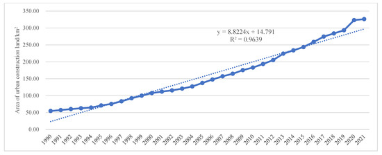
Figure 3.
Temporal evolution characteristics of construction land in Nanning from 1990 to 2021.
4.2.2. Temporal Evolution Characteristics of Each District
As can be seen from Figure 4, construction land was found to be stable in all districts during 1990–1994. The first rise was found in Xixiangtang District, with a slow increase from 1995 and rapid development from 2004. Xixiangtang’s two inflection points are both ahead of those of other districts, which makes it the most mature district. The temporal characteristics of Jiangnan and Xingning, two other mature districts, are quite similar, both with a slow increase from 1997 and a rapid development since 2005. Qingxiu, different from other districts, did not experience any slow increases. It is a district that has experienced rapid development since 1997. Liangqing demonstrated a slow increase during 1997–2010, and rapid and robust development since 2011. Yongning, with the latest development among all districts, was stable during 1990–2012 and showed a slow increase after 2013. After 2021, the construction land of all the districts tended to be stable.
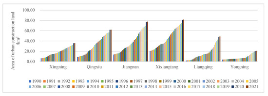
Figure 4.
Temporal evolution characteristics of each district from 1990 to 2021.
In summary, the area of construction land in Nanning from 1990 to 2021 increased by 271.56 km2. The contribution rates of three mature districts of Jiangnan, Xixiangtang, and Qingxiu are 24%, 22%, and 20%, respectively. The newly developed district—Liangqing—contributed to 17% of the increase but mainly due to its development after 2011. Xingning, another mature district, showed limited annual increases, contributing only 11% to the total increase. The rate of increase in Yongning, however, was only 6%.
4.3. Spatial Expansion Process of Urban Construction Land
As shown in Figure 5 and Figure 6, the urban construction land was mainly distributed in areas north of the Yongjiang River during 1990–1996. The city expanded northwestward during the period with several newly-built hi-tech industrial development zones. During this stage, Nanning was in a spreading expansion mode. From 1997 to 2004, the city started to expand southwestward and the Jiangnan Economic Development Zone began to take shape, with its east side reaching the east of South Lake Park. Benefitting from the infill development mode, the construction densities of Xixiangtang and Jiangnan increased, and an urban express transportation network was developed. Daxue East Road in Xixiangtang and Baisha Avenue in Jiangnan developed in a finger-like structure to the west. In this stage, Nanning experienced both chaotic spreading and infill development. The finger-like expansion along roads in Nanning was significant from 2005–2012. The main roads from northeast to southeast were Kunlun Avenue in Xingning, Minzu Avenue in Qingxiu, Yudong Avenue that stretches across both Liangqing and Yongning, and Yinhai Avenue in Liangqing. The International Convention Center along both sides of the Minzu Avenue and construction land in Fengling and Langdong Bus Station areas rapidly developed during the period. The finger-like development mode laid the foundation for the post-development of the city—the roads became traffic axes, which benefit the diversified development. During 2013–2021, newly developed urban areas expanded along the central axis of the roads. Major projects were under construction, such as the Liangqing Economic Development Zone, China–ASEAN International Logistics Terminal, and Nanning Bonded Logistics Center along the Yinhai, Yudong, and Wuxiang avenues in Liangqing and Yongning districts. All these measures increased the rate of the construction of a new urban core in southeastern Nanning. In this stage, Nanning was dominated by orderly spreading and infill expansion. In addition, Nanning has two obvious enclaves, including a functional enclave in the Wuxu airport area in Jiangnan and another one in the suburb area in Yongning. Wuxu airport experienced three reconstructions/expansions in 1990, 2014, and 2021, which also drives the construction and development of its surrounding areas. Since Yongning upgraded from a county to district, it developed westward to the main urban areas in an infill mode and merged with urban areas in 2021.
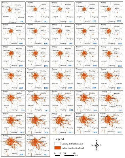
Figure 5.
Annual spatial distribution of construction land in Nanning from 1990 to 2021.
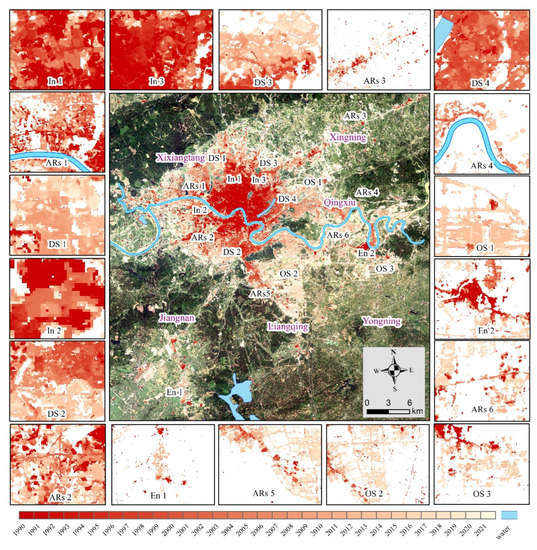
Figure 6.
Spatial expansion mode of construction land in Nanning (In, Ars, DS, OS, and En denote infill spreading, finger-like expansion along roads, disorderly spreading, orderly spreading, and enclave spreading, respectively).
In general, construction land in Nanning during 1990–2021 experienced spreading expansion, infill expansion, finger-like expansion along roads, enclave expansion, etc. Among them, spreading expansion played a leading role, and manifested as spreading from the urban center to the surrounding areas. However, the spreading direction varied in different phases, from northwest to southwest, east, and finally to southeast. Mature districts, such as Xixiangtang, Jiangnan, and Xingning were characterized as disorderly spreading (Figure 6 DS1, DS2, DS3 and DS4) with strong spatial aggregation. Newly developed districts, such as Liangqing and Yongning, showed orderly spreading (Figure 6 OS1, OS2, and OS3), with well-regulated spatial distribution. Finger-like spreading along roads can be clearly seen during the rapid development period of Nanning (Figure 6 ARs1, ARs2, ARs3, ARs4, ARs5, and ARs6). Mature districts, such as Xixiangtang and Jiangnan experienced infill expansion (Figure 6 In1, In2, and In3), and lands are intensively used under this mode. Nanning has the functional enclave of Wuxu International Airport (Figure 6 En1) and the suburban enclave of Pumiao town (Figure 6 En2).
4.4. Evaluation of Urban Sustainable Development
4.4.1. Overall SDG 11.3.1 Evaluation
When comparing LCRPGR year by year, it is difficult to avoid statistical and monitoring errors, and it is also difficult to reveal the change rule of LCRPGR. Therefore, this study used 5-year LCRPGR for municipal analysis. During the study period, LCRPGR in Nanning declined from high to low, and kept stable (Table A1 and Figure 7). One peak period was identified at around 1995, indicating that during these years, construction land expansion was far beyond the demands brought about by population growth. Meanwhile, land use intensity was relatively low, and the sustainable development level was also not satisfactory. The LCRPGR was comparatively stable during other years (LCRPGR has declined after 2000 especially), with a highly balanced relationship between construction land expansion and population growth and a high intensity of land use, which showed that the sustainable development level gradually improved due to the adjustments to development plans. During the study period, LCRPGR was still at a positive level with no negative data observed, which reveals that the traffic and living conditions were good.
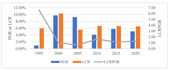
Figure 7.
Curve of LCRPGR in Nanning.
4.4.2. District-Based SDG 11.3.1 Evaluation
As there were no population data for each district before 2015, the change in statistical methods in 2020 caused data mutation, and the data for 2021 have not been released yet, this paper used data for each district between 2016 and 2019 to carry out the SDG 11.3.1 evaluation (Table A2).
As indicated by Figure 8, the LCRPGR of mature districts is characterized as an N shape, experiencing a phase of “increase–decrease–increase”. The PGR of mature districts tended to be more stable with an average of lower than 2%. The above information shows that the population of mature districts became more saturated, and its growth also slowed down. However, construction land has continuously increased. In 2019, the increase in LCR led to an increase in the LCRPGR of Xixiangtang and Xingning with a slight risk to sustainable development.
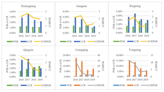
Figure 8.
Curve of LCRPGR of each district in Nanning from 2016 to 2019.
The LCRPGR of Liangqing and Yongning, two newly developed districts, declined from a very high level and tended to become stable afterwards. As can be analyzed from PGR and LCR, the construction land of the two districts were still in a period of rapid increase. The average LCR of the two districts was higher than 10%. Therefore, the LCRPGR was higher than 5 in this period. Without the guidance of plans and policies, the LCRPGR of newly developed districts tends to increase with the rapid expansion of construction land. There are some potential high risks in terms of sustainable development.
5. Discussion
5.1. Comparison with Previous Research
The laws of development of urban construction land in Nanning show high consistency with the results from previous studies [40,41,42], which verifies the reliability of this study. Other studies, however, on the basis of the yearly statistical data of construction land, focused more on the temporal change of the area but ignored the spatial visualization, or were conducted on the basis of data achieved every five years or every ten years, and the relatively long time slots may lead to unpredictable errors compared with the real situation. Relatively speaking, this paper is able to examine the spatio-temporal expansion in a more precise way and integrate the land use with the evaluation of the SDGs to provide reference for the administrations and policy makers of the city.
5.2. Influence of Development Strategies on the Evolution of Construction Land Expansion in Nanning City
According to Figure 3, Figure 5 and Figure 9, it can be seen that international-, national-, and city-level strategies jointly influence urban construction land expansion in Nanning City. The main strategies at the international level include UN MDGs and UN SDGs (Figure 9), which are global macro frameworks that do not have a significant and direct impact on the change of construction land in Nanning City, but they guide the direction of national and city level planning, e.g., the focus of both national and city level planning shifted from production to production–living–ecology since 2000.
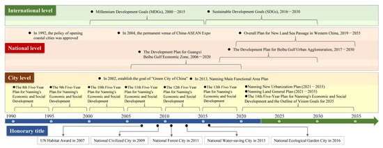
Figure 9.
Nanning’s urban development policies and its awards.
At the national level, the implementation of the Opening Coastal City in 1992 and the permanent Venue of the China–ASEAN Expo in 2004 (Figure 9) both caused a rapid growth in construction land in Nanning; after two or three years of policy enactment, annual growth rates increased from around 4% to around 9%, which had a highly significant impact. The “Development Plan for Guangxi Beibu Gulf Economic Zone” and the “Development Plan for Beibu Gulf Urban Agglomeration” all illustrate the core status of Nanning in facing ASEAN. Nanning will be finally built into a megalopolis and an international border city. The “Outline of the 14th Five-Year Plan for National Economic and Social Development (2021–2025) and Vision 2035 of Guangxi Zhuang Autonomous Region” proposes that we should focus on the high-standard construction of the Nanning metropolitan area and enhance Nanning’s comprehensive functions as the core city. The policies are opportunities for Nanning’s development, which promotes the expansion of construction land.
City-level plans are more specific and directly determine the speed and direction of urban expansion, such as the establishment of the High-tech Development Zone and the Jiangnan District Economic Development Zone in 1992, which led to a significant increase in the construction land in Xixiangtang and Jiangnan districts from 1995 to 2000, and annual growth rates increased from around 3% to around 8%. The construction projects of the city ring road from 2000 to 2005 then led to the expansion of the eastern region of the city. Fengling residential area was completed at that time, and the construction land in Qingxiu District increased by 11%. Since the municipal government released the “Nanning Wuxiang New Area Conceptual Master Plan” in 2006, Nanning started to develop mainly towards the southeast, as Liangqing Economic Development Zone, China–ASEAN International Logistics Base, Nanning Bonded Logistics Center, and other major projects were established, which accelerated the pace of setting up a new core of the city in the southeast. Since 2011, the growth rate of construction land in Liangqing District and Yongning District has increased from about 4% to more than 10%, and Yongning District even reached 23.37% in 2013.
As can be seen, international, national, and city plans are jointly driving the expansion of the construction land in Nanning from different angles and with different intensities.
5.3. Insights for the Sustainable Development of Emerging Major Cities
This study shows that the sustainability risk of cities stems mainly from the blind expansion of construction land, especially the mismatch between construction land expansion and population concentration in newly developed urban areas. This is consistent with a global study on 120 cities shows that urban land cover has, on average, grown more than three times as much as the urban population [43]. This type of urban growth turns out to violate every premise of sustainability that an urban area could be judged by, including impact on the environment and causing other negative social and economic consequences such as increasing spatial inequalities and a lessening of economies of agglomeration.
Cities require an orderly urban expansion that makes the land use more efficient. They need to plan for future internal population growth and city growth resulting from migrations. They also need to accommodate new and thriving urban functions such as transportation routes, etc., as they expand. This shows that, in the context of the rapid expansion of construction land, China’s emerging major cities are attempting to become sustainable through policy formulation and implementation. They plan land use in advance, delimit urban boundaries outward, strengthen environmental management inward, and they have achieved some effectiveness.
For example, Nanning has not developed at the expense of the environment; instead, much emphasis is placed on the people-centered development mode. Soon after the MDGs were proposed by the United Nations, Nanning took the lead in proposing the goal of building Nanning City as “China’s Green City” in 2002, and promoted the construction of “China’s Green City” in accordance with the idea of the “green trees, blue water, blue sky and tranquility” project. Since then, the LCRPGR of Nanning has dropped from an unsustainable high risk of nearly 7 to a balanced development level of 1, and it has remained so far. Although about 271.56 km2 of forest land and cultivated land in Nanning was converted into construction land from 1990 to 2021, the green land rate of urban built-up areas, green coverage rate, and per capita green area in the parks are 35.15%, 40.90%, and 12.20 m2 (http://sub.gxnews.com.cn/staticpages/20210630/newgx60dc42e5-20333102.shtml, accessed on 20 December 2022), respectively, which are all above the national average. “Nanning Main Functional Area Plan” was released in 2013, which outlined the spatial layout of the city’s population, industry, and economy, clarified the functional positioning of each town, proposed regional policies for classification and management, and promoted the formation of a rational and orderly spatial development pattern. As a result, in recent years, Nanning received several honorary awards, such as the UN Habitat Scroll of Honor Award and National Ecological Garden City award. It perfectly reflects Nanning’s social justice and inclusiveness, safety and harmony, and comfortability and livability aim, as well as its suitability as a positive human settlement for sustainable development. In addition to Nanning, China’s emerging major cities have learned from the development experiences and lessons of developed cities and pay attention to the ecological environment and sustainable development policies, such as Qingdao, which has become the most “low-carbon” city in northern China by incorporating carbon peak and carbon neutral targets into the overall layout of urbanization [44]. Another example is Zhuhai, proposed as a “waste-free city” construction pilot implementation plan to promote the harmless treatment of industrial, agricultural, and domestic solid waste and to promote sustainable urban development and green transformation [45]. At the same time, the Chinese government issued the “National New-type Urbanization Plan (2014–2020) and the National New-type Urbanization Plan (2021–2035)” [46,47] and delimited ecological protection redlines and major function-oriented zoning, which supports the goal of enhancing the capacity of urban sustainable development significantly and demarcating the urban boundaries comprehensively. The government also guides all cities, especially the rapidly developing emerging major cities, to develop to a high quality through the evaluation of National Sustainable Development City, National Ecological Garden City, National Civilized City, and National Forest City, etc.
6. Conclusions
This paper adopts 30 m annual remote sensing land cover datasets from 1990–2021 to reconstruct continuous long time series of construction land distribution, elaborately analyze the temporal evolution and spatial expansion of construction land, and evaluate the sustainable development level of Nanning based on SDG 11.3.1. The main conclusions that can be drawn are as follows:
- (1)
- In 2021, the construction land in Nanning was 326.33 km2 and was mainly distributed in Xixiangtang (24.99%), Jiangnan (23.74%), and Qingxiu (19%).
- (2)
- During 1990–2021, the construction land area in Nanning rose from 54.77 km2 to 326.33 km2—representing a nearly five-fold increase. The inflection point varied from district to district, but all the districts became stable after 2021, largely because of COVID-19. The expansion of urban construction land has slowed down due to the pandemic, and Nanning will still be in its rapid increase stage after the pandemic.
- (3)
- The spatial expansion of construction land in Nanning from 1990–2021 experienced several modes of spreading expansion, infill expansion, finger-like expansion along roads, and enclave expansion, among which spreading expansion was the most dominant. The city has experienced a “northwestward–southwestward–eastward–southeastward” spread. Mature districts spread in a disorderly way with strong spatial aggregation, while newly developed ones spread in an orderly way with regular spatial distribution. Finger-like development along roads is a distinguishing feature during the rapid development of the construction land in Nanning. When mature districts experienced infill expansion, their land use tended to become more intensive. Nanning includes functional and suburban enclaves. Nanning’s urban areas will expand to southeastern Liangqing and Yongning.
- (4)
- During the 32-year study period, the LCRPGR of Nanning declined with one peak period of around 1995, which means that during this period, the sustainable development level was low. In the remaining years, the LCRPGR was relatively stable, and construction land expansion and population growth were relatively balanced, with a high sintensity of land use. This proves that Nanning’s sustainable development level has been improved due to the adjustments to the plans.
Urban construction land changes frequently. Compared with traditional sparse time series monitoring, continuous long duration data are more suitable for urban construction land monitoring. Sparse time series data monitoring may lead to unforeseen errors between the analysis process and the real construction land change. Continuous long duration data can help to accurately reconstruct and identify the time nodes and spatial distribution of urban construction land expansion, test the effectiveness of urban management in the past, and grasp the expansion trend of urban construction land, so as to facilitate decision makers to respond in a timely manner. At present, the development of continuous long duration data has provided sufficient conditions for the research paradigm of continuous long duration monitoring of urban construction land.
The development of urban development strategies is highly important for the realization of sustainable development goals. On the one hand, the adjustment of the development strategy will affect the gradual improvement of the sustainable development level of the whole city; on the other hand, newly developed urban areas are active in emerging major cities. It can be seen that, in the future, the newly developed urban areas will have foreseeable sustainable development high risks. Therefore, policymakers need to formulate forward-looking development policies in advance.
Author Contributions
Conceptualization, Z.L.; data curation, Y.L. (Yurong Ling); formal analysis, W.J.; funding acquisition, W.J.; investigation, C.L.; methodology, W.J. and Z.L.; resources, C.L.; supervision, W.J.; visualization, Z.L. and Y.L. (Yurong Ling); writing the original draft, Z.L.; writing—review and editing, Z.Z.; validation, Y.L. (Yuan Lu). All authors have read and agreed to the published version of the manuscript.
Funding
This research was funded by the National Natural Science Foundation of China (Grant No. 42101369, No. U21A2022, No.42071393, and No. 42164001), 2021 Hangtian Hongtu Ministry of Education’s cooperative education project: “Resources and Environment Remote Sensing Information Engineering Innovation Joint Laboratory” and High-Resolution Earth Observation System Project (No. 84-Y50G25-9001-22/23).
Data Availability Statement
Publicly available datasets were analyzed in this study. These data can be found here: https://doi.org/10.5281/zenodo.581659, accessed on 20 December 2022. https://tj.nanning.gov.cn/tjsj/tjnj/, accessed on 20 December 2022.
Acknowledgments
The authors wish to thank the academic editor and two anonymous referees for their very professional reviews and quite useful suggestions, which greatly help us to improve the original version of this paper.
Conflicts of Interest
The authors declare no conflict of interest.
Appendix A

Table A1.
Data of population, construction land, and sustainable development in Nanning.
Table A1.
Data of population, construction land, and sustainable development in Nanning.
| Year | Population (10,000 People) | UCL (km2) | PGR | LCR | LCRPGR |
|---|---|---|---|---|---|
| 1990 | 105.99 | 54.77 | —— | —— | —— |
| 1995 | 110.85 | 71.02 | 0.90% | 5.93% | 6.61 |
| 2000 | 180.55 | 107.53 | 9.76% | 10.28% | 1.05 |
| 2005 | 286.58 | 137.46 | 9.24% | 5.57% | 0.60 |
| 2010 | 351.22 | 183.11 | 4.07% | 6.64% | 1.63 |
| 2015 | 468.47 | 243.66 | 5.76% | 6.61% | 1.15 |
| 2020 | 603.10 | 323.25 | 5.05% | 6.53% | 1.29 |

Table A2.
Data of population, construction land, and sustainable development in various districts of Nanning.
Table A2.
Data of population, construction land, and sustainable development in various districts of Nanning.
| Content | Year | Xingning | Qingxiu | Jiangnan | Xixiangtang | Liangqing | Yongning |
|---|---|---|---|---|---|---|---|
| Population (10,000 people) | 2014 | 41.77 | 75.68 | 60.20 | 119.44 | 36.38 | 27.52 |
| 2015 | 42.20 | 76.68 | 60.97 | 120.27 | 36.80 | 27.80 | |
| 2016 | 42.89 | 77.75 | 62.68 | 121.77 | 37.02 | 28.16 | |
| 2017 | 43.54 | 79.17 | 64.03 | 123.38 | 37.61 | 28.58 | |
| 2018 | 44.78 | 80.80 | 65.86 | 124.81 | 38.47 | 29.26 | |
| 2019 | 45.80 | 82.86 | 67.13 | 126.20 | 39.30 | 29.70 | |
| 2020 | 61.63 | 112.58 | 99.11 | 164.57 | 58.84 | 33.27 | |
| UCL (km2) | 2014 | 27.04 | 49.00 | 56.84 | 65.00 | 25.03 | 10.96 |
| 2015 | 27.75 | 50.22 | 59.05 | 66.75 | 27.56 | 12.34 | |
| 2016 | 28.78 | 52.19 | 62.59 | 68.66 | 32.37 | 14.16 | |
| 2017 | 30.07 | 54.37 | 65.81 | 71.13 | 37.04 | 16.08 | |
| 2018 | 31.04 | 55.60 | 67.72 | 72.85 | 39.39 | 17.38 | |
| 2019 | 31.97 | 56.69 | 69.40 | 74.44 | 42.35 | 18.40 | |
| 2020 | 35.44 | 61.71 | 76.77 | 81.03 | 47.92 | 20.37 | |
| 2021 | 35.77 | 62.01 | 77.47 | 81.55 | 48.74 | 20.78 | |
| PGR | 2015 | 1.02% | 1.31% | 1.27% | 0.69% | 1.15% | 1.01% |
| 2016 | 1.62% | 1.39% | 2.77% | 1.24% | 0.60% | 1.29% | |
| 2017 | 1.50% | 1.81% | 2.13% | 1.31% | 1.58% | 1.48% | |
| 2018 | 2.81% | 2.04% | 2.82% | 1.15% | 2.26% | 2.35% | |
| 2019 | 2.25% | 2.52% | 1.91% | 1.11% | 2.13% | 1.49% | |
| 2020 | 29.69% | 30.65% | 38.96% | 26.55% | 40.36% | 11.35% | |
| LCR | 2015 | 2.64% | 2.48% | 3.89% | 2.69% | 10.09% | 12.53% |
| 2016 | 3.72% | 3.94% | 5.99% | 2.86% | 17.47% | 14.76% | |
| 2017 | 4.49% | 4.17% | 5.16% | 3.60% | 14.42% | 13.62% | |
| 2018 | 3.22% | 2.26% | 2.89% | 2.42% | 6.35% | 8.03% | |
| 2019 | 2.98% | 1.96% | 2.49% | 2.18% | 7.51% | 5.87% | |
| 2020 | 10.85% | 8.87% | 10.61% | 8.85% | 13.16% | 10.76% | |
| 2021 | 0.95% | 0.48% | 0.92% | 0.63% | 1.71% | 2.01% | |
| LCRPGR | 2015 | 2.58 | 1.89 | 3.06 | 3.88 | 8.79 | 12.38 |
| 2016 | 2.29 | 2.84 | 2.16 | 2.31 | 29.31 | 11.47 | |
| 2017 | 2.99 | 2.30 | 2.42 | 2.74 | 9.12 | 9.20 | |
| 2018 | 1.15 | 1.11 | 1.02 | 2.10 | 2.81 | 3.41 | |
| 2019 | 1.32 | 0.78 | 1.31 | 1.97 | 3.52 | 3.93 | |
| 2020 | 0.37 | 0.29 | 0.27 | 0.33 | 0.33 | 0.95 |
References
- El Garouani, A.; Mulla, D.J.; El Garouani, S.; Knight, J. Analysis of urban growth and sprawl from remote sensing data: Case of Fez, Morocco. Int. J. Sustain. Built Environ. 2017, 6, 160–169. [Google Scholar] [CrossRef]
- McDonald, R.I.; Green, P.; Balk, D.; Fekete, B.M.; Revenga, C.; Todd, M.; Montgomery, M. Urban growth, climate change, and freshwater availability. Proc. Natl. Acad. Sci. USA 2011, 108, 6312–6317. [Google Scholar] [CrossRef]
- Zhang, W.; Villarini, G.; Vecchi, G.A.; Smith, J.A. Urbanization exacerbated the rainfall and flooding caused by hurricane Harvey in Houston. Nature 2018, 563, 384–388. [Google Scholar] [CrossRef]
- Grimm, N.B.; Faeth, S.H.; Golubiewski, N.E.; Redman, C.L.; Wu, J.; Bai, X.; Briggs, J.M. Global change and the ecology of cities. Science 2008, 319, 756–760. [Google Scholar] [CrossRef] [PubMed]
- Creutzig, F.; Baiocchi, G.; Bierkandt, R.; Pichler, P.P.; Seto, K.C. Global typology of urban energy use and potentials for an urbanization mitigation wedge. Proc. Natl. Acad. Sci. USA 2015, 112, 6283–6288. [Google Scholar] [CrossRef] [PubMed]
- Moore, M.; Gould, P.; Keary, B.S. Global urbanization and impact on health. Int. J. Hyg. Environ. Health 2003, 206, 269–278. [Google Scholar] [CrossRef]
- United Nations. Transforming Our World: The 2030 Agenda for Sustainable Development; United Nations: New York, NY, USA, 2015. [Google Scholar]
- Estoque, R.C.; Ooba, M.; Togawa, T.; Hijioka, Y.; Murayama, Y. Monitoring global land-use efficiency in the context of the UN 2030 Agenda for Sustainable Development. Habitat Int. 2021, 115, 102403. [Google Scholar] [CrossRef]
- Melchiorri, M.; Pesaresi, M.; Florczyk, A.J.; Corbane, C.; Kemper, T. Principles and applications of the global human settlement layer as baseline for the land use efficiency indicator—SDG 11.3. 1. ISPRS Int. J. Geo-Inf. 2019, 8, 96. [Google Scholar] [CrossRef]
- Schiavina, M.; Melchiorri, M.; Corbane, C.; Florczyk, A.J.; Freire, S.; Pesaresi, M.; Kemper, T. Multi-scale estimation of land use efficiency (SDG 11.3. 1) across 25 years using global open and free data. Sustainability 2019, 11, 5674. [Google Scholar] [CrossRef]
- Nicolau, R.; David, J.; Caetano, M.; Pereira, J.M. Ratio of land consumption rate to population growth rate—Analysis of different formulations applied to mainland Portugal. ISPRS Int. J. Geo-Inf. 2018, 8, 10. [Google Scholar] [CrossRef]
- Mudau, N.; Mwaniki, D.; Tsoeleng, L.; Mashalane, M.; Beguy, D.; Ndugwa, R. Assessment of SDG indicator 11.3. 1 and urban growth trends of major and small cities in South Africa. Sustainability 2020, 12, 7063. [Google Scholar] [CrossRef]
- Jiang, H.; Sun, Z.; Guo, H.; Weng, Q.; Du, W.; Xing, Q.; Cai, G. An assessment of urbanization sustainability in China between 1990 and 2015 using land use efficiency indicators. NPJ Urban Sustain. 2021, 1, 34. [Google Scholar] [CrossRef]
- Hamidi, S.; Ewing, R. A longitudinal study of changes in urban sprawl between 2000 and 2010 in the United States. Landsc. Urban Plan. 2014, 128, 72–82. [Google Scholar] [CrossRef]
- Yang, Y.; Feng, Z.; Zhao, Y.; You, Z. Coordination between urban land expansion and population growth in China. Geogr. Res. 2013, 32, 1668–1678. [Google Scholar]
- Huang, X.; Li, J.; Yang, J.; Zhang, Z.; Li, D.; Liu, X. 30 m global impervious surface area dynamics and urban expansion pattern observed by Landsat satellites: From 1972 to 2019. Sci. China Earth Sci. 2021, 64, 1922–1933. [Google Scholar] [CrossRef]
- Hou, Y.; Kuang, W.; Dou, Y. Analysis of urban expansion and fractal featuresin global 33 megacities from 2000–2020. Acta Geogr. Sin. 2022, 77, 2687–2702. [Google Scholar]
- Kuang, W.; Liu, J.; Dong, J.; Chi, W.; Zhang, C. The rapid and massive urban and industrial land expansions in China between 1990 and 2010: A CLUD-based analysis of their trajectories, patterns, and drivers. Landsc. Urban Plan. 2016, 145, 21–33. [Google Scholar] [CrossRef]
- Ouyang, X.; Zhu, X. Spatio-temporal characteristics of urban land expansion in Chinese urban agglomerations. Acta Geogr. Sin. 2020, 75, 571–588. [Google Scholar]
- Gong, P.; Li, X.; Zhang, W. 40-Year (1978–2017) human settlement changes in China reflected by impervious surfaces from satellite remote sensing. Sci. Bull. 2019, 64, 756–763. [Google Scholar] [CrossRef]
- Liu, X.P.; Hu, G.H.; Chen, Y.M.; Li, X.; Xu, X.; Li, S.; Pei, F.; Wang, S. High-resolution multi-temporal mapping of global urban land using Landsat image based on the Google Earth Engine Platform. Remote Sens. Environ. 2018, 209, 227–239. [Google Scholar] [CrossRef]
- Liu, H.; Gong, P.; Wang, J.; Clinton, N.; Bai, Y.; Liang, S. Annual dynamics of global land cover and its long-term changes from 1982 to 2015. Earth Syst. Sci. Data 2020, 12, 1217–1243. [Google Scholar] [CrossRef]
- Gong, P.; Li, X.; Wang, J.; Bai, Y.; Chen, B.; Hu, T.; Liu, X.; Xu, B.; Yang, J.; Zhang, W.; et al. Annual maps of global artificial impervious area (GAIA) between 1985 and 2018. Remote Sens. Environ. 2020, 236, 111510. [Google Scholar] [CrossRef]
- Yang, J.; Huang, X. The 30 m annual land cover datasets and its dynamics in China from 1990 to 2021. Earth Syst. Sci. Data 2021, 13, 3907–3925. [Google Scholar] [CrossRef]
- Jia, K.; Chen, S.S.; Jiang, W.G. Long time-series remote sensing monitoring of mangrove forests in the Guangdong-Hong Kong-Macao Greater Bay Area. Natl. Remote Sens. Bull. 2022, 26, 1096–1111. [Google Scholar]
- Bryan, B.A.; Gao, L.; Ye, Y.; Sun, X.; Connor, J.D.; Crossman, N.D.; Stafford-Smith, M.; Wu, J.; He, C.; Yu, D.; et al. China’s response to a national land-system sustainability emergency. Nature 2018, 559, 193–204. [Google Scholar] [CrossRef]
- He, C.; Liu, Z.; Tian, J.; Ma, Q. Urban expansion dynamics and natural habitat loss in China: A multiscale landscape perspective. Glob. Chang. Biol. 2014, 20, 2886–2902. [Google Scholar] [CrossRef]
- Xu, M.; He, C.; Liu, Z.; Dou, Y. How did urban land expand in China between 1992 and 2015? A multi-scale landscape analysis. PLoS ONE 2016, 11, e0154839. [Google Scholar] [CrossRef]
- Zhang, Y.; Feng, Y.; Guo, G.; Wang, F.; Cai, S. The Spatio-temporal Characteristics of Construction Land Expansion in China’s Typical Urban Agglomerations in Recent 30 years: A Case Study of the Beijing-Tianjin-Hebei Urban Agglomeration and the Guangdong-Hong Kong-Macao Greater Bay Area. J. South China Norm. Univ. (Nat. Sci. Ed.) 2022, 54, 79–90. [Google Scholar]
- Sun, Z.; Li, X.; Fu, W.; Li, Y.; Tang, D. Long-term effects of land use/land cover change on surface runoff in urban areas of Beijing, China. J. Appl. Remote Sens. 2013, 8, 084596. [Google Scholar] [CrossRef]
- Yu, S.S.; Sun, Z.C.; Guo, H.D.; Zhao, X.W.; Sun, L.; Wu, M.F. Monitoring and analyzing the spatial dynamics and patterns of megacities along the Maritime Silk Road. J. Remote Sens. 2017, 21, 169–181. [Google Scholar]
- The Economist Intelligence Unit. China’s Emerging Cities; The Economist Group: Landon, UK, 2022. [Google Scholar]
- Wu, F. Emerging cities and urban theories: A Chinese perspective. In Theories and Models of Urbanization; Springer: Cham, Switzerland, 2020; pp. 171–182. [Google Scholar]
- Akinyemi, F.O.; Pontius, R.G., Jr.; Braimoh, A.K. Land change dynamics: Insights from Intensity Analysis applied to an African emerging city. J. Spat. Sci. 2017, 62, 69–83. [Google Scholar]
- IDB. Emerging and Sustainable Cities: Methodological Guide. 2014. Available online: https://issuu.com/ciudadesemergentesysostenibles/docs/methodological_guide_esci (accessed on 20 December 2022).
- UN Habitat. Urbanization and Development: Emerging Futures. In World Cities Report 2016; UN Habitat: Nairobi, Kenya, 2016; ISBN 978-92-1-133395-4. Available online: https://unhabitat.org/wp-content/uploads/2014/03/WCR-%20Full-Report-2016.pdf (accessed on 20 December 2022).
- Camagni, R.; Gibelli, M.C.; Rigamonti, P. Urban mobility and urban form: The social and environmental costs of different patterns of urban expansion. Ecol. Econ. 2002, 40, 199–216. [Google Scholar] [CrossRef]
- Huang, X.; Xia, J.; Xiao, R.; He, T. Urban expansion patterns of 291 Chinese cities, 1990–2015. Int. J. Digit. Earth 2019, 12, 62–77. [Google Scholar] [CrossRef]
- Song, P.K. Urban Planning and Urban Design; China Building Materials Industry Press: Beijing, China, 2004. [Google Scholar]
- Xu, M.J. Research on Spatial Distribution Characteristics of Development Strength of Nanning Based on Multi-Source Data; Nanning Normal University: Nanning, China, 2019. [Google Scholar]
- Huang, Z.S. Research on Spatial Expansion Law and Dynamic Factors of Construction Land in Beibu Gulf Urban Agglomeration; Guangxi University: Nanning, China, 2018. [Google Scholar]
- Li, C.X.; Deng, F.; Gong, J.; Yan, Y. Analysis of the temporal and spatial characteristics of land use dynamic changes in Nanning from 1990 to 2015. Inn. Mong. Sci. Technol. Econ. 2019, 5, 43–47. [Google Scholar]
- Blais, P. Perverse Cities: Hidden Subsidies, Wonky Policy, and Urban Sprawl; UBC Press: Vancouver, Canada, 2011. [Google Scholar]
- Qingdao Municipal Bureau of Housing and Urban-Rural Development. Qingdao New Urbanization Plan (2021–2035); Qingdao Municipal Bureau of Housing and Urban-Rural Development: Qingdao, China, 2021.
- Zhuhai Municipal People’s Government Office. Zhuhai Municipal Pilot Implementation Plan for “Waste Free City” Construction (2021–2023); Zhuhai Municipal People’s Government Office: Zhuhai, China, 2021.
- The State Council of China. National New-Type Urbanization Plan (2014–2020); The State Council of China: Beijing, China, 2014.
- The State Council of China. National New-Type Urbanization Plan (2021–2035); The State Council of China: Beijing, China, 2021.
Disclaimer/Publisher’s Note: The statements, opinions and data contained in all publications are solely those of the individual author(s) and contributor(s) and not of MDPI and/or the editor(s). MDPI and/or the editor(s) disclaim responsibility for any injury to people or property resulting from any ideas, methods, instructions or products referred to in the content. |
© 2023 by the authors. Licensee MDPI, Basel, Switzerland. This article is an open access article distributed under the terms and conditions of the Creative Commons Attribution (CC BY) license (https://creativecommons.org/licenses/by/4.0/).