Article

Multifunctional Evolution and Allocation Optimization of Rural Residential Land in China

1
School of Public Administration and Policy, Shandong University of Finance and Economics, Jinan 250014, China
2
School of Economics, Shandong University of Finance and Economics, Jinan 250014, China
3
College of Resources and Environmental Engineering, Shandong University of Agricultural Engineering, Jinan 250100, China
*
Author to whom correspondence should be addressed.
Land 2023, 12(2), 339; https://doi.org/10.3390/land12020339
Submission received: 22 December 2022 / Revised: 18 January 2023 / Accepted: 19 January 2023 / Published: 27 January 2023
(This article belongs to the Special Issue Future Evolution of the Land Use Structure of Rural Settlements)

Abstract

:
The rural residential land functions are the comprehensive embodiment of the storage quantity and structural organization of the rural man–land system. Mastering the evolution rule and allocation situation is the basis of effective rural land management and targeted poverty alleviation activities. Based on the theoretical understanding of rural residential multifunction, this paper identifies five functional types and characteristic elements uses a variety of methods to calculate to reveal the spatio-temporal differentiation and allocation and discusses the process mechanism and spatial pattern of function optimization. According to the results, during the sample period, the multifunctional index of rural residential land in China was ranked from large to small as residential function (RF), living function (LF), service function (SF), production function (PF) and ecological function (EF), and the growth rate was ranked from large to small as ecological function (EF), production function (PF), residential function (RF), living function (LF) and service function (SF), and the comprehensive function index increased by more than 50%. The distribution characteristics of all the functional indexes were basically the same. The regional performance was east > central > northeast > west, and the range of each functional index in terms of the interprovincial performance decreased; however, the convergence degree increased, and the number of provinces with comparative advantages in terms of the various functions expanded to more than 50%. The living, ecological, and comprehensive functions increased, while the residential, production, and service functions decreased. The continuous deprivation of the functions and their deprivation in many provinces are problems. This study can provide decision support for promoting the normalization and standardization of superior rural functions.

1. Introduction

Any geographical space that is used to host human activities has multifunctional properties [1]. At present, the latest international research on land-use/land-cover change (LUCC) is transitioning from an emphasis on the change in the land-use structure or pattern to an emphasis on the multifunction evolution and sustainability of land use [2]. The purposes are the identification and measurement of the products, services, and functions that diversified land use provides [3], as well as the environmental and socioeconomic benefits that it produces, to achieve scientifically managed land use [4]. As the geographical space in which billions of Chinese peasants live and develop [5], the rural residential land is not random but is allocated to meet the needs of human life and agricultural production [6]. Its functional properties objectively exist [7] and are diverse and varied according to different human needs. Rural residential land follows an inevitable evolutionary rule [8].
In view of the problems that have arisen in the development of rural residential land, under the guidance of the government, various departments throughout the country have carried out its regulation and management [9]. Among them, the land and resources department has vigorously carried out activities such as the renovation of rural residential land and the linking of urban and rural increases and decreases [10]. The starting point is intensive and economical land use [11], and the focus is on the pursuit of a range of land-rent and land-use indicators [12], which is a typical government action driven by interests [13]. In practice, the department often uses a simple spatial agglomeration model to deal with the diversified and complex spatial development of villages [14] and lacks research on the internal structural elements of the rural residential land and the functional needs of the different subjects [15]. In the early days, the construction department paid attention to the multifunctional development of urban areas [16]. Although urban–rural integration is the principle of planning and construction [17], the research on the rural residential land functions is still not conclusive compared with the diverse construction needs of rural residential land [18], which has resulted in a village and town planning system that is “a wall of graffiti” and is impossible to effectively implement [19]. In recent years, the agricultural department has vigorously promoted new rural construction [20]. Although it also focuses on the optimization of the rural residential environment and the construction of “one village, one product” [21], its main focus is on the development of multifunctional agriculture and the corresponding rural infrastructure construction [22], as well as the promotion of the development of villages with superior resource endowments [23]. However, it also simultaneously leaves behind poor villages that have urgent development needs [24], and it lacks an integrated development strategy that adapts to the local conditions under the guidance of multiple functions [25]. Therefore, the construction of rural residential land in China lacks overall scientific guidance and planning regulation [26], and its function evolution is basically in a spontaneous state [27]. Problems such as fuzzy functional positioning, the imbalance of the function structure, and the overlapping of the function types are widespread [28]. Some new functions are abnormally obvious [29], and the local traditional functions are hidden or annihilated [30], which has resulted in increasingly acute phenomena, such as the chaotic internal structure of the rural residential land, complex building forms [31], repeated infrastructure construction, and disorderly spatial layouts [32], which seriously conflict with the top-level ecological civilization construction strategy of “optimizing the development pattern of land and space and promoting the conservation and utilization of resources” [33].
At present, scholars have conducted extensive studies on the multifunctionality of macroscale regional, ecology, and land-use systems, as well as the multifunctionality of some of the regional structural elements, such as agriculture, cities, and cultivated land [34]. However, the multifunctionality of rural residential land has not attracted widespread attention. Researchers primarily conduct studies on rural residential land from the perspectives of geography, land science, human settlements, economics, and rural sociology, and they always focus on applied research on the pattern changes in the rural residential land, utilization evaluation, arrangement planning, and regulation and control countermeasures [35]. Although some scholars have analyzed the function types and transformation of rural settlements and rural housing land from the perspective of land use and integrated the elements of the internal and external human–land-system structures of rural residential land, the investigations into and systematic research on the multifunctionality of rural residential land are still in the early stage: from theoretical to practical exploration [36].
In fact, the rural land management and control strategies that center on spatial replacement, structural adjustment, and industrial revival all take the maximization of the function value of the rural residential land as the starting and end points [37]. Without a scientific understanding of the functional connotation and organization structure of the rural residential land, it is difficult to truly grasp the control standards for it under the complex environmental background and to take appropriate policy intervention and management measures [38]. Only by fully recognizing the functional differentiation rule of rural residential land and deeply analyzing the human demand characteristics and environment endowment conditions of its functional evolution can we effectively guide its rational regulation and sustainable utilization. Rural residential land has certain Chinese characteristics and unique institutional characteristics. It is a form of land corresponding to state-owned land, belonging to the category of collective land with welfare. However, its role is also to meet the needs of residents in rural areas for living and production. It has a systematic complex structure and multi-function characteristics, and this multi-function is closely related to the development of rural areas. The coordinated promotion of various functions plays an important role in promoting rural revitalization and development. Therefore, based on a theoretical understanding of the concept, type, and characterization elements of the multifunctionality of the rural residential land, we constructed a method system for its evaluation and allocation measurement, identified its multifunction evolution rules and allocation patterns under the comprehensive action of the human–land-system elements, and assessed the optimization mechanism and pattern of the rural residential functions based on problem orientation. This research promotes the construction of research systems for rural residential land at the theoretical level, enriches the theories and methods on the versatility and sustainable use of land resources, and provides scientific support for the related activities of the regulation and management of rural residential land at the operational level.

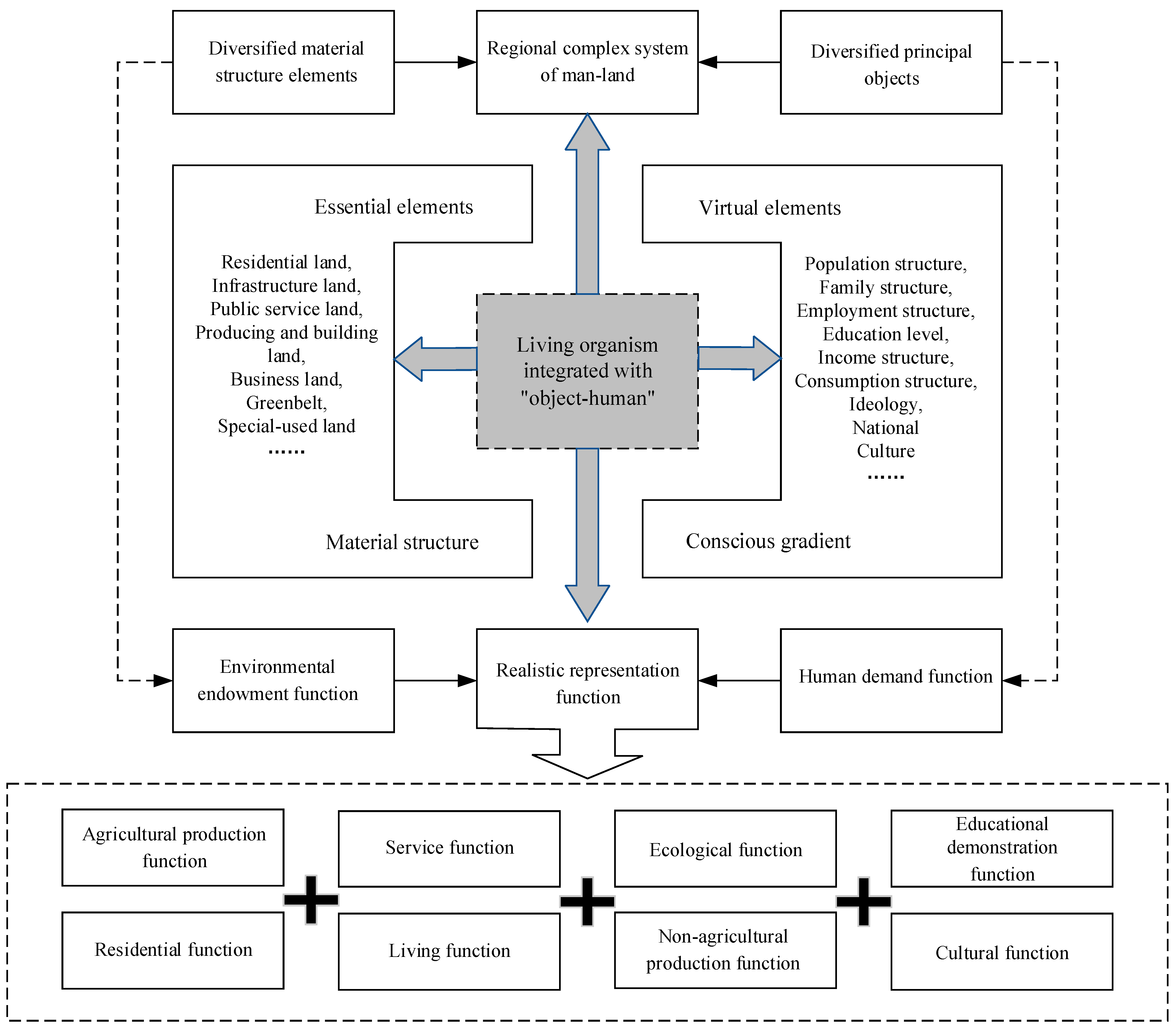
2. Theoretical Framework

Rural residential land is a living organism that integrates the “object-human” (Figure 1), and it is composed of diversified material structure elements and principal objects. The former is reflected in the subordinate nature of rural residential land (i.e., the micro-land-use type), which is composed of a fine internal structure that consists of the dominant essential elements. The latter is manifested in the carrying content of the rural residential land, which consists of the social and economic factors, such as the rural population, employment, income, consumption, ideology, and culture carried by a certain land-use form, and it has an invisible virtual quality. The material structure elements function as the regional environmental endowment, while the conscious structure elements are a function of human demand. The interaction of the two elements and the continuous coupling of the two functions form a realistic representation of rural residential land. In addition, the current research theories on the land-use, urban, agricultural, and rural regional multi-functionalities related to rural residential land are relatively mature, and the research framework and method system are relatively optimal. Therefore, in view of the characteristics of the complex rural residential land system and referring to the relevant research results, from the perspective of the subordinate properties, structure composition, and element combination, we define the concept of the rural residential land multifunctionality as a certain land-use system on rural lands that can provide beneficial products and services that meet the survival and development needs of the rural residents through the benign operation of the system and its interaction and cooperation with other systems. The rural residential land-use functions are micro-objects of expression in multifunctional land-use systems. Not only do they form the multifunctional complex of the rural land, together with the agricultural function, but they also develop into the multifunctional linkage of urban and rural lands in combination with the urban function.
In terms of the changes in the system function, the early rural residential land slowly developed under the action of the natural environment, and it had a relatively singular structure and function. Courtyard buildings functioned as living spaces and areas of primary agricultural production, and they were particularly rural. With the influence of industrialization and urbanization and the drive of the market economy, the scale of the rural residential land has rapidly increased, and the internal structure and spatial layout have undergone profound changes. The structure of the land use has developed from a relatively simple rural residential land system to a complex structure system that includes public lands, such as residential land and living and service infrastructures, and productive lands, such as for breeding, industry, and business. The spatial form has also evolved from the relatively clustered “palm” pattern to the relatively dispersed “five fingers” pattern, with the traffic and market as the gravity forces. The corresponding functions of the rural residential land have also gradually developed from a simple combination of “residence-farming” to a combination of “residence-living-service-production-ecology-culture-educational demonstration,” as well as other multiple functions, moving from homogeneous isomorphism to heterogeneous diversity, and its rural nature has gradually weakened. The formation and change process of the rural residential land functions reflect their many characteristics, such as their diversity, spatial and temporal heterogeneity, and interactivity.
The function of rural residential land is gradually formed in the process of constantly adapting to regional environmental endowments and human needs, which reflects the coupling relationship between the system structure and elements of rural residential land. Generally speaking, the rural residential system consists of land, buildings, facilities, industries, population, and other structures and specifically contains a variety of elements [39]. According to these structures and elements, rural residential land can be divided into five functional types: residence, living, service, production, and ecology. Residential function refers to the function that rural residential land can provide a suitable living environment for farmers. Living function refers to the function that can provide farmers with a more convenient life. Production function means that it can provide places for farmers to carry out agricultural breeding, industrial, commercial services, and other non-agricultural production activities. Ecological function refers to the function that can provide places and services for beautifying the rural living environment and controlling rural environmental pollution. These functions of rural residential land do not exist independently but are often interwoven and interact with each other, which makes rural residential land play multiple functions [40].

3. Research Ideas and Methodology
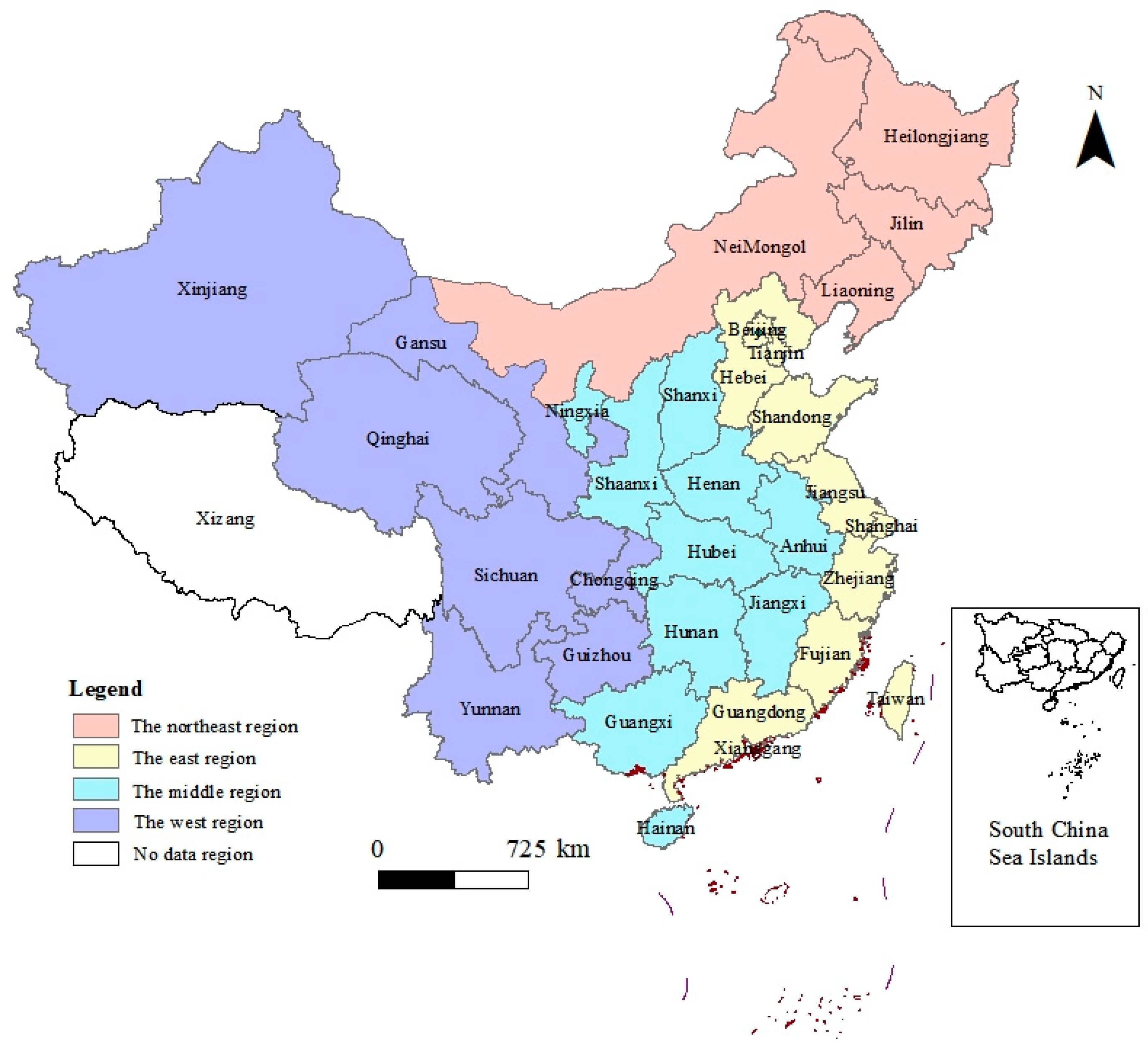
3.1. Data

Considering the impact of the change of municipal and county-level administrative divisions, it is difficult to integrate corresponding units spatially, and it is difficult to collect, process and integrate data. Therefore, we choose 31 provinces in China as the basic data carrier (excluding Hong Kong, Macao, Taiwan, and Tibet) for analysis. Through the collection and sorting of materials, it is found that the relevant data on rural residential land at the provincial level have been collected since 2006, so the study chooses 2006–2020 as the time span. At the same time, this period is an important transformation period of rural development. The documents of socialist new countryside, beautiful countryside construction, and village renovation have been successively issued. The implementation and effect of policies in each province can be reflected in the function of rural residential land, so this period is chosen for the purpose of considering and proving the effectiveness and lag of relevant policies. At the same time, the regional and provincial differences in the functional allocation of rural residential areas are affected by a variety of factors, and different factors lead to significant differences between regions. In order to further compare the differences between regions and observe the functional characteristics of different regions, referring to the existing literature [41], China’s administration is divided into four major policy areas, namely, the east, the middle, the northeast, and the west.
The basic data required for this study include rural land use, infrastructure construction, population, employment, economy, and other relevant data from various provinces in China. Among them, we collected data on rural land use and infrastructure construction from the China Land Resources Yearbook and China Urban and Rural Construction Statistical Yearbook in 2006 and 2021. We primarily gathered data on the rural population sizes, employment structures, and household incomes from the China Statistical Yearbook and China Demographic Yearbook from 2006 to 2021. Based on the obtained basic data, we completed the effective link and synthesis of the graphical data, attribute data, and time data of each province on the GIS platform, forming a multifunctional spatial attribute database for the study of the rural residential land.

3.2. Methods

3.2.1. Multifunction Indicator System for Rural Residential Land

Combined with the above basic understanding of the concept, types, and constituent elements of the rural residential land, and considering the accessibility and comparability of the statistical data on the provinces (municipalities and districts), and according to the dominance, comprehensiveness, and substitutability of the evaluation indicators and the synthesis of the essential and virtual characteristics of the elements of the rural residential land, we constructed a multifunction evaluation index system for rural residential land to assess its construction structure, infrastructure construction, service level, building structures and forms, population, employment structure, and income, expenditure, and investment levels (Table 1).
(1)
The characteristic index of the residential function. We selected four indicators to characterize the residential function: the proportion of residential land area (rf1), per capita building area (rf2), proportion of brick concrete houses (rf3), and proportion of residential reconstruction (rf4);
(2)
The characteristic index of the living function. We selected four indicators to characterize the living function: the rural road quality (lf1), traffic rate (lf2), tap water rate (lf3), and drainage pipe length (lf4);
(3)
The characteristic index of the service function. We selected two indicators to indirectly characterize the service function: the proportion of rural public building land area (sf1), representing the land use, and the proportion of public building investment (sf2), representing the capital investment;
(4)
The characteristic index of the production function. We selected five indicators to characterize the production function: the proportion of rural productive construction land area (pf1), the proportion of productive construction investment (pf2), the proportion of nonagricultural employment of peasants (pf3), the proportion of the nonagricultural income of peasants (pf4), and per capita cultivated land area (pf5);
(5)
The characteristic index of the ecological function. We selected four indicators to characterize the ecological function: the sewage treatment rate (ef1), garbage treatment rate (ef2), investment proportion of sewage and garbage treatment (ef3), and investment proportion of rural greening (ef4);

3.2.2. Multifunction Measurement Method for Rural Residential Land

(1)
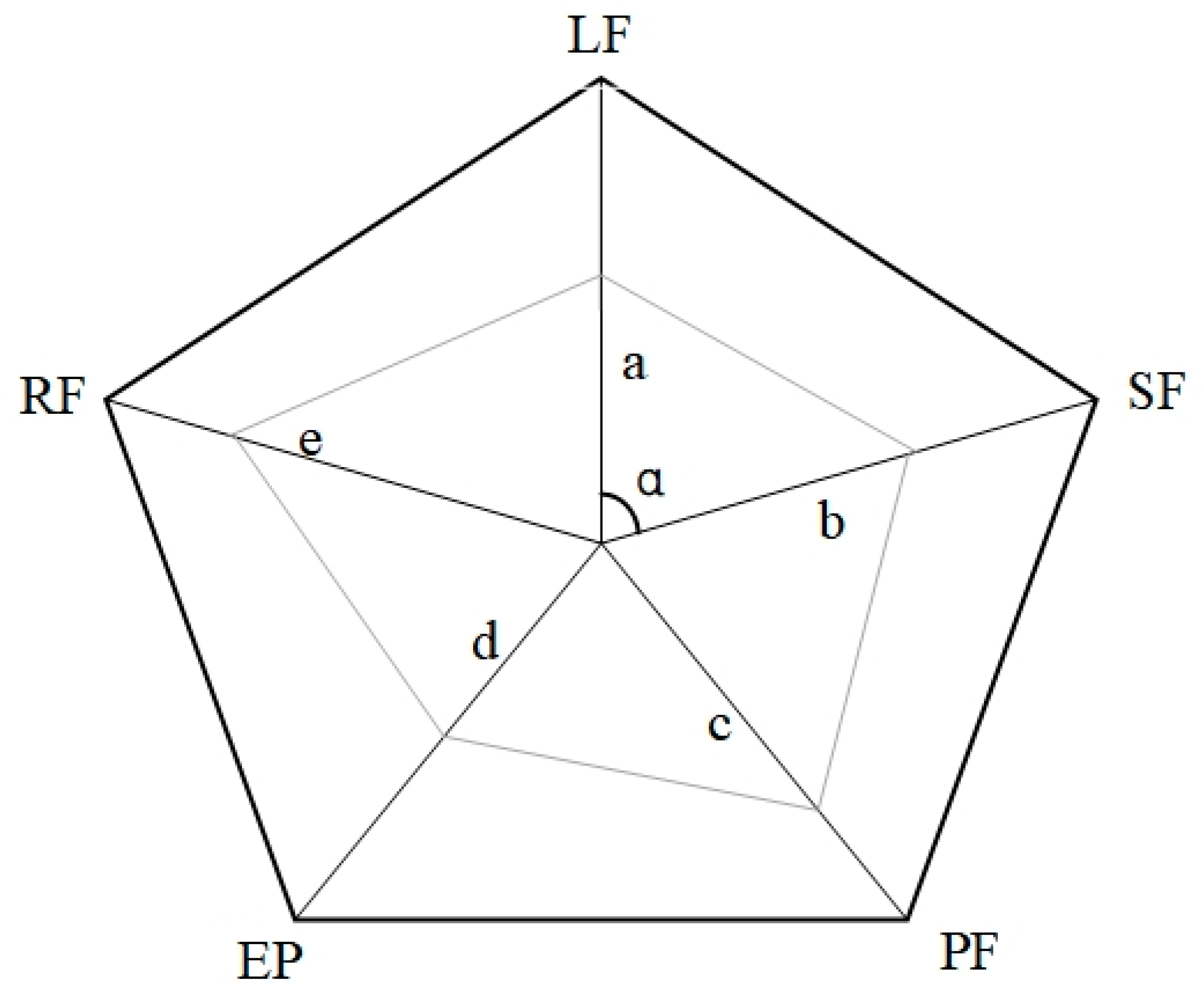
Calculation of single-function index and dominance.
Because the selected indicators have positive effects on the functions of the rural residential land, we used the forward range standardization method to standardize the evaluation indicators. We limited the value results to between 0 and 1. Then, using the dominant indicators as the main indicators and the invisible indicators as the auxiliary indicators, we integrated the entropy weight method and the Delphi method [42] to determine the weight value of each function evaluation indicator. Then, we used the weighted summation method (Formula (1)) to calculate the score of each single-function index of the rural residential land in each region:
F i = j = 1 n W i j × F i j
where Fi is the single-function index of the rural residential land; i represents the RF, LF, SF, PF, and EF; Wij is the weight value of each single-function index; Fij is the standardized score of each single-function index; j is the number of single-function indicators.
To further analyze the differences and changes in the various functions of the rural residential land in different regions, we calculated the dominance and its changes in the various functions of the rural residential land by referring to the theory of location entropy (LQ, location quotients) [43], which researchers widely use in regional economics and geography:
  L Q i = ( F i / F t )   /   ( C F i / C F t )  
Δ L Q i = L Q t i / L Q o i
where LQi is the location entropy of every single function of the rural residential land, indicating the dominance of a function in a certain region in the whole region or country; Ft is the total functions of the rural residential land, which is the summation of each functional index; CFi and CFt are the single quantity and total of the rural residential land functions in the whole region or country, respectively; ΔLQi is the time variable of the location entropy of each function; LQti and LQoi are the functional location entropies of the last time point and previous time point of a certain time period, respectively. In general, the larger the LQi, the more substantial the concentration degree of a certain function, and the more superior it is in the region. When LQi < 1, a certain function of the rural residential land in this area is at a disadvantage in the whole region or country; LQi = 1 indicates that the function is equal to the level of the whole region or country, and LQi > 1 indicates that the function is in a dominant position in the whole region or country. According to the LQoi, LQti, and ΔLQi scores and their combination of changes, we can divide the functions of the rural residential land in each region into seven types: When LQoi < 1 and ΔLQi ≤ 1, the inferior function steadily declines. When LQoi < 1 and ΔLQi > 1, the inferior function grows. At this time, if LQti > 1, then it belongs to the transition growth of the inferior function, and if LQti < 1, then it belongs to the stable growth of the inferior function. When LQoi > 1 and ΔLQi ≤ 1, the dominant function declines. At this time, if LQti > 1, then it belongs to the stable decline of the dominant function, and if LQti < 1, then it belongs to the transition decline of the dominant function. When LQoi > 1 and LQi > 1, the dominant function steadily grows. When LQti = 1, the function is stable and unchanged;
(2)
Calculation of the multifunction composite index
To isolate the incomplete substitution relationship among the five functions of the rural residential land, for the calculation of its multifunction composite index, we abandoned the previous calculation methods of simple weighting or the number of deprivation statistics and adopted the calculation method of the polygon area of mathematics [44] to integrate the five functions. The specific calculation process is as follows.
First, we established a pentagon diagram of the five functions of the rural residential land (as shown in Figure 2). We set the scores of the five functions a, b, c, d, and e, respectively, and we set the angle between any two functional scores as α. Then, we calculated the area (S) of the multifunction pentagon of the rural residential land as follows:
S = ( a b + b c + c d + d e + e a ) × sin α / 2
Due to the different ranking methods of the different functions in the calculation process, the results of the calculation were different; thus, we selected the average value of all the pentagon areas composed of the five functions as the final result. In this way, the mean value of all the pentagon areas formed by combining the five functions of the rural residential land depends on the summation of the pairwise multiplication of the five functional scores (Formula (5)), which is the multifunction composite index (Ft) of the rural residential land:
F t = a b + b c + c d + d e + e a + a c + b d + c e + d a + e b
The above equation can not only be used to calculate the multifunction composite score of the rural residential land, but it also better expresses the coordination among the different functions to enrich our understanding of the effects of the contributions of the various functions to the comprehensive function of the rural residential land. If the five functional scores of the rural residential land in a certain area are close to or more than equal, then the multifunction score of the rural residential land will be larger, indicating that the degree of polarization among the different functions of the rural residential land is low and that the development of the rural residential land is highly sustainable.

3.2.3. Optimization Method of Function Allocation of Rural Residential Land

The multifunction optimization allocation of rural residential land is the key to realizing rural development, and it is also the goal and task of the remediation of the rural residential land and the targeted poverty alleviation. The authors of China’s Village and Town Planning Standard (GB50188-93) (referred to as the “Planning Standard”) provide planning allocation standards for the structural proportions of the construction land types of the central market town, general market town, and central village. According to the structure and function principle, which states that the “structure organization reflects functional requirements, and function optimization guides structure change,” planners can use this standard as the basis for the functional optimization of the land use in the villages and towns. Considering that, in this paper, our focus is on the rural residential land use and structural characteristics of the “central village-basic village” system in China, based on the proportion of the land-use structure of the central village in the planning standard, we set the allocation standard of the various functions of the rural residential land (Table 2), and we calculated the allocation coefficient of its various functions (Formula (6)).
S C i = ( F i × μ i )   / i = 1 5   ( F i × μ i )
where SCi is the allocation coefficient of the various functions of the rural residential land, which we used to express the allocation statuses and types of the various functions, and μi is the structure correction coefficient of each function of the rural residential land, which we used to modify each function index of the rural residential land to the planning standard system for comparison with the allocation standard; its value is the limit value of the structural proportion of each type of land use in the planning standard. The correction coefficients of the RF, SF, LF, EF, and PF are 0.55, 0.12, 0.16, 0.04, and 0.13, respectively.
To effectively understand the function allocation of the rural residential land in different regions at different times, as well as its changing rules, we conducted the regression expression by using the combined coding method. The specific rules are as follows: First, we compared the function allocation coefficient with the allocation standard, and we subdivided each function into the allocation affluence type, equilibrium class, and deprivation class, which we represented with numbers 1, 2, and 3, respectively. Then, according to the changes in each function allocation type in the two periods, we further defined the dynamic allocation of each function as the sustained type, optimized type, or degenerate type, which are represented by A, B, and C, respectively. Finally, we combined the static allocation types and dynamic change types of the different functions to form the function allocation types of the rural residential land, and we coded them with “two digits + one letter.” The first digit represents the allocation type of the previous period, the second digit represents the allocation type of the subsequent period, and the letter represents the dynamic allocation type. For example, 22A indicates that a certain function behaved as a balanced continuous allocation in the two periods, and 23C indicates that the allocation was degraded from equilibrium to deprivation. At the same time, in view of the deprivation and degradation problems that exist in the different functions in different provinces and the number of problems that correspond to the five functions, according to the principle of “the more serious the problem is, the more priority it will be, the more persistent the problem will be, the more priority it will be, and the more multiple the problems will be, the more priority it will be,” we focused on the continuous deprivation and optimization of the types from degradation to deprivation (that is, according to the following optimization order: 33A–13C–23C–12C–32B–31B–21B–22A–11A), and we explored the spatial paths of the rural residential land functions (Table 3).

4. Result Analysis

4.1. Changes in Rural Residential Land Function Index

To compare the interprovincial differences in the various functions of the rural residential land, we sorted the Fi and Ft scores of all the provinces. With 0.3 and 0.6 as the critical Fi values and 1.0 and 3.0 as the critical Ft values, we divided the provinces that corresponded to the various functions into high-value areas, median-value areas, and low-value areas. In addition, we calculated the function indexes of and compared the differences among the four policy areas: the eastern, central, northeastern, and western regions. We present the results in Figure 3. China’s administrative division and regional division refer to Figure 4.
According to Figure 3a, the national RF2006 was 0.56, and the RF2020 was 0.64. From 2006 to 2020, the residential function index of the rural residential land in China increased by 14.29%, indicating that the housing quality and housing conditions of the rural residents in China had improved. In 2006, the high-RF-value areas were mainly distributed in Zhejiang, Jiangsu, and Fujian in the east, with five provinces in the middle, except for Shanxi, Sichuan, and Chongqing in the west, while the low-RF-value areas were distributed in Xinjiang and Gansu. The range of high-RF-value areas was expected to expand to 18 provinces by 2020, with the disappearance of the low-RF-value areas. The rural housing conditions had been substantially improved, indicating better conditions in the central region than in the eastern region and better conditions in the western region than in the northeast region.
According to Figure 3b, the national LF2006 was 0.35, and the land LF2020 was 0.39. From 2006 to 2020, the living function index of the rural residential land in China increased by 11.43%, indicating that the infrastructure construction, such as road traffic, water supply, and drainage in rural areas, had improved to a certain extent. In 2006, there were only five provinces with high RF values, and the low-RF-value areas covered a wide range, including all the provinces in the western region and most of the provinces in the central and northeastern regions. Sichuan, Chongqing, Guizhou, and Inner Mongolia were the most prominent low-RF-value provinces. The regional performances were as follows: eastern region > central region > northeast region > western region. By 2020, the high-LF-value areas were basically stable, and the range of low-value areas had decreased from 16 provinces to 8. The regional differences had also changed, and the northeast region surpassed the central region.
According to Figure 3c, the national SF2006 was 0.38, and the SF2020 was 0.40. From 2006 to 2020, the service function index of China’s rural residential land increased by 5.26%, indicating that the investment in the construction of rural public services and supporting facilities had improved but that the intensity was weak. In 2006, the only high-SF-value areas were Beijing and Shanghai, while the low-value areas were concentrated in the four provinces of Sichuan, Chongqing, Guizhou, and Guangxi in the west. By 2020, the high-SF-value areas had slightly expanded in the eastern provinces, while the low-SF-value areas increased in Heilongjiang and Jilin in northeast China and Yunnan in western China. The regional differences for the two periods are as follows: eastern region > central region > northeast region > western region, which indicates that, over the past 10 years, the improvement in China’s rural public service conditions has not received universal attention, and there are many problems, such as insufficient investment and construction over larger ranges.
According to Figure 3d, the national PF2006 was 0.28, and the PF2020 was 0.38. From 2006 to 2020, the production function index of the rural residential land in China increased by 35.71%, indicating that China’s rural nonagricultural industry has had a healthy development, the employment structure of the peasants has changed, and their income levels have substantially improved. In 2006, the only high-PF-value areas were Beijing and Shanghai, while the low-value areas covered almost all the provinces in the other three regions. The status of the production function of the rural residential land was low overall. By 2020, the high-PF-value areas had expanded to six provinces in the eastern region, while by 2006, the low-value areas of Liaoning, Wuhan, Chongqing, and other provinces with low PF values had increased to the median. The regional differences for the two periods are as follows: eastern region > northeast region > central region > western region, which indicates that the core content of China’s production development has been put into practice over the past 10 years and that relatively remarkable results have been achieved. However, the functional basis is poor, and there is still much room for improvement.
According to Figure 3e, the national EF2006 was 0.22, and the EF2020 was 0.37. From 2006 to 2020, the ecological function index of the rural residential land in China increased by 68.18%, indicating that the investment and transformation of rural environmental sanitation and ecological construction in China have increased, and the degree of the sewage and garbage treatment has been enhanced. In 2006, only Beijing and Shanghai had high EF values, and all the provinces in the other three regions, except for the eastern region, had low EF values. The status of the ecological function of the rural residential land was also low overall. By 2020, the high-EF-value areas concentrated in the eastern region (except for Hebei and Hainan), and the EF values of most of the provinces in the central and northeast regions, had changed to the median value, and the low-value areas were in the other western provinces, except for Shaanxi–Ningxia. The regional differences for the two periods are as follows: eastern region > central region > northeast region > western region, which indicates that, over the past 10 years, the dirty, disorderly, and poor rural environment has been improved to some extent; however, the gap between the provinces is still large.
According to Figure 3f, the national Ft2006 was 0.99, and the Ft2020 was 1.52. From 2006 to 2020, the comprehensive function index of China’s rural residential land increased by 53.54%, and the overall situation improved, which was due to the continuous improvement in the various functions. In 2006, the high FT values were Beijing and Shanghai, the median areas were concentrated in the other eastern provinces, and the low-value areas included all the provinces in the central, northeast, and western regions, which were substantially affected by the overall low production and ecological functions of the rural residential land during this period. By 2020, the high-FT-value areas had expanded to all the other provinces in the eastern region, except for Hebei and Hainan, and the low-value areas had also been reduced to only Yunnan, Guizhou, Guangxi, and Sichuan. The regional differences for the two periods are as follows: eastern region > central region > northeast region > western region, which was closely related to the natural environment, location conditions, urbanization level, economic development, emphasis on new rural construction, and implementation degree of the relevant policies of each province.

4.2. Changes in Dominance of Rural Residential Land Functions

The location entropy of the various functions of the rural residential land in China is characterized by a certain concentration of high or low values in different periods, which has resulted in regional differences in terms of dominance changes. The different types of functional changes have quantitative disequilibrium, spatial agglomerations of the dominant type, and regional dispersions of the nondominant type (Figure 5).
(1)
From 2006 to 2020, except for Shaanxi and Qinghai, the dominance of the other provinces remained in a relatively stable state, with the strong disequilibrium of the change types, which were mainly dominated by the stable decline of the dominant function and decline of the inferior function, the former of which was concentrated in four provinces in central China and four provinces in western China, and the latter of which was concentrated in seven provinces in eastern coastal China. However, two-thirds of the provinces had decreasing dominance trends;
(2)
From 2006 to 2020, the overall stability of the dominance of the living function was relatively low. Half of the provinces had the phenomenon of interacting functional advantages and disadvantages, and 13 provinces with inferior functional transformations and growth were dominant, which were concentrated in the northeast and western regions, while the other changes were relatively balanced in quantity and discrete in space. In general, four-fifths of the provinces had increasing dominance trends of dominance.
(3)
From 2006 to 2020, there were nine provinces that had the phenomenon of interacting functional advantages and disadvantages, and most of them had transitioned from advantages to disadvantages. However, the corresponding types were dominated by a stable decline in the advantages and functions. The regional distribution of the various types of changes was relatively discrete. In general, two-thirds of the provinces had changing trends of decreasing advantages;
(4)
From 2006 to 2020, only Jilin, Sichuan, and Ningxia transitioned from superior to inferior production functions, while the other provinces were relatively stable. The change types were dominated by the decline of the inferior function and the stable decline of the advantageous function, the former concentrated in the high-value areas in the east and northeast areas, and the latter concentrated in the low-value areas in the central and western areas. In general, two-thirds of the provinces had decreasing dominance trends;
(5)
From 2006 to 2020, there were only eight provinces that had the phenomenon of interacting functional advantages and disadvantages, and most of them had transitioned from disadvantages to advantages. The six types of change did not have any obvious dominances, and the largest number of the stable-growth type of the inferior function was mainly distributed in the western region, while the other types had discrete distributions among the regions. In general, the increase and decrease in interprovincial dominance accounted for half and half, respectively;
(6)
From 2006 to 2020, the comprehensive functions of five provinces had dominance interactions, and all of them transitioned from disadvantages to advantages. The change type was dominated by the stable growth of the inferior functions in 14 provinces, which are concentrated in the western region. The number of inferior function and superior functional transition change types that declined were few. The numbers of the other three types of provinces were relatively balanced, and their spatial distributions were relatively discrete. The overall trend was increasing dominance in 25 provinces.

4.3. Evolution Types of Function Configuration of Rural Residential Land

According to Table 4, the allocation of the residential function of the rural residential land in 2006 belonged to the deprivation category in six provinces, decreasing by two provinces by 2020. Chongqing and Sichuan were in states of continuous deprivation. In terms of the allocation of the living function in 2006, 10 provinces were in the deprivation category, decreasing by two provinces by 2020. The four provinces of Inner Mongolia, Sichuan, Chongqing, and Guizhou were in states of continuous deprivation. In terms of the allocation of the service function, there were three provinces in the deprivation category, increasing by one by 2020. Sichuan and Chongqing were in states of continuous deprivation. In terms of the allocation of the production function in 2006, 17 provinces belonged to the deprivation category, increasing by two provinces by 2020. Jilin, Anhui, Jiangxi, Hunan, Sichuan, Chongqing, and 14 other provinces were in states of continuous deprivation. In terms of the allocation of the ecological function in 2006, 22 provinces were in the deprivation category, decreasing by 12 by 2020. Nine provinces, including Inner Mongolia, Heilongjiang, Yunnan, Guizhou, Sichuan, and Chongqing, were in states of continuous deprivation. From 2006 to 2020, the overall allocation of the residential, living, and ecological functions on the rural residential land improved; however, the allocation of the service and production functions was slightly degraded. A gap still exists between large-scale rural public facilities, industrial development, and environmental sanitation and the goal of rural revitalization and development. At the same time, the rural residential land in various provinces has not only been persistently deprived of multiple functions, but it has also faced the deprivation or degradation of the intersection or combination of the single functions. Therefore, the optimization process should be based on problem orientation, and differentiated regulation countermeasures should be proposed.

5. Discussion

5.1. Process Mechanism of Function Optimization of Rural Residential Land

The function optimization of rural residential land is a process of adjusting or redistributing the land-use structures and corresponding social and economic factors, and it evolves along the logical path of “pressure-state-response” to realize coordinated and balanced multifunctional development. Although we have proven that the functions of the rural residential land in China have improved overall in this research and that some of the functions have also demonstrated increasing advantages and improved allocation trends, there are still relatively large regional differences, and some functions are in states of allocation deprivation or degradation and continuous disadvantage or are transitioning from superior to inferior. We need to further address the problems of the normalization of advantages and the standardization of the allocation of rural residential land. Therefore, we constructed a conceptual model of the function optimization process of rural residential land, and we analyzed the process mechanism of the function optimization to guide the strategy for the formulation and arrangement of the function optimization of rural residential land in different regions [45,46,47].
According to the model constructed in Figure 6, the management system, favorable agricultural policies, the economic environment, the technological level, the market demand, and the development strategy are the external factors of rural development, while the natural environment, resource endowment, location conditions, economic level, management ability, and human resources are the internal factors [48,49]. Rural collective organizations and villagers are the core of and direct actors in rural development. By integrating external resources and stimulating internal motivation, they can establish strategies, formulate plans, develop resources, cultivate industries, strengthen management, innovate mechanisms, and expand markets to promote the gradual improvement in and healthy development of the comprehensive rural strength [50]. On this basis, and in view of the deterioration of the rural residential functions, we need to increase the stock and update the integration of the system elements, such as rural housing, transportation, water and electricity, culture and education, medical care, old-age care, agriculture, industry, commercial services, sanitation, and greening. China should promote the rural industrial economy, social demand, facilities and buildings, ecosystem, resource supply, and spatial form of the system structure of continuous adjustment and optimization. In the new pattern of ecological balance and stability, the intensive utilization of resources, orderly spatial organization, improvements in living environments, and the coordinated development of agricultural production, the nonagricultural economy, and social undertakings, China can realize the continuous evolution and mutual promotion of the rural residential, living, service, production, and ecological system functions [51,52].
There is no unified standard for the division of multifunctional functions of rural residential land in the existing studies. This paper comprehensively uses the man-land relationship regional system theory and structural function principle, analyzes the system structure and organizational characteristics of rural residential land, defines the basic concept and bearing content of rural residential land, and identifies the multifunctional types and characterization elements of rural residential land. Existing studies have not yet made a clear understanding of the evolution law and configuration pattern of rural residential multifunction in various provinces of China. Based on the problem orientation, this paper discusses the process mechanism of the function optimization of rural residential land, constructs the function optimization pattern, and puts forward the differentiated optimization strategy, which provides a certain scientific basis for rural land management and even targeted poverty alleviation activities in practice. The content of a multifunctional evaluation system is relatively simple in most existing studies. Based on the essential and virtual characteristics of the constituent elements of rural residential land, this paper comprehensively constructs a multifunctional evaluation index system of rural residential land from the aspects of rural construction land structure, infrastructure construction, and service level, building structure and form, population and employment structure, income and expenditure and investment level, etc.

5.2. Spatial Path of Function Optimization of Rural Residential Land

The regional and interprovincial differences in the function allocation of rural residential land are affected by many factors. Except for the location conditions in the east, central, northeast, and west, the regional differentiation in terms of plains, hills, and mountains is also an important factor. The eastern and mountainous areas in the middle, west, and northeast contain many plains, and the mountainous areas are the primary areas among which the rural residential lands are distributed. Restricted by the capacity of the land environment, the rural residential lands in the mountains are scattered, closed, remote, inaccessible, and poor, which is also the main reason that the mountainous areas make up the main body of the national poverty counties of China. Therefore, the focus of the function optimization of rural residential land should be on the vast mountainous areas in the different regions and provinces [53,54]. Based on this, and on the understanding of the mechanism of the different processes of function optimization, and aiming at the spatial neighborhood relations of provinces with similar problems, we constructed the function optimization pattern of the rural residential land of “path + region,” and we propose the regional differentiation strategy (Figure 7).
The priority optimization path involves four western provinces, which are spatially divided into the Sichuan–Chongqing, and Yunnan–Guizhou regions. Among them, the rural poverty in the Sichuan–Chongqing region is relatively serious, belonging to the category of the continuous deprivation of the full functions of the rural residential land, which requires China to increase financial support and sustainable and stable preferential policies for the peasants, carry out the “ecological migration” project and comprehensive improvement in the water and soil resources, concentrate and relocate the scattered settlements from the steep slope areas to the river valleys, and promote the renovation of dilapidated rural houses, the development of infrastructure and public service systems, the cultivation of industries, and improvements in the ecological conditions. The Yunnan–Guizhou region belongs to the category of the continuous deprivation or degradation of the living, production, and ecological functions of the rural residential land. Most of the rural areas in this region are located in rocky, desertified, and border mountainous areas that are characterized by serious ecological degradation, drought and flood disasters, and poor conditions for agriculture. Ecological migration and other methods should be adopted to reduce the pressure of the population on the karst ecological environment. Attention should be paid to the development of ecological agriculture and the cultivation of new economic growth points, such as the characteristic resource industries and rural tourism, and the construction of rural infrastructure and public service systems should be promoted with economic development and industrial support [55,56,57,58].
The key optimization path includes nine provinces, which are spatially divided into the Henan–Anhui–Hubei region in the middle, the Xinjiang–Qinghai–Gansu region in the northwest, and the Jilin–Heilongjiang–Inner Mongolia region in the northeast. Among them, the Henan–Anhui–Hubei region belongs to the category of the dual functions of the continuous deprivation of the living, production, and ecology functions of the rural residential land. The rural areas in the plain regions should give full play to the advantages of their agricultural resources, develop and strengthen the deep processing of the agricultural products and nonagricultural industries, optimize the structure and layout of the rural industries, enhance the self-development ability of the rural areas, and improve the nonagricultural employment and income levels of the farmers [59]. On the basis of ensuring a safe and stable ecological environment in mountainous areas, a large number of empty villages should be combined with the construction of new rural areas, the development of modern agriculture, and improvements in the efficiency of the rural infrastructure, public service resource allocation, and rural living environment. The other two partitions belong to the category of the continuous deprivation or degradation of the dual functions of the production, living, service, and ecology functions of the rural residential land. Among them, the three northeastern provinces should focus on the revitalization of the old industrial base in the northeast and the construction of major grain commodity and animal husbandry production bases in the country, accelerate the development of agricultural modernization and rural industrialization, promote the construction of rural infrastructure and public service facilities, and strive to solve the problems among the mountain “forest people” and “grain people” and of production poverty [60]. The three western provinces should rely on the opportunities afforded by the continuous promotion of the western development policy, based on the guidance of an industrial development strategy that utilizes urbanization and ecological characteristics and encourage peasants in poor, ecologically fragile, and sparsely populated areas to move to developed areas, with larger ecological capacities and populations. The three western provinces should focus on the advantages of their regional resource and development potential, develop ecological agriculture and tourism, and build new modern rural areas in the west with the aims of ecological harmony, production development, and rich living.
The moderate optimization path includes seven provinces, which are spatially divided into the Shaanxi–Shanxi–Ningxia region and Jiangxi–Hunan–Guangxi–Hainan region. These two regions belong to the single type of continuous deprivation or degradation of the productive functions of the rural residential land. Among them, the Shaanxi–Shanxi–Ningxia region should be under the support of the policy for the development of the western region, and full play should be given to the radiating effect of the Guanzhong–Tianshui, Lanzhou–Xining, and Ningxia regions along the Yellow River Economic Zone, as well as the advantages of the agricultural resources in the valley and tableland, promoting the coordination between agricultural production and the ecological environment via soil erosion control and farmland transformation, as well as the development of the rural industry via the exploitation of the superior energy and mineral resources. The ecological reserve should appropriately develop an animal husbandry economy and rural ecological tourism, and it should orderly promote the resettlement of people from translocated areas. The Jiangxi–Hunan–Guangxi–Hainan region should take the opportunity presented by the construction of the national high-quality grain industrialization project and the shift in the labor-intensive industries from the coastal to inland areas, promote the development of modern agriculture with the construction of high-standard basic farmland, promote the development of tertiary industries based on the regional advantages of the central region, which connects the east with the west and the south with the north, and create an environment that is conducive to the development of rural industries overall [61].
The stable optimization path includes 10 provinces in the eastern coastal area. In the whole region, except for Jiangsu province, the functions of the rural residential land are ideal; however, the functions of the rural residential land in the other provinces have a certain tendency towards degradation or instability. Overall, this region has entered the stage of rural transformation and development; however, there are still substantial differences among the provinces, especially between those in the north and south. The northern coastal regions, mainly Beijing, Tianjin, Hebei, Shandong, and Liaoning, and especially the poverty-stricken areas around the capital, need more support from policies, funds, and other production factors, the development of rural experiential agriculture and sightseeing tourism, the strengthening of the construction and transformation of the rural living and ecological infrastructures, the promotion of the transformation of the rural industrial structure, and a comprehensive improvement in the quality of rural living [62]. The southern coastal region of the Yangtze River, which is dominated by Jiangsu, Shanghai, Zhejiang, Fujian, and Guangdong, should take the construction of an urban and rural equivalence as the starting point, take the external guidance of cities and towns and the endogenous growth of rural areas as the primary points, effectively integrate the rural development with the agricultural, ecological, and cultural resources, promote the joint development of high-quality planting, characteristic processing, and leisure tourism in rural areas, and strengthen the diversified rural industrial development model to realize the optimal allocation of the rural functions and values.

6. Conclusions

Based on the regional system theory of the man-land relationship and the principle of structural function, this paper makes a comprehensive analysis of the multi-functionality of rural residential land in China, which enriches the research content of land resources science and rural settlement science theoretically and provides a reference for the function optimization of rural residential land under the strategy of rural revitalization in practice. The results show that, from 2006 to 2020, the five functional indexes of rural residential land gradually change from big differences too obvious convergence, and the spatial distribution characteristics of each functional index basically converge. There are slight differences in the performance of functional changes between regions. Although the functional indexes are reduced between provinces, the degree of convergence is quite different. Excepting for the residential function, the other functions of rural residential land have changed from a few provinces with comparative advantages and concentrated in the eastern region to more than half of the provinces with comparative advantages in each function. In the change of functional dominance, the dominant types of different functions are different. In terms of the changing trend of dominance degree, the living, service, and production functions showed a trend of overall decrease, the living, and comprehensive functions showed a trend of increase, and the ecological functions showed a trend of equilibrium increase and decrease. The overall allocation of residence, living and ecological functions of rural residential land have improved, but there are some problems, such as the degradation of service and production functions of rural residential land. Therefore, based on the problem-oriented, the process mechanism of function optimization of rural residential land is discussed, a function optimization pattern is constructed, and a differentiated optimization strategy is proposed, which can provide a certain scientific basis for rural land management and even targeted poverty alleviation activities at the practical level.
In accordance with the logical thinking of “theoretical understanding—method construction—empirical application,” this paper conducts systematic research on the function of rural residential land, and the relevant results show a certain theoretical value and practical guidance. However, there are still some limitations in the research, firstly, in the research scale. Inter-province is a macro data unit. The area of each province and the actual situation of rural residential land are different, and the environment of each province is not necessarily the most suitable. Therefore, a multi-level and multi-scale research system should be established from the perspective of comprehensiveness and completeness, and micro-scale detailed research will be carried out in the future. Secondly, the selection of a multifunctional evaluation index. Although an evaluation system with a wide range of flip covers, including 19 indicators, was established in the study, some indicators were not detailed or were indirectly expressed, which may have a certain impact on the research results. Finally, the establishment of functional configuration standards. In the study, a set of measurement method systems for land function allocation is constructed by referring to the reasonable proportion of land structure for the planning of the central village. It is innovative. However, rural areas of our country are more natural villages and general administrative villages, and there is still a big gap between them and the central village, so the configuration standard will be on the high side on the whole, which may increase the probability of function allocation problems. Therefore, it will be a new research direction to establish the universal and systematic function system of rural residential land. All in all, the multi-scale process theory and law revelation about rural land use and rural transformation and development are worth further research.

Author Contributions

Conceptualization Y.Q. and M.W.; Methodology, Y.Q.; Software, Y.Q. and M.W.; validation, Y.Q. and M.W.; formal analysis, Y.Q. and M.W.; investigation, Y.Q. and L.Z.; resources, Y.Q. and L.Z.; data curation, Y.Q. and L.Z.; writing—original draft preparation, Y.Q. and M.W.; writing—review and editing, L.Z.; visualization, L.Z. and M.W.; Supervision, R.S.; Project administration, R.S.; funding acquisition, Y.Q. All authors have read and agreed to the published version of the manuscript.

Funding

This research was funded by the funding of the National Natural Science; Foundation of China (Grant No. 42077434, 41771560) and the Youth Innovation Technology Project of Higher School in Shandong Province (Grant No. 2019RWG016).

Institutional Review Board Statement

Not applicable.

Informed Consent Statement

Not applicable.

Data Availability Statement

Not applicable.

Conflicts of Interest

The authors declare no conflict of interest.

References

  1. Long, H.L.; Li, M.; Zhang, Y.N.; Qu, L.L. Multifunctional rural development in China: Pattern, process and mechanism. Habitat. Int. 2022, 121, 102530. [Google Scholar] [CrossRef]
  2. Jiang, T.H.; Shi, G.Q.; Zhang, Y.N. Multifunctional rural transition along China’s Yangtze River Transect: Spatial differentiation and economic relevance. Environ. Sci. Pollut. Res. 2021, 28, 60726–60740. [Google Scholar] [CrossRef]
  3. Jia, K.Y.; Qiao, W.F.; Chai, Y.B.; Feng, T.; Wang, Y.H.; Ge, D.Z. Spatial distribution characteristics of rural settlements under diversified rural production functions: A case of Taizhou, China. Habitat. Int. 2020, 102, 102201. [Google Scholar] [CrossRef]
  4. Ma, L.; Long, H.L.; Tu, S.S.; Zhang, Y.N.; Zheng, Y.H. Farmland transition in China and its policy implications. Land Use Policy 2020, 92, 104470. [Google Scholar] [CrossRef]
  5. Nizam, D.; Tatari, M.F. Rural revitalization through territorial distinctiveness: The use of geographical indications in Turkey. J. Rural. Stud. 2022, 93, 144–154. [Google Scholar] [CrossRef]
  6. Qin, X.F.; Li, Y.R.; Lu, Z.; Pan, W. What makes better village economic development in traditional agricultural areas of China? Evidence from 338 villages. Habitat. Int. 2020, 106, 102286. [Google Scholar] [CrossRef]
  7. Spataru, A.; Faggian, R.; Docking, A. Principles of multifunctional agriculture for supporting agriculture in metropolitan peri-urban areas: The case of Greater Melbourne, Australia. J. Rural Stud. 2020, 74, 34–44. [Google Scholar] [CrossRef]
  8. Zang, Y.Z.; Liu, Y.S.; Yang, Y.Y.; Woods, M.; Fois, F. Rural decline or restructuring? Implications for sustainability transitions in rural China. Land Use Policy 2020, 94, 104531. [Google Scholar] [CrossRef]
  9. Yang, R.; Zhang, J.; Xu, Q.; Luo, X.L. Urban-rural spatial transformation process and influences from the perspective of land use: A case study of the Pearl River Delta Region. Habitat. Int. 2020, 104, 102234. [Google Scholar] [CrossRef]
  10. Sun, P.; Zhou, L.; Ge, D.Z.; Lu, X.X.; Sun, D.Q.; Lu, M.Q.; Qiao, W.F. How does spatial governance drive rural development in China’s farming areas? Habitat. Int. 2021, 109, 102320. [Google Scholar] [CrossRef]
  11. Yang, Y.Y.; Bao, W.K.; Liu, Y.S. Coupling coordination analysis of rural production-living-ecological space in the Beijing-Tianjin-Hebei region. Ecol. Indic. 2020, 117, 106512. [Google Scholar] [CrossRef]
  12. Jiang, Y.F.; Long, H.L.; Dlves, C.; Deng, W.; Chen, K.Q.; Zhang, Y.N. Modes and practices of rural vitalisation promoted by land consolidation in a rapidly urbanising China: A perspective of multifunctionality. Habitat. Int. 2022, 121, 102514. [Google Scholar] [CrossRef]
  13. Jiang, Y.F.; Long, H.L.; Tang, Y.T.; Deng, W.; Chen, K.Q.; Zheng, Y.H. The impact of land consolidation on rural vitalization at village level: A case study of a Chinese village. J. Rural Stud. 2021, 86, 485–496. [Google Scholar] [CrossRef]
  14. Long, H.L.; Zhan, Y.N.; Ma, L.; Tu, S.S. Land Use Transitions: Progress, Challenges and Prospects. Land 2021, 10, 903. [Google Scholar] [CrossRef]
  15. Ma, W.Q.; Jiang, G.H.; Li, W.Q.; Zhou, T.; Zhang, R.J. Multifunctionality assessment of the land use system in rural residential areas: Confronting land use supply with rural sustainability demand. J. Environ. Manag. 2019, 231, 73–85. [Google Scholar] [CrossRef]
  16. Zou, L.L.; Liu, Y.S.; Yang, J.X.; Yang, S.F.; Wang, Y.S.; Zhi, C.; Hu, X.D. Quantitative identification and spatial analysis of land use ecological-production-living functions in rural areas on China’s southeast coast. Habitat. Int. 2020, 100, 102182. [Google Scholar] [CrossRef]
  17. Rallings, A.m.; Smukler, S.M.; Gergel, S.E.; Mullinix, K. Towards multifunctional land use in an agricultural landscape: A trade-off and synergy analysis in the Lower Fraser Valley, Canada. Landsc. Urban Plan. 2019, 184, 88–100. [Google Scholar] [CrossRef]
  18. Wang, B.Y.; Tian, J.F.; Wang, S.J. Process and mechanism of transition in regional land use function guided by policy: A case study from Northeast China. Ecol. Indic. 2022, 144, 109527. [Google Scholar] [CrossRef]
  19. Long, X.Y.; Guo, Y.K. Research on the function evolution and driving mechanism of rural homestead in Luxian County under the “Rural Revitalization”. Acad. Accel. 2022, 199, 969–976. [Google Scholar] [CrossRef]
  20. Zhang, Y.N.; Long, H.L.; Tu, S.S.; Ge, D.Z.; Ma, L.; Wang, L.Z. Spatial identification of land use functions and their tradeoffs/synergies in China: Implications for sustainable land management. Ecol. Indic. 2019, 107, 105550. [Google Scholar] [CrossRef]
  21. Wang, X.J.; Wang, D.Y.; Wu, S.Z.; Yan, Z.R.; Han, J.Q. Cultivated land multifunctionality in undeveloped peri-urban agriculture areas in China: Implications for sustainable land management. J. Environ. 2022, 325, 116500. [Google Scholar] [CrossRef]
  22. Fan, Y.T.; Gan, L.; Hong, C.Q.; Jessup, L.H.; Jin, X.B.; Pijanowski, B.C. Spatial identification and determinants of trade-offs among multiple land use functions in Jiangsu Province, China. Sci. Total Environ. 2021, 772, 145022. [Google Scholar] [CrossRef]
  23. Jiang, G.H.; Wang, M.Z.; Qu, Y.B.; Zhou, D.Y.; Ma, W.Q. Towards cultivated land multifunction assessment in China: Applying the “influencing factors-functions-products-demands” integrated framework. Land Use Policy 2020, 99, 104982. [Google Scholar] [CrossRef]
  24. Rodríguez Sousa, A.A.; Parra-López, C.; Barandica, J.M.; Rescia, A.J. A multifunctional assessment of integrated and ecological farming in olive agroecosystems in southwestern Spain using the Analytic Hierarchy Process. Ecol. Econ. 2020, 173, 106658. [Google Scholar] [CrossRef]
  25. Li, Y.H.; Westlund, H.; Liu, Y.S. Why some rural areas decline while some others not: An overview of rural evolution in the world. J. Rural Stud. 2019, 68, 135–143. [Google Scholar] [CrossRef]
  26. Qian, F.K.; Chi, Y.R.; Lal, P. Spatiotemporal characteristics analysis of multifunctional cultivated land: A case-study in Shenyang, Northeast China. Land Degrad. Dev. 2020, 13, 1812–1822. [Google Scholar] [CrossRef]
  27. Pérez-Soba, M.; Petit, S.; Jones, L.; Bertrand, N.; Briquel, V.; Omodei-Zorini, L.G.; Helming, K.C.C.; Farrington, J.H.; Mossello, M.T.; Wascher, D. Land use functions—A multifunctionality approach to assess the impact of land use changes on land use sustainability. In Sustainability Impact Assessment of Land Use Changes; Springer: Berlin/Heidelberg, Germany, 2008; pp. 375–404. [Google Scholar] [CrossRef]
  28. Rao, J. Comprehensive land consolidation as a development policy for rural vitalisation: Rural InSitu Urbanisation through semi socio-economic restructuring in Huai Town. J. Rural Stud. 2022, 93, 386–397. [Google Scholar] [CrossRef]
  29. Wen, Y.Y.; Zhang, Z.F.; Liang, D.; Xu, Z. Rural Residential Land Transition in the Beijing-Tianjin-Hebei Region: Spatial-Temporal Patterns and Policy Implications. Land Use Policy 2020, 96, 104700. [Google Scholar] [CrossRef]
  30. Li, H.B.; Yuan, Y.; Zhang, X.L.; Li, Z.; Wang, Y.H.; Hu, X.L. Evolution and transformation mechanism of the spatial structure of rural settlements from the perspective of long-term economic and social change: A case study of the Sunan region, China. J. Rural Stud. 2022, 93, 234–243. [Google Scholar] [CrossRef]
  31. Chen, K.Q.; Long, H.L.; Liao, L.W.; Tu, S.S.; Li, T.T. Land use transitions and urban-rural integrated development: Theoretical framework and China’s evidence. Land Use Policy 2020, 92, 104465. [Google Scholar] [CrossRef]
  32. Qu, Y.B.; Liu, M.; Zhu, W.Y.; Zhan, L.Y.; Ping, Z.L. Multifunctional spatial pattern and coordination optimization model of rural residential land. J. Nat. Resour. 2021, 36. [Google Scholar] [CrossRef]
  33. Tu, S.S.; Long, H.L. Theoretical analysis on the reconstruction of rural settlement space. Geogr. Sci. 2020, 40. [Google Scholar] [CrossRef]
  34. Ma, W.Q.; Zhu, D.L.; Jiang, G.H. Study on the transformation of rural residential land structure for rural revitalization. Geogr. Stud. 2022, 41. [Google Scholar] [CrossRef]
  35. Shang, R.; Qu, Y.B.; Jiang, H.L. Spatio-temporal characteristics and formation mechanism of rural residential transformation from the perspective of human land relationship. Resour. Sci. 2020, 42. [Google Scholar]
  36. Qu, Y.B.; Wei, S.W.; Liu, M.; Zhan, L.Y.; Li, Y.N. The Spatial Pattern and Coupling Type of Multidimensional Forms of Rural Residential Areas. J. Nat. Resour. 2019, 34. [Google Scholar] [CrossRef]
  37. Yang, H.P.; Yang, Z.X.; Xin, G.X.; Li, Y.T.; Cao, R. Multifunctional Evaluation and Optimization Strategy of Rural Residential Areas in Southwest Hilly Areas—A Case Study of Rongchang District, Chongqing. Agric. Resour. Reg. China 2020, 41. [Google Scholar]
  38. Jiang, Y.F.; Long, H.L.; Tang, Y.T. Land Renovation and Rural Revitalization: A Multifunctional Perspective of Land Use. Prog. Geogr. Sci. 2021, 40. [Google Scholar] [CrossRef]
  39. Wen, Q.; Zhang, L.; Zhu, L.; Liu, Z.J.; Li, L. Study on the Multifunctional Evolution and Revitalization Path of Rural Areas on the Loess Plateau. J. Southwest Univ. (Nat. Sci. Ed.) 2022, 44. [Google Scholar] [CrossRef]
  40. Qu, Y.B.; Wang, S.L.; Zhao, L.Y.; Qu, Y.S.; Wang, S. Multifunctional Spatial Pattern and Zoning Regulation in Rural Areas of Shandong Province. J. Agric. Eng. 2020, 36. [Google Scholar] [CrossRef]
  41. Jin, X.L.; Jiang, P.H.; Li, M.C.; Gao, Y.; Yang, L. Mapping Chinese land system types from the perspectives of land use and management, biodiversity conservation and cultural landscape. Ecol. Indic. 2022, 141, 108981. [Google Scholar] [CrossRef]
  42. Toumbourou, T. Using a Delphi approach to identify the most efficacious interventions to improve Indonesia’s forest and land governance. Land Use Policy 2020, 99, 102768. [Google Scholar] [CrossRef]
  43. Zhang, B.L.; Zhang, F.R.; Gao, Y.; Li, C.; Zhu, F.K. Multifunctional identification and spatial differentiation characteristics of rural residential areas. J. Agric. Eng. 2014, 30. [Google Scholar] [CrossRef]
  44. Qu, Y.B.; Jiang, G.H.; Zhao, Q.L.; Ma, W.Q.; Zhang, R.J.; Yang, Y.T. Geographic identification, spatial differentiation, and formation mechanism of multifunction of rural settlements: A case study of 804 typical villages in Shandong Province, China. J. Clean Prod. 2017, 166, 1202–1215. [Google Scholar] [CrossRef]
  45. Li, J.; Lo, K.; Zhang, P.Y.; Guo, M. Reclaiming small to fill large: A novel approach to rural residential land consolidation in China. Land Use Policy 2021, 109, 105706. [Google Scholar] [CrossRef]
  46. Shi, Z.H.; M, L.B.; Zhang, W.B.; Gong, M. Differentiation and correlation of spatial pattern and multifunction in rural settlements considering topographic gradients: Evidence from Loess Hilly Region, China. J. Environ. 2022, 315, 115127. [Google Scholar] [CrossRef]
  47. Li, Y.J.; He, J.H.; Yue, Q.B.; Kong, X.S.; Zhang, M.M. Linking rural settlements optimization with village development stages: A life cycle perspective. Habitat. Int. 2022, 130, 102696. [Google Scholar] [CrossRef]
  48. Lu, Y.H.; Song, W.; Lyu, Q.Q. Assessing the effects of the new-type urbanization policy on rural settlement evolution using a multi-agent model. Habitat. Int. 2022, 127, 102622. [Google Scholar] [CrossRef]
  49. Zhou, J.Z.; Hou, Q.H. Resilience assessment and planning of suburban rural settlements based on complex network. Sustain. Prod. Consum. 2021, 28, 1645–1662. [Google Scholar] [CrossRef]
  50. Dong, Y.; Cheng, P.; Kong, X.S. Spatially explicit restructuring of rural settlements: A dual-scale coupling approach. J. Rural Stud. 2022, 94, 239–249. [Google Scholar] [CrossRef]
  51. Ma, L.B.; Liu, S.C.; Tao, T.M.; Gong, M.; Bai, J. Spatial reconstruction of rural settlements based on livability and population flow. Habitat. Int. 2022, 126, 102614. [Google Scholar] [CrossRef]
  52. Ji, Z.X.; Xu, Y.Q.; Sun, M.X.; Liu, C.; Lu, L.H.; Huang, A.; Duan, Y.; Liu, L.C. Spatiotemporal characteristics and dynamic mechanism of rural settlements based on typical transects: A case study of Zhangjiakou City, China. Habitat. Int. 2022, 123, 102545. [Google Scholar] [CrossRef]
  53. Hu, Q.Y.; Wang, C. Quality evaluation and division of regional types of rural human settlements in China. Habitat. Int. 2020, 105, 102278. [Google Scholar] [CrossRef]
  54. Wang, Y.F. Morphological characteristics of rural settlements from morphogenesis perspective: A case study of rural settlements in Heilongjiang Province, China. Energy Procedia 2019, 157, 1266–1277. [Google Scholar] [CrossRef]
  55. Zhao, X.; Sun, H.B.; Chen, B.; Xia, X.H.; Li, P.F. China’s rural human settlements: Qualitative evaluation, quantitative analysis and policy implications. Ecol. Indic. 2019, 105, 398–405. [Google Scholar] [CrossRef]
  56. Lu, M.Q.; Wei, L.Y.; Ge, D.Z.; Sun, D.Q.; Zhang, Z.F.; Lu, Y.Q. Spatial optimization of rural settlements based on the perspective of appropriateness–domination: A case of Xinyi City. Habitat. Int. 2020, 98, 102148. [Google Scholar] [CrossRef]
  57. Li, H.H.; Song, W. Pattern of spatial evolution of rural settlements in the Jizhou District of China during 1962–2030. Appl. Geogr. 2020, 122, 10247. [Google Scholar] [CrossRef]
  58. Qu, Y.B.; Jiang, G.H.; Li, Z.T.; Tian, Y.Y.; Wei, S.W. Understanding rural land use transition and regional consolidation implications in China. Land Use Policy 2019, 82, 742–753. [Google Scholar] [CrossRef]
  59. Qu, Y.B.; Jiag, G.H.; Ma, W.Q.; Li, Z.T. How does the rural settlement transition contribute to shaping sustainable rural development? Evidence from Shandong, China. J. Rural Stud. 2021, 82, 279–293. [Google Scholar] [CrossRef]
  60. Zhang, L.; Wang, C.; Du, X.Z.; Wang, Z.S.; Deng, C.; Li, H.Y. The Multifunctional Division of Rural Residential Land and the Evaluation of the Difference of Farmer’s Utilization. J. Agric. Eng. 2017, 33. [Google Scholar] [CrossRef]
  61. Qu, Y.B.; Wei, S.W.; Shang, R.; Deng, J. Spatial Morphology Recognition of Rural Residential Areas Based on “Point-surface” Features. Resour. Sci. 2019, 41. [Google Scholar] [CrossRef]
  62. Qian, J.C.; Zhang, B.L.; Lian, X.Y.; Wang, Z.Y. Differentiation characteristics of production and housing spatial structure of rural residential areas under different economic gradients: A case study of Dongying City. Agric. Resour. Reg. China 2022, 43. [Google Scholar]
Figure 1. Frame diagram of the human-land-relationship system of rural residential land.
Land 12 00339 g001
Figure 2. Polygonal map of rural residential land function.
Land 12 00339 g002
Figure 3. Function index distribution of rural residential land in different provinces and regions in China.
Land 12 00339 g003
Figure 4. Map of the administrative divisions of China.
Land 12 00339 g004
Figure 5. Dominance indexes of and changes in various functions of rural residential land in different provinces of China.
Land 12 00339 g005
Figure 6. Process mechanism of function optimization of rural residential land.
Land 12 00339 g006
Figure 7. The optimized provincial pattern of rural residential land functions in China.
Land 12 00339 g007
Table 1. Multifunction evaluation index system for rural residential land.
Functional LayerIndex LayerIndex IndicatorIndex UnitIndex
Type
Index
Weight
Index
Attribute
Residential
Function
(RF)
Proportion of residential land area (rf1) House and homestead area/total land area of villagehm2Positive0.4250Dominant
Per capita building area (rf2) Residential construction area/number of rural populationm2/personPositive0.1823Recessive
Proportion of brick concrete houses (rf3) Residential area above mixed structure/real residential construction area at end of year%Positive0.2783Dominant
Proportion of residential reconstruction (rf4) Planned or reconstructed residential area/total residential construction area%Positive0.1144Recessive
Living
Function
(LF)
Rural road quality (lf1) Hardened rural road area/total rural road areahm2Positive0.3260Dominant
Traffic rate (lf2) Number of administrative villages with buses/total number of administrative villages%Positive0.1599Recessive
Tap water rate (lf3) Number of villages with public water supply/total number of villages%Positive0.2674Dominant
Drainage pipe length (lf4) Total length of rural drainage channels for collecting and discharging sewage, wastewater, and stormwaterkmPositive0.2467Dominant
Service
Function
(SF)
Proportion of rural public building land area (sf1) Combined area of rural administration, public services, healthcare, education, welfare, and cultural and scientific buildings/total land area of villagehm2Positive0.6145Dominant
Proportion of public building investment (sf2) Investment in public buildings/total investment in rural areas%Positive0.3855Recessive
Production
Function
(PF)
Proportion of rural productive construction land area (pf1) Total area of rural agricultural facilities, factories, and factory buildings for development of industrial, commercial, and foreign trade services/total land area of villagehm2Positive0.3424Dominant
Proportion of productive construction investment (pf2) Investment in productive construction/total investment in rural areas%Positive0.1204Recessive
Proportion of nonagricultural employment of farmers (pf3) Rural population employed in secondary and tertiary industries/total rural population%Positive0.1763Recessive
Proportion of nonagricultural income of farmers (pf4) Rural nonhousehold operating income/net income of farmers%Positive0.1826Recessive
Per capita cultivated land area (pf5) Cultivated area/total rural populationhectare/personPositive0.1783Recessive
Ecological
Function
(EF)
Sewage treatment rate (ef1) Number of administrative villages that treat sewage
/total number of administrative villages
%Positive0.3012Dominant
Garbage treatment rate (ef2) Number of administrative villages that handle garbage/total number of administrative villages%Positive0.2885Dominant
Investment proportion of sewage and garbage treatment (ef3) Investment in sewage and garbage treatment/total investment in rural municipal facilities%Positive0.1875Recessive
Investment proportion of rural greening (ef4) Rural landscape investment/total investment in rural municipal facilities%Positive0.2228Recessive
Table 2. Multifunction optimal allocation standard of rural residential land based on planning orientation.
Planning Land StandardFunction Configuration Standards (%) and Types
Construction Land TypeProportion of
Construction Land
Structures of Central
Village (%)
Corresponding Function TypeDeprivation TypeEquilibrium
Type
Affluence
Type
Residential building land55–70RF>7055–70<55
Public building land6–12SF<66–12>12
Road square land9–16LF<99–16>16
Park green space2–4EF<22–4>4
Industrial land8–13PF<88–13>13
Note: Planning standard does not set appropriate structural proportion of industrial land but gives the sum of structural proportions of residential buildings, public buildings, roads, squares, parks, and green land as 72–92. The sum of the optimal proportion of the four types of land-use structures given by the calculation is 87. Considering that there may be other types of land use in the villages, the approximate value of the industrial land-use structure proportion is 100 minus the sum of the optimal proportion of the four types of known land-use structures (87) and upper limit value (92).
Table 3. Path design of function optimization of rural residential land based on problem orientation.
Path SelectionProblem DegreeProblem TimeNumber of Problem ItemsCorresponding Type
Priority optimizationContinuous deprivationA≥333A
Key optimizationContinuous deprivation, or from degenerate to deprivationA or C233A or 13C, 23C
Moderate optimizationContinuous deprivation, or from degenerate to deprivationA or C133A or 13C, 23C
Stable optimizationOthersA, B, C012C, 32B, 31B, 21B, 22A, 11A
Table 4. Types and optimization levels of various functions of rural residential land in different provinces of China.
ProvinceFunctional Configuration
Types of Rural Residential Land
ProvinceFunctional Configuration Types of Rural Residential Land
RFLFSFPFEFRFLFSFPFEF
Beijing11A11A11A12C12CHenan22A22A22A33A33A
Tianjin11A12C22A11A21BHubei23C23C22A33A33A
Hebei22A11A22A32B32BHunan32B32B22A33A32B
Shanxi12C12C11A23C22AGuangdong22A12C22A22A32B
Neimonggol22A33A22A23C33AGuangxi32B22A22A33A32B
Liaoning22A22A11A22A32BHenan22A22A12C33A32B
Jilin22A32B23C33A32BChongqing33A33A33A33A33A
Heilongjiang22A32B23C23C33ASichuan33A33A33A33A32B
Shanghai11A11A12C11A11AGuizhou32B33A22A33A33A
Jiangsu22A22A22A22A21BYunnan23C22A22A33A33A
Zhejiang22A12C32B22A21BShaanxi22A32B22A33A32B
Anhui32B33A22A33A32BGansu12C23C11A12C33A
Fujian22A22A21B32B32BQinghai22A22A11A33A33A
Jiangxi22A32B22A33A32BNingxia22A21B12C23C32B
Shandong22A11A21B32B22AXinjiang12C12C11A23C23C
Disclaimer/Publisher’s Note: The statements, opinions and data contained in all publications are solely those of the individual author(s) and contributor(s) and not of MDPI and/or the editor(s). MDPI and/or the editor(s) disclaim responsibility for any injury to people or property resulting from any ideas, methods, instructions or products referred to in the content.

