Article

Prioritizating Birds’ Habitats for Conservation to Mitigate Urbanization Impacts Using Field Survey-Based Integrated Models in the Yangtze River Estuary

1
College of Marine Ecology and Environment, Shanghai Ocean University, Shanghai 201306, China
2
IFAS West Florida Research and Education Center, Soil, Water, and Ecosystem Sciences Department, University of Florida, Milton, FL 32583, USA
3
State Key Laboratory of Estuarine and Coastal Research, East China Normal University, Shanghai 200241, China
4
College of Fisheries and Life Science, Shanghai Ocean University, Shanghai 201306, China
5
Shanghai Eco-Nanhui Voluntary Society, Shanghai 201306, China
*
Author to whom correspondence should be addressed.
Land 2023, 12(12), 2115; https://doi.org/10.3390/land12122115
Submission received: 12 October 2023 / Revised: 7 November 2023 / Accepted: 23 November 2023 / Published: 28 November 2023
(This article belongs to the Special Issue Modeling Biodiversity and Landscape Conservation Planning)

Abstract

:
The aim of this study was to provide practical suggestions for land use regulation to mitigate the impacts of intense urbanization using integrated modeling. To achieve effective urbanization management, it is essential to quantify the habitats of critical species and predict their dynamics in response to urbanization impacts in the future. In this study, we developed an integrated bird-habitat modeling that combines maximum entropy and patch-generating land use simulation based on a field survey of bird populations to characterize the habitat dynamics of birds in the Yangtze River Estuary (YRE) under urbanization impacts. Our findings revealed the following: (1) The YRE experienced fundamental fragmentation from 2000. (2) The year 2010 was a turning point, and from 2000 to 2037, habitats for all bird species tended to overlap and fragment, and decreased from 66% to 45%, resulting in a loss of about 4340 km2. (3) The maintenance of a buffer area of 300 m around built-up areas was crucial for preserving bird habitats. Based on the identified variables, the hotspots of birds’ habitats were prioritized and the regulation measures to mitigate urbanization impacts are proposed in YRE.

Graphical Abstract

1. Introduction

In the context of global urbanization, the shift in land use from natural areas to agricultural and human settlements has caused habitat disturbance, leading to habitat fragmentation and habitat marginalization, which in turn has led to a global loss of species diversity [1,2]. The 2020 Living Planet Report stated that globally monitored wildlife populations decreased by an average of 68% between 1970 and 2016 [3]. With current national and worldwide trends of increasing land development and ecological footprint [4], the impact of habitat change on biodiversity will further increase in this century [5,6]. Related projections indicated that by 2070, approximately 1700 species are at risk of extinction due to habitat area reduction alone, accounting for approximately 8.7% of globally monitored Terrestores, mammals, and amphibians [6]. In the process of urbanization, how to maintain the sustainability of species habitats and thus conserve species diversity is a key theoretical and practical issue worldwide.
The Yangtze River Estuary (YRE) is facing significant human impact, due to the large population and economic development in the region [7]. Land development has intensified the negative effects on biodiversity, leading to habitat fragmentation and a decrease in native species [5,7]. It is important to enhance and conserve urban biodiversity to maintain the stability of the urban ecosystem and achieve sustainable urbanization [1]. Conservation efforts must be made to mitigate the negative impacts of human disturbance on biodiversity in this fast-urbanizing area [8].
Biodiversity is highly correlated with the total area and spatial pattern of habitats [6,7]. Habitat area determines the carrying capacity of biomass, while spatial pattern influences habitat quality [6]. The conversion of natural areas to human settlements can alter habitat quality, leading to habitat loss and fragmentation and ultimately resulting in biodiversity loss [6]. A study reported a 68% decrease in species from 1970 to 2016 worldwide [3], and it is predicted that by 2070, about 1700 species will become endangered due to habitat loss [6]. Land use change is considered a major and continually escalating driving force of biodiversity loss [6,9]. It is becoming increasingly urgent to identify and protect habitats at present and prevent potential habitat degradation in the future.
Birds are highly sensitive ecological indicators and are widely used in ecological impact assessments [10,11]. It has been reported that bird richness peaks at moderate levels of urbanization [1,12], and increasing urbanization negatively affects bird diversity, leading to habitat homogenization [9,13,14]. Thus, in the context of rapid urbanization in YRE, it is essential to quantify bird habitat dynamics quantitatively to maintain the region’s environmental sustainability.
Most studies on the quantification of temporal dynamics of bird habitat are reported based on single-phase [15,16] or multi-phase land use [6,17,18,19]. Although bird data are commonly divided according to species, few studies are based on habitat preferences [19]. Moreover, most studies on future land use scenarios used remote sensing images with low or medium spatial resolution [6,20,21], with few using high-resolution data [17,22]. High-resolution land use and land cover (LULC) data are better suited to analyzing the future spatiotemporal patterns of bird habitats, making them critical for suggesting reasonable management measures for critical areas like YRE.
This study aims to investigate the dynamics of bird habitat in YRE under the impacts of urbanization based on past, present, and future LULC. The main driving factors, conservation hotspots, and potential land use regulation strategies for bird conservation will be identified. Ecological niche models (ENMs), which link species distributions and relevant environmental factors [17], will be used to predict spatiotemporal patterns of bird habitat. Based on field survey bird presence data, an ENM will be developed by integrating high-resolution LULC and meteorological data. The study will answer the following research questions: (1) How can bird habitat be quantified based on bird field investigation, high-resolution LULC, and meteorological data? (2) What are the major driving factors affecting bird habitat? (3) What optimal measures associated with LULC regulation should be taken in terms of bird conservation in the future?

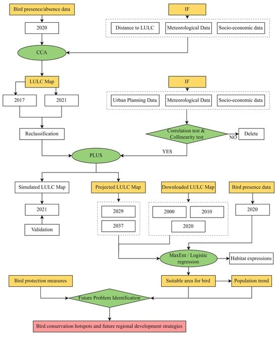
2. Materials and Methods
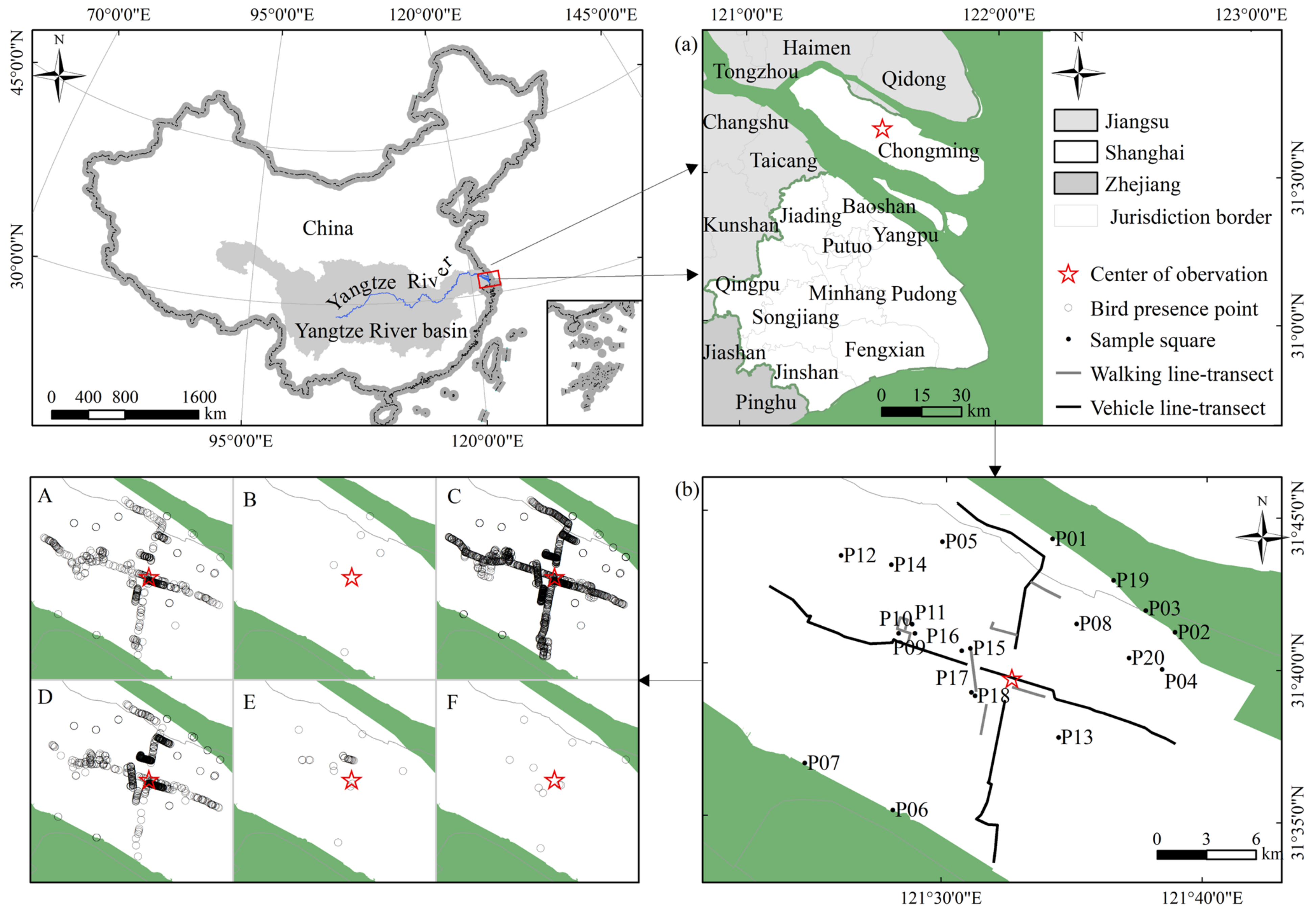
2.1. Study Site

The YRE, located where the Yangtze River meets the East China Sea, is home to the largest megacity in China, Shanghai (Figure 1). The study area encompasses the entire city of Shanghai, as well as parts of southeastern Jiangsu province and northeastern Zhejiang province, covering a total area of approximately 20,667 km2.
The YRE is located in the middle of the Asia–Pacific bird migration route, making it an important refuge for many endangered bird species [11]. One of the notable areas in the region is the Chongming Islands (Figure 1a), which is recognized as the largest alluvial island globally [23]. The island is home to diverse ecosystems, such as forests, agricultural lands, freshwater wetlands, and coastal salt marshes. It is estimated that around one million migratory waterbirds visit the coastal wetlands of Chongming every year [23,24]. Being an irreplaceable natural space in Shanghai in the 21st century [25], Chongming Island provides an excellent case study area to analyze the impacts of urbanization on bird habitats and explore sustainable development strategies for the YRE region [26].

2.2. Bird Survey

From June to August 2020, a fixed-date monthly survey was conducted over three consecutive days from 7:00 a.m. to 7:00 p.m. each day. The survey, centered on Dongping Forestry Park, employed a combined approach using sample sites, walking transects, and vehicle transects, with a total of 20, 6, and 4, respectively (Figure 1c). This approach was based on previous research [9] and considered landscape diversity [9] and target-point accessibility. Each walking sampling transect line was 2 km long and surveyed at a speed of 3–5 km/h. The vehicle sampling transect lines were 15 km long and surveyed at a speed of 30 km/h. Meanwhile, with the same investigators participating in surveys over the study period, surveys were conducted by two trained and experienced observers specifically skilled in bird surveys. In this way it is assumed that the observer effect on detectability is minimal. All 20 sampling sites, 6 walking transect lines, and 4 vehicle transect lines were sampled each month. A total of 3739 bird observation points were recorded using GPS, including 79 bird species, with a total of 11,696 birds (3724 bird-presence points and 15 bird-absence points) (Table 1).
Then bird presence data from 2000 to 2020 were also obtained from the Global Biodiversity Information Facility (GBIF) [27]. The Digital Object Identifier (DOI) of obtained online data is shown in the (Supplementary Table S1).
There are eight ecological groups of birds in the world, of which six ecological groups are distributed in China [28]. In this study all birds were classified into Terrestores, Raptatores, Passeres, Grallatores, Natatores, and Scansores, based on their lifestyle and traits (Figure 1A–F).

2.3. Datasets Used

The study utilized land use and land cover (LULC) data from two sources: Globe Land 30 from 2000 to 2010, obtained from the Ministry of Natural Resources of China [29], and Sentinel-2 from 2017 to 2021, obtained from ESRI [30]. Globe Land 30 had a spatial resolution of 30 m and were classified into 10 classes, with an overall accuracy of 83.5%, while Sentinel-2 LULC data had a spatial resolution of 10 m and were classified into 11 classes, with an overall accuracy of 85%. The study classified the LULC into six categories: farmland, wetland, urban green land, urban built-up, bare land, and water, with building sites and roads being identified as part of the urban built-up category.
Meteorological variables, including mean annual precipitation, surface temperature, surface soil moisture, wind speed, and wind direction, were obtained from the NASA Langley Research Center (LaRC) POWER Project, which was sponsored by the NASA Earth Science/Applied Science Program (https://power.larc.nasa.gov/ (accessed on 19 July 2021)). Meanwhile, socio-economic variables, including resident population, population density, gross domestic product, and gross product per capita, were obtained from the China Statistical Yearbook (http://www.stats.gov.cn/tjsj/ndsj./ (accessed on 20 July 2021)).
Finally, data on urban planning, such as urban boundaries, permanent conserved agricultural farmland, highways, main roads, residential areas, and water bodies, were obtained from the official document of the Shanghai Urban Master Plan (2017–2035) (https://www.shanghai.gov.cn/nw42806/index.html (accessed on 26 July 2021)).

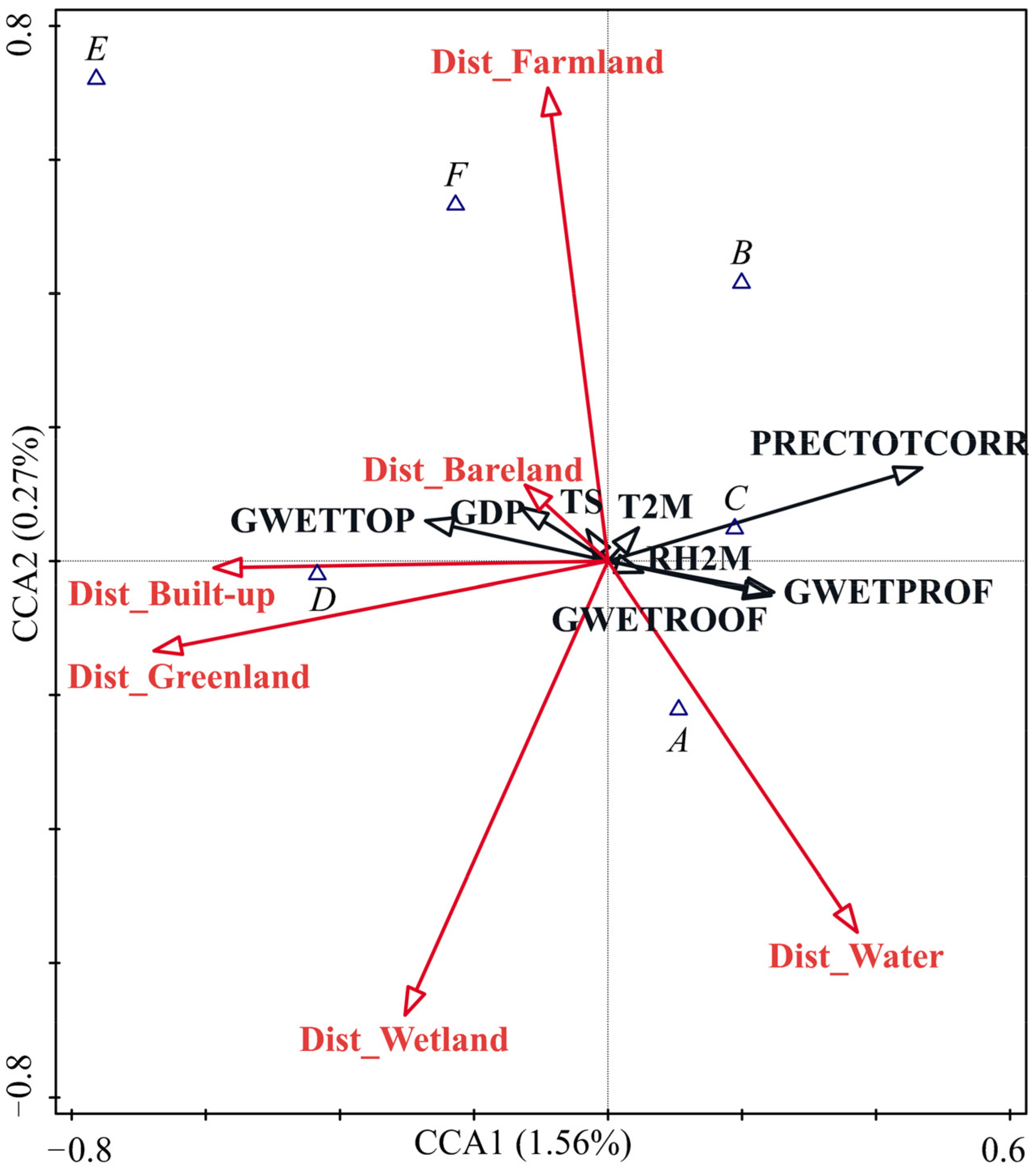
2.4. Selection of Variables by CCA to Quantify Birds’ Habitat

Variables of land use, meteorology and socio-economy were often used to simulate bird habitat [31]. In this study, through ordination analysis using Canonical Correlation Analysis (CCA) of Conoco5, variables with significant effects on birds were identified. Variables with significant effects were used as environmental variables for simulating and predicting the distribution of birds in the Yangtze River estuary.

2.5. LULC Projection and Validation

Meteorological, socio-economic, and policy factors, as well as available LULC data, are commonly used to simulate land use scenarios [32]. However, multicollinearity between environmental factors can often lead to overfitting in models [33]. To address this issue, screening requirements were implemented, including Pearson’s correlation coefficient < 0.75 [34] and variance inflation factor (VIF) values < 10 (Supplementary Table S2) [35]. Following screening, eight independent variables were selected: precipitation, population density, GDP per capita, distance to residential area, distance to water, distance to stream, distance to highway (road with an assigned speed > 60 km/h), and distance to main road (road with an assigned speed < 40–60 km/h).
In recent years, the patch-generating land use simulation (PLUS) model has been widely used for planning and policymaking [32,36]. In this study, the PLUS model was used to predict the future LULC of the study region. The expansion of each land use type was first sampled by comparing two periods of LULC; then, the driving forces of each land use expansion were calculated using a random forest algorithm. Lastly, the development probability of land use and the contribution of eight environmental factors were obtained [32]. Under the constraint of development probability, the computation process combined stochastic seed generation with a threshold-decreasing mechanism to generate dynamic simulation patches [32]. Landscape metrics, including the number of patches (NP) and landscape shape index (LSI) by Fragstats4.2, were computed to analyze the landscape patterns.
The kappa index was used to test the acceptance of the LULC simulation. If kappa > 0.6, the simulation is accepted [37]. However, after pre-simulation, the deviation between the simulated LULC scenarios by GlobeLand30 data and the actual LULC was large, especially in the coastal reclamation area. Since 2013, large coastal reclamation projects have been strictly prohibited by the Chinese government for ecosystem integrity maintenance [38,39]. Furthermore, the higher the spatial resolution of the data, the lower the deviation [21]. Considering these conditions, this study simulated future LULC scenarios using high-resolution Sentinel-2 Land Use/Land Cover data (2017, 2021). The years 2029 and 2037 were chosen for prediction in order to be consistent with the planning period of Shanghai (https://www.shanghai.gov.cn/nw42806/index.html (accessed on 26 July 2021)) and the requirement of the PLUS model, i.e., time intervals of 4 years [32].

2.6. Quantifying Birds’ Habitats Using MaxEnt

The MaxEnt model has been shown to be effective in projecting species distributions using presence-only data [17]. In this study, MaxEnt version 3.4.4 was used to assess the impact of environmental variables on bird habitat distribution [40]. In MaxEnt, species distribution patterns and environmental variables must have the same spatial resolution [35]. The ENM tool can automatically match the resolution of the raster environmental variables and remove redundant data without accidentally deleting important information [41]. In this study, the species distribution data were screened using the “trimdupes.by.raster” function of the ENM Tools package (version 1.0.6) in R (version 4.1.3) [42]. A total of 2460 species distribution data points were selected for the analysis (see Table 1).
Based on the assumption of smoothed species niches [43], the variables obtained using MaxEnt were used to simulate and predict the potentially suitable areas for birds. The results were presented as probability distribution maps. We then used the Jenks natural break classification method [18,44] and the number of birds within each survival probability interval to identify the tipping point and categorize areas as suitable or non-suitable. By overlaying the suitable habitat of each ecological group with equal weights, we obtained the overlay grade of bird habitats in the YRE for 2000, 2010, 2020, 2029, and 2037, and the bird population trend.
Next, we used logistic regression analysis with the significant variables to obtain the ecological habitat equation for different bird groups and for all birds. To validate the logistic regression models, we used the Omnibus test (with a significance threshold of <0.05) to determine the overall significance of the models, the Hosmer–Lemeshow test (with a significance threshold of >0.05) to assess the goodness of fit, and the regression coefficient hypothesis test (with a significance threshold of <0.05) to determine the statistical significance of individual variables [45].

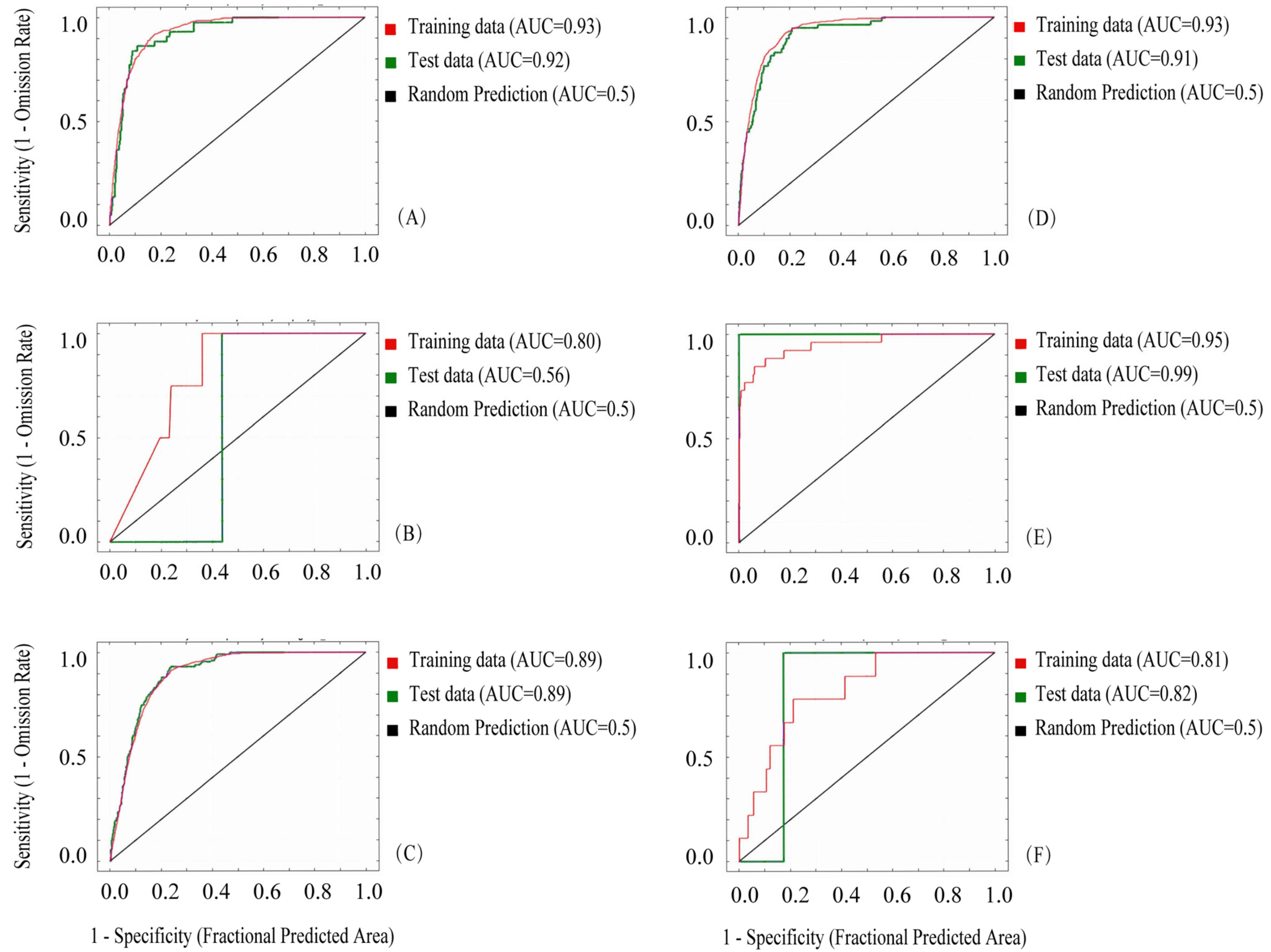
2.7. Habitat Model Validation

Among the bird occurrence sites, 75% were used as training data, and the remaining 25% were used for validation. The area under the receiver operating characteristic curve (AUC) was used to assess the model’s accuracy. An AUC value greater than 0.7 indicated an acceptable model with a suitable ecological niche [46]. Furthermore, the globally shared bird presence data from GBIF were overlaid with the predicted suitable zones, to validate the model. The percentage contribution (Table 2) was used to evaluate the significance of variables on bird presence, and the response curves were used to demonstrate how the predicted probability of presence changed as each variable varied while keeping other environmental variables at their average sample value. Logistic regression analysis was employed to determine the linear relationship between bird habitat and significant effects.

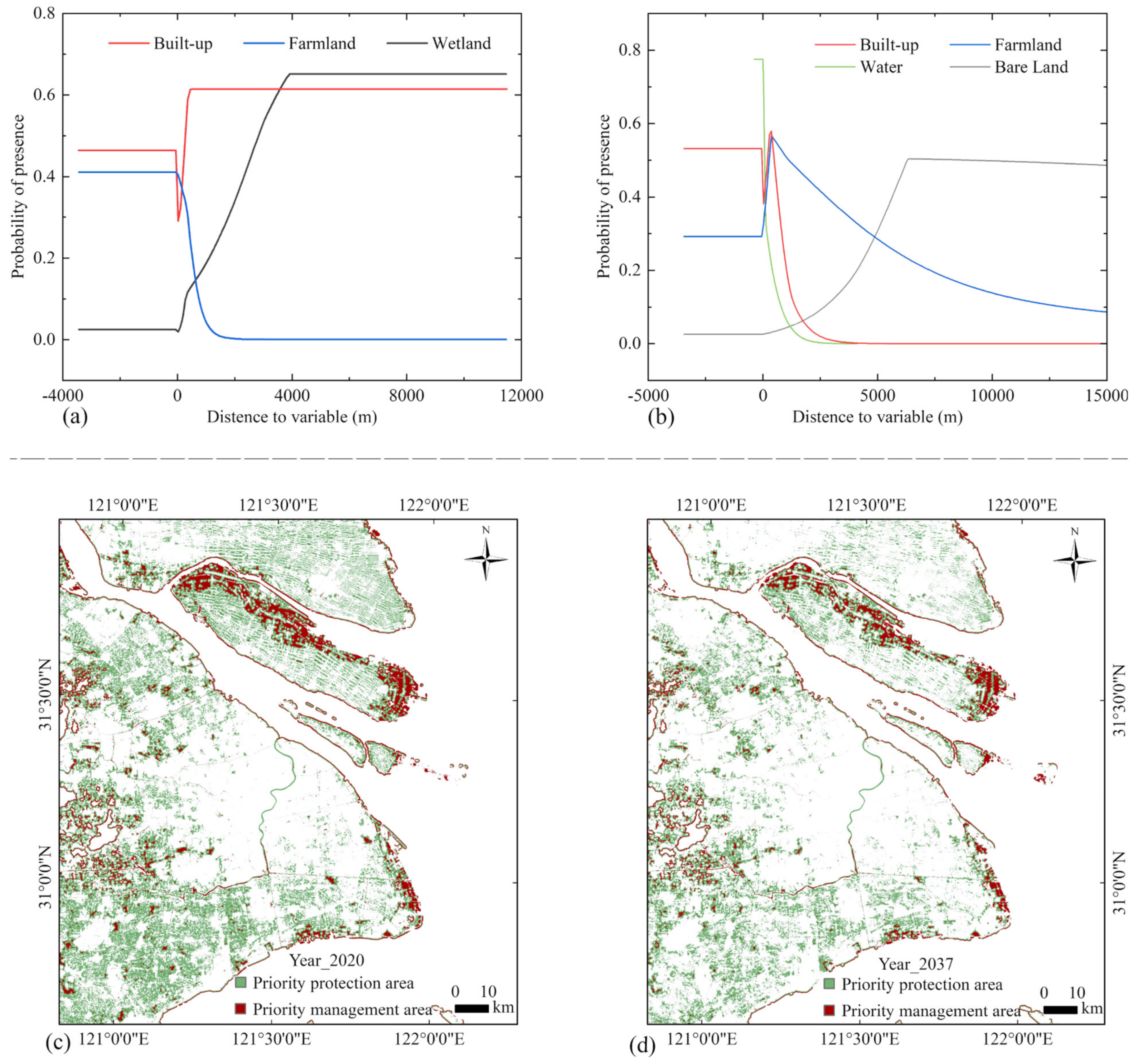
2.8. Delineation of Priority Protected Area and Priority Management Area

Based on the contribution value and response curves in the MaxEnt model, as well as the critical variables identified in the logistic management analysis, priority management areas were delineated. These priority management areas were merged with other suitable habitats to obtain priority protection areas for birds. Finally, these priority protection and management areas were compared with the ecological protection areas designated in the Shanghai Urban Master Plan (2017–2035) (see Supplementary Figure S3). Management gaps for future bird protection were analyzed and land use regulation policies were presented.
The overall methodology is summarized in a flowchart shown in Figure 2.

3. Results

3.1. Factors Affecting Bird Habitats

The results of the ordination analysis showed that the distance to each type of land use significantly impacted bird survival in the YRE, with a cumulative contribution of over 90% at a 99% confidence level (Figure 3, Supplementary Table S3). Terrestrials’ existence is positively correlated with the distance from water; Raptatores and Grallatores’ existence is positively correlated with the distance from farmland; Passeres’ existence is negatively correlated with the distance from urban green land; Natatores’ existence is positively correlated with the distance from bare land; and Scansorials’ existence is strongly negatively correlated with the distance from water.

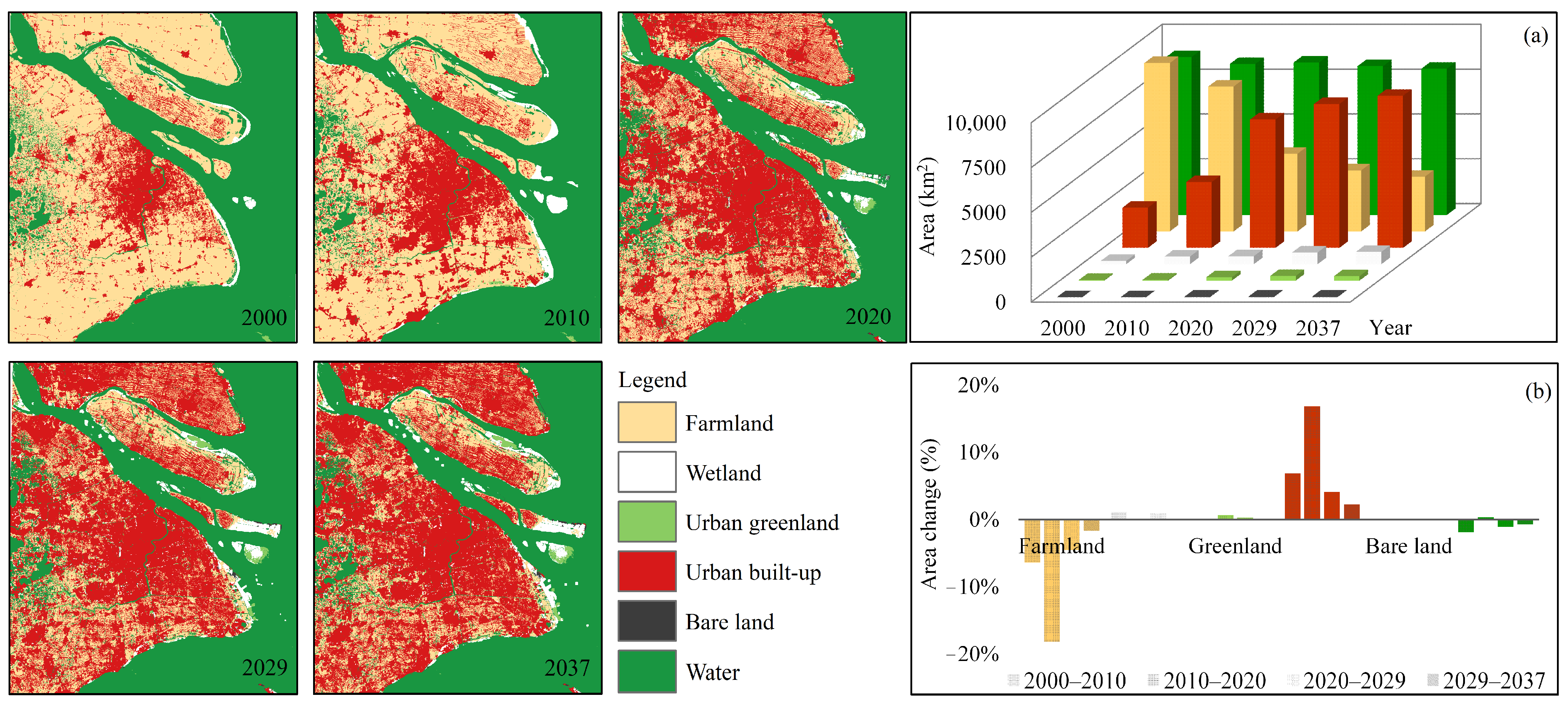
3.2. LULC Simulation and Evaluation

The simulated 2021 LULC was validated using actual 2021 LULC interpreted by Sentinel-2 satellite images, as shown in Supplementary Figure S1c. The simulation was found to be highly accurate, with an overall accuracy of 90.65% and a kappa index of 0.86. However, it should be noted that the simulation of coastal wetlands was not accurate, due to the influence of tides [47]. Overall, except for parts of the coastal wetlands, the simulated LULC was deemed acceptable when compared to the 2021 Google map (Supplementary Figure S1a,b).

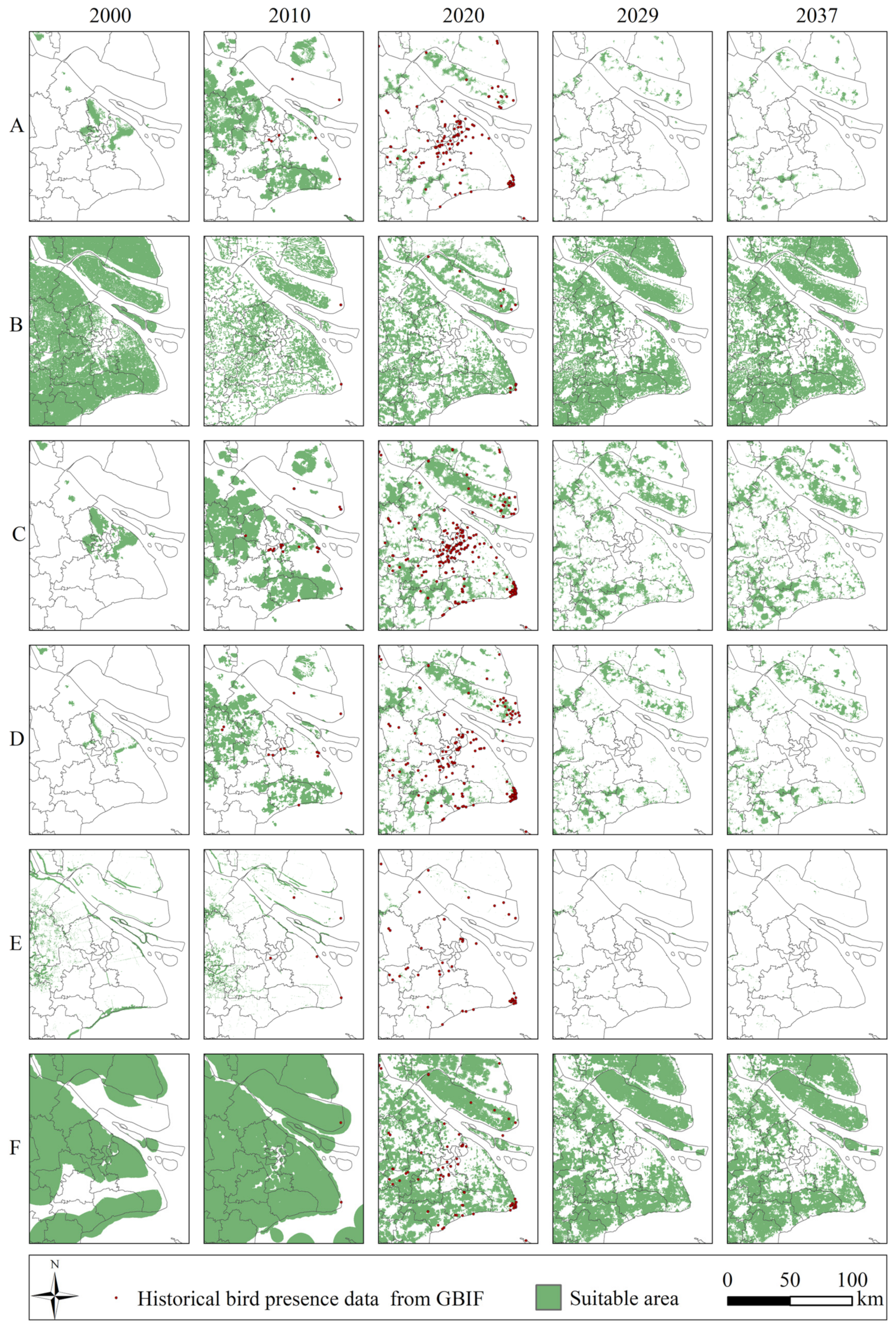
3.3. LULC Spatiotemporal Dynamics

The dominant land-use and land-cover categories in the Yangtze estuary region were urban built-up, farmland, and water (Figure 4). Over the period of 2000 to 2037, the region underwent significant fragmentation and complexity at both the landscape (Supplementary Table S4) and class levels (Supplementary Table S5), particularly in urban built-up and farmland. From 2000 to 2037, the total area of farmland and water decreased by 6333 km2 and 654 km2, respectively, while the total area of urban built-up, wetland, urban green land, and bare land increased by 6243 km2, 505 km2, 212 km2, and 27 km2, respectively (Figure 4a).
The changes in LULC were not consistent from 2000 to 2037 (Figure 4a), exhibiting a pattern of rapid to slow changes (Figure 4b). Between 2000 and 2010, farmland and water bodies decreased by 6.34% and 1.85%, respectively, while urban built-up, wetland, urban green land, and bare land increased by 6.94%, 1.2%, 0.64%, and 0.13%, respectively. The changes in LULC were mainly driven by urbanization, including the occupation of farmland or reclamation of coastal areas for urban development. Between 2010 and 2020, the area of farmland decreased by 18.16%, while the urban built-up area increased by 16.85%, indicating a more rapid urban development than the previous decade. The trends between 2020 and 2029 and between 2029 and 2037 were similar to the previous periods, but with a flattened trend. Despite the policy of basic farmland protection, conservation farmland changed little, with a change of only 4.46% and 1.67% in the two periods, respectively. The area of urbanization continued to increase, but at a slower rate of 4.15% and 2.26% from 2020 to 2029 and 2029 to 2037, respectively.

3.4. Habitat Simulation and Validation

The AUC values for all six ecological groups of birds exceeded 0.8, with Terrestores, Grallatores, and Natatores having values above 0.9 (Figure 5). The MaxEnt model was reliable in assessing the suitability of each ecological group’s habitat [46]. The threshold for the suitable zone of Terrestores, Raptatores, Passeres, Grallatores, Natatores, and Scansores was 0.5, 0.5, 0.3, 0.5, 0.6, and 0.3, respectively. In 2010 and 2020, 46.8% and 48.4% of the suitable areas were confirmed by GBIF bird presence data, respectively (Figure 6).
Except for Natatores, Omnibus test significance values were lower than 0.05 and Hosmer–Lemeshow test significance values were higher than 0.05 for all five groups and the overall bird model (Table 3). All six logistic regression models were significant and well fitted. The failure of the Natatores model estimation was due to the habitat’s small size and the ineffective random sampling of points in the suitable area.

3.5. Birds’ Habitats Spatiotemporal Pattern

In 2000, Terrestores, Passeres, and Grallatores were mainly distributed in the ecotone between urban built-up and farmland (Figure 6). As urbanization developed, farmlands were overtaken by urban areas, and the ecotone expanded outward from the urban center. By 2000, the main habitats of these three ecological groups were in the near suburban area, but by 2020 the habitats were scattered in the far suburban area. From 2000 to 2037, suitable habitat areas first increased, then decreased, and eventually flattened (Figure 7).
Natatores are water birds that prefer aquatic habitats. In 2000, they were mainly distributed in Taihu Lake and coastal areas. However, the total area of Natatores’ habitat decreased by about 199 km2 from 2000 to 2010 and then decreased more rapidly, by about 816 km2, after 2010 (Figure 7). Raptors and Scansores have a wide range of habitat preferences for their behavior (Chace and Walsh, 2006), and after 2010 they were mainly distributed in non-urbanized areas. The suitable habitat for Raptatores decreased quickly by 6093 km2 and then slowly increased, while that for Scansores first increased by 4622 km2 and then decreased (Figure 7).
The accumulation analysis of bird habitats can reflect the general habitat dynamics in YRE. Level 0 indicates a non-bird habitat, while Level 1 indicates a bird habitat suitable for an ecological group. The higher the level, the more overlapping the habitat of different ecological groups. The proportion of suitable areas (Supplementary Figure S2) was 66.06%, 74.75%, 41.39%, 46.09%, and 45.22% in the years 2000, 2010, 2020, 2029, and 2037, respectively. In 2000, the suitable zones were mainly at Level 3 (36.15%) and Level 2 (16.28%) of the classes (Supplementary Figure S2b). In 2010, the main habitat classes were Level 1 (36.25%) and Level 2 (18.27%). After 2010, the class of Level 0 became the main habitat class, with a proportion of more than 50%, indicating habitat degradation. The percentage of suitable habitat dynamics was +8.69% from 2000 to 2010, −33.36% from 2010 to 2020, and +4% from 2020 to 2037.

3.6. Priority Protected Areas and Management Areas

The suitable habitats tended to overlap spatially (Supplementary Figure S2b). The suitability of habitat for the five ecological groups was negatively correlated with the distance to farmland. In other words, the farther the distance to farmland, the less favorable it was for their survival. From the perspective of overall bird survival, distance to farmland and green land had a general effect and were negatively correlated, with the coefficient of distance to farmland being about 17 times that of distance to green land (Table 3).
From the perspective of bird species conservation, the habitat for the Terrestores and Natatores groups almost disappeared after the year 2029 (Figure 6). The distance to farmland and the distance to wetland were the two most important factors in interpreting the habitat of Terrestores (Table 2). Combining the response curves of important variables and the distance to built-up areas, we found that (1) Terrestores preferred habitats inland and away from the sea, and their habitat suitability increased with distance from wetlands (Figure 8a); (2) Habitat suitability of the 300 m buffer from the built-up areas was lower than both the built-up areas and suburban areas beyond the 300 m buffer (Figure 8a). Terrestores in the built-up areas have access to human-provided food in addition to autonomous foraging in the human-made environment [48], while in the suburban area they can forage independently in the natural environment. However, the high disturbance of these environments also brings challenges for Terrestores [48]; (3) The habitat suitability of Terrestores declined with increasing distance from farmland (Figure 8a). Terrestores were mainly distributed in the farmland around the built-up areas (Figure 4 and Figure 6). In the areas of farmlands beyond the 300 m buffer of built-up areas, human disturbance is lower and more suitable for birds.
Similarly, the distance to farmland, the distance to water, and the distance to bare land were the three main factors in interpreting the habitat of Natatores (Table 2). Natatores preferred the habitat of water and farther distance from bare land (Figure 8b). The area with water and which was 200–400 m from farmland was the most suitable area for Natatores (Figure 8b). This is attributed to the trait of Natatores always nesting and breeding near the shore. Additionally, the water area which was 300–500 m from the built-up area was another suitable area for Natatores.
The identified priority protection areas were concentrated in Chongming, Pudong, Jinshan, Fengxian, and Taihu Lake area, while the priority management areas were concentrated in Chongming, Lingang, Jinshan, Taihu Lake, and the coastal area of the YRE (Figure 8c,d).

4. Discussion

4.1. Bird Habitat Quantification and Spatiotemporal Dynamics

The area of bird habitat for each ecological group changed dramatically around 2010, initially increasing before 2010 and then decreasing rapidly after 2010, overall. This change was closely related to the land development and reclamation processes during these two decades [38,39]. Our results align with previous researchers’ bird habitat studies, showing that birds exhibit flexible responses to the increasing intensity of urbanization [10]. In the initial stage of urbanization, increased primary productivity due to human disturbance enhanced habitat quality by providing food and shelter [1]. During this phase, bird abundance was positively correlated with land use change. From 2000 to 2010, the percentage of suitable bird habitat area increased by 8.69% (Supplementary Figure S2b). As reported by Tews et al. (2004), this increase in habitat supported a high level of species diversity, and habitats evolved towards accommodating a greater number of bird taxa, consistent with the response of bird habitats to urbanization development [12].
As urbanization continued and intensified, vegetation cover was significantly altered or reduced, leading to the disturbance or removal of native vegetation and habitat fragmentation (Supplementary Figure S2), resulting in degraded bird-habitat quality [9,13,14]. The percentage of suitable habitat area decreased by 33.36% from 2010 to 2020. The reduction in the proportion of total habitat after 2010 is about four times the previous increase before 2010. This is consistent with the findings of previous researchers regarding changes in bird populations under increasing urbanization intensity [1,14]. During this time, bird abundance was negatively correlated with land use change [14]. Therefore, the trend of first increasing and then decreasing reveals that the intensity of urbanization between 2010 and 2020 exceeded the threshold of bird adaptivity, and the study area has passed the bilateral stage of simultaneous urban development and increasing bird richness [18].
The habitats of various ecological groups in YRE increasingly overlapped from 2000 to 2037. As reported by Chen et al. (2019), birds of different ecological groups tend to coexist in the same habitat, intensifying interspecific interactions or competition. Moreover, the habitat became fragmented, and the percentage of suitable habitat area decreased by 21% from 2000 to 2037, resulting in a loss of approximately 4340 km2. Therefore, establishing a connected spatial network of habitat hotspots is essential for maintaining bird populations in the area.

4.2. Future Regional Development Strategies and Bird Conservation Measures

From the perspective of bird species conservation, most of the habitats showed a slight decrease and remained stable after 2029. While birds of the Scansores group seemed to have a relatively promising future, the habitat for the Terrestores and Natatores groups almost disappeared after 2029. The management of the Terrestores’ and Natatores’ habitats should be prioritized in the future. Farmland outside the built-up area was the preferred habitat for Terrestores, but their survival probability was reduced in areas within 300 m from the edge of the built-up area. Aouissi et al. (2021) discovered that increasing green-space diversity can increase biodiversity. Therefore, establishing new green spaces as avian ecological corridors in the vicinity of suburban areas is necessary for Terrestores’ habitat maintenance [16]. Water was the preferred habitat of Natatores, and they preferred water close to agricultural land compared to water near built-up areas. Optimizing the area of the water and farmland ecotone can help protect Natatores. In the future, more attention should be paid to areas within the 300 m buffer from the coast for Natatores.
Compared to the ecological protection areas designated by the Shanghai Urban Master Plan (2017–2035) (Supplementary Figure S3), most of the priority protection and management areas identified in our study will not receive the same level of attention as the first- and second-class ecological conservation areas. Although the identified priority areas fall within the third-class ecological conservation area, the loosely defined management requirements of the third-class conservation areas may make these priority areas susceptible to human impacts in the future. Therefore, these areas should be closely monitored to ensure their effective conservation in the future.
It is essential to develop specific strategies for managing the priority ecological areas, especially concerning land development within bird priority management areas. By prioritizing the protection of ecologically sensitive bird habitats and taking regional coordination into account [2], we recommend not only conserving the current national nature reserve areas, but also giving priority to the conservation and management of areas in Chongming, Pudong, and Taihu Lake. In Chongming, which is ecologically diverse and suitable for birds, maintaining the current land use status quo or expanding the coverage area of farmland and green spaces is the preferred option for achieving ecological sustainability. It is necessary to reduce or even avoid further fragmentation of the land in the future. In other areas suitable for birds but prone to fragmentation, ecological sustainability can be achieved by increasing farmland or green spaces, to build or expand ecological corridors. Furthermore, Josefsson et al. (2017) reported that crop structural diversity (such as autumn-sown cereals, spring-sown cereals, etc.) positively affected bird richness compared with forest-dominated landscapes. Thus, increasing crop structural diversity and crop diversity are critical to maintain bird populations in YRE.

5. Conclusions

We obtained the following conclusions.
(1)
Land use and land cover of urban built-up and farmland are important factors affecting bird habitats, with farmland areas positively correlated with bird habitat. The rapid expansion of urbanization is the primary driver of changes in bird habitats. The 300 m buffer zone around urban built-up areas is critical for maintaining bird habitats.
(2)
The habitats of different ecological groups of birds in the Yangtze River Estuary are increasingly overlapping and shrinking, leading to increased competition between species.
(3)
Habitat management efforts should prioritize addressing the impacts of urban expansion on bird habitats, conserving hotspot areas, and managing ecotones associated with farmland.

Supplementary Materials

The following supporting information can be downloaded at: https://www.mdpi.com/article/10.3390/land12122115/s1, Table S1: The Digital Object Identifier (DOI) of various bird species in Global Biodiversity Information Facility (GBIF). Table S2: The related parameters of PLUS model. The Pearson product-moment correlation coefficient and VIF of environmental variables. Table S3: The explanation, contribution and p value of the important environmental data in ordination biplots. Table S4: Landscape pattern index of LULC landscape level in Yangtze estuary. Table S5: Landscape pattern index of LULC class level in Yangtze estuary. Figure S1: Simulated LULC 2021. The simulated LULC in 2021 (a (1–4)) was compared with the 2021 Google map (b (1–4)). (c) The simulated 2021 LULC, generated based on the actual LULC of 2017 and 2021, was validated with the actual 2021 LULC interpreted by Sentinel-2 satellite images. Figure S2: The level of bird habitats from 2000–2037. Level 0 indicated a non-bird habitat. Level 1 indicated a bird habitat suitable for an ecological group. The higher the level represented, the more overlapping the habitat of different ecological groups. (a) The per Area changes (%) of suitable bird habitat and each LULC type in the four periods (2000–2010, 2010–2020, 2020–2029, and 2029–2037). (b) Change in the proportion of area to total area from 2000 to 2037. Figure S3: Shanghai Ecological Spatial Planning Map. Ecology_1 refers to the first-class ecological space, which includes the core areas of Chongming Dongtan Bird National Nature Reserve and Jiuduansha Wetland National Nature Reserve. Ecology_2 refers to the second-class ecological space, which includes the edge areas of national-level nature reserves, natural reserves located within cities, primary protected areas of drinking-water sources, core areas of forest parks, core areas of geoparks, mountains, and important wetlands. Ecology_3 refers to the third-class ecological space, which includes permanent basic farmland, forest land, wetlands, rivers, lakes, wildlife habitats, and other ecological protection areas. Finally, Ecology_4 refers to the fourth-class ecological space, which includes the outer-ring green belt, urban-park green space, water systems, wedge-shaped green spaces, and more.

Author Contributions

M.G.—Software, validation, writing—original draft, visualization. S.F.—Conceptualization, investigation, supervision. Y.H.—Investigation, data curation. D.Z.—Investigation. Z.W.—Investigation. P.H.—Original draft. Y.P.—Investigation. M.J.D.—Original draft. T.G.G.—Original draft. All authors have read and agreed to the published version of the manuscript.

Funding

This work is sponsored by the National Key R&D Program of China (2017YFC0506002), the Natural Science Foundation of China (31872695), with funding from the Oceanography Administration of Shanghai (HHK-2022-03).

Data Availability Statement

Data available on request from the authors.

Conflicts of Interest

The authors declare no conflict of interest.

References

  1. Pal, M.; Pop, P.; Mahapatra, A.; Bhagat, R.; Hore, U. Diversity and Structure of Bird Assemblages Along Urban-Rural Gradient in Kolkata, India. Urban For. Urban Green. 2019, 38, 84–96. [Google Scholar] [CrossRef]
  2. Sun, B.; Lu, Y.L.; Yang, Y.F.; Yu, M.Z.; Yuan, J.J.; Yu, R.; Bullock, J.M.; Stenseth, N.C.; Li, X.; Cao, Z.W.; et al. Urbanization Affects Spatial Variation and Species Similarity of Bird Diversity Distribution. Sci. Adv. 2022, 8, 9. [Google Scholar] [CrossRef]
  3. Almond, R.E.; Grooten, M.; Peterson, T. Living Planet Report 2020-Bending the Curve of Biodiversity Loss; World Wildlife Fund: Washington, DC, USA, 2020. [Google Scholar]
  4. Grimm, N.B.; Faeth, S.H.; Golubiewski, N.E.; Redman, C.L.; Wu, J.G.; Bai, X.M.; Briggs, J.M. Global Change and the Ecology of Cities. Science 2008, 319, 756–760. [Google Scholar] [CrossRef] [PubMed]
  5. Abbitt, R.J.F.; Scott, J.M.; Wilcove, D.S. The Geography of Vulnerability: Incorporating Species Geography and Human Development Patterns into Conservation Planning. Biol. Conserv. 2000, 96, 169–175. [Google Scholar] [CrossRef]
  6. Powers, R.P.; Jetz, W. Global Habitat Loss and Extinction Risk of Terrestrial Vertebrates under Future Land-Use-Change Scenarios. Nat. Clim. Chang. 2019, 9, 323–329. [Google Scholar] [CrossRef]
  7. Luck, G.W.; Ricketts, T.H.; Daily, G.C.; Imhoff, M. Alleviating Spatial Conflict between People and Biodiversity. Proc. Natl. Acad. Sci. USA 2004, 101, 182–186. [Google Scholar] [CrossRef] [PubMed]
  8. Zhang, L.; Wu, B.F.; Yin, K.; Li, X.S.; Kia, K.; Zhu, L. Impacts of Human Activities on the Evolution of Estuarine Wetland in the Yangtze Delta from 2000 to 2010. Environ. Earth Sci. 2015, 73, 435–447. [Google Scholar] [CrossRef]
  9. Jung, M.; Scharlemann, J.P.W.; Rowhani, P. Landscape-Wide Changes in Land Use and Land Cover Correlate with, but Rarely Explain Local Biodiversity Change. Landsc. Ecol. 2020, 35, 2255–2273. [Google Scholar]
  10. Francois, C.; Alexandre, L.; Julliard, R. Effects of Landscape Urbanization on Magpie Occupancy Dynamics in France. Landsc. Ecol. 2008, 23, 527–538. [Google Scholar] [CrossRef]
  11. Xu, X.; Xie, Y.J.; Qi, K.; Luo, Z.K.; Wang, X.R. Detecting the Response of Bird Communities and Biodiversity to Habitat Loss and Fragmentation Due to Urbanization. Sci. Total Environ. 2018, 624, 1561–1576. [Google Scholar] [CrossRef]
  12. Seaborn, T.; Goldberg, C.S.; Crespi, E.J. Drivers of Distributions and Niches of North American Cold-Adapted Amphibians: Evaluating Both Climate and Land Use. Ecol. Appl. 2021, 31, 15. [Google Scholar] [CrossRef] [PubMed]
  13. Chace, J.F.; Walsh, J.J. Urban Effects on Native Avifauna: A Review. Landsc. Urban Plan. 2006, 74, 46–69. [Google Scholar] [CrossRef]
  14. Rosenberg, K.V.; Dokter, A.M.; Blancher, P.J.; Sauer, J.R.; Smith, A.C.; Smith, P.A.; Stanton, J.C.; Panjabi, A.; Helft, L.; Parr, M.; et al. Decline of the North American Avifauna. Science 2019, 366, 120–124. [Google Scholar] [CrossRef] [PubMed]
  15. Jose, S.; Nameer, P.O. The Expanding Distribution of the Indian Peafowl (Pavo Cristatus) as an Indicator of Changing Climate in Kerala, Southern India: A Modelling Study Using Maxent. Ecol. Indic. 2020, 110, 105930. [Google Scholar] [CrossRef]
  16. Aouissi, H.A.; Petrisor, A.I.; Ababsa, M.; Bostenaru-Dan, M.; Tourki, M.; Bouslama, Z. Influence of Land Use on Avian Diversity in North African Urban Environments. Land 2021, 10, 434. [Google Scholar] [CrossRef]
  17. Sohl, T.L. The Relative Impacts of Climate and Land-Use Change on Conterminous United States Bird Species from 2001 to 2075. PLoS ONE 2014, 9, 18. [Google Scholar] [CrossRef]
  18. Kong, X.S.; Zhou, Z.Z.; Jiao, L.M. Hotspots of Land-Use Change in Global Biodiversity Hotspots. Resour. Conserv. Recycl. 2021, 174, 10. [Google Scholar] [CrossRef]
  19. Saunders, S.P.; Meehan, T.D.; Michel, N.L.; Bateman, B.L.; DeLuca, W.; Deppe, J.L.; Grand, J.; LeBaron, G.S.; Taylor, L.; Westerkam, H.; et al. Unraveling a Century of Global Change Impacts on Winter Bird Distributions in the Eastern United States. Glob. Change Biol. 2022, 28, 2221–2235. [Google Scholar] [CrossRef]
  20. Scharlemann, J.P.W.; Green, R.E.; Balmford, A. Land-Use Trends in Endemic Bird Areas: Global Expansion of Agriculture in Areas of High Conservation Value. Glob. Change Biol. 2004, 10, 2046–2051. [Google Scholar] [CrossRef]
  21. Li, X.; Chen, G.Z.; Liu, X.P.; Liang, X.; Wang, S.J.; Chen, Y.M.; Pei, F.S.; Xu, X.C. A New Global Land-Use and Land-Cover Change Product at a 1-Km Resolution for 2010 to 2100 Based on Human-Environment Interactions. Ann. Am. Assoc. Geogr. 2017, 107, 1040–1059. [Google Scholar] [CrossRef]
  22. Wang, G.; Wang, C.; Guo, Z.R.; Dai, L.J.; Wu, Y.Q.; Liu, H.Y.; Li, Y.F.; Chen, H.; Zhang, Y.N.; Zhao, Y.X.; et al. Integrating Maxent Model and Landscape Ecology Theory for Studying Spatiotemporal Dynamics of Habitat: Suggestions for Conservation of Endangered Red -Crowned Crane. Ecol. Indic. 2020, 116, 106472. [Google Scholar] [CrossRef]
  23. Li, B.; Yuan, X.; Chen, M.; Bo, S.Q.; Xia, L.; Guo, Y.; Zhao, S.S.; Ma, Z.J.; Wang, T.H. How to Strive for Balance of Coastal Wind Energy Development with Waterbird Conservation in the Important Coastal Wetlands, a Case Study in the Chongming Islands of East China. J. Clean. Prod. 2020, 263, 121547. [Google Scholar] [CrossRef]
  24. Cai, W.Q.; Song, X.M.; Zhang, P.F.; Xin, Z.C.; Zhou, Y.; Wang, Y.T.; Wei, W.D. Carbon Emissions and Driving Forces of an Island Economy: A Case Study of Chongming Island, China. J. Clean. Prod. 2020, 254, 120028. [Google Scholar] [CrossRef]
  25. Li, H.; Cai, Y.L. Regional Eco-Security Assessment Based on the Perspective of Complex System Science: A Case Study of Chongming in China. Hum. Ecol. Risk Assess. 2011, 17, 1210–1228. [Google Scholar] [CrossRef]
  26. Zhan, J.Y.; Zhang, F.; Chu, X.; Liu, W.; Zhang, Y. Ecosystem Services Assessment Based on Emergy Accounting in Chongming Island, Eastern China. Ecol. Indic. 2019, 105, 464–473. [Google Scholar] [CrossRef]
  27. User, G. BIF.Org. Occurrence Download; The Global Biodiversity Information Facility: Copenhagen, Denmark, 2022. [Google Scholar]
  28. Wu, Q.M.; Ma, J.Z.; Zou, H.F. Correlation between the Avian Community and Habitat Type During the Wintering Period in Zhalong National Nature Reserve, China. Adv. Mater. Res. 2013, 779, 1634–1638. [Google Scholar] [CrossRef]
  29. Jun, C.; Ban, Y.; Li, S. Open Access to Earth Land-Cover Map. Nature 2014, 514, 434. [Google Scholar] [CrossRef] [PubMed]
  30. Karra, K.; Kontgis, C.; Statman-Weil, Z.; Mazzariello, J.C.; Mathis, M.; Brumby, S.P. Global Land Use/Land Cover with Sentinel 2 and Deep Learning. In Proceedings of the 2021 IEEE International Geoscience and Remote Sensing Symposium IGARSS, Brussels, Belgium, 11–16 July 2021. [Google Scholar]
  31. Montenegro, C.; Solitario, L.A.; Manglar, S.F.; Guinto, D.D. Niche Modelling of Endangered Philippine Birds Using Garp and Maxent. In Proceedings of the 7th International Conference on Cloud Computing, Data Science and Engineering (Confluence 2017), Noida, India, 12–13 January 2017; pp. 547–551. [Google Scholar]
  32. Liang, X.; Guan, Q.F.; Clarke, K.C.; Liu, S.S.; Wang, B.Y.; Yao, Y. Understanding the Drivers of Sustainable Land Expansion Using a Patch-Generating Land Use Simulation (Plus) Model: A Case Study in Wuhan, China. Comput. Environ. Urban Syst. 2021, 85, 101569. [Google Scholar] [CrossRef]
  33. Hending, D. Niche-Separation and Conservation Biogeography of Madagascar’s Fork-Marked Lemurs (Cheirogaleidae: Phaner): Evidence of a New Cryptic Species? Glob. Ecol. Conserv. 2021, 29, 17. [Google Scholar] [CrossRef]
  34. Kalboussi, M.; Achour, H. Modelling the Spatial Distribution of Snake Species in Northwestern Tunisia Using Maximum Entropy (Maxent) and Geographic Information System (Gis). J. For. Res. 2018, 29, 233–245. [Google Scholar] [CrossRef]
  35. Sillero, N.; Barbosa, A.M. Common Mistakes in Ecological Niche Models. Int. J. Geogr. Inf. Sci. 2021, 35, 213–226. [Google Scholar] [CrossRef]
  36. Xu, L.F.; Liu, X.; Tong, D.; Liu, Z.X.; Yin, L.R.; Zheng, W.F. Forecasting Urban Land Use Change Based on Cellular Automata and the Plus Model. Land 2022, 11, 652. [Google Scholar] [CrossRef]
  37. Alam, N.; Saha, S.; Gupta, S.; Chakraborty, S. Prediction Modelling of Riverine Landscape Dynamics in the Context of Sustainable Management of Floodplain: A Geospatial Approach. Ann. GIS 2021, 27, 299–314. [Google Scholar] [CrossRef]
  38. Jiang, S.; Xu, N.; Li, Z.C.; Huang, C.H. Satellite Derived Coastal Reclamation Expansion in China since the 21st Century. Glob. Ecol. Conserv. 2021, 30, e01797. [Google Scholar] [CrossRef]
  39. Miao, D.D.; Xue, Z.H. The Current Developments and Impact of Land Reclamation Control in China. Mar. Policy 2021, 134, 104782. [Google Scholar] [CrossRef]
  40. Phillips, S.J.; Anderson, R.P.; Schapire, R.E. Maximum Entropy Modeling of Species Geographic Distributions. Ecol. Model. 2006, 190, 231–259. [Google Scholar] [CrossRef]
  41. Warren, D.; Dinnage, R.; Matzke, N.J.; Huron, N.; Baumgartner, J. Danlwarren/Enmtools: Enmtools, Version 1.0.4; Zenodo: online, 2021. [CrossRef]
  42. Muscarella, R.; Galante, P.J.; Soley-Guardia, M.; Boria, R.A.; Kass, J.M.; Uriarte, M.; Anderson, R.P. Enmeval: An R Package for Conducting Spatially Independent Evaluations and Estimating Optimal Model Complexity for Maxent Ecological Niche Models. Methods Ecol. Evol. 2014, 5, 1198–1205. [Google Scholar] [CrossRef]
  43. Pearman, P.B.; Guisan, A.; Broennimann, O.; Randin, C.F. Niche Dynamics in Space and Time. Trends Ecol. Evol. 2008, 23, 149–158. [Google Scholar] [CrossRef]
  44. Gearman, M.; Blinnikov, M.S. Mapping the Potential Distribution of Oak Wilt (Bretziella Fagacearum) in East Central and Southeast Minnesota Using Maxent. J. For. 2019, 117, 579–591. [Google Scholar] [CrossRef]
  45. Aydogdu, M.H.; Yenigün, K. Farmers’ Risk Perception Towards Climate Change: A Case of the Gap-Şanlıurfa Region, Turkey. Sustainability 2016, 8, 806. [Google Scholar] [CrossRef]
  46. Prastowo, P.; Prasetya, E.; Prakasa, H. Modelling the Distribution of Dendrocygna Javanica in North Sumatera, Indonesia Using Maximum Entropy Approach. In Proceedings of the 6th Annual International Seminar on Trends in Science and Science Education (AISTSSE), Medan, Indonesia, 16–17 October 2019. [Google Scholar]
  47. Wang, X.; Xiao, X.; Xu, X.; Zou, Z.; Chen, B.; Qin, Y.; Zhang, X.; Dong, J.; Liu, D.; Pan, L.; et al. Rebound in China’s Coastal Wetlands Following Conservation and Restoration. Nat. Sustain. 2021, 4, 1076–1083. [Google Scholar] [CrossRef]
  48. Lepczyk, C.A.; Flather, C.H.; Radeloff, V.C.; Pidgeon, A.M.; Hammer, R.B.; Liu, J. Human Impacts on Regional Avian Diversity and Abundance. Conserv. Biol. 2008, 22, 405–416. [Google Scholar] [CrossRef] [PubMed]
Figure 1. The location of the Yangtze River estuary in China. (a) The administrative division of the Yangtze River estuary and the central location of the bird research area on Chongming Island within the survey area. (b) The spatial distribution of sampling points, walking transect lines, and vehicle transect lines. A–F: Bird presence points of various ecological groups. (A, Terrestores. B, Raptatores. C, Passeres. D, Grallatores. E, Natatores. F, Scansorial).
Land 12 02115 g001
Figure 2. The working flowchart of the research. IF, Impact factor. LULC, Land Use and Land Cover. CCA, Canonical Correlation Analysis. PLUS, Patch-level Land Use Simulation Model. Maxent, Maximum Entropy Model.
Land 12 02115 g002
Figure 3. The Canonical Correlation Analysis (CCA) of species and environmental variables within the Yangtze River estuary, China. CCA, using the principle of principal component analysis, extracts one or a few composite variables from the data on the existence of bird species for different ecological groups and environmental variables, thereby focusing the relationship between the two sets of variables on a few pairs of canonical variables. Highlighted are the main environment variables (p < 0.01). A, Terrestores. B, Raptatores. C, Passeres. D, Grallatores. E, Natatores. F, Scansorial. “Dist_” is the identification of the distance layer, e.g., “Dist_Water” means the distance to water. GDP, Gross Domestic Product. TS, Earth Skin Temperature. T2M, Temperature at 2 m. RH2M, Relative Humidity at 2 m. GWETTOP, Surface Soil Wetness. GWETPROF, Profile Soil Moisture. GWETROOT, Root Zone Soil Wetness. PRETOCORR, Precipitation Corrected.
Land 12 02115 g003
Figure 4. The past (2000, 2010), present (2020), and future (2029, 2037) scenarios of LULC within the Yangtze River estuary, China. (a) Area of various LULC categories from 2000 to 2037. (b) Proportional changes of various LULC categories from 2000 to 2037. LULC, Land Use and Land Cover.
Land 12 02115 g004
Figure 5. The AUC of ecological groups of birds within the Yangtze River estuary, China. AUC (Area Under the ROC Curve) is the area under the ROC curve and is used to measure classifier performance. An AUC value closer to 1 indicates better classifier performance, while a value closer to 0 indicates poorer performance. If AUC > 0.7, the model will be acceptable. (A) Terrestores. (B) Raptatores. (C) Passeres. (D) Grallatores. (E) Natatores. (F) Scansorial.
Land 12 02115 g005
Figure 6. The spatiotemporal patterns of various ecological groups’ bird habitats from 2000 to 2037 within the Yangtze River estuary, China. (A) Terrestores. (B) Raptatores. (C) Passeres. (D) Grallatores. (E) Natatores. (F) Scansorial. The red points represent historical bird presence data obtained from GBIF, which serve to validate the simulated bird habitat suitability data using actual bird distribution data and to enhance the credibility of the data.
Land 12 02115 g006
Figure 7. The changes in bird habitat areas in the context of increasing urban built-up areas within the Yangtze River estuary, China.
Land 12 02115 g007
Figure 8. The response curves of Terrestores (a) and Natatores (b), and the priority protection and management area for 2020 (c) and 2037 (d) within the Yangtze River estuary, China.
Land 12 02115 g008
Table 1. The number of species, birds, presence points, and presence points after filtering for various ecological groups in the bird research area on Chongming Island within the Yangtze River estuary, China.
Ecological GroupNumber of Species Number of Birds Number of Presence Points Number of Presence Points after Filtering
Terrestores3951509445
Raptatores2665
Passeres31731621571363
Grallatores3833051013609
Natatores11082928
Scansores4101010
SUM7911,69637242460
Table 2. The percentage contribution of environmental variables to bird habitat for each ecological group in MaxEnt model within the Yangtze River estuary, China.
Distance
Water
Distance
Wetland
Distance
Bare Land
Distance
Farmland
Distance_Urban-
Built-Up
Distance_Urban-
Green Land
Terrestores0.9022.6011.7049.608.207.00
Raptatores100.000.000.000.000.000.00
Passeres1.5014.9013.5057.705.307.10
Grallatores4.2017.4010.2045.8017.005.40
Natatores25.608.6017.038.206.204.40
Scansores0.000.000.0098.800.900.30
Table 3. Logistic regression coefficients of birds’ habitats within the Yangtze River estuary, China.
Ecological GroupModel Expression
Terrestores **ln(p/(1 − p)) = 0.003 × Dist_wetland − 0.002 × Dist_farmland − 0.002 × Dist_greenland − 5.2
Raptatores **ln(p/(1 − p)) = −0.003 × Dist_wetland − 0.0027 × Dist_farmland + 5.498
Passeres **ln(p/(1 − p)) = −0.003 × Dist_farmland + 0.002 × Dist_wetland − 0.001 × Dist_greenland − 1.633
Grallatores **ln(p/(1 − p)) = −0.007 × Dist_farmland + 0.002 × Dist_wetland − 0.001 × Dist_green land + 0.004 × Dist_built-up − 4.268
Natatores-
Scansores **ln(p/(1 − p)) = −0.068 × Dist_farmland − 0.009 × Dist_greenland + 0.002 × Dist_bareland + 12.816
Overall bird **ln(p/(1 − p)) = −0.017 × Dist_farmland − 0.001 × Dist_greenland + 6.696
“p” is the probability of suitable bird habitat, “1 − p” is the probability of non-suitable bird habitat, “-” indicates no acceptable result with statistical significance. **, correlation is significant at the 0.01 level using the Omnibus test.
Disclaimer/Publisher’s Note: The statements, opinions and data contained in all publications are solely those of the individual author(s) and contributor(s) and not of MDPI and/or the editor(s). MDPI and/or the editor(s) disclaim responsibility for any injury to people or property resulting from any ideas, methods, instructions or products referred to in the content.

