Article

The Expression of Illegal Urbanism in the Urban Morphology and Landscape: The Case of the Metropolitan Area of Seville (Spain)

by
David López-Casado
* and
Víctor Fernández-Salinas
Department of Human Geography, University of Seville, 41004 Seville, Spain
*
Author to whom correspondence should be addressed.
Land 2023, 12(12), 2108; https://doi.org/10.3390/land12122108
Submission received: 17 October 2023 / Revised: 23 November 2023 / Accepted: 24 November 2023 / Published: 26 November 2023
(This article belongs to the Special Issue Urban Morphology, Sustainability, and Regional Development)

Abstract

:
Illegal urbanism has been, and still is, an inherent aspect of the metropolitan fabric of many Spanish cities shaped throughout the twentieth century. The morphology of these complex spaces, with origins in organic growth processes, reflects illegal housing developments through discordant, poorly connected networks, often with significant landscape and environmental impacts. The metropolitan area of Seville, comprising almost 5000 km2 and more than 1,500,000 inhabitants, is a paradigmatic space where these facts can be traced, especially in its western sector, where the strong urbanisation dynamics of the last decades have reached and engulfed many of these housing developments. This work establishes an analysis and proposes typologies of the different repercussions of the process in this territory. It does so by drawing on, among other sources, two regional inventories on illegal urbanism, which allow the application of a diachronic perspective and fieldwork with information synchronised to the present time. The main conclusion is that, in addition to explaining the complex metropolitan networks in which they appear (justifying singular forms, asymmetries, and morphologies), the illegal housing developments analysed are an important element for weighing the sociopolitical characteristics of the municipalities in which they are inserted.

1. Introduction

Informal urban growth leaves easily traceable impressions in the territory and is fundamental for understanding the urban form of the main cities of the so-called global south [1]. An example of this can be found in the larger Latin American cities, where a very high percentage of their inhabitants live in settlements that have emerged outside regulated urban processes [2,3,4]. One of the causes behind this situation is related to the growing process of financialisation of the real estate sector in general and of housing in particular, which results in the prevalence of the exchange value over the use value of this basic necessity [4,5,6]; this causes, among other effects, the expulsion of a very high percentage of the population from the market, who do not have the possibility of accessing the purchase of a home. Furthermore, despite the generally accepted assertion that informal/illegal housing should be associated with third-world cities, the truth is that this is nothing more than “a prejudice rooted in urban studies” [7] (p. 12), with little empirical basis. In recent years, several works have appeared that have dealt with some aspects related to the different elements of the phenomenon of illegal housing in developed countries [8,9,10].
In line with the above, studies on urban growth in these countries have not always given informal urbanism the true relevance it has in the configuration of the urban network and the city’s shape. This is because sources such as Corine Land Cover (CLC) are often used, which, while allowing for a very accurate diachronic analysis of the growth process [11] or of the resulting urban models applied to medium-sized cities [12], do not allow for the distinction between planned and illegal or unplanned urban developments [13]. More recently, the possibilities offered by Google Earth in combination with satellite data for the characterisation and evolution of the particularities of informal settlements have been shown [1]. One of the consequences of using those sources is the impossibility of distinguishing the different consequences of those urban expansions being planned or those outside the urban planning law. This circumstance has the effect of causing, and at the same time is caused by, the scarcity and lack of homogeneity in the availability of sources for the study. Above all, there is a contrast in the development of informal processes in different cities, metropolitan environments, and countries. This general issue is particularly relevant at the local level, where information is partial, biased, incomplete, or even non-existent. All of this makes fieldwork more important than in other fields of study of urban morphology; based on direct and accurate information, this paper allows it to be compared with other less precise sources and with remotely sensed satellite imagery, aerial photographs, and orthophotos from different periods.
The locations and forms of this informal urbanism condition the evolution of the spatial areas in which they are implanted and are essential for determining the quality and skill of the urbanisation processes. These planned urban processes meet with the restrictions of these nuclei, which must be reconverted as soon as possible into urban areas that reach all the basic parameters required for the development of modern, well-serviced and sustainable cities and urban regions [14]. Knowledge of these processes is valuable not only for assessing specific urban scenarios but also as a reference for comparison with other urban realities that can learn from experiences.
The social reading of this urban phenomenon has been one of the basic concerns that have justified its analysis (lack of services, unhealthy conditions, marginalisation, etc.) [15,16], especially in underdeveloped countries. In this regard, there are relatively abundant general references [17], as well as those referring to specific areas of the planet, such as Southeast Asia [18], Africa [19,20], and Latin America [21]. In the so-called first world, landscape assessments of the impact of this urbanism have become increasingly important, which, without abandoning the social aspect, are interested in the requalification of peripheral spaces and their character as areas of opportunity for new urban projects [22,23].
In the Mediterranean context, studies of this phenomenon have focused on the different forms in which it manifests itself and the actors involved, as well as the way in which governments have dealt with it. In this sense, Potsiou’s [24] analysis is interesting in that it relates the situation in five southeastern European countries and defines different typologies of what is commonly referred to as illegal development. Chiodelli [25] focuses on the relationship between urban informality and organised crime in Italy and on how such urban processes can be redirected through legal reform and urban planning. Calor and Alterman [26] offer a comparative perspective between Portugal and Israel. The authors highlight that, as opposed to more radical solutions for demolishing illegally constructed buildings, solutions are sought through the modification of regulations and planning. Finally, it is worth highlighting the case of Turkey, where Can Iban [27] highlights the path initiated by the state to tackle the problem of what the author calls informal housing and non-compliant development.
In Spain, the phenomenon of illegal housing has its own characteristics. Firstly, illegal plots, as defined by Horacio Capel, refer to the self-built neighbourhoods in the closer or further peripheries of the country’s main cities from the late nineteenth century until the 1960s [28]. According to this author, these are settlements developed from land plots, sometimes by real estate speculators, which were intended to provide housing for the working population that came from rural areas in response to the industrial activity of the cities. The proximity to the city and the rapid urban development of the country’s large cities from the 1960s meant that most of these settlements were absorbed into the urban fabric. This process has been analysed in depth by various authors, who have come to call it marginal housing [29] (p.10) [30,31].
In contrast to these cases, the so-called illegal housing developments are a more recent phenomenon, beginning towards the end of the 1960s but mostly throughout the 1970s and 1980s. They arise as an economic version of the second-home developments [32] described by Ortega Valcárcel [33] and Valenzuela Rubio [34], among others, used by the wealthy classes for leisure and recreation. In contrast, illegal housing developments are semi-urban settlements—given the lack of basic infrastructure and the lack or absence of urbanisation that characterises them—focused on the working classes as a place for weekend leisure or complementary activities such as farming for leisure. Therefore, they differ from those described by Capel in terms of the social class composition and their main purpose. However, their geographic position further away from the city will make their integration into the urban network problematic, to say the least [35]. In short, since the democratic institutionalisation of Spanish urban planning policy in the late 1970s, the growth of the greatest Spanish cities has shown a contradictory and simultaneous pattern. On the one hand, the practices of the previous decades (outside the law and urban-planning documents, or simply without them) are attenuated and more comprehensive, and calmer urban growth models are adopted; on the other hand, these changes occurred without the old practices, including illegal urban planning, disappearing completely (and whose vitality is still felt in many towns today). This has had—and continues to have—a significant destabilising influence on urban edges and peripheries, with a special significance in metropolitan areas, which is openly manifested in their morphology and urban landscape.
Although it is a phenomenon that has been long studied and characterised in geographic research from when it was first identified [36,37,38,39,40] to the present day [32,35,41,42,43,44,45,46,47,48], the works that have analysed the settlements resulting from illegal housing have not always taken into account the nature and genesis of the logic that the structures have been consolidating [32]. As indicated, this is due to the scarcity of sources that make it possible to clearly differentiate between planned and unplanned urban developments, which results in the need to carry out fieldwork. This technique is costly in terms of time and resources or relies on the administration’s scarce resources. The consequences of these types of settlements for the territorial structures in which they are present and the way in which they have been integrated into the different spatial spheres are some of the issues that still need to be studied. This is especially relevant for a full understanding of metropolitan dynamics, despite it being a subject that has been widely addressed by the geographic discipline on an international scale [49,50,51,52], at a Spanish level [53,54,55,56], and in the specific case of the metropolitan area of Seville [57,58,59,60,61].
In this context, this paper aims to provide information and ideas for reflection on these processes and to develop a case study to analyse the way in which illegal housing developments have conditioned and influenced the morphology and landscape of the metropolitan area of Seville, the fourth-largest urban agglomeration in Spain. Seville has close to one and a half million inhabitants, and the phenomenon of illegal housing has a special significance in terms of its population, territory, morphology, and landscape. For this purpose, the bibliography is used to reposition the process of metropolitanisation conceptually; the documentary analysis, especially of spatial planning instruments and official inventories, as well as landscape characterisation documents, will be used to assess the general significance of illegal housing developments in the study area. Finally, and no less important—indeed, quite the contrary—fieldwork is used to assess the degree of impact and real integration of these types of settlements on the metropolitan territorial structures.
The main results conclude that after more than sixty years of uninterrupted development of the phenomenon of illegal housing, these have been absorbed by metropolitan dynamics but continue to condition the urban system morphologically. Their effective integration into territorial structures has yet to be resolved, and they remain as urban islands between planned urban developments, large infrastructure, and interstitial voids of natural and rural dominance.

2. Materials and Methods

Five types of sources have been used for undertaking the research, each of them linked to one of its development phases.
  • Bibliographic references: These have been used, firstly, to provide conceptual support for the research. In this area, we have searched for works that have analysed the phenomenon of illegal housing in Spain, its characterisation, territorial incidence, and other environmental and landscape effects. Additionally, other works from different spatial contexts have been used, which, although they do not directly address the urban processes that are the object of this research, are related to them in a tangential way. Specifically, research related to informal settlements characteristic of the countries of the global south or those whose object of study are the processes of urban sprawl in its different dimensions have been used.
  • Statistical sources: The statistical data used for the tables in Section 3.2 come from the Population and Housing Censuses published by the National Institute of Statistics (INE) for the period from 1996 to 2021. Specifically, we have used the population figures of the different municipalities that make up the study area and contrasted them with the overall numbers for the region. The evolution and dynamism of the real estate market was based on the data on the total principal and non-principal dwellings provided by this source.
  • Cartographic sources: These come from the main compendium of geographic information existing in the autonomous community of Andalusia. This is the cartographic project called the “Spatial Reference Data of Andalusia” (DERA), which is free and open-access information that offers the most complete repertoire of information layers, both in vector and raster format, on different subject areas. Those used in this research come from blocks 7 “Urban system” and 13 “Administrative boundaries”.
  • Documentary sources: Firstly, only two inventories carried out by the regional administration for the analysis and diagnosis of the phenomenon of illegal housing developed in Andalusia have been handled. The first, completed in 1988 [62], was carried out individually for each of the eight Andalusian provinces; the one used in this study corresponds to Seville. The second, in turn, covers the entire regional territory in a single document and is dated 2003 [63]. Although they are unpublished works, both can be consulted in the archives of the current Department of Development, Territorial Coordination and Housing of the Regional Government of Andalusia. Secondly, to ascertain the current situation of the illegal housing developments identified by these inventories, the urban planning of each of the municipalities in the study area has been consulted.
  • Field work: Inherent to the geographic discipline, the degree of spatial integration of each of the illegal housing developments identified in the study area, as well as their landscape effects, has been determined in the field. Other aspects, such as the level of urbanisation and the quality of existing public services in comparison with neighbouring areas developed through planned urban development processes, have also been analysed.
From the methodological perspective, the research had four stages.
  • Conceptual definition and presentation of the study area: Based on the bibliographic analysis, the metropolitan areas of the main Spanish cities have been identified as the areas in which the phenomenon of illegal housing has had a particular incidence. Seville is the main urban agglomeration in the autonomous community of Andalusia and is the fourth largest in the country in terms of demographic size. In addition, its peripheral geographic position, both in relation to Spain as a whole and to the rest of Europe, gives it specific dynamics. The analysis of the internal configuration process, together with the demographic and urban development dynamics as well as the incidence of the phenomenon of illegal housing, have led to the choice of the central sector of the first metropolitan area of the Aljarafe region as the ideal place for its in-depth analysis.
  • Characterisation of illegal housing developments: In the first inventory, that of 1988, there is an individualised file for each illegal housing development that contains, among other information, the UTM coordinates with a precision of 1 km from the centroid of the area, as well as a detailed cartography at a scale of 1:10,000. Since there is no vectorised information, it has been necessary to create a database with this information to georeference each illegal housing development. Subsequently, using the orthophotography of the 1980s, contemporary to the preparation of the inventory, as a cartographic base, and having identified each housing development from the point that locates the centroid, we proceeded to digitise each one of them; in total, 25 areas were digitised. For those identified in the 2003 inventory, the georeferenced information was available in vector format and could therefore be entered directly into the geographic information system.
  • Urban analysis: Once all the areas had been identified, the urban planning of each municipality was consulted to check how illegal housing developments are considered. According to the regional urban planning regulations in force at the time of the approval of these plans, there are three possibilities: (a) developments classified as urban land (in its two categories of consolidated or unconsolidated); (b) developments classified as land for development; and finally, (c) developments classified as undeveloped land (rural land).
  • Identification and definition of typologies: Based on the above information, the results of the field work, and the position of each illegal housing development in relation to both the main urban nucleus of the municipality and the new planned urban developments, three typologies of illegal housing developments were established.
The Microsoft Excel 2016 program was used to prepare the databases and ArcGis 10.8.2 version 10.4.1 was used for the mapping and spatial analysis.

3. Case Study: The Metropolitan Area of Seville

3.1. The Metropolitan Area of Seville

The metropolitan area of Seville, as is usual in large urban agglomerations, is not homogeneous in its formal growth nor in its functionality or in its status as a prestigious or non-prestigious space. Thus, it is possible to establish different wedges, rather than rings, which have differential characteristics according to the stage of integration in the metropolitan area and the role they have taken on. These stages can be summarised as follows:
First Stage: origins or first impulses of growth beyond the municipal limits of Seville (1900–1955). This is a broad and uneven period in the formation of the first formal metropolitan signs and indications. In it, some municipalities, San Juan de Aznalfarache being the most significant but not the only one, began growing based on the reception of some of the immigrants that the capital received en masse from the end of the previous century [64,65] and which was accentuated by the development of large projects (hydraulic works, Ibero-American Exposition) that always generated more labour expectations than actual jobs. In these decades, informal urbanism expanded, which was prominent in the municipality of Seville, but it was also present in other nearby municipalities through the appearance of self-built neighbourhoods, with a relatively better physical presence than the shanty towns, which were also very abundant, although these were built with low-quality materials and in neighbourhoods with hardly any facilities.
The appearance of substandard housing in suburban neighbourhoods (although there was also substandard housing in the interior of the city due to the saturation and degradation of modest rental buildings) was explained by the lack of a public and private initiative capable of meeting the needs of the people who settled in the city, which resulted in an acute residential deficit until the 1970s.
Second Stage: pre-metropolitan (1955–1984). From the end of the 1950s, but more prominently in the following decade, neighbourhoods began to appear as a result of the social housing policy of the Franco regime. Often, it was a model based on open blocks (a poor imitation of the principles of the Athens Charter) in areas close to the main communication routes. These could also be found in areas with difficult access that were isolated and which did not form a city or, in some cases, urban edges and peripheries without urban quality due to the lack of resources and services allocated. Illegal housing is closely linked to first homes but, also in the 1960s, some neighbourhoods began to appear in municipalities such as Alcalá de Guadaíra and Dos Hermanas as second homes, generally for people who had their habitual residence in the same municipalities or in other nearby ones. However, and parallel to the growing proletarianisation of large protometropolitan sectors, since the 1970s, the appearance of some higher-quality detached single-family housing developments, of the chalet type, has also begun to be seen, which represents a significant social change and points to the displacement of families of medium-high and high social status from the central city. It is significant that the most attractive area in this respect is the edge of Aljarafe closest to Seville (Simón Verde, Colina Blanca, etc.), a region to the west of the city, located on a kind of small plateau well exposed to the westerly winds and traditionally considered a relief during the rigours of summer in the capital and with a positive image also based on its landscape.
Another important event on a metropolitan scale, which occurred especially after the Industrial Development Hub of Seville in 1963 (referring to the municipalities of Alcalá de Guadaíra, Dos Hermanas, and the capital), is the creation of an important industrial corridor between the capital and Alcalá de Guadaíra that takes advantage of the connecting route of the road to Malaga. With hardly any urban framework of reference and with rapid development and few services, these industrial estates gave rise to many companies, but their quality conditions were very poor, and, at the same time, they densified this road in an abusive manner.
Third Stage: first metropolitan drive (1984–1992). During this period, the processes mentioned in the previous phase were maintained and reinforced, and there was significant growth in some nearby municipalities (Dos Hermanas, Alcalá de Guadaíra, etc.), some of them predominantly organic and with few or weak planning resources. The favourable economic situation, the consolidation of Seville as the administrative capital of the autonomous community of Andalusia, and the preparation of the 1992 Universal Exhibition contributed to this. In these municipalities, not only did the open-block housing typology appear, already mentioned as typical of the years of developmentalism, but it also began to proliferate in a changed residential paradigm in line with that which had been consolidated in other Spanish and European cities. This was based on the terraced or semi-detached villa typology, which was already within the reach of the middle classes and which meant tough competition in the real estate market to settle this growing social group in the metropolitan area and its resulting displacement from the central city. This process incorporated municipalities that had maintained a markedly rural character despite their proximity to the central city, especially in the western metropolitan area: the Aljarafe. These municipalities were small in terms of population and territory (their small size and rural character will cause a very marked social and landscape change) and they began, at first, to grow almost organically at the expense of a real estate market which, in the central city, was beginning to be comparatively more expensive and, later, well into the 1980s, based on better-planned strategies. However, this was formulated by these municipalities independently, understanding each one of them as a capsule and with an important competitive desire to attract population and economic activities, materialising in the appearance of industrial and business parks. To this end, some spaces appeared, such as PISA in 1988, which incorporated the new concept of space with quality, image, and services that surpassed the models (Seville–Alcalá de Guadaíra axis).
The proliferation of this new metropolitan model was accompanied, in turn, by the creation of new infrastructure or improvements in public transportation but, above all, the generalisation of the peripheral centrality offered by shopping and leisure centres which, in turn, broke with the traditional balance of power between a well-supplied centre and an under-supplied periphery. From the administrative perspective, and despite the weakness of the regulatory structure that protected the metropolitan status in Seville, in 1984, with the assumption of urban-planning powers by the Junta of Andalusia, the first proposals were created, which would become guidelines in 1990, for a metropolitan area made up of 22 municipalities.
Fourth Stage: maturity of the metropolitan process (from 1992). In the period prior to the Universal Exhibition, the most powerful urban and territorial key was the improvement of the road structure in the interior of Seville and the conversion into highways of the main connection routes with other capitals and important towns such as Mérida, Huelva, Córdoba, Málaga, and Utrera (the highway to Cádiz had already existed since 1971), the use, albeit quite limited compared with other cities of its status, of the Renfe network to establish the suburban railway system, and the creation of a metro line (inaugurated in 2009). In contrast, the new metropolitan challenge consisted in the creation of a fast ring road, the SE-40, which was slow, circuitous, and full of deliberations that have not yet been completed (Figure 1).
All this coincides with the expansion of inter-municipal functional relations up to the determination of a new definition of a metropolitan area based on the Land Use Planning for the urban agglomeration of Seville, Potaus, approved in 2009 [66], with a spatial horizon of 46 municipalities (4905.2 km2, almost twice the size of Luxembourg) and more than 1.5 million inhabitants. In this drive or maturity of the process, those municipalities that had begun the spread of the metropolitanisation phenomenon earlier, faced with the depletion of or reduction in available land for urbanisation, began to opt for denser growth, although always to a lesser degree than in the central city. This model has continued until the beginning of the third decade of the 21st century, although with less demographic pressure (as greater distances have been reached, the phenomenon of metropolitanisation has lost strength), which, due to other circumstances inherent to the characteristics of the Spanish real estate market, means that the general demand for housing has not been satisfied. At the same time, Seville has consolidated its position as the political, if not economic, capital of the autonomous community of Andalusia.

3.2. The Study Area

It has already been mentioned how the western sector of the metropolitan area (the eastern edge of the Aljarafe region) was one of the first to be incorporated into the metropolitan processes of Seville, both for low socioeconomic levels (from the beginning of the 20th century) as well as for the upper–middle and upper classes (from the 1970s) and, more generally, for the middle class from the 1980s onwards. Figure 2 shows how this growth has been closely linked to the access roads into the city in its long-range road connections (towards Mérida and Huelva) and to other more local routes (towards Coria del Río and the marshes to the south or Mairena del Aljarafe to the southwest). The result has been strong growth in areas of high landscape value, both in the Aljarafe region itself and in its visual dominance over Seville, as evidenced by the names of many housing developments (Buenavista, El Balcón, etc.) with a selective territorial impact, based on the real estate slogan “five minutes from Seville” and with numerous interstitial spaces that, participating in the prestige of the area, also saw the development of informal housing developments on these lands.
Within the context of significant growth of the general population (autonomous community, province, and metropolitan area), at least in the Spanish and European socioeconomic context, the differential demographic evolution of the different scales in which the municipalities of the area under study are inserted projects contain some aspects of interest (Table 1). Firstly, we observe the regression of the central city of the metropolitan area, which exceeded 700,000 inhabitants between 1996 and 2022, but which is already showing its inability to compete with its surrounding metropolitan area for further growth. Although not all the causes are detailed because they go beyond the scope of this paper, it is nevertheless worth noting the limitations imposed by a relatively small municipality such as Seville, the sluggishness of the real estate sector in the capital in recent years, the increase in the price of land, and the pressure of new or expanding phenomena such as tourist accommodation, all of which lead to excess pressure in the central neighbourhoods.
The importance of the selected municipalities as a study area is legitimised by the fact that their growth rate is not only positive but double that of the rest of the metropolitan area. Some of these municipalities, such as Gelves, have increased their population by more than 50%; others, such as Bormujos or Palomares del Río, by more than 60%, and Castilleja de Guzmán by 75.85%.
Another piece of data of special relevance and directly connected to the previous data is the evolution of the number of dwellings in the study area and, in it, the differentiation between primary and secondary dwellings. It is here where the different processes that have differentially affected the central city and its metropolitan area, and within the metropolitan area, i.e., the study area, can be clearly observed. Table 2 shows that the construction dynamic has been significant in all three sectors, although it is noticeably milder in the central city (where, nevertheless, the fact that, even there, the real estate stock has increased by more than a third is still relevant). However, even greater evidence of the impact of metropolitan development is the fact that the growth in the number of housing units in the metropolitan area is well over 50% (57.58%) and that in the study area, the number of housing units is close to double the number existing in the 1991 census (93.77%).
With regard to the differentiation between principal and non-principal dwellings, the municipality of Seville is the only area in which non-principal dwellings increased slightly, compared with a drop of close to 3% (2.77%) in the metropolitan area as a whole and more than 5% in the selected study area (−5.37%). This reaffirms the residential vocation of the municipalities in the western sector of the metropolitan area, where some cases are particularly significant. Thus, Castilleja de Guzmán and Palomares del Río show a reduction in the number of empty homes of more than 30% (presumably, secondary dwellings make up a significant part of that percentage). These municipalities also have some of the highest growth rates in terms of new construction: 81.59% in the former and 56.43% in the latter. This information explains the strong growth of the population residing in these municipalities in recent decades.

4. Results

4.1. Illegal Housing Developments in the Metropolitan Area of Seville and Their Integration into the Urban System

As indicated above, the model of illegal housing that is the subject of this paper was developed from the 1960s and 1970s in closer or further peripheries of the main Spanish cities as an economic version of the traditional second-home developments linked to the wealthy classes [13]. These are semi-urban settlements [32] developed on the margins or, simply, in contravention of municipal urban planning, characterised by deficient levels of urbanisation and the weakness or even total absence of urban infrastructure and services [32,45,47]. Its main purpose is to satisfy the incipient and growing demand for second homes and leisure facilities for the working middle class and even the low-income class [13,37,39]. Although in the initial phases of the process, these types of settlements served to accommodate the uses and activities described above, recent studies point to their progressive conversion into places of first residence linked to the middle classes [13,32].
The process, similar to that of other Andalusian and Spanish contexts [37,41,67,68,69], is characterised by the initiative of an owner (former or new owner of an extension of land) who, with precarious means, opens streets, sometimes simple dirt roads, and divides the land into plots of variable size on which a simple detached single-family building accompanied by a swimming pool and small garden can be built, often self-built by the new owner [13,36,37]. Although they usually have access to water (generally from an irregular well) and electricity, infrastructure, when it exists, is often very precarious, not to mention other urban services, which are practically non-existent (sewage network or waste collection). These processes were generalised in municipalities in practically the entire metropolitan area (Figure 3) as mentioned above, especially in Carmona and the Alcores area in the northeast, Alcalá de Guadaíra and Dos Hermanas in the southeast, and a significant part of the municipalities of the Aljarafe area of Seville. However, many of the illegal housing developments that arose in the earliest stages of the process [62,63] have been immersed in the strong metropolitan dynamics that have characterised the urban development of the Seville urban agglomeration so that, as has occurred in other places [35], many of the shortcomings mentioned above have been resolved with their incorporation into the planned urban development processes.
Almost from the beginning, in the 1960s and 1970s, the occupation of these illegal housing developments was accompanied by movements of their owners to the districts of the municipalities in which these urban realities are located. This was intensified when, at the end of the century, these housing developments, whose main purpose was to be used for weekends and vacation periods [13,37,39], began to become a first residence for many of these owners [32], thus becoming residents; to this, we must also add the beginning of the never fully successful attempt to impose control over this type of urban expansion outside the urban planning legality. In fact, what the owners’ associations of these urban settlements demand, above all, is their recognition as urban land, since this circumstance would allow them to undertake the improvement of infrastructure (largely at the expense of the municipalities themselves), greater ease in any renovation or reconstruction operation, and, especially, to regularise the legal status of the plots whose value on the market would be very positively affected.
The Spatial Planning Plan of Andalusia, Pota, approved in 2006, highlighted the need to deal with this type of process outside the local scale and referred to the subregional spatial plans (which, in the area under study, were developed in the aforementioned Spatial Planning Plan for the Seville urban agglomeration, Potaus, approved three years later, in 2009) as the most appropriate scale on which to deal with the channelling of urban settlements developed as a result of these phenomena. Despite this, most of these plans have overlooked this aspect and, for the most part, have not contemplated specific measures to address the integration or rehabilitation of the illegal housing developments located in their respective areas [47]. In the case of Seville, these issues are very relevant since, according to the 2003 inventory [63], in the then 22 municipalities considered, there were 157 illegal housing developments with an area exceeding 2000 ha (Table 3); but, according to recent studies [47] (p. 184), its metropolitan area would rank third in terms of municipal area mortgaged by settlements of this type in Andalusia and first, both in terms of the number of settlements (161) and the number of dwellings (4638).
As indicated in the preceding section, for the preparation of the 2003 inventory, it was decided to count only illegal housing developments on undeveloped land [63], as opposed to the criterion of the previous inventory, which also included those located on urban and developable land but only those that contravened some aspect of the municipal urban-planning regulations in force. For this reason, in all cases, the number of illegal housing developments in the different spatial areas analysed was lower in 2003 than in 1988. In any case, the data in Table 3 serves to highlight how the process is materialising in the municipalities of the first area, where there is a more pronounced decrease both in the number of settlements of these characteristics and in the number of municipalities affected by this process. The explanation for this lies in the fact that the way to regularise or integrate them into the ordered urban fabric has been through their classification as land for development and, therefore, they were not included in the 2003 inventory. In fact, Potaus itself, when analysing land consumption, includes many of these areas but without indicating or distinguishing their irregular origin [70] (p. 14), which reinforces the idea that has been maintained in this work regarding the difficulty in identifying illegal housing developments and the repercussions derived from this. What this data shows is that the urban dynamics of the municipalities of the first area have been so intense in recent decades that many of these settlements of irregular origin have ended up being absorbed by planned urban growth or have been overtaken by it.

4.2. The Morphology of Illegal Housing Developments in the Metropolitan Area of Seville

The typological or morphological issue has been addressed only tangentially, or at least, secondarily, in most of the works focused on the study of the phenomenon of illegal housing [45] (p. 128). In this sense, it is worth mentioning the studies on this phenomenon in the province of Valladolid [38] and in the municipalities of Zaragoza [71,72] and Palma de Mallorca [73], where the different settlements are classified according to their urban or territorial conditions, features of the buildings, morphology of the interior roads or the genesis of the area itself, but in no case is the way in which they relate to the existing city addressed; at most, some feature is established in relation to the greater or lesser proximity to the city limits. Similarly, the documents prepared by the regional administrations to characterise this type of process do not provide relevant aspects regarding the issues addressed. Thus, for example, that of the Community of Madrid [67] focuses on aspects related to the genesis of each settlement or the income level of the owners. In turn, the one carried out by Castilla y León [74], which is somewhat more modern, does have a more elaborate typological classification but, in any case, it does not allude to the relationship of each illegal housing development with the planned urban network.
In the case of Andalusia, both the 1988 inventory [62] and the 2003 inventory [63] established a typology of illegal housing developments; in both cases, they did so on the basis of aspects that took into account, fundamentally, the morphological issues of the settlement itself or in relation to the uses and activities carried out within it. Thus, in the first of them, the identified illegal housing developments were grouped into a total of six types [62] (p. 36): housing developments (12.9%), rural plots (53%), semi-rural plots (25.0%), mixed plots (3.4%), abandoned and stalled plots (4.5%), and, finally, caravan plots (0.4%). As can be seen from the above data, the majority (almost 80%) corresponded to settlements whose uses and activities were closely linked to the rural world, the spatial environment in which they were located. In addition, from the perspective of construction typology, there is a predominance of self-constructed buildings of low architectural quality, mostly intended for weekend leisure, although in the so-called semi-rural areas, there may be buildings of better quality [62] (p. 36).
In turn, the 2003 inventory established typologies based on the “differences that affect their genesis process, the agents involved and their morphology” [63] (p. 74). Thus, under the denomination of single lot (the most numerous, 67%), those that had an urban structure, homogeneity in the roads, and the characteristics of the plots were grouped. The second group, called residential clusters (31%), includes those formed from the “juxtaposition of adjoining plots structured around a pre-existing element in the territory, usually an extension of a town, livestock trail or road” [63] (p. 76). Finally, the least prevalent type are the so-called agrarian structures (2%), formed from the “evolution of pre-existing agrarian structures” [63] (p. 74). In short, although in contrast to the criteria established in the previous inventory, other social aspects are now taken into account in addition to formal aspects; the fact is that in neither case is a vision offered of how these new settlements developed outside urban planning relate to the previously existing urban fabric. In other words, there is no typology of illegal housing developments based on the way in which they relate to the existing city or the degree of impact they may have on future urban growth.
Figure 4 shows the distribution of illegal housing developments located in the municipalities on the eastern edge of the Aljarafe region, the study area chosen for this work, according to the data from the 1988 and 2003 inventories. As can be seen, there is a clear difference in the data provided by both inventories, both regarding the number of settlements and their geographic distribution. About the first aspect, it can be stated that during the first stage of the development of the process, it affected most of the municipalities in the area more or less uniformly. However, the decision of many of them to recognise and legalise most of the illegal housing developments through their classification as urban or developable land in their respective urban plans (most of them approved in the 1980s) first had the effect of their disappearance from the 2003 inventory, since, as indicated above, this only identified those located on rural or undevelopable land.
Additionally, the map also shows how the process is maintained with a certain dynamism in the second stage, although, at that time, it only affected the southernmost municipalities of the area: Bormujos and Mairena del Aljarafe. In fact, the 2003 inventory identifies nine illegal housing developments, most of them (eight) in Mairena del Aljarafe. Furthermore, as mentioned above, these municipalities, together with others such as Palomares del Río, are those that have shown the greatest dynamism in terms of both population growth and the number of new homes built since the 1990s. For this reason, it is of interest to analyse the way in which the illegal housing developments built in these areas have been integrated and, above all, the way in which they relate to the planned city.
As mentioned above, there is no typology of illegal housing developments that reflects the effects that this type of settlement has on the urban form and growth of the city based on its origin outside of urban planning. In this sense, and based on the analysis of a significant sample (see methodology section) of the illegal housing developments included in both inventories, the following typology has been established (Figure 5):
  • Type 1: Illegal housing developments integrated into the current urban fabric;
  • Type 2: Illegal housing developments partially integrated into the urban fabric under development;
  • Type 3: Illegal housing developments disconnected from the urban fabric of the planned city.

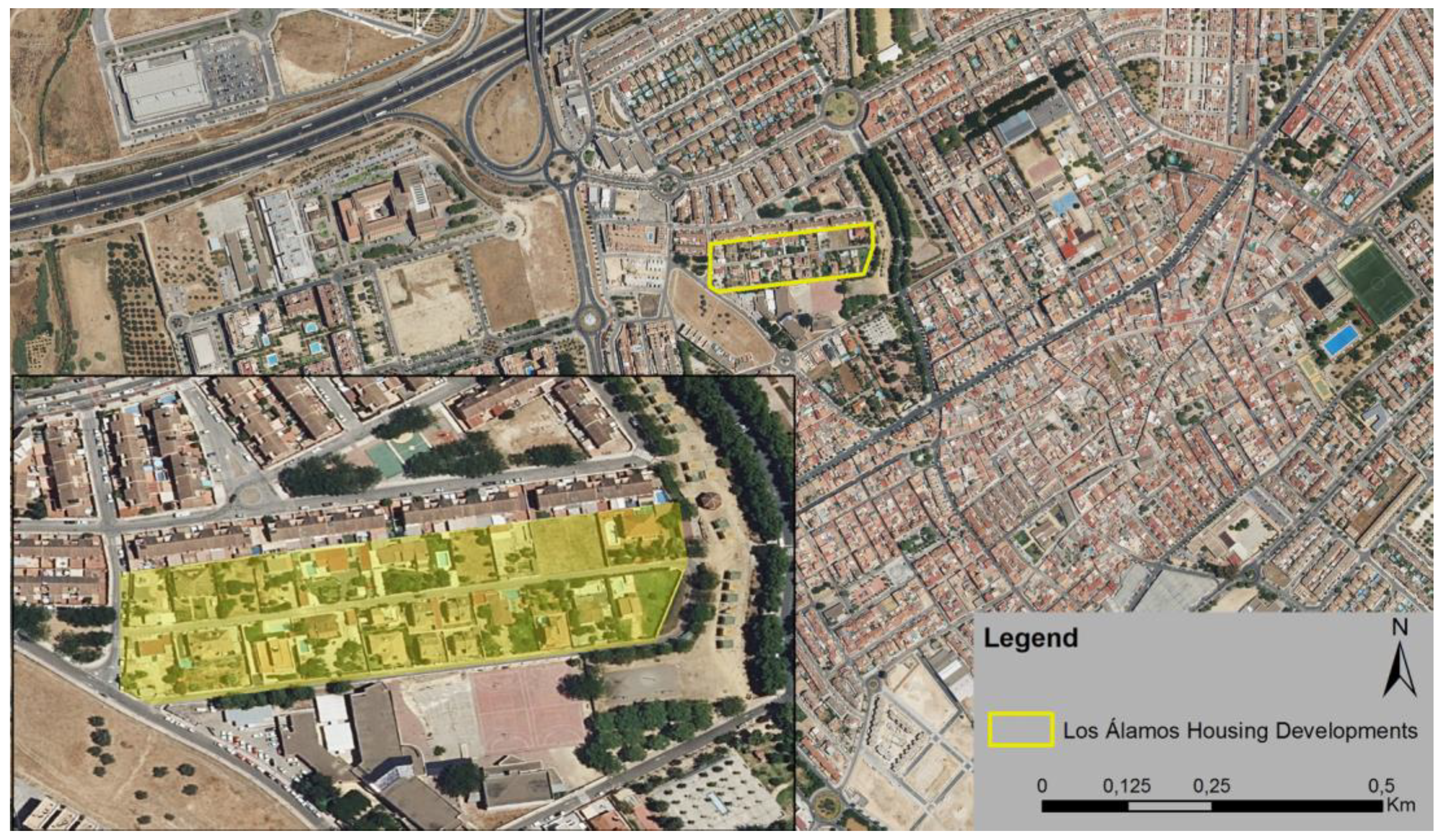
4.2.1. Illegal Housing Developments Integrated into the Existing Urban Fabric

The long period of time that has elapsed since the beginning of the illegal housing process and the strong urban dynamism that has characterised the growth of most of the country’s cities, especially in the metropolitan areas, has meant that many of the illegal housing developments that arose between the late 1960s and the mid-1980s have been absorbed into the urban fabric. This has occurred in cases in which, firstly, the settlements occupied spaces relatively close to the historic urban centre, and, secondly, the urban dynamism of the municipality has gone hand-in-hand with the socioeconomic situation of the country. Examples of this first typology can be found in the municipality of Mairena del Aljarafe (Ribera Porzuna housing development) or in Palomares del Río (Judío Grande and Chico housing development). However, perhaps the most paradigmatic example of this typology can be found in the illegal housing development Los Álamos, located today in the surroundings of the urban centre of the municipality of Bormujos (Figure 6). Therefore, this typology is defined as those illegal developments that have been absorbed into the planned urban fabric and integrated into it, although they maintain certain structural problems inherited from their unplanned origin that have not been resolved. In other words, the spatial limitations are limited to conditioning the road planning of the adjoining urban sectors.
As can be seen, this small housing development of irregular origin from the mid-1970s has been absorbed by the successive planned urban developments linked to the growth of the municipality itself. However, despite the fact that this urban sector is currently located within what could be called the consolidated urban fabric, in truth, it is not possible to speak of its successful integration into it. In this sense, both a detailed image of the area (Figure 6, lower left corner) and the result of fieldwork (Figure 7) allow us to assert that this former illegal housing development remains as a kind of urban island with the features and characteristics of its unplanned genesis (building typology and densities, road characteristics, etc.), although the passage of time and the urban dynamics of the municipality have caused it to be inserted into the current urban network.
As mentioned above, Figure 7 shows the access street to the Los Álamos development, where it is possible to see the contrast between the roadway resulting from unplanned development (narrow, without pavements and with deficient street lighting and invading the roadway) and the adjacent roadway, which is the result of planned urban development processes. This demonstrates that the simple fact of incorporating a housing development with these characteristics into the ordered city by classifying the land as urban does not solve the intrinsic problems associated with the unplanned origin of the settlement.

4.2.2. Illegal Housing Developments Partially Integrated into the Urban Fabric under Development

This typology groups together the illegal housing developments that, fundamentally, due to their location somewhat further away from the main nucleus of the municipality, have not been fully incorporated into its urban fabric. However, the strong urban dynamism of the first metropolitan areas, especially during the last expansion cycle of the economy, coinciding with the real estate boom, has led to their incorporation into new planned growth. However, in many cases, these urban developments are also shown as urban islands that are more or less consolidated by buildings and surrounded by areas that, for the most part, only have road construction. This has been caused by the bursting of the real estate bubble, which slowed down the execution of these new urban developments, together with the requirements imposed by the regional urban planning legislation, which enforces the execution of all infrastructure and roads prior to the construction of the building. Based on these premises, this typology would be defined as those illegal urbanisations which, despite their distance from the planned city, have been integrated, at least partially, into the new urban developments associated with the latest expansionary cycle of the real estate sector. In this sense, it can be affirmed that their location and need for legalisation may have conditioned the urban morphology of the municipality.
Most of the housing developments of this type are in the municipality of Mairena del Aljarafe (Figure 5) due, firstly, to the large number of illegal settlements identified (15), and, secondly, because the municipal plan approved in 2003 meant going from approximately 430 ha (290 ha urban land and 139 ha developable land) to 1110 ha (651.04 ha urban and 458.99 ha developable land). That is to say, land was classified to almost triple the size of the existing city so that after the approval of the new municipal plan, practically all the housing developments that initially arose outside the urban planning were within the area defined by the new urban growth.
An example of this typology appears in the Las Tres Barras housing development, located at the western end of the urban growth of the municipality of Mairena del Aljarafe (Figure 8). As can be seen, the extension of the city towards the site occupied by the settlement of irregular origin has allowed its connection and integration into the future urban expansion area. In general, this integration is made effective through the connection of the existing roads of this settlement with those planned for the new urban sectors. Likewise, the execution of the infrastructure and installation of the basic services (water supply, electricity and sewage network) required for the new real estate developments will allow access to the urban nucleus that, due to its irregular origin, did not have them or the legal possibility of establishing them.
As was the case for the previous typology, the simple fact of classifying the illegal housing development as urban land and, in this way, incorporating it into the urban planning order, does not solve the problems inherent to this type of settlement. The image (Figure 9) shows the state of the road: narrow, without pavements, with deficient water drainage and street lighting, etc.

4.2.3. Illegal Housing Developments Disconnected from the Urban Fabric of the Planned City

The last of the three established typologies groups together the set of illegal housing developments located outside or removed from the urban fabric of the planned city, although they may have areas of contact with its enclosing roads; generally, large avenues or perimeter boulevards. This type of settlement is present in most of the municipalities in the area analysed, but especially in Bormujos and Mairena del Aljarafe (Figure 5). Their position further away from the consolidated city, even on the very edges of the municipality, together with the existence of diverse territorial elements, makes their effective and orderly integration into the urban fabric of the municipality impossible. Many of these illegal housing developments, when they have been incorporated into urban planning through their classification as urban land, or more commonly, land for development, have done so only in part, leaving areas of the original settlement without the possibility of doing so, mainly due to the existence of sectorial conditions. In this sense, it is worth mentioning not only the illegal housing developments that have occupied areas of protection of public waterways or roads but also those that have invaded specially protected areas from an environmental or landscape perspective. Therefore, this typology would be defined as those illegal housing developments which, due to their position further away from the planned city, as well as their environmental, landscape or territorial impacts, make them impossible to legalise. Compared with the two previous typologies, their spatial implications are notably more important, given that, in general, they provoke significant impacts on the territory where they are present.
The housing development chosen as an example of the latter typology is called Rocío Chico 1–2 (Figure 10). Located at the western end of the municipality of Bormujos, very close to the route of the new metropolitan SE-40 ring road, it was originally formed by two areas separated by the road that links this municipality with the neighbouring municipality of Bollullos de la Mitación. As can be seen in Figure 10, only part of the original settlement (the one shaded in red) has been incorporated into urban planning, this time through its classification as unconsolidated urban land, that is, excluding the classification of rural land, which was a large part of the original areas. The reason for this is that the entire area of the municipality is classified as undeveloped land for special protection. In fact, the decision of the authorities has been to maintain as an urban area that which was already so consolidated that it could not be restored to its original state without significant social consequences.
Considering the data, these are the settlements whose integration into the planned city is not only more doubtful but also raises serious doubts as to their suitability, given all the kinds of effects on the territorial structures into which they are inserted. Only social or political motivations explain the decision to incorporate them into urban planning through their classification as urban or developable land. In the first case, because of the high social and economic cost of ordering the demolition of what has been illegally built and the restoration of the territory to its original state; and in the second, because of the political consequences, given that the scope of this phenomenon has reached such extremes that it can affect the election of local governors.

5. Discussion

5.1. Regarding Existing Literature and Other Reference Cases

The results of the article align the case of Seville with other Spanish cases, in general, and Andalusian cases, in particular, although with their own characteristics [11]. Strategies to illegally market land close to the central city in metropolitan areas have a long history in most Spanish cities [24], and not only in large cities, but also in medium-sized ones [12,75,76] and even in rural areas [43]. In large agglomerations, whose dynamics and territorial scope have changed greatly over the last decades, there is a greater diversity of situations. Seville, compared with Madrid [57], Barcelona [35], and even Valencia [41], experienced a more recent and explosive metropolitan development, largely in small and very rural municipalities until the 1980s. Moreover, the role of the central municipalities in their respective metropolitan areas (and other cities, such as Bilbao or Zaragoza, should be added) was more mature and the land markets, themselves more consolidated, at least in comparison with Seville, also prevented or hindered illegal expansion. The literature on other Spanish cities in this field reflected the virulence of some of these processes in the 1970s and 1980s of the last century, while in Seville, like other Andalusian capital cities of all ranks (from Cordoba to small rural towns), the process remained strong [61,77] and continues, albeit on a smaller scale, beyond the new century [42,47,78]. Consequently, through the case studies, this work shows quantitatively and qualitatively how Seville has been behind the rest of Spain in maintaining illegal urban development practices which, due to this circumstance and the speed of their development, have caused a series of problems that have already been mitigated in other Spanish cities [57] but which are still unresolved processes in numerous Andalusian towns and cities. Seville, the capital and the most populated nucleus of a region that is close in size to mainland Portugal, thus shows the contradictions imposed by the immaturity of the socioeconomic and territorial system in which it is located and is a good laboratory in which to contrast other cities with similar circumstances.

5.2. Regarding the Attitude of the Competent Authorities in the Field of Town and Country Planning in the Study Area

The central and local government authorities are aware, as seen through their own reports and independent investigations, of the extent of the changes occurring in illegal urbanisation in the metropolitan area of Seville [79]. However, their attitude is rarely profound and exemplary, especially because at the local level, there is still a perception that obstacles to this type of urbanisation are against the free will of landowners [80]. One can therefore allude to a social immaturity regarding the advantages of legal, coherent, and sustainable urban planning, which, however, seems to be diminishing in recent years. Demolition processes are infrequent and lengthy and do not always end with the re-establishment of urban planning legality. This is especially because the municipal authorities are unwilling to exercise a belligerent attitude towards illegal urbanisation which, at least in their perception (and it is not unfounded), could cause them to lose votes and, consequently, power. From the regional administration, which is responsible for legislation on urban and regional planning [70], there are two opposing positions. On the one hand, there is an attempt to address the long-standing and shocking influence of illegal urban development in the region. This is done with all kinds of measures (legal, publicity campaigns, etc.). On the other hand, there is the choice to interfere or not to interfere in municipal policies which, in the end, have much more experience, practice, and proximity to the citizens than the regional authority itself. The result tends to be an ambivalent, insecure, complacent attitude towards town councils and little or nothing exemplary with respect to illegal urban planning, which, we insist, tends to recede due to a process of social maturity that increasingly respects and understands the legal mechanisms that inform and develop urban planning practices.

6. Conclusions

6.1. General Conclusions on the Morphological and Sociopolitical Conditioning Factors Imposed by Illegal Urban Development

In Spain, informal housing is as old as the legal housing mechanisms themselves. During the last few decades, however, the process of squatting in metropolitan areas has been subject to a significant reduction and greater control; aspects that, nevertheless, have not made it disappear completely. Moreover, although their dynamism is much less, their consequences remain since these urban areas of very different characteristics always have in common, in addition to morphological disorder, that they establish tense environments in the local sociopolitics.
Regarding morphological disorder, which is obviously influenced by the extension and density of these housing developments, this generates elements that only respond to the interests of the original property of the estate and, subsequently, of the new owners so that the collective values of the territory, especially in areas as conflictive as those close to the cities, are subordinate to the individual ones. Thus, disregarding their surroundings, these areas cause problems of organised insertion (without adequate access, on land at risk, or unhealthy land, etc.), management of services, and landscape impacts, often in environments of remarkable environmental value. These facts, common to the entire history of the illegal housing process, are especially adverse at present when properly managed city environments are part of their image and not only a resource for their inhabitants but also a means for increasing their attractiveness and competitiveness.
Concerning the sociopolitical aspect, the spread of illegal housing developments has generated a characteristic social profile whose interests (fleeing regulatory uncertainty and securing capital gains on their properties when these are regularised) notably influence local policies in the municipalities where these housing developments are most abundant. Whether they are people already registered in these municipalities (and, therefore, with more effective rights) or foreign owners, their influence is strengthened by their ability to form associations or, at least, to unite voices in demand for legalisation and services for their housing developments. The number and influence of this social profile (willing to support the parties that promise the regularisation of their housing developments at any price) usually causes the aspiring mayors of these municipalities to be open to their claims and, if they do not deal with them directly because they are beyond their competence, they act as advocates before higher administrative bodies: those of autonomous regions (especially in regards to urban planning, land use planning, environment, etc.). In this way, the local authorities have not only paid little attention to the construction processes of these housing developments but, to the extent of their possibilities, they have helped to solve their management problems. The regional authorities, although more distanced from these processes, nevertheless end up compromising, albeit with long and complex processes, through regulations that allow the regularisation of these housing developments, except for those that totally or partially entail a breach of other laws (especially environmental laws) that are difficult to justify.

6.2. Conclusions Regarding the Integration of Marginal Housing Developments in the Study Area: Eastern Sector of Aljarafe

This article has provided information and arguments for a better understanding of the process of illegal housing in the metropolitan area of Seville, particularly in its western sector, one of the most significant in terms of its environmental and landscape values. In general, it can be stated that after the development of the illegal housing model for more than six decades, related firstly to leisure and, in some cases, subsequently, as second homes, many of these residential areas have been reached by the processes of urban growth and integrated into the new metropolitan mosaic as areas with a better or worse territorial fit. In any case, they have always acted as a conditioning factor for urban development processes, and even when these have been included in the urban continuum, they continue to be largely unconnected, isolated spaces that, in many cases, are without a definitive solution. Their service coverage and access to major metropolitan highways are always in worse conditions than the settlements resulting from regulated urban development.
In the future, it is to be expected that the aspects related to poor materials and access conditions, internal urbanisation, and services of these developments will improve. It is also foreseeable that control mechanisms will increase and that this process will lose momentum and specific weight in metropolitan areas, such as Seville, which are increasingly complex but tend to be regulated. The loss of demographic momentum but not so much in economic and urban planning, in general, suggests that the processes of generating urban capital gains will continue and will seek new forms of expansion in the coming decades. The metropolitan area of Seville still has many aspects to resolve in all areas (structural, environmental, landscape, etc.). In this task, the correct assessment of the legacy of illegal urban planning over so many decades, in addition to being a puzzle, can also be an area from which, with good knowledge, lessons and new opportunities can be drawn. While in the 1980s and 1990s, the great field of reflection was the city’s historical centre, today, that reflection navigates, recognises, and investigates its metropolitan area.

Author Contributions

Introduction, D.L.-C. and V.F.-S.; Methodology, D.L.-C.; Case study: The metropolitan area of Seville, V.F.-S.; Results, discussion, and conclusions, D.L.-C. and V.F.-S.; Writing and revision of the manuscript, D.L.-C. and V.F.-S. All authors have read and agreed to the published version of the manuscript.

Funding

This research received no external funding.

Data Availability Statement

Data are contained within the article.

Conflicts of Interest

The authors declare no conflict of interest.

References

  1. Matarira, D.; Mutanga, O.; Naidu, M.; Vizzari, M. Object-Based Informal Settlement Mapping in Google Earth Engine Using the Integration of Sentinel-1, Sentinel-2, and Planet Scope Satellite Data. Land 2023, 12, 99. [Google Scholar] [CrossRef]
  2. Arévalo, M.; Bazoberry, G.; Blanco, C.; Díaz, S.; Fernández, R.; Florian, A.; Quispe, R.G.; González, G.; Landaeta, G.; Manrique, D.; et al. El Camino Posible. Producción Social del Hábitat en América Latina; Ediciones Trilce: Montevideo, Uruguay, 2012. [Google Scholar]
  3. Ortiz Flores, E. Producción social de vivienda y hábitat: Bases conceptuales para una política pública. In El Camino Posible. Producción Social del Hábitat en América Latina; Arévalo, M., Bazoberry, G., Blanco, C., Díaz, S., Fernández, R., Florian, A., Quispe, R.G., González, G., Landaeta, G., Manrique, D., et al., Eds.; Ediciones Trilce: Montevideo, Uruguay, 2012; pp. 13–40. [Google Scholar]
  4. Pradilla Cobos, E. El mito neoliberal de la “informalidad” urbana. In Más Allá de la Informalidad; Craggio, J.L., Pradilla, E., Ruiz, L., Unda, M., Eds.; Research Center: Quito, Ecuador, 1995; pp. 29–52. [Google Scholar]
  5. Harvey, D. Urbanismo y Desigualdad Social; Siglo Veintiuno de España: Madrid, Spain, 1979. [Google Scholar]
  6. Harvey, D. Espacios del Capital: Hacia una Geografía Crítica; Akal: Madrid, Spain, 2007. [Google Scholar]
  7. López-Casado, D. Metodología para el análisis y la caracterización geográfica de la ciudad informal: Urbanizaciones ilegales en el municipio de Córdoba, España. Quid 16 Rev. Del Área De Estud. Urbanos 2022, 17, 99–120. Available online: https://publicaciones.sociales.uba.ar/index.php/quid16/article/view/7107 (accessed on 15 September 2023).
  8. Grashoff, U. Comparative Approaches to Informal Housing around the Globe; UCL Press: London, UK, 2022. [Google Scholar] [CrossRef]
  9. Chiodelli, F.; Tzfadia, E. The Multifaceted Relation between Formal Institutions and the Production of Informal Urban Spaces: An Editorial Introduction. Geogr. Res. Forum 2016, 36, 1–14. [Google Scholar]
  10. Roy, A. Urban Informality: Toward an Epistemology of Planning. J. Am. Plan. Assoc. 2005, 71, 147–158. [Google Scholar] [CrossRef]
  11. Lois González, R.C.; Piñeira, M.J.; Vives-Miró, S. El proceso urbanizador en España (1990–2014): Una interpretación desde la geografía y la teoría de los circuitos de capital. Scr. Nova Rev. Electron. Geogr. Cienc. Soc. 2016, 20, 539. [Google Scholar] [CrossRef]
  12. Andrés López, G. Recent Transformations in the Morphology of Spanish Medium-Sized Cities: From the Compact City to the Urban Area. Land 2023, 12, 1276. [Google Scholar] [CrossRef]
  13. López-Casado, D. De urbanización ilegal de fin de semana a barrio precario: Las parcelaciones ilegales en Córdoba. Ciudades 2021, 24, 225–246. [Google Scholar] [CrossRef]
  14. Kropf, K. The Handbook of Urban Morphology; John Wiley & Sons: Chichester, UK, 2018. [Google Scholar]
  15. Tellman, B.; Eakin, H.; Turner, B.L. Identifying, projecting, and evaluating informal urban expansion spatial patterns. J. Land Use Sci. 2022, 17, 100–112. [Google Scholar] [CrossRef]
  16. Tonkiss, F. Cities by Design: The Social Life of Urban Form; John Wiley & Sons: Chichester, UK, 2014. [Google Scholar]
  17. Pojani, D. The self-built city: Theorising urban design of informal settlements. Archnet-IJAR Int. J. Archit. Res. 2019, 13, 294–313. [Google Scholar] [CrossRef]
  18. Soliman, A.M. Urban Informality: Experiences and Urban Sustainability Transitions in Middle East Cities; Springer: Switzerland, 2021. [Google Scholar]
  19. Chiodelli, F.; Mazzolini, A. Inverse planning in the cracks of formal land use regulation: The bottom-up regularisation of informal settlements in Maputo, Mozambique. Plan. Theory Pract. 2019, 20, 165–181. [Google Scholar] [CrossRef]
  20. Zied Abozied, E.; Vialard, A. Reintegrating informal settlements into the Greater Cairo Region of Egypt through the regional highway network. Reg. Stud. Reg. Sci. 2020, 7, 333–345. [Google Scholar] [CrossRef]
  21. Roch Peña, F.; Sáez, E. Ciudad, vivienda y hábitat en los barrios informales de Latinoamérica. In Proceedings of the Congreso Cudad, Territorio y Paisaje. Una Mirada Multidisciplinar, Madrid, Spain, 5 May 2010–7 May 2010; pp. 105–119. Available online: https://oa.upm.es/8889/ (accessed on 15 September 2023).
  22. Whitehand, J.W. Recent advances in urban morphology. Urban Stud. 1992, 29, 619–636. [Google Scholar] [CrossRef]
  23. McCartney, S.; Krishnamurthy, S. Neglected? Strengthening the morphological study of informal settlements. Sage Open 2018, 8. [Google Scholar] [CrossRef]
  24. Potsiou, C. Policies for formalization of informal development: Recent experience from southeastern Europe. Land Use Policy 2014, 36, 33–46. [Google Scholar] [CrossRef]
  25. Chiodelli, F. The Dark Side of Urban Informality in the Global North: Housing Illegality and Organized Crime in Northern Italy. Int. J. Urban Reg. Res. 2019, 43, 497–516. [Google Scholar] [CrossRef]
  26. Calor, I.; Alterman, R. When enforcement fails. Comparative analysis of the legal and planning responses to non-compliant development in two advanced-economy countries. Int. J. Law Built Environ. 2017, 9, 207–239. [Google Scholar] [CrossRef]
  27. Can Iban, M. Lessons from approaches to informal housing and non-compliant development in Turkey: An in-depth policy analysis with a historical framework. Land Use Policy 2020, 99, 105104. [Google Scholar] [CrossRef]
  28. Capel, H. Capitalismo y Morfología Urbana en España; Libros de la Frontera: Barcelona, Spain, 1975. [Google Scholar]
  29. Busquets Grau, J. La Urbanización Marginal; Polytechnic University of Catalonia: Barcelona, Spain, 1999. [Google Scholar]
  30. De Solá-Morales Rubió, M. La urbanización marginal y la formación de plusvalía del suelo. Pap. Rev. De Sociol. 1974, 3, 365–380. [Google Scholar] [CrossRef]
  31. De Solá-Morales Rubió, M.; Busquets, J.; Domingo Clota, M.; Font Arellano, A. Notas sobre la marginalidad urbanística. Cuadernos de Arquitectura y Urbanismo 1971, 86, 85–91. [Google Scholar]
  32. López-Casado, D. Un fenómeno urbano enquistado en el cambio de paradigma de la urbanización informal: Parcelaciones ilegales en el municipio de Córdoba. Bol. Asoc. Geógr. Esp. 2021, 90, 1–43. [Google Scholar] [CrossRef]
  33. Ortega Valcárcel, J. Residencias Secundarias y Espacio de Ocio en España. (Secondary Residences and Leisure Space in Spain); University of Valladolid: Valladolid, Spain, 1975. [Google Scholar]
  34. Valenzuela Rubio, M. La residencia secundaria en la provincia de Madrid: Génesis y estructura espacial. Ciudad. Territorio. Revista de Ciencia Urbana 1976, 2, 135–152. [Google Scholar]
  35. Nel-lo i Colóm, O. Estrategias para la contención y gestión de las urbanizaciones de baja densidad en Cataluña. Ciudad. Territorio. Estud. Territ. 2011, 43, 81–98. [Google Scholar]
  36. Betrán Abadía, R.; Franco Hernández, Y. Parcelaciones Ilegales de Segunda Residencia: El caso Aragonés; General Council of Aragón, Department of Territorial Planning, Public Works and Transport: Zaragoza, Spain, 1994. [Google Scholar]
  37. Ezquiaga Domínguez, J.M. Parcelaciones ilegales en suelo no urbanizable: Nuevas formas de consumo del espacio en los márgenes de la ley del suelo. Ciudad. Territorio. Rev. Cienc. Urbana 1983, 59–72. [Google Scholar]
  38. de Jaló;n, G.; Lastra, A.; Sainz, J.L.; Ezquiaga, J.M.; Moya, L. Estudio de las parcelaciones ilegales de la provincia de Valladolid. In Estudio de las Parcelaciones Ilegales de la Provincia de Valladolid; Official Association of Architects of Valladolid: Valladoli, Spain, 1986; p. 199. [Google Scholar]
  39. García-Bellido, J. La cuestión rural. Indagaciones sobre la producción del espacio rústico. Ciudad. Territorio. Estud. Territ. 1986, 9–52. [Google Scholar]
  40. Herce Vallejo, M. El consumo de espacio en las urbanizaciones de segunda residencia en Cataluña. Ciudad. Territorio. Estud. Territ. 1975, 45–56. [Google Scholar]
  41. Burriel de Orueta, E.L. La larga huella en el territorio de las viviendas secundarias ilegales. El ejemplo de Gilet (Valencia). Cuad. Geogr. Univ. València 2019, 107–140. [Google Scholar] [CrossRef]
  42. Górgolas Martín, P. Planeamiento urbanístico y suburbanización irregular en el litoral andaluz: Directrices y recomendaciones para impulsar la integración urbano-territorial de asentamientos. Ciudad. Territ. Estud. Territ. 2018, 33–52. [Google Scholar]
  43. Jiménez Barrado, V. Urbanizaciones Ilegales en Extremadura; La Proliferación de Viviendas en el Suelo No Urbanizable Durante el Período Democrático: Extremadura, Spain, 2018. [Google Scholar]
  44. Jiménez Barrado, V.; Delgado, C.; Campesino, A.-J. Desregulación urbanística del suelo rústico en España: Cantabria y Extremadura como casos de estudio. Rev. Geogr. Norte Gd. 2017, 73–92. [Google Scholar] [CrossRef]
  45. López-Casado, D. Illegal Parcelling in Cordoba (Spain): The Result of Illegal Urban Planning or Hidden City Development? Dela 2020, 125–148. [Google Scholar] [CrossRef]
  46. López-Casado, D. La informalidad como nexo: Producción social del hábitat en ciudades latinoamericanas frente a parcelaciones ilegales en España. ACME Int. J. Crit. Geogr. 2020, 19, 706–724. [Google Scholar]
  47. López-Casado, D.; Mulero, A. El fenómeno de las parcelaciones urbanísticas ilegales en Andalucía: Significado general y tratamiento en los planes de ordenación del territorio. Cuad. Geogr. 2021, 60, 171–191. [Google Scholar] [CrossRef]
  48. López-Casado, D. Hidden City: The Footprint of Illegal Urbanisation in Spain. In Hidden Geographies; Krevs, M., Ed.; Springer: Cham, Switzerland, 2021; pp. 313–334. [Google Scholar] [CrossRef]
  49. Moore-Cherry, N.; Kayanan, C.M.; Tomaney, J.; Pike, A. Governing the Metropolis: An International Review of Metropolitanisation, Metropolitan Governance and the Relationship with Sustainable Land Management. Land 2022, 11, 761. [Google Scholar] [CrossRef]
  50. Fuguitt, G.V.; Heaton, T.B.; Lichter, D.T. Monitoring the metropolitanisation process. Demography 1988, 25, 115–128. [Google Scholar] [CrossRef]
  51. Kübler, D. Introduction: Metropolitanisation and metropolitan governance. Eur. Political Sci. 2012, 11, 402–408. [Google Scholar] [CrossRef]
  52. Elliott, J.R. Cycles within the system: Metropolitanisation and internal migration in the US, 1965–90. Urban Stud. 1997, 34, 21–41. [Google Scholar] [CrossRef]
  53. Vinuesa Angulo, J. Procesos y estructuras geodemográficas en la metropolitanización: Propuestas de debate sobre algunas cuestiones básicas. In La Población en Clave Territorial. Procesos, Estructuras y Perspectivas de Análisis; De Cos, O., Reques, P., Eds.; Ministerio de Economía, Industria y Competitividad: Madrid, Spain, 2012; pp. 12–20. [Google Scholar]
  54. Oriol, N. La tercera fase del proceso de metropolitanización en España. In Los Procesos Urbanos Postfordistas; Artigues, A., Bauzà, A., Blázquez, M., Murray, I., Rullán, O., Eds.; Universidad de las Islas Baleares y Association of Spanish Geographers: Palma de Mallorca, Spain, 2007; pp. 19–31. [Google Scholar]
  55. Delgado Viñas, C. Los procesos de metropolitanización dispersa: Castro Urdiales (Cantabria) en la región urbana de Bilbao. Bol. Asoc. Geóg. Esp. 2018, 78, 474–517. [Google Scholar] [CrossRef]
  56. Feria Toribio, J. Los procesos metropolitanos en España: Intensificación estructural y nuevos desafíos. Papers 2018, 61, 28–40. Available online: https://ddd.uab.cat/record/202405 (accessed on 15 September 2023).
  57. Coq Huelva, D. Crecimiento suburbano difuso y sin fin en el Área Metropolitana de Sevilla entre 1980 y 2010. Algunos elementos explicativos. Scr. Nova Rev. Electrón. Geogr. Cienc. Soc. 2012, 16, 387–424. [Google Scholar]
  58. Feria Toribio, J.M.; Andújar, A. Movilidad residencial metropolitana y crisis inmobiliaria. An. Geogr. Univ. Complut. 2015, 35, 13–40. [Google Scholar] [CrossRef]
  59. Vega González, G. Las áreas metropolitanas andaluzas. Sevilla. In Areas Metropolitanas de España. La Nueva Forma de la Ciudad; Rodríguez, F., Ed.; Universidad de Oviedo, Servicio de Publicaciones: Oviedo, Spain, 2009; pp. 135–158. [Google Scholar]
  60. García García, A.; Caravaca, I. El Debate sobre los territorios inteligentes: El caso del área metropolitana de Sevilla. EURE 2009, 105, 23–45. Available online: http://www.eure.cl/index.php/eure/article/view/1389 (accessed on 15 September 2023).
  61. Recuenco Aguado, L. Frente al “Potaus”: Área Metropolitana y “Plan Subregional de Ordenación del Territorio de la Aglomeración Urbana de Sevilla” (In front of the “Potaus”: Metropolitan Area and “Plan Subregional de Ordenación del Territorio de la Aglomeración Urbana de Sevilla); Universidad de Sevilla: Sevilla, Spain, 2008. [Google Scholar]
  62. General Directorate of Urban Planning. Inventario de Parcelaciones Urbanísticas de la Provincia de Sevilla: Análisis y Diagnóstico; Junta of Andalusia, Regional Ministry of Environment and Territory: Seville, Spain, 1989; pp. 1–96. [Google Scholar]
  63. General Directorate of Territorial Planning and Urban Development. Inventario de Parcelaciones Urbanísticas en Suelo no Urbanizable en Andalucía (Memoria); General Directorate of Territorial Planning and Urban Development. Regional Ministry of Public Works and Transport, Junta of Andalusia, General Directorate of Urban Development: Seville, Spain, 2004; pp. 1–118. [Google Scholar]
  64. Marín de Terán, L. Sevilla: Centro Urbano y Barriadas; Servicio de Publicaciones: Seville, Spain, 1980. [Google Scholar]
  65. González Dorado, A. Sevilla: Centralidad Regional y Organización Interna de su Espacio Urbano (1900–1970); Banco Urquijo Publications Service: Seville, Spain, 1975. [Google Scholar]
  66. Decree 267/2009, of June 9, 2009, Approving the Spatial Plan for the Urban Agglomeration of Seville (BOJA No. 132 of 9 July 2009). Available online: https://www.juntadeandalucia.es/boja/2009/132/59 (accessed on 15 September 2023).
  67. Comunidad de Madrid. Urbanizaciones Ilegales. Programa de Actuación; Information and Documentation Center of the Regional Ministry of Land Management, Environment and Housing: Madrid, Spain, 1984; pp. 1–87. [Google Scholar]
  68. Provincial Council of Valencia. Urbanismo y Medio Rural. In Valencia: La vivienda Ilegal de Segunda Residencia; Provincial Council of Valencia: Valencia, Spain, 1983. [Google Scholar]
  69. Requena Sánchez, M.D. Organización Espacial y Funcional de la Residencia Secundaria en la Provincia de Sevilla; Universidad de Sevilla: Seville, Spain, 1987; Unpublished. [Google Scholar]
  70. Department of Environment and Territorial Planning. Plan de Ordenación del Territorio de la Aglomeración Urbana de Sevilla. (Plan for Territorial Planning for the Urban Agglomeration of Seville.); Junta of Andalusia, Regional Ministry of Environment and Territory: Seville, Spain, 2009; pp. 1–150. [Google Scholar]
  71. Sancho Martí, J. Conjuntos residenciales al margen del planeamiento en la periferia de Zaragoza. Geographicalia 1989, 26, 279–286. [Google Scholar] [CrossRef]
  72. Sancho Martí, J. El Espacio Periurbano de Zaragoza; Zaragoza City Council, Area of Culture and Education, Cultural Action Service: Zaragoza, Spain, 1989; Volumen I y II. [Google Scholar]
  73. Pie i Ninot, R.; Navarro, F. De los “establiments” a las parcelaciones ilegales. Ciudad. Territorio. Estud. Territ. 1988, 75-1, 55–80. [Google Scholar]
  74. Junta de Castilla y León. Plan Regional de Ámbito Sectorial Sobre Parcelaciones Ilegales: Metodología, Inventario y Diagnóstico; Junta de Castilla y León: León, Spain, 2003. [Google Scholar]
  75. Fajardo de la Fuente, A.F. La pérdida de los valores paisajísticos y ambientales en el término municipal de Osuna por la proliferación de urbanizaciones ilegales. Cuad. Amigos Mus. Osuna 2003, 5, 17–23. [Google Scholar]
  76. Jiménez Fernández, M.C. Estudio de la vivienda irregular en Sevilla: El caso de Marchena. Espac. Tiempo Rev. Cienc. Hum. 2014, 28, 23–38. [Google Scholar]
  77. Defensor del Pueblo Andaluz. Las urbanizaciones ilegales en Andalucía. Informe Especial al Parlamento Andaluz; Defensor del Pueblo Andaluz: Sevilla, Spain, 2000; Available online: https://www.defensordelpuebloandaluz.es/sites/default/files/Recomendaciones_urb_ilegales.pdf (accessed on 15 September 2023).
  78. Fernández Rivera, F.J. Parcelaciones y Viviendas en Suelo Rústico en Torno a Grandes ejes Viarios. La Accesibilidad del Territorio Como Motor de Urbanización Irregular; Depósito de Investigación de la Universidad de Sevilla: Sevilla, Spain, 2022; Available online: https://idus.us.es/handle/11441/141379 (accessed on 22 September 2023).
  79. Górgolas Martín, P. Sevilla ante el reto metropolitano: Del fracaso institucional a la mercantilización territorial. Astrágalo Cult. Arquit. Ciudad. 2019, 26, 15–48. [Google Scholar] [CrossRef]
  80. Gómez Reina, J.J. Evolución del primer ayuntamiento democrático de la ciudad de Sevilla. Hist. Actual Online 2018, 45, 131–143. [Google Scholar]
Figure 1. Metropolitan area of Seville in 2009, zoning according to Potaus and structures. Prepared by the authors based on Potaus and the DERA.
Land 12 02108 g001
Figure 2. Scope of study: municipal delimitation and territorial structure. Prepared by the authors based on the DERA.
Land 12 02108 g002
Figure 3. Location of illegal housing developments in the central sector of the metropolitan area of Seville. Prepared by the authors based on the 2003 Inventory of the Junta of Andalusia and the DERA.
Land 12 02108 g003
Figure 4. Location of illegal housing developments in the study area according to the 1988 and 2003 inventories. Prepared by the authors based on the 1988 and 2003 inventories, the DERA and Potaus.
Land 12 02108 g004
Figure 5. Location of the different types of illegal housing developments in the study area. Prepared by the authors based on the inventories of the Junta of Andalusia of 1988 and 2003, municipal urban planning, and 2022 Orthophotography of the National Aerial Orthophotography Plan (PNOA).
Land 12 02108 g005
Figure 6. Location of the Los Álamos housing development in the municipality of Bormujos. Prepared by the authors based on the inventories of the Junta of Andalusia of 1988 and 2003, municipal urban planning, and 2022 Orthophotography of the National Aerial Orthophotography Plan (PNOA).
Land 12 02108 g006
Figure 7. Access road to Los Álamos, municipality of Bormujos. The authors (2023).
Land 12 02108 g007
Figure 8. Location of the Las Tres Barras housing development in the municipality of Mairena del Aljarafe. Prepared by the authors based on the inventories of the Junta of Andalusia of 1988 and 2003, municipal urban planning, and 2022 Orthophotography of the National Aerial Orthophotography Plan (PNOA).
Land 12 02108 g008
Figure 9. Interior street of the Las Tres Barras housing development, municipality of Mairena del Aljarafe. The authors (2023).
Land 12 02108 g009
Figure 10. Location of the Rocío Chico 1–2 housing development in the municipality of Bormujos and its relationship with the original settlements. Prepared by the authors based on the inventories of the Junta of Andalusia of 1988 and 2003, municipal urban planning, and 2022 Orthophotography of the National Aerial Orthophotography Plan (PNOA).
Land 12 02108 g010
Table 1. Data on the evolution of the population in the different spatial areas. Prepared by the authors based on Population and Housing Censuses.
Spatial Scope1996 Population2022 Population% Variation
Andalusia7,234,8738,500,18714.89%
Seville (provincial)1,705,3201,948,39312.48%
Seville (central city)697,487681,998−2.27%
Metropolitan area1,317,9851,547,64014.84%
Municipalities in the study area147,917214,11730.92%
Table 2. Evolution of the number of dwellings in the different spatial areas. Prepared by the authors based on Population and Housing Censuses.
1991 Census2011 Census
No. of Dwellings% Non-Principal DwellingsNo. of Dwellings% Non-Principal Dwellings%Variation No. of Dwellings%Variation Non-Principal
Dwellings
Metropolitan area438,36522.06%686,41019.29%57.58%−2.77%
Seville (central city)246,03619.93%337,22520.40%37.06%0.47%
Study area44,39123.61%86,01518.24%93.77%−5.37%
Table 3. Evolution of the illegal housing process and its relationship with its location within the metropolitan area. Prepared by the authors based on the Inventories of the Junta of Andalusia.
1988 Inventory2003 1 Inventory1988/2003 Inventory Variation
No. of PlotsTotal PlotsMunicipalitiesNo. of PlotsTotal PlotsMunicipalitiesNo. of PlotsTotal PlotsMunicipalities
First area1082321.911961897.310−43.52%−61.36%−47.37%
Second area1233525.6516961118.8212−21.95%−68.27%−25.00%
Totals2315847.56351572016.1222−32.03%−65.52%−37.14%
1 Only those located on undeveloped land are counted.
Disclaimer/Publisher’s Note: The statements, opinions and data contained in all publications are solely those of the individual author(s) and contributor(s) and not of MDPI and/or the editor(s). MDPI and/or the editor(s) disclaim responsibility for any injury to people or property resulting from any ideas, methods, instructions or products referred to in the content.

