Land Suitability of Urban and Industrial Development Using Multi-Criteria Evaluation (MCE) and A New Model by GIS in Fasa County, Iran
Abstract
1. Introduction
2. Materials and Methods
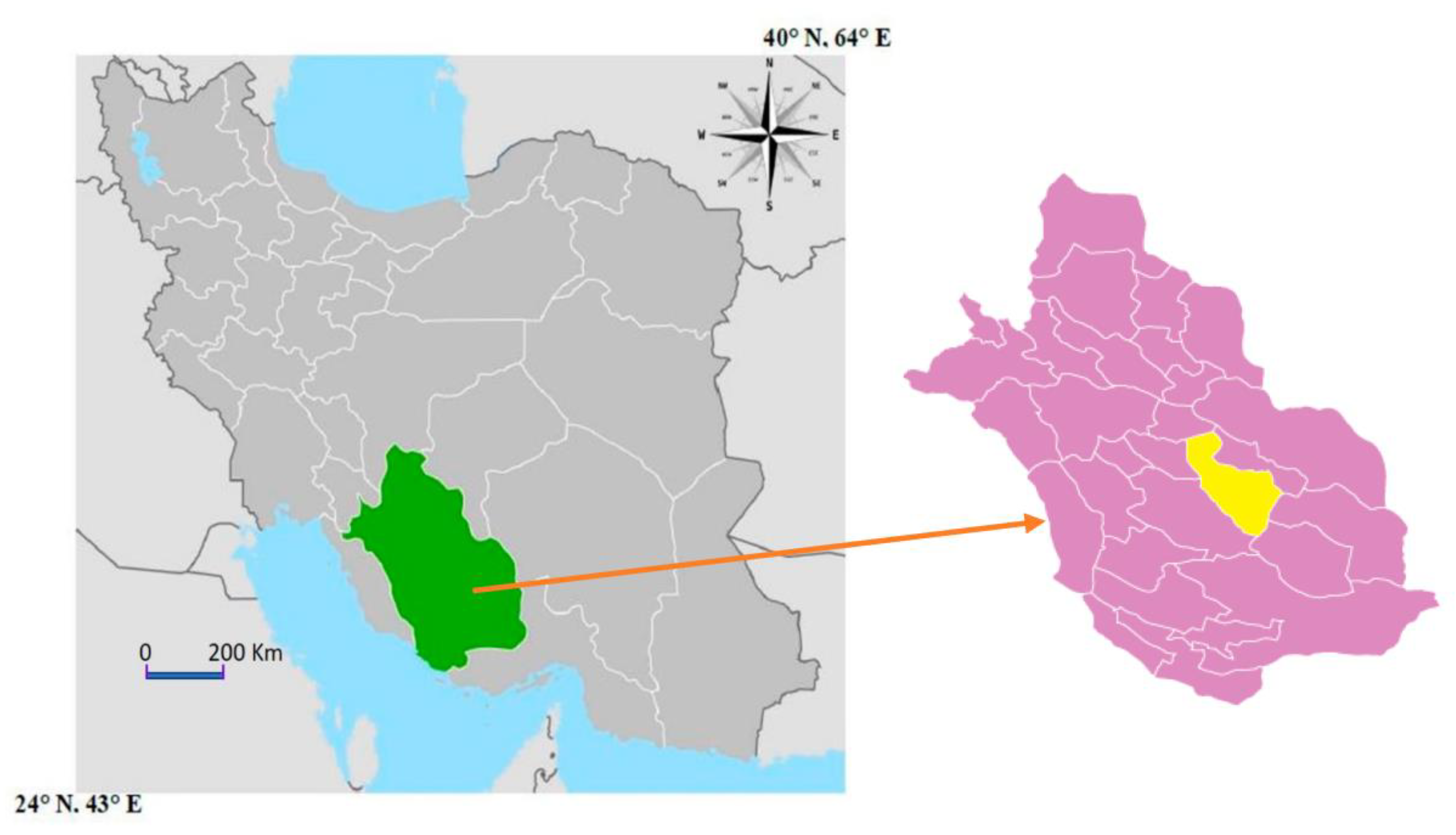
2.1. Study Area
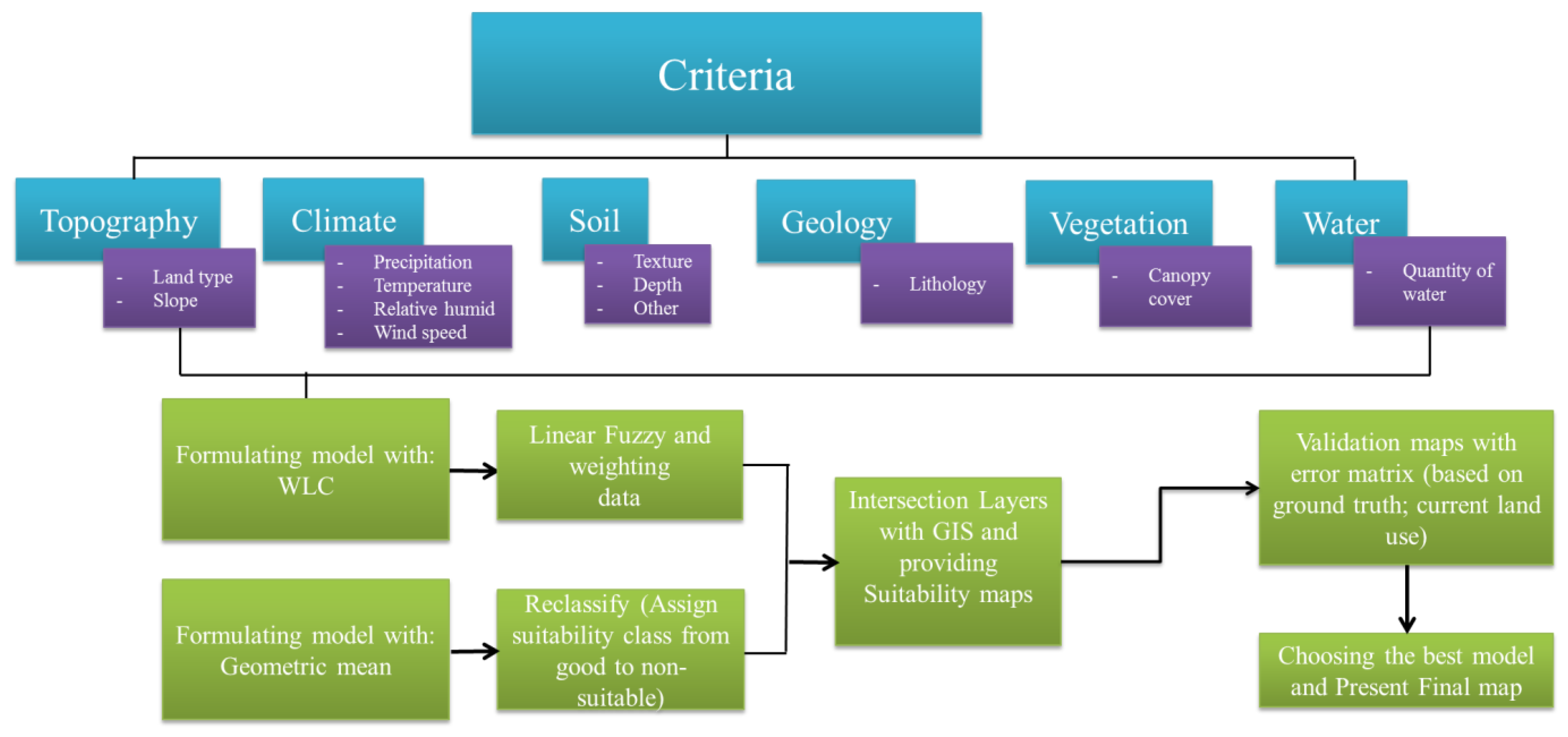
2.2. Methodology
2.2.1. Description and Reclassification of Indicators
2.2.2. Evaluation and Formulation of the Proposed Model Based on the Geometric Mean and WLC
2.2.3. Validation Models
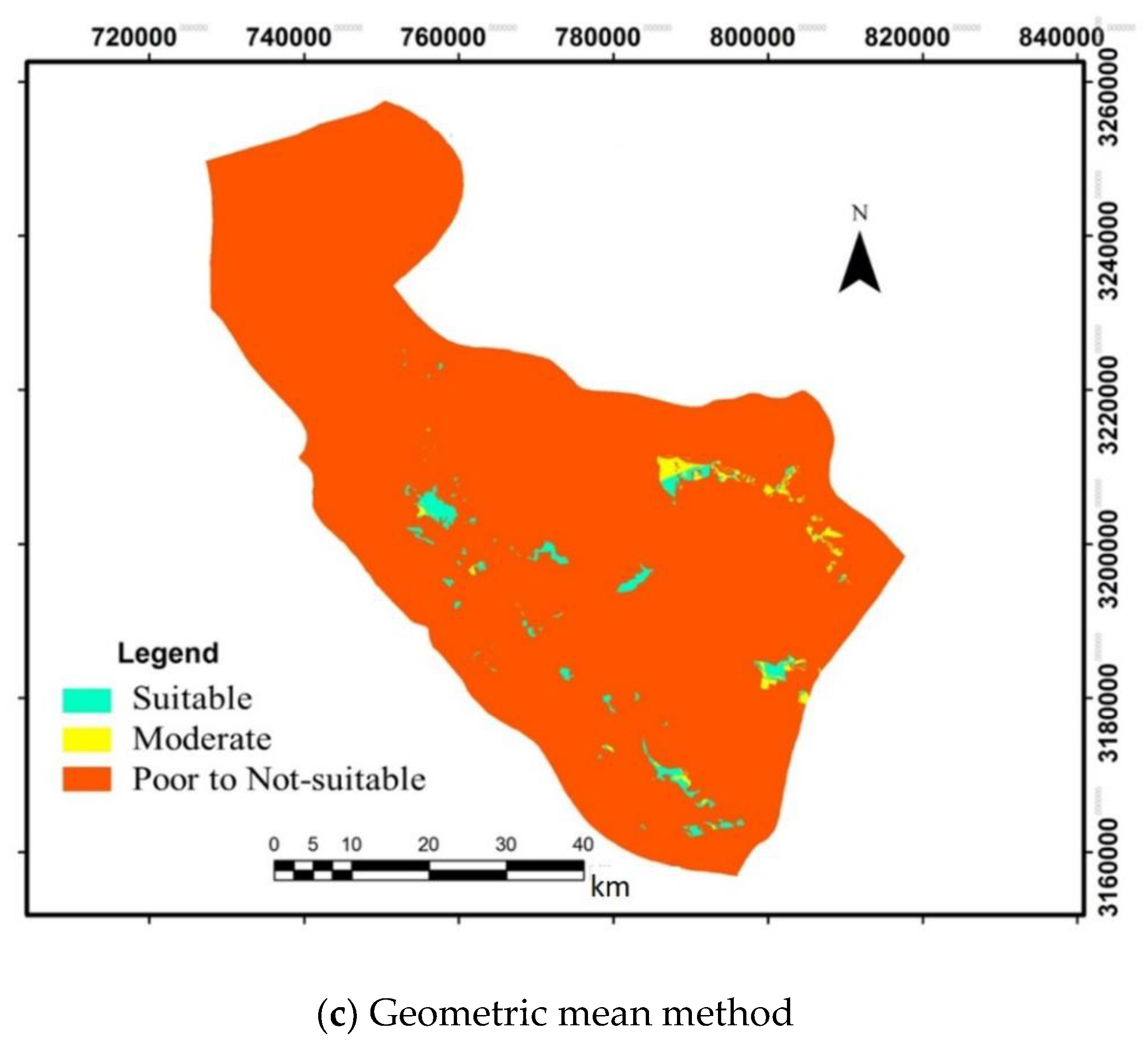
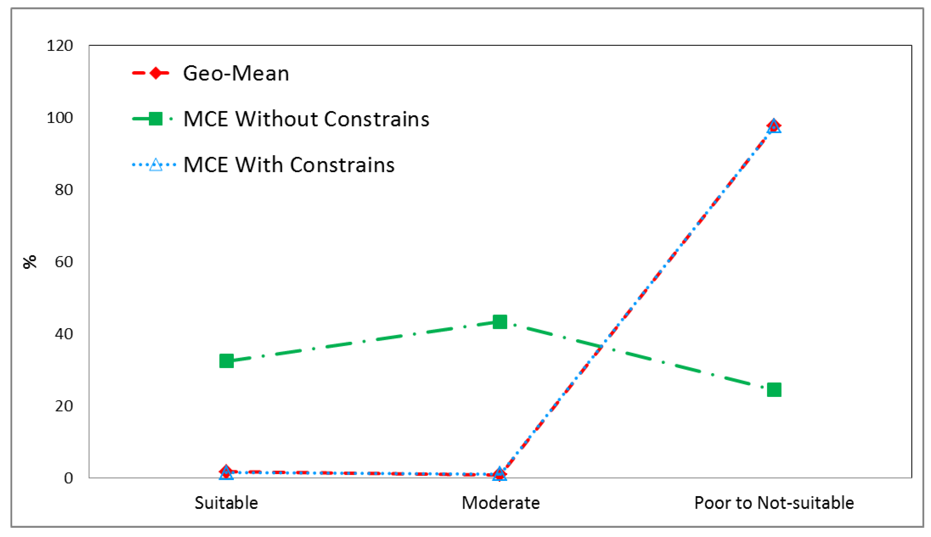
3. Results
4. Discussion
5. Conclusions
Author Contributions
Funding
Data Availability Statement
Acknowledgments
Conflicts of Interest
References
- Adelle, C.; Weiland, S. Policy assessment: The state of the art. Impact Assess. Proj. Apprais. 2012, 30, 25–33. [Google Scholar] [CrossRef]
- Malmir, M.; Zarkesh, M.M.K.; Monavari, S.M.; Jozi, S.A.; Sharifi, E. Analysis of land suitability for urban development in Ahwaz County in southwestern Iran using fuzzy logic and analytic network process (ANP). Environ. Monit. Assess. 2016, 188, 447. [Google Scholar] [CrossRef] [PubMed]
- Bond, A.; Morrison-Saunders, A.; Pope, J. Sustainability assessment: The state of the art. Impact Assess. Proj. Apprais. 2012, 30, 53–62. [Google Scholar] [CrossRef]
- Yalew, S.G.; Van Griensven, A.; Van der Zaag, P. AgriSuit: A web-based GIS-MCDA framework for agricultural land suitability evaluation. Comput. Electron. Agric. 2016, 128, 1–8. [Google Scholar] [CrossRef]
- Sonneveld, M.P.W.; Hack-ten Broeke, M.J.D.; Van Diepen, C.A.; Boogaard, H.L. Thirty Years of Systematic Land Evaluation in the Netherlands. Geoderma 2010, 156, 84–92. [Google Scholar] [CrossRef]
- Elsheik, A.R.; Ahmad, N.; Shariff, A.; Balasundra, S.; Yahaya, S. An Agricultural Investment Map Based on Geographic Information System and Multi-Criteria Method. J. Appl. Sci. 2010, 10, 1596–1602. [Google Scholar] [CrossRef][Green Version]
- Pan, G.; Pan, J. Research in crop land suitability analysis based on GIS. Comput. Comput. Technol. Agric. 2012, 5, 314–325. [Google Scholar] [CrossRef]
- Shukla, A.; Kumar, V.; Jain, K. Site suitability evaluation for urban development using remote sensing, GIS and analytic hierarchy process (AHP). In Proceedings of the International Conference on Computer Vision and Image Processing, Roorkee, India, 9–12 September 2017; Springer Science: Singapore, 2017. [Google Scholar]
- Nengroo, Z.A.; Bhat, M.S.; Kuchay, N.A. Measuring urban sprawl of Srinagar City, Jammu and Kashmir, India. J. Urban Manag. 2017, 6, 45–55. [Google Scholar] [CrossRef]
- Keesstra, S.D.; Bouma, J.; Wallinga, J.; Tittonell, P.; Smith, P.; Bardgett, R.D. The significance of soils and soil science towards realization of the United Nations Sustainable Development Goals. Soil 2016, 2, 111–128. [Google Scholar] [CrossRef]
- Keesstra, S.; Mol, G.; de Leeuw, J.; Okx, J.; de Cleen, M.; Visser, S. Soil-related sustainable development goals: Four concepts to make land degradation neutrality and restoration work. Land 2018, 7, 133. [Google Scholar] [CrossRef]
- Keesstra, S.; Sannigrahi, S.; López-Vicente, M.; Pulido, M.; Novara, A.; Visser, S.; Kalantari, Z. The role of soils in regulation and provision of blue and green water. Philos. Trans. R. Soc. B 2021, 376, 20200175. [Google Scholar] [CrossRef] [PubMed]
- Keesstra, S.; Veraart, J.; Verhagen, J.; Visser, S.; Kragt, M.; Linderhof, V.; Groot, A. Nature-Based Solutions as Building Blocks for the Transition towards Sustainable Climate-Resilient Food Systems. Sustainability 2023, 15, 4475. [Google Scholar] [CrossRef]
- Van Lier, H. The role of land use planning in sustainable rural systems. Landsc. Urban Plan. 1998, 41, 83–91. [Google Scholar] [CrossRef]
- Masoudi, M.; Jokar, P.; Sadeghi, M. Land use planning using a quantitative model and geographic information system (GIS) in Darab County, Iran. J. Mater. Environ. Sci. 2017, 8, 2975–2985. [Google Scholar]
- Jahantigh, H.R.; Masoudi, M.; Jokar, P. A quantitative approach to land use planning using GIS—A case study of Chabahar County, Iran. Eur. J. Environ. Sci. 2019, 9, 12–20. [Google Scholar] [CrossRef]
- Masoudi, M.; Jokar, P. Development of a Quantitative Model in Land Use Planning Using GIS—A Case Study of Zarrin Dasht County, Iran. Region 2022, 9, 183–199. [Google Scholar] [CrossRef]
- Taylor, J.C.; Wood, J.A.; Thomas, G. Mapping Yield Potential with Remote Sensing. Précision Agric. 1997, 1, 713–720. [Google Scholar]
- Mapedza, E.; Wright, J.; Fawcett, R. An Investigation of Land Cover Change in Mafungautsi Forest, Zimbabwe, Using GIS and Participatory Mapping. Appl. Geogr. 2003, 23, 1–21. [Google Scholar] [CrossRef]
- Pan, T.; Zhang, Y.; Su, F.; Lyne, V.; Cheng, F.; Xiao, H. Practical efficient regional land-use planning using constrained multi-objective genetic algorithm optimization. ISPRS Int. J. Geo-Inf. 2021, 10, 100. [Google Scholar] [CrossRef]
- Malczewski, J. GIS-Based Land-Use Suitability Analysis: A Critical Overview. Prog. Plan. 2004, 62, 3–65. [Google Scholar] [CrossRef]
- Froja, N. Fuzzy-GIS Development of Land Evaluation System for Agricultural Production in North West Libya. Ph.D. Thesis, Heriot-Watt University, Edinburgh, UK, 2013. [Google Scholar]
- Masoudi, M. Land Use Planning Using Computer; Payam Noor University Publisher: Tehran, Iran, 2018. [Google Scholar]
- Yohannes, H.; Soromessa, T. Land suitability assessment for major crops by using GIS-based multi-criteria approach in Andit Tid watershed, Ethiopia. Cogent Food Agric. 2018, 4, 147048. [Google Scholar] [CrossRef]
- Jokar, P.; Masoudi, M.; Karimi, F. An MCE-based innovative approach to evaluating ecotourism suitability using GIS. Cuad. Investig. Geogr. 2021, 47, 545–556. [Google Scholar] [CrossRef]
- McHarg, I.L. Design with Nature; Wiley: New York, NY, USA, 1969; 208p. [Google Scholar]
- O’Neill, R.V. Perspectives in Hierarchy and Scale. In Perspectives in Ecological Theory; Rougharden, J., May, R.M., Levin, S.A., Eds.; Princeton University Press: Princeton, NJ, USA, 1989; pp. 140–156. [Google Scholar]
- Mitra, D.; Ilangovan, D. Site Selection for Harbour Facilities in the Gulf of Cambay, India Using Geographic Information System. Asian J. Geoinform. 2004, 4, 81–86. [Google Scholar]
- Lahmian, R. The use of geographical information system in identifying suitable locations for planting plants at risk of north of Iran. J. Curr. Res. Sci. 2016, 4, 27–30. [Google Scholar]
- Pourkhabbaz, H.R.; Javanmardi, S.; Faraji Sabokbar, H.A. Suitability Analysis for Determining Potential Agricultural Land Use by the Multi-Criteria Decision Making Models SAW and VIKOR-AHP (Case study: Takestan-Qazvin Plain). J. Agric. Sci. Technol. 2014, 16, 1005–1016. [Google Scholar]
- Parry, J.A.; Ganaie, S.A.; Sultan Bhat, M. GIS based land suitability analysis using AHP model for urban services planning in Srinagar and Jammu urban centers of J&K, India. J. Urban Manag. 2018, 7, 46–56. [Google Scholar] [CrossRef]
- Khosravani, M.; Moemenbellah-Fard, M.; Sharafi, M.; Rafat-Panah, A. Epidemiologic profile of oriental sore caused by Leishmania parasites in a new endemic focus of cutaneous leishmaniasis, southern Iran. J Parasit Dis. 2014, 40, 1077–1081. [Google Scholar] [CrossRef]
- Makhdoum, M. Principles of Land Use Planning; University of Tehran: Tehran, Iran, 2006; 289p. [Google Scholar]
- Makhdoum, M.; Darvishsefat, A.; Jafarzadeh, H.; Makhdom, A. Environmental Evaluation and Planning by Geographic Information System; University of Tehran: Tehran, Iran, 2009; 304p. [Google Scholar]
- Fallah Shamsi, S.R. Accuracy Assessment of Satellite Based Maps Using Sampling. Master’s Thesis, University of Tehran, Tehran, Iran, 1997. [Google Scholar]
- Congalton, R.G. A Review of Assessing the Accuracy of Classifications of Remotely Sensed Data. Remote Sens. Environ. 1991, 37, 35–46. [Google Scholar] [CrossRef]
- Monavari, S.M.; Shariat, S.M.; Dashti, S.; Sabz Qobaei, G. Assessment of the environmental potential of Zakhard watershed for urban development using GIS. Environ. Sci. Technol. 2008, 1, 199–208. [Google Scholar]
- FAO. A Framework for Land Evaluation; Soils Bulletin 32; Soil Resources Development and Conservation Service Land and Water Development Division: Rome, Italy, 1976; 87p. [Google Scholar]
- Davidson, D.A.; Theocharopoulos, S.P.; Bloksma, R.J. A land evaluation project in Greece using GIS and based on Boolean and Fuzzy set methodologies. Int. J. Geogr. Inf. Syst. 1994, 8, 369–384. [Google Scholar] [CrossRef]
- Baja, S.; Chapman, D.M.; Dragovich, D. A conceptual model for defining and assessing land management units using a Fuzzy modeling approach in GIS Environment. Environ. Manag. 2006, 29, 647–661. [Google Scholar] [CrossRef] [PubMed]
- Najafinejad, A.; Pishdad Suleimanabad, L.; Salman Mahini, A. Comparison of the efficiency of two system methods and multi-factor land allocation in the process of land surveying using geographic information system. J. Remote Sens. GIS Nat. Resour. Sci. 2013, 14, 1–11. [Google Scholar]
- Elaalem, M.; Comber, A.; Fisher, P. Land Suitability Analysis comparing Boolean logic with fuzzy analytic hierarchy process. In Proceedings of the Accuracy 2010 Symposium, Leicester, UK, 20–23 July 2010; pp. 245–247. [Google Scholar]
- Masoudi, M.; Asrari, E.; Razaghi, S.; Karimi, F.; Cerdà, A. A new proposed model of EMOLUP for assessing of ecological capability of different utilizations and land use planning in Sepidan Township, Iran. Cuad. Investig. Geográfica 2023, 49. [Google Scholar] [CrossRef]
- Saaty, T.L.; Vargas, L.G. Models, Methods, Concepts and Applications of the Analytic Hierarchy Process; International Series in Operations Research and Management Sciences; Kluwer Academic Publisher: New York, NY, USA, 2001. [Google Scholar]
- Everest, T.; Sungur, A.; Özcan, H. Determination of agricultural land suitability with a multiple-criteria decision-making method in Northwestern Turkey. Int. J. Environ. Sci. Technol. 2021, 18, 1073–1088. [Google Scholar] [CrossRef]
- Zhang, S.; Liu, X.; Wang, X.; Gao, Y. Evaluation of coffee ecological adaptability using Fuzzy, AHP, and GIS in Yunnan Province, China. Arab. J. Geosci. 2021, 14, 1366. [Google Scholar] [CrossRef]
- Asadifard, E. Landuse Planning in Firuzabad Township Based on Modifying Method of Current Model Using GIS. Master’s Thesis, Shiraz University, Shiraz, Iran, 2015. [Google Scholar]
- Razaghi, S. Assessment and Comparison of Land Use Planning in Sepidan Region Using Models of Makhdom, MCE and EMOLUP. Master’s Thesis, Shiraz University, Shiraz, Iran, 2016. [Google Scholar]
- Jokar, P.; Masoudi, M.; Pradhan, B. A New Spatial Model for Ecological Suitability Assessment of Irrigated Farming in Jahrom County, Iran. Rev. Caatinga 2023, 36, 177–188. [Google Scholar] [CrossRef]


| Criteria | Indicators | Classes of Ecological Capability and Their Rating Score | ||
|---|---|---|---|---|
| Highly Suitable (2) | Moderately Suitable (1) | Poor to Not Suitable (0) | ||
| TOPOGRAPHY | Land type | Plains except for floodplains | Plateau and upper terraces, alluvial and colluvial fans | Mountainous and hilly areas, floodplains |
| Slope (%) | 0–15 | 15–30 | >30 | |
| CLIMATE | Precipitation (mm) | 501–800 | 51–500 or >800 | <50 |
| Temperature (°c) | 18.1–24 | 24.1–30 or <18 | >30 | |
| Relative humidity (%) | 40.1–70 | <40 or 70–80 | >80 | |
| Wind speed (km/h) | 1–35 | 36–60 | >60 | |
| SOIL | Texture | Moderate (often) | Light (often) | Heavy (often), Regosols, Lithosols |
| Depth (cm) | Deep (> 80) | Semi-deep (50−80) | Shallow to very shallow (<50) | |
| Gravel percent | 0–25 | 26–50 | >50 | |
| Drainage (cm/hr) | Good (2–6) | Moderate (0.1–2 or 6–25) | Poor (<0.1 or >25) | |
| Erosion | None to slight | Moderate | Severe to very severe | |
| Granulating | Moderate | Fine or coarse | Very fine | |
| Evolution | Perfect | Moderate | Low | |
| GEOLOGY | Lithology | Sediments of the continental shelf, Ophiolite of melange color, and Sandstone | Middle Eocene pyroclastic rocks, limestone and dolomite, granite, shale, alluvial cones, conglomerate, claystone, loess, and alluvial terraces | Schist and gneiss and amphibolite, calcite marble and dolomite, quartzite, marl, salt domes, gipsum domes, sand dunes, floodplain, and Buffer maps for faults and rivers 1 |
| VEGETATION | Canopy cover (%) | 0–25 | 26–50 | >50 |
| WATER | Quantity of water for everyone (Lit/day) | <225 | 150–225 | <150 |
| Suitability Classes | Good (1) | Moderate (2) | Poor to Not Suitable (3) |
|---|---|---|---|
| Scores of polygons | 1.5–2 | 0.5–1.5 | <0.5 |
| Ground Reality | |||
|---|---|---|---|
| Classes | Fasa City (Main) | Other cities and rural areas | The dense and semi-dense forest in the mountains, desert lands |
| 1 | * | ||
| 2 | * | ||
| 3 | * | ||
| Point number | 510 | 276 | 675 |
| Factor | Factor Weight |
|---|---|
| Slope | 0.091 |
| Land Type | 0.115 |
| Rainfall | 0.078 |
| Temperature | 0.039 |
| Relative Humidity | 0.019 |
| Wind Speed | 0.021 |
| Soil Texture | 0.039 |
| Soil Depth | 0.107 |
| Soil Drainage | 0.042 |
| Soil Erosion | 0.072 |
| Lithology | 0.114 |
| Vegetation | 0.047 |
| Quantity of Water | 0.216 |
| CR | 0.05 |
| Land Use | Model | MCE (WLC) | Geometric Mean | ||
|---|---|---|---|---|---|
| Index | Without Constraints | With Constraints | |||
| Development | Overall Accuracy | 74 | 82 | 82 | |
| Kappa Coefficient | 0.59 | 0.69 | 0.69 | ||
| In-Class Coefficient | 2.18 | 5.29 | 5.13 | ||
Disclaimer/Publisher’s Note: The statements, opinions and data contained in all publications are solely those of the individual author(s) and contributor(s) and not of MDPI and/or the editor(s). MDPI and/or the editor(s) disclaim responsibility for any injury to people or property resulting from any ideas, methods, instructions or products referred to in the content. |
© 2023 by the authors. Licensee MDPI, Basel, Switzerland. This article is an open access article distributed under the terms and conditions of the Creative Commons Attribution (CC BY) license (https://creativecommons.org/licenses/by/4.0/).
Share and Cite
Masoudi, M.; Aboutalebi, M.; Asrari, E.; Cerdà, A. Land Suitability of Urban and Industrial Development Using Multi-Criteria Evaluation (MCE) and A New Model by GIS in Fasa County, Iran. Land 2023, 12, 1898. https://doi.org/10.3390/land12101898
Masoudi M, Aboutalebi M, Asrari E, Cerdà A. Land Suitability of Urban and Industrial Development Using Multi-Criteria Evaluation (MCE) and A New Model by GIS in Fasa County, Iran. Land. 2023; 12(10):1898. https://doi.org/10.3390/land12101898
Chicago/Turabian StyleMasoudi, Masoud, Mostafa Aboutalebi, Elham Asrari, and Artemi Cerdà. 2023. "Land Suitability of Urban and Industrial Development Using Multi-Criteria Evaluation (MCE) and A New Model by GIS in Fasa County, Iran" Land 12, no. 10: 1898. https://doi.org/10.3390/land12101898
APA StyleMasoudi, M., Aboutalebi, M., Asrari, E., & Cerdà, A. (2023). Land Suitability of Urban and Industrial Development Using Multi-Criteria Evaluation (MCE) and A New Model by GIS in Fasa County, Iran. Land, 12(10), 1898. https://doi.org/10.3390/land12101898


