Article

The Effect of Bedrock Differences on Plant Water Use Strategies in Typical Karst Areas of Southwest China

1
Key Laboratory of Karst Dynamics, MNR & GZAR, Institute of Karst Geology, Chinese Academy of Geological Sciences, Guilin 541004, China
2
Environmental Science and Engineering, Guilin University of Technology, Guilin 541006, China
3
International Research Centre on Karst under the Auspices of UNESCO, National Center for International Research on Karst Dynamic System and Global Change, Guilin 541004, China
*
Author to whom correspondence should be addressed.
Land 2023, 12(1), 12; https://doi.org/10.3390/land12010012
Submission received: 11 October 2022 / Revised: 16 December 2022 / Accepted: 19 December 2022 / Published: 21 December 2022
(This article belongs to the Special Issue New Insights in Soil Quality and Management in Karst Ecosystem)

Abstract

:
Moisture conditions are important ecological factors limiting plant growth in karst areas. In karst areas, because bedrock exposure and permeability are significant and soils are dispersed—without spatial continuity—and shallow, the water storage required for plant uptake and growth in rock fissures as well as shallow soils is very limited, and therefore, water conditions are an important factor influencing plant growth. In order to discover the sources of water used by plants in the karst zone ecosystem of southwest China and the differences in plant water use under different lithological conditions, this study selected limestone and dolomite in the karst ecological test site of Maocun, Guilin, Guangxi, for comparison with the clastic rock area. By measuring the δD and δ18O composition of plant stem water and the potential water sources (soil water, groundwater and precipitation) of the dominant species in the study area, and using the IsoSource and soil water excess (SW-excess) models, we analyzed the proportion of water utilization by different vegetation types under different lithological conditions. The results showed that (1) the slope and intercept of the local rainfall line (LMWL) and soil water line (SWL) in the study area were smaller than those of the global rainfall line (GMWL), and also smaller than those of the local atmospheric precipitation line in Guilin (δD = 8.8δ18O + 17.96), indicating that the local rainfall is influenced by evaporation and is formed by nonequilibrium fractionation of isotopes; (2) in general, the plant water sources in the dolomite, limestone, and clastic areas were dominated by rainfall, groundwater, and soil water, respectively; and (3) the fluctuation range of SW-excess in karst areas was significantly greater than that in nonkarst areas, the xylem water of plants in karst areas was more depleted in δD than soil water, and groundwater was more enriched in δD than soil water, indicating that there might be an ecological–hydrological separation phenomenon in karst areas, i.e., the “two water worlds” hypothesis. The results of this study provide scientific data for hydrological regulation in the ecological restoration of karst areas.

1. Introduction

Water, as an important carrier in the ecosystem material cycle and energy flow [1], plays a crucial role in ensuring the normal functioning of ecosystems. Water is also a major plant component which significantly influences the species composition of ecosystems [2], and soil water is an important ecological factor limiting plant growth [3]. In karst areas, because bedrock exposure and permeability are significant and soils are dispersed—without spatial continuity—and shallow, the water storage required for plant uptake and growth in rock fissures and shallow soils is very limited, and therefore, water conditions are an important factor influencing plant growth [4]. Water falling through atmospheric rainfall may be stored in shallow rock pores and fissures for some time [5,6], and their storage capacity depends on karst pipes and the bedrock [7]. In addition, spatial and temporal differences in rainfall directly affect the recharge of groundwater and soil water [8], and these in turn affect plant growth. Plant water sources in karst areas are currently receiving increasing attention from researchers, and there are many aspects of interest [9,10,11,12,13,14], but few have considered the source of plant water from the perspective of lithological differences. Because of the special geological background conditions in karst areas, limestone dominated by calcium carbonate is more likely to dissolve to form fissures, resulting in water and soil entering the subsurface through the fissures, whereas dolomite, which is dominated by magnesium carbonate, is not easily dissolved and often forms a thin soil layer on the rock surface, inhibiting the infiltration of water [15]. It therefore follows that the strategies of vegetation for obtaining the water needed for growth on different lithologies should also be different. However, at present, the water use patterns and mechanisms of plants growing on different types of carbonate rock are not fully understood.
The main source of plant water is the uptake of water from the soil through the plant root system, which then passes through the plant xylem and finally reaches the leaves [16,17,18]. Currently, there are many widely varying methods for studying the sources of plant water, but stable isotope techniques to study the relationship between plants and water have more recently become powerful tracing tools [19,20,21] and have to some extent replaced the more traditional methods. Plants absorb water through the root system, and the isotopic composition does not fractionate during water transport, so the stable isotopic composition in plant tissues provides an integrated reflection of different water sources (surface water, groundwater, soil water) [22], so that plant xylem water can effectively identify and distinguish plant water sources. However, Asbjornsen et al. (2008) [23] pointed out that when the isotopic information in different soil waters is similar, it is more difficult to identify plant water use sources, but by combining plant root distribution characteristics, soil water content, and soil water potential, it is possible to identify plant water use sources more accurately [24]. In addition, the frequent exchange between surface water and groundwater, transport of soil water in the unsaturated zone, and the interaction with plants all contribute to the challenge of studying the sources of vegetation water in karst areas [13,25]. Groundwater is the main source of water for plants growing on carbonate outcrops [13,25,26]. By studying the water sources of vegetation in the native forests of Cyclobalanopsis glauca(Thunberg)Oersted in the karst plateau of central Yunnan, Zhu et al. (2014) [27] found that in the dry season, Cyclobalanopsis glauca(Thunberg)Oersted mainly utilized deep soil water from 55 to 115 cm, whereas the mature Cyclobalanopsis glauca(Thunberg)Oersted increased its proportion of water from the surface karst zone. Li et al. (2008) [28] found that in the dry season, vegetation in the limestone mountain area mainly absorbed soil water and groundwater through its own well-developed root system. Excluding other external conditions, differences in bedrock are an important influencing factor regarding plant water sources.
Books et al. (2010) [29] proposed the “two water worlds” hypothesis (TWW hypothesis) based on the stable hydrogen and oxygen isotope approach, which focused on soil water isotope fractionation as the main cause of isotopic differences between water sources. Consequently, many methods based on hydrogen and oxygen isotope techniques have been developed to determine whether the TWW hypothesis remains valid in karst areas. In recent years, it has been suggested that the “two water worlds” hypothesis may be related to how soil water is extracted, and that vacuum condensation extraction systems contain generally bound soil water; however, bound soil water has a unique isotopic signature compared to the mobile water found in soil [30]. In particular, for clay particles, the negative electrostatic force generated may be more tightly held in a particular water isotope compared to in mobile water. In addition, cations produced by chemical weathering (e.g., Ca2+, K+, Na+, Mg2+) may also produce isotopic effects [31,32,33]. Jiang et al. [34] (2022) investigated whether low-temperature vacuum extraction had an effect on the isotopic deviation of soil moisture. The results showed that there were some differences in the isotopic values between soil moisture extraction and direct water input in karst areas. In addition, the soil water content determines the magnitude of the δD deviation, whereas δ18O deviation determines the presence of carbonate.
Therefore, in this study, the dominant species of secondary forest communities growing well on dolomite and limestone in the karst area of the Maocun underground river basin in Guilin City were considered, and vegetation in the area of clastic rock less than 1 km away under the same climatic conditions was used as the control. Plant water sources typical of different geological backgrounds were analyzed by combining stable isotope techniques with the IsoSource model to explore the differences in the various plant water use strategies. This study identified changes in the sources of water used by vegetation in different geological locations and the response of the vegetation to soil moisture conditions, providing scientific data for hydrological regulation in the ecological restoration of karst areas, in addition to scientific and technological support for the protection of fragile ecological karst environments, which has important theoretical and practical significance for the protection and restoration of karst areas. Our study tests the following hypotheses. (1) Within the same study area, the differences in plant water sources between karst and nonkarst samples are more significant, while within the karst area, the differences in plant water sources are more significant between lithological samples. (2) Limestone with a dominant composition of calcium carbonate is more likely to dissolve, forming fissures. Additionally, plants at this sample site mainly use groundwater; whereas dolomite, which is dominated by magnesium carbonate, is not easily dissolved, and plants located in this sample site mainly use precipitation as a water source.

2. Materials and Methods
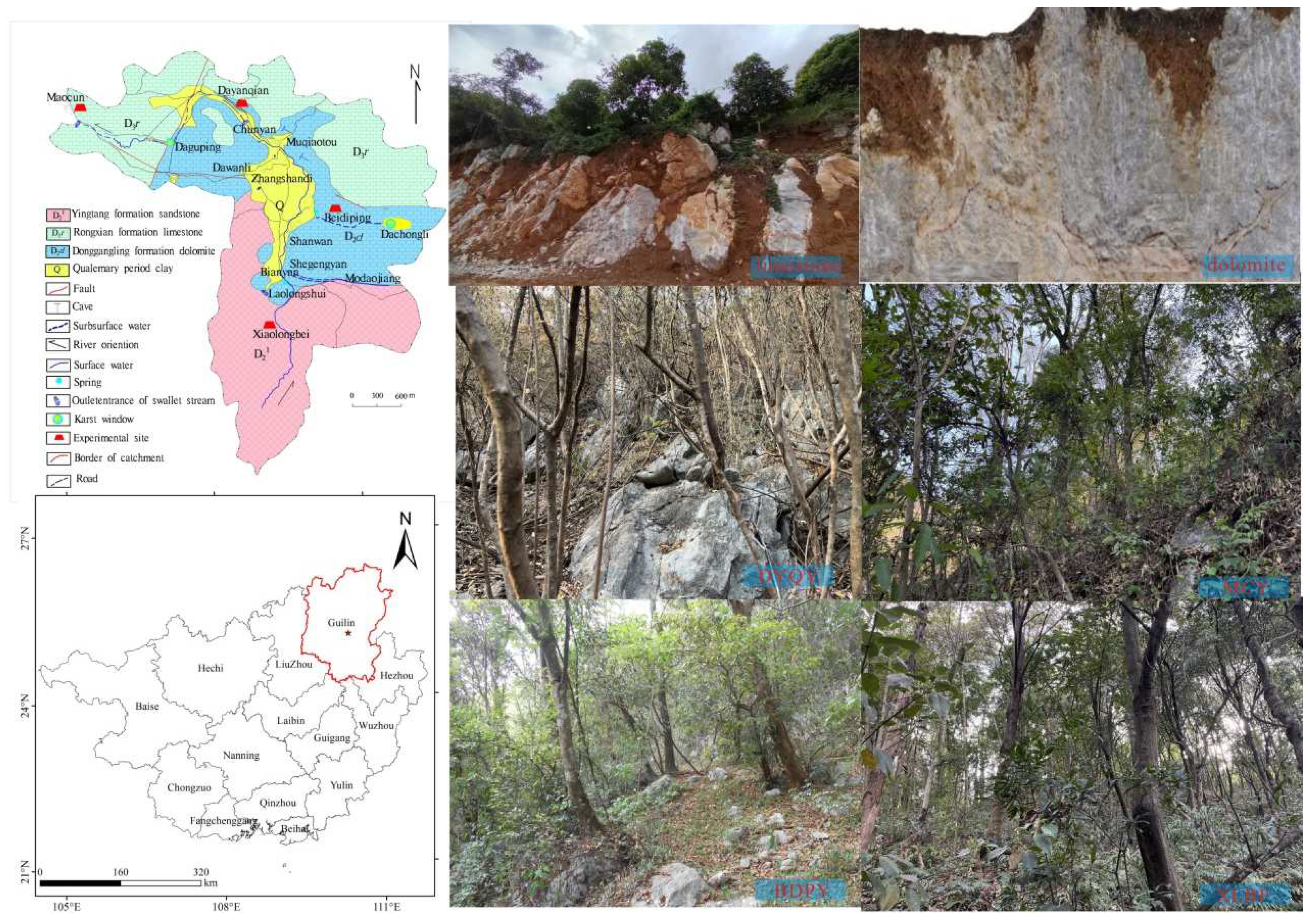
2.1. Study Site

The study area is located in Maocun, Chaotian Township, southeast of Guilin City, Guangxi (Figure 1) (110°30′00″~110°33′45″ E, 25°10′11″~25°12′30″ N), a typical karst crest depression and crest valley, with a total watershed area of about 10 km2. This region has a typical subtropical monsoon climate with an average annual temperature of 18.6 °C and annual precipitation of 1980 mm. The rainy season in the study area is from March to August, and the dry season is from September to February of the next year [35]. In 2021, rainfall was 1586.6 mm, and the average annual temperature was 21 °C in 2021. The elevation of the study area ranges from 150 to 350 m. The overall geological background in the basin includes a karst zone consisting of pure limestone of the Upper Devonian Rongxian Formation (D3r) and dolomite, limestone, and dolomitic tuff of the Middle Devonian Donggang Formation (D2d), and a clastic zone consisting of a set of Fe bearing sandstones of the lower Middle Devonian (D21). In this study, four sampling sites with different geological backgrounds were selected, namely Xiaolongbei (XLBF) in the clastic zone, Beidiping (BDPY) in the dolomite zone, Maocun (MCY) in the limestone zone, and Dayanqian (DYQY) in the dolomite zone. The monitoring sites in the limestone and dolomite areas of the karst area and in the clastic area were 1500 m apart and located in the same slope direction, with identical climatic conditions, and the only differentiating factors were geological background and soil type. The plant species in the karst sample sites were mainly Cyclobalanopsis glauca(Thunberg)Oersted, Loropetalum chinense(R.Br.) Oliver, and Murraya paniculata(L.) Jack; the plant species in the nonkarst sample sites were mainly Loropetalum chinense(R.Br.) Oliver, Machilus grijsii Hance, and Castanopsis hystrix J.D.Hooker (Table S1). In addition, the karst area mainly comprises limestone soil with a high clay and calcium content (Table S2); thus, the soil can be characterized as being sticky and heavy [36,37].

2.2. Sample Collection

Firstly, the dominant species in the study area were selected using the 20 m × 20 m quadrat method of investigation. The dominant species in the clastic rock area were mainly Castanopsis fargesii Franch, Castanopsis hystrix J.D.Hooker, and Machilus grijsii Hance; the dominant species in the dolomite area were mainly Loropetalum chinense(R.Br.) Oliver, Murraya paniculata(L.) Jack, and Osmanthus fragrans(Thunb.)Loureiro; and the dominant species in the limestone area were mainly Cyclobalanopsis glauca(Thunberg)Oersted, Miliusa philippensis(Lam.)Muell.Arg, and Miliusa balansae Finet Gagnep, as shown in Table 1. Three parallel samples of each plant species were collected and brought to the laboratory for low-temperature extraction, and then the extracted plant stem water was measured for deuterium (δD) and oxygen (δ18O) stable isotopes [13].
Soil samples from beneath the corresponding plants were taken from a depth of 100 cm and to avoid the samples being affected by other environmental factors, they were collected only after a week of rainfall. In the sampling process, the top layer of soil was stripped and sampled to minimize the effects of human disturbance. Soil was sampled at an interval of 10 cm on the profile, and a ring knife was taken every 10 cm for the determination of soil water content. In addition, further samples were taken in 8 mL glass sampling bottles, and three parallel samples were taken in each layer for the determination of δD and δ18O isotopes in soil water.
Rainfall samples were collected using standard rainfall barrels, and all single rainfall events exceeding 5 mm were sampled separately, with the collected samples stored in a refrigerator at 4 °C if they could not be tested promptly. Groundwater was also collected on the same day as the plant samples, and this was also stored in a refrigerator at 4 °C [9].
For this study, samples were collected from 29 November to 2 December 2021. A total of 78 plant samples, 444 soil samples, and 8 groundwater samples were collected, and 120 precipitation samples were collected throughout 2021.

2.3. Sample Determination

The moisture content of the collected soil was determined via the drying method (105 °C, 48 h). The calculation formula was [38]:
SWC % = Weight   of   fresh   soil Weight   of   soil   after   drying Weight   of   soil   after   drying × 100 %
Soil water and plant xylem water were extracted using a fully automatic vacuum condensation extraction system (Li-2100), and the extracted water was sealed in a 2 mL chromatography vial and stored in a refrigerator at 4 °C. The extracted soil water and plant water were analyzed for δD and δ18O using a EA-IRMS (Thermo Fisher MAT-253) mass spectrometer in the Karst Geology and Resource Environment Supervision and Testing Center of the Institute of Karst Geology, CAGS, and the standard mean ocean water (V-SMOW) standard was used for calibration of the experimental results. The analytical precision of δ18O and δD was not less than 0.2‰ and 1‰, respectively. Their hydrogen and oxygen isotope expressions were as follows:
δ = R sa R st 1 ×   1000  
Rsa: Ratio of isotopes in the sample (i.e., the ratio of 18O/16O or D/1H in the sample).
Rst: Ratio of isotopes in the standard (i.e., the ratio of 18O/16O or D/1H in V-SMOW).

2.4. Data Analysis

The direct comparison method and the multisource mixing model (IsoSource) [39] were used to analyze the sources of vegetation water under different lithological conditions. The IsoSource model was then used to quantitatively analyze the relative contribution of each water source to the different types of vegetation. The model was run with the increase and mass balance tolerance set to 1% and 0.1%, respectively, where the mass balance tolerance generally cannot be less than the product of the maximum difference between the source increment and the isotopic value of each potential water source [39].
The SW-Excess method proposed by Barbeta [40] et al. was used to evaluate the deviation based on plant xylem to soil water line:
SW excess = δ D a s δ 18 O b s
where as and bs are the slope and intercept of the soil water line at the same sampling site, respectively; δD and δ18O are the corresponding hydrogen and oxygen isotope values of the plant xylem water samples, respectively; SW-excess > 0 indicates that plant xylem water is more enriched in δD than soil water; and SW-excess < 0 indicates that plant xylem water is more depleted in δD than soil water.
Excel 2016 was used to organize and process the data, and Origin 2023 and ArcGIS 10.6 were used for graphing.

3. Results and Analysis

3.1. Variation Characteristics of δD and δ18O of Precipitation and Groundwater

The precipitation in the study area during 2021 was obtained from actual measured data from the Maocun meteorological station. The total precipitation in 2021 was 1586.6 mm, of which 1228.4 mm occurred in the rainy season, accounting for 77.4% of the annual rainfall, and 358.2 mm occurred in the dry season, accounting for 22.6% of the annual precipitation. There were obvious seasonal differences in the δD values of the precipitation, which generally showed enrichment in the dry season and depletion in the rainy season. From August onward, the δD values of precipitation were significantly enriched as precipitation decreased (Figure 2). The d-excess values in the study area ranged from 1.7‰ to 10.7‰ with a mean value of 6.6‰ in the rainy season, and from 4.6‰ to 47.2‰ with a mean value of 10.9‰ in the dry season. This shows that the d-values of atmospheric precipitation in the study area have more obvious fluctuations, and the mean d-values of water samples in the dry season exceed the global deuterium surplus (d = 10‰), whereas the mean d-values of water samples in the rainy season are smaller than the global deuterium surplus (d = 10‰).
The ranges of precipitation δD and δ18O were −79.1‰ to 42.0‰ and −11.6‰ to 5.1‰, respectively, and the Guilin precipitation line in 2021 was δD = 7.30δ18O + 7.74 (R2 = 0.94), where the slope and intercept were smaller than those of the global atmospheric precipitation line (δD = 8δ18O + 10) [41] and smaller than the slope and intercept of the atmospheric precipitation line (δD = 8.8δ18O + 17.96) in Guilin in 2012 (Figure 3) [42]. The groundwater δD and δ18O varied from −36.2‰ to −33.9‰ and −6.4‰ to −5.8‰, respectively, and their groundwater points were distributed close to the LMWL, which also proved that precipitation was an important source of groundwater recharge. The fitted curve (GWL) was δD = 5.27δ18O − 2.45 (R2 = 0.83), and its intercept and slope were lower than the LMWL.

3.2. Characteristics of Soil Water Variation in Karst and Nonkarst Areas

3.2.1. Variation in Soil Water Content with Depth

The variation in soil water content with soil depth under different vegetation types can be characterized as follows: the range of soil water content in the clastic zone (XLBF) was 19.7% to 31.2%; the range of soil water content in the dolomite zone (BDPY) was 17.9% to 28.8%; the range of soil water content in the limestone zone (MCY) was 23.9% to 32.4%; and the range of soil water content in the dolomite zone (DYQY) was 25.9% to 33.8% (Figure 4). With the exception of the clastic rock area, the water content of blank samples from areas without plant cover in the sample plots in other karst areas was significantly lower than that of samples from areas with plant cover. Overall, the variation in soil water content was broadly divided into three zones, with a large variation in water content in the shallow soil layer from 0 to 30 cm and a decreasing range of variation in the middle soil layer from 30 to 60 cm. The range of variation in soil water content in the 60–100 cm soil layer in the dolomite sample site (BDPY) decreased significantly, and the soil water content in the other sample sites increased significantly.

3.2.2. Characteristics of δD and δ18O Variation in Soil Water under Different Geologies

The δD and δ18O values of soil water from the three different bedrock sample sites are shown in Figure 5, and the fitted soil water lines are shown in Table 2. The slope and intercept of the soil water lines in the four sample sites were different. However, the slope and intercept of the SWL line in all four sample sites were smaller than those of the LMWL line, and the slope of the SWL line in the clastic rock sample site (XLBF) was the largest, with a slope value that was closest to that of the LMWL line. In addition, the plant stem water points in the sample plots were all to the lower right of the local precipitation line, and half of the plant stem water in the clastic rock area was distributed between the local precipitation line and the soil line. For the plant stem water collected from the dolomite sample site (BDPY), there was a phenomenon of depletion of individual plant stem water. Within this sample site, individual plant stem water points were on the upper left of the SWL line. With the exception of the dolomite sample site (BDPY), there was no obvious intersection point between the plant stem water points and the SWL or other potential water source lines in the karst area sample sites, and their plant stem water points were all on the lower right of the SWL line. In contrast, the plant stem water points in the clastic area were distributed on both sides of the SWL line.

3.3. Sources of Plant Water in Karst and Nonkarst Areas

3.3.1. Direct Correlation Method to Determine the Source of Plant Water Uptake

The source of plant water uptake can be determined more intuitively from the hydrogen and oxygen isotope values. As shown in Figure 6, when the plant stem water isotope is closest to the vertical line of each soil water curve as well as groundwater and rainfall, it is determined that the plant water source may come from that water source [43]. In this paper, we compared the distribution of δ18O values of the xylem of different plant species with the δ18O values of soil water and groundwater at different depths. The δ18O values of the four plant species in the clastic rock sample site were C.fargesii (a) (−4.8‰), C.hystrix(−5.4‰), M.grijsii (−5.0‰), and C.fargesii (b) (−5.4‰). Of these, the δ18O values of C.fargesii (b) and C.hystrix were close to those of the soil water at different depths. C.fargesii (b) mainly used the soil water below 70 cm; C.hystrix mainly used the soil water from 70 to 90 cm; and M.grijsii and C.fargesii (a) were closer to the soil water at 80 cm. The δ18O values of M.paniculata in the dolomite sample site intersected significantly with the δ18O values of soil water, whereas the other plants did not intersect significantly with the δ18O values of potential water sources. The δ18O values of the four plants in the limestone sample site were C. glauca (a) (−3.7‰), C.glauca (b) (−3.8‰), M.balansae (−4.3‰), and M.philippensis(−4.5‰), all of which were closer to the δ18O value of rainfall (−5.9‰), followed by the δ18O value of groundwater (−6.0‰), but none of the four plants intersected significantly with the δ18O value of potential water sources (Table S3).

3.3.2. Proportion of Plant Water Use

The contribution of different potential water sources to plant water varied, and there was significant variability in the water source profiles of different plant species as well as plants of the same type but with different stem diameters. The proportion of the contribution of different water sources to different plants was calculated using the IsoSource model (Figure 7). The plant water in the sample site in the clastic rock area was mainly derived from soil water, and the proportions of soil water utilized by the four different vegetation types Cf(a), Mg, Ch, and Cf(b) were 42%, 77%, 67%, and 46%, respectively. In the mixed forest of trees and shrubs, both trees and shrubs mainly used soil water and groundwater, and there was a relatively obvious competitive relationship between them. In the dolomite area, with the exception of the two shrubs that mainly used soil water, the proportions using mainly soil water and groundwater were 74% and 76%, respectively. The largest proportion of water sources for other plants was rainfall, with proportions of 87%, 73%, and 55%. With the exception of C. glauca (b) in the limestone zone sample plots, the largest proportion of water sources for other plants comprised groundwater, with proportions of 49%, 47%, and 69%, respectively, for all of the other plant species Cg(a), Mp, and Mb. Similarly, there was some competition between C. glauca (b) and M.philippensis in the mixed tree and irrigation forest, with groundwater contributing 31% and 47%, and rainfall contributing 25% and 23% to each, respectively. The sources of water found in the dolomite and limestone sample sites also verify our proposed hypothesis.

3.4. Variation in the SW-Excess of Plant Stem Water in Karst and Nonkarst Areas

There were large differences in the δD and δ18O values of xylem water in different lithologies (Table S4). The variation in δD and δ18O in the xylem water of the vegetation in the clastic zone (XLBF) ranged from −38.8‰ to −30.0‰ (mean −35.8‰) and from −5.9‰ to −4.5‰ (mean −5.2‰), respectively. The variation in the δD and δ18O values of the xylem moisture in the dolomite zone (BDPY) ranged from −44.6‰ to −31.3‰ (mean −36.7‰) and from −7.6‰ to −2.6‰ (mean −5.2‰), respectively. In the limestone zone (MCY), the vegetation xylem moisture δD and δ18O ranged from −46.6‰ to −33.4‰ (mean −40.0‰) and from −5.4‰ to −2.3‰ (mean −4.1‰), respectively. The variation in xylem moisture δD and δ18O in the dolomite zone (DYQY), where scrub is the main vegetation community, ranged from −44.4‰ to −39.4‰ (mean −42.0‰) and −5.0‰ to −3.1‰ (mean −4.1‰), respectively. The overall variation in plant xylem water in the clastic zone was smaller than that in the karst zone.
The mean values of SW-excess of plants in karst zones were all negative, and the mean values of SW-excess of plants in nonkarst zones were all positive (Figure 8). The mean values of SW-excess in the clastic zone (XLBF) ranged from −3.9‰ to 5.1‰ (mean 0.3‰). The mean values of SW-excess in the dolomite zone (BDPY) ranged from −11.7‰ to 4.6‰ (mean −0.9‰). The mean values of SW-excess ranged from −15.5‰ to −0.3‰ (average −6.0‰) in the limestone zone (MCY), and from −11.56‰ to −7.26‰ (average −9.3‰) in the dolomite zone (DYQY). In addition, groundwater was more enriched in δD than soil water, and the results suggested that the “two water worlds” hypothesis might hold true in the dry season in the dolomite and limestone sample sites, but not in the clastic area.

4. Discussion

4.1. Hydrogen and Oxygen Stable Isotope Characteristics and Their Influencing Factors

This study found that the δD values of rainfall differed significantly according to the season, with an overall expression of enrichment in the dry season and depletion in the rainy season, with the δD values of precipitation increasing significantly from August onward at the end of the rainy season with the decrease in rainfall. In addition, the slope and intercept of the local precipitation line were below the national atmospheric precipitation lines [34] as well as those of Guilin [35]. In addition, d-excess is a value related to evaporation, and generally a larger d value represents more intense evaporation in the area [44]. The results of this study showed that the d value in the dry season in the study area was much larger than the d value in the rainy season, which proved that the evaporation intensity was more intense in the dry season in the study area. Furthermore, low precipitation and dry soil in the dry season reduce the movement of water in the soil, and plants are thus more inclined to absorb the bound water in the soil, which indicates the possible existence of diagenetic waters in the karst area.
In this study, it was found that there was no obvious pattern of variation in soil water content according to soil depth in the study area, probably because multiple water sources interacted in the soil, making the relationship with soil water content complex. Overall, the variation in soil water content was broadly divided into three zones, with the shallow layer of soil from 0 to 30 cm being susceptible to external environmental influences and resulting in large variations in soil water content. The variation in soil water content in the middle layer of soil, from 30 to 60 cm, was significantly less, proving the existence of a certain water holding capacity in this layer [45]. The range of water content variation in the soil layer from 60 to 100 cm in the dolomite sample site (BDPY) decreased significantly, but in the other sample sites it increased significantly, proving that the soil from 60 to 100 cm may be influenced by the water table. Some studies have shown that when soil water is more abundant, trees generally use shallow soil water, and turn to deeper soil water only when the upper layer of soil is dry [46,47]. When studying the differences in root water absorption depth in a typical karst forest in the subtropics, Liu et al. [48] (2021) found that SWC varied significantly with the season, with an average of 41.4% in the abundant water period and 37.6% in the dry water period, and furthermore showed different variations according to soil depth. In the rainy season in particular, the fluctuation was most obvious in the soil layer from 0 to 30 cm, increasing with the depth of the soil layer, whereas the soil layer from 30 to 90 cm was relatively stable. In addition, in a study of degraded poplar, Liu et al. [49] (2021) found that the soil water content varied according to the degree of vegetation degradation and seasonal changes. They observed that the water content of soil from 0 to 120 cm was significantly affected by the season, but this was not the case for soil below 120 cm. Some studies have shown that, in addition to the degree of plant cover, different plant species also affect soil water content [50]. The water content of soil profiles with plant cover generally showed a fluctuating form of increase, and overall, the soil water content increased with soil depth, which may be due to the influence of water absorption by plant roots.
Because of the different rock types that form soil (soluble carbonate, dolomite, and limestone), soils have different water storage capacities, resulting in large variations in the water content of shallow soils in karst areas [51]. Compared with nonkarst areas, the water storage capacity of soil layers in karst areas is lower, and plants in karst areas must use other water sources in addition to soil water to maintain their normal water consumption [26,52]. In general, certain cation concentrations in the unsaturated soil matrix may cause isotopic effects, and when soils contain large amounts of carbonate [33,53], isotopic interactions between soil water and the carbonate system may lead to the fractionation of soil water [54,55]. For the “two water worlds” hypothesis (the term “ecohydrological separation”) [56], the effect occurs and may change, with changes occurring in the soil texture because pore size is important to determine whether or not there is matrix binding between water and soil particles [55]. Some studies show that in dry soils with a high clay content and high cation exchange capacity, clay particles interact with soil water to form a “pools” with different isotopes [30,54,57]. Another study showed that soil chemical properties may also contribute to isotopic segregation in soil water. The clay content is usually low in the mineral layer and very low in the organic layer, where cation exchange sites are located on organic material [30,54,57]. In addition, the soil water content will determine the magnitude of the δD deviation, whereas the δ18O deviation will determine the presence of carbonate.
The slope and intercept of the SWL line in all four sample sites in our study area were smaller than those of the LMWL line, indicating that soil water in the selected sample sites experienced stronger evapotranspiration. Half of the plant stem water in the clastic zone was distributed between the local precipitation line and the soil line, indicating that the evaporation and fractionation of plants in this area were not as strong as they were in the karst zone. Furthermore, the source of plant water in this area was also recharged via local precipitation and soil water. With the exception of the dolomite sample site (BDPY), there was no obvious intersection point between plant stem water points and the SWL and other potential water source lines in the karst area sample sites, and their plant stem water points were all to the lower right of the SWL line, and had more enriched δ18O values. Compared with nonkarst areas, the soil water storage capacity in karst areas is weak and water leakage is significant, with the result that plants in karst areas can only absorb karst water from the deeper layers [9]. The water source of plants in karst areas may provide evidence for the “two water worlds” hypothesis with regard to hydrological–ecological processes.

4.2. Factors Influencing the Source of Plant Water

Terrestrial plants generally do not undergo hydrogen and oxygen isotope fractionation [58], and δD and δ18O values in plant root and stem water are lower than those in soil water during upward transport of plant water [59], whereas δD and δ18O values of plants in this study were significantly higher than those in the soil and soil water. This indicates that strong evapotranspiration in the study area has led to more severe fractionation of stem water in the area, causing the lighter δD and δ18O in the plant stem water to evaporate, leaving behind the heavier δD and δ18O. Soil–rock interlocking in the surface zone of the karst area facilitates convergence of the surface soil and water in the system of fissures and subsurface pores of the rock body [60]. The filling of soil has contributed to the fact that the shallow fissures in karst areas are no longer just the main channels for subsurface leakage, but have also become the main soil-supporting spaces in karst areas [61,62]. Plant roots grow and develop in these fissure spaces, and the soil filling can, to a certain extent, retard water infiltration and provide the moisture needed for vegetation growth, which further influences the type of aboveground vegetation. It has been shown that changes in the δD and δ18O values of plant tissues are related to the fractionation of hydrogen and oxygen isotopes during vegetation metabolism [63]. Different types of vegetation use water in different ways. In their study, Josep et al. [64] (2000) selected several major plants in desert subsistence areas of Spain and found that the way in which different plant species use water is dependent on the distribution of the different plant root systems of trees, shrubs, and herbaceous plants. Additionally, it was found that plant use of each potential water source could be quantified according to the different hydrogen and oxygen isotope values of the water source [65]. Valentini et al. [66] (1992) found that evergreen Mediterranean tree species mainly used precipitation, whereas deciduous tree species used groundwater.
In addition to the vegetation type affecting its use of water sources, different geological contexts also affect the dominant vegetation type. In this study, the isotopes of water in the xylem of all four plant species in the dolomite region (BDPY) were close to the groundwater isotope values, which in turn were close to the rainwater isotope values of recent rainfall (November), so the main source of water for the vegetation could be groundwater or recent rainwater stored in rock fractures. To further verify the plant water sources, the proportion of vegetation water sources was calculated using the IsoSource model. This ruled out the possibility of groundwater as the main water source and showed that plants in the tree category mainly used a mixture of recent and previous rainfall. Although shallow fissures in karst areas can store a certain amount of rainwater, the competition for the use of shallow fissure water varies because of limited water storage and different plants, and tree species can absorb water through the fissures because their root systems can move up through the rocks [27]. This is the reason for the large difference in water use between trees and shrubs in the dolomite sample site. The isotopes of water in the xylem of all four plant species in the limestone areas were close to the groundwater isotope values, and in contrast to the dolomite areas, the proportion of vegetation water sources calculated using the IsoSource model revealed that groundwater was the main source of vegetation water. The main reason for this is that the fractures and water storage capacity in limestone are much higher than those in dolomite areas [9,15]. In an analysis of plant water sources under different types of restoration in limestone areas of Yunnan conducted by Hu et al. [67] (2021), it was found that the δ18O values of Yunnan cycad stem water in the dry season were closer to those of karst groundwater and middle soil water. This was very similar to the results from the limestone areas in our study, where C. glauca (a) and C. glauca (b) were mainly dominated by groundwater and soil water, but the utilization of groundwater and the proportion using groundwater and soil water also differed, with the young C. glauca using mainly soil water and the mature C. glauca using groundwater because of their dense root systems.
Possible reasons for the difference in plant water sources between the sample sites in the dolomite and limestone zones, with the former being dominated by rainfall and the latter by groundwater, are related to the bedrock of the sample sites. It has been shown that the depth of the water table in limestone outcrops has a lagging effect on the response to rainfall [13]. Nie et al. [25] (2011) investigated dolomite outcrop bedrock and found that shrublands in the study area mainly used rainwater stored in fissures during the rainy season, whereas in the dry season, they mainly used water in the saturated zone. This differs from the results of our study, which found that shrub thickets in the dolomite sample sites were dominated by soil water, whereas trees were dominated by rainfall. In their study of plant water sources in highland karst areas, McCole et al. [68] (2007) found that Juniperusashei was dominated by groundwater during the dry season. In addition, different types of weathered bedrock have different water storage capacities, which are closely related to the degree of weathering and condition of the fissures, whereas the bedrock in dolomite areas is mainly weathered as a whole mass, and fissures are not as abundant as they are in limestone weathered bedrock [9]. Plants in the limestone sample site are more likely to root into the weathered bedrock than in the dolomite sample site, which is one of the reasons for the difference in use of potential water sources in the two sample sites. Thus, bedrock is an important factor controlling the source of plant water.

5. Conclusions

The measurement of hydrogen–oxygen stable isotope combined with the IsoSource model revealed obvious differences in the water use patterns of plants under different bedrock conditions. The results of this study confirm our previous hypothesis that bedrock is an important factor affecting the source of vegetation water. Specifically, plants in the clastic zone were dominated by soil water. In the dolomite zone, with the exception of shrub forests, which are mainly dominated by soil water, all other plant water sources were dominated by rainfall. In the limestone zone, with the exception of some individual plants, all other plant water sources were dominated by groundwater. Meanwhile, this study also found that there may be an ecological–hydrological separation phenomenon in karst areas, i.e., the existence of the “two water worlds” hypothesis by SW-excess fluctuation range. These findings can contribute to improving ecological restoration in areas of karst rocky desertification.

Supplementary Materials

The following supporting information can be downloaded at: https://www.mdpi.com/article/10.3390/land12010012/s1, Table S1: The dominant species at the sampling site; Table S2: Physical and chemical characteristics of soil; Table S3: The variation in stem water δ18O; Table S4: Variation characteristics of SW-excess of plants.

Author Contributions

Conceptualization, H.Y., and J.C.; data curation, J.N., X.L., and J.M.; methodology, J.N., X.W., and H.Y.; validation, H.Y., J.C., and J.N.; visualization, J.N., and X.L.; writing—original draft, J.N.; writing—review and editing, H.Y., J.C., X.W., and J.N. All authors have read and agreed to the published version of the manuscript.

Funding

This work was supported by the National Key Research and Development Program of China under grant no. 2021YFE0107100, the Guangxi Key Research and Development Program under grant no. GuikeAB22035004, the Guangxi Science and Technology Base and Talent Special Project under grant no. Guike AD20297090, and the Guilin Key Research and Development Program of China under grant no. 2020010403.

Institutional Review Board Statement

Not applicable.

Informed Consent Statement

Not applicable.

Data Availability Statement

The data that support the findings of this study are available on request from the corresponding author.

Acknowledgments

This work was supported by the National Key Research and Development Program of China under grant no. 2021YFE0107100, the Guangxi Key Research and Development Program under grant no. GuikeAB22035004, the Guangxi Science and Technology Base and Talent Special Project under grant no. Guike AD20297090, and the Guilin Key Research and Development Program of China under grant no. 2020010403. Special thanks to the anonymous referees for their valuable comments and suggestions. Thanks also to Fen Huang and Chunlai Zhang for their help with field work.

Conflicts of Interest

The authors declare no conflict of interest.

References

  1. Zeng, X.M.; Xu, X.L.; Zhong, F.X.; Yi, R.Z.; Xu, C.W.; Zhang, Y.H. Comparative study of MixSIAR and IsoSource models in the analysis of plant water sources. Acta Ecol. Sin. 2020, 40, 5611–5619. (In Chinese) [Google Scholar]
  2. Pauses, J.G.; Austin, M.P. Patterns of plant species richness in relation to different environments: An appraisal. J. Veg. Sci. 2001, 12, 153–166. [Google Scholar] [CrossRef]
  3. Khadka, M.B.; Martin, J.B.; Kurz, M.J. Synoptic estimates of diffuse groundwater seepage to a spring-fed karst river at high spatial resolution using an automated radon measurement technique. J. Hydrol. 2016, 544, 86–96. [Google Scholar] [CrossRef] [Green Version]
  4. Wu, C.; Jiang, Y.J.; Shen, L.C.; Liu, J.C.; He, R.L. Response of water use efficiency of typical plants to tunnel construction in karst trough valley. Acta Ecol. Sin. 2020, 40, 4032–4040. (In Chinese) [Google Scholar]
  5. Gunn, J. Point-recharge of limestone aquifers-a model from new zealand karst. J. Hydrol. 1983, 61, 19–29. [Google Scholar] [CrossRef]
  6. Trcek, B. How can the epikarst zone influence the karst aquifer hydraulic behaviour? Environ. Geol. 2007, 51, 761–765. [Google Scholar] [CrossRef]
  7. Yuan, D.X.; Jiang, R.J.; Shen, L.C.; Pu, J.B.; Xiao, C. Modern Karstololgy; Science Press: Beijing, China, 2016; pp. 292–316. (In Chinese) [Google Scholar]
  8. Jiang, Z.C. Features of epikarst zone in south China and formation mechanism. Trop. Geogr. 1998, 18, 322–326. (In Chinese) [Google Scholar]
  9. Nie, Y.P.; Chen, H.S.; Wang, K.L. Seasonal variation of water sources for plants growing on continuous rock outcrops in limestone area of Southwest China. Chin. J. Plant Ecol. 2011, 35, 1029–1037. (In Chinese) [Google Scholar]
  10. Nie, Y.P.; Chen, H.S.; Wang, K.L.; Yang, J. Water source utilization by woody plants growing on dolomite outcrops and nearby soils during dry seasons in karst region of Southwest China. J. Hydrol. 2012, 420–421, 264–274. [Google Scholar] [CrossRef]
  11. Zhang, X.; Xiao, Y.; Wan, H.; Deng, Z.M.; Pan, G.Y.; Xia, J. Using stable hydrogen and oxygen isotopes to study water movement in soil-plant-atmos-phere continuum at Lake Poyang wetland China. Wetl. Ecol. Manag. 2017, 25, 221–234. [Google Scholar] [CrossRef]
  12. Liu, J.C.; Shen, L.C.; Wang, Z.X.; Duan, S.H.; Wu, W.; Peng, X.Y.; Wu, C.; Jiang, Y.J. Response of plants water uptake patterns to tunnels excavation based on stable isotopes in a karst trough valley. J. Hydrol. 2019, 571, 485–493. [Google Scholar] [CrossRef]
  13. Deng, Y.; Ke, J.; Wu, S.; Jiang, G.H.; Jiang, Z.C.; Zhu, A.J. Responses of plant water uptake to groundwater depth in limestone outcrops. J. Hydrol. 2020, 590, 125377. [Google Scholar] [CrossRef]
  14. Wu, Z.; Behzad, H.M.; He, Q.F.; Wu, Y.B.; Jiang, Y.J. Seasonal transpiration dynamics of evergreen Ligustrum lucidum linked with water source and water-use strategy in a limestone karst area, Southwest China. J. Hydrol. 2021, 597, 126199. [Google Scholar] [CrossRef]
  15. Liu, H.Y.; Jiang, Z.H.; Dai, J.Y.; Wu, X.C.; Peng, J.; Wang, H.Y.; Meersmans, J.; Green, S.M.; Quine, T.A. Rock crevices determine woody and herbaceous plant cover in the karst critical zone. Sci. China Earth Sci. 2019, 49, 8. (In Chinese) [Google Scholar] [CrossRef]
  16. Chen, H.S.; Hu, K.; Nie, Y.P.; Wang, K.L. Analysis of soil water movement inside a footslope and a depression in a karst catchment, Southwest China. Sci. Rep. 2017, 7, 2544. [Google Scholar] [CrossRef] [Green Version]
  17. Luo, Z.D.; Guan, H.D.; Zhang, X.P.; Xu, X.; Dai, J.J.; Hua, M.Q. Examination of the ecohydrological separation hypothesis in a humid subtropical area: Comparison of three methods. J. Hydrol. 2019, 571, 642–650. [Google Scholar] [CrossRef] [Green Version]
  18. Matthias, S.; Doerthe, T.; Chris, S. No influence of CO2 on stable isotope analyses of soil waters with off-axis integrated cavity output spectroscopy. Rapid Commun. Mass Spectrom. 2017, 21, 430–436. [Google Scholar]
  19. Diner, T.; Davis, G.H. Application of environmental isotope tracers to modeling in hydrology. J. Hydrol. 1984, 68, 95–113. [Google Scholar] [CrossRef]
  20. Deng, Y.; Jiang, Z.C.; Qin, X.M. Water source partitioning among trees growing on carbonate rock in a subtropical region of Guangxi, China. Environ. Earth Sci. 2012, 66, 635–640. [Google Scholar] [CrossRef]
  21. Dai, J.J.; Zhang, X.P.; Luo, Z.D.; Wang, R.; Liu, Z.L.; He, X.G.; Rao, Z.G.; Guan, H.D. Variation of the stable isotopes of water in the soil-plant-atmosphere continuum of a Cinnamomum camphora woodland in the East Asian monsoon region. J. Hydrol. 2020, 589, 125199–125210. [Google Scholar] [CrossRef]
  22. Brunel, J.P.; Walker, G.R.; Kennett-Smith, A.K. Field validation of isotopic procedures for determining sources of water used by plants in a semi-arid environment. J. Hydrol. 1995, 167, 351–368. [Google Scholar] [CrossRef]
  23. Asbjornsen, H.; Shepherd, G.; Helmers, M.; Mora, G. Seasonal patterns in depth of water uptake under contrasting annual and perennial systems in the Corn Belt Region of the Midwestern US. Plant Soil 2008, 308, 69–92. [Google Scholar] [CrossRef]
  24. Li, S.G.; Tsujimura, M.; Sugimoto, A.; Sasaki, L.; Yamanaka, T.; Davaa, G.; Oyunbaatar, D.; Sugita, M. Seasonal variation in oxygen isotope composition of waters for a montane larch forest in Mongolia. Trees 2006, 20, 122–130. [Google Scholar] [CrossRef]
  25. Nie, Y.P.; Chen, H.S.; Wang, K.L.; Tan, W.; Deng, P.Y.; Yang, J. Seasonal water use patterns of woody species growing on the continuous dolostone outcrops and nearby thin soils in subtropical China. Plant Soil 2011, 341, 399–412. [Google Scholar] [CrossRef]
  26. Nie, Y.P.; Chen, H.S.; Ding, Y.L.; Yang, J.; Wang, K.L. Comparison of rooting strategies to explore rock fractures for shallow soil-adapted tree species with contrasting aboveground growth rates: A greenhouse microcosm experiment. Front. Plant Sci. 2017, 8, 1651–1662. [Google Scholar] [CrossRef]
  27. Zhu, X.Q.; Fan, Y.; Guan, W.; Tan, N. Soil-water utilization levels in a Cyclobalanopsis glaucoides virgin forest on the Central Yunnan Karst Plateau. J. Zhejiang A F Univ. 2014, 31, 690–696. (In Chinese) [Google Scholar]
  28. Li, J.P.; Liu, W.J.; Wang, P.Y.; Li, J.T. Plant Water Use Strategies in a Limestone Tropical Seasonal Moist Rainforest in Xishuangbanna, SW China. Acta Bot. Yunnanica 2008, 30, 496–504. (In Chinese) [Google Scholar] [CrossRef]
  29. Brooks, J.R.; Barnard, H.R.; Coulombe, R.; McDonnell, J.J. Ecohydrologic separation of water between trees and streams in a Mediterranean climate. Nat. Geosci. 2010, 3, 100–104. [Google Scholar] [CrossRef]
  30. Araguás-Araguás, L.; Rozanski, K.; Gonfiantini, R.; Louvat, D. Isotope effects accompanying vacuum extraction of soil water for stable isotope analyses. J. Hydrol. 1995, 168, 159–171. [Google Scholar] [CrossRef]
  31. Coplen, T.B.; Hanshaw, B.B. Ultrafiltration by a compacted clay membrane—I. Oxygen and hydrogen isotopic fractionation. Geochim. Cosmochim. Acta 1973, 37, 2295–2310. [Google Scholar] [CrossRef]
  32. Oerter, E.; Finstad, K.; Schaefer, J.; Goldsmith, G.R.; Dawson, T.; Amundson, R. Oxygen isotope fractionation effects in soil water via interaction with cations (Mg, Ca, K, Na) adsorbed to phyllosilicate clay minerals. J. Hydrol. 2014, 515, 1–9. [Google Scholar] [CrossRef]
  33. Vargas, A.; Schaffer, B.; Yuhong, L.; Sternberg, L.D.S.L. Testing plant use of mobile vs immobile soil water sources using stable isotope experiments. New Phytol. 2017, 215, 582–594. [Google Scholar] [CrossRef] [Green Version]
  34. Jiang, N.N.; Wang, Z.C.; Ma, X.Y.; Liu, W.N.; Chen, H.S.; Nie, Y.P. Isotopic deviations of water extracted from carbonate soil by cryogenic vacuum extraction: Implication for root water uptake analysis. Plant Soil 2022, 475, 79–89. [Google Scholar] [CrossRef]
  35. Guo, X.J.; Jiang, G.H.; Gong, X.P.; Yin, J.J.; Wu, X. Recharge processes on typical karst slopes implied by isotopic and hydrochemical indexes in Xiaoyan Cave, Guilin, China. J. Hydrol. 2015, 530, 612–622. [Google Scholar] [CrossRef]
  36. Zhu, T.B.; Zeng, S.M.; Qin, H.L.; Zhou, K.X.; Yang, H.; Lan, F.; Huang, F.; Cao, J.H.; Müller, C. Low nitrate retention capacity in calcareous soil under woodland in the karst region of southwestern China. Soil Biol. Biochem. 2016, 97, 99–101. [Google Scholar] [CrossRef]
  37. Yang, H.; Garousi, F.; Wang, J.; Cao, J.H.; Xu, X.L.; Zhu, T.B.; Mueller, C. Land use effects on gross soil nitrogen transformations in karst desertification area. Plant Soil 2022, 475, 61–77. [Google Scholar] [CrossRef]
  38. Su, P.Y.; Zhang, M.J.; Qu, D.Y.; Wang, J.X.; Zhang, Y.; Yao, X.Y.; Xiao, H.T. Contrasting water use strategies of Tamarix ramosissima in different habitats in the northwest of Loess Plateau, China. Water 2020, 12, 2791. [Google Scholar] [CrossRef]
  39. Phillips, D.L.; Gregg, J.W. Source partitioning using stable isotopes: Coping with too many sources. Oecologia 2003, 136, 261–269. [Google Scholar] [CrossRef]
  40. Barbeta, A.; Jones, S.P.; Clavé, L.; Wingate, L.; Gimeno, T.E.; Fréjaville, B.; Wohl, S.; Ogée, J. Unexplained hydrogen isotope offsets complicate the identification and quantification of tree water sources in a riparian forest. Hydrol. Earth Syst. Sci. 2019, 23, 2129–2146. [Google Scholar] [CrossRef] [Green Version]
  41. Graig, H. Isotopic variations in meteoric waters. Science 1961, 133, 1702–1703. [Google Scholar]
  42. Zhu, X.Y.; Zhang, M.L.; Wu, X.; Pan, M.C. The relationship between δ18O characteristics of the precipitation (heavy rainfall or rainstorm) and its water vapor sources in Guilin, China. Carsologica Sin. 2017, 36, 139–161. (In Chinese) [Google Scholar]
  43. Yang, B.; Wen, X.; Sun, X. Seasonal variations in depth of water uptake for a subtropical coniferous plantation subjected to drought in an East Asian monsoon region. Agric. For. Meteorol. 2015, 201, 218–228. [Google Scholar] [CrossRef]
  44. Dansguaard, W. Stable isotopes in precipitation. Tell Us 1964, 16, 436–468. [Google Scholar] [CrossRef]
  45. Long, X.; Sun, Z.Y.; Zhou, A.G.; Yu, S.W.; Cao, H. Using 18O stable isotopes to trace the water sources of riparian Tamarix in middle reaches of Heihe River. J. Arid. Land Resour. Environ. 2014, 28, 150–155. (In Chinese) [Google Scholar]
  46. Dai, Y.; Zheng, X.J.; Tang, L.S.; Li, Y. Stable oxygen isotopes reveal distinct water use patterns of two Haloxylon species in the Gurbantonggut Desert. Plant Soil 2015, 389, 73–87. [Google Scholar] [CrossRef]
  47. Liu, Z.Q.; Yu, X.X.; Jia, G.D.; Jia, J.B.; Lou, Y.H.; Lu, W.W. Contrasting water sources of evergreen and deciduous tree species in rocky mountain area of Beijing, China. Catena 2017, 150, 108–115. [Google Scholar] [CrossRef]
  48. Liu, W.N.; Chen, H.S.; Zou, Q.Y.; Nie, Y.P. Divergent root water uptake depth and coordinated hydraulic traits among typical karst plantations of subtropical China: Implication for plant water adaptation under precipitation changes. Agric. Water Manag. 2021, 249, 106798. [Google Scholar] [CrossRef]
  49. Liu, Z.A.; Jia, G.D.; Yu, X.X.; Liu, W.W.; Sun, L.B.; Wang, Y.S.; Baheti, Z. Morphological trait as a determining factor for Populus simonii Carr. to survive from drought in semi-arid region. Agric. Water Manag. 2021, 253, 106943. [Google Scholar]
  50. Wang, J.; Lu, N.; Fu, B.J. Inter-comparison of stable isotope mixing models for determining plant water source partitioning. Sci. Total Environ. 2019, 666, 685–693. [Google Scholar] [CrossRef]
  51. Yang, J.; Chen, H.S.; Nie, Y.P.; Wang, K.L. Dynamic variations in profile soil water on karst hillslopes in Southwest China. Catena 2019, 172, 655–663. [Google Scholar] [CrossRef]
  52. Jackson, R.B.; Moore, L.A.; Hoffmann, W.A.; Pockman, W.T.; Linder, C.R. Ecosystem rooting depth determined with caves and DNA. Proc. Natl. Acad. Sci. USA 1999, 96, 11387–11392. [Google Scholar] [CrossRef] [Green Version]
  53. Oshun, J.; Dietrich, W.E.; Dawson, T.E.; Fung, I. Dynamic, structured heterogeneity of water isotopes inside hillslopes. Water Resour. Res. 2016, 52, 164–189. [Google Scholar] [CrossRef] [Green Version]
  54. Meißner, M.; Köhler, M.; Schwendenmann, L.; Hölscher, D.; Dyckmans, J. Soil water uptake by trees using water stable isotopes (δ2H andδ18O)-a method test regarding soil moisture, texture and carbonate. Plant Soil 2014, 376, 327–335. [Google Scholar] [CrossRef]
  55. Bowling, D.R.; Schulze, E.S.; Hall, S.J. Revisiting streamside trees that do not use stream water: Can the two water worlds hypothesis and snowpack isotopic effects explain a missing water source? Ecohydrology 2017, 10, e1771. [Google Scholar] [CrossRef] [Green Version]
  56. McDonnell, J.J. The two water worlds hypothesis: Ecohydrological separation of water between streams and trees? WIREs Water 2014, 1, 323–329. [Google Scholar] [CrossRef]
  57. Geris, J.; Tetzlaff, D.; Mcdonnell, J.; Anderson, J.; Paton, G.; Soulsby, C. Ecohydrological separation in wet, low energy northern environments? A preliminary assessment using different soil water extraction techniques. Hydrol. Process. 2015, 29, 5139–5152. [Google Scholar] [CrossRef] [Green Version]
  58. Thorburn, P.J.; Hatton, T.J.; Walker, G.R. Combining measurements of transpiration and stable isotopes of water to determine groundwater discharge from forests. J. Hydrol. 1993, 150, 563–587. [Google Scholar] [CrossRef]
  59. Lin, G.H.; Sternberg, L.S.L. Hydrogen isotopic fractionation by plant roots during water uptake in coastal wetland plants. In Stable Isotopes and Plant Carbon/Water Relations; Ehleringer, J.R., Hall, A.E., Eds.; Academic Press: New York, NY, USA, 1993; pp. 497–510. [Google Scholar]
  60. Cao, J.H.; Yuan, D.X.; Pan, G.X. Soil in karst ecosystem. Adv. Earth Sci. 2003, 18, 37–44. (In Chinese) [Google Scholar]
  61. Li, S.; Wu, H. Mapping karst rocky desertification using Landsat 8 images. Remote Sens. Lett. 2015, 6, 657–666. [Google Scholar] [CrossRef]
  62. Zhu, X.A.; Shen, Y.X.; He, B.B.; Zhao, Z.M. Humus soil as a critical driver of flora conversion on karst rock outcrops. Sci. Rep. 2017, 7, 12611. [Google Scholar] [CrossRef] [Green Version]
  63. Nagy, K.A. Doubly-Labeled Water Studies of Vertebrate Physiological Ecology. Stable Isot. Ecol. Res. 1989, 68, 270–287. [Google Scholar]
  64. Josep, P.; Iolanda, F.; Jaume, T. Variability of plant nitrogen and water use in a 100-m transect of a subdesertic depression of the Ebro valley (Spain) characterized by leaf δ13C and δ15N. Acta Oecologica 1999, 20, 119–123. [Google Scholar]
  65. Yakir, D.; Sternberg, Y.L. The Use of Stable Isotopes to Study Ecosystem Gas Exchange. Oecologia 2000, 123, 297–311. [Google Scholar] [CrossRef] [PubMed]
  66. Valentini, R.; Anfodillo, T.; Eeleringer, J.R. Water sources and carbon isotope composition (δ13 C) of selected tree species of the Italian Alps. Can. J. For. Res. 1994, 24, 1575–1578. [Google Scholar] [CrossRef]
  67. Hu, H.H.; Chen, J.H.; Mou, Y.; Fang, W.; Kuang, Y.Y.; Fan, Y. Differences of Water Use Strategies of Pinus yunnanensis in Different Recovery Modes in Karst Mountains in Southeast Yunnan. J. Northwest For. Univ. 2021, 36, 37–44. (In Chinese) [Google Scholar]
  68. McCole, A.A.; Stern, L.A. Seasonal water use patterns of Juniperus ashei on the Edwards Plateau, Texas, based on stable isotopes in water. J. Hydrol. 2007, 342, 238–248. [Google Scholar] [CrossRef]
Figure 1. Study area location and panorama.
Land 12 00012 g001
Figure 2. Precipitation distribution and seasonal variation in deuterium surplus in the study area.
Land 12 00012 g002
Figure 3. Plots of δD and δ18O in precipitation and groundwater. GMWL is the global meteoric water line (δD = 8δ18O + 10) [34,41], LMWL represents the local meteoric water line, and GWL represents groundwater.
Land 12 00012 g003
Figure 4. Relationship between soil profile moisture contents and depth (1-1 tree forest, 1-2 tree and shrub forest, 1-3 scrub, 1-4 bare land; 2-1 tree forest, 2-2 tree and shrub forest, 2-3 tree forest, 2-4 bare land; 3-1 tree forest, 3-2 tree and shrub forest, 3-3 scrub forest, 3-4 bare land, 4-1 scrub forest, 4-2 bare land).
Land 12 00012 g004
Figure 5. Local meteoric water line and distribution characteristics of δ18O and δD in different water bodies at four sampling points in the study area.
Land 12 00012 g005
Figure 6. The variation in stem water and soil water δ18O.
Land 12 00012 g006
Figure 7. Stem water source proportion results from the IsoSource model.
Land 12 00012 g007
Figure 8. Variation characteristics of SW-excess of plants in the study area.
Land 12 00012 g008
Table 1. Sampling site information.
Sampling SiteSampling PointsVegetation CategoryAdvantageous Species
Clastic rock (XLBF)1-1tree forestCastanopsis fargesii Franch
1-2tree and shrub forestMachilus grijsii Hance, Castanopsis hystrix J.D.Hooker
1-3scrubCastanopsis fargesii Franch
1-4bare land
Dolomite (BDPY)2-1tree forestLoropetalum chinense(R.Br.) Oliver
2-2tree and shrub forestLoropetalum chinense(R.Br.) Oliver, Murraya paniculata(L.) Jack
2-3tree forestOsmanthus fragrans(Thunb.)Loureiro
2-4bare land
Limestone (MCY)3-1tree forestCyclobalanopsis glauca(Thunberg)Oersted
3-2tree and shrub forestCyclobalanopsis glauca(Thunberg)Oersted, Miliusa philippensis(Lam.)Muell.Arg
3-3scrubMiliusa balansae Finet Gagnep
3-4bare land
Dolomite (DYQY)4-1scrubLoropetalum chinense(R.Br.) Oliver
4-2bare land
Table 2. Equations for soil water line in sampling sites.
Sampling SiteδDδ18OSoil Water Lines (SWL)
Clastic rock (XLBF)−53.5‰~−30.0‰ (average −41.8‰)−7.8‰~−4.3‰ (average −6.1‰)δD = 6.17δ18O − 4.30 (R2 = 0.85)
Dolomite (BDPY)−55.0‰~−40.1‰ (average −48.1‰)−8.7‰~−6.2‰ (average −7.4‰)δD = 5.68δ18O − 6.89 (R2 = 0.82)
Limestone (MCY)−60.4‰~−42.2‰ (average −52.8‰)−9.7‰~−5.3‰ (average −8.0‰)δD = 4.76δ18O − 14.74 (R2 = 0.84)
Dolomite (DYQY)−51.4‰~−39.4‰ (average −46.0‰)−7.9‰~−5.4‰ (average −6.7‰)δD = 5.08δ18O − 11.94 (R2 = 0.87)
Disclaimer/Publisher’s Note: The statements, opinions and data contained in all publications are solely those of the individual author(s) and contributor(s) and not of MDPI and/or the editor(s). MDPI and/or the editor(s) disclaim responsibility for any injury to people or property resulting from any ideas, methods, instructions or products referred to in the content.

