Modeling and Assessment of Land Degradation Vulnerability in Arid Ecosystem of Rajasthan Using Analytical Hierarchy Process and Geospatial Techniques
Abstract
1. Introduction
2. Materials and Methods
2.1. Study Area
2.2. Data Acquisition
2.3. Data Processing
2.3.1. Terrain Parameters
2.3.2. Climatic Parameters
2.3.3. Vegetation Parameters
2.3.4. Soil Parameters
2.4. Analytical Hierarchical Process and Weightage Assignment
2.5. Generating Land Degradation Vulnerability Map
3. Result
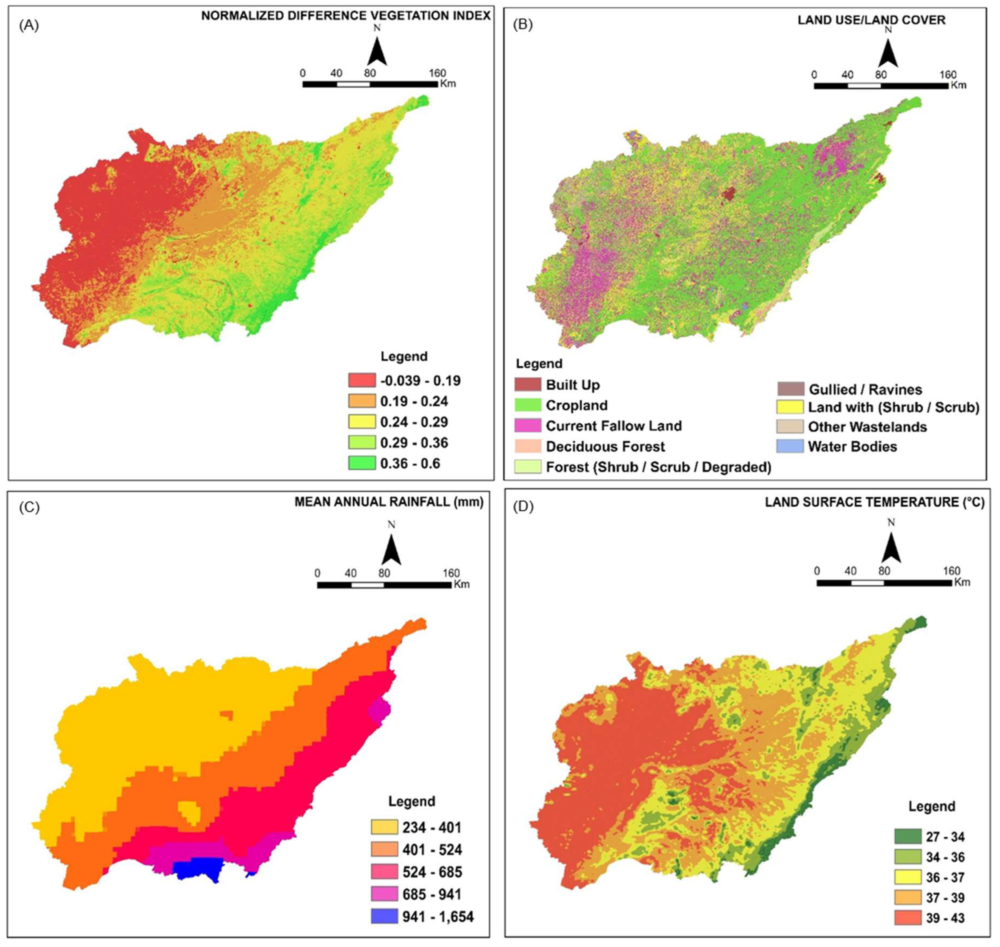
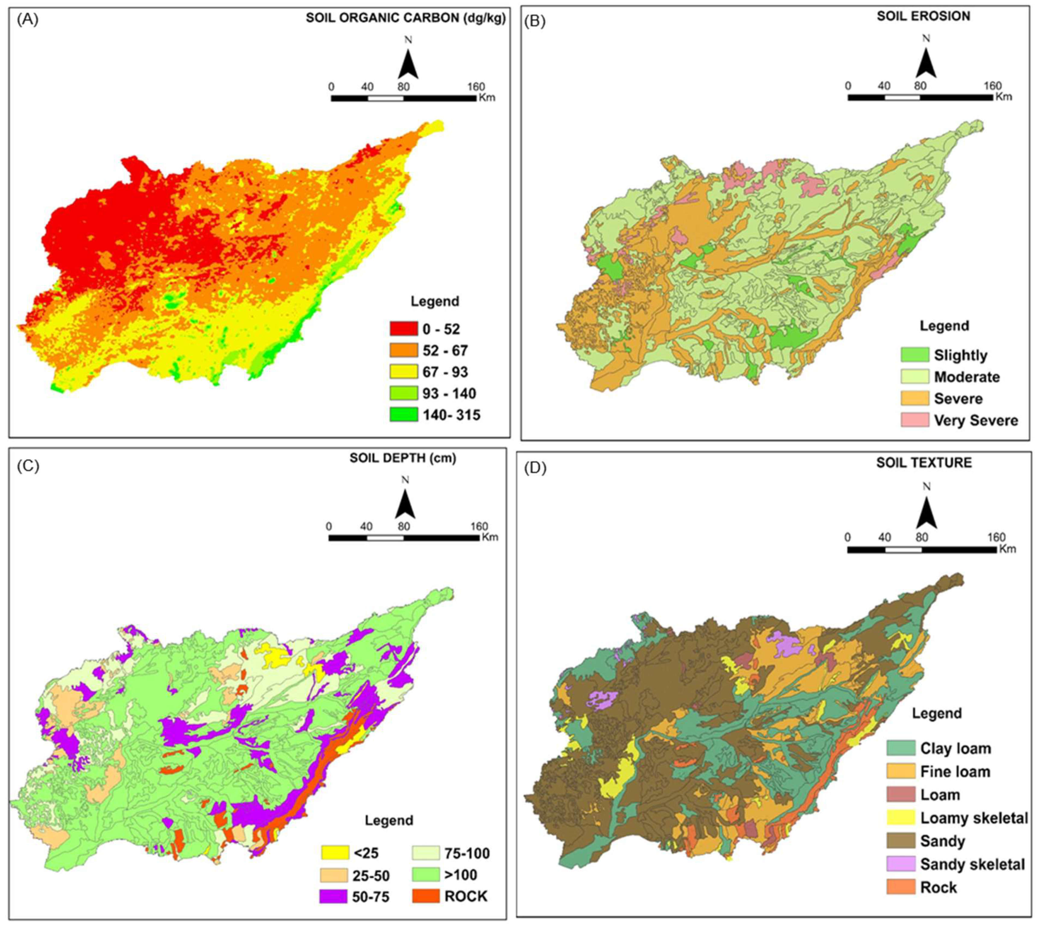
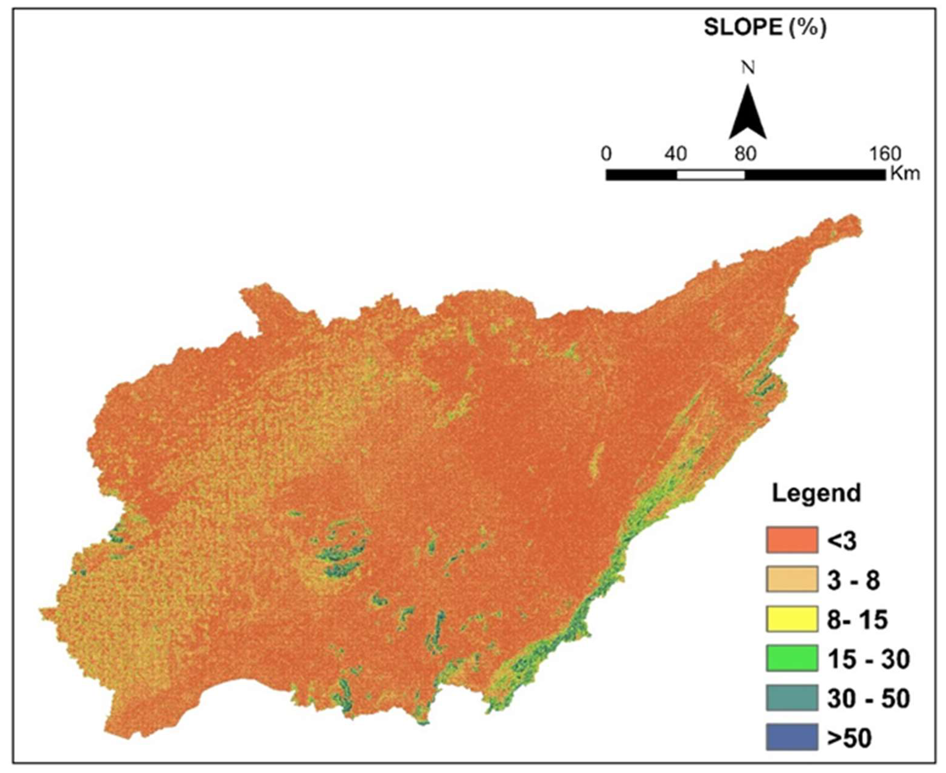
3.1. Input Thematic Layers and Their Variabilities
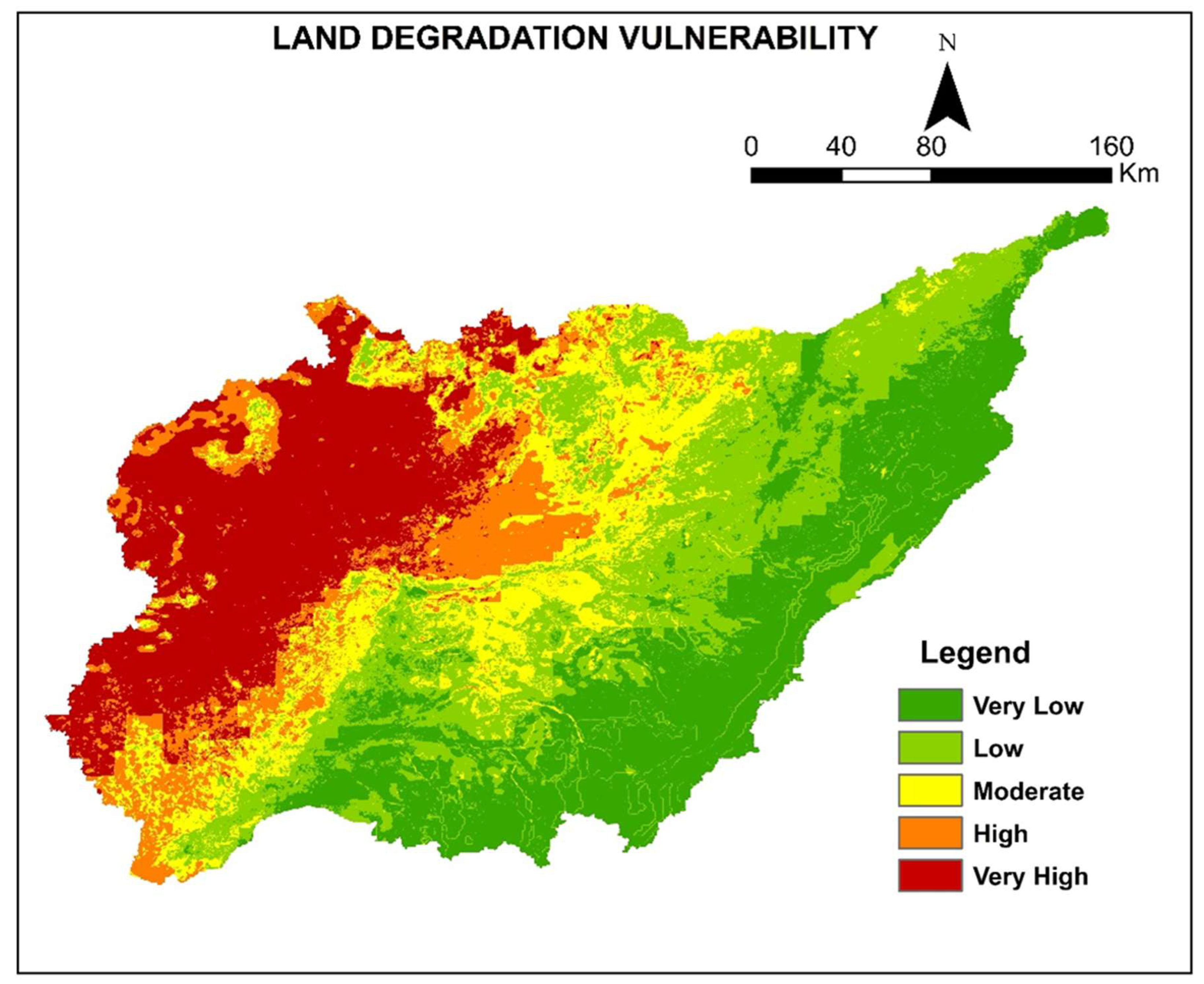
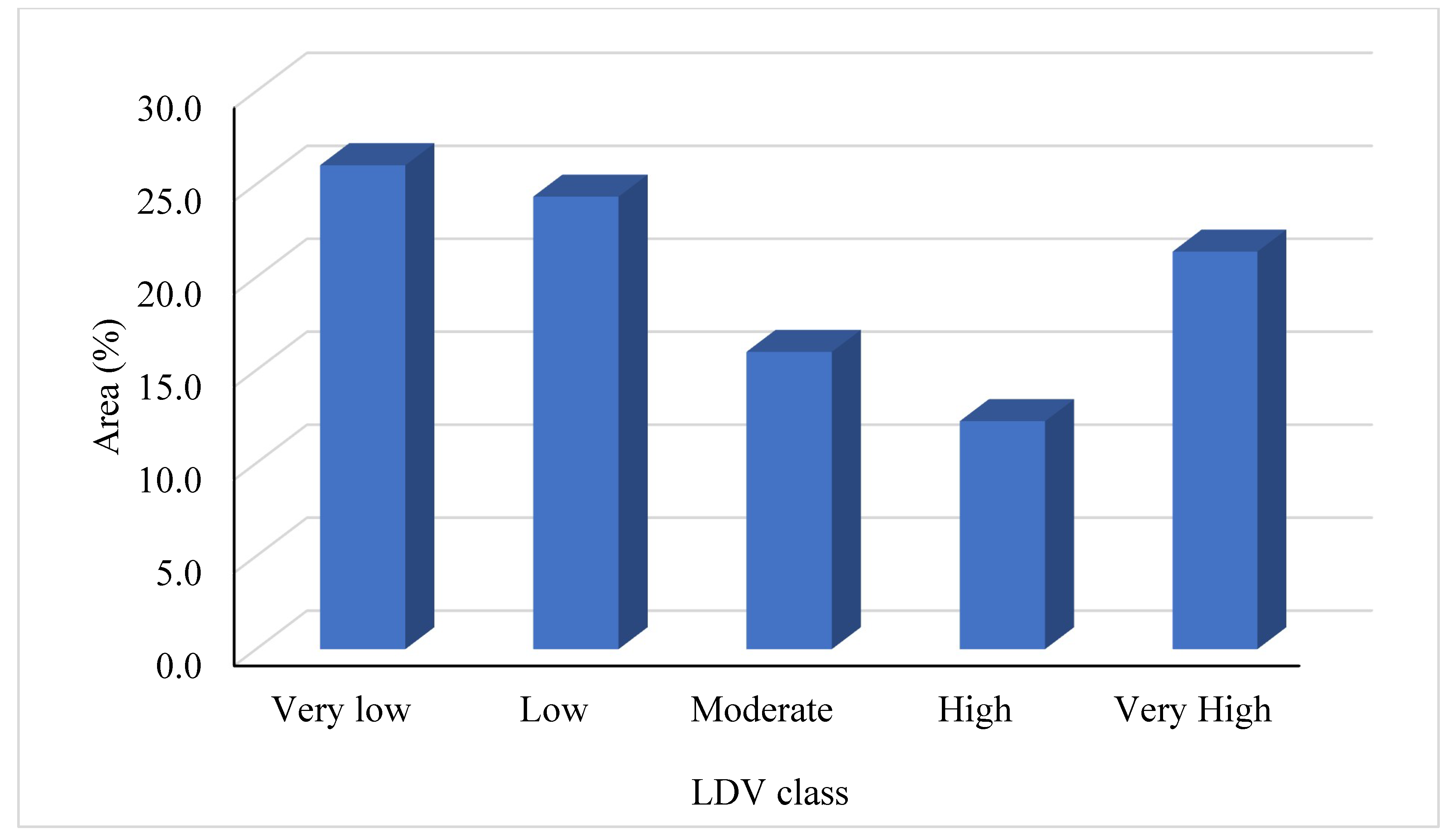
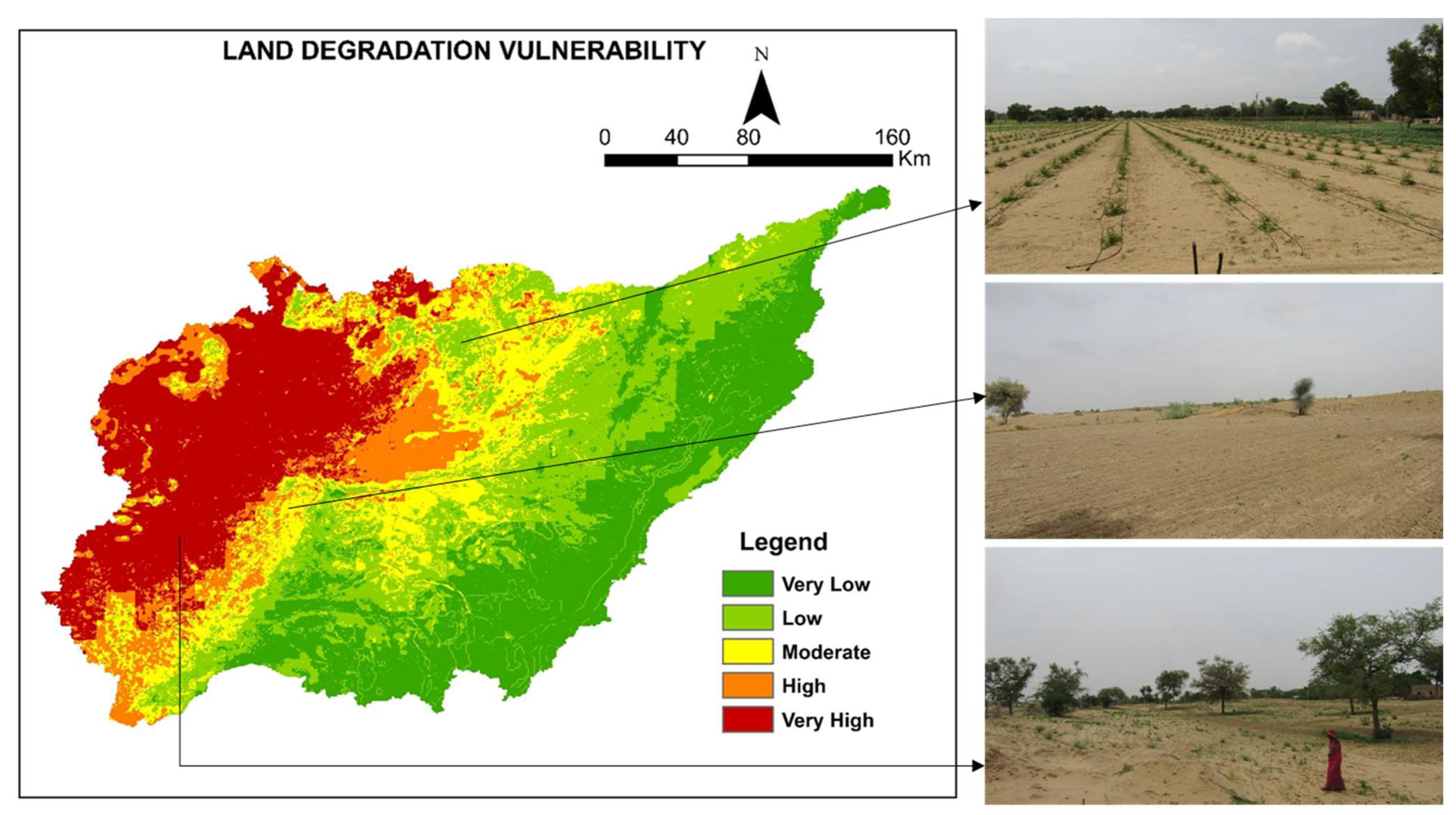
3.2. Land Degradation Vulnerability
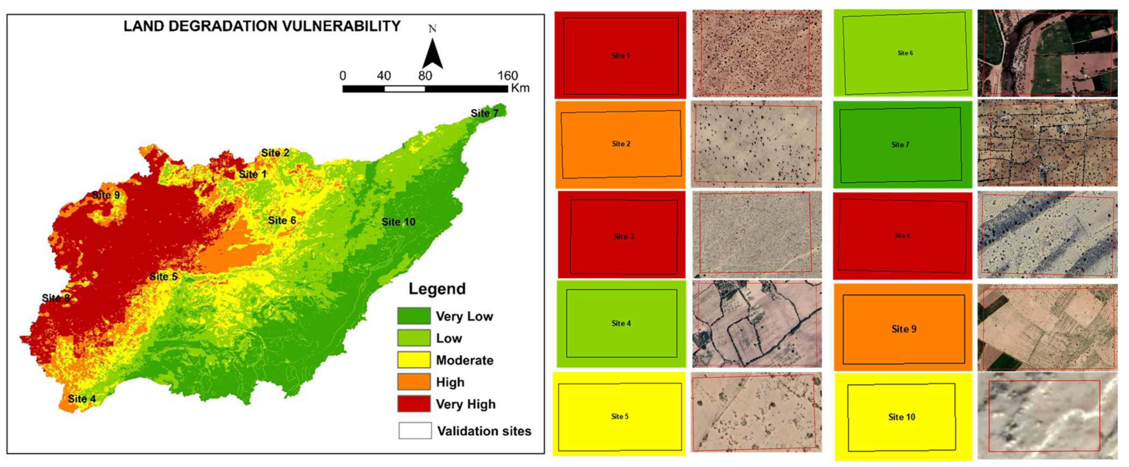
3.3. Validation of Land Degradation Vulnerability Zones
4. Discussion
5. Conclusions
Author Contributions
Funding
Institutional Review Board Statement
Informed Consent Statement
Data Availability Statement
Acknowledgments
Conflicts of Interest
References
- Tagore, G.S.; Bairagi, G.D.; Sharma, N.K.; Sharma, R.; Bhelawe, S.; Verma, P.K. Mapping of Degraded Lands Using Remote Sensing and GIS Techniques. J. Agric. Phys. 2012, 12, 29–36. [Google Scholar]
- UNCCD. The Global Land Outlook, 1st ed.; United Nations Convention to Combat Desertification: New York, NY, USA, 2017. [Google Scholar]
- D’Odorico, P.; Ravi, S. Land degradation and environmental change. In Biological and Environmental Hazards, Risks, and Disasters; Academic Press: Cambridge, MA, USA; Elsevier: Amsterdam, The Netherlands, 2016; pp. 219–227. [Google Scholar]
- Parmar, M.; Bhawsar, Z.; Kotecha, M.; Shukla, A.; Rajawat, A.S. Assessment of land degradation vulnerability using geospatial technique: A case study of Kachchh District of Gujarat, India. J. Indian Soc. Remote Sens. 2021, 49, 1661–1675. [Google Scholar] [CrossRef]
- UNCCD. Elaboration of an International Convention to Combat Desertification in Countries Experiencing Serious Drought and/or Desertification, Particularly in Africa; United Nations: New York, NY, USA, 1994. [Google Scholar]
- UNCCD. Desertification-Coping with Today’s Global Challenges in the Context of the Strategy of the UNCCD; United Nations Convention to Combat Desertification: Bonn, Germany, 2008. [Google Scholar]
- Barbero-Sierra, C.; Marques, M.J.; Ruiz-Pérez, M.; Escadafal, R.; Exbrayat, W. How is desertification research addressed in Spain? Land versus soil approaches. Land Degrad. Dev. 2015, 26, 423–432. [Google Scholar] [CrossRef]
- Fleskens, L.; Stringer, L.C. Land management and policy responses to mitigate desertification and land degradation. Land Degrad. Dev. 2014, 25, 1–4. [Google Scholar] [CrossRef]
- Orusa, T.; Orusa, R.; Viani, A.; Carella, E.; Borgogno Mondino, E. Geomatics and EO data to support wildlife diseases assessment at landscape level: A pilot experience to map infectious keratoconjunctivitis in chamois and phenological trends in Aosta Valley (NW Italy). Remote Sens. 2020, 12, 3542. [Google Scholar] [CrossRef]
- Prăvălie, R.; Patriche, C.; Borrelli, P.; Panagos, P.; Roșca, B.; Dumitraşcu, M.; Nita, I.A.; Săvulescu, I.; Birsan, M.V.; Bandoc, G. Arable lands under the pressure of multiple land degradation processes. A global perspective. Environ. Res. 2021, 194, 110697. [Google Scholar] [CrossRef]
- Lal, R. Adaptation and Mitigation of Climate Change by Improving Agriculture in India. In Climate Change and Agriculture in India: Impact and Adaptation; Sheraz Mahdi, S., Ed.; Springer: Cham, Switzerland, 2019. [Google Scholar]
- Romshoo, S.A.; Amin, M.; Sastry, K.L.N.; Parmar, M. Integration of social, economic, and environmental factors in GIS for land degradation vulnerability assessment in the Pir Panjal Himalaya, Kashmir, India. Appl. Geogr. 2020, 125, 102307. [Google Scholar] [CrossRef]
- Bhattacharyya, R.; Ghosh, B.N.; Mishra, P.K.; Mandal, B.; Rao, C.S.; Sarkar, D.; Das, K.; Anil, K.S.; Lalitha, M.; Hati, K.M.; et al. Soil degradation in India: Challenges and potential solutions. Sustainability 2015, 7, 3528–3570. [Google Scholar] [CrossRef]
- Srinivasarao, C.; Chary, G.R.; Raju, B.M.K.; Jakkula, V.S.; Rani, Y.S.; Rani, N. Land use planning for low rainfall (450–750 mm) regions of India. Agropedology 2014, 24, 197–221. [Google Scholar]
- Singh, K.; Tewari, S.K. Does the road to land degradation neutrality in India is paved with restoration science? Restor. Ecol. 2021, 30, e13585. [Google Scholar] [CrossRef]
- Goyal, R.K.; Saxena, A.; Moharana, P.C.; Pandey, C.B. Crop water demand under climate change scenarios for western Rajasthan. Ann. Arid Zone 2013, 52, 89–94. [Google Scholar]
- Kar, A.; Moharana, P.C.; Raina, P.; Kumar, M.; Soni, M.L.; Santra, P.; Ajai; Arya, A.S.; Dhinwa, P.S. Desertification and its control measures. In Trends in Arid ZoneResearches in India; Kar, A., Garg, B.K., Singh, M.P., Kathju, S., Eds.; Central AridZone Research Institute: Jodhpur, India, 2009; pp. 1–47. [Google Scholar]
- Moharana, P.C.; Gaur, M.K.; Chaudhary, C.; Chauhan, J.S.; Rajpurohit, R.S. Asystem of Geomorphological mapping for western Rajasthan with relevance foragricultural land use. Ann. Arid Zone 2013, 52, 163–180. [Google Scholar]
- Santra, P.; Moharana, P.C.; Kumar, M.; Soni, M.L.; Pandey, C.B.; Chaudhari, S.K.; Sikka, A.K. Crop production and economic loss due to wind erosion in hot arid ecosystem of India. Aeolian Res. 2017, 28, 71–82. [Google Scholar] [CrossRef]
- Selmy, S.A.; Abd Al-Aziz, S.H.; Jiménez-Ballesta, R.; García-Navarro, F.J.; Fadl, M.E. Modeling and Assessing Potential Soil Erosion Hazards Using USLE and Wind Erosion Models in Integration with GIS Techniques: Dakhla Oasis, Egypt. Agriculture 2021, 11, 1124. [Google Scholar] [CrossRef]
- AbdelRahman, M.A.E. Estimating soil fertility status in physically degraded land using GIS and remote sensing techniques in Chamarajanagar district, Karnataka, India. Egypt. J. Remote Sens. Space Sci. 2016, 19, 95–108. [Google Scholar] [CrossRef]
- Sujatha, G.; Dwivedi, R.S.; Sreenivas, K.; Venkataratnam, L. Mapping and monitoring of degraded lands in part of Jaunpur district of Uttar Pradesh using temporal spaceborne multispectral data. Int. J. Remote Sens. 2000, 21, 519–531. [Google Scholar] [CrossRef]
- AbdelRahman, M.A.E.; Tahoun, S.A.; Abdel Bary, E.A.; Arafat, S.M. Detecting Land Degradation Processes Using Geo Statistical Approach in Port Said, Egypt. Zagazig J. Agric. Res. 2008, 35, 1361–1379. [Google Scholar]
- Reddy, G.P.O.; Kumar, N.; Singh, S.K. Remote Sensing and GIS in Mapping and Monitoring of Land Degradation. In Geospatial Technologies in Land Resources Mapping, Monitoring and Management; Reddy, G.P.O., Singh, S.K., Eds.; Geotechnologies and the Environment; Springer: Cham, Switzerland, 2018; Volume 21, pp. 401–424. [Google Scholar]
- Jong, R.; Bruin, S.; Schaepman, M.; Dent, D. Quantitative mapping of global land degradation using earth observations. Int. J. Remote Sens. 2011, 32, 6823–6847. [Google Scholar] [CrossRef]
- Higginbottom, T.; Symeonakis, E. Assessing land degradation and desertification using vegetation index data: Current frameworks and future directions. Remote Sens. 2014, 6, 9552–9575. [Google Scholar] [CrossRef]
- Yousefi, S.; Pourghasemi, H.R.; Avand, M.; Janizadeh, S.; Tavangar, S.; Santosh, M. Assessment of land degradation using machine-learning techniques: A case of declining rangelands. Land Degrad. Dev. 2021, 32, 1452–1466. [Google Scholar] [CrossRef]
- Basu, T.; Das, A.; Pham, Q.B.; Al-Ansari, N.; Linh, N.T.T.; Lagerwall, G. Development of an integrated peri-urban wetland degradation assessment approach for the Chatra Wetland in eastern India. Sci. Rep. 2021, 11, 1–22. [Google Scholar]
- Chen, L.; Ren, C.; Li, L.; Wang, Y.; Zhang, B.; Wang, Z.; Li, L. A comparative assessment of geostatistical, machine learning, and hybrid approaches for mapping topsoil organic carbon content. ISPRS Int. J. GeoInf. 2019, 8, 174. [Google Scholar] [CrossRef]
- Li, Z.; Wang, S.; Song, S.; Wang, Y.; Musakwa, W. Detecting land degradation in Southern Africa using Time Series Segment and Residual Trend (TSS-RESTREND). J. Arid Environ. 2021, 184, 104314. [Google Scholar] [CrossRef]
- Waltner, I.; Saeidi, S.; Grósz, J.; Centeri, C.; Laborczi, A.; Pásztor, L. Spatial assessment of the effects of land cover change on soil erosion in Hungary from 1990 to 2018. ISPRS Int. J. Geo-Inf. 2020, 9, 667. [Google Scholar] [CrossRef]
- Lahlaoi, H.; Hassan, R.; Atika, H.; Said, L.; Said, M. Desertification assessment using MEDALUS model in Watershed Oued El Maleh Morocco. Geoscience 2017, 7, 50. [Google Scholar] [CrossRef]
- Rabah, B.; Aida, B. Adaptation of MEDALUS method for the analysis depicting land degradation in Oued Labiod Valley (Eastern Algeria). In Advances in Remote Sensing and Geo Informatics Applications; El-Askary, H.M., Lee, S., Heggy, E., Pradhan, B., Eds.; Springer: Dordrecht, The Netherlands, 2018. [Google Scholar]
- Abuzaid, A.S.; AbdelRahman, M.A.; Fadl, M.E.; Scopa, A. Land degradation vulnerability mapping in a newly-reclaimed desert oasis in a hyper-arid agro-ecosystem using AHP and geospatial techniques. Agronomy 2021, 11, 1426. [Google Scholar] [CrossRef]
- Tolche, A.D.; Gurara, M.A.; Pham, Q.B.; Anh, D.T. Modelling and accessing land degradation vulnerability using remote sensing techniques and the analytical hierarchy process approach. Geocarto Int. 2021, 1–21. [Google Scholar] [CrossRef]
- Wu, Q.; Wang, M. A framework for risk assessment on soil erosion by water using an integrated and systematic approach. J. Hydrol. 2007, 337, 11–21. [Google Scholar] [CrossRef]
- Alexakis, D.D.; Hadjimitsis, D.G.; Agapiou, A. Integrated use of remote sensing, GIS and precipitation data for the assessment of soil erosion rate in the catchment area of “Yialias” in Cyprus. Atmos. Res. 2013, 131, 108–124. [Google Scholar] [CrossRef]
- Sandeep, P.; Reddy, G.P.O.; Jegankumar, R.; Arun Kumar, K.C. Modeling, and assessment of land degradation vulnerability in semi-arid ecosystem of Southern India using temporal satellite data, AHP and GIS. Environ. Model. Assess. 2021, 26, 143–154. [Google Scholar] [CrossRef]
- Singh, M.; Urmila, P.S.; Yadav, K.; Bhakar, S.; Kothati, M. Site suitability analysis for groundwater management in river basin of India. Poll Res. 2022, 41, 132–139. [Google Scholar] [CrossRef]
- Kumar, M.D.; Bassi, N.; James, A.J. Water accounting for Luni river basin, western Rajasthan. In From Catchment Management to Managing River Basins: Science, Technology Choices, Institutions and Policy; Reddy, R., James, A.J., Eds.; Elsevier: Amsterdam, The Netherlands, 2019. [Google Scholar]
- Karra, K.; Kontgis, C.; Statman-Weil, Z.; Mazzariello, J.C.; Mathis, M.; Brumby, S.P. Global land use/land cover with Sentinel 2 and deep learning. In Proceedings of the 2021 IEEE International Geoscience and Remote Sensing Symposium IGARSS, Brussels, Belgium, 1–16 July 2021; pp. 4704–4707. [Google Scholar]
- Jiang, L.; Jiapaer, G.; Bao, A.; Kurban, A.; Guo, H.; Zheng, G.; De Maeyer, P. Monitoring the long-term desertification process and assessing the relative roles of its drivers in Central Asia. Ecol. Indic. 2019, 104, 195–208. [Google Scholar] [CrossRef]
- Malav, L.C.; Yadav, B.; Tailor, B.L.; Pattanayak, S.; Singh, S.V.; Kumar, N.; Reddy, G.P.O.; Mina, B.L.; Dwivedi, B.S.; Jha, P.K. Mapping of Land Degradation Vulnerability in the Semi-Arid Watershed of Rajasthan, India. Sustainability 2022, 14, 10198. [Google Scholar] [CrossRef]
- Wu, H.; Guo, B.; Fan, J.; Yang, F.; Han, B.; Wei, C.; Lu, Y.; Zang, W.; Zhen, X.; Meng, C. A novel remote sensing ecological vulnerability index on large scale: A case study of the China-Pakistan Economic Corridor region. Ecol. Indic. 2021, 129, 107955. [Google Scholar] [CrossRef]
- Akay, H. Flood hazards susceptibility mapping using statistical, fuzzy logic, and MCDM methods. Soft Comput. 2021, 25, 9325–9346. [Google Scholar] [CrossRef]
- Chen, S.; Liu, W.; Bai, Y.; Luo, X.; Li, H.; Zha, X. Evaluation of watershed soil erosion hazard using combination weight and GIS: A case study from eroded soil in Southern China. Nat. Hazards 2021, 109, 1603–1628. [Google Scholar] [CrossRef]
- Neji, N.; Ayed, R.B.; Abida, H. Water erosion hazard mapping using analytic hierarchy process (AHP) and fuzzy logic modeling: A case study of the Chaffar Watershed (Southeastern Tunisia). Arab. J. Geosci. 2021, 14, 1–15. [Google Scholar] [CrossRef]
- Alam, N.M.; Jana, C.; Mandal, D.; Meena, S.K.; Shrimali, S.S.; Mandal, U.; Mitra, S.; Kar, G. Applying Analytic Hierarchy Process for Identifying Best Management Practices in Erosion Risk Areas of Northwestern Himalayas. Land 2022, 11, 832. [Google Scholar] [CrossRef]
- Mukherjee, I.; Singh, U.K. Delineation of groundwater potential zones in a drought-prone semi-arid region of east India using GIS and analytical hierarchical process techniques. Catena 2020, 194, 104681. [Google Scholar] [CrossRef]
- Saaty, T.L. How to make a decision: The analytic hierarchy process. Interfaces 1994, 26, 19–43. [Google Scholar] [CrossRef]
- Torabi Haghighi, A.; Darabi, H.; Karimidastenaei, Z.; Davudirad, A.A.; Rouzbeh, S.; Rahmati, O.; Sajedi-Hosseini, F.; Klöve, B. Land degradation risk mapping using topographic, human-induced, and geo-environmental variables and machine learning algorithms, for the Pole-Doab watershed, Iran. Environ. Earth Sci. 2021, 80, 1–21. [Google Scholar] [CrossRef]
- Emmanuel, O. Effects of Deforestation on Land Degradation; LAP LAMBERT Academic Publishing: Ado Ekiti, Nigeria, 2017. [Google Scholar]
- Lennart, O.; Humberto, B. Climate Change and Land: An IPCC Special Report on Climate Change, Desertification, Land Degradation, Sustainable Land Management, Food Security, and Greenhouse Gas Fluxes in Terrestrial Ecosystems (Sweden: Land Degradation); Moreno, J.M., Ed.; IPCC: Geneva, Switzerland, 2019.
- Singh, S.; Kar, A.; Joshi, D.C.; Kumar, S.; Sharma, K.D. Desertification problem in western Rajasthan. Ann. Arid Zone 1994, 33, 191. [Google Scholar]
- Houyou, Z.; Bielders, C.L.; Benhorma, H.A.; Dellal, A.; Boutemdjet, A. Evidence of strong land degradation by wind erosion as a result of rainfed cropping in the Algerian steppe: A case study at Laghouat. Land Degrad. Dev. 2016, 27, 1788–1796. [Google Scholar] [CrossRef]
- Faramarzi, M.; Heidarizadi, Z.; Mohamadi, A.; Heydari, M. Detection of vegetation changes in relation to normalized difference vegetation index (NDVI) in semi-arid rangeland in western Iran. J. Agric. Sci. Technol. 2018, 20, 51–60. [Google Scholar]
- Yang, L.; Sun, G.; Zhi, L.; Zhao, J. Negative soil moisture-precipitation feedback in dry and wet regions. Sci. Rep. 2018, 8, 4026. [Google Scholar] [CrossRef]
- Tolessa, T.; Dechassa, C.; Simane, B.; Alamerew, B.; Kidane, M. Land use/land cover dynamics in response to various driving forces in Didessa sub-basin, Ethiopia. GeoJournal 2020, 85, 747–760. [Google Scholar] [CrossRef]
- Bronick, C.J.; Lal, R. Soil structure and management: A review. Geoderma 2005, 124, 3–22. [Google Scholar] [CrossRef]
- Mahmoodabadi, M.; Ahmadbeigi, B. Dry and water-stable aggregates in different cultivation systems of arid region soils. Arab. J. Geosi. 2013, 6, 2997–3002. [Google Scholar] [CrossRef]
- Belnap, J.; Phillips, S.L.; Herrick, J.E.; Johansen, J.R. Wind erodibility of soils at Fort Irwin, California (Mojave Desert), USA, before and after trampling disturbance: Implications for land management. Earth Surf. Process. Landf. 2007, 32, 75–84. [Google Scholar] [CrossRef]
- Pásztor, L.; Négyesi, G.; Laborczi, A.; Kovács, T.; László, E.; Bihari, Z. Integrated spatial assessment of wind erosion risk in Hungary. Nat. Hazards Earth Syst. Sci. 2016, 16, 2421–2432. [Google Scholar] [CrossRef]
- Chepil, W.S.; Woodruff, N.P. The physics of wind erosion and its control. Adv. Agron. 1963, 15, 211–302. [Google Scholar]
- Colazo, J.C.; Buschiazzo, D.E. Soil dry aggregate stability and wind erodible fraction in a semiarid environment of Argentina. Geoderma 2010, 159, 228–236. [Google Scholar] [CrossRef]
- Frasetya, B.; Suriadikusumah, A.; Haryanto, R.; Hidayat, C. A new approach of soil degradation assessment for biomass production in Subang District West Java Province. IOP Conf. Ser. Earth Environ. Sci. 2019, 393, 012075. [Google Scholar] [CrossRef]
- Zhou, Y.; Guo, B.; Wang, S.; Tao, H. An estimation method of soil wind erosion in Inner Mongolia of China based on geographic information system and remote sensing. J. Arid Land 2015, 7, 304–317. [Google Scholar] [CrossRef]
- AbdelRahman, M.A.; Natarajan, A.; Hegde, R.; Prakash, S.S. Assessment of land degradation using comprehensive geostatistical approach and remote sensing data in GIS-model builder. Egypt. J. Remote Sens. Space Sci. 2019, 22, 323–334. [Google Scholar] [CrossRef]
- Mzuri, R.T.; Mustafa, Y.T.; Omar, A.A. Land degradation assessment using AHP and GIS-based modelling in Duhok District, Kurdistan Region, Iraq. Geocarto Int. 2021, 1–19. [Google Scholar] [CrossRef]
- Rukhovich, D.I.; Koroleva, P.V.; Rukhovich, D.D.; Kalinina, N.V. The use of deep machine learning for the automated selection of remote sensing data for the determination of areas of arable land degradation processes distribution. Remote Sens. 2021, 13, 155. [Google Scholar] [CrossRef]
- Hereher, M.; El-Kenawy, A. Assessment of land degradation in northern Oman using geospatial techniques. Earth Syst. Environ. 2022, 6, 469–482. [Google Scholar] [CrossRef]
- Hein, L. The impacts of grazing and rainfall variability on the dynamics of a Sahelian rangeland. J. Arid Environ. 2006, 64, 488–504. [Google Scholar] [CrossRef]
- Fensholt, R.; Rasmussen, K.; Kaspersen, P.; Huber, S.; Horion, S.; Swinnen, E. Assessing land degradation/ recovery in the african sahel from long-term earth observation based primary productivity and precipitation relationships. Remote Sens. 2013, 5, 664–686. [Google Scholar] [CrossRef]
- Ambarwulan, W.; Nahib, I.; Widiatmaka, W.; Suryanta, J.; Munajati, S.L.; Suwarno, Y.; Turmudi, T.; Darmawan, M.; Sutrisno, D. Using Geographic Information Systems and the Analytical Hierarchy Process for Delineating Erosion-Induced Land Degradation in the Middle Citarum Sub-Watershed, Indonesia. Front. Environ. Sci. 2021, 9, 710570. [Google Scholar] [CrossRef]
- Balasubramani, K.; Veena, M.; Kumaraswamy, K.; Saravanabavan, V. Estimation of soil erosion in a semi-arid watershed of Tamil Nadu (India) using revised universal soil loss equation (rusle) model through GIS. Model. Earth Syst. Environ. 2015, 1, 1–17. [Google Scholar] [CrossRef]
- Ghosh, A.; Maiti, R. Development of new Ecological Susceptibility Index (ESI) for monitoring ecological risk of river corridor using F-AHP and AHP and its application on the Mayurakshi river ofEastern India. Ecol. Inform. 2021, 63, 101318. [Google Scholar] [CrossRef]
- Nikhil, S.; Danumah, J.H.; Saha, S.; Prasad, M.K.; Rajaneesh, A.; Mammen, P.C.; Ajin, R.S.; Kuriakose, S.L. Application of GIS and AHP Method in Forest Fire Risk Zone Mapping: A Study of the Parambikulam Tiger Reserve, Kerala, India. J. Geovisualization Spat. Anal. 2021, 5, 14. [Google Scholar] [CrossRef]
- Senapati, U.; Das, T.K. Assessment of basin-scale groundwater potentiality mapping in drought-prone upper Dwarakeshwar River basin, West Bengal, India, using GIS-based AHP techniques. Arab. J. Geosci. 2021, 14, 960. [Google Scholar] [CrossRef]
- Pourghasemi, H.R.; Beheshtirad, M.; Pradhan, B. A comparative assessment of prediction capabilities of modified analytical hierarchy process (M-AHP) and Mamdani fuzzy logic models using Netcad-GIS for forest fire susceptibility mapping. Geomat. Nat. Hazards Risk 2016, 7, 861–885. [Google Scholar] [CrossRef]
- Abedi, R.; Costache, R.; Shafizadeh-Moghadam, H.; Pham, Q.B. Flash-flood susceptibility mapping based on XGBoost, random forest and boosted regression trees. Geocarto Int. 2021, 37, 5479–5496. [Google Scholar] [CrossRef]
- Halbac-Cotoara-Zamfir, R.; Smiraglia, D.; Quaranta, G.; Salvia, R.; Salvati, L.; Giménez-Morera, A. Land degradation and mitigation policies in the Mediterranean region: A brief commentary. Sustainability 2020, 12, 8313. [Google Scholar] [CrossRef]



| S.No. | Data Source | Variable | Temporal Resolution | Spatial Resolution | Period |
|---|---|---|---|---|---|
| 1 | MODIS MOD13Q1 | NDVI | 16 days | 250 m | 2001–2021 |
| 2 | MODIS MOD11A2 | LST | 8 days | 1 km | 2001–2021 |
| 3 | ESRI LULC | LULC | - | 10 m | - |
| 4 | SRTM DEM | Slope | - | 30 m | - |
| 5 | SoilGrids250 m | Soil organic carbon | - | 250 m | - |
| 6 | CHIRPS | Rainfall | - | 5 km | 2001–2021 |
| 7 | ICAR-NBSS & LUP, Nagpur | Soil texture, erosion, and depth | - | 1:250,000 | - |
| Scale | Importance |
|---|---|
| 1 | Equal importance |
| 2 | Intermediate between scale 1 and 3 |
| 3 | Moderate importance |
| 4 | Intermediate between scale 3 and 5 |
| 5 | Strong importance |
| 6 | Intermediate between scale 5 and 7 |
| 7 | Very strong importance |
| 8 | Intermediate between scale 7 and 9 |
| 9 | Extreme importance |
| N | 1 | 2 | 3 | 4 | 5 | 6 | 7 | 8 | 9 | 10 | 11 |
|---|---|---|---|---|---|---|---|---|---|---|---|
| RCI | 0 | 0 | 0.58 | 0.9 | 1.12 | 1.24 | 1.32 | 1.41 | 1.45 | 1.49 | 1.51 |
| NDVI | MAR | LST | SE | Slope | LULC | SOC | ST | SD | Normalized Weight | CR | |
|---|---|---|---|---|---|---|---|---|---|---|---|
| NDVI | 1 | 2 | 2 | 3 | 4 | 5 | 5 | 7 | 9 | 0.27 | 0.075 |
| MAR | 0.5 | 1 | 2 | 3 | 4 | 4 | 6 | 6 | 8 | 0.22 | |
| LST | 0.5 | 0.5 | 1 | 2 | 3 | 3 | 4 | 5 | 7 | 0.15 | |
| SE | 0.3 | 0.3 | 0.5 | 1 | 2 | 3 | 4 | 5 | 8 | 0.12 | |
| Slope | 0.3 | 0.3 | 0.3 | 0.5 | 1 | 2 | 3 | 4 | 5 | 0.08 | |
| LULC | 0.2 | 0.3 | 0.3 | 0.3 | 0.5 | 1 | 2 | 4 | 5 | 0.06 | |
| SOC | 0.2 | 0.2 | 0.3 | 0.3 | 0.3 | 0.5 | 1 | 2 | 4 | 0.04 | |
| ST | 0.1 | 0.2 | 0.2 | 0.2 | 0.3 | 0.3 | 0.5 | 1 | 3 | 0.03 | |
| SD | 0.1 | 0.1 | 0.1 | 0.1 | 0.2 | 0.2 | 0.3 | 0.3 | 1 | 0.02 |
| NDVI | MAR | LST | SE | Slope | LULC | SOC | ST | SD | |
|---|---|---|---|---|---|---|---|---|---|
| NDVI | 0.31 | 0.42 | 0.30 | 0.29 | 0.26 | 0.26 | 0.19 | 0.20 | 0.18 |
| MAR | 0.15 | 0.21 | 0.30 | 0.29 | 0.26 | 0.21 | 0.23 | 0.17 | 0.16 |
| LST | 0.15 | 0.10 | 0.15 | 0.19 | 0.20 | 0.16 | 0.16 | 0.15 | 0.14 |
| SE | 0.10 | 0.07 | 0.07 | 0.10 | 0.13 | 0.16 | 0.16 | 0.15 | 0.16 |
| Slope | 0.08 | 0.05 | 0.05 | 0.05 | 0.07 | 0.11 | 0.12 | 0.12 | 0.1 |
| LULC | 0.06 | 0.05 | 0.05 | 0.03 | 0.03 | 0.05 | 0.08 | 0.12 | 0.1 |
| SOC | 0.06 | 0.03 | 0.04 | 0.02 | 0.02 | 0.03 | 0.04 | 0.06 | 0.08 |
| ST | 0.04 | 0.03 | 0.03 | 0.02 | 0.02 | 0.01 | 0.02 | 0.03 | 0.06 |
| SD | 0.03 | 0.03 | 0.02 | 0.01 | 0.01 | 0.01 | 0.01 | 0.01 | 0.02 |
| Thematic Layer | Subclass | Weight | CR |
|---|---|---|---|
| NDVI | −0.03–0.19 | 0.521 | 0.093 |
| 0.19–0.24 | 0.271 | ||
| 0.24–0.29 | 0.107 | ||
| 0.29–0.36 | 0.066 | ||
| 0.36–0.60 | 0.035 | ||
| MAR (mm) | 234–401 | 0.498 | 0.091 |
| 401–524 | 0.267 | ||
| 524–685 | 0.125 | ||
| 685–941 | 0.075 | ||
| 941–1654 | 0.035 | ||
| LST (°C) | 27–34 | 0.039 | 0.097 |
| 34–36 | 0.064 | ||
| 36–37 | 0.108 | ||
| 37–39 | 0.223 | ||
| 39–43 | 0.566 | ||
| SE | Slight | 0.049 | 0.099 |
| Moderate | 0.103 | ||
| Severe | 0.222 | ||
| Very severe | 0.626 | ||
| Slope (%) | >50 | 0.030 | 0.098 |
| 30–50 | 0.045 | ||
| 15–30 | 0.081 | ||
| 8–15 | 0.141 | ||
| 3–8 | 0.247 | ||
| <3 | 0.456 | ||
| LULC | Water bodies/built up (urban/rural) | 0.025 | 0.097 |
| Deciduous forest | 0.033 | ||
| Forest (shrub/scrub/degraded) | 0.053 | ||
| Cropland | 0.089 | ||
| Land with shrub/scrub | 0.147 | ||
| Current fallow land | 0.236 | ||
| Gullied/ravines/other wastelands | 0.418 | ||
| SOC (decigram/kg) | 0–52 | 0.521 | 0.093 |
| 52–67 | 0.271 | ||
| 67–93 | 0.107 | ||
| 93–140 | 0.066 | ||
| 140–315 | 0.035 | ||
| ST | Loam/clay loam/fine loam | 0.033 | 0.083 |
| Loamy skeletal | 0.067 | ||
| Sandy skeletal | 0.141 | ||
| Sandy | 0.289 | ||
| Rock | 0.469 | ||
| SD (cm) | Rock | 0.433 | 0.095 |
| <25 | 0.276 | ||
| 25–50 | 0.137 | ||
| 50–75 | 0.083 | ||
| 75–100 | 0.041 | ||
| >100 | 0.030 |
Disclaimer/Publisher’s Note: The statements, opinions and data contained in all publications are solely those of the individual author(s) and contributor(s) and not of MDPI and/or the editor(s). MDPI and/or the editor(s) disclaim responsibility for any injury to people or property resulting from any ideas, methods, instructions or products referred to in the content. |
© 2022 by the authors. Licensee MDPI, Basel, Switzerland. This article is an open access article distributed under the terms and conditions of the Creative Commons Attribution (CC BY) license (https://creativecommons.org/licenses/by/4.0/).
Share and Cite
Yadav, B.; Malav, L.C.; Jiménez-Ballesta, R.; Kumawat, C.; Patra, A.; Patel, A.; Jangir, A.; Nogiya, M.; Meena, R.L.; Moharana, P.C.; et al. Modeling and Assessment of Land Degradation Vulnerability in Arid Ecosystem of Rajasthan Using Analytical Hierarchy Process and Geospatial Techniques. Land 2023, 12, 106. https://doi.org/10.3390/land12010106
Yadav B, Malav LC, Jiménez-Ballesta R, Kumawat C, Patra A, Patel A, Jangir A, Nogiya M, Meena RL, Moharana PC, et al. Modeling and Assessment of Land Degradation Vulnerability in Arid Ecosystem of Rajasthan Using Analytical Hierarchy Process and Geospatial Techniques. Land. 2023; 12(1):106. https://doi.org/10.3390/land12010106
Chicago/Turabian StyleYadav, Brijesh, Lal Chand Malav, Raimundo Jiménez-Ballesta, Chiranjeev Kumawat, Abhik Patra, Abhishek Patel, Abhishek Jangir, Mahaveer Nogiya, Roshan Lal Meena, Pravash Chandra Moharana, and et al. 2023. "Modeling and Assessment of Land Degradation Vulnerability in Arid Ecosystem of Rajasthan Using Analytical Hierarchy Process and Geospatial Techniques" Land 12, no. 1: 106. https://doi.org/10.3390/land12010106
APA StyleYadav, B., Malav, L. C., Jiménez-Ballesta, R., Kumawat, C., Patra, A., Patel, A., Jangir, A., Nogiya, M., Meena, R. L., Moharana, P. C., Kumar, N., Sharma, R. P., Yadav, L. R., Obi Reddy, G. P., & Mina, B. L. (2023). Modeling and Assessment of Land Degradation Vulnerability in Arid Ecosystem of Rajasthan Using Analytical Hierarchy Process and Geospatial Techniques. Land, 12(1), 106. https://doi.org/10.3390/land12010106


