1. Introduction
Settlements are a concrete manifestation of human occupation of the earth’s surface and are an important part of the formation of the surface’s form. At the same time, ancient settlements are places where ancient humans lived and carried out their production and social activities; they contain the rich material and spiritual connotations of human developmental history and are a valuable cultural heritage and spiritual treasure for contemporary times. Their temporal and spatial distribution was influenced by environmental, cultural, and political factors with different characteristics. The past, present, and future are in the same chain of time. The study of the spatial and temporal distribution and morphological characteristics of settlements can, therefore, provide a basis for the conservation of their heritage value, as well as be a reference for the reconciliation of human–land relations, thus contributing to global sustainable development.
The spatial distribution of settlements has been a subject of interest for a long time in a number of disciplines, including archaeology, geography, and architecture. Geographic Information Systems (GIS) have been applied to archaeological research since the 1980s. With the further development of GIS technology, there have been many successful examples of the application of GIS to settlement archaeological research, and the theory is gradually becoming mature [
1]. In recent years, numerous scholars have carried out studies on the Yangtze River basin [
2], the Minjiang River basin [
3], the Dalian region [
4], the Ili River valley [
5], and other regions within China. However, relatively few similar studies have been carried out in the lower reaches of the Yellow River Basin. Shandong, located on the lower reaches of the Yellow River, is one of the important birthplaces of Chinese civilisation, and archaeological work has shown that its cultural genealogy is well established. In chronological order, it includes: Yiyuan Man (about 400 ka B.P.), Xintai Wuzhutai Homo Sapiens (about 50–20 ka B.P.), the fine stone tool remains of the Yishu and Wensi river basins (about 10 ka B.P.), the early Neolithic culture (about 8.4–7.7 ka B.P.), the Beixin culture (7.3–6.1 ka B.P.), the Dawenkou culture (6.1–4.6 ka B.P.), the Longshan culture (4.6–4.0 ka B.P.), the Yueshi culture (4.0–3.6 ka B.P.), and all subsequent historical periods. Each of these periods are closely linked, and the cultural traditions have evolved in the same way [
6]. Within Shandong province, the Luzhong region (the centre of Shandong Province) is a relatively independent climatic, geographical, and cultural unit. Moreover, the political, economic, and cultural centre of Shandong has been located within this area since Linzi of Qi in the Spring and Autumn period. The Luzhong region is, therefore, a valuable case for studying the spatial and temporal distribution and characteristics of settlements at the core of Chinese civilisation. It can also enrich the case of settlement studies in the lower Yellow River Basin.
2. Materials and Methods
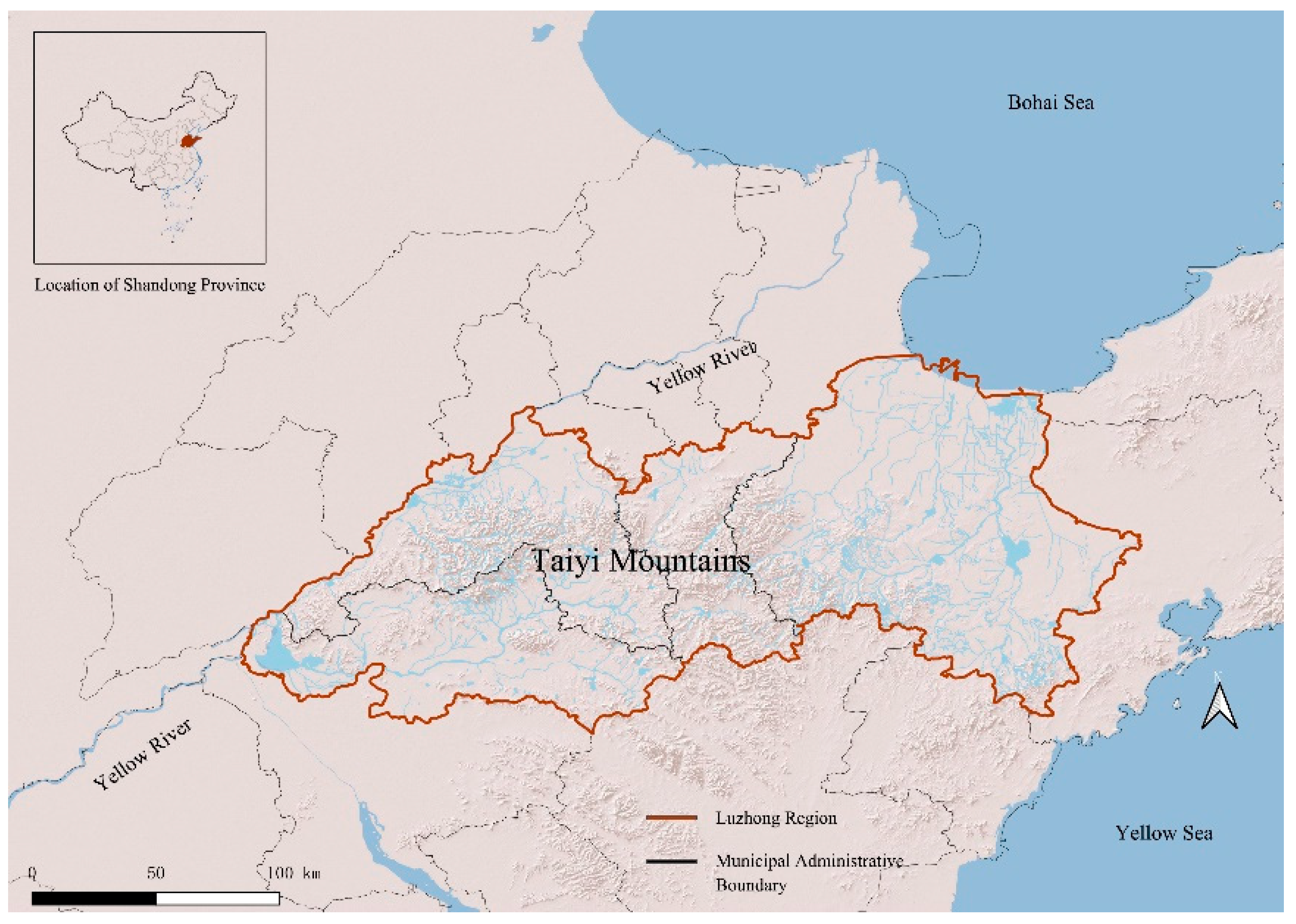
The spatial extent of this study, the Luzhong region, specifically includes Jinan (except Jiyang District and Shanghe County), Zibo (except Huantai County and Gaoqing County), Tai’an, and Weifang (
Figure 1). The climate in the Luzhong region is temperate monsoonal, with a more pronounced continental character. It is cold and dry in winter, and hot and rainy in summer. The average annual temperature is 12 °C–14 °C, and the annual precipitation is approximately 680–860 m [
7]. As can be seen from the map, the region has the Taiyi Mountains in the centre, which are surrounded by hilly undulations that transition into flat plains. In terms of water systems, the Yellow River flows through the territory. In addition, there are dense small- and medium-sized rivers, which have also developed their own water systems. This study covers the period from the Neolithic period to the Qing dynasty and is divided into six time periods according to cultural sequences: Neolithic, Shang and Zhou, Qin to Northern and Southern Dynasties, Sui to Five Dynasties, Song and Yuan, and Ming and Qing.
Based on the temporal and spatial scope of the study, a total of 1972 settlements were selected from the State Administration of Cultural Heritage [
8] and the National Cultural Heritage Administration [
9] by using “ancient city”, “old city”, “settlement site”, “fortified cities”, “fortresses”, “castle”, and “mountain city” as keywords. These data include all levels of cultural relic protection units and historic cities, towns, and villages. Thus, the data selected balanced representativeness and breadth, and they are able to reflect the spatial and temporal distribution characteristics and evolution patterns of settlements in the central Shandong region. In addition, the Digital Elevation Model (DEM) of the Luzhong region required for the research was derived from the GDEMV3 30 M resolution digital elevation data from the Geospatial Data Cloud website.
This paper analyses the spatial–temporal distribution and morphological characteristics of ancient settlements in the central Shandong region based on data from 1972 settlements and with the aid of a GIS system. Specifically, first, the 1972 data collected were divided into 6 stages according to cultural sequences (Neolithic, Shang and Zhou periods, Qin to North and South Dynasties, Sui to Five Dynasties, Song and Yuan Dynasties, Ming and Qing Dynasties) to establish a database of settlement attributes and perform kernel density calculations. Then, in the QGIS 3.22 software environment, the DEM map of the Luzhong area was overlaid with the settlement points to carry out the calculation of the elevation, slope, aspect, and buffer zone. At the same time, the spatial and temporal distribution characteristics of the settlements are comprehensively explored in relation to the historical context and dominant cultural forms in which the settlements were located. Based on the above quantitative and qualitative analyses, the distribution and evolutionary characteristics of the settlements are derived.
3. Results
3.1. Spatial and Temporal Distribution of Settlements
The database of ancient settlements in the Luzhong region, which was established by using GIS, directly reflects the distribution of settlements in each period. This helps to visualise the distribution pattern and spatial–temporal evolution of the ancient settlements in the Luzhong region in the timeline and facilitates the logical analysis and quantitative expression of the spatial–temporal evolution of the ancient settlements.
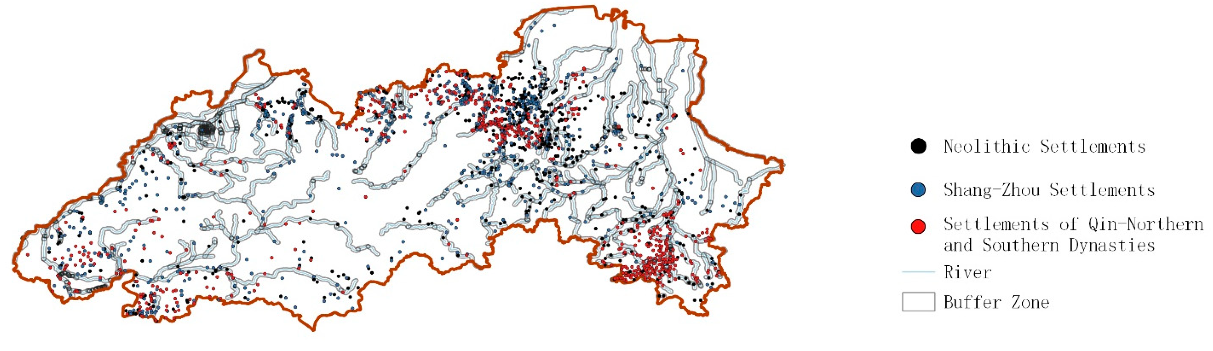
There have been human activities in the Luzhong area since the Stone Age, and a large number of settlements were built in the Neolithic period, with 638 Neolithic settlements in the Ancient Settlements Database for the Luzhong area. The Shang and Zhou Dynasties were the period with the most intensive construction activities in the region, with the number of settlements reaching 681. This was followed by a slight decline in the “Qin to Northern and Southern Dynasties” period, but the number of settlements remained high at 591. By this time, the settlement construction activities in the Luzhong region reached their peak, and the settlement system was constructed. Thereafter, there was only sporadic construction on this basis in the following three periods of “Sui to Five Dynasties’, “Song and Yuan Dynasties’, and “Ming and Qing Dynasties” (
Table 1).
The Neolithic, Shang and Zhou Dynasties, and Qin to Northern and Southern Dynasties, where settlement construction activities were intensive, were selected for further kernel density calculations of their settlement distributions. The higher the kernel density value, the darker the colour, indicating the existence of large-scale concentrated settlement distribution in the area [
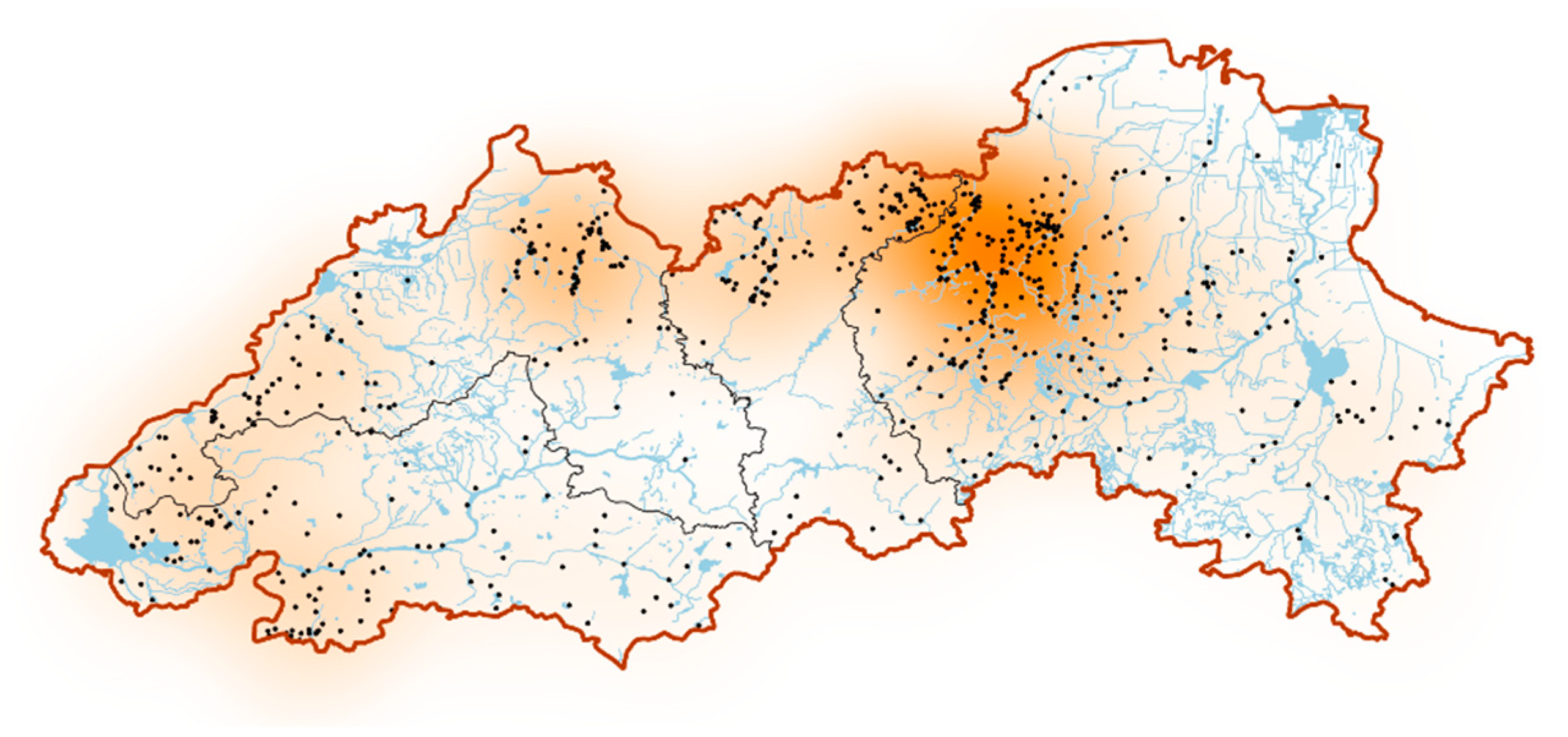
10]. In the kernel density analysis, during the first construction peak, the Neolithic Age, the density of the settlement distribution in western Weifang increased significantly (
Figure 2), covering eastern and northern Qingzhou, southwestern Shouguang, and northern Changle. The settlements in the region were mainly distributed in the middle reaches of the Mi River, the upper reaches of the Dan River, the Yang River basin, and on the diluvial platforms between rivers.
The Shang–Zhou period was the second peak of construction. The density of the settlement distribution in the northern foothills of the Taiyi Mountains increased significantly during this period (
Figure 3), forming a continuous state in western Weifang, northern Zibo, and eastern Jinan. Settlements were mainly distributed in river basins, such as those of the Mi River and the Xiaofu River, as well as in the diluvial platforms and alluvial plains between rivers. Meanwhile, there was a slight increase in density in the southwestern part of the Luzhong region.
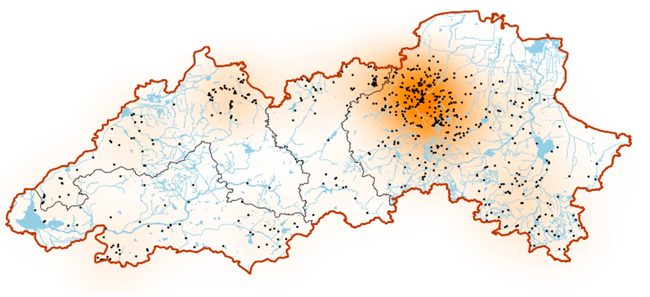
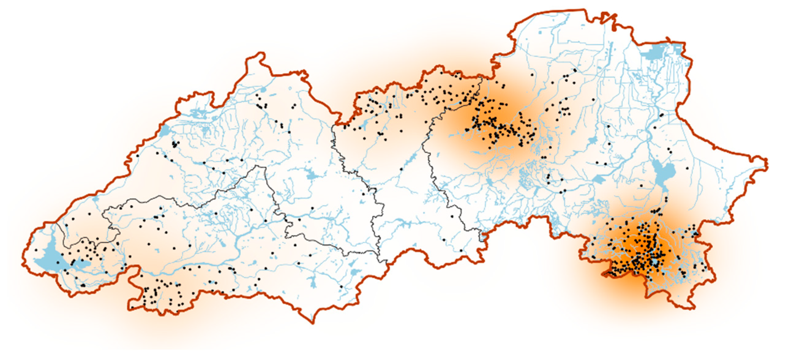
The last peak of construction was during the “Qin–Northern and Southern Dynasties” period, and the distribution of settlements in the Luzhong region was characterised by a double centre (
Figure 4). The first centre was located in the western part of Weifang and in the northeast of Zibo, covering Zhoucun, Linzi, and Qingzhou, with settlements mainly in the Xiaofu River Basin, the middle reaches of the Mi River, and the upper reaches of the Dan River, as well as in the flooded terraces and alluvial plains between rivers. The second centre was located in the southeast of Weifang, in the Zhucheng area, and the settlements were mainly distributed in the Wei River Basin.
3.2. Settlement Distribution in Relation to the Natural Environment
In the development of the settlement, it was first and foremost closely linked to the natural geographical environment. It cannot be separated from the favourable conditions provided by the environment, but is also subject to various restrictions imposed by it. Therefore, this section uses GIS to perform elevation, slope, aspect, and buffer zone calculations to explore the distribution characteristics and evolutionary features of settlements.
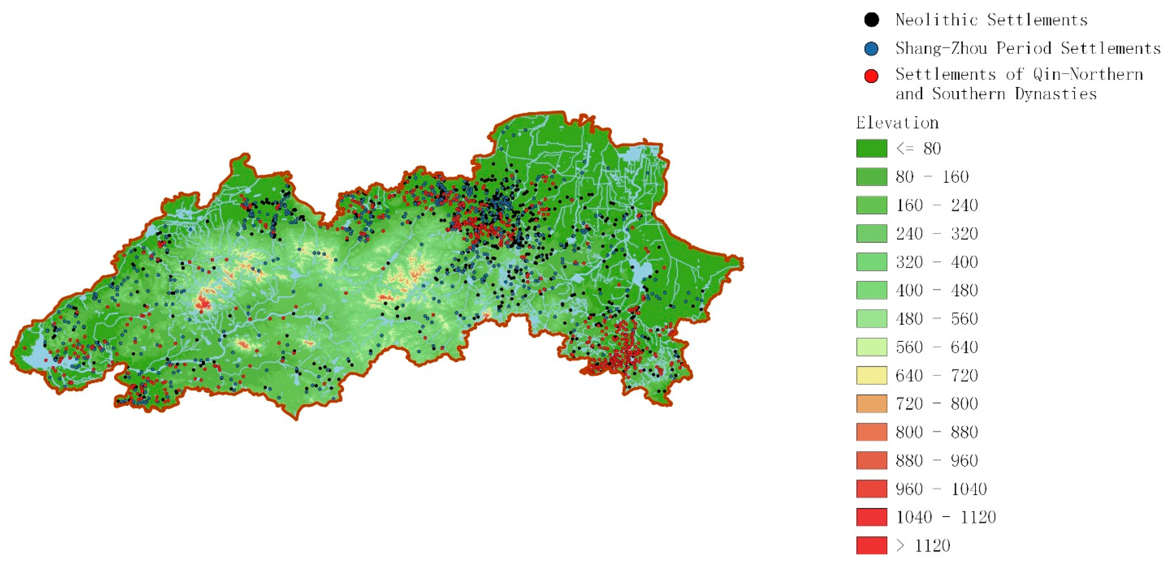
The DEM data were overlaid with settlement points to produce maps of the settlement’s elevation, slope, aspect, and buffer zone distribution (
Figure 5,
Figure 6,
Figure 7 and
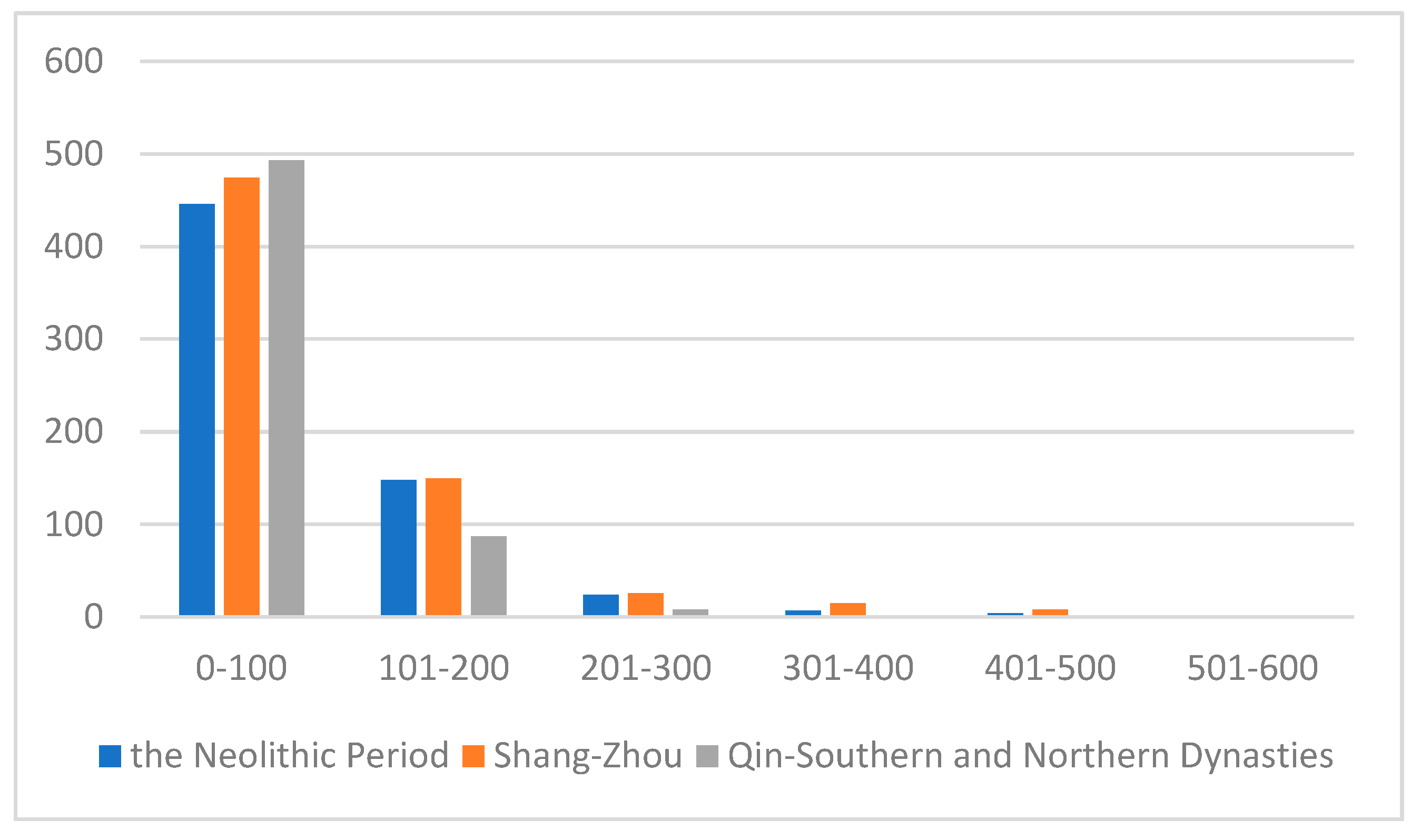
Figure 8). Based on the elevation calculation and statistics, it shows that neolithic settlements were mainly distributed below 200 m above sea level, and 71.3% of the settlements were located between 0–100 m (
Figure 5,
Table 2). There were only scattered settlements in other elevation intervals. During the Shang and Zhou periods, settlements were still mainly distributed below 200 m above sea level, but the altitude range of distribution was expanded, and the number of settlements distributed in higher-altitude areas increased significantly, even reaching up to 868 m. During the period of “Qin to Northern and Southern Dynasties’, the distribution of settlements contracted to lower altitudes and was mainly concentrated in the 0–100 m altitude range, with the number of settlements in this range reaching 83.6%.
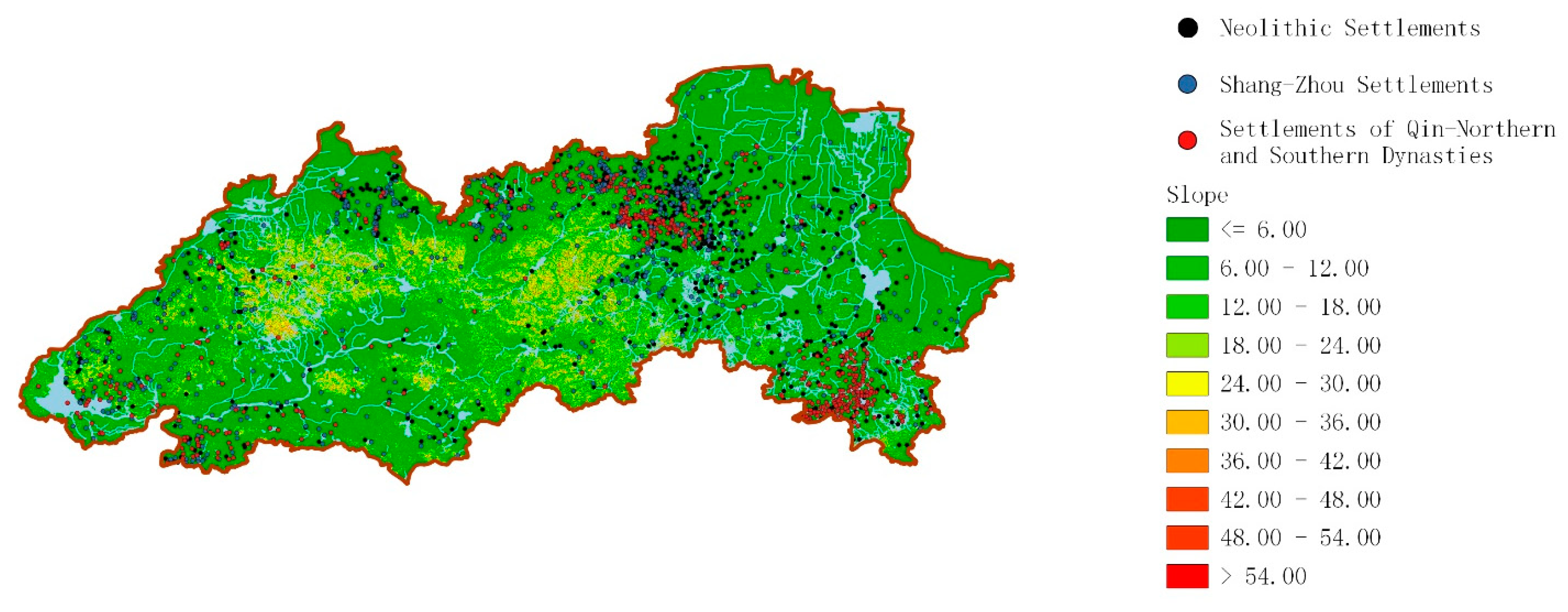
The slope and aspect refer to the spatial orientation and inclination of the local surface slope. The magnitude of the slope directly affects the scale and intensity of surface material flow and energy conversion. The greater the slope, the greater the likelihood of mudslides and landslides [
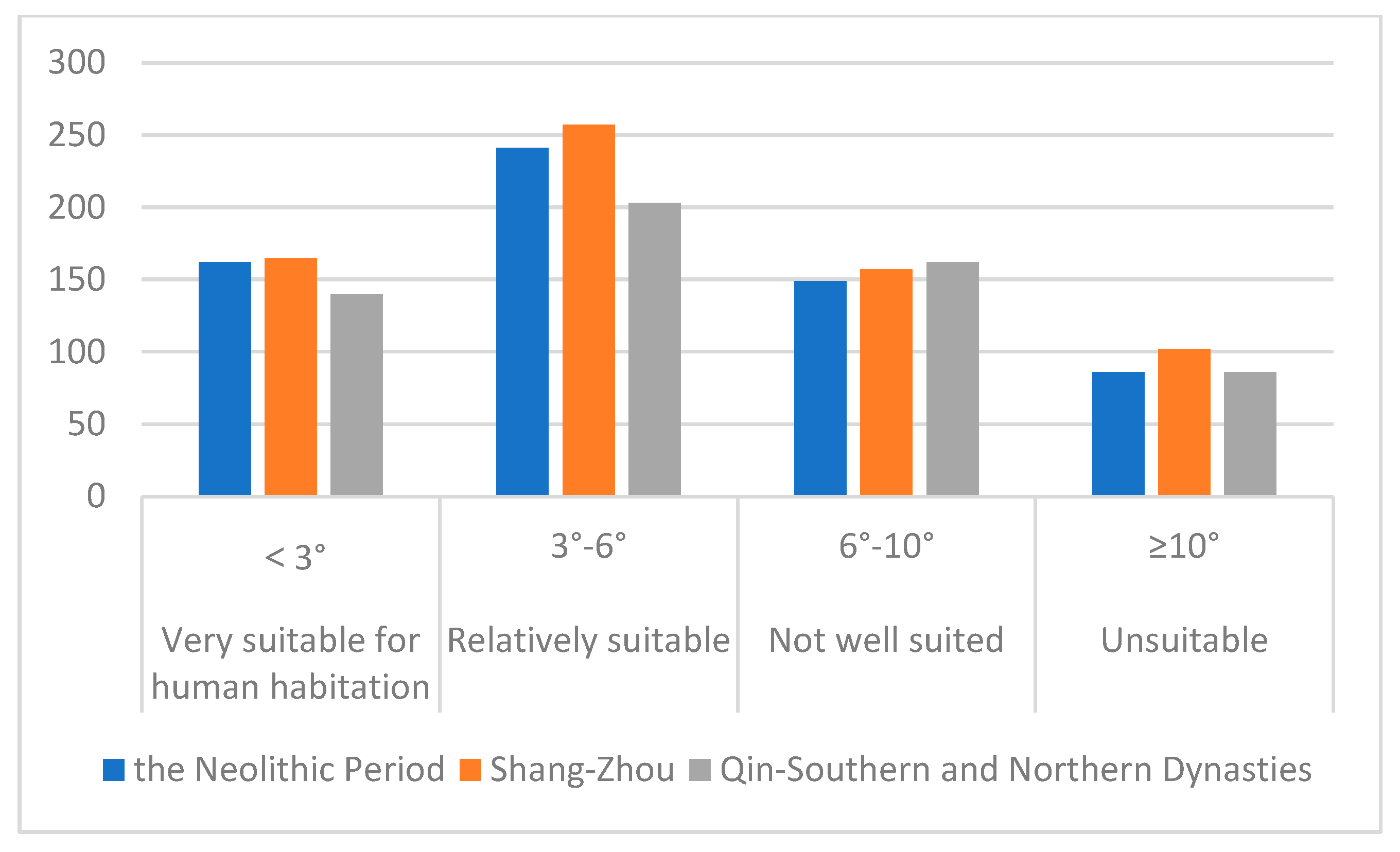
11]. In the statistics and analysis of the slope, this study uses the following grading: a slope less than 3 degrees is very suitable for human habitation, a slope from 3°–6° is relatively suitable for human habitation, and a slope from 6°–10° is not well suitable for human habitation (
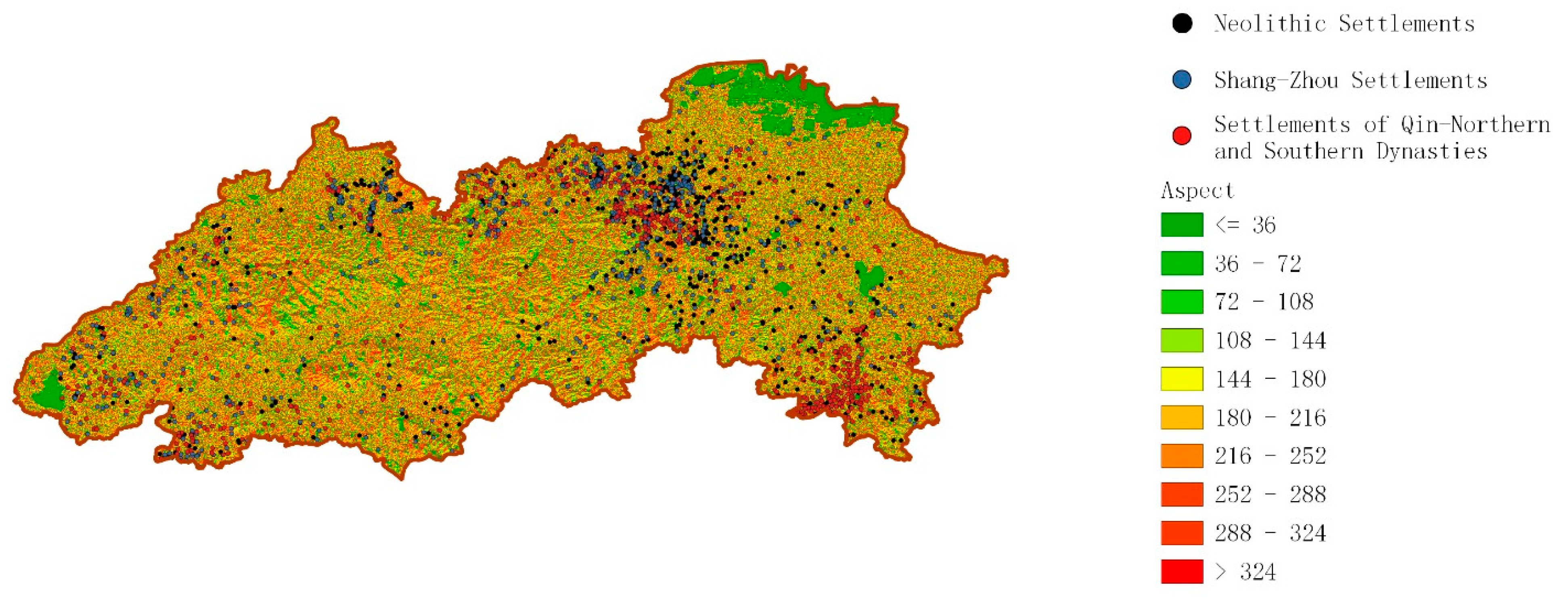
Table 3). The study found that the number of settlements in the “very suitable” and “relatively suitable” zones was high, with the sum of the two zones accounting for 63.2%, 61.9%, and 58% of the total number of settlements in the three periods. At the same time, there are a considerable number of settlements in the “not well suited” zone in each period, while the number of settlements in the “unsuitable” zone is relatively small. The aspect is one of the important factors that determine the local reception of sunlight and redistribution of solar radiation on the surface of the earth, directly causing local differences in climate characteristics [
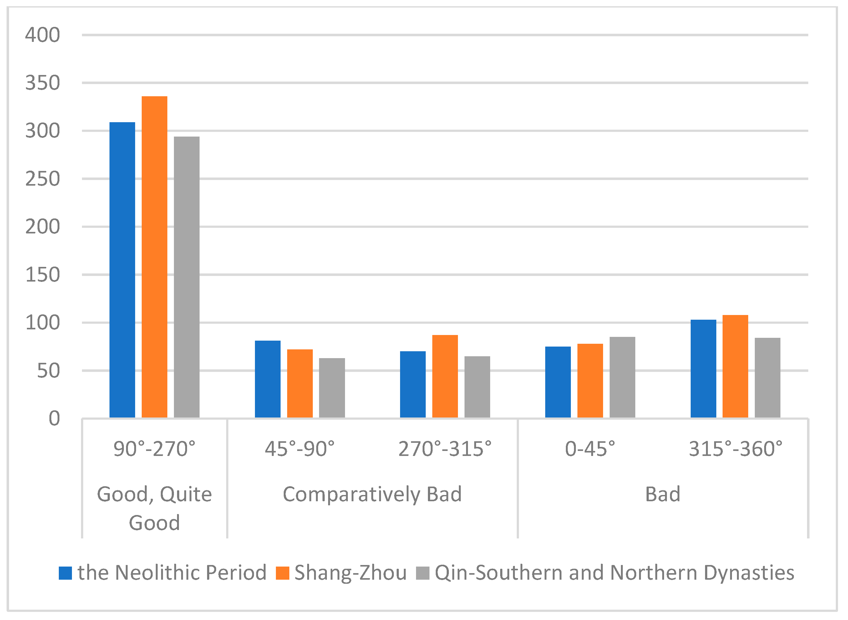
11]. In the calculation of the slope’s direction, the value is taken as 0–360°, with due north as 0 and increasing clockwise. The study defined 90°–270° as good and quite good light, 45°–90° and 270°–315° as comparatively bad light, and 315°–360° and 0–45° as bad light. According to the distribution and statistics of settlements on the slope direction in different periods (
Figure 7,
Table 4), it is found that settlements are mainly distributed in the 90°–270° interval with good and quite good light, and the percentage of the number of settlements in this interval in each period is 48.4%, 49.3%, and 49.7%. The proportion of data remains stable and shows a slight upward trend. The number of settlements distributed in other intervals is low, with 23.7%, 23.4%, and 21.7% of settlements distributed in the comparatively bad interval in different periods, while 27.9%, 27.3%, and 28.6% of settlements were distributed in the bad interval in three periods.
As rivers were the lifeline for early human survival and development, the relationship between settlements and rivers also needs to be fully considered. Through the calculation and statistics of the buffer zone (
Figure 8,
Table 5), there were 313, 311, and 309 settlements distributed within the 1000 m buffer zone of rivers in the Neolithic, Shang and Zhou, and Qin to Northern and Southern Dynasties periods, respectively. This number would be further increased if the tributaries of the river were included in the statistics.
3.3. Settlement Distribution Dominated by Different Elements
In the process of settlement development, the dominant elements gradually became complicated. This section explores the distribution characteristics and evolutionary features of settlements by combining the distribution of settlements with the historical background and dominant cultural forms in which the settlements were located.
According to the above analysis, the Neolithic settlements were distributed in large numbers in the eastern part of the Taiyi Mountains. Specifically, they were concentrated in the flooded terraces and alluvial plains at the northeastern end of the mountains, forming a distinct centre. The formation of the monocentre was mainly influenced by both the geographic environment and the climate. The flooded terraces and alluvial plains in the western part of Weifang were flat and suitable for cultivation, and the higher terrain was protected from flooding, so the natural environment showed strong stability. Thus, it became an ideal place for ancient people to flourish and accumulate a large number of settlements. Other areas had fewer settlements due to their different environmental and climatic conditions. For example, the western part of the Luzhong region is low-lying and has little space for detouring compared with other regions. As for the environment and climate in that period, on one hand, the climate was warm and humid, with abundant precipitation and high river flows; on the other hand, the relatively high sea level caused a lowering of the specific drop of rivers entering the sea and an increase in water levels [
12]. The dual influence of the climate and sea level caused the low-lying areas to be waterlogged, and flooding disasters were frequent. Therefore, these areas were not suitable for human survival, and the number of settlements was small.
The analysis of the settlements in the Shang and Zhou period shows that the main distribution of settlements in the Luzhong area was concentrated at the northern foot of the Taiyi Mountains, west to Zhangqiu, and east to the Neolithic centre. On the basis of the centre of the Neolithic settlements, a continuous belt was formed. In addition, a large number of settlements were also concentrated in the southwestern part of the Luzhong region. The reasons affecting the distribution of settlements at this stage were not only physical geography, but also economic geography and geopolitical structure. After 5 ka. B.P., the climate became less warm and humid, but remained relatively mild until 4 ka BP. The frequency of arboreal pollen decreased while that of pollen for the drought-tolerant plants such as Artemisia and Chenopodiaceae increased in northwestern Shandong. In addition, no remains of Chinese alligator have been discovered in the sites during the late Dawenkou—Longshan cultural stage. It showed that the climate had a cooling and drying trend [
12]. This trend became even more prominent around 4 ka BP. This was clearly recorded in the sediments of the northwestern Shandong Plain [
13], the central Shandong Province [
14], and the Yishu River Basin [
15]. After 3.5 ka BP, the climate fluctuated slightly, but generally stabilised with a mild and dry character. The evolutionary trends in the paleoclimate of the Shandong region are consistent with those of China’s paleoclimate [
16], but differ in specific years due to geographical characteristics. In the western plains, due to the lowering of the sea level and the drying of the climate, the natural environment of the low-lying areas, which was previously unsuitable for human existence, improved, and these areas were gradually exploited on a large scale. In addition, the development of the east–west avenue that formed at the northern foot of the Taiyi Mountains [
17] likewise promoted the development of settlements. Meanwhile, with the retreat of the sea, the distribution of settlements rapidly advanced northward. The elevation analysis of the settlement distribution also shows that the lowest elevation of the settlement distribution is below 1 m, or even close to 0 m. The large number of settlements distributed at the western end of the Taiyi Mountains was mainly influenced by the geopolitical structure on the basis of its geographical conditions. This area was the closest to the central area of the Shang Dynasty, so the distribution of settlements was quite dense [
18].
From the Qin Dynasties to the Northern and Southern Dynasties, two centres of settlement distribution were formed at the northern foot of the mountain range and in the Zhucheng area. Compared with the previous period, the continuity and changes were equally obvious. The continuity was that the settlement distribution centre at the northern foot of the mountain range continued. The first thing that changed was a reduction in the concentrated distribution in the northern foothills of the mountain range; settlements in the west decreased compared to the previous period. More importantly, there was a new centre in Zhucheng. The formation of the new centre was influenced by various factors, such as the natural environment, humanities, and politics. During the Shang and Zhou Dynasties, Zhucheng was located at the border of two countries for a long time; in the Spring and Autumn period, the northern part belonged to Qi and the southern part to Lu; in the Warring States period, after Chu destroyed Lu, most of Zhucheng belonged to Qi [
19]. The location of the border and the frequent wars restricted the development of regional settlements. According to historical documents, in 219 BCE, the First Emperor of Qin ‘moved 30,000 households under the Terrace’ [
20]. If each household had only three people, there would be nearly 100,000 people. The population growth brought about rapid local development, and the number of settlements rose, forming a distinct centre.
4. Discussion
From the above analysis, we can see that there was human activity in the Luzhong area in the Stone Age, and a large number of settlement construction activities began in the Neolithic period. The Neolithic period, the Shang and Zhou period, and the Qin to Northern and Southern Dynasties period were the three high points of the development of settlements. In these three periods, the centres of the large-scale distribution of settlements changed from a “single centre” to a “continuous belt” to a “double centre”. By the time of the “Qin to Northern and Southern Dynasties” period, the settlement system in the Luzhong region had been formed, and the cities, towns, and villages of today were basically developed on this basis. At the same time, under the construction policy of “strong trunk and weak branches” of the central government, the construction of habitats in Shandong began to be reduced [
18]. Since then, most of the existing settlements were inherited and only sporadically built. From the perspective of the whole country, the interactions between the settlements in the Luzhong region and the surrounding areas grew from a strong position in the early days [
6], gradually developing into the country system [
18], and becoming one of the most important components of Chinese civilisation. The ancient settlements in the Luzhong region showed continuous development over time, and spatially, they show the characteristics of a main body continuing local changes.
Based on the calculation and statistics concerning the elevation, slope, aspect, and buffer zone, it was found that most of the settlements in different periods were located below 100 m in elevation (
Figure 9), and based on further detailed analysis of the 0–100 altitude interval, the settlements were mainly concentrated in the 20–60 m interval. With the retreat of the sea and improvements in technology, the settlement distribution expanded to the sea, on the one hand, and the lowest elevation of the site distribution in the Shang and Zhou periods reached 1 m or even approached 0 m. On the other hand, the distribution also expanded to higher elevations. Human settlements also appeared at elevations of 700–900 m in the Shang and Zhou periods. On the whole, the distribution of settlements was gradually reduced by the limitations on altitude, and the distribution gradually spread more widely. In terms of slope, settlement sites tended to be chosen in flat areas with slopes of less than 6°, and more than 50% of the settlements in all periods were located in such zones (
Figure 10). The flat areas allow for easy access to travel, water, and agricultural production. The fact that the number of settlements in the 3°–6° slope interval is greater than in the flattest interval should be the result of a combination of factors, such as distance from water sources, slope direction, altitude, etc. Although ancient people preferred to live on flat terrain, some still chose to survive on sloping areas in order to survive because of the limited resources available on flat terrain. In contrast, settlements are still found in areas with slopes ≥10° or even >20°, which should be related to military or defensive functions. In terms of the aspect, the number of settlements located in the good and quite good light intervals was significantly higher than that in the bad and comparatively bad intervals in all three periods (
Figure 11). It is therefore inferred that the choice of site for the settlement is strongly influenced by the direction of the slope, and that more settlements will choose to face south or as far south as possible. The south-facing slopes are less exposed to the cold northwesterly winds and receive more light in the cold winter months. More importantly, the south-facing slopes will be more vegetated due to the abundance of sunlight, which means they can provide more food resources than poorly lit slopes and are more suitable for human survival. The analysis of the buffer zone found that the proportion of settlements located within the buffer zone remained at around 50% in all three periods, indicating a high demand for a relatively stable water system.
5. Conclusions
This study constructed a geographic information database of ancient settlements in the Luzhong region and mapped the dynamic overlay of the spatial–temporal distribution of these ancient settlements, in addition to visualising the historical distribution information of ancient settlements in the region. The database contains information on key attributes of the settlements in the region, providing a solid foundation for further research and practice. The map helps to build a historical context for the development of settlements in the Luzhong region and deepens the understanding of the development of traditional settlements in ancient China. Through the analysis of data on nearly 2000 settlements, the spatial and temporal distribution patterns of ancient settlements in the Luzhong region were derived; the development of ancient settlements in the region experienced three peaks of settlement construction during the Neolithic period, the Shang and Zhou periods, and the Qin to Northern and Southern Dynasties period. The distribution centres of the settlements experienced changes from a “single centre” to a “continuous belt” and to a “double centre”. In different periods, the settlements were mainly distributed in alluvial plains with elevations below 100 m and with a flat topography (slope < 6). They also presented the characteristic of living by water. The settlements in the Luzhong region continuously developed over time, and the spatial development showed the characteristics of continuous local changes in the main body. Through an understanding of the distribution, morphology, and development of ancient settlements in the Luzhong area, we can glimpse settlement development in the core region of Chinese civilisation.
This study integrated the research methods of habitat and environmental science, archaeology, and cultural geography. It also used quantitative analysis tools, such as GIS, to analyse the spatial and temporal distribution and morphological characteristics of ancient settlements in the Luzhong region. The comprehensive investigation and systematic sorting of the spatial–temporal distribution of ancient settlements in the Luzhong region can enrich case studies of settlements and provide theoretical support for the conservation of the related cultural heritage. At the same time, as they are the predecessors to today’s cities, towns, and villages, the study of these settlements also sheds light on the planning and construction of contemporary human settlements. In addition, the distribution of settlements in different periods is an important reflection of the interactions between people and places in the region. The study of the spatial–temporal distribution of ancient settlements in the Luzhong region can help to form a systematic understanding of the trends in the formation and development of the spatial system in the area in order to further explore the harmonious development of human–land relations and build sustainable cities and communities.
Author Contributions
Conceptualisation, M.T. and B.L.; methodology, B.L.; software, M.T.; validation, M.T., B.L. and Z.L.; formal analysis, M.T.; investigation, Z.L.; resources, M.T.; data curation, M.T.; writing—original draft preparation, M.T.; writing—review and editing, B.L. and Z.L.; visualisation, M.T.; supervision, Z.L.; project administration, B.L.; funding acquisition, Z.L. All authors have read and agreed to the published version of the manuscript.
Funding
This research received no external funding.
Data Availability Statement
Not applicable.
Conflicts of Interest
The authors declare no conflict of interest.
References
- Gao, L.B. New Means of Spatio-temporal Interpretation-History, Present and Future of Archaeological GIS Research in Europe and America. Archaeology 1997, 38, 89–95. [Google Scholar]
- Chen, R.; Li, F.Q.; Wang, T.Y.; Zhu, L.D.; Ye, W.; Zhou, G.C. The Size Distribution of Neolithic Sites in the Middle Reaches of the Yangtze River. Acta Geogr. Sin. 2018, 73, 474–486. [Google Scholar]
- Ren, Y.Q.; Jin, J.H.; Zuo, X.X.; Huang, Y.M.; Li, Z.Z. Spatial and Temporal Distribution of Prehistoric Settlement Sites in Minjiang River Basin and Their Relationship with Environmental Factors. J. Earth Environ. 2021, 1, 68–83. [Google Scholar]
- Liu, L.; Liu, F.; Zhang, W.; Xu, Z. Spatial Distribution and Evolution of Ancient Settlements from the Neolithic to the Bronze Age in Dalian Area, China. Front. Earth Sci. 2022, 10, 917520. [Google Scholar] [CrossRef]
- Wang, F.; Yang, X.L.; Yang, Z.P.; Luan, F.M.; Xiong, H.G.; Wang, Z.G.; Zhao, X.Y.; Qin, W.M.; Wu, W.J.; Li, D. Spatiotemporal Characteristics of Cultural Sites and Their Driving Forces in the Ili River Valley during Historical Periods. Acta Geogr. Sin. 2015, 70, 1089–1108. [Google Scholar] [CrossRef]
- Tong, P. A Retrospect and Prospects of Shandong Archaeology at the turn of century. Archaeology 2000, 41, 877–890. [Google Scholar]
- Shandong Provincial Information Database. Available online: http://lib.sdsqw.cn/bin/mse.exe?seachword=&K=a&A=4&rec=103&run=13 (accessed on 3 September 2022).
- State Administration of Culture Heritage. Atlas of Chinese Culture Relics: Shandong Volume; China Map Press: Beijing, China, 2006. [Google Scholar]
- Information on Immovable Cultural Relics. Available online: www.ncha.gov.cn/col/col2266/index.html (accessed on 11 August 2022).
- Jiang, Y.; Li, W.J.; Liao, B.G.; Li, X.D.; Yu, J. Open Source GIS QGIS Spatial Analysis Tutorial; Science Press: Beijing, China, 2021. [Google Scholar]
- Bi, S.B.; Guo, W.Z.; Lv, G.N. Aspect and Slope Analysis of Prehistoric Settlement Sites in Zhengzhou-Luoyang Region. Sci. Surv. Mapp. 2010, 35, 139–141. [Google Scholar]
- Guo, Y.Y.; Mo, D.W.; Mao, L.J.; Wang, S.G.; Li, S.C. The Relationship between Settlements Distribution and Environmental Changes from the Neolithic to Shang-Zhou Periods in North Shandong Province. Acta Geogr. Sin. 2013, 68, 559–570. [Google Scholar]
- Xu, Q.H.; Wang, Z.H.; Wu, C. The Vegetation and Environment of the Northern Shandong Plain since 30kaB.P. In Quaternary Comparative Study of Land and Sea in China; Liang, M.S., Zhang, J.L., Eds.; Science Press: Beijing, China, 1991; pp. 188–199. [Google Scholar]
- Ding, M.; Peng, S.Z.; Pang, J.L.; Zhang, W.; Chen, D.D.; Yang, H.J. Holocene Environmental Change and its Impacts on Cultural Development in the Central Region of Shandong Province. Chin. J. Soil Sci. 2011, 42, 1281–1287. [Google Scholar]
- Gao, H.Z.; Zhu, C.; Cao, G.J. Environmental Archaeology on the Rise and Decline of Ancient Culture around 2000 BC in the Yishu River Basin. Acta Geogr. Sin. 2006, 61, 255–261. [Google Scholar]
- Qin, Z. Exploring the Early Anthropocene: Implications from the Long-term Human–climate Interactions in Early China. Mediterr. Archaeol. Archaeom. 2021, 21, 133–148. [Google Scholar]
- Hou, R.Z. Theory and Practice of Historical Geography; Shanghai People’s Publishing House: Shanghai, China, 1979. [Google Scholar]
- Zhang, Y. A Historical Study on the Physical Pattern and their Construction of Early Chinese Human Settlements in the Hai-Dai Region (of East China) During the Period of Pre-Qin (before 221 B.C.). Doctoral Dissertation, Tsinghua University, Beijing, China, 2002. [Google Scholar]
- Li, G. Study on the Urban Geography of Shandong Peninsula–Centering on the Evolution of Urban Groups and Central Cities from Western Han to Yuan. Doctoral Dissertation, Fudan University, Shanghai, China, 2008. [Google Scholar]
- Sima, Q. Records of the Historian; Zhonghua Book Company: Beijing, China, 2019. [Google Scholar]
| Publisher’s Note: MDPI stays neutral with regard to jurisdictional claims in published maps and institutional affiliations. |
© 2022 by the authors. Licensee MDPI, Basel, Switzerland. This article is an open access article distributed under the terms and conditions of the Creative Commons Attribution (CC BY) license (https://creativecommons.org/licenses/by/4.0/).


