Article

Small Cultural Forests: Landscape Role and Ecosystem Services in a Japanese Cultural Landscape

Department of Agriculture, Food, Environment and Forestry (DAGRI), University of Florence, via San Bonaventura 13, 50145 Florence, Italy
*
Author to whom correspondence should be addressed.
Land 2022, 11(9), 1494; https://doi.org/10.3390/land11091494
Submission received: 18 July 2022 / Revised: 31 August 2022 / Accepted: 2 September 2022 / Published: 6 September 2022

Abstract

:
Small woods, linear tree formations, or scattered trees in agricultural areas are receiving increasing attention for their multifunctional role, especially if associated to cultural landscapes. Osaki Kodo’s Traditional Water Management System for Sustainable Paddy Agriculture represents one of the most important cultural landscapes (satoyama) of Japan, also included by the FAO in the GIAHS (Globally Important Agricultural Heritage Systems) Programme. Here, local farmers surrounded their farmhouses with small woods, called igune, as a protection from the cold winter wind, creating a peculiar landscape characterized by an intensively cultivated plain dotted with small wood patches. The research aims at deepening the knowledge of igune, evaluating the landscape role and monitoring their changes in the last 20 years, through multitemporal and spatial analyses. In addition, a literature review has been performed to assess other Ecosystem Services (ESs) provided by igune within the study area. Despite the limited overall surface, 1737 igune and small woods currently characterize the area, with 72% of them having a surface smaller than 0.5 hectares. The multitemporal and spatial analyses show that their number, distribution, and spatial pattern remained almost completely unchanged in the last 20 years, testifying their key role in characterizing the local cultural landscape. Least-Cost Path analysis highlighted a crucial role in connecting the two forest nodes of the region, as 90% of the path passes inside more than 70 different igune and small woods. Literature review demonstrated that igune and other small woods still provide various ESs, including ecological network, habitat for various flora and fauna species, firewood, and byproducts, as well as cultural services. This maintenance of the traditional management in cultural forests is crucial not only to retain their landscape role, but mostly for the preservation of the related ESs, as changes in the management can lead to changes in horizontal and vertical structures, and in species composition.

1. Introduction

Cultural landscapes are receiving increasing attention in the last decades, both at the scientific and the institutional level, thanks to their multifunctional role. The introduction of the term cultural landscape in scientific research dates back to 1925, when the American geographer Carl Sauer wrote that ‘‘a cultural landscape is fashioned from a natural landscape by a culture group. Culture is the agent, the natural area the medium, the cultural landscape the result’’ [1], recognizing the role of culture in shaping the land. The links between cultural values, biodiversity, and landscape have been later addressed by different institutional initiatives. In 1992, the UNESCO World Heritage Convention became the first international legal instrument to specifically recognize and protect cultural landscapes, with the inclusion of the category of “cultural landscapes” within the World Heritage List, describing them as representative of the “combined works of nature and of man”. More recently, the European Landscape Convention, signed in 2000, defined landscape as “an area as perceived by people, whose character is the result of the action and interaction of natural and/or human factors”, highlighting the key role of the human and cultural factors [2]. At the European level, in 2003, the Ministerial Conferences on the Protection of Forests in Europe (MCPFE), now called Forest Europe, released the Vienna Resolution n. 3 during the 4th MCPFE Conference, representing a decisive step towards the inclusion of social and cultural values in Sustainable Forest Management [3]. In the following years, the combined work of the IUFRO, Austrian Forest Association, US Forest Service, United Nation Forum on Forests, Council of Europe, UNESCO WHC, and Groupe d’Historie de Forets Francaises led to the publication of the Sustainable Forest Management Guidelines, presented in 2007 at the MCPFE conference in Warsaw, which included the cultural values as a crucial issue to be taken into consideration by national forest programs and rural development plans for Sustainable Forest Management [4]. The role of cultural values in landscape management and planning, as well as for biodiversity conservation, is also the subject of a joint program between UNESCO and the Convention on Biological Diversity (CBD) signed in 2010 [5].
Cultural landscapes can provide multiple benefits and Ecosystem Services (ESs), both for the local communities and for the local environment, including supply of food and byproducts, protection of water, soil and soil fertility, preservation of biodiversity, as well as representing habitats for flora and fauna species. In addition, they can represent touristic destinations, or they can contribute to strengthening the cultural identity of local communities [6,7,8,9]. One of the most important initiatives undertaken at the international level related to cultural landscapes and to traditional agricultural systems is the GIAHS (Globally Important Agricultural Heritage Systems) Programme, established by the Food and Agriculture Organization (FAO), whose aim is to identify and preserve agricultural systems of global importance with their landscapes, biodiversity and agrobiodiversity, traditional knowledge, and associated culture [10]. The traditional activities carried out in these sites by generations of farmers and shepherds produced sustainable agricultural heritage systems, but also shaped the land to adapt to various and often difficult environmental conditions, creating unique cultural landscapes [11]. Among the GIAHS sites (62 systems in 22 countries are designated as GIAHS sites as of June 2022), many are based on forests or agroforestry systems, as these systems always played a fundamental role for rural communities, providing multiple products and services, often corresponding to a sustainable and integrated management between agriculture and forests [12]. This functional interrelation between agricultural and forest activities is increasingly important, especially considering the context of northern hemisphere countries, where rural areas are more and more affected by urban sprawl around big cities [13], by the growth of agricultural monocultures, or by the disappearance of traditional agroforestry activities in marginal areas [14].
Unfortunately, there still is a significant lack of scientific research about the effective importance of these traditional systems, especially concerning the issues related to cultural landscape characterization, assessment and preservation, but also considering the different interrelated topics (food security, biodiversity, landscape, traditional knowledge, socioeconomic assessments, etc.), as most of the published research focuses only on one or two topics [15]. Therefore, it is important to increase the scientific knowledge of these traditional systems by assessing and identifying all the related ESs in order to contribute to their preservation, but also because they represent effective examples of sustainable practices and territorial management that can provide solutions to be replicated in other parts of the world in relation to global challenges such as climate, food security, and socioeconomic changes.
One of the best examples of a GIAHS site where the traditional agroforestry system is still crucial for the landscape conservation, for the wellbeing of the local community and for the environmental services, is the one called Osaki Kodo’s Traditional Water Management System for Sustainable Paddy Agriculture, located in Miyagi Prefecture, Japan. Here, local farmers had to adapt to difficult environmental conditions, as most of the area was originally occupied by swamps and wetlands and the region frequently experienced periods of drought alternated to periods of floods. Therefore, an extensive system of channels was built to allow rice cultivation in the plain area, and farmers had little choice but to build houses on slightly elevated terrain surrounded by rice paddies. On the other hand, living in an open area that was originally a floodplain entailed the risk of exposure to the north-westerly winter wind, called yamase, that caused the rapid decrease in temperatures and damages to cultivations. Local farmers succeeded in reducing the effects of the cold wind by surrounding their farmhouses with small woods, called igune [16]. The historical relevance of igune is already attested from the 17th century; the Sendai Domain (1600–1868 A.D.), an historical region which includes the current GIAHS site, placed great importance on maintaining igune. Lord Date Masamune, who ruled the Domain from 1600 to 1636, established that farmers would only be allowed to cut down trees by permit from the Domain, as a measure against floods. Farmers were required to plant a certain number of saplings to replace the original tree, in accordance with the size of the trunk of the cut tree. In addition, he promoted plant nurseries in 17 locations within the Domain to grow saplings to be used for reforestation. Thanks to these historical conservation measures, igune started to spread across a wide area within Sendai Domain, as testified also by the “Arakawa-zeki Ezu” drawn in 1858, showing almost all the local farmhouses surrounded by igune.
Small patches made of tree cover vegetation, despite different typology, name, and definition (small woods, Trees Outside Forests, riparian vegetation, linear tree formations, island forests, etc.), represent important microhabitats and an essential component of many ecological networks in different landscapes and environments, often connecting big forest patches [17]. Measuring and mapping connectivity at the landscape level is more and more important, as the loss of connectivity is recognized to be a major threat to biological diversity, considering that it can affect the size and quality of habitats, impede or disturb movements to new habitats, and/or disturb seasonal migrations [18,19,20,21,22]. In heavily human-modified landscapes, land use changes may shrink the amount of a habitat or fragment it into smaller or differently arranged patches. Therefore, it is important to survey the different features of the landscape structure that can act as connections between similar habitats, as they can represent the structural connectivity, usually defined by the physical characteristics of a landscape mosaic that permit the movement of individuals or populations, including topography, hydrology, vegetative cover, and land uses [23]. Different approaches and theories can be applied to the evaluation and measurement of the structural connectivity in a given landscape (least-cost analysis, factorial least-cost paths, graph theory, resistant kernel, etc.), but despite the applied methodology, almost all the theories provide maps of core areas, stepping stones, nodes, linkage zones, or barriers that can represent an effective support for local territorial planning [24,25].
In addition, it is also important to highlight the cultural value associated with igune, as they have been created and managed by humans through the centuries for protecting their farmhouse and secondary agricultural products from the cold wind and for obtaining firewood and other byproducts. In a countryside dominated by flat rice paddies, the protection offered by igune to small vegetable gardens located around farmhouses allowed the population to partially overcome the reduced rice production in years when the cold north wind damaged it, as well as supplementing their diet with many varieties of food. Igune are, therefore, strictly connected to the concepts of traditional forest-related knowledge and of cultural forests, which are receiving growing attention at the international level, especially for their links with Sustainable Forest Management (SFM) and for the preservation of cultural identity and of agrobiodiversity [3,4,26,27,28,29,30].
Given these premises and considering that most of the research concerning small woods focused on the ecological and connectivity role or on their importance as biodiversity reservoirs, it is clear that there is a knowledge gap in relation to complete assessments of their capacity in providing different ESs. The main aim of the paper, in fact, is to contribute to reducing this knowledge gap, deepening the knowledge of igune and other small woods in a recognized cultural landscape of Japan. The paper intends to:
(1)
evaluate the current landscape role and monitor the landscape changes affecting igune and other small woods in the last 20 years;
(2)
assess the related ESs through a literature analysis of papers referring to the same study area;
(3)
demonstrate that the iconic features of a cultural landscape can still have multiple roles and offer ESs to the local population, even after centuries.
In addition, the results of this study provide detailed spatial data at the landscape level within a Japanese cultural landscape, also setting a baseline for the future monitoring of these forest formations, which could be of interest for local administrations and planners, as well as for the GIAHS Secretariat.

2. Materials and Methods

2.1. The Study Area

The study area corresponds to a portion of the GIAHS site called Osaki Kodo’s Traditional Water Management System for Sustainable Paddy Agriculture, for a total surface of 15,970 hectares, across the territories of Osaki, Kurihara, and Wakuya cities, in Miyagi Prefecture, Japan (Figure 1). The official GIAHS site delimitation has been made following administrative borders; therefore, it also includes main cities and other land uses not directly part of the cultural landscape but indirectly linked to the system. For this reason, it was decided to focus on the portion of the GIAHS site which actually presents the cultural landscape that is the subject of the inscription, excluding other areas such as cities or contiguous forests. The study area is characterized by two big forest patches (nodes) located in the north-west and south-east part. The altitude varies from 0 to approximately 200 m a.s.l., with the two big forest patches corresponding to the places at higher altitude. According to the Köppen–Geiger climate classification [31], the area has a humid subtropical climate (Cfa), with average annual temperature in Ōsaki (the main city) of 11.5 °C, highest average temperature in August (approximately 24.4 °C) and lowest in January (approximately −0.6 °C). The average annual rainfall is equal to 1249 mm. The population of Osaki city remained almost stable from the ’70 s; according to Japanese census data, population in 1970 was equal to 126,057 while the last census of 2020 reported a population of 127,330 [32]. These data refer to all the Osaki city territory, and not only to the study area. In addition, it has to be considered that approximately 20% of the local labor force population is actively involved in agricultural activities [33].

2.2. Methodology

The methodology can be divided into two different parts: (i) multitemporal and spatial analyses for obtaining data about the landscape role of igune and other small woods and for measuring their transformations in the last 20 years, and also for setting a baseline for future monitoring; (ii) analysis of the existing literature of studies conducted in the same study area to assess other ES.

2.2.1. Multitemporal and Spatial Analyses

The first phase of the spatial analysis is based on the identification and mapping of igune and other forest patches inside the study areas to assess the current and the past situation. This has been executed through manual photointerpretation of Google Satellite images of 2002 and 2021 using QuantumGIS (QGIS) software, in order to obtain detailed maps of these small woods and of the two wide forest nodes in the north-west and south-east part of the study area. The 2002 images were taken by Maxar Technologies in the month of October and have a resolution equal to 63 cm, while the 2021 images were taken in December by Planet.com with a resolution less than 50 cm. The second step focuses on the measurement of some simple landscape metrics to evaluate the main dimensional characteristics of igune and other small woods (Table 1) and on the performing of different spatial analyses.
The landscape metrics and spatial analyses have been applied both to 2002 and 2021 to assess the landscape changes that may have affected the igune in the last 20 years. The two maps have been intersected to check the losses and the gains of igune and other small woods. The polygons where igune and other small woods disappeared in the last 20 years have been checked again to identify the new land uses that replaced them and, therefore, to identify the main threats.
The following is the detailed description of the performed spatial analyses.
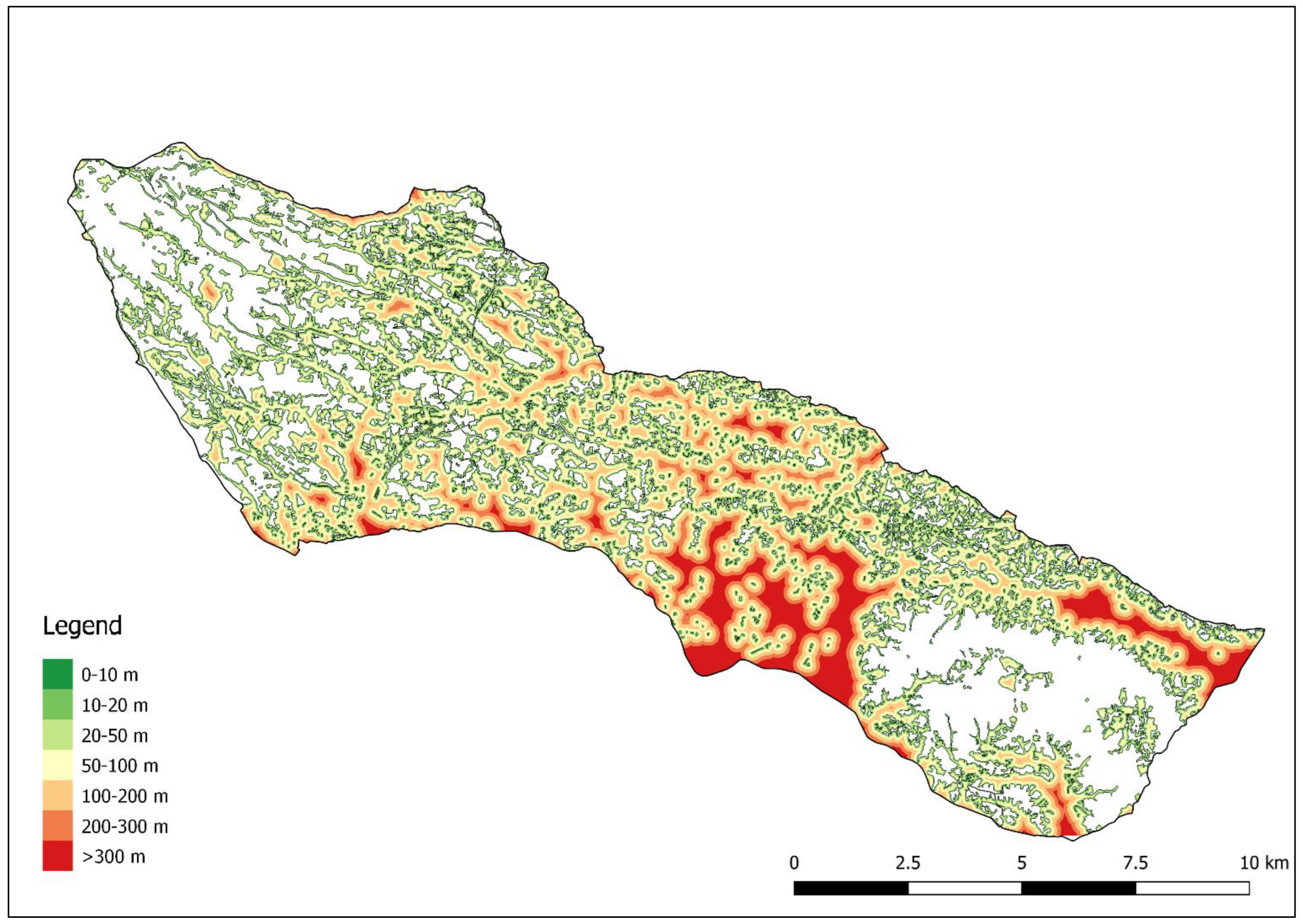
A proximity analysis has been performed through the use of QGIS software and GRASS GIS plugin to identify the average and the maximum distance of each point within the study area from forest nodes, igune, and other small woods. A map of distance from forest nodes, igune, and other small woods has been created, extracting and rasterizing all these patches and then elaborating the dataset with the Proximity (raster distance) QGIS tool. After the exclusion of all the forest nodes, igune, and other small woods patches, the average and the maximum distance have been calculated, and then reclassified in classes to obtain a better visualization on the map. The classes are the following: 0–10 m, 10–20 m, 20–50 m, 50–100 m, 100–200 m, 200–300 m, and above 300 m.
Using the proximity map as a basis (not the one with the distances organized in classes, but the raster with continuous values), a simple Least-Cost Path (LCP) analysis has been performed with Least-Cost Path QGIS plugin, to evaluate the role of igune and other small woods in connecting the two forest nodes. The “cost” for each pixel outside wooded areas has been set to match the distance from them, to find a route that favors small passages outside igune and other small woods and to maintain the path as close as possible to these areas. For pixels inside igune and other small woods, instead, a unique value of 0.1 has been set to allow the software to identify the shortest paths within these patches, without affecting the overall calculation of the path outside them.
To produce maps containing information about the number and the surface of igune and other small forests, a 5-hectare hexagon grid was created using Quantum GIS with the MMQGIS plug-in. The use of hexagons to carry out regular tessellations for landscape structure analysis is due to the fact that this kind of grid can offer different advantages: any given point inside a hexagon is closer to the center of that hexagon than if other shapes (i.e., square or triangle) of the same size would be used; in addition, hexagons are the only geometric shape for regular tessellations that shares a real border with every neighbor [36]. The choice of the size of the hexagon is made on the basis of previous experiences and on the relation with the overall extent of the area, bearing in mind that changes in the extent of the hexagons can lead to different results of landscape metrics [37]. For each hexagon, the number of patches of igune and other small forests totally or partially included and their surfaces in relation to the total surface of the hexagon have been calculated. Obviously, this analysis has been performed excluding the two areas covered by the two large forest nodes. The output includes two different maps (number of patches of igune and other small forests; percentage of surface of igune and other small forests) that could also serve as a baseline for future monitoring.

2.2.2. Literature Analysis

The second part of the applied methodology focuses on an accurate literature analysis to investigate other specific roles and ESs related to the presence of igune and other small woods within the study area. Due to the importance of this location on a historical, cultural, ecological, and social level, it is possible to find some scientific studies explicitly focusing on this area; therefore, the literature analysis has been conducted exclusively on sources referring to the same area (and the same forest patches) used for the spatial and multitemporal analyses. Literature reviews are increasingly used in various research fields to assess the state of the art regarding a specific theme and to identify knowledge gaps to be filled [38,39,40]. The aim of this part of the research, however, is not to apply a standard protocol commonly used in systematic reviews, but to carry out an analysis of all the published papers and scientific reports dealing with igune and other small woods in the same study area. Therefore, a complete literature analysis has been conducted in the months of January and February 2022 searching for igune-related research in all the most commonly used scientific databases (Scopus, Web of Knowledge, ResearchGate). Since most of the studies and reports published about igune and other small woods in the area are not published in international journals, we also considered in our analysis the ones published in Japanese, but with abstracts in English that reported interesting data and information. The fact that many igune-related studies are locally published in Japanese and that arts and humanities studies are poorly represented in scientific databases could represent a limitation of this part of the research. The GIAHS proposal document has represented one of the main sources of information.

3. Results

3.1. Identification and Mapping of Igune and Other Small Woods

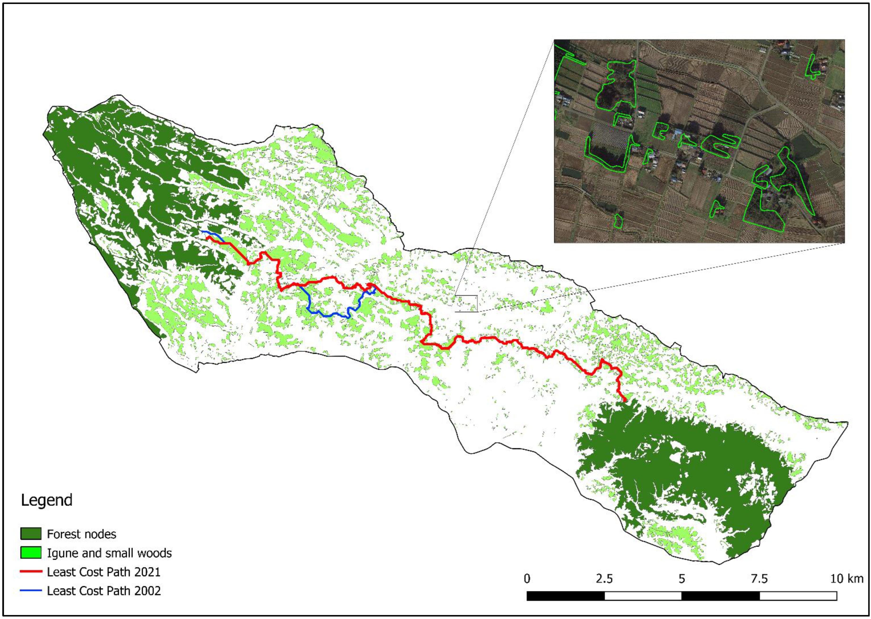
The local cultural landscape is deeply characterized by the presence of a high number of small-medium size patches of igune and other small woods connecting the two big forest nodes, located in the north-west and south-east part of the study area at a distance of approximately 12 km (Figure 2).
In 2002, the area was characterized by 1703 igune and other small woods, for a total extension of 2115.6 ha, with surfaces ranging from 0.012 to 88.32 ha and MPS equal to 1.24 ha. The situation of 2021 is almost the same, with a total number of igune and other small woods equal to 1737, total surface of 2075.5 ha, ranging from 0.012 to 87.85 ha and MPS of 1.19 ha (Table 2).
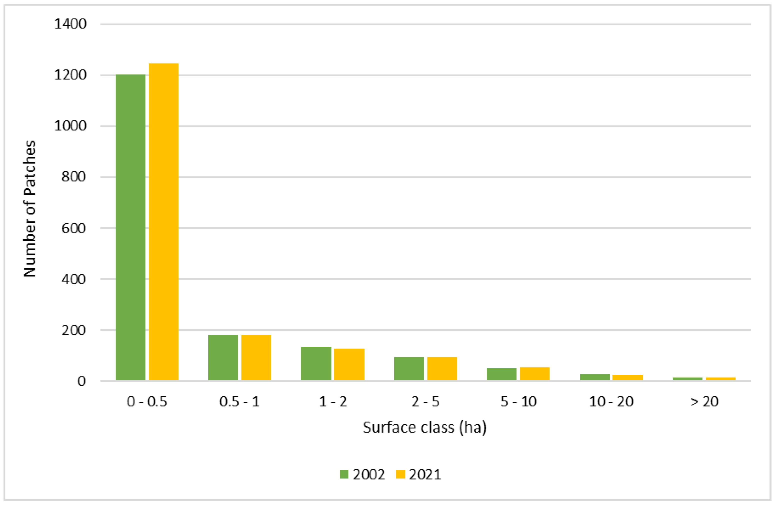
Despite it seeming that there is a great variability in the surfaces of igune or other small woods, it has to be considered that 82% of these patches has a surface smaller than 1 ha, 16% has a surface between 1 and 10 ha and only 2% has a surface greater than 10 ha; the situation is almost the same for 2002 and 2021 (Figure 3). The quartiles analyses confirm that most of these features can be considered of small size (Table 2).
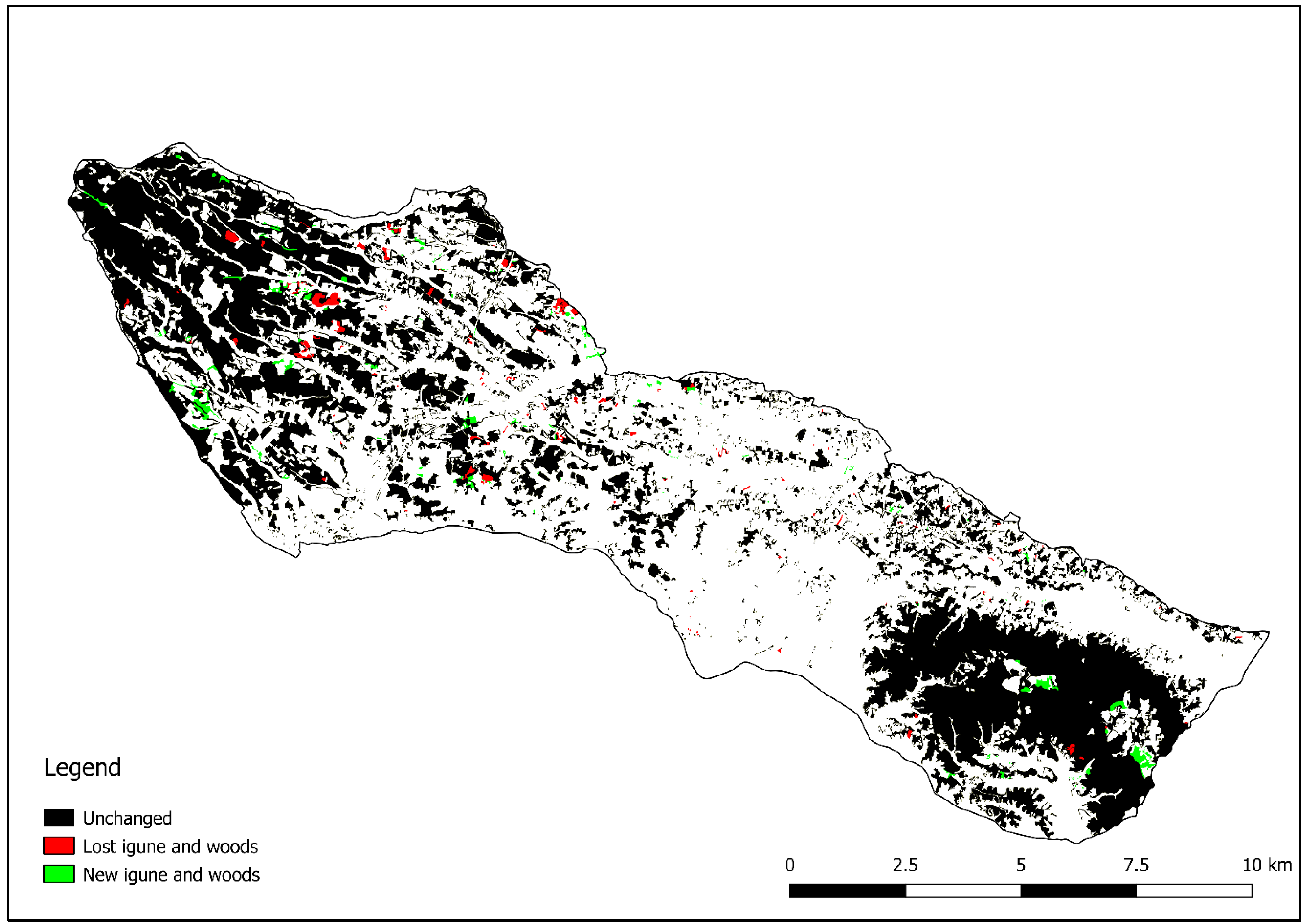
Results of the intersection between the layer of 2002 and 2021 show that 96.4% of igune and other small woods surface remained unchanged regarding the land use classification, and that there is a loss of these features corresponding only to 50.5 ha counterbalanced by an increase of 34.3 ha (Figure 4). Despite igune and other small woods suffered only a very small surface decrease in the last 20 years, it is interesting to highlight that the main cause is their replacement with solar panels (on 44% of the lost surface), followed by agricultural expansion (22%) and by urban sprawl (11%). The increase in the surface of igune and other small woods is instead due to agricultural abandonment and to the consequent secondary successions.
The fact that these features still deeply characterize the landscape of the study area is testified also by their density, in particular by the PD value, which for 2021 is of 15.6, similar to the value of 2002, that is equal to 15.2. In addition, the average value of LSI equal to 175 (for both the years) highlights that these patches are mainly of regular shape and with reduced segmentation of the edges.

3.2. Proximity Analysis

The proximity analysis (Figure 5) demonstrates that igune and other small woods are almost evenly distributed within the study area. Regarding the situation of 2002, 19% of the surface of urban areas and paddy fields was less than 20 m away from igune or other small woods, 26% was in the range 20–50 m, 23% in the range 50–100, 18% in the range 100–200 m, 7% in the range 200–300 m, and only 7% of the surface of urban areas and paddy fields was located at a distance greater than 300 m. The values calculated for 2021 are exactly the same, testifying how the situation remained unchanged in the last 20 years. In addition, it is important to notice that for both 2002 and 2021, the average distance is equal only to 100 m, and that maximum distances are found mainly in the south part of the area, closer to the city of Osaki.

3.3. Least-Cost Path Analysis

The results of the LCP analysis are particularly interesting. Most of the path of 2002 and 2021 overlap, with overall lengths of 23,647 m and 21,918 m, respectively, and shared length of 17,957 m. The different spatial metrics calculated for the LCPs (Table 3) show that these features play a crucial role in connecting the two forest nodes (Figure 2), as demonstrated by the fact that approximately 90% of the paths pass inside more than 70 different igune and small woods. The LCP of 2002 is longer but is more included within igune and small woods than the one of 2021 which, on the other side, is shorter. Therefore, considering also that the values of maximum and average length of the segments falling outside igune or small woods are almost the same, the LCP analysis confirms that the situation is basically unchanged in the last 20 years.

3.4. Density Analysis

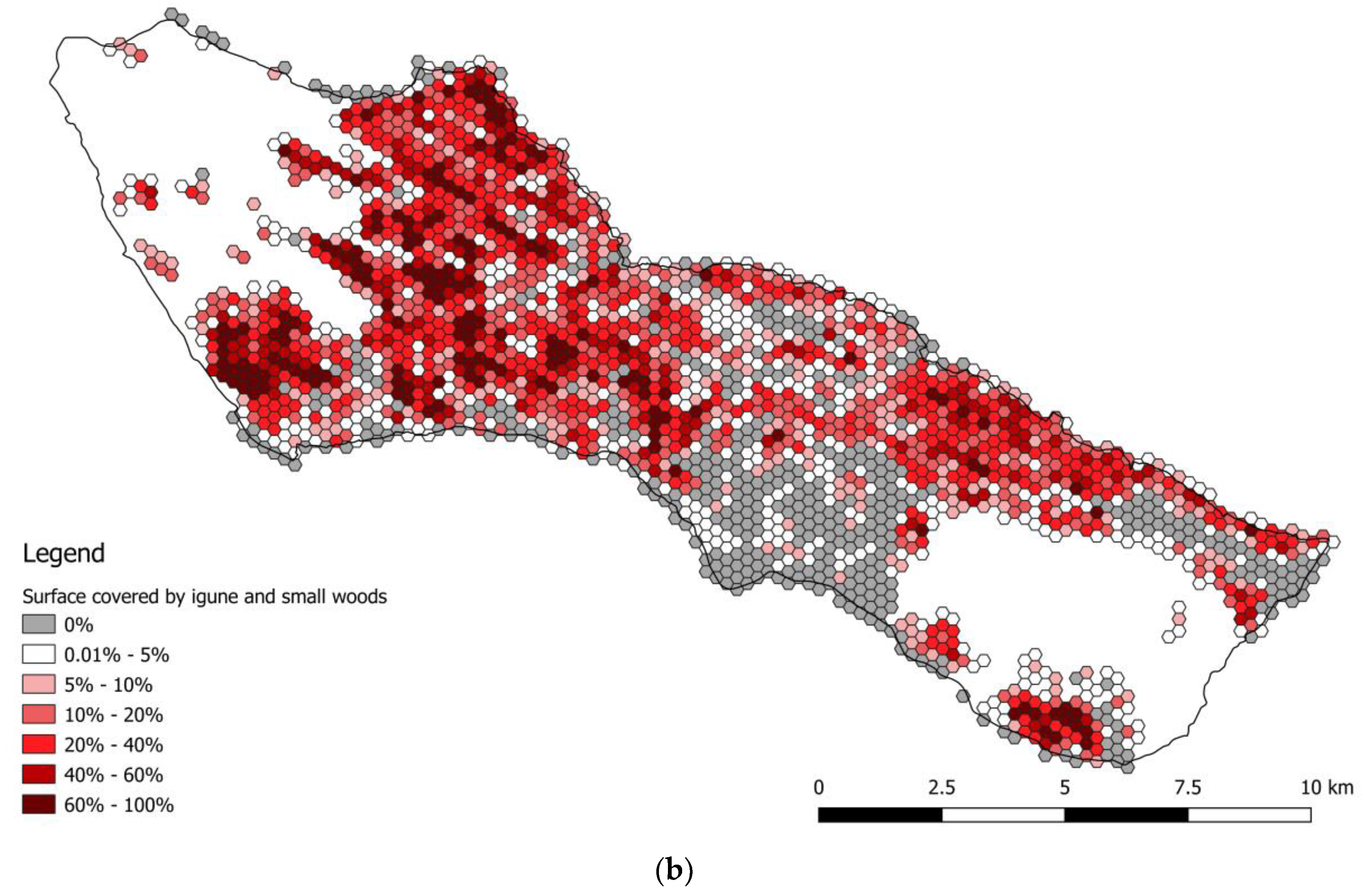
The analysis of the density of igune and other small woods based on the hexagon grid (Table 4) shows that most of the hexagons (81% for both 2002 and 2021) include totally or partially one or more of these features, ranging from 1 feature (in 680 hexagons on a total of 2208 for 2002 and in 662 hexagons on a total of 2194 for 2021) up to 9 features (in 2 hexagons for both 2002 and 2021), with an average value equal to 1.8 patches/hexagon for both 2002 and 2021. Regarding the percentage of surface occupied by igune and other small woods per each hexagon, most of the hexagons fall into the range 0.1–10%, but some of them also reach the class 90–100%. As the situation is almost identical for 2002 and 2021 (Table 4) it was decided to include only the maps of 2021 (Figure 6), which allow us to make some further considerations. The map of the count of igune and other small woods per hexagon (Figure 6a) highlights that the hexagons containing a higher number of these features (from 5 to 9) are located in some specific portions of the study area, while at the same time, the map of the surface occupied by igune and other small woods per hexagon (Figure 6b) shows that higher percentages are located near the big forest node in the north-western part of the study area. This is due to the fact that this big forest node tends to split in wider but separated patches of forests, while the portion of the study area near the south-eastern forest node is mainly characterized by smaller but very dense igune and other small woods patches.

3.5. Literature Analysis

The literature analysis highlighted that few studies specifically focused on igune and other small woods exactly in the same study area, but the ones that we found demonstrated to be particularly interesting for assessing the different ESs provided by these small forest formations beyond the landscape role. Another important data point is that all the studies and reports that have been found focused only on one specific role (flora species, avian diversity, traditional knowledge loss, etc.), without evaluating their multifunctionality and ES provision as a whole. The GIAHS proposal document, instead, proved to be a key source of information.
Firstly, it is important to highlight that the surveyed landscape can be classified as a satoyama: a traditional Japanese cultural landscape combining a variety of features (forests, rice paddies, grasslands, ponds, and ditches) with strong functional interrelations among the different elements. The variety of landscape features often contributes to the creation of a landscape mosaic with a small-scale pattern and a complex structure. This complexity does not correspond to habitat fragmentation or isolation; on the contrary, it creates a variety of habitats, which is the major reason of high species diversity in Japanese satoyama [41,42,43]. In fact, according to Sasaki et al. [44], the loss of the small and characteristic landscape features (e.g., field margins, irrigation channels, ponds, small forest patches) in Japan agricultural landscape is found to have deteriorating effects on biodiversity. In the study area of Osaki Kōdo plain, igune and small woods played an important role in enabling farmers to survive under severe environmental conditions and, at the same time, they represent the most important characteristic of the local landscape, as approximately 40% of total local households continue to have an igune today [33]. During rice planting season, when rice paddies are filled with water, igune and other small woods become part of a unique landscape of small forests interspersed among the rice paddies. These small forests originated as a protection from the north winds for other crops that cannot survive submerged in water. In fact, the location of these woods is not accidental; they surround farmhouses and small cultivated fields mainly from the north-western side, while low shrubs are planted on the southern side of the farmhouses so direct sunlight can reach the houses and the small vegetable gardens. In addition, the economy of the area is still based on agriculture, in particular on rice production, considering that approximately 20% of the labor force population inside the GIAHS site is currently engaged in agricultural practices, and that 7,185 farm households rely on profits from the sales of agricultural product; in addition, 97% of farms has a surface under 10 hectares and family-run farms represent 94% of the total farms, highlighting the local importance of family and small-farming within the area.
The ecological network role is particularly important, and it is the main role taken into consideration in previous studies and reports carried out in the same area, especially as igune and other small forests are interspersed in an intensively cultivated landscape. Previous research, in fact, did not take into account the landscape role, but focused on the role of igune and small woods as important habitats, not only for vegetal species, but also for animals, including different species of birds [16,45], dragonflies, frogs [46], or small mammals, such as the raccoon dog [47]. Frogs, dragonflies, and spiders act as natural predators of the pests that infest rice plants, representing a biological pest control system and strengthening the functional relationship between igune and rice paddies [33]. Igune themselves can be considered as agrobiodiversity hotspot in relation to flora species, despite the small surface. Major tree species in local igune include Japanese cedar (Cryptomeria japonica), Neolitsea sericea, Cedrus deodara, Ginkgo biloba, hinoki cypresses (Chamaecyparis obtusa), Japanese black pine (Pinus thunbergii), Japanese persimmon (Diospyros kaki), Japanese zelkova (Zelkova serrata), Japanese chestnut (Castanea crenata), and Japanese alder (Alnus japonica). Other common plants are Japanese spindle (Euonymus japonicus), bamboos spp., Camellia spp., and Juniperus chinensis. Moreover, according to Imai et al. [16], species richness is generally higher in igune than in local secondary forests. The abundance of trees and other flora species is also confirmed by Osawa and Nanaumi [47], as during a tree census involving woodlots around 19 farmhouses within the same study area, they identified more than 70 tree species. Finally, according to the data included in the GIAHS nomination proposal, the overall number of flora species in homestead igune and other small woods for Osaki Kōdo is equal to 207 [33]. Thanks to this abundance of species, and to the accurate management based on traditional knowledge that favored the presence of different species and of a multilayered vertical structure, igune were, and still are, used as multipurpose woods, representing a complementary source of food and materials: lower branches and fallen leaves become fuel and compost, thick branches and tree thinning are used for wooden crafts and as fuel, fruit and nuts and plant shoots provide food. Trees such as camellia and Japanese nutmeg (Torreya nucifera) provide seeds for oil extraction, Amur cork tree (Phellodendron amurense) and plants such as Geranium thunbergii provide products for traditional medication, while higher trees can provide timber to be used as building material [48]. In addition, forest edges are considered one of the key features influencing biodiversity in agricultural landscapes of Japan, and the decrease in the typical satoyama mosaic can lead to the loss of ESs and farmland biodiversity, if farmland abandonment continues to follow the recent trends at the national level [44]. In the study area, igune and small woods are still widespread and related traditional activities, including collection of firewood and other byproducts, are still commonly practiced, and their cultural role remained significant, as small shrines are placed within them representing areas of faith for the local families [47].
Despite the literature analysis proving the importance of igune and small woods in relation to different topics (landscape, biodiversity, materials and byproducts, connectivity features, cultural role), their surface and importance is decreasing in many other Japanese satoyama. According to other research carried out in different study areas, in fact, some igune and small woods have been abandoned or cut down, as a consequence of the general decline in traditional rural lifestyle [48,49]. Another threat reported by Ishibai et al. [50] for a similar landscape in the Tonami Plain, where homestead woodlands are found around 60% of the farmhouses, is wind damage. Probably, the lack of traditional management caused a simplification of the vertical structure (from multilayered to single-layered), making these vegetation structures more susceptible to wind damages with the consequent loss of their original role (the defense from the cold winter winds).

4. Discussion

The study of landscape structure and arrangement is increasingly used for assessing and planning landscapes, for the quantification of landscape functions and/or of ESs [51,52,53], or to transfer the theories of landscape ecology to sustainable landscape planning and monitoring [54,55,56,57]. In addition, multitemporal analyses comparing the same landscape with the same methodology for different years allow us to measure changes over time and, therefore, to identify the integrity and vulnerability of a given landscape or of specific landscape features [58].
The results of the performed analyses confirm the importance of igune and other small woods for the local cultural landscape, as only marginal transformations regarding their overall surface, number, and spatial arrangement have been found for the last 20 years. The multitemporal analysis demonstrated that igune and other small woods continue to represent the main characteristic features of the local landscape, while without these features the study area would resemble any intensively cultivated plain with rice paddies. Moreover, the spatial pattern of the identified igune and other small woods results to be almost completely uniform and unchanged within the study area, as testified by the detailed mapping, and by the proximity and density analysis.
Igune and other small woods still represent the main distinctive feature of the surveyed landscape, resulting in it being heterogeneous and diversified, although the overall number of land uses is limited. In fact, the term landscape complexity does not refer only to the diversity and richness of landscape features, but also to the interspersion of patterns within the landscape, to their characteristics (particularly in terms of functioning), their size, shape, and connectivity [59,60,61]. The methodology applied in our research is also in line with what has been theorized by Ode et al. [62] regarding landscape complexity analysis, who suggested taking into account (1) distribution, (2) spatial organization, and (3) variation and shape of the surveyed features. Therefore, the surveyed cultural landscape can be effectively considered a heterogeneous and complex landscape, thanks to the uniform and widespread presence of igune and other small woods. In addition, landscape structures can be assessed and characterized through the use of hundreds of landscape metrics developed to measure landscape patterns across a multitude of applications [63]; however, according to different studies, there is no need to use too many landscape metrics to properly describe landscape heterogeneity and complexity [37,64]. In particular, the density of the surveyed feature, can be effectively used to describe landscape patterns irrespective of the scale [64], while the MPS provides reliable data about the grain of the different landscape features [65].
Most of the identified patches have a surface smaller than 0.5 hectares; most likely these patches can be considered real igune, while the ones with a surface bigger than 0.5 ha fall within the classification of forests according to the most used forest definition, the one of the FAO, stating that forests are land with a tree canopy cover of more than 10%, an area of more than 0.5 ha and a width of more than 20 m [66]. Igune, according to the FAO definition, can instead be assimilated to Trees Outside Forests (TOF), as they have an area between 0.05 and 0.5 ha, canopy cover ≥ 5% if trees are present (or ≥10% if combined trees, bushes, and shrubs), and width ≥ 3 m [67].
Beside the importance of igune and other small woods for the cultural landscape, results also highlighted their role as a feature of an ecological network connecting the two forest nodes. The Least-Cost Path analysis underlined that there is an ideal path connecting the two forest nodes that for 91% of the length passes through various igune and other small woods, with a maximum length outside these features equal only to 92 m. The proximity analysis verified that a substantial part (21.7%) of the surface of urban areas and paddy fields lies within 20 m from igune and other small woods, and another 46.1% is in the range 20–100 m; therefore, these features are really interspersed with the agricultural and urban areas and are almost evenly distributed in the local cultural landscape. The hexagon grid analysis confirmed that the spatial distribution of these small cultural forests is mainly uniform in the territory, except for the portion closer to Osaki city, as proved by the fact that 82.6% of the hexagons include (totally or partially) at least one patch of igune or other small woods.
The literature analysis of previous studies conducted in the same area, instead proved that igune and other small woods within the study area have a key role in providing multiple ESs to the local population (Table 5). At the same time the applied methodology combining literature and multitemporal analyses allowed us to identify the main threats affecting these small forests of cultural origin. The preservation of this cultural landscape depends on the regular management of igune and other small woods, applying traditional techniques, but is also related to the preservation of the characteristic spatial pattern and of the number of these features. It is crucial to maintain an equilibrium between rice paddies and igune and other small woods, as the increase in number and surface of small woods does not necessary correspond to the amelioration or preservation of their functional role. Secondary woods, developed as a consequence of forest clearings or after the abandonment of agriculture, could have a completely different species composition, vertical or horizontal structure, and functionalities from the original forests [68,69]. The fact that igune and other small woods still provide a wide range of ESs to the local community and stakeholders should encourage local public authorities not only to legally protect their number and extension, but, as all the local population and the environment benefit from their presence and functions, also to support local farmers with subsidies to favor the regular application of traditional management, especially because local farming structure is clearly based on family farming and smallholders. This is particularly important considering that no specific measures of conservation of igune are currently applied in the area and, therefore, their conservation is only based on the willingness of the local farmers who understand their importance and their related services.
Regarding the land use changes, the spread of solar panels in the last few years, followed by the expansion of agricultural and urban areas, represent the main threats. Agricultural intensification and/or urban sprawl are commonly considered the major threats to biodiversity, notably through their effects on landscape fragmentation [70] impacting the populations through two distinct effects, habitat loss and connectivity loss [20,23], but in the study area this risk is low, thanks to the integrity of the overall landscape structure, and igune and other small woods still clearly act as stepping stones preserving the connectivity and providing habitats for different species. On the other side, it is also necessary to report that the extent to which landscapes and habitats are connected or fragmented may also affect the rate and pattern of the spread of plant or human diseases, and invasion by nonnative species [24,71,72,73].
Table 5. List of Ecosystem Services provided by igune and other small woods within the study area. The Ecosystem Services classification is based on the Millennium Ecosystem Assessment [74].
Ecosystem Services1. Provisioning services1.1 Food and livelihood—including fruits and wild foods
1.2 Timber and fuelwoods
1.4 Ingredients for traditional medicine
2. Regulating services2.1 Climate regulation (local)
2.2 Plant disease and pest regulation—igune offer suitable habitat for rice pests’ natural predators.
2.3 Wind protection—the main traditional role of the igune allow secondary production protected by the north wind.
2.4 Ecological role—igune act as both biodiversity hotspot and stepping stones, connecting two forest nodes.
3. Cultural services3.1 Traditional landscape and aesthetic value
3.2 Traditional knowledge systems, cultural heritage and sense of place—shrines and cemetery often lays near igune.

5. Conclusions

Our research proved the importance of igune and other small wood for the local cultural landscape, as results of the spatial analyses demonstrated that no meaningful transformations occurred in the last 20 years. This result demonstrates that a cultural landscape can survive and can actively support the local population without major changes. The application of a multitemporal and other spatial analyses and the calculation of selected landscape metrics allowed us to characterize their spatial pattern, and to measure the landscape structure complexity and the transformations in the last 20 years. In addition, the accurate analysis of studies previously conducted within the same study area allowed the identification of the main ESs related to igune and other small woods. Summarizing the results of our research, it is possible to state that these small cultural forests effectively contribute to providing the following ESs to the local community:
  • Landscape: igune and other small woods still deeply characterize the local cultural landscape (satoyama), which otherwise would be merely an intensive agricultural landscape, like many others in plain areas.
  • Ecological network: igune and other small woods act as stepping stones connecting large forest patches.
  • Biodiversity hotspots: a particularly high number of trees and shrubs species can be found inside igune and other small woods, but igune also represent key habitats for spiders, frogs, and other rice pests’ natural predators that contribute to the agroecosystem balance.
  • Wind protection: the original role of igune is still important in the area to allow secondary production of vegetables near the farmhouses to integrate the local population diet.
  • Wood and non-wood forest products: igune and other small woods provide multiple products to local farmers, including timber, firewood, fruits, ingredients for traditional medicine, and food.
  • Cultural role: small shrines are often located within igune, demonstrating their strict connection with the local culture.
It is important to stress that these small forest formations are the clear result of cultural practices, and that their multifunctional role is closely connected to an active management by local farmers based on traditional knowledge. A hypothetical interruption of traditional management of igune could lead to a change in the vertical structure and in the species composition, with the consequent loss of one or more ESs. In fact, the tendency to evolve towards a single-layer structure could have negative consequences both on biodiversity, with the decrease in the number of vegetal species, and on the original role of protection against wind, as igune could result more subject to wind damages. Therefore, it is necessary to promote an active traditional management of igune and other small woods at a local level, highlighting their multifunctional role and the connections with the local cultural identity. The application of a mixed methodology, combining detailed multitemporal and spatial analyses with the analysis of the studies performed in the same area, effectively contributed to the assessment of the landscape structure and of the ESs, and can be replicated in similar cultural landscapes to reduce knowledge gaps, to identify the best conservation strategies, and to detect the main threats. Limitations of the research are related to the fact that, for deeply investigating the ecological network, it is necessary to consider also other land uses (i.e., urban areas, rice paddies, shrublands), possible obstacles related to the presence of roads and railways, and to refer to specific fauna species, as each of them is characterized by a different behavior. In addition, specific studies on the perception of igune by the local population could be useful to further investigate the cultural value of these small forests. These kinds of analyses, however, are out of the scope of this research, the focus of which was on deepening the knowledge of igune and on assessing the landscape structure and the ESs within a specific and well-known cultural landscape. Results of our research could be used to inform local stakeholders about the importance and the main threats related to igune and other small woods but could also represent a baseline for monitoring and measuring possible transformations in the near future.

Author Contributions

Conceptualization, A.S. and F.P.; methodology, A.S., F.P. and B.F.; software, F.P.; writing—original draft preparation, A.S., F.P. and B.F.; supervision, A.S. All authors have read and agreed to the published version of the manuscript.

Funding

This research received no external funding.

Institutional Review Board Statement

Not applicable.

Informed Consent Statement

Not applicable.

Data Availability Statement

Data available on request.

Conflicts of Interest

The authors declare no conflict of interest.

References

  1. Sauer, C. The Morphology of Landscape. University of California Publications in Geography. In Land and Life: A Selection from the Writings of Carl Ortwin Sauer; University of California Press: Oakland, CA, USA, 1925; Volume 2.2. [Google Scholar]
  2. Council of Europe. The European Landscape Convention; Council of Europe: Strasbourg, France, 2000.
  3. Ministerial Conference on the Protection of Forests in Europe (MCPFE). In State of Europe’s Forests 2003; MCPFE Liaison Unit: Vienna, Austria, 2003.
  4. Agnoletti, M.; Anderson, S.; Johann, E. Guidelines for the Implementation of Social and Cultural Values in Sustainable Forest Management: A Scientific Contribution to the Implementation of MCPFE–Vienna Resolution 3; IUFRO Occasional Paper 19; IUFRO: Vienna, Austria, 2007. [Google Scholar]
  5. UNESCO; CBD Secretariat (SCBD). UNESCO–CBD Joint Program between Biological and Cultural Diversity; UNESCO: Paris, France, 2010.
  6. Antrop, M. Why landscapes of the past are important for the future. Landsc. Urban Plan. 2005, 70, 21–34. [Google Scholar] [CrossRef]
  7. Wiggering, H.; Müller, K.; Werner, A.; Helming, K. The Concept of Multifunctionality in Sustainable Land Development. In Sustainable Development of Multifunctional Landscapes; Springer: Berlin, Germany, 2003; pp. 3–18. [Google Scholar]
  8. Qiu, Z.; Chen, B.; Takemoto, K. Conservation of terraced paddy fields engaged with multiple stakeholders: The case of the Noto GIAHS site in Japan. Paddy Water Environ. 2014, 12, 275–283. [Google Scholar] [CrossRef]
  9. Matsuno, Y.; Nakamura, K.; Masumoto, T.; Matsui, H.; Kato, T.; Sato, Y. Prospects for multifunctionality of paddy rice cultivation in Japan and other countries in monsoon Asia. Paddy Water Environ. 2006, 4, 189–197. [Google Scholar] [CrossRef]
  10. Koohafkan, P.; Altieri, M.A. Globally Important Agricultural Heritage Systems: A Legacy for the Future; Food and Agriculture Organization of the United Nations: Rome, Italy, 2011. [Google Scholar]
  11. Ramakrishnan, P.S. Globally Important Ingenious Agricultural Heritage Systems (GIAHS): An Eco-Cultural Landscape Perspective; GIAHS Background Document; Food and Agriculture Organization of the United Nations: Rome, Italy, 2004. [Google Scholar]
  12. Santoro, A.; Venturi, M.; Bertani, R.; Agnoletti, M. A review of the role of forests and agroforestry systems in the FAO Globally Important Agricultural Heritage Systems (GIAHS) programme. Forests 2020, 11, 860. [Google Scholar] [CrossRef]
  13. Ritchie, H.; Roser, M.; Urbanization. Our World Data. 2018. Available online: https://ourworldindata.org/urbanization (accessed on 5 July 2022).
  14. Holt-Giménez, E. Can We Feed the World without Destroying It? John Wiley & Sons: Hoboken, NJ, USA, 2019. [Google Scholar]
  15. Song, H.; Chen, P.; Zhang, Y.; Chen, Y. Study Progress of Important Agricultural Heritage Systems (IAHS): A Literature Analysis. Sustainability 2021, 13, 10859. [Google Scholar] [CrossRef]
  16. Imai, H.; Nakashizuka, T.; Oguro, M. Environmental factors affecting the composition and diversity of the avian community in igune, a traditional agricultural landscape in northern Japan. J. Ecol. Environ. 2017, 41, 8. [Google Scholar] [CrossRef]
  17. Hidalgo, P.J.; Hernández, H.; Sánchez-Almendro, A.J.; López-Tirado, J.; Vessella, F.; Porras, R. Fragmentation and Connectivity of Island Forests in Agricultural Mediterranean Environments: A Comparative Study between the Guadalquivir Valley (Spain) and the Apulia Region (Italy). Forests 2021, 12, 1201. [Google Scholar] [CrossRef]
  18. Noss, R.F. Landscape Connectivity: Different Functions at Different Scales. In Landscape Linkages and Biodiversity; Island Press: Washington, DC, USA, 1991; pp. 27–39. [Google Scholar]
  19. With, K.A.; Gardner, R.H.; Turner, M.G. Landscape connectivity and population distributions in heterogeneous environments. Oikos 1997, 78, 151–169. [Google Scholar] [CrossRef]
  20. Taylor, P.D.; Fahrig, L.; Henein, K.; Merriam, G. Connectivity is a vital element of landscape structure. Oikos 1993, 68, 571–573. [Google Scholar] [CrossRef]
  21. Siqueira, F.F.; De Carvalho, D.; Rhodes, J.; Archibald, C.L.; Rezende, V.L.; Van den Berg, E. Small Landscape Elements Double Connectivity in Highly Fragmented Areas of the Brazilian Atlantic Forest. Front. Ecol. Evol. 2021, 9, 304. [Google Scholar] [CrossRef]
  22. Tiang, D.C.F.; Morris, A.; Bell, M.; Gibbins, C.N.; Azhar, B.; Lechner, A.M. Ecological connectivity in fragmented agricultural landscapes and the importance of scattered trees and small patches. Ecol. Process. 2021, 10, 20. [Google Scholar] [CrossRef]
  23. Fischer, J.; Lindenmayer, D.B. Landscape modification and habitat fragmentation: A synthesis. Glob. Ecol. Biogeogr. 2007, 16, 265–280. [Google Scholar] [CrossRef]
  24. Rudnick, D.; Ryan, S.J.; Beier, P.; Cushman, S.A.; Dieffenbach, F.; Epps, C.W.; Gerber, L.; Hartter, J.; Jenness, J.; Kintsch, J.; et al. The role of landscape connectivity in planning and implementing conservation and restoration priorities. Issues Ecol. 2012, 16, 1–20. [Google Scholar]
  25. Tischendorf, L.; Fahrig, L. On the usage and measurement of landscape connectivity. Oikos 2000, 90, 7–19. [Google Scholar] [CrossRef]
  26. Agnoletti, M.; Santoro, A. Cultural values and sustainable forest management: The case of Europe. J. For. Res. 2015, 20, 438–444. [Google Scholar] [CrossRef]
  27. Agnoletti, M.; Piras, F.; Venturi, M.; Santoro, A. Cultural values and forest dynamics: The Italian forests in the last 150 years. For. Ecol. Manag. 2022, 503, 119655. [Google Scholar] [CrossRef]
  28. Parrotta, J.A.; Agnoletti, M. Traditional Forest-Related Knowledge and Climate Change. In Traditional Forest-Related Knowledge; Springer: Dordrecht, The Netherland, 2012; pp. 491–533. [Google Scholar]
  29. Parrotta, J.A.; Fui, H.L.; Jinlong, L.; Ramakrishnan, P.S.; Youn, Y.C. Traditional forest-related knowledge and sustainable forest management in Asia. For. Ecol. Manag. 2009, 257, 1987–1988. [Google Scholar] [CrossRef]
  30. Marentes, M.A.H.; Venturi, M.; Scaramuzzi, S.; Focacci, M.; Santoro, A. Traditional forest-related knowledge and agrobiodiversity preservation. The case of the chagras in the Indigenous Reserve of Monochoa (Colombia). Biodivers. Conserv. 2021, 1–16. [Google Scholar] [CrossRef]
  31. Kottek, M.; Grieser, J.; Beck, C.; Rudolf, B.; Rubel, F. World Map of the Köppen-Geiger climate classification updated. Meteorol. Z. 2006, 15, 259–263. [Google Scholar] [CrossRef]
  32. Japanese Census Data. Available online: https://www.citypopulation.de/en/japan/miyagi/ (accessed on 5 July 2022).
  33. Osaki Region Committee for the Promotion of Globally Important Agricultural Heritage Systems. Osaki Kōdo’s Traditional Water Management System for Sustainable Paddy Agriculture; Food and Agriculture Organization: Rome, Italy, 2017; Available online: http://www.fao.org/3/CA3168EN/ca3168en.pdf (accessed on 5 September 2022).
  34. McCarigal, K.; Cushman, S.A.; Neel, M.C.; Ene, E. FRAGSTATS: Spatial Pattern Analysis Program for Categorical Maps, version 3.0; University of Massachusetts: Amherst, MA, USA, 2002. [Google Scholar]
  35. McCarigal, K.; Marks, B.J. FRAGSTATS: Spatial Pattern Analysis Program for Quantifying Landscape Structure; General Technical Report PNW-GTR-351; US Department of Agriculture, Forest Service: Washington, DC, USA, 1995.
  36. Adamczyk, J.; Tiede, D. ZonalMetrics—A Python toolbox for zonal landscape structure analysis. Comput. Geosci. 2017, 99, 91–99. [Google Scholar] [CrossRef]
  37. Venturi, M.; Piras, F.; Corrieri, F.; Fiore, B.; Santoro, A.; Agnoletti, M. Assessment of Tuscany Landscape Structure According to the Regional Landscape Plan Partition. Sustainability 2021, 13, 5424. [Google Scholar] [CrossRef]
  38. Pullin, A.S.; Stewart, G.B. Guidelines for systematic review in conservation and environmental management. Conserv. Biol. 2006, 20, 1647–1656. [Google Scholar] [CrossRef]
  39. Gates, S. Review of methodology of quantitative reviews using meta-analysis in ecology. J. Anim. Ecol. 2002, 71, 547–557. [Google Scholar] [CrossRef]
  40. Fazey, I.; Salisbury, J.G.; Lindenmayer, D.B.; Maindonald, J.; Douglas, R. Can methods applied in medicine be used to summarize and disseminate conservation research? Environ. Conserv. 2004, 31, 190–198. [Google Scholar] [CrossRef]
  41. Washitani, I. Traditional sustainable ecosystem ‘SATOYAMA’ and biodiversity crisis in Japan: Conservation ecological perspective. Global Environ. Res. 2001, 5, 119–133. [Google Scholar]
  42. Katoh, K.; Sakai, S.; Takahashi, T. Factors maintaining species diversity in satoyama, a traditional agricultural landscape of Japan. Biol. Conserv. 2009, 142, 1930–1936. [Google Scholar] [CrossRef]
  43. Kobori, H.; Primack, R.B. Participatory conservation approaches for satoyama, the traditional forest and agricultural landscape of Japan. AMBIO A J. Hum. Environ. 2003, 32, 307–311. [Google Scholar] [CrossRef]
  44. Sasaki, K.; Hotes, S.; Ichinose, T.; Doko, T.; Wolters, V. Hotspots of Agricultural Ecosystem Services and Farmland Biodiversity Overlap with Areas at Risk of Land Abandonment in Japan. Land 2021, 10, 1031. [Google Scholar] [CrossRef]
  45. Endo, K.; Hirano, T. Breeding records and nesting habitats of the Japanese lesser sparrowhawk Accipiter gularis in residential area of Tochigi prefecture Honshu Japan. Jpn. J. Ornithol. 1990, 39, 35–39. [Google Scholar] [CrossRef]
  46. Osawa, S.; Katsuno, T. The distribution of frogs on paddies locating different landforms in alluvial fan area. J. Rural. Plan. Assoc. 2001, 19, 280–288. [Google Scholar] [CrossRef]
  47. Osawa, S.; Nanaumi, E. The characteristics of the premises forests, known as Igune, and the damage caused by recent tsunamis to the forests around the Okuma district, Watari town, in the central region of the Sendai plains. J. Jpn. Inst. Landsc. Archit. 2015, 78, 755–760. [Google Scholar] [CrossRef]
  48. Hirabuki, Y.; Fukuda, A. Farmstead groves and traditional Lifestyle. 1. Development process of two environmental educational programs based on local area field trail results. Proc. Miyagi Univ. Educ. 2006, 9, 59–66. [Google Scholar]
  49. Koganezawa, T.; Kitagawa, N.; Kato, Y. Environmental education and Igune school. Proc. Miyagi Univ. Educ. 2002, 4, 29–36. [Google Scholar]
  50. Ishibai, N.; Fukamachi, K.; Oku, H.; Shibata, S. Residents’ perception and measures for conservation of homestead woodlands in the Tonami Plain, Japan. J. Jpn. Inst. Landsc. Arch. 2018, 81, 549–552. [Google Scholar] [CrossRef] [Green Version]
  51. Syrbe, R.U.; Walz, U. Spatial indicators for the assessment of ecosystem services: Providing, benefiting and connecting areas and landscape metrics. Ecol. Indic. 2012, 21, 80–88. [Google Scholar] [CrossRef]
  52. Syrbe, R.U.; Bastian, O.; Röder, M.; James, P. A framework for monitoring landscape functions: The Saxon Academy Landscape Monitoring Approach (SALMA), exemplified by soil investigations in the Kleine Spree floodplain (Saxony, Germany). Landscape 2007, 79, 190–199. [Google Scholar] [CrossRef]
  53. Lausch, A.; Blaschke, T.; Haase, D.; Herzog, F.; Syrbe, R.U.; Tischendorf, L.; Walz, U. Understanding and quantifying landscape structure–A review on relevant process characteristics, data models and landscape metrics. Ecol. Model. 2015, 295, 31–41. [Google Scholar] [CrossRef]
  54. Leitão, A.B.; Ahern, J. Applying landscape ecological concepts and metrics in sustainable landscape planning. Landsc. Urban Plan. 2002, 59, 65–93. [Google Scholar] [CrossRef]
  55. Herzog, F.; Lausch, A. Supplementing land-use statistics with landscape metrics: Some methodological considerations. Environ. Monit. Assess. 2001, 72, 37–50. [Google Scholar] [CrossRef]
  56. Almenar, J.B.; Bolowich, A.; Elliot, T.; Geneletti, D.; Sonnemann, G.; Rugani, B. Assessing habitat loss, fragmentation and ecological connectivity in Luxembourg to support spatial planning. Landsc. Urban Plan. 2019, 189, 335–351. [Google Scholar] [CrossRef]
  57. Viana, C.M.; Rocha, J. Evaluating Dominant Land Use/Land Cover Changes and Predicting Future Scenario in a Rural Region Using a Memoryless Stochastic Method. Sustainability 2020, 12, 4332. [Google Scholar] [CrossRef]
  58. Agnoletti, M.; Emanueli, F.; Corrieri, F.; Venturi, M.; Santoro, A. Monitoring Traditional Rural Landscapes. The Case of Italy. Sustainability 2019, 11, 6107. [Google Scholar] [CrossRef]
  59. Ode, Å.; Miller, D. Analysing the relationship between indicators of landscape complexity and preference. Environ. Plan. B Plan. Des. 2011, 38, 24–40. [Google Scholar] [CrossRef]
  60. GCTE. Focus 4: Global Change and Ecological Complexity, Draft 5, dated 22 March 1996. In Ecological Studies; Springer: New York, NY, USA, 1996. [Google Scholar]
  61. Papadimitriou, F. Modelling indicators and indices of landscape complexity: An approach using GIS. Ecol. Indic. 2002, 2, 17–25. [Google Scholar] [CrossRef]
  62. Ode, Å.; Hagerhall, C.; Sang, N. Analysing visual landscape complexity: Theory and application. Landsc. Res. 2010, 35, 111–131. [Google Scholar] [CrossRef]
  63. Frazier, A.E.; Kedron, P. Landscape metrics: Past progress and future directions. Curr. Landsc. Ecol. Rep. 2017, 2, 63–72. [Google Scholar] [CrossRef]
  64. Plexida, S.G.; Sfougaris, A.I.; Ispikoudis, I.P.; Papanastasis, V.P. Selecting landscape metrics as indicators of spatial heterogeneity—A comparison among Greek landscapes. Int. J. Appl. Earth Obs. Geoinf. 2014, 26, 26–35. [Google Scholar] [CrossRef]
  65. Herzog, F.; Lausch, A. Prospects and limitations of the application of landscape metrics for landscape monitoring. In Heterogeneity in Landscape Ecology: Pattern and Scale, Proceedings of the 8th Annual Conference of the International Association of Landscape Ecology, Bristol, UK, 6–8 September 1999; Maudsley, M., Marshall, J., Eds.; IALE: Scotland, UK, 1999; pp. 41–50. [Google Scholar]
  66. Food and Agriculture Organization (FAO). Global Forest Resources Assessment 2000; Main Report; FAO: Rome, Italy, 2000. [Google Scholar]
  67. de Foresta, H.; Somarriba, E.; Temu, A.; Boulanger, D.; Feuilly, H.; Gauthier, M.; Taylor, D. Towards the Assessment of Trees Outside Forests: A Thematic Report Prepared in the Framework of the Global Forest Resources Assessment 2010; FAO: Rome, Italy, 2013. [Google Scholar]
  68. Guariguata, M.R.; Ostertag, R. Neotropical secondary forest succession: Changes in structural and functional characteristics. For. Ecol. Manag. 2001, 148, 185–206. [Google Scholar] [CrossRef]
  69. Corlett, R.T. What is secondary forest? J. Trop. Ecol. 1994, 10, 445–447. [Google Scholar] [CrossRef]
  70. Stoate, C.; Boatman, N.; Borralho, R.; Carvalhob, C.R.; de Snoo, G.R.; Eden, P. Ecological impacts of arable intensification in Europe. J. Environ. Manag. 2001, 63, 337–365. [Google Scholar] [CrossRef]
  71. VanAcker, M.C.; Little, E.A.; Molaei, G.; Bajwa, W.I.; Diuk-Wasser, M.A. Enhancement of risk for lyme disease by landscape connectivity, New York, New York, USA. Emerg. Infect. Dis. 2019, 25, 1136. [Google Scholar] [CrossRef] [PubMed]
  72. Minor, E.S.; Tessel, S.M.; Engelhardt, K.A.; Lookingbill, T.R. The role of landscape connectivity in assembling exotic plant communities: A network analysis. Ecology 2009, 90, 1802–1809. [Google Scholar] [CrossRef] [PubMed]
  73. Wang, Z.; Wu, J.; Shang, H.; Cheng, J. Landscape connectivity shapes the spread pattern of the rice water weevil: A case study from Zhejiang, China. Environ. Manag. 2011, 47, 254–262. [Google Scholar] [CrossRef] [PubMed]
  74. Board, M.A. Millennium Ecosystem Assessment; New Island: Washington, DC, USA, 2005. [Google Scholar]
Figure 1. The study area (red border) corresponds to the main part of the GIAHS site called Osaki Kodo’s Traditional Water Management System for Sustainable Paddy Agriculture, and is located across the territories of Osaki, Kurihara, and Wakuya cities (light blue borders), in Miyagi Prefecture, Japan. It is possible to clearly observe the two big forest nodes in the north-west and south-east part of the study area.
Land 11 01494 g001
Figure 2. A high number of igune and other small woods are found around farmhouses or interspersed with paddy fields between the two forest nodes located in the north-west and south-east part of the study area.
Land 11 01494 g002
Figure 3. For both 2002 and 2021, most of the identified igune and small woods have a surface smaller than 1 ha.
Land 11 01494 g003
Figure 4. Number, size, and spatial pattern of igune and other small woods remained almost unchanged from 2002 to 2021.
Land 11 01494 g004
Figure 5. Map of the proximity of agricultural and urban areas from igune and other small woods for 2021. Results for 2002 are the same.
Land 11 01494 g005
Figure 6. Maps of the number of patches of igune and other small woods per hexagon (a), and of the surface occupied by igune and other small woods per hexagon (b) for 2021. The situation for 2002 is almost identical.
Land 11 01494 g006aLand 11 01494 g006b
Table 1. Landscape metrics calculated for igune and other small woods.
NameSymbolFormulaDescriptionReference
Number of patchesNP Total number of patches.
Mean Patch SizeMPSMPS = ai/ni
ai = area of the i land use class in hectares; ni = number of the i land use patches.
Average area of a patch of a particular class.[34]
Patch DensityPDPD = Ni/A * 100
Ni = total number of patches of the i class; A = total surface of the study area in hectares.
Number of patches of a
particular class calculated on the total surface of the study area excluding the forest nodes (standardized per 100 ha).
[35]
Landscape Shape IndexLSILSI = pi/(2 * √(π*ai))
pi = perimeter of the patch i in meters; ai = area of the patch i in hectares.
Derived from the Edge Density, it evaluates the degree of fragmentation through segmentation of edge. LSI increases without limit as the patch becomes more disaggregated.[35]
Table 2. Dimensional parameters (in hectares) and total number (NP) of igune and other small woods in 2002 and 2021.
YearTotal surfaceNPMPSQ1Q2Q3
20022115.617031.240.090.210.64
20212075.517371.190.090.200.60
Table 3. Spatial metrics calculated for the Least-Cost Path analysis for 2002 and 2021.
YearTotal Length (m)Length Inside Igune and Small Woods (%)Length Outside Igune and Small Woods (%)Number of Igune and Small Woods Crossed by LCPMaximum Length of LCP Segments Falling Outside Igune and Small Woods (m)Average Length of LCP Segments Falling Outside Igune and Small Woods (m)
200223,64791.1%8.9%739228
202121,91890.3%9.7%758828
Table 4. Number of patches of igune and other small woods per hexagon and surface (in percentage on the total hexagon surface) occupied by igune and other small woods per hexagon for 2002 and 2021. It is possible to notice that the situation is almost unchanged.
Igune and Other Small Woods Patch Count Per HexagonNumber of Hexagons
2002
Number of Hexagons
2021
Igune and Other Small Woods Surface Per HexagonNumber of Hexagons 2002Number of Hexagons 2021
04304230%433427
16806620.1–10%646652
248248910–20%332335
328928320–30%249247
418418630–40%180174
5879540–50%116107
6383650–60%8287
7101260–70%7877
86670–80%4138
92280–90%2626
100090–100%2524
Total22082194Total22082194
Publisher’s Note: MDPI stays neutral with regard to jurisdictional claims in published maps and institutional affiliations.