Article

Soil Organic Carbon Storage in Urban Green Space and Its Influencing Factors: A Case Study of the 0–20 cm Soil Layer in Guangzhou City

1
School of Public Administration, South China Agricultural University, Guangzhou 510642, China
2
Key Laboratory of Vegetation Restoration and Management of Degraded Ecosystems, South China Botanical Garden, Chinese Academy of Sciences, Guangzhou 510650, China
3
College of Forestry and Landscape Architecture, South China Agricultural University, Guangzhou 510642, China
4
Hunan Planning Institute of Land and Resources, Changsha 410007, China
*
Author to whom correspondence should be addressed.
Land 2022, 11(9), 1484; https://doi.org/10.3390/land11091484
Submission received: 8 August 2022 / Revised: 27 August 2022 / Accepted: 29 August 2022 / Published: 4 September 2022

Abstract

:
Urban soils can contribute to organic carbon sequestration. The socioeconomic drivers of soil organic carbon (SOC) in urban areas may differ between regions due to the different land tenure and its derived green space management regimes. Currently, few studies focus on regions where public ownership of land was implemented. We examined the SOC storage and driving factors of urban green spaces in Guangzhou, China at 0–20 cm depth by variance and regression analysis. Our results showed that the total SOC storage did not vary significantly among green space types, with an average value of 2.59 ± 1.31 kg/m2. SOC increased with plot age (2–87 years) by 0.025 kg/m2/year (p = 0.026) and plot size (63–2058 m2) by 0.001 kg/m2/m2 (p = 0.026). Disturbance intensity was negatively correlated to SOC storage. Green space maintenance practices could promote SOC sequestration, but this benefit may be offset by high-intensity disturbances such as trampling, litter and debris removal and fragmentation of green spaces. To increase urban residential SOC storage, except for remediation of compacted soils, it is essential to promote house owners’ initiative in green space management and conservation by improving the current residential green space management regimes.

1. Introduction

Although urban areas cover less than 0.5% of the global land surface [1], cities contribute more than 70% of global energy-related CO2 emissions [2]. Globally, urban land is projected to expand by more than 5.87 million km2 between 2000 and 2030 [3]. The population of urban residents will increase to 68% by 2050 [4], which highlights the importance of urban carbon management in mitigating global climate change [5]. Cities are often regarded as having high carbon emissions. However, recent research demonstrates that urban trees have the potential to store a substantial amount of plant carbon [6,7,8], and a widespread, increasing positive indirect effect of urbanization on vegetation growth has been found at the global scale [6]. The green spaces have higher carbon storage than adjacent rural forestlands, grasslands and agricultural land [9,10,11,12]. Considering the continuous urbanization, understanding and regulating ecosystem service of carbon sequestration provided by urban land is essential in helping to improve urban carbon management and mitigate global climate change [13].
Urbanization is related to soil degradation and soil sealing, which deplete soil organic carbon (SOC) pools [12,14,15]. However, the soil is still one of the largest organic carbon pools in the urban ecosystem [16]. Previous studies reported that residential soil had a considerable potential to accumulate carbon [10,17,18,19,20]. For instance, Contosta et al. reported that the 0–50 cm SOC storage in the urban residential yards of Manchester, USA, was almost eight times larger than that of tree carbon [21]. Raciti et al. found that cultivated or forested soils in residential sites before development in Baltimore, USA, had higher carbon densities than present-day forested soils of similar types due to the rapid carbon accumulation [18]. Given the considerable carbon sequestration capacity, soil carbon management in urban areas needs to be considered an important strategy to advance sustainable urban carbon management [13]. However, compared with natural and agricultural ecosystems, fewer studies focus on SOC sequestration in urban ecosystems [22], especially the global patterns of urban soil carbon and its share of the global soil carbon budget [13,23]. The importance of enhancing SOC storage in urban soils is still primarily neglected by urban policymakers [24].
Soil properties in urban areas are highly heterogeneous [25,26], and SOC density varies greatly by land-use type [12,22,27,28]. For example, some researchers reported high SOC storage in urban residential areas [11,13,21,25,27,29]. In contrast, Sun et al. found that the SOC storage in the 0–100 cm soil of residential districts was much lower than that of traffic and industrial districts in Kaifeng, China [30], while Liu et al. reported that SOC stock in the 0–10 cm layer of parkland in Chongqing, China was higher than that of other green lands [31]. Canedoli et al. found high SOC stock in urban parks of Milan in Italy [22]. These inter- and intra-city variabilities of SOC storage highlight the necessity of more soil surveys for each land use/cover type in cities to reduce the uncertainty in carbon pool estimation in urban ecosystems [22,32].
Understanding the drivers of SOC stocks in an urban area is crucial for policymaking to enhance urban carbon stock [21]. Prior studies have examined how human-mediated biogeochemical drivers (e.g., climate, soil type, land use, plant type or management regime) or socioeconomic factors (e.g., population density, housing age, lifestyle behavior, household income, home ownership) affect urban soil stocks [10,13,18,21,23,26,29,33,34,35]. Urban SOC biogeochemical cycles are controlled by complex interactions between anthropogenic and natural drivers [13,26]. Human population dynamics exert significant controls on biogeochemical cycles due to engineering structure, energy and food demand [36]. In China, high-density urban areas with low c coverage have been developed to balance the demands between living space and food production as a result of the large population, leading to the high fragmentation of urban green spaces [37], which, in turn, increases the possibility of human disturbance (e.g., stepping on the grass, limiting environmental conditions caused by the surrounding impervious surface) on plant and soil carbon sequestration. Household-scale drivers such as landscape design and lawn management regimes (e.g., fertilization, irrigation) are constrained by institutional and socioeconomic factors [36]. Under the state-controlled property regime in China, the real estate development company directly designs and constructs urban residential greening under national, provincial and municipal legislation. The maintenance and management of these residential green spaces are under the responsibility of the property management company. The urban parks and roadside green belts are under the administration of the bureau of landscaping, which authorizes landscape companies to manage and maintain these green spaces. Therefore, compared with private land ownership, individuals have little influence on the decisions of green space design and its management practices, making China an exceptional region for studying urban SOC dynamics and its anthropogenic drivers.
At the general debate of the 75th session of the United Nations General Assembly in 2020, China committed to constraining peak CO2 emissions by 2030 and achieving carbon neutrality by 2060. To achieve the goal of increasing carbon sequestration and reducing carbon emissions, new guiding philosophies ideology of urban land growth, such as “urban growth boundary” and “ecological red line”, have been incorporated into the land use planning regimes, and many greening projects have been implemented by central and local governments. For example, the Guangzhou government has implemented many ecological projects, such as greenway network construction, vest-pocket park construction and green space coverage in developed urban areas during the past two decades.
Datasets representing a wide range of climatic and urban-specific factors (city population, city area, management, etc.) are needed for the analysis of global patterns of urban soil carbon [13]. As China is the most populated country, its datasets are essential for the presentation of these global patterns. However, until now, SOC storage in urban soils in China has not been extensively documented. The carbon stock of Guangzhou, a megacity in China, and its influencing factors, still remain unclear. Here, we took Guangzhou city as a case study to investigate the SOC storage in different urban green spaces and related factors using a chronosequence of 72 green space plots. We aimed to explore SOC storage in four types of urban green spaces at 0–20 cm depth and examine how plot age, plot size, maintenance, human disturbance, soil type, soil texture and land use impact SOC stock. Information about the relationship of SOC storage to these factors would benefit urban landscape design and green space management to achieve sustainable development for China cities.

2. Materials and Methods
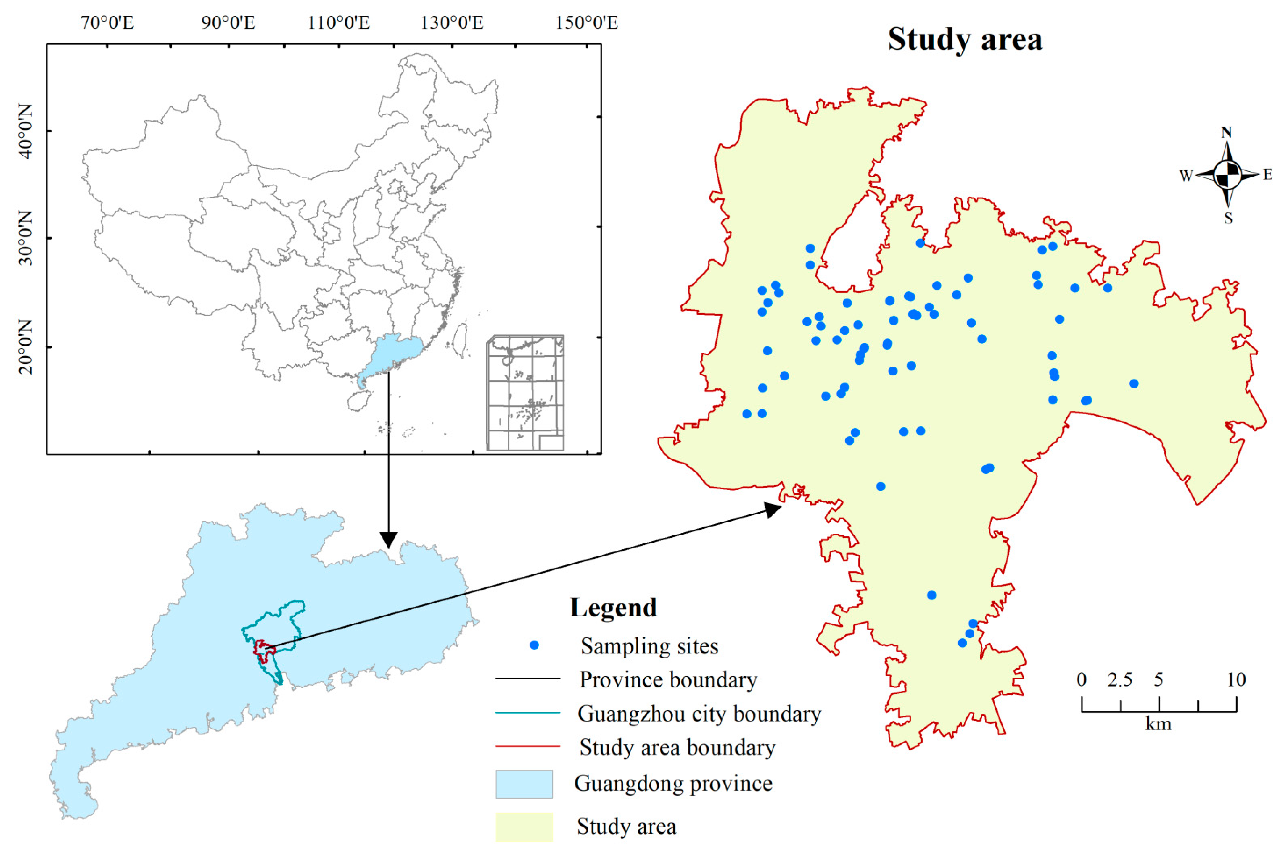
2.1. Study Site

The study site was located in Guangzhou (112°57′~114°03′ E, 22°26′~23°56′ N) in southern China. The climate is a humid, subtropical monsoon with a 10-year mean minimum and maximum temperature of 21.8 and 23.1 °C, respectively, and a mean minimum and maximum precipitation of 1421.2 and 2638.3 mm, respectively [38]. The dominant soils are classified as lateritic red soil and paddy soil [39]. The land area of Guangzhou is 7434.40 km2 and it had a population density of 2521 km−2 in 2021 [38]. As the economic and transportation center of South China, developed areas cover 18.16% of the city’s land area, and green spaces cover 45.52% of the developed area [38].

2.2. Experimental Design and Soil Sampling

Based on Google Earth images (0.27 m resolution), we selected seven of the total 11 districts of Guangzhou’s main area (735.66 km2, ArcGIS version 10.4, ESRI) (Figure 1). The study area is separated by rivers, woodlands, farmland and rural settlements from the surrounding regions. We designed soil sample plots according to the typical urban land use types in the urban core area, namely residential land, transportation-related land, public parks and mini parks beside streets, which correspond to the urban green space types of residential green space (thirty-two plots), roadside greenbelt (fifteen plots), public parks (seventeen plots) and pocket parks (six plots), respectively (Figure 1). Two plots in the university campus were also sampled and grouped into residential green space. The grid formed by road networks was used to establish sample plots, and all sampling plots except campuses were randomly selected. A grid covering the Yuexiu, Liwan, Haizhu, southern Tianhe and Huangpu districts was formed by taking the three east–west main roads (Fangcun–Huadi–Changgang–Xingang, Zhongshan–Huangpu–Dasadi–Xianlie and Guangyuan road) as horizontal axes and the roads intersecting with these three axes as vertical axes. A grid covering the southern Baiyun, the northern Tianhe and the southwest Huangpu district was formed by taking four north–south main roads as vertical axes and the roads intersecting with these four axes as horizontal axes. Plots in the Panyu district were located along Shixin, Qiaoxing, Leyuan and Donghuan roads. We sampled 1–2 plots in each grid based on plot size. When permission was not granted, the nearby green space was sampled. In addition, we also sampled four clean fill soils from newly greening construction plots. Photos of some of the urban green spaces and soil samples have been presented in Figure S1. Climate is a key factor in SOC storage at global and broad regional scale [23,40]. We ignored the climatic conditions because the subtropical monsoon climate covers all the sample plots in this study area (735.66 km2).
Soil samples were collected in July of 2019, and the plot size varied from 63 m2 to 2058 m2 due to the high fragmentation of urban green space. In each sample plot, three replicate samples were collected. For each soil sample, three randomized soil cores (4 cm diameter) were taken from the 0–20 cm depth to yield one composite sample. Soil samples were passed through a 2 mm sieve to remove rocks, roots, and other debris and then air-dried for further analysis. The content of SOC was determined for all ground bulk soil samples using the potassium dichromate–oil bath external heating method [41]. SOC stock (kg/cm2) in green space was calculated using Equation (1):
SOC   stock = C × θ × D × ( 1 δ ) / 100
where C represents the SOC content (g/kg); θ represents the bulk density, an averaged value of 1.38 g/cm3 from references (1.41 g/cm3 for the A-horizon of university campus soils sampled by Guan et al. [42], 1.38 g/cm3 for residential soils at 0–15 cm depth sampled by Zhuo et al. [43] and values for the 0–10 cm soil of urban green spaces from Zhu et al. [44]); D represents the depth of soil layer (20 cm); δ represents the volume ratio of gravel greater than 2 mm in diameter (an averaged value of 4.4% from references of Jim [45] and Zhang et al. [46]). To better compare with green spaces, the θ and δ in clean fill soil were assigned the same values estimated in green soils.

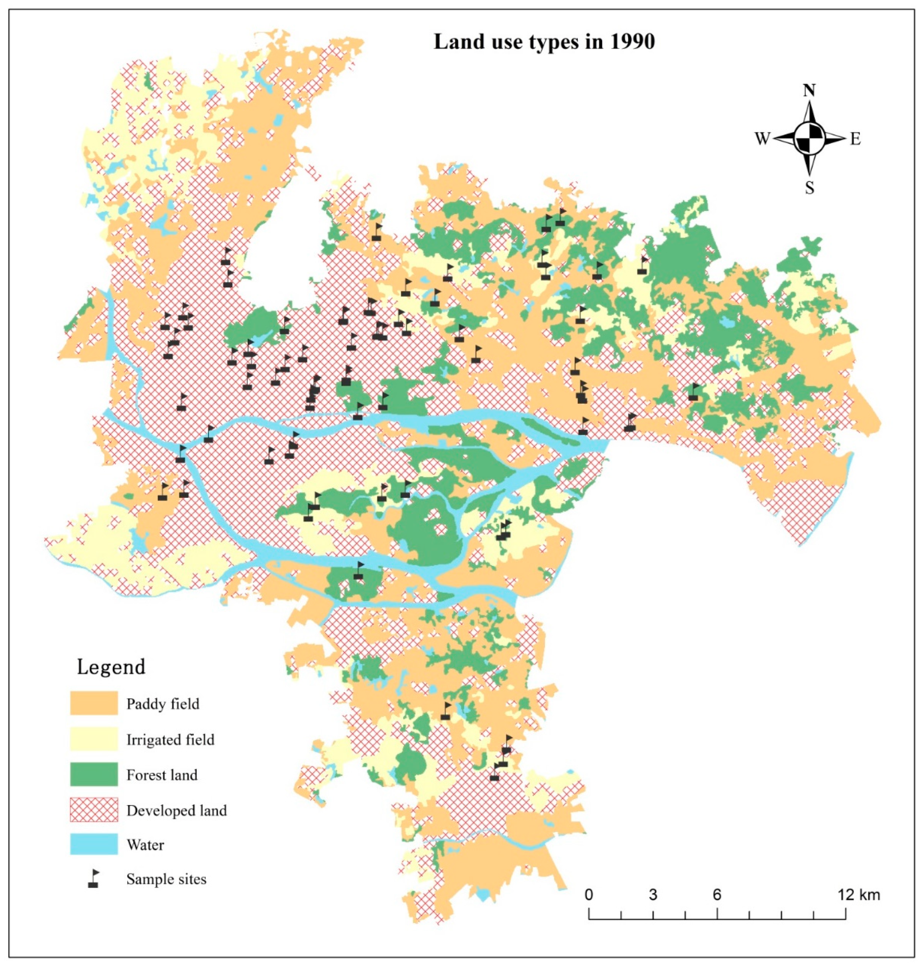
2.3. Data Sources of Soil Type, Soil Texture and Land Use History

The soil type of each sample site was determined according to the Guangzhou Soil Type Map in 1985 (1:200,000) provided by the Department of Agriculture and Rural Affairs of Guangdong Province. Soil clay and silt content of each soil type in farmland or natural ecosystems were obtained from the book Soil Chorography of Guangdong Province [47]. The book and soil type map belong to the second soil census dataset of Guangdong Province. For sample sites located in the historically developed land (not included in the second soil census), we took the average clay and silt content in urban soils of green spaces reported by Zhu et al. [44] as a reference. Rapid urbanization in Guangzhou began in the 1990s. We used the land use/cover map interpreted from Landsat images (30 m resolution) in 1990 [48] to characterize the land use history. By clipping this with the boundary of our study area (ArcGIS, version 10.4), we obtained the historical land use types and classified them into paddy fields (rice), irrigated fields, forest land, water and developed land. By matching the coordinates of the sample plots with the soil type map and land use/cover map, we obtained the soil type and land use type data of each sample plot.

2.4. Statistical Analysis

An ANOVA procedure was performed to determine if mean SOC storage differed with green space types, maintenance and disturbance types, and the statistical significance was determined as p < 0.05. All data were checked for normal distribution and homogeneous variances. When data were not normally distributed, logarithmic transformation was performed. Multiple comparisons and analyses of variance with the Tukey test were performed to test the difference in SOC content and stock between green space types and disturbance intensity types.
Simple linear regression analysis was performed to assess the relationship between the SOC storage and plot age or plot size. Plot age was represented as the period since road, park and residential community construction. Building age data were collected from real estate agents on a website (zfcj.gz.gov.cn/zfcj/ygjy, accessed on 15 January 2022); park age data were obtained on the official websites of the parks, and the road age data were obtained from the website (http://baike.baidu.com, accessed on 7 August 2022). The period of the whole sample plot was 2 to 101 years, and the home age spanned 10 to 29 years. Public parks spanned 5 to 101 years. We set up a series of paired younger and older home age classes to reveal the differences in SOC accumulation rates [33]. The youngest class was 2–10 years, which contained 11 plots, followed by 2–15 years, 2–20 years, 2–35 years (there were only four plots of 25–35 years and these were grouped with plots of 2–35 years) and 2–101 years (only seven plots had age span larger than 35 years and these were grouped with plots of 2–101 years). The elder age class started with 16–20 years, followed by 16–25 years, 16–35 years, 16–101 years, 21–25 years, 21–35 years and 21–101 years.
Multiple and stepwise regression analyses were performed to explore the key drivers of SOC storage among factors of plot age, plot size, maintenance practices, disturbance types, soil texture, soil type and land use history. Soil type and land use history were all treated as dummy variables. The reference category for the soil type variable was the soil in the developed land. The reference category for land use history variable was the historically developed land. The methodology flowchart is presented in Figure S2.
The statistical significance was determined as p < 0.1 for all regression models. All statistical analyses were performed using SPSS version 17.0 (International Business Machines Corporation, Chicago, IL, USA). The value assignment of maintenance practices and disturbance types was listed as follows.
The management intensity of watering, fertilization, mowing and pesticide use could not be investigated in detail on every sampled plot; we used a binary variable to specify the effect of maintenance practice. We used 1 for public parks, greenbelts beside roads and green space in universities because of their periodic maintenance by garden workers, and 0 for residential plots and pocket parks beside streets, which are usually under low maintenance.
According to visitor flow and human trampling on vegetation and soil, the disturbance intensity types were classified as high, medium and low groups. High-disturbance plots were assigned the values of 3, 2 and 1 for medium and low groups, respectively. Plots with evident marks of trampling (such as reduced plant cover, evident soil compaction and ongoing recreational activities) were grouped as a high-disturbance group (value of 3). Plots with little tramping were assigned a value of 1 and 2 for all remaining plots. Pocket parks were popular daily recreation places for children and the elderly, so they were all grouped into high-disturbance classes. Roadside greenbelts in the main urban area were grouped as low-disturbance plots because they are rarely visited due to their small size and safety concerns. One plot of roadside greenbelts was grouped as a medium class because of its small patches of degraded grassland (no high-intensity recreational stresses). Four residential green spaces with no obvious signs of trampling were grouped as the low-disturbance group. All public parks and other residential plots were grouped as medium-disturbance groups.

3. Results

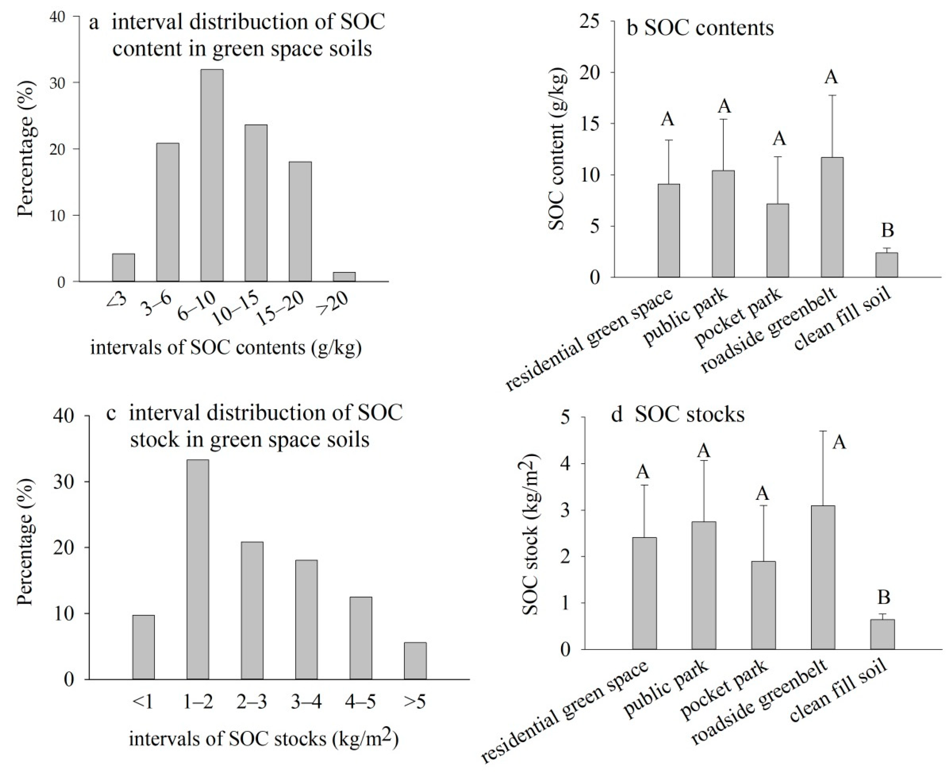
3.1. SOC Content and SOC Stocks

The SOC content of green spaces ranged from 7.17 ± 4.60 g/kg in pocket parks to 11.70 ± 6.09 g/kg in roadside greenbelts, with an average value of 9.80 ± 4.96 g/kg (Table 1). Among the four green spaces, more than 56% of sampled plots had less than 10 g/kg SOC content (Figure 2a). The clean fill soil had significantly lower SOC content than the four green spaces, and no significant difference was observed among the four green space types (Figure 2b).
The SOC stocks of green spaces show a similar trend in SOC content, with a lower value of 1.89 ± 1.21 kg/m2 in the pocket parks and a higher value of 3.09 ± 1.61 kg/m2 in the roadside greenbelts (Table 1). Among the four green spaces, more than 43% of plots had less than 2.0 kg/m2 SOC stock (Figure 2c). Similar to SOC content, the clean fill soil had significantly lower SOC stock than the four green spaces (Figure 2d).

3.2. Soil Type, Soil Texture and Land Use History

Eight soil types were involved in our sample plots, among which the type of developed land accounted for 44% and vegetable soil accounted for 26%. By soil type, the clay content ranged from 4.84% to 28.48%, and the silt content ranged from 16.65% to 43.42% (Table 2). According to the historical land use map interpreted from Landsat TM images (30 m resolution), 54% of the sample plots had already been developed in 1990 (39 samples) and farmland accounted for 28% (Figure 3).

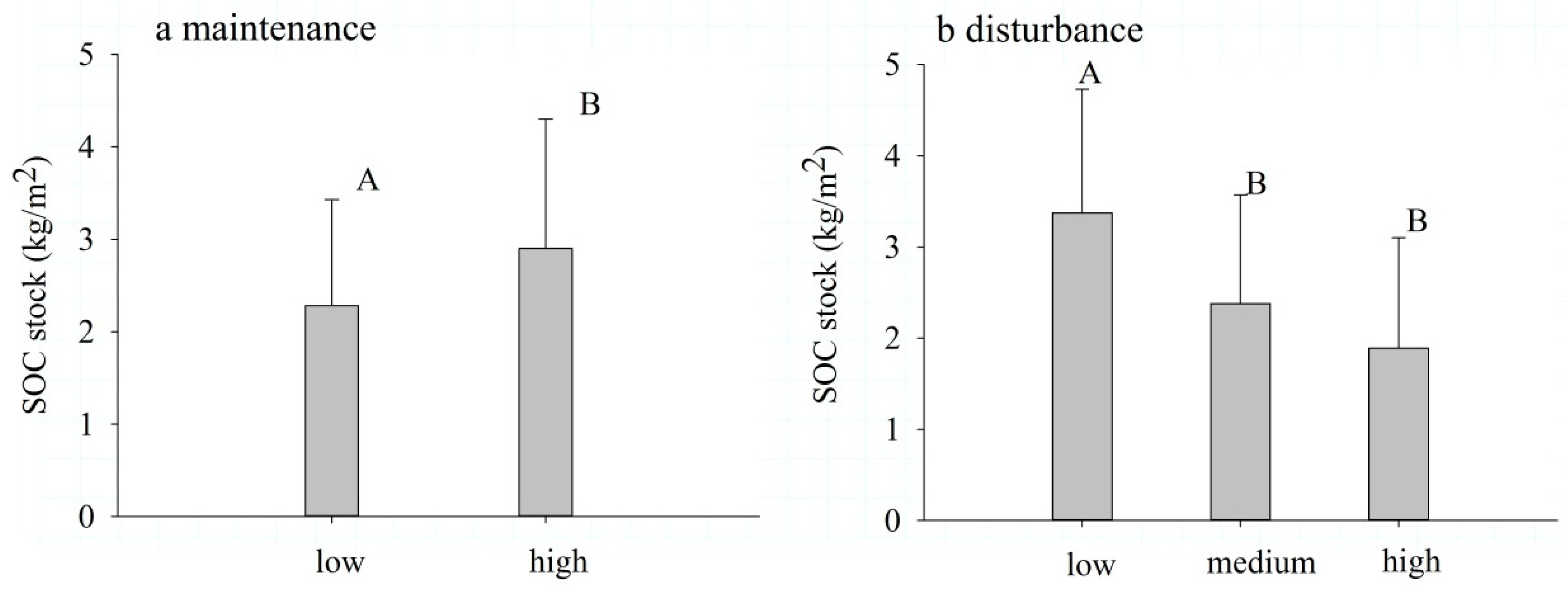
3.3. The Differences in SOC Stock among Maintenance and Disturbance Types

The mean SOC stock in low-maintenance plots (2.28 ± 1.15 kg/m2) was significantly lower than that in high-maintenance plots (2.90 ± 1.40 kg/m2) (Figure 4a). Among the three disturbance intensity types, the low-disturbance intensity had significantly higher SOC stocks (3.37 ± 1.36 kg/m2) than the medium- and high-disturbance intensity. There was no significant difference in SOC stocks between medium- (2.38 ± 1.19 kg/m2) and high- (1.89 ± 1.21 kg/m2) disturbance intensity (Figure 4b). The differences in SOC content of green spaces between maintenance and disturbance intensity types (Figure S3) showed a similar trend in SOC stock.

3.4. Factors Affecting SOC Stock

Simple linear regression analysis showed that SOC stock exhibited a significant positive relationship to plot age (with outliers removed) across all the “young” age classes except for the 2–10 years group (Figure 5a–e). By contrast, except for the 16–87 years group (Figure 5f), all the other “old” age groups showed no significant relationships between SOC stock and plot age (the result of the 21–87 years group is presented in Figure 5g and other data are not shown (p values ranging from 0.23 to 0.87). Plot size also shows a significant positive relationship to SOC stock (Figure 5h).
Multiple linear regression analysis showed that plot size maintained a significant positive effect on SOC stock when the other variables were gradually added. The disturbance maintained a significant negative effect on SOC stock. In contrast, no significant effects of maintenance and plot age (the outliers were not removed) were observed on SOC stock (Table 3).
Stepwise regression analysis showed that only sample plots of latosolic red soil developed from red sandy shale had significantly lower SOC storage than the reference category (soil in the developed land). Only soil samples previously in forest land had significantly more SOC storage than those in historically developed land. However, soil texture, soil type and land use history variables were all removed from the stepwise regression model (Table 3). The drivers entered into the stepwise regression model were plot size and disturbance. All the variables showed a similar trend of effect on SOC content (Figure S4 and Table S1).

4. Discussion

4.1. SOC Content and SOC Stock

Our results showed that urban green space stored SOC content (Table 1) was 49% and 69% lower than that of the young and mature zonal subtropical evergreen forests nearby [49], respectively. This result was comparable to values of 9.07 g/kg and 10.89 g/kg in the nearby cities of Shenzhen [50] and Hong Kong [45], respectively. In Guangzhou, the mean urban green space SOC content in 0–20 cm soil in this study was much lower than that reported by Zhu et al. in a 0–15 cm soil layer (18.22 g/kg) [44] and by Zhuo et al. in a 0–10 cm layer (16.98 g/kg) [43]. The SOC content in public park soils in this study was comparable to the 12.88 g/kg reported by Lu et al. [51]. Soil properties in urban areas are highly heterogeneous [25]. Therefore, the differences in sample plot selection and time span of soil accumulation may contribute to these intra-city differences in SOC content. For example, the average SOC content of the public parks we sampled was 2.66 times higher than that of a newly constructed park [52]. There were several new parks and residential green spaces in our sample plots, which may partly explain the lower than average level of SOC content because of their short accumulation span.
The SOC stock in urban residential soil in Guangzhou (Table 1) was 35% and 42% lower than that in farmland [53] and monsoon evergreen broad-leaved forest soils [54] nearby, respectively, in contrast to the results of Pouyat et al., who found that urban turf grass had much higher SOC density than rural forest soils in Baltimore, USA [11]. Our result was consistent with the result of Chien et al. [55], who found that natural habitats have higher SOC stock than urban habitats by a meta-analysis of global natural and urban soils. The SOC storage in a 0–20 cm soil layer of residential green space in Guangzhou was almost the same as that of the 0–15 cm layer of pure residential lawns in Auburn, USA (2.37 kg/m2) [34], both being humid, subtropical cities. The average urban SOC in green space was much lower than that in Baltimore and Denver, USA (4 to 6 kg/m2 for 0–20 cm) [11], Leicester, UK (9.9 kg/m2 for 0–21 cm) [27], Madison, USA (6.4 to 9.3 kg/m2 for 0–25 cm) [28], Bloomington, USA (4.7 kg/m2 for 0–15 cm) [29], Paris and New York City (9.9 and 11.3 kg/m2, respectively, for 0–30 cm) [56]. Climate and urban-specific factors such as city age, city area, city population and management may all contribute to the intercity variation of urban SOC stocks [13,23]. Some possible reasons for such low SOC in Guangzhou are explicitly discussed in Section 4.2, Section 4.3, Section 4.4 and Section 4.5.

4.2. Plot Age and SOC Storage

Preliminary regressions covering all plots showed that the relationship between SOC and plot age was not significant (p > 0.1, data not shown) except for the group of 2–15 years (Figure 5b). The wrong investigated accumulation span may be the main reason for these insignificant relationships. It is difficult to accurately estimate the time span of SOC accumulation because of the frequent human disturbance. For example, green space reconstruction may lead to a discrepancy between the construction and SOC accumulation span. The earlier green space is built, the easier it is to rebuild in later urban greening campaigns and urban renovation projects, especially green spaces under the management of public departments, such as roadside greenbelts and public parks. Therefore, plots with older age but much low SOC content were removed in this study. Specifically, one 20-year-old residential green space with similar SOC content (5.46 g/kg) to the 5–8-year-old plots, one 25-year-old pocket park and one 23-year-old roadside greenbelt with similar SOC content (2.10 g/kg and 2.30 g/kg, respectively) to the 2-year-old plot, one 23-year-old public park with similar SOC content (4.00 g/kg) to the 5-year-old plots, one 63-year-old roadside greenbelt plot, one 71-year-old park and one 101-year-old public park plot with lower SOC content (3.53 g/kg, 6.18 g/kg and 5.62 g/kg, respectively) than the 10-year-old plots were removed. When these outliers were removed, the relationships between plot age and SOC storage became significant across the age groups of 2–20, 2–35, 2–87 and 16–87 years (Figure 5c–f).
Our results showed that SOC stocks increased with increasing plot age. These results are consistent with previous observations reported by Vasenev et al. [13], Qian and Follett [17], Raciti et al. [18], Contosta et al. [21], Ziter et al. [28], Huyler et al. [33,34], Campbell et al. [35] and Huh et al. [57]. The rate of SOC accumulation in this study declined from 0.18 kg/m2/year in the age group of 2–15 years to 0.03 kg/m2/year in the age group of 2–87 years with the addition of older plots (Figure 5). This result was consistent with the trend observed by previous studies [33]. Qian and Follett found that SOC increased sharply over the first 25–30 years for intensively managed golf courses [17]. Huyler et al. observed that the rapid accumulation of SOC occurred over the first 25 years in less intensively fertilized residential yards [33]. In our study, the rapid accumulation occurred in the 2–15 age groups, and the slope of the 15–87 groups was much lower than that of the pre-35 age groups (Figure 5b–f). The declined slopes suggest positive relationships between SOC storage and plot age in the younger plots [33], consistent with the trend described by SOC stabilization capacity curves in the SOC-saturation model elaborated by Stewart et al. [58]. In Guangzhou city, where rapid urbanization began around the year 1996, 71% of the sampled plots were less than 20 years old and 14% of sampled plots were between 21 and 25 years. Therefore, excluding climate effects [13,23], the short accumulation span can also partly explain why SOC storage in Guangzhou’s urban soil was much lower than that in cities of Western countries, especially in residential green spaces.
It is worth noting that the 2–15 age group had the highest slope (Figure 5b), which was 1.9 and 1.7 times that of the 3–16 and 3–20 age groups observed by Huyler et al. [33], respectively. The SOC accumulation rate of the 2–35 age group (0.048 kg/m2/year) was similar to that of the 3–35 years group observed by Huyler et al. (0.046 kg/m2/year) [33] but lower than the rates observed by Qian and Follett (0.09 kg/m2/year) [17], and Huh et al. (0.07 kg/m2/year) [57]. The possible reason for the higher rate in the 2–15 years group may be the extensive occurrence of topsoil replacement with clean fill soil in Guangzhou, and this fill soil usually originates from deep soil, which was excavated for the construction of building foundations. Clean fill soil usually has fairly low soil organic matter. For example, the SOC storage in the clean fill soil in the USA was 77% lower than that in residential soils at 0–100 cm depth [59] and 75% lower than in urban green space soils at 0–20 cm depth in our dataset (Table 1). Stewart et al. concluded that soils further from SOC saturation would have the greatest efficiency in SOC sequestration [60]. The saturation deficit in deep clean-fill soil was much higher than that in soils converted from farmland or forest. Therefore, the rate of SOC accumulation over 2–15 years in our study was much higher than that in other studies.

4.3. Maintenance and SOC Storage

Studies reported that lawn management practices such as fertilization and irrigation could significantly elevate SOC storage in residential yards compared to yards with less intensive management practices [35] or native landscapes [11]. For all the green space types we studied, the rate of SOC accumulation was relatively lower than that in some Western countries except for in the 2–15 years group. For example, soils of the 2–20 years group in our data accumulated SOC at a rate of 0.076 kg/m2/year at 0–20 cm depth (Figure 5c), which is in accord with soils of 4–58 years with an SOC accumulation rate of 0.082 kg/m2/year at 0–100 cm depth in Baltimore yards [18]. Soils ranging from 2 to 35 years accumulated SOC at 0.048 kg/m2/year at 0–20 cm depth in Guangzhou (Figure 5d), which is in accord with soils of 8–149 years with an SOC accumulation rate of 0.05 kg/m2/year at 0–50 cm depth in Manchester residential yards [21]. Greening species and their related management activities can partially explain this difference. Compared with lawn-dominated residential yards in many Western countries, tree-dominated green spaces in humid Guangzhou do not frequently need irrigation and fertilization. Fertilizer application was assumed to contribute to SOC sequestration by promoting biomass production [35]. However, low frequency of application may not have a significantly measurable effect on SOC storage [33,34].
Our results showed that SOC stocks significantly differed between lowly and highly managed urban green spaces (Figure 4a). The mean SOC storage in residential soils with less intensive management practices was lower than that in roadside greenbelts and public parks with high management intensity (Table 1). Green space management activities and their intensity would also differ according to property rights regimes, such that communal land ownership often results in the “tragedy of the commons” compared with private land ownership [61]. The ownership of green space and its corresponding responsibility subjects and management regimes can largely explain why SOC storage in residential green space was lower than that of public parks and roadside greenbelts and why SOC stocks in Guangzhou residential areas were lower than that of cities in Western countries. Edmondson et al. found that mean SOC stock in domestic gardens was significantly higher than in non-domestic urban green spaces, suggesting that land property regimes affect soil carbon sinks through the initiative and intensity of green space maintenance [27]. In China, all urban green spaces are state-owned land and the municipal government controls and plans urban green space systems under national and provincial legislation. The land use right of residential green space is allocated to all the residents who have bought houses. Property developers plant specific vegetation based on the government-approved residential district plan, and house owners can entrust the house-owner conventions and committees to change greening species and cover types (e.g., pure vegetation or vegetation plus small areas of pervious or impervious pavement). The property management company is responsible for daily maintenance such as irrigation, fertilization and clipping. Individual residents have no direct responsibility for maintaining green space since they have paid the property management fee. Land rights were assumed to affect land production by affecting an individual’s investment incentives [62]. The above green space management system makes it challenging to mobilize residents’ enthusiasm for green space maintenance and conservation and contributes greatly to “the tragedy of the commons” instead.

4.4. Anthropogenic Disturbance and SOC Storage

In this study, the SOC stock of pocket parks with high-disturbance intensity was significantly lower than that of plots with medium and low levels of disturbance (Figure 4b). The difference in mean SOC stock between low- and high-maintenance types was significant (Figure 4a). However, when added as a factor in the multiple regression models, the positive effect of maintenance was not significant. In contrast, plot size and disturbance maintained a significant effect on SOC stock with other variables added to models, and the two variables also remained in the stepwise regression model (Table 3). These results suggest the negative impact of human disturbance on SOC storage in Guangzhou is greater than the positive effect of maintenance. An investigation in Guangzhou reported that services such as providing space for physical exercises, sporting activities, educational opportunities and entertainment in urban green spaces were favored by respondents [63]. The population density in old city districts such as Yuexiu, Liwan, Haizhu and Tianhe is as high as 20,000 to 30,000 people per square kilometer [38], which generates great pressure on urban green spaces, especially pocket parks and residential sites where the elders and children gather daily for physical exercise and recreation. To facilitate the supply of services mentioned above, hard landscapes such as pavement, gravel roads and pavilions are widely used in parks and residential sites, increasing the fragmentation of green space. The coverage rates of impervious surfaces (67%) and buildings (30.07%, 48.68% and 71.75% for high-rise building, low-rise building and urban village plots, respectively) in our study area [64] were much higher than those in Madison, USA [28], which greatly increased the intensity and frequency of human disturbance. This great negative effect from disturbance could also largely explain why the SOC stock in Guangzhou residential green space was much lower than that of residential yards in Western countries.
Anthropogenic disturbances such as trampling-induced soil compaction, litter removal, vegetation destruction and laying of impervious surfaces could decrease SOC input from plant-derived carbon [65]. Nawaz et al. reviewed that soil compaction may change urban soil’s physical, chemical and biogeochemical characteristics, such that soil compaction could increase the soil strength and bulk density, decrease the soil porosity, cause more resistance to penetration, or reduction of aeration, alteration of oxide conditions and pedological processes [66]. These changes would ultimately limit plant growth, decrease soil biodiversity and may define a lower effective SOC sink capacity [35]. The smaller the area of green space is, the more likely it is to be disturbed by trampling and litter removal, and thus SOC accumulation is less likely. Lou et al. found that the average above-ground biomass significantly decreased from large to small patches, and the above-ground biomass in large patches significantly declined from center to edge [67]. The decreasing trend of plant-derived carbon may result in a similar variation in SOC accumulation.

4.5. The Influence of Soil Texture, Soil Type and Land Use History

Soil clay or silt can protect carbon through physical or chemical pathways [68], so soil texture has been examined as an important biogeochemical driver of SOC stock [21,33,34,69,70]. Assuming soil texture and soil type of the 0–20 cm layer did not change drastically after urbanization, we used historical data to explore the influence of soil type and soil texture. Compared with the drivers of plot age and disturbance, our results showed that soil type and soil texture had no significant effect on SOC storage (Table 3). In farmland or natural ecosystem, soil type and texture were always reported as important factors in SOC storage [71,72]. However, the biogeochemical factors in urban ecosystems are under human control, such as engineering, urban demographic trends and household scale actions, which make urban ecosystems different from farmland or natural ecosystems [36].
Soil excavation depth in Guangzhou city is generally not less than 100 cm for the construction of multi-unit building foundations or even 300 cm for the construction of underground parking lots [64]. The volume of soil excavation in residential plots is usually large and difficult to pile up in situ because of limited space. Backfill soils used in many residential green spaces are excavated deep-soil from other construction sites. This is different from that in parks or roadside greenbelts, which may use the original soil piled up in situ. By taking the average clay and silt contents of each green space type reported by Zhu et al. [44] as a reference, the influence of clay and silt content on SOC was also found to be insignificant (Table S2). Construction practices such as extensive original topsoil removal and later backfill of clean soil could reduce the differences in soil texture and soil type because the usual fill-soil in Guangzhou is weathered granite soil which is excavated from high-building foundation pits. Delbecque et al. [73] found that urban soil properties were strongly influenced by compositional differences between native or human-transported parent material types. Therefore, the impacts of soil texture and soil type on SOC accumulation in the topsoil were weakened in the present study. This result was consistent with other studies on the urban system. For example, Contosta et al. observed no correlation between SOC stock and soil silt content of urban residential yards in Manchester, USA and yard management practices were regarded as a possible explanation [21]. In residential yards of Auburn, USA, the insignificant correlation between SOC stock and clay content was attributed to the low clay content and humid-subtropical climate [33,34].
Current and historical land use may all influence SOC sequestration in the urban landscape [28]. For example, for current land use in Madison, USA, Ziter et al. [28] reported that open spaces (parks, golf courses and cemeteries) and residential areas had higher SOC stocks than forests and grasslands, but SOC did not differ between open spaces and residential areas. In our study, we also found that the SOC storage did not vary significantly between residential land and parks (Figure 2b,d). Delbecque et al. [73] also found no significant difference in SOC content among parks, residential areas and industry and services land in Ghent, Belgium, while a globally comparative analysis showed that functional zoning dominated the intracity variability of SOC stocks with large SOC storage in residential areas [13]. For technosols globally, industrial land had significantly higher SOC content than mine and urban land [23]. It has been noted that climate and urban-specific factors such as city age, city area, city population and land cover may all contribute to the intercity variation of urban SOC stocks [13,23].
Compared with current land use, few studies have focused on how historical land use influences urban SOC storage [28]. Raciti et al. [18] reported that residential soil in former agricultural land had a significant capacity to sequester carbon compared with soil in previously forested land and high SOC storage in historically agricultural land has also been reported by Ziter et al. [28]. In our study, only green space soils in previously forested land had higher SOC storage than soils in historically developed land. This may relate to the intensity of human soil modification that was differentiated among site geomorphologies. Compositional differences between native or human-transported parent material types strongly influence urban soil properties, and pre-urban geomorphology is indicative of parent material type and human soil modifications [73]. The geomorphology of historically forested lands in Guangzhou indicates they were usually small hills which were often preserved with slight human soil modifications. However, compared with the variables of plot size and disturbance, most of the historical land use types had no significant influence. This result cannot definitively rule out the impact of land use history on SOC storage in urban green spaces. Frequent human disturbances and soil backfilling make it more intractable to accurately analyze the effects of land-use history.

4.6. Limitations and Future Implications

We did not sample bulk density in our investigation. The bulk densities we used in SOC stock calculation were averaged values from references, leading to certain biases in SOC values. According to previous observations, the bulk density ranged from 0.86 to 1.61 g/cm3 in the 0–10 cm soil layer in urban green spaces [43] and 0.68 to 1.64 g/cm3 for the 0–15 cm soil layer [44], with an average value of 1.38 g/cm3 and 1.31 g/cm3, respectively. Based on the above bulk density intervals, the highest overestimates and underestimates of SOC stock were 50% and 19%, respectively, according to Equation (1). Zhuo et al. reported that 72% of sampled plots had a bulk density higher than 1.30 g/cm3, and the average values for soils in commercial districts, road greenbelts, old and new industrial zones, old and new residential areas and public parks were 1.46, 1.37, 1.33, 1.36, 1.39, 1.37 and 1.40 g/cm3, respectively [43]. Therefore, the underestimated probability of SOC stock was small. For pocket parks with heavier trampling than other green space types, the average value of 1.38 g/cm3 estimated in this study would underestimate SOC storage. In the green space in commercial districts, also with heavy trampling, the SOC stock of the pocket parks would increase by 6% when the bulk density value of 1.46 g/cm3 [43] was used. The bulk density of roadside green space is relatively large. For example, the bulk density of soils in roadside green space in Hong Kong ranged from 1.43 to 2.63 g/cm3, with an average value of 1.67 g/cm3 [74]. However, this survey was conducted on roadside soil pits, not covered in our investigation. Sampled plots in our investigation were relatively large patches of green space under viaducts or greenbelts distributed in the middle or one side of the road, and we did not see obvious signs of heavy trampling in these roadside green spaces. Certain biases may also appear in the analysis of drivers of SOC stock. However, the differences in SOC content between types of maintenance, disturbance and green space all showed a similar trend in SOC stock (Figure 2, Figure 4 and Figure S3), and all the drivers showed a similar trend of effect on SOC content (Figure 5 and Figure S4, Table 3 and Table S1). These similar trends implied that the drivers could actively affect SOC sequestration in urban soils.
We did not measure soil texture in the present study. Remote sensing combined with machine learning methods can model clay content [75,76] but needs a large number of sample data. In this study, the analyzed soil type and soil texture data were reported in earlier years. Using historical soil type and soil texture data could lead to certain biases in the mechanism analysis of carbon dynamics. However, the soil layer we focused on was the topsoil in urban green spaces, which contained a certain volume of backfill soil. Many green space construction projects use backfill soil from similar parent material, which can reduce the spatial heterogeneity of soil texture and soil type. For example, previous studies in Guangzhou reported that loam soil accounted for more than 93% of soil texture types in the topsoil of urban green spaces [43,44]. In urban green spaces of different urban land use types, the clay, silt and sand content in the 0–10 cm soil layer ranged from 4.34 to 5.34%, 36.18 to 49.64% and 45.02 to 59.46%, respectively [44]. Undoubtedly, only extensive field investigation can provide more precise information on the mechanisms of SOC dynamics in urban soils.

5. Conclusions

The total urban SOC storage in the 0–20 cm layer in Guangzhou did not vary significantly among the four green space types, with an average value of 2.59 ± 1.31 kg/m2. SOC increased with plot age, but the sequestration rate declined with time, with the highest sequestration rate of 0.177 kg/m2/year in plots aged 2–15 years, followed by 0.076, 0.048 and 0.025 kg/m2/year in the 2–20, 2–35 and 2–87 years groups, respectively. SOC sequestration also increased with plot size (63–2058 m2) by 0.001 kg/m2/m2 (p = 0.026). The average SOC storage and accumulation rates in Guangzhou were lower than those in many cities in Western countries. Short time span, disturbances due to large population density and fragmentation of green space, less intensive management due to tree-dominated vegetation species and the lack of house-owner-orientated, incentive-based residential green space management regimes may all partially contribute to this relatively low SOC storage. Maintenance practices such as irrigation and fertilization can also promote SOC sequestration in Guangzhou city. In contrast, high-intensity disturbances such as increasing fragmentation of green spaces and trampling caused by many visitors could heavily reduce the capacity of SOC accumulation and largely offset management-induced SOC increases. Therefore, disturbance has become a key factor in SOC storage in Guangzhou. Many green spaces in Guangzhou were built in the past 20 years, so they have a great potential to sequestrate SOC, especially in the widely distributed residential land. In the future, measures should be taken to increase SOC storage, such as composting locally sourced litters, reducing fragmentation of green space and planting trampling-tolerant lawn species. In the long run, these measures will bring long-term benefits to SOC storage in residential green spaces by improving the current residential green space management regimes to encourage house owners to maintain and conserve residential green spaces.

Supplementary Materials

The following supporting information can be downloaded at: https://www.mdpi.com/article/10.3390/land11091484/s1, Figure S1: Some photos of the urban green spaces and soil samples; Figure S2: The methodology flowchart; Figure S3: Differences in SOC content (g/kg) between (a) maintenance and (b) disturbance intensity types; Figure S4: Relationship of SOC content (g/kg) to plot age (2–101 years) in age groups: 2–10 years (a), 2–15 years (b), 2–20 years (c), 2–35 years (d), 2–87 years (e), 16–87 years (f), 21–87 years (g) and to plot size (63–2058 m2) (h); Table S1: Regression analysis of SOC content (g/kg) across all sampled plots; Table S2: Stepwise regression analysis of SOC stock (kg/cm2) to plot size, maintenance, disturbance, plot age and soil texture across all sampled plots.

Author Contributions

Conceptualization, J.D. and M.Y.; methodology, J.D. and M.Y.; software, J.D. and M.Y.; validation, Z.Y. and M.Y.; investigation, J.D., Z.Y. and M.Y.; writing—original draft preparation, J.D.; writing—review and editing, M.Y., Z.Y., H.L. and Y.C.; funding acquisition, M.Y., Z.Y. and Y.C. All authors have read and agreed to the published version of the manuscript.

Funding

This study was supported by the National Science Fund for Distinguished Young Scholars (41825020), Guangdong Basic and Applied Basic Research Foundation (2021A1515012147), the China Postdoctoral Science Foundation (2020M672863) and Guangdong Soft Science Research Foundation (2019A101002046).

Institutional Review Board Statement

Not applicable.

Informed Consent Statement

Not applicable.

Data Availability Statement

The data that support the findings of this study are available from the corresponding author upon request.

Acknowledgments

We thank H. Li for her help with laboratory soil carbon measurements, Z. Wu for his help in the impervious surface extraction and S. Kong, W. Liang and Z. Liang for their help with soil sample.

Conflicts of Interest

The authors declare no conflict of interest.

References

  1. Schneider, A.; Friedl, M.A.; Potere, D. A new map of global urban extent from MODIS satellite data. Environ. Res. Lett. 2009, 4, 44003–44011. [Google Scholar] [CrossRef]
  2. Gurney, K.R.; Romero-Lankao, P.; Seto, K.C.; Hutyra, L.R.; Duren, R.; Kennedy, C.; Grimm, N.B.; Ehleringer, J.R.; Marcotullio, P.; Hughes, S.; et al. Climate change: Track urban emissions on a human scale. Nature 2015, 525, 179–181. [Google Scholar] [CrossRef] [PubMed]
  3. Seto, K.C.; Güneralp, B.; Hutyra, L.R. Global forecasts of urban expansion to 2030 and direct impacts on biodiversity and carbon pools. Proc. Natl. Acad. Sci. USA 2012, 109, 16083–16088. [Google Scholar] [CrossRef]
  4. United Nations. World Urbanization Prospects: The 2018 Revision; United Nations: New York, NY, USA, 2019. [Google Scholar]
  5. Milner, J.; Davies, M.; Wilkinson, P. Urban energy, carbon management (low carbon cities) and co-benefits for human health. Curr. Opin. Environ. Sustain. 2012, 4, 398–404. [Google Scholar] [CrossRef]
  6. Zhang, L.; Yang, L.; Zohner, C.M.; Crowther, T.W.; Li, M.; Shen, F.; Guo, M.; Qin, J.; Yao, L.; Zhou, C. Direct and indirect impacts of urbanization on vegetation growth across the world’s cities. Sci. Adv. 2022, 8, eabo0095. [Google Scholar] [CrossRef]
  7. Nowak, D.J.; Greenfield, E.J.; Hoehn, R.E.; Lapoint, E. Carbon storage and sequestration by trees in urban and community areas of the United States. Environ. Pollut. 2013, 178, 229–236. [Google Scholar] [CrossRef]
  8. Sun, Y.; Xie, S.; Zhao, S. Valuing urban green spaces in mitigating climate change: A city-wide estimate of aboveground carbon stored in urban green spaces of China’s Capital. Glob. Chang. Biol. 2019, 25, 1717–1732. [Google Scholar] [CrossRef]
  9. Edmondson, J.L.; Davies, Z.G.; McHugh, N.; Gaston, K.J.; Leake, J. Organic carbon hidden in urban ecosystems. Sci. Rep. 2012, 2, 963. [Google Scholar] [CrossRef]
  10. Golubiewski, N.E. Urbanization increases grassland carbon pools: Effects of landscaping in Colorado’s Front Range. Ecol. Appl. 2006, 16, 555–571. [Google Scholar] [CrossRef]
  11. Pouyat, R.V.; Yesilonis, I.; Golubiewski, N.E. A comparison of soil organic carbon stocks between residential turf grass and native soil. Urban Ecosyst. 2009, 12, 45–62. [Google Scholar] [CrossRef]
  12. Raciti, S.M.; Hutyra, L.R.; Finzi, A.C. Depleted soil carbon and nitrogen pools beneath impervious surfaces. Environ. Pollut. 2012, 164, 248–251. [Google Scholar] [CrossRef] [PubMed]
  13. Vasenev, V.; Kuzyakov, Y. Urban soils as hot spots of anthropogenic carbon accumulation: Review of stocks, mechanisms and driving factors. Land Degrad. Dev. 2018, 29, 1607–1622. [Google Scholar] [CrossRef]
  14. Wei, Z.; Wu, S.; Zhou, S.; Li, J.; Zhao, Q. Soil organic carbon transformation and related properties in urban soil under impervious surfaces. Pedosphere 2014, 24, 56–64. [Google Scholar] [CrossRef]
  15. Lu, C.; Kotze, D.J.; Setälä, H.M. Soil sealing causes substantial losses in C and N storage in urban soils under cool climate. Sci. Total Environ. 2020, 725, 138369. [Google Scholar] [CrossRef]
  16. Churkina, G. The Role of Urbanization in the Global Carbon Cycle. Front. Ecol. Evol. 2016, 3, 144. [Google Scholar] [CrossRef]
  17. Qian, Y.; Follett, R.F. Assessing Soil carbon sequestration in turfgrass systems using long-term soil testing data. Agron. J. 2002, 94, 930–935. [Google Scholar] [CrossRef]
  18. Raciti, S.M.; Groffman, P.; Jenkins, J.C.; Pouyat, R.V.; Fahey, T.J.; Pickett, S.T.A.; Cadenasso, M.L. Accumulation of carbon and nitrogen in residential soils with different land-use histories. Ecosystems 2011, 14, 287–297. [Google Scholar] [CrossRef]
  19. Smith, R.M.; Williamson, J.C.; Pataki, D.E.; Ehleringer, J.; Dennison, P. Soil carbon and nitrogen accumulation in residential lawns of the Salt Lake Valley, Utah. Oecologia 2018, 187, 1107–1118. [Google Scholar] [CrossRef]
  20. Lu, C.; Kotze, D.J.; Setälä, H.M. Evergreen trees stimulate carbon accumulation in urban soils via high root production and slow litter decomposition. Sci. Total Environ. 2021, 774, 145129. [Google Scholar] [CrossRef]
  21. Contosta, A.R.; Lerman, S.B.; Xiao, J.; Varner, R.K. Biogeochemical and socioeconomic drivers of above- and below-ground carbon stocks in urban residential yards of a small city. Landsc. Urban Plan. 2020, 196, 103724. [Google Scholar] [CrossRef]
  22. Canedoli, C.; Ferrè, C.; Abu El Khair, D.; Padoa-Schioppa, E.; Comolli, R. Soil organic carbon stock in different urban land uses: High stock evidence in urban parks. Urban Ecosyst. 2019, 23, 159–171. [Google Scholar] [CrossRef]
  23. Allory, V.; Séré, G.; Ouvrard, S. A meta-analysis of carbon content and stocks in Technosols and identification of the main governing factors. Eur. J. Soil Sci. 2021, 73, e13141. [Google Scholar] [CrossRef]
  24. Anne, B.; Geoffroy, S.; Cherel, J.; Warot, G.; Marie, S.; Noël, C.J.; Louis, M.J.; Christophe, S. Towards an operational methodology to optimize ecosystem services provided by urban soils. Landsc. Urban Plan. 2018, 176, 1–9. [Google Scholar] [CrossRef]
  25. Morel, J.L.; Chenu, C.; Lorenz, K. Ecosystem services provided by soils of urban, industrial, traffic, mining, and military areas (SUITMAs). J. Soils Sediments 2014, 15, 1659–1666. [Google Scholar] [CrossRef]
  26. Riddle, R.L.; Siebecker, M.G.; Weindorf, D.C.; Shaw, R.K.; Scharenbroch, B.C. Soils in urban and built environments: Pedogenic processes, characteristics, mapping, and classification. Adv. Agron. 2022, 173, 227–255. [Google Scholar] [CrossRef]
  27. Edmondson, J.L.; Davies, Z.G.; McCormack, S.A.; Gaston, K.J.; Leake, J. Land-cover effects on soil organic carbon stocks in a European city. Sci. Total Environ. 2014, 472, 444–453. [Google Scholar] [CrossRef] [PubMed]
  28. Ziter, C.; Turner, M.G. Current and historical land use influence soil-based ecosystem services in an urban landscape. Ecol. Appl. 2018, 28, 643–654. [Google Scholar] [CrossRef] [PubMed]
  29. Schmitt-Harsh, M.; Mincey, S.K.; Patterson, M.; Fischer, B.C.; Evans, T.P. Private residential urban forest structure and carbon storage in a moderate-sized urban area in the Midwest, United States. Urban For. Urban Green. 2013, 12, 454–463. [Google Scholar] [CrossRef]
  30. Sun, Y.; Ma, J.; Li, C. Content and densities of soil organic carbon in urban soil in different function districts of Kaifeng. J. Geogr. Sci. 2010, 20, 148–156. [Google Scholar] [CrossRef]
  31. Liu, Y.; Wang, C.; Yue, W.; Hu, Y. Storage and density of soil organic carbon in urban topsoil of hilly cities: A case study of Chongqing Municipality of China. Chin. Geogr. Sci. 2013, 23, 26–34. [Google Scholar] [CrossRef]
  32. Cambou, A.; Saby, N.P.; Hunault, G.; Nold, F.; Cannavo, P.; Schwartz, C.; Vidal-Beaudet, L. Impact of city historical management on soil organic carbon stocks in Paris (France). J. Soils Sediments 2021, 21, 1038–1052. [Google Scholar] [CrossRef]
  33. Huyler, A.; Chappelka, A.H.; Prior, S.A.; Somers, G.L. Influence of aboveground tree biomass, home age, and yard maintenance on soil carbon levels in residential yards. Urban Ecosyst. 2014, 17, 787–805. [Google Scholar] [CrossRef]
  34. Huyler, A.; Chappelka, A.H.; Prior, S.A.; Somers, G.L. Drivers of soil carbon in residential ‘pure lawns’ in Auburn, Alabama. Urban Ecosyst. 2013, 17, 205–219. [Google Scholar] [CrossRef]
  35. Campbell, C.D.; Seiler, J.R.; Wiseman, P.E.; Strahm, B.D.; Munsell, J.F. Soil carbon dynamics in residential lawns converted from Appalachian mixed oak stands. Forests 2014, 5, 425–438. [Google Scholar] [CrossRef]
  36. Kaye, J.P.; Groffman, P.M.; Grimm, N.; Baker, L.A.; Pouyat, R.V. A distinct urban biogeochemistry? Trends Ecol. Evol. 2006, 21, 192–199. [Google Scholar] [CrossRef] [PubMed]
  37. Li, H.; Chen, W.; He, W. Planning of green space ecological network in urban areas: An example of Nanchang, China. Int. J. Environ. Res. Public Health 2015, 12, 12889–12904. [Google Scholar] [CrossRef]
  38. Statistics Bureau of Guangzhou City. Guangzhou Statistical Yearbook of 2020 and 2000; China Statistics Press: Beijing, China, 2021. Available online: http://112.94.72.17/portal/queryInfo/statisticsYearbook/index (accessed on 7 February 2021).
  39. Soil Census Office of Guangdong Province. Soils of Guangdong Province, 1st ed.; Science Press: Beijing, China, 1996; p. 103.
  40. Wiesmeier, M.; Urbanski, L.; Hobley, E.; Lang, B.; von Lützow, M.; Marin-Spiotta, E.; van Wesemael, B.; Rabot, E.; Ließ, M.; Garcia-Franco, N.; et al. Soil organic carbon storage as a key function of soils—A review of drivers and indicators at various scales. Geoderma 2018, 333, 149–162. [Google Scholar] [CrossRef]
  41. Nelson, D.W.; Sommers, L.E. Total carbon, organic carbon, and organic matter. In Methods of Soil Analysis; Sparks, D., Page, A., Helmke, P., Loeppert, R., Soltanpour, P.N., Tabatabai, M.A., Johnston, C.T., Sumner, M.E., Eds.; Wiley: Hoboken, NJ, USA, 1996. [Google Scholar] [CrossRef]
  42. Guan, D.; He, K.; Chen, Y. The soil characteristics of Guangzhou urban vegetation and its effects on tree growth. Chin. J. Res. Environ. Sci. 1998, 11, 51–54. [Google Scholar] [CrossRef]
  43. Zhuo, W.; Tang, J.; Guan, D. A study on the soil properties of urban green space in Guangzhou and the impact of human activities on them. Chin. J. Acta Sci. Nat. Univ. Sunyatseni 2007, 46, 32–35. [Google Scholar] [CrossRef]
  44. Zhu, C.; Xiong, Y.; He, M.; Feng, Y. Soil physico-chemical properties and their correlations in a greenbelt in Guangzhou. Chin. J. Ecol. Environ. Sci. 2010, 19, 1868–1871. [Google Scholar] [CrossRef]
  45. Jim, C.Y. Soil Characteristics and management in an urban park in Hong Kong. Environ. Manag. 1998, 22, 683–695. [Google Scholar] [CrossRef] [PubMed]
  46. Zhang, Y. The Carbon Footprint Accounting and Assessment Study of Guangzhou Typical Urban Green Space; Huazhong Agricultural University: Wuhan, China, 2013; p. 6. [Google Scholar]
  47. Soil Census Office of Guangdong Province. Soil Chorography of Guangdong Province, 1st ed.; Science Press: Beijing, China, 1996; pp. 92, 120, 125, 252, 280, 288, 390, 408, 410.
  48. Xu, X.; Liu, J.; Zhang, S.; Li, R.; Yan, C.; Wu, S. China’s Multi-Period Land Use/Cover Remote Sensing Monitoring Dataset (CNLUCC); Data Registration and Publishing System of the Resource and Environmental Science Data Center of the Chinese Academy of Sciences: Beijing, China, 2018. [Google Scholar] [CrossRef]
  49. Zhang, X.; Guan, D.; Li, H.; Huang, K.; Xu, Z. Allocation characteristic of organic carbon pool in typical forest soils in Guangzhou. Chin. J. Acta Sci. Nat. Univ. Sunyatseni 2009, 48, 137–142. [Google Scholar] [CrossRef]
  50. Lu, Y.; Gan, H.; Shi, Z.; Liu, Z. Soil fertility quality assessment and managing measures for urban green space in Shenzhen city. Chin. J. Soil Water Conserv. 2005, 19, 153–156. [Google Scholar] [CrossRef]
  51. Lu, Y.; Feng, H.; Gan, H. Soil fertility characteristics and enzyme activity for urban parks in Guangzhou City. Chin. J. Soil Water Conserv. 2007, 21, 160–163. [Google Scholar] [CrossRef]
  52. He, Z.; Huang, L.; Cheng, H.; Wang, J. Soil fertility evaluation and related soil improvement and utilization of Nansha seaside park in Guangzhou. Chin. J. Guangdong For. Sci. Technol. 2001, 27, 51–54. [Google Scholar] [CrossRef]
  53. Wu, Z.; Huang, Y.; Jiang, C. Soil and vegetation carbon storage and its spatial pattern analysis of Guangzhou City, China. Chin. J. Guangzhou Univ. Nat. Sci. Ed. 2014, 13, 73–79. [Google Scholar]
  54. Fang, Y.; Mo, J.; Sandra, B.; Zhou, G.; Zhang, Q.; Li, D. Storage and distribution of soil organic carbon in Dinghushan Biosphere Reserve. Chin. J. Acta Ecol. Sin. 2004, 24, 135–142. [Google Scholar] [CrossRef]
  55. Chien, S.-C.; Krumins, J.A. Natural versus urban global soil organic carbon stocks: A meta-analysis. Sci. Total Environ. 2021, 807, 150999. [Google Scholar] [CrossRef]
  56. Cambou, A.; Shaw, R.K.; Huot, H.; Vidal-Beaudet, L.; Hunault, G.; Cannavo, P.; Nold, F.; Schwartz, C. Estimation of soil organic carbon stocks of two cities, New York City and Paris. Sci. Total Environ. 2018, 644, 452–464. [Google Scholar] [CrossRef] [Green Version]
  57. Huh, K.Y.; Deurer, M.; Sivakumaran, S.; McAuliffe, K.; Bolan, N.S. Carbon sequestration in urban landscapes: The example of a turfgrass system in New Zealand. Soil Res. 2008, 46, 610–616. [Google Scholar] [CrossRef]
  58. Stewart, C.E.; Paustian, K.; Conant, R.; Plante, A.; Six, J. Soil carbon saturation: Concept, evidence and evaluation. Biodegradation 2007, 86, 19–311. [Google Scholar] [CrossRef]
  59. Pouyat, R.V.; Yesilonis, I.D.; Nowak, D.J. Carbon storage by urban soils in the United States. J. Environ. Qual. 2006, 35, 1566–1575. [Google Scholar] [CrossRef] [PubMed]
  60. Stewart, C.E.; Paustian, K.; Conant, R.T.; Plante, A.F.; Six, J. Soil carbon saturation: Evaluation and corroboration by long-term incubations. Soil Biol. Biochem. 2008, 40, 1741–1750. [Google Scholar] [CrossRef]
  61. Hardin, G. The Tragedy of the Commons. Science 1968, 162, 1243–1248. [Google Scholar] [CrossRef] [PubMed]
  62. Alchian, A.A.; Demsetz, H. Production, information costs, and economic organization. Am. Econ. Rev. 1972, 62, 777–795. [Google Scholar] [CrossRef]
  63. Chen, S.; Wang, Y.; Ni, Z.; Zhang, X.; Xia, B. Benefits of the ecosystem services provided by urban green infrastructures: Differences between perception and measurements. Urban For. Urban Green. 2020, 54, 126774. [Google Scholar] [CrossRef]
  64. Du, J.; Yu, M.; Yan, J. The Impact of impervious surface expansion on soil organic carbon: A case study of 0–300 cm soil layer in Guangzhou city. Sustainability 2021, 13, 7901. [Google Scholar] [CrossRef]
  65. Luo, S.; Mao, Q.; Ma, K.; Wu, J. A review of carbon cycling and sequestration in urban soils. Chin. J. Acta Ecol. Sin. 2012, 32, 7177–7189. [Google Scholar] [CrossRef]
  66. Nawaz, M.F.; Bourrié, G.; Trolard, F. Soil compaction impact and modelling. A review. Agron. Sustain. Dev. 2012, 33, 291–309. [Google Scholar] [CrossRef] [Green Version]
  67. Lou, D.; Chen, Y.; Liu, K.; Chen, Y.; Ma, L.; Yu, C.; Guan, D. Effects of patch size variation on biomass in Fengshui forest in east Guangzhou. Acta Sci. Nat. Univ. Sunyatseni 2019, 58, 12–21. [Google Scholar] [CrossRef]
  68. Six, J.; Conant, R.T.; Paul, E.A.; Paustian, K. Stabilization mechanisms of soil organic matter: Implications for C-saturation of soils. Plant Soil 2002, 241, 155–176. [Google Scholar] [CrossRef]
  69. McLauchlan, K.K. Effects of soil texture on soil carbon and nitrogen dynamics after cessation of agriculture. Geoderma 2006, 136, 289–299. [Google Scholar] [CrossRef]
  70. Trammell, T.L.E.; Pouyat, R.V.; Carreiro, M.M.; Yesilonis, I. Drivers of soil and tree carbon dynamics in urban residential lawns: A modeling approach. Ecol. Appl. 2017, 27, 991–1000. [Google Scholar] [CrossRef] [PubMed]
  71. Mayes, M.; Marin-Spiotta, E.; Szymanski, L.; Erdoğan, M.A.; Ozdoğan, M.; Clayton, M. Soil type mediates effects of land use on soil carbon and nitrogen in the Konya Basin, Turkey. Geoderma 2014, 232–234, 517–527. [Google Scholar] [CrossRef]
  72. Stockmann, U.; Adams, M.A.; Crawford, J.W.; Field, D.J.; Henakaarchchi, N.; Jenkins, M.; Minasny, B.; McBratney, A.B.; de Courcelles, V.d.R.; Singh, K.; et al. The knowns, known unknowns and unknowns of sequestration of soil organic carbon. Agric. Ecosyst. Environ. 2013, 164, 80–99. [Google Scholar] [CrossRef]
  73. Delbecque, N.; Dondeyne, S.; Gelaude, F.; Mouazen, A.M.; Vermeir, P.; Verdoodt, A. Urban soil properties distinguished by parent material, land use, time since urbanization, and pre-urban geomorphology. Geoderma 2022, 413, 115719. [Google Scholar] [CrossRef]
  74. Jim, C.Y. Physical and chemical properties of a Hong Kong roadside soil in relation to urban tree growth. Urban Ecosyst. 1998, 2, 171–181. [Google Scholar] [CrossRef]
  75. Zhao, D.; Wang, J.; Zhao, X.; Triantafilis, J. Clay content mapping and uncertainty estimation using weighted model averaging. Catena 2021, 209, 105791. [Google Scholar] [CrossRef]
  76. Zhao, D.; Zhao, X.; Khongnawang, T.; Arshad, M.; Triantafilis, J. A Vis-NIR spectral library to predict clay in Australian cotton growing soil. Soil Sci. Soc. Am. J. 2018, 82, 1347–1357. [Google Scholar] [CrossRef]
Figure 1. Location of Guangzhou city and sampling site distribution.
Land 11 01484 g001
Figure 2. Interval distributions of SOC contents (a) and SOC stocks (c) across green space types; SOC contents (b) and SOC stocks (d) across land covers. Different letters denote significant differences among green space types at p < 0.05.
Land 11 01484 g002
Figure 3. Land use types of sample plots in the study area in 1990.
Land 11 01484 g003
Figure 4. Differences in SOC stock between (a) maintenance and (b) disturbance intensity classes. Thirty-six plots for low- and high-maintenance classes, respectively, and 18, 48 and 6 plots for low-, medium- and high-intensity disturbance groups, respectively. Different letters denote significant differences among maintenance or disturbance intensity types at p < 0.05.
Land 11 01484 g004
Figure 5. Relationship of stock (kg/m2) to plot age (2–101 years) of age groups: 2–10 years (a), 2–15 years (b), 2–20 years (c), 2–35 years (d), and 2–87 years (e), 16–87 years (f), 21–87 years (g) and to plot size (63–2058 m2) (h). Plots with older age but much lower SOC content were removed. A total of 1, 4, 7, 7 and 7 outliers were removed from the 2–20 years (c), 2–35 years (d), 2–87 years (e), 16–87 years (f) and 21–87 years (g) groups, respectively. The outliers removed from the former age group were also removed from the latter.
Land 11 01484 g005
Table 1. SOC content and stock in different green space types (mean ± SE).
Type of Green SpaceSOC Content (g/kg)SOC Stock (kg/m2)N
Residential green space9.12 ± 4.27 a2.41 ± 1.13 a34
Public park10.43 ± 5.00 a2.75 ± 1.32 a17
Pocket park7.17 ± 4.60 a1.89 ± 1.21 a6
Roadside greenbelt11.70 ± 6.09 a3.09 ± 1.61 a15
Clean fill soil #2.41 ± 0.45 b0.64 ± 0.12 b4
Average value of green spaces9.80 ± 4.92.59 ± 1.3172 $
Soil samples from universities were grouped into residential green spaces with similar maintenance. # Assume this fill soil is used for greening, and values of the bulk density and the volume ratio of gravel greater than 2 mm in diameter are the same as green space. Different letters denote significant differences among green space types at p < 0.05. $ The total number of green space plots.
Table 2. Soil clay and silt content of different soil types in the study site in 1985.
Soil TypeClay Content
(%)
Silt Content
(%)
Clay + Silt Content
(%)
Number of Sample Site
Soil in the developed land4.8443.4248.2632
Latosolic red soil developed from red sandy shale (shrubberies)22.0724.4146.484
Alluvial soil in a broad valley9.9518.6228.573
Vegetable soil8.3731.6840.0519
Latosolic red soil developed from granite28.4822.0950.573
Fertile paddy soil developed from river-ocean sediments20.134.7454.844
Latosolic red soil developed from red sandy shale (dry farming)15.9416.6532.595
Alluvial soil in river terrace16.6724.8141.482
Table 3. Regression analysis of SOC stock across all sampled plots.
MethodVariablesPartial Regression Coefficientsp Value
EnterPlot size0.0010.067 *
Maintenance0.4900.112
EnterPlot size0.0010.045 **
Disturbance−0.7720.004 ***
EnterPlot size0.0010.057 *
Maintenance0.0810.812
Disturbance−0.7370.016 **
EnterPlot size0.0010.050 **
Maintenance−0.0140.968
Disturbance−0.8070.012 **
Plot age0.0070.403
StepwiseEntered variables
    Constant3.5590.000 ***
    Plot size0.0010.045 **
    Disturbance−0.7720.004 ***
Removed variables
    Maintenance0.0310.812
    Plot age0.0970.382
    Land use history
        Developed land (the reference category)
        Paddy field (rice)0.1160.295
        Irrigated field−0.0430.698
        Forest land0.2120.059 *
        Water−0.0500.653
    Soil type
        Soil in the developed land (the reference category)
        Latosolic red soil developed from red sandy shale (shrubberies)−0.1980.074 *
        Vegetable soil0.0770.489
        Latosolic red soil developed from granite0.1000.372
        Fertile paddy soil developed from granite river- ocean sediments−0.0300.790
        Latosolic red soil developed from red sandy shale (farming)−0.1430.200
        Alluvial soil in river terrace and broad valley0.0780.493
    Clay + silt content0.0620.596
N = 72. *, ** and *** indicate statistical significance at α ≤ 0.10, α ≤ 0.05 and α ≤ 0.01 levels, respectively. Preliminary analysis showed that collinearity occurred when the variables of clay and silt content were entered into the regression model together with other variables. To eliminate this collinearity, we used the summed content of clay and silt in each soil type to explore the influence of soil texture. The adjusted R2 of the stepwise regression model was 0.151. No collinearities occurred in these models. For the variable of soil type, the alluvial soil in river terraces was grouped with the alluvial soil in broad valleys due to sample numbers being less than three.
Publisher’s Note: MDPI stays neutral with regard to jurisdictional claims in published maps and institutional affiliations.

