Abstract
Scientific analysis of the spatial features and driving factors of homestead agglomeration in different landform types of mountainous and hilly areas in Southwest China is of great significance for the optimization of national spatial patterns and high-quality rural development. This paper selects 22 villages in 3 towns with different landform types in Chongqing and examines the spatial features and driving factors of homestead agglomeration in different landform types from the perspectives of terrain gradient, kernel density estimation, farmer household agglomeration status, and landscape index. We analyzed the agglomeration spatial features of different landform types and explored their driving factors and mechanisms. It was found that (1) the distribution of homesteads in mountainous and hilly areas has obvious terrain gradient characteristics, and the layout of platform area homesteads is not constrained by terrain conditions. (2) Chongqing homesteads show a spatially dispersed pattern, but the degree of homestead spatial agglomeration varies significantly among different landform types, with those in mountainous and hilly areas being mainly dispersed and those in platform areas being mainly clustered. (3) Homestead spatial agglomeration is characterized by a combination of factors inside and outside the rural system and farmers’ willingness. There are differences in the driving factors of homestead agglomeration in different landform types. Homestead agglomeration in mountainous and hilly areas is mainly driven externally, while homestead agglomeration in platform areas is mainly driven internally. In both situations, farmers’ willingness must be fully considered. The results of this study can provide a scientific basis for the spatial planning and optimal allocation of land resources in the southwestern hilly area.
1. Introduction
Homesteads are the main settlement form of the rural population [1]. Their spatial layout and optimization are an important part of rural reconstruction [2] and is also a key topic in academia [3,4]. China has entered a critical period of socioeconomic transformation and development. Economic reconstruction, social relationship changes, urban-rural integration, and land system reform are continuously impacting the traditional human-land relationship system in the countryside. Homestead spatial reconstruction is an important way to optimize the spatial pattern of the countryside and improve its spatial governance. In recent years, China has implemented abundant practices for homestead spatial reconstruction, such as “relocating and merging villages” [5], “increasing and decreasing at the same time” [6], “merging villages together” [7], “separation of powers in homestead” [8,9], and so on. However, most of these practices focus on adjusting the physical space pattern to achieve “spatial replacement”. Researchers from various countries have studied the various aspects of the homestead from the point of view of farmers as the subject of homestead use, which has been permeated by a range of non-farm activities and therefore has led to the disappearance of villages due to the relocation of more farmers [10], in addition to the phenomenon of the urban population moving to the countryside, this phenomenon has influenced the spatial changes in the use of the rural homestead [11]. Researchers have also studied homestead use in terms of building color, internal structure, and external space [12,13]. In addition, it has been pointed out that livelihood capital and socio-economic transformation have a strong interactive effect on rural living space [14], and that living space is different from the living environment and should contain social as well as cultural values that are based on the results of social and cultural roles, so scholars have also focused on the neighbors of farm households [15], livability of the elderly [16], mobility of rural community residence of retired university teachers [17], and the well-being and sense of place attachment of farm households, thus building beautiful homes together [18]. The living environment of farmers interacts with the surrounding natural, economic, social, and cultural environments [19]. A comprehensive understanding of homestead agglomeration spatial features and mechanisms requires the integration of human and natural factors into a unified framework for analysis which could provide guidance for the optimal layout of homesteads in the future.
In the context of the agricultural land and homestead “separation of powers” reformation, guiding the homestead to moderate agglomeration is an excellent way to combine “top-down” government intervention and “bottom-up” farmer participation. In the early 1940s, the geographer Yang Renzhang, when examining the homestead layout of the hill area, pointed out that “village houses in the area are mostly distributed on the remnant hills and do not encroach on the farmland where crops are grown” [20]. Over time, although there is a clear trend for homestead space to shift from dispersal to agglomeration [21,22], the current homestead distribution is discrete, with low population density [23]. Overall, the general character of the homestead layout remains highly fragmented, with a large number of small-scale agglomerations [24]. Based on the description of the spatial features of homesteads, scholars have proposed a positive change in the rural territorial system through rural reconfiguration and optimization [2,25,26]. At the same time, it has been pointed out that guiding rural households in mountainous areas to move to hills or plains for moderate agglomeration can help to allocate public service facilities or infrastructure and develop tourism [27]. Moderate homestead agglomeration planning is an important regulatory tool to transform rural settlements from disorder to order. It is also an important tool to solve the dilemma of the construction land shortages while integrating urban and rural resources. In addition, it is conducive to promoting rural revitalization and integrated urban-rural development [28]. Specifically, it can have a significant impact on rural-spatial optimization by reshaping farmer behaviors, institutional structures, and national policies [29], reorganizing rural socioeconomic patterns, and optimizing regional spatial patterns through optimal allocation and effective management. These effects can reduce infrastructure investment costs and optimize the spatial pattern of homesteads by agglomerating originally independent and scattered rural residences to more level and suitable spaces for living and development [30]. Homestead agglomeration characteristics reflect the regional characteristics of the rural human-land relationship system. The selection and use of homesteads by farmers constitute the native landscape of the countryside. By analyzing the homestead spatial features and patterns of different landform types, this study can efficiently promote new urbanization and rural revitalization, factors that are important to Chongqing.
Studies related to rural construction spatial features include the spatial evolution and optimization of the rural residential area [31,32,33], the distribution density of the rural residential area [34], the optimization of the rural residential area [6,35], the spatial reorganization of the rural area [36,37,38], and the siting layout of these areas [39,40,41]. Most of the recent studies consider these rural residential areas as points from a macro perspective. Although some scholars have explained the internal structure and function of these sites at a micro level [42,43], they have predominantly given attention to how well farmer households live together [44,45,46] and optimize their lives [47,48]. The empirical relationship between the social behavior of micro-subjects and polygon features based on homestead polygons has not been sufficiently studied. To this end, this paper uses push-pull theory as the basis, selects towns in the mountain, hill, and platform areas of Chongqing, and applies participatory rural appraisal (PRA) and GIS technology to reveal the spatial features of homestead agglomeration and its main controlling factors by combining the spatial, social, and physical attributes of the homestead and analyzing, from a microscopic perspective, the homestead spatial features and driving factors of homestead agglomeration under different territorial systems of human-land relationships. It also provides a reference for formulating spatial reconstruction strategies that conform to the evolution of rural human-land relations and adapt to the development trend of rural transformation, while offering support and guidance for the improvement of rural spatial governance capacity.
2. Materials and Methods
2.1. Overview of the Study Area
Chongqing is located between 105°11′E~110°11′E, 28°10′N~32°13′N, in the middle of the transition from the Qinghai-Tibet Plateau to the middle and lower reaches of the Yangtze River Plain. The terrain is undulating, as it is high at the south and north ends and low in the Yangtze River valley in the middle zone. Chongqing has many high mountains, such as Daba, Wu, and Qiyao Mountain. There are eight major categories of landform types in Chongqing, namely, middle mountain, low mountain, high hills, medium hills, low hills, gentle hills, mesa, and platform. In this paper, the landforms are divided into three categories: mountains (middle mountains and low mountains), hills (high hills, middle hills, low hills, and slow hills), and platforms (platforms and flat dams). The mountainous region is represented by Zhongyi Town of Shizhu County and Sanjian Town of Fengdu County. The hilly areas are represented by Shitan Town in the Banan District and Zhushan Town in the Liangping District. The platform area is represented by Tai’an Town in the Tongnan District (Figure 1). The basic information about townships and towns is shown in Table 1.
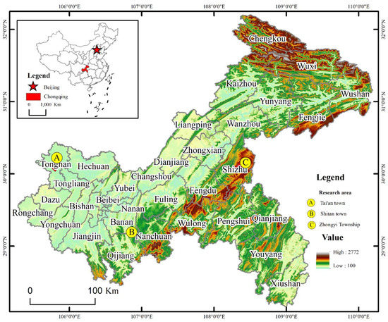
Figure 1.
Schematic diagram of the study area.

Table 1.
Basic information for the selected towns.
2.2. Data Source
The data used in this paper and its sources are as follows. First, homestead data are obtained from local governmental documents, high-definition remote sensing image maps, and the preliminary results of the Third National Land Survey provided by the Ministry of Natural Resources. The homesteads in DLTB are then extracted. Second, the data on the number of farm households corresponding to the homestead polygon are obtained in two ways: high-definition remote sensing images and field research. The data are stored to provide support for the analysis of homestead agglomeration spatial features. (3) DEM data were downloaded from a geospatial data website (http://www.gscloud.cn/. 1 November 2021) with a spatial resolution of 30 m. The elevation and slope data are calculated from DEM data. (4) Socioeconomic data are obtained from official local statistics and our questionnaire. (5) Data on individual farmers’ perceptions and willingness were obtained from field research in each village. A total of 370 questionnaires were obtained, with 348 valid questionnaires and an effective rate of 94.1%. Data on the current status and structure of homestead utilization and farmers’ homestead agglomeration intentions were compiled from the questionnaires. The characteristics of the farm household sample are shown in Table 2.
Table 2.
Characteristic distribution of farmer samples.
2.3. Research Methodology
2.3.1. GIS Spatial Analysis Method
(1) Terrain niche index. A terrain gradient viewpoint was adopted to analyze the homestead spatial distribution in different landform types. Calculations were made by Map Algebra’s Raster Calculator tool in ArcGIS. The terrain niche index is a comprehensive terrain index, and its calculation formula is
where K is the terrain niche index; H and G are elevation and slope values, respectively; and and are the average elevation and average slope values, respectively. The terrain niche index is positively correlated with elevation and slope values [49]. In this paper, the elevation, slope, and terrain niche index were graded with the actual conditions of the case towns and divided into eight grades in turn (Table 3).
Table 3.
Elevation, slope, and terrain niche index in different landform types.
(2) The distribution index, which can reflect the distribution frequency of homesteads in each terrain, is used to describe the distribution of homesteads in certain terrain conditions (elevation, slope, and terrain niche index). The distribution was calculated as follows.
P represents the distribution index, j represents the grade of certain terrain conditions, represents the coverage of the rural residential area in j grade terrain gradient, represents the total coverage of the rural residential area in the whole area, represents the total coverage if j is the terrain gradient in the study units, and represents the total land coverage in the study area. P > 1 means that the distribution of rural residential areas in terrain j is dominant. The larger the P value is, the higher the dominance.
(3) Kernel density estimation. Kernel density estimation (KDE) is a nonparametric surface density estimation method that is often used to analyze the spatial distribution of point-like elements. The higher the value of kernel density is, the denser the distribution of rural residential areas [50]. Its expression is as follows.
represents the estimated density in location (x,y), n represents the number, h represents the bandwidth, k is the kernel function, and d is the distance to the No. i viewing position.
2.3.2. Landscape Pattern and Indices
Landscape pattern indices reflect the structural composition of the homestead landscape and measure the spatial distribution characteristics of its polygon [51]. Homestead number, homestead density, average homestead distance, average homestead polygon population, homestead area per capita, average polygon area, distance index, area index, etc., can quantitatively describe homestead spatial features.
2.3.3. Geographic Detector Model
Geographic detectors are a set of statistical methods for detecting stratified spatial heterogeneity and revealing the driving forces behind it [52]; they are used in this paper to detect the driving factors of homestead agglomeration features in different landform types. The formula is as follows.
represents the detection factors of the homestead agglomeration impact mechanism, represents the sample number of the area in the next level, represents the sample number of the whole area, represents the number of the study areas in the next level, and is the variance of the study area in the next level. The interval of is {0,1}. The larger the value is, the higher the impact of the driving factor. This paper analyses the spatial driving factors of homestead agglomeration by selecting driving factors from three aspects: external driving factors (physical geographic conditions, location conditions, and policies), internal driving factors (population mobility, homestead idleness, village market development, etc.), and farmers’ subjective intentions (Table 4).
Table 4.
The driving factors of homestead agglomeration.
3. Homestead Agglomeration Features in Different Landforms
The spatial agglomeration of homesteads varies in different areas due to different landform types, individual and family characteristics, housing utilization, infrastructure, social interaction, and life, as well as individual subjective perceptions and current conditions of the village. The spatial agglomeration characteristics of homesteads in different landform types are analyzed in terms of terrain gradient, kernel density estimation, farm household agglomeration situation, and landscape pattern index, which provide a basis for an objective and profound understanding of the human-land relationship system in different areas.
3.1. The Terrain Gradient Features of Homesteads
By summarizing the distribution of homesteads in three different landform types on different gradient levels of elevation, slope, and terrain niche index (Figure 2), it can be seen that the distribution index of mountainous and hilly areas shows an overall decreasing trend as the terrain gradient of elevation, slope, and terrain niche index increases, and the distribution index of platform areas show less change. This indicates that the distribution of homesteads in mountainous and hilly areas is more influenced by terrain conditions, while the distribution of homesteads in platform areas is not constrained by terrain conditions. Zhongyi town, which is located in the mountain area, has the best homestead distribution in the area with an elevation level of 1 to 2, i.e., <720 m, slope level of 1 to 4, i.e., <15°, and terrain niche index level of 1 to 3, i.e., <0.515. The hilly area has the best agglomeration in the area with an elevation level of 1, i.e., <649 m, slope level of 1 to 4, i.e., <15°, and terrain niche index level of 1 to 4, i.e., <0.593. The platform area homestead agglomeration is mainly influenced by traffic, location, and other conditions.
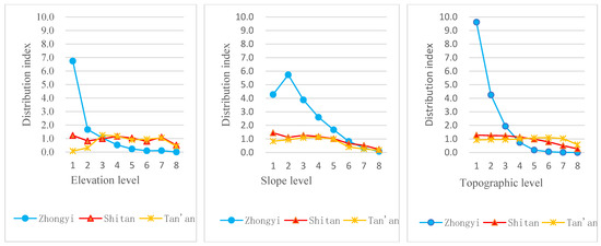
Figure 2.
Homestead distribution index at different gradient levels.
3.2. Homestead Kernel Density Estimation
With the kernel density tool in ARCGIS 10.2, kernel density estimation was performed for three township homesteads. There are three findings. First, the spatial distribution of homesteads within Zhongyi Town, a mountainous township, varies significantly, with high-density areas scattered in a dotted pattern, mainly in Huaxi Village in the central and western part and Jianfeng Village in the east. In addition, high-density areas are also scattered in the southeastern part of Pingba Village and the central part of Quanxing Village. Further analysis combined with remote sensing images and field research shows that the main high-density areas are primarily government-set residential settlements and their surrounding areas and larger-scale natural settlements, such as the residential site in Jianfeng Village, the vicinity of the Rongchuang cluster in Huaxi Village, and the traditional residential area in Quanxing Village (Figure 3-1). Their main distribution is characterized by scattered homesteads (Figure 3-4), while the house structures are mainly all wood (Figure 3-7). Second, the Shitan Town homestead, which is located in a hill area, generally shows a dense distribution in the west and a scattered distribution in the east. Specifically, it is mainly distributed in the south of Shuangzhai Village, the west of Waneng Village, and the west and middle of Fangdu Village. The distribution of the Tiantai village homestead is more fragmented. Homestead distribution densities are mainly located on gently sloping areas with elevations between 650 and 850 m (Figure 3-2). Homesteads are mainly located in areas with lower elevation, flatter terrain, and better infrastructure (Figure 3-5), and the houses are mostly two stories and mainly of brick and concrete construction (Figure 3-8). Third, the distribution of homestead density in platform area towns, such as Tai’an town, possesses some geographical variability, showing a relatively dense pattern in the south and a sparse pattern in the north. Some of the villages in the south of Tai’an Town, such as Tagou Village, Tangshi Village, Tonggu Village, and Yujian Village, have a more contiguous and dense homestead distribution; these villages are mainly located near rivers, at lower elevations and flatter slopes. The distribution of homesteads has a high correlation with rivers and topography (Figure 3-3). Homestead distribution is relatively concentrated (Figure 3-6), with a better economic development advantage and a micro landscape dominated by small farmhouses (Figure 3-9)
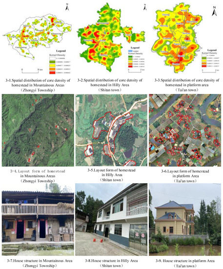
Figure 3.
Characteristics of homestead features in different landscapes of Chongqing. Note: 3-1, 3-2 and 3-3 are nuclear density analysis diagrams of different geomorphic types; 3-4, 3-5 and 3-6 are layout form of homestead in different geomorphic types; 3-7, 3-8 and 3-9 are house structure in different geomorphic types.
3.3. Homestead Agglomeration Features
The scale of homestead agglomeration can be expressed by the number of households in each homestead polygon. It is found that 83.95% of the homestead polygons in mountain areas have fewer than five households. This percentage is 82.12% in the hill area and 70.06% in the platform area. This shows that the Chongqing homestead has a spatially decentralized pattern. The proportion of one-household dispersal varies significantly among the homesteads in different landforms. Zhongyi town, Shitan town, and Tai’an town have 57.64%, 47.65%, and 25.57% of the total polygon of single-family scattered houses, respectively. Shitan town and Tai’an town are dominated by 2–5 household agglomerations, accounting for 50.48% and 62.48%, respectively (Figure 4). Overall, the scale of homestead agglomeration in Chongqing is mainly less than five households, showing the spatial agglomeration characteristics of scattered living in mountain areas and scattered-gathered living in hill areas and platform areas.
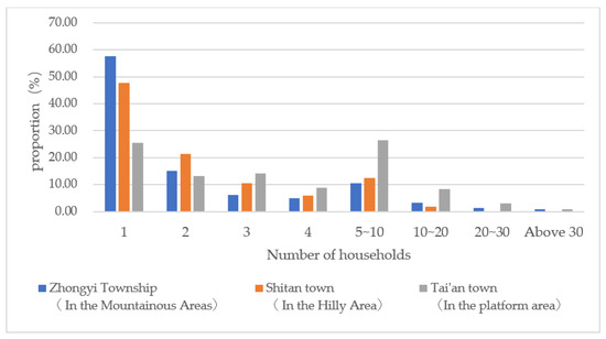
Figure 4.
The statistics of the homestead polygon number in different landforms.
3.4. The Landscape Index Distribution Features of Homesteads
Chongqing landform types are complex and diverse, and the spatial distribution of homesteads varies greatly. Because the homestead polygon is a landform polygon, the study uses the polygon density, distance index, and area index of landscape patterns and indices to analyze the distribution characteristics of the homestead (Table 5). The specific characteristics of the spatial distribution of different landform types of homesteads are as follows. First, the density of homesteads is the largest in the platform area, followed by the hill area and the mountainous area. The reason for this distribution is that the platform area has the largest number of homestead polygons per unit area, while the mountain area has less population and fewer homestead polygons. Second, the average distance between homesteads and homestead area per capita decreases gradually from the mountain-hill platform, indicating that the layout of mountain area homesteads is scattered and roughly utilized. Third, the distance index and area index increase from the mountain-hill platform, which indicates that homestead spatial agglomeration increases with decreasing elevation.
Table 5.
Spatial distribution and land use characteristics of homesteads with different landform types.
4. Homestead Agglomeration Mechanism in Different Landform Types
The above study indicates that there are significant differences in homestead agglomeration spatial features in different landform types. Therefore, the influencing factors are detected from three aspects: internal drive, external drive, and farmers’ subjective willingness. The influencing mechanism is analyzed. The internal driving factors include economic development, rural population movement, and homestead idleness, while the external driving factors include topographic conditions, location factors, and policy-driven factors. The subjective willingness of farmers is also analyzed. The mechanism of homestead spatial agglomeration in different landform types is analyzed from the above three aspects to provide empirical evidence for the spatial reconfiguration of rural settlements.
4.1. Homestead Agglomeration Driving Factor Identification in Different Landform Types
Geo Detector software was used for the geographical detection of driving factors of homestead agglomeration characteristics in different landform types. The results show that the characteristics of homestead spatial agglomeration in Chongqing are influenced by a combination of internal driving factors, external driving factors, and farmers’ willingness. However, the driving forces of homestead spatial agglomeration characteristics differed among landform types (Table 6). The factors with a larger influence in the platform area are mainly x12, x11, x18, x17, and x8. Hill area factors with stronger influence were x18, x10, x6, x15, and x2. The mountain area factors with high impact were x10, x11, x1, x5, and x3.
Table 6.
Geographical exploration results of driving factors of residential land agglomeration in different types of landforms.
4.2. Analysis of the Internal Mechanism of Homestead Agglomeration in Different Landform Types
4.2.1. Internal Driving Mechanism Analysis
In terms of socioeconomic development factors, market development, homestead idleness, and GDP per capita have the greatest impact in the platform area. The main reason is that the platform area has the advantages of flat terrain and convenient transportation. At the same time, due to favorable policies of “separation of powers” of agricultural land and homesteads, large-scale operations of agricultural land have been formed through land transfer, liberated rural labor, and freed farming households. In addition, these operations liberate the rural labor force. Farmers can choose to move to urban areas for employment and purchase houses, resulting in more homesteads being left idle and providing conditions for the withdrawal of homestead use rights or market access. Farmers can develop a collective economy by reclaiming or renting their homesteads to collective economic organizations, thus making the spatial layout of the homestead more concentrated. The ratio of outworkers and the rate of homestead idleness have a stronger influence on homestead agglomeration in mountain and hill areas. With the development of the social economy, the number of local migrant workers is increasing, and more farmers are choosing to buy houses in the city, which leads to the idleness of homesteads in remote areas. This directly affects the spatial agglomeration characteristics of the homestead.
4.2.2. External Driving Mechanism Analysis
In terms of terrain conditions, the natural environment varies among landform types. Differences in the degree of fragmentation of cultivated polygons lead to differences in the farming patterns of farmers. The mountainous and hilly areas are mainly dry land with small plots and relatively little land transfer. For the convenience of farming, homesteads are scattered in areas with high elevations and slopes. The platform area is flat and continuous due to the advantage of topographic conditions. The location of the homestead is mainly based on transportation conditions or kinship and is not constrained by topographic conditions. Hill area homestead agglomeration is strongly influenced by the average cultivation distance. Due to the fragmentation of the hill area land polygon and the limited conditions for large-scale land management, the area is still dominated by the farming family business method. Farmers have a high degree of dependence on the land and are not willing to relocate for a centralized living. The distance to the center of the county and the distance to the main roads are the most influential factors in the mountain area. It is not convenient for farmers in the mountain area to go out to work, shop, or send their children to school. Farmers who are able to do so will take the initiative to buy houses in areas with convenient transportation conditions, thus directly driving homestead agglomeration spatial pattern changes. In terms of policy, the implementation of the Chongqing land ticket policy integrates market mechanisms and government leadership. The land ticket production process integrates homestead reclamation into the integrated management of land consolidation, arable land occupation and replenishment, and ecological restoration. The land ticket production process integrates homestead reclamation into integrated management, such as land consolidation, arable land occupation and replenishment, and ecological restoration. Farmers voluntarily choose homestead reclamation to buy houses in the city, which directly affects the spatial layout structure of the homestead.
4.2.3. Analysis of Farmers’ Subjective Willingness
Farmers are the main subject of homestead utilization. The location and use of homesteads directly affect the characteristics of homestead spatial agglomeration. In the survey sample, 166 households were willing to agglomerate (47.7% of the total number of households surveyed), and 182 households were not willing to agglomerate (52.3% of the total number of households surveyed). There is no polarization of homestead agglomeration willingness among farmers in Chongqing. Homestead agglomeration can be driven by publicity, government subsidies, and house-for-house exchange. There are also differences in farmers’ homestead agglomeration willingness in different landscape areas. The ratio of farmers’ willingness to homestead agglomeration in the mountain area is 48.56%, the hill area ratio is 58.70%, and the platform area ratio is 62.5%. Survey respondents in the mountain area were older. The older the farmers in this area are, the fewer opportunities for nonfarm employment, the more dependent they are on their familiar environment, and the lower their willingness to live in a centralized manner. The selected hill area town is a typical agricultural town. Its agricultural industrialization and large-scale operation are still in the initial stage of development. The homestead agglomeration decision could be influenced by farmers’ age, the ratio of the number of family workers outside, and the behavioral decisions of neighbors.
5. Discussion
5.1. The Advantage of the Synergistic Perspective of Human and Natural Factors
With the development of social and economic transformation, the role of social, economic, cultural, and other human elements in shaping homestead space is becoming increasingly stronger. The interplay of human and natural elements is also becoming increasingly complex, and the intensity of the role of each element in homestead agglomeration varies greatly. First, taking the natural environmental factors as the entry point, this paper analyzes the spatial clustering characteristics of homesteads varying under different natural local conditions such as topography and landform. Thus, the analysis proves that the natural conditions have a direct influence on the spatial agglomeration of homesteads. In addition, the human factors are combined to establish the driving force system of homestead clustering in different geomorphological types. The researchers assisted the use of geographic probes as a device to identify the strength of their driving effects and analyzed the driving mechanisms from three aspects: intrinsic driving, external driving, and farmers’ subjective will. This paper avoids considering only the influence mechanism of spatial material form and natural elements and instead incorporates human and natural factors into a unified framework for analysis [53,54], delving into different landform type areas for comparative analysis, while fully considering the subjective will of farmers, to provide guidance for the optimal layout of homesteads in the future.
5.2. Extension of Research Results
The rural homestead in the hilly mountain area-hill of southwest China is still dominated by fragmentation. This is due to the moderate farming distance of the farmers. However, China is now comprehensively promoting the implementation of a land system reform and rural revitalization strategy, such as “three rights to separate” agricultural land and “three rights to separate” homestead. Therefore, as the income of farmers increases, more farmers are relocating on their own, and more administrative villages are planning centralized settlements for a better and more optimal layout of basic services. Thus, it can be seen that the moderate clustering of homesteads is the trend for the layout of rural homesteads in the future. Homestead spatial layout and reconstruction is a systemic project that requires, in parallel, systemic and holistic thinking, government intervention mechanisms, system synergy, and a commitment to build a platform for homestead agglomeration spatial optimization. The policy formulation should consider not only the socioeconomic and ecological benefits but also the living standards and happiness of the micro-subject farmers. At the same time, it is necessary to promote several reforms, such as a land system and household registration system to bring into play the comprehensive effect of the system reform.
5.3. Policy Suggestions for Future Homestead Agglomeration
Zhongyi town, Shitan town, and Tai’an town represent townships in the mountain, hill, and platform areas of Chongqing, respectively. Their development history, infrastructure conditions, and socioeconomic development levels differ significantly. The spatial agglomeration patterns of these rural settlements with different landform types vary greatly. This is not only related to the natural environment, such as topography and landscape, but to socioeconomic conditions, such as infrastructure, economic development, and policy initiatives as well; it is also directly related to the subjective will of farmers. Therefore, when optimizing and reconstructing rural settlements, it is necessary to develop regionally differentiated optimization paths according to local conditions. For the mountain area-hill in southwest China, farmers should be guided to locate homestead concentrations in areas with convenient transportation and production; the scattered homesteads guided by platform areas become relatively clustered. In addition, with respect for the local architectural and cultural characteristics and living habits of the residents, we propose planning and design requirements for homestead clustering in order to achieve the goal of improving the quality of the rural living environment and further promote the construction planning of “beautiful homes” in the mountain area-hill of southwest hills.
5.4. Limitations
In this paper, 17 driving factors were selected based on the data of 348 research questionnaires. The amount of data was limited and had a relatively simple set of driving factors. This may have led to a lack of robustness in the geographical detection results. Although the results of this study provide a reference for practical village planning, they cannot provide an implementable agglomeration planning scheme. To improve the practicality of moderate homestead agglomeration planning, more basic data and more detailed driving factors should be explored in the study area, and the spatial optimization scheme of homestead agglomeration should be developed scientifically by considering the field conditions and the practical needs of farmers comprehensively and carefully.
6. Conclusions
This study takes the representative townships of three major landform types in Chongqing as samples and analyses the homestead spatial agglomeration characteristics of different landform types in four aspects: terrain gradient, kernel density estimation, agglomeration characteristics, and landscape indices. The paper also investigates the driving factors and mechanisms from the internal driving factors, external driving factors, and the farmers’ willingness survey with 348 valid questionnaires from 22 villages. The main findings are as follows.
The distribution of the Chongqing homestead has obvious terrain gradient characteristics. With the increase in terrain gradients, such as elevation, slope, and terrain niche index, the overall trend of the homestead distribution index decreases. The distribution of homesteads is influenced by the topographic conditions. As the terrain gradient rises, the topography, climate, soil and water, and other natural geographic conditions gradually worsen, resulting in inconvenient transportation, poor infrastructure conditions, and limited industrial development which are not conducive to farming households living or engaging in various production activities. Farmers should be guided to live and work in areas suitable for moderate agglomeration.
The overall layout of the Chongqing homestead is mainly decentralized, but the degree of homestead agglomeration varies among different landform types, increasing in the mountain area-hill area-platform area agglomeration. Socioeconomic development is influenced by natural conditions to a certain extent. Homesteads in mountainous and hilly areas have a scattered spatial layout, poor infrastructure conditions, a high degree of idleness, and a traditional “masonry and wood” structure. Homesteads in platform areas have a relatively agglomerated spatial layout, excellent infrastructure conditions, reinforced concrete structures, and beautiful courtyards with greenery around the houses.
The homestead spatial agglomeration characteristics of rural settlements are driven by a combination of internal and external factors and farmers’ willingness; however, the driving factors of homestead agglomeration vary among landform types. There are differences in the driving factors of homestead agglomeration in different landform types. Mountainous and hilly areas of homestead agglomeration are driven by external factors such as elevation, slope, and location conditions. Internal driving factors such as the outworking ratio and homestead idleness rate are also important factors. Farmers’ willingness is another factor. These factors together influence the homestead agglomeration of the area. Platform area homestead agglomeration is driven by internal factors such as economic development, farmers’ livelihood patterns, and household income. Farmers’ willingness is, again, the other factor. Together, these factors influence homestead agglomeration in the area.
Author Contributions
The co-authors together contributed to the completion of this article. Their specific contributions follows: conceptualization, Y.Y. and Q.Y.; validation, Q.Y.; data curation, R.Z., H.Z. and X.Q.; formal analysis, Y.Y. and K.Y.; methodology, Y.Y., K.Y. and H.Z.; supervision, project administration, Q.Y.; writing—original draft, Y.Y.; writing—review and editing, Q.Y and Y.Y; visualization, Y.Y. All authors have read and agreed to the published version of the manuscript.
Funding
This research was funded by the National Natural Science Foundation of China, grant number 42071234 and by the special fund for basic scientific research business expenses of central colleges and universities, grant number swu2109308.
Institutional Review Board Statement
Not applicable.
Informed Consent Statement
Not applicable.
Data Availability Statement
Not applicable.
Conflicts of Interest
The authors declare no conflict of interest.
References
- Feng, Y.; Yang, Q. A review of research on the rural homestead evolution process and its regulation. Resour. Sci. 2015, 37, 442–448. [Google Scholar]
- Tu, S.; Zhou, X.; Long, H.; Liang, X. Research Progress and Prospect of Spatial Evolution and Optimization of Rural Settlements. Econnmic Geogr. 2019, 39, 142–149. [Google Scholar]
- Ji, Z.; Xu, Y.; Lu, L.; Duan, Y.; Li, Y.; Huang, A. Research Progress and Prospects for Spatial Optimization of Rural Settlements. China Land Sci. 2021, 35, 95–104. [Google Scholar]
- Chen, Z.; Liu, Y.; Feng, W.; Li, Y.; Li, L. Study on spatial tropism distribution of rural settlements in the Loess Hilly and Gully Region based on natural factors and traffic accessibility. J. Rural. Stud. 2019, 93, 441–448. [Google Scholar] [CrossRef]
- Ruan, R. Occurrence Mechanism, Developing Stage and Compensation for Removing in the Progress of Centralizing Inhabitation in Rural China: A Case Study on Xinqiao Town. China Popul. Resour. Environ. 2012, 22, 112–118. [Google Scholar]
- Yang, Q.; Tian, Y.; Wang, C.; Zhou, T.; Liu, X. On the land use characteristics and the land consolidation models of rural residential area of the hilly and mountainous regions in Southwest China: A case of Chongqing. Geogr. Res. 2004, 23, 469–478. [Google Scholar]
- Wang, Z.; Zhu, W.; Yang, Q. Research Review and Prospects for Village Consolidation in China in the Past 30 Years. China Land Sci. 2021, 35, 107–116. [Google Scholar]
- Dong, Z. “Separation of three rights”—A major innovation in the rural homestead system. Chin. Land 2018, 3, 4–9. [Google Scholar]
- Long, H.; Ge, D.; Wang, J. Progress and prospects of the coupling research on land use transitions and rural transformation development. Acta Geogr. Sin. 2019, 74, 2547–2559. [Google Scholar]
- Rigg, J.; Veeravongs, S.; Veeravongs, L.; Rohitarachoon, P. Reconfiguring rural spaces and remaking rural lives in central Thailand. J. Southeast Asian Stud. 2008, 39, 355–381. [Google Scholar] [CrossRef]
- Jesus Rivera, M. NEO-RURALITY AND ITS MEANINGS The case of Navarre. Rev. Int. De Sociol. 2009, 67, 413–433. [Google Scholar]
- Yeo, H.S.; Dong, S.S.; Suh, J.H. A Study about the Improving Rural Landscape’s Envrionmental color-Focusing on the Gyeongju villages around the Roof Color. J. Korea Des. Knowl. 2010, 16, 63–71. [Google Scholar]
- Park, K.; Kim, T.-I. A study on the Architectural planning of Farmhouse Types -Focused on Residential and Storage space planning in Farmhouse to Farming Scale. J. Korean Inst. Rural. Archit. 2014, 16, 53–60. [Google Scholar] [CrossRef]
- Zhuo, R.; Rosenberg, M.; Yu, B.; Guo, X.; Wang, M. Accessibility of Rural Life Space on the Jianghan Plain, China: The Role of Livelihood. Int. J. Environ. Res. Public Health 2021, 18, 1301. [Google Scholar] [CrossRef]
- Garland, J.; Chakraborti, N. ‘Race’, space and place-Examining identity and cultures of exclusion in rural England. Ethnicities 2006, 6, 159–177. [Google Scholar] [CrossRef] [Green Version]
- Walsh, K.; O’Shea, E.; Scharf, T. Rural old-age social exclusion: A conceptual framework on mediators of exclusion across the lifecourse. Ageing Soc. 2020, 40, 2311–2337. [Google Scholar] [CrossRef] [Green Version]
- Muemken, S.A.; Gellert, P.; Stollwerck, M.; O’Sullivan, J.L.; Kiselev, J. Validation of the German Life-Space Assessment (LSA-D): Cross-sectional validation study in urban and rural community-dwelling older adults. Bmj Open 2021, 11, e049926. [Google Scholar] [CrossRef]
- Berg, N.G. Geographies of wellbeing and place attachment: Revisiting urban-rural migrants. J. Rural. Stud. 2020, 78, 438–446. [Google Scholar] [CrossRef]
- Liu, C.-M.; Shang, Z.-Y.; Zhou, H.-Y.; Wang, C.-X.; CAI, A.-N. Villagers’ living space characteristics and their willingness to relocation in plain farming area: A case study of Huai’an. J. Nat. Resour. 2020, 35, 2014–2028. [Google Scholar]
- Lu, X. Dispersed and Clustered: Rural Settlement Patterns and Its Evolution in Traditionl China. J. Huazhong Norm. Univ. 2013, 52, 113–130. [Google Scholar]
- Zhang, X. On discrimination of rural definitions. Acta Geogr. Sin. 1998, 53, 79–85. [Google Scholar]
- Hu, X.; Li, H.; Zhang, X.; Yuan, Y. On the re-cognition of rural definitions. Acta Geogr. Sin. 2020, 75, 398–409. [Google Scholar]
- Jia, K.; Qiao, W.; Chai, Y.; Feng, T.; Wang, Y.; Ge, D. Spatial distribution characteristics of rural settlements under diversified rural production functions: A case of Taizhou, China. Habitat Int. 2020, 102, 102201. [Google Scholar] [CrossRef]
- Yin, J.; Li, H.; Wang, D.; Liu, S. Optimization of Rural Settlement Distributions Based On the Ecological Security Pattern: A Case Study of Da’an City in Jilin Province of China. Chin. Geogr. Sci. 2020, 30, 824–838. [Google Scholar] [CrossRef]
- Long, H.; Tu, S. Rural restructuring: Theory, approach and research prospect. Acta Geogr. Sin. 2017, 72, 563–576. [Google Scholar]
- Long, H.; Tu, S. Theoretical thinking of rural restructuring. Prog. Geogr. 2018, 37, 581–590. [Google Scholar]
- You, L.; Chen, C. Planning and Implementing Smart Shrinkage of Rural China: The Case of Chengdu’s Rural Settlement Consolidation with SGME Model. J. Reg. City Plan. 2019, 30, 62–75. [Google Scholar] [CrossRef]
- Qu, Y. Transition of rural settlements: Concept, feature, mechanism and path. Sci. Geogr. Sin. 2020, 40, 572–580. [Google Scholar]
- Chen, C.; Gao, J.; Chen, J. Institutional changes, land use dynamics, and the transition of rural settlements in suburban China: A case study of Huishan District in Wuxi city. Habitat Int. 2017, 70, 24–33. [Google Scholar] [CrossRef]
- Yang, Q.; Zhang, R.; Su, K.; Zhang, H.; Wang, W.; Zhang, H. A study of rural construction based on Bayu Homestay. J. Southwest Univ. 2021, 43, 1–10. [Google Scholar]
- Qu, Y.; Jiang, G.; Ma, W.; Li, Z. How does the rural settlement transition contribute to shaping sustainable rural development? Evidence from Shandong, China. J. Rural. Stud. 2021, 82, 279–293. [Google Scholar]
- Wang, C.; Huang, B.; Deng, C.; Wan, Q.; Zhang, L.; Fei, Z.; Li, H. Rural settlement restructuring based on analysis of the peasant household symbiotic system at village level: A Case Study of Fengsi Village in Chongqing, China. J. Rural. Stud. 2016, 47, 485–495. [Google Scholar] [CrossRef]
- Long, H. Land consolidation: An indispensable way of spatial restructuring in rural China. J. Geogr. Sci. 2014, 24, 211–225. [Google Scholar] [CrossRef]
- Jin, Q. The scale and layout of rural settlements in Jiangsu Province. J. Archit. 1983, (10), 55–56. [Google Scholar]
- Kuang, Y.; Yang, Q.; Wang, Z.; Mu, W.; Bi, G. Optimization of Residential Settlement Layout in Urban Fringe in Hilly Region: A Case Study of Gulu Town, Chongqing, China. Mt. Ain Res. 2017, 35, 399–411. [Google Scholar]
- Feng, Y.; Long, H. Progress and prospect of research on spatial reconstruction of rural settlements in mountainous areas of China. Prog. Geogr. 2020, 39, 866–879. [Google Scholar] [CrossRef]
- Yang, R.; Liu, Y.; Long, H.; Wang, Y.; Zhang, Y. Spatial Distribution Characteristics and Optimized Reconstructing Analysis of Rural Settlement in China. Sci. Geogr. Sin. 2016, 36, 170–179. [Google Scholar]
- Zhang, X.; Pan, M. Emerging rural spatial restructuring regimes in China: A tale of three transitional villages in the urban fringe. J. Rural. Stud. 2022, 93, 287–300. [Google Scholar] [CrossRef]
- Zhu, X.; Zhu, J.; Qiao, J. Research progress and prospect on Chinese rural settlements. Hum. Geogr. 2016, 31, 33–41. [Google Scholar]
- Li, H. Rural settlements research from the perspective of resilience theory. Sci. Geogr. Sin. 2020, 40, 556–562. [Google Scholar]
- Zhou, H.; Ning, X.; Na, X.; Zhang, X.; Li, W. Spatial distribution variation of rural settlements in Damao Banner of Baotou City and its impact factors. Trans. Chin. Soc. Agric. Eng. 2019, 35, 276–286. [Google Scholar]
- Su, K.; Hu, B.; Shi, K.; Zhang, Z.; Yang, Q. The structural and functional evolution of rural homesteads in mountainous areas: A case study of Sujiaying village in Yunnan province, China. Land Use Policy 2019, 88, 104100. [Google Scholar] [CrossRef]
- Zhang, B.; Qian, J.; Cai, W. Discussion on mixed use of rural residential land research framework. J. Nat. Resour. 2020, 35, 2929–2941. [Google Scholar] [CrossRef]
- Zhang, Z.; Wen, Y.; Wang, R.; Han, W. Factors influencing rural households’ willingness of centralized residence: Comparing pure and nonpure farming areas in China. Habitat Int. 2018, 73, 25–33. [Google Scholar] [CrossRef]
- Lou, T.; Wang, W.; Lu, Y.; Xiao, J.; Xiao, X. An improved consumer decision model for rural residential development: A theoretical framework and empirical evidence from China. Habitat Int. 2020, 105, 102266. [Google Scholar] [CrossRef]
- Yan, Y.; Yang, Q.; Su, K.; Bi, G.; Li, Y. Farmers’ Willingness to gather homesteads and the influencing factors-An empirical study of different geomorphic Areas in Chongqing. Int. J. Environ. Res. Public Health 2022, 19, 5252. [Google Scholar] [CrossRef]
- Li, Y.; Qiao, L.; Wang, Q.; Dávid, K. Towards the evaluation of rural livability in China: Theoretical framework and empirical case study. Habitat Int. 2020, 105, 102241. [Google Scholar]
- Liu, W.; Spaargaren, G.; Mol, A.P.J.; Heerink, N.; Wang, C. Low carbon rural housing provision in China: Participation and decision making. J. Rural. Stud. 2014, 35, 80–90. [Google Scholar] [CrossRef]
- Yang, B.; Wang, Z.; Zhang, H.; Tan, L. Spatial pattern evolution characteristics and driving mechanism of rural settlements in high mountain areas with poverty. Trans. Chin. Soc. Agric. Eng. 2021, 37, 285–293. [Google Scholar]
- Wang, G.; Li, S.; Ma, Q. Spatial equilibrium and pattern evolution of ecological civilization construction efficiency in China. Acta Geogr. Sin. 2018, 73, 2198–2209. [Google Scholar]
- Zheng, X.; Zheng, H.w.; Zhao, L.Y. Spatial Distribution and Influencing Factors of Rural Residential Areas Based on GIS: A Case Study of Xuyi County. Chin. J. Soil Sci. 2019, 50, 550–554. [Google Scholar]
- Wang, J.; Xu, C. Geodetector: Principle and prospective. Acta Geogr. Sin. 2017, 72, 116–134. [Google Scholar]
- Yang, R.; Xu, Q.; Long, H. Spatial distribution characteristics and optimized reconstruction analysis of China’s rural settlements during the process of rapid urbanization. J. Rural. Stud. 2016, 47, 413–424. [Google Scholar] [CrossRef]
- Hu, X.; Li, H.; Zhang, X.; Chen, X.; Yuan, Y. Multi-dimensionality and the totality of rural spatial restructuring from the perspective of the rural space system: A case study of traditional villages in the ancient Huizhou region, China. Habitat Int. 2019, 94, 102062. [Google Scholar] [CrossRef]
Publisher’s Note: MDPI stays neutral with regard to jurisdictional claims in published maps and institutional affiliations. |
© 2022 by the authors. Licensee MDPI, Basel, Switzerland. This article is an open access article distributed under the terms and conditions of the Creative Commons Attribution (CC BY) license (https://creativecommons.org/licenses/by/4.0/).