
Past Human Mobility Corridors and Least-Cost Path Models South of General Carrera Lake, Central West Patagonia (46° S, South America)


Abstract
:1. Introduction
2. Materials and Methods
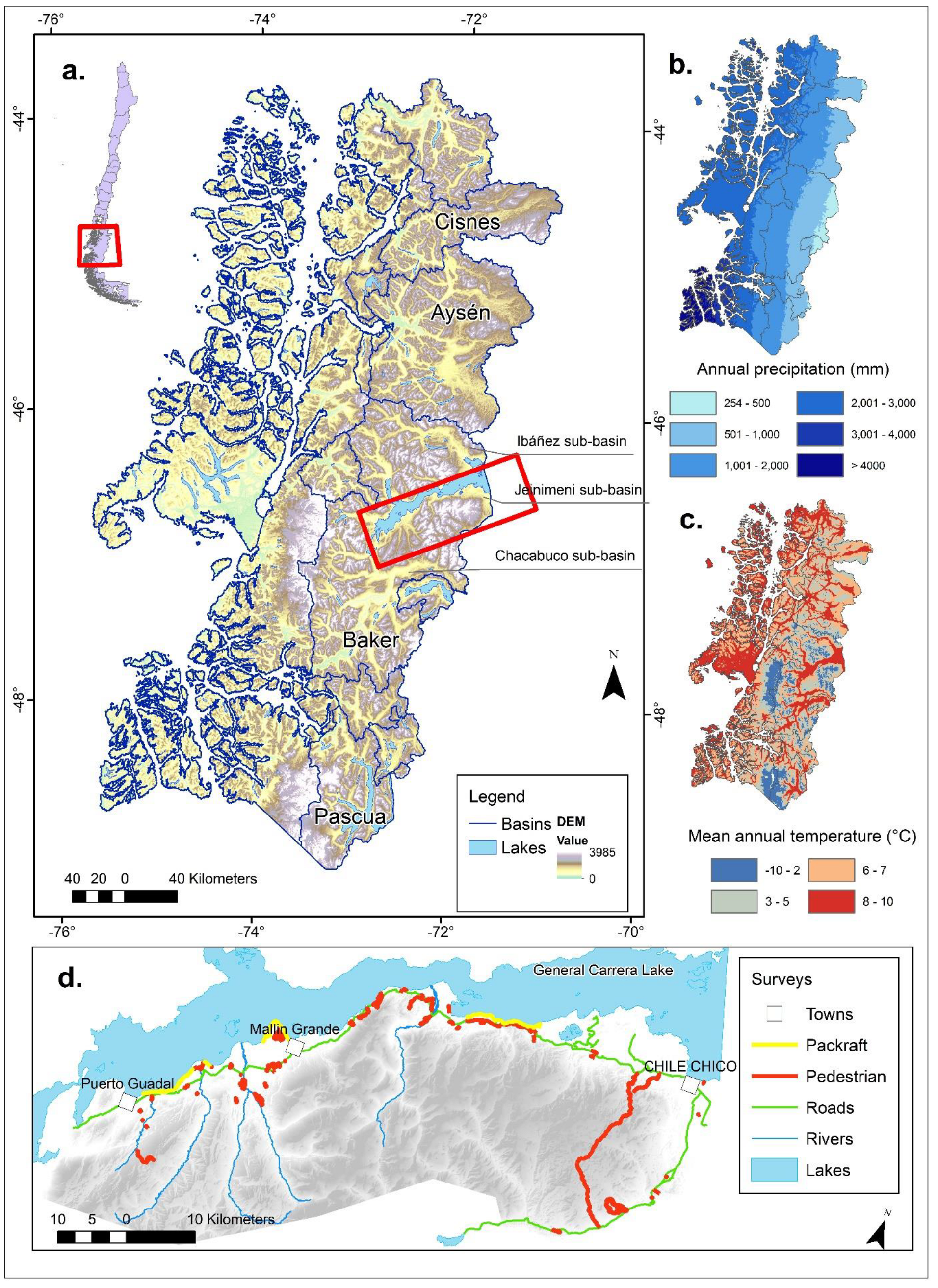
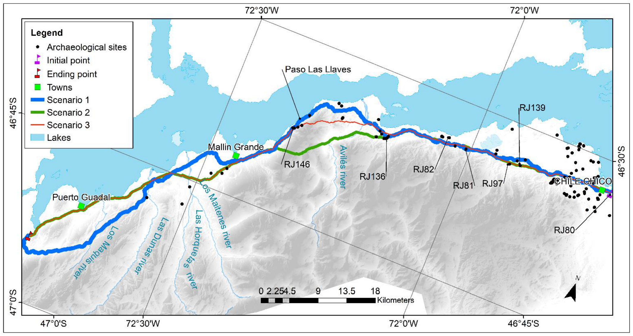
2.1. Study Area
2.2. Archaeological Material and Methods
2.3. Least-Cost Path Model
2.3.1. Cost Surface Scenarios
- Scenario 1 (control) uses slope as the only criteria to build the cost surface and for deciding a possible path. Scenario 1 is conceptualized as the standard scenario.
- Scenario 2 (summer) represents the summer season, and the cost surface is defined by a combination of slope (70%) and land use (30%).
- Scenario 3 (winter) represents a model of the winter season mobility corridor by incorporating snow coverage as an additional restriction for human movement.
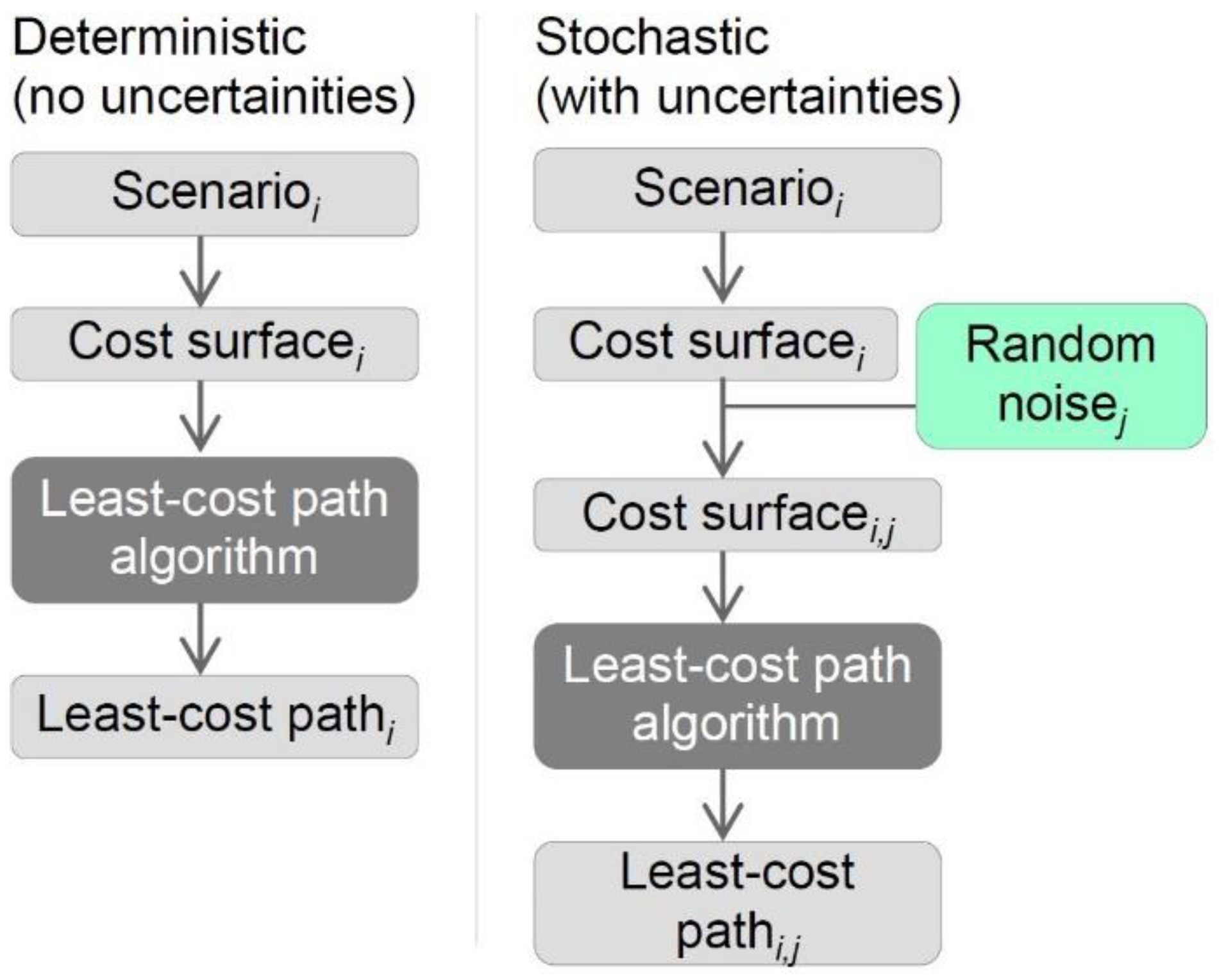
2.3.2. Deterministic Least-Cost Paths
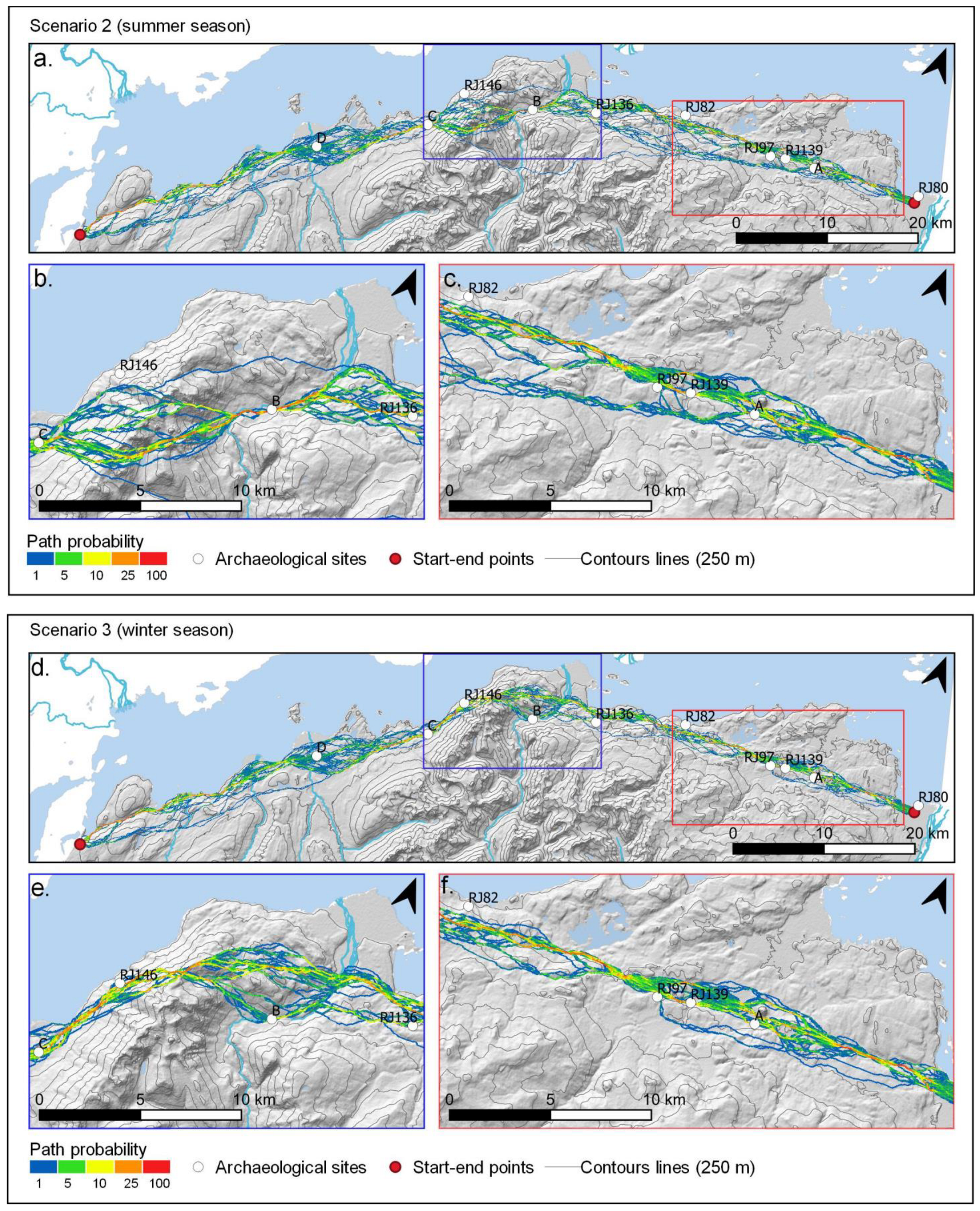
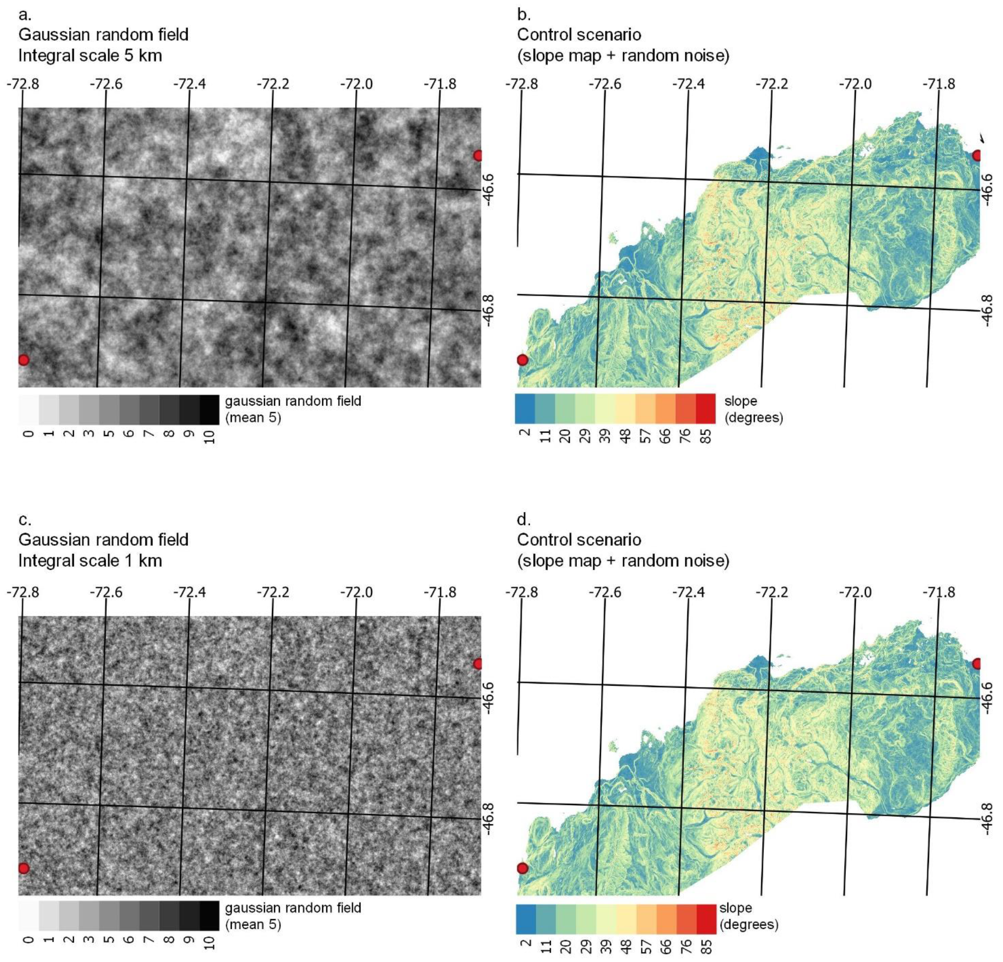
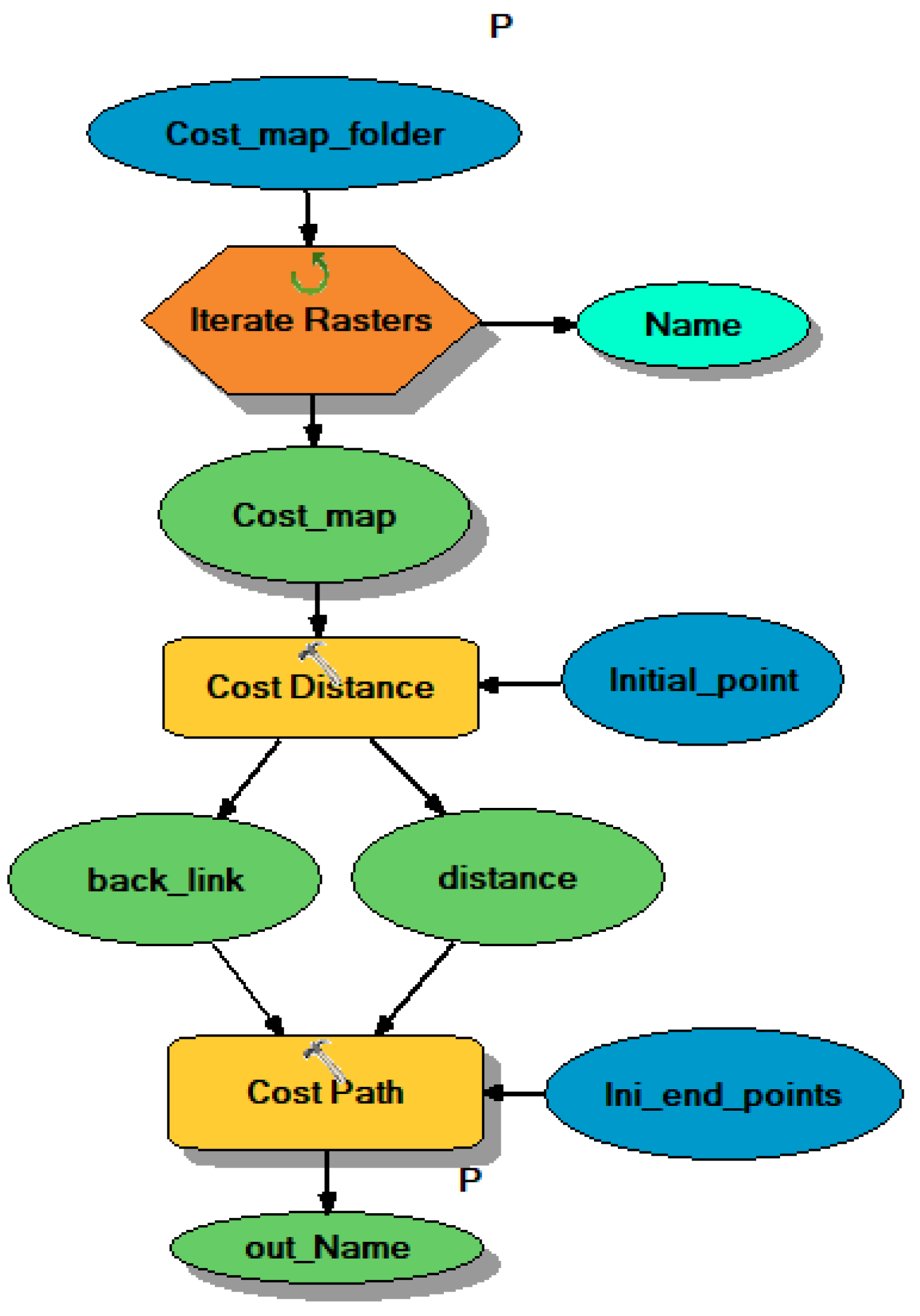
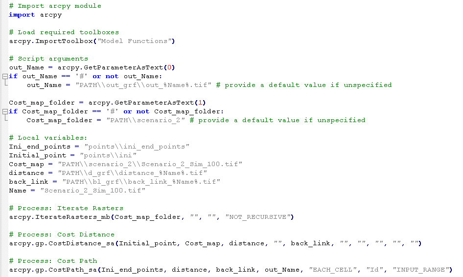
2.3.3. Stochastic Least-Cost Paths
- Deterministic (without uncertainties). LCPs were obtained for Scenarios 1, 2, and 3 without adding uncertainties, and the output corresponds to one LCP for each scenario (i ∈ (1, 2, 3) in Figure 2).
- Stochastic (with uncertainties or variability). The LCPs were obtained for Scenario 2 and Scenario 3 (i ∈ (1, 2) in Figure 2). For each scenario, we performed one hundred simulations (j ∈ (1, 2, …, 100) in Figure 2), where for each simulation, a different j random noise was added to the i cost surface. Then, the output or mobility corridor corresponds to an ensemble of a hundred likely routes.
2.4. Validation of Deterministic Least-Cost Paths
3. Results
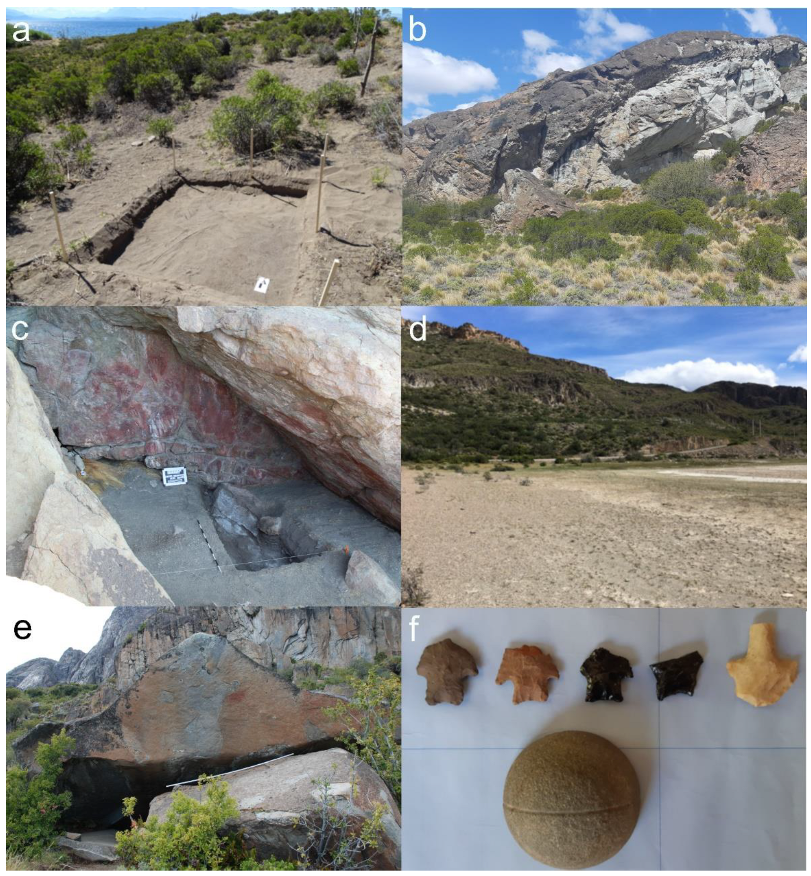
3.1. The Archaeological Record of the Southern Coast of General Carrera Lake
3.1.1. Site Distribution and Characteristics
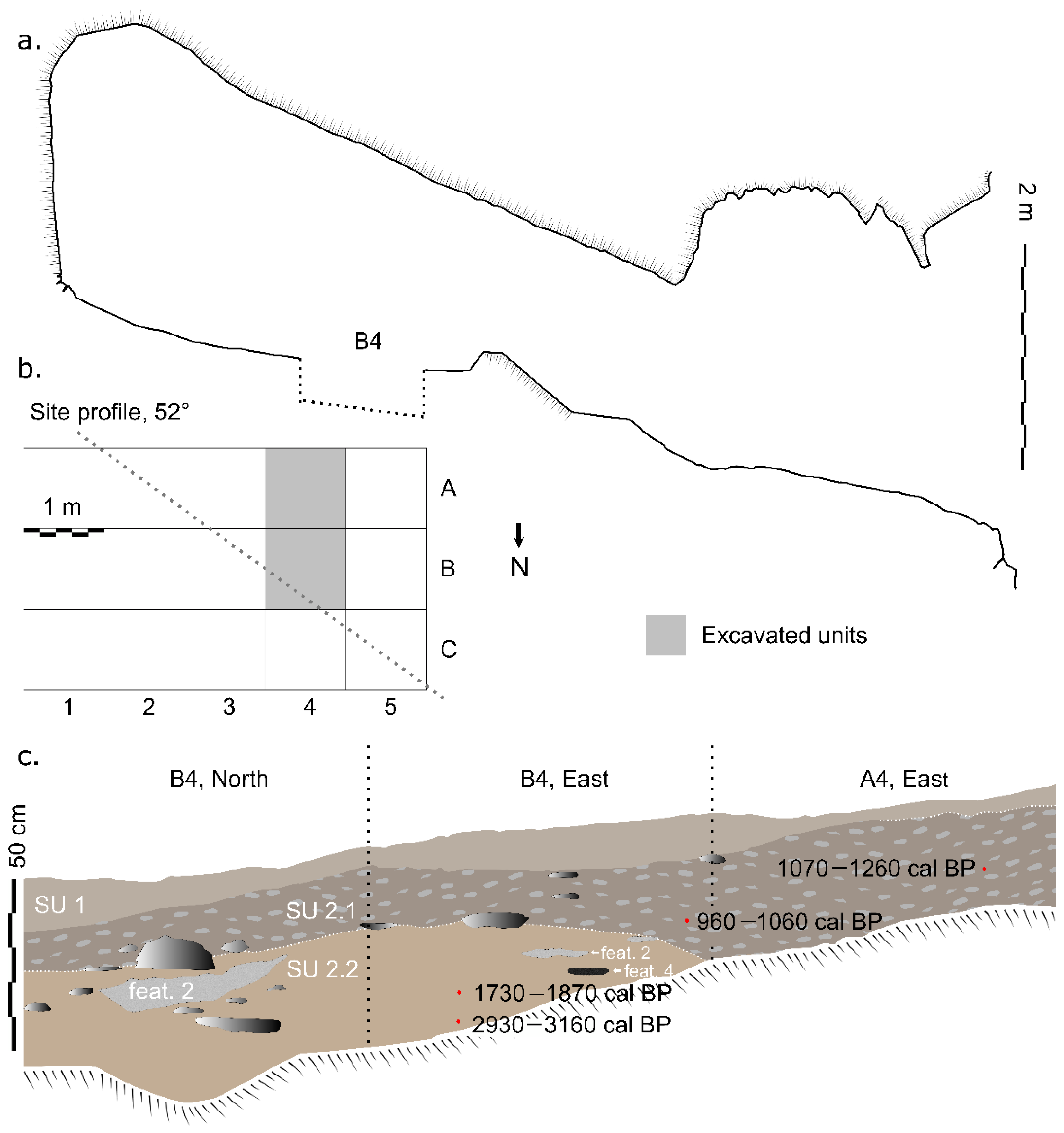
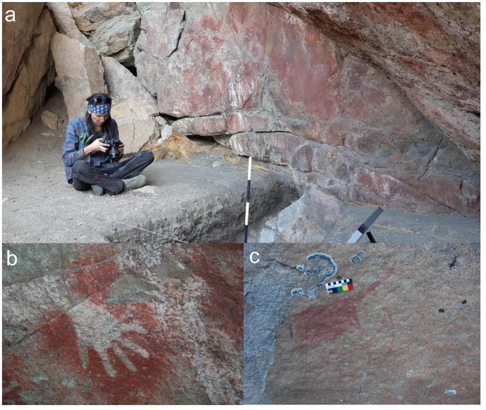
3.1.2. La Tina Site Context and Chronology
3.2. Least-Cost Path Models
3.2.1. Deterministic Least-Cost Paths
3.2.2. Stochastic Least-Cost Paths for Summer and Winter Scenarios
4. Discussion
4.1. The Occupation of the Southern Coast of General Carrera Lake
4.2. Least-Cost Paths and Uncertainties
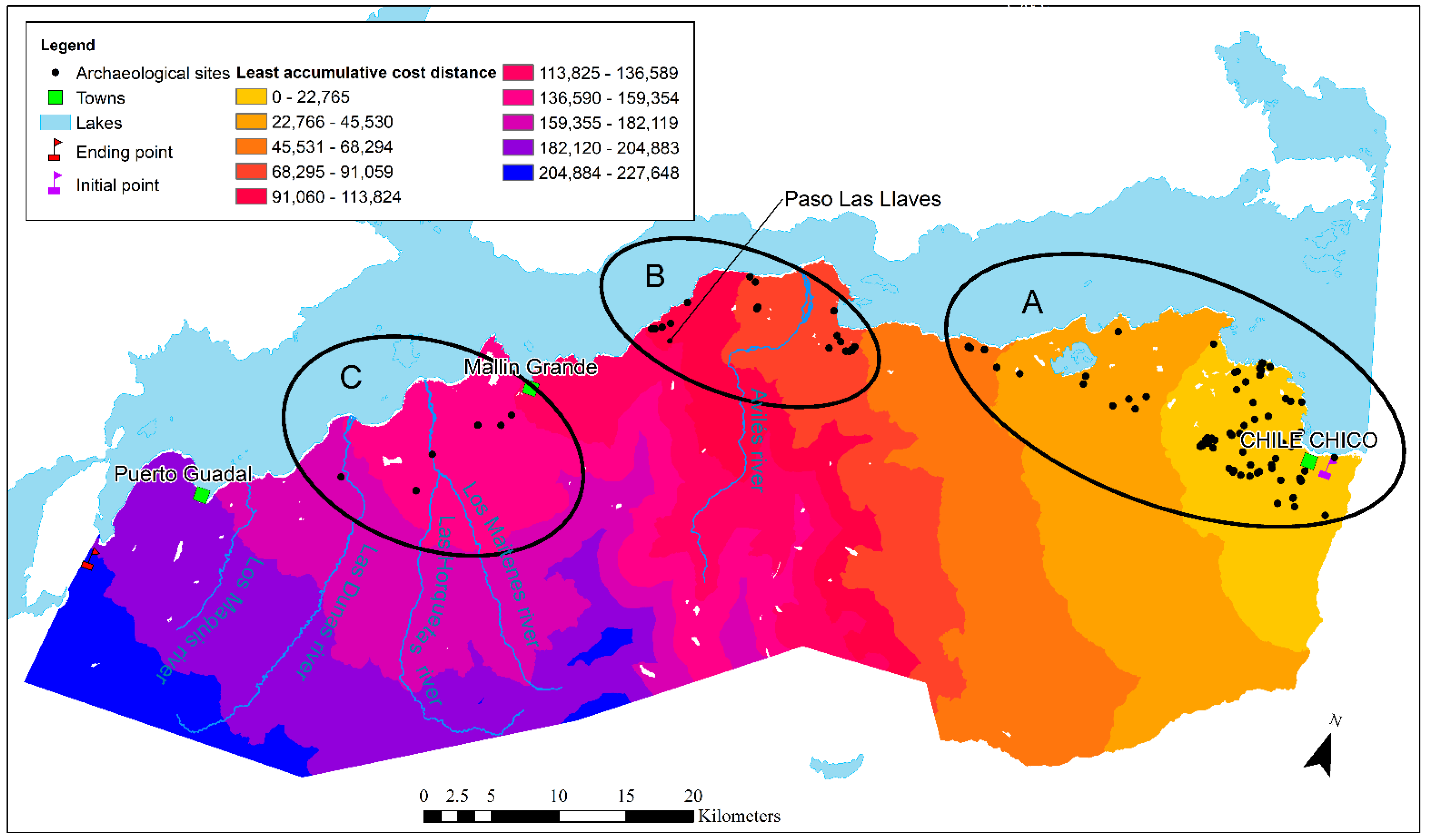
4.3. Cluster and the Least Accumulative Cost Distance
4.4. Critical Zones for Movement along the Southern Coast of General Carrera Lake
5. Conclusions
Supplementary Materials
Author Contributions
Funding
Data Availability Statement
Acknowledgments
Conflicts of Interest
Appendix A. Least-Cost Path Model Sensitivity Analysis


References
- Borrero, L.A. The archaeozoology of the Andean ‘dead ends’ in Patagonia: Living near the continental ice cap. In Colonisation, Migration, and Marginal Areas: A Zooarchaeological Approach; Mondini, M., Muñoz, S., Wickler, S., Eds.; Oxbow Books: Havertown, PA, USA, 2004; pp. 55–61. [Google Scholar]
- Pallo, M.C.; Borrero, L.A. Arqueología de corredores boscosos en Patagonia meridional: El caso del río Guillermo (SO de la provincia de Santa Cruz, Argentina). Intersecc. Antropol. 2015, 16, 313–326. [Google Scholar]
- Méndez, C.; Reyes, O. Late Holocene human occupation of the Patagonian forests: A case study in the Cisnes river basin. Antiquity 2008, 82, 560–570. [Google Scholar] [CrossRef]
- Gamble, C. The Palaeolithic Societies of Europe; Cambridge University Press: Cambridge, UK, 1999. [Google Scholar]
- Rockman, M. Landscape learning in relation to evolutionary theory. In Macroevolution in Human Prehistory: Evolutionary Theory and Processual Archaeology; Prentiss, A., Kuijt, I., Chatters, J.C., Eds.; Springer: New York, NY, USA, 2009; pp. 51–71. [Google Scholar]
- Lovis, W.A.; Donahue, R.E. Space, information, and knowledge: Ethnocartography and North American boreal forest hunter-gatherers. In Information and Its Role in Hunter-Gatherer Bands; Whallon, R., Lovis, W.A., Hitchcock, R.K., Eds.; Cotsen Institute of Archaeology Press: Los Angeles, CA, USA, 2011; pp. 59–84. [Google Scholar]
- Nielsen, A.E.; Berenguer, J.; Pimentel, G. Inter-nodal archaeology, mobility, and circulation in the Andes of Capricorn during the late intermediate period (AD 1000–1450). Quat. Int. 2019, 533, 48–65. [Google Scholar] [CrossRef]
- Barberena, R.; Villanueva, G.R.; Lucero, G.; Fernández, M.V.; Rughini, A.A.; Sosa, P. Espacios internodales en Patagonia septentrional: Biogeografía, información y mecanismos sociales de interacción. Estud. Atacameños 2017, 56, 57–75. [Google Scholar] [CrossRef]
- Scheinsohn, V. Rock art information among hunter-gatherers in northwest Patagonia: An assessment of broad-scale and territorial models. In Information and Its Role in Hunter-Gatherer Bands; Whallon, R., Lovis, W.A., Hitchcock, R.K., Eds.; Cotsen Institute of Archaeology Press: Los Angeles, CA, USA, 2011; pp. 235–247. [Google Scholar]
- Gowen, K.M.; de Smet, T.S. Testing least cost path (LCP) models for travel time and kilocalorie expenditure: Implications for landscape genomics. PLoS ONE 2020, 15, e0239387. [Google Scholar] [CrossRef]
- White, D.A.; Surface-Evans, S.L. Least Cost Analysis of Social Landscapes: Archaeological Case Studies; University of Utah Press: Salt Lake City, UT, USA, 2012. [Google Scholar]
- Herzog, I. Least-cost paths—Some methodological issues. Internet Archaeol. 2014, 36. [Google Scholar] [CrossRef]
- Herzog, I. Issues in replication and stability of least-cost path calculations. Stud. Digit. Herit. 2022, 5, 131–155. [Google Scholar] [CrossRef]
- Bell, T.; Wilson, A.; Wickham, A. Tracking the Samnites: Landscape and Communications Routes in the Sangro Valley, Italy. Am. J. Archaeol. 2002, 106, 169–186. [Google Scholar] [CrossRef]
- Rademaker, K.; Reid, D.A.; Bromley, G.R.M. Connecting the dots: Least-cost analysis, paleogeography, and the search for Paleoindian sites in southern highland Peru. In Least Cost Analysis of Social Landscapes: Archaeological Case Studies; White, D.A., Surface-Evans, S., Eds.; University of Utah Press: Salt Lake City, UT, USA, 2012; pp. 32–45. [Google Scholar]
- White, D.A. The basics of least cost analysis for archaeological applications. Adv. Archaeol. Pract. 2015, 3, 407–414. [Google Scholar] [CrossRef]
- Jarvis, A.; Reuter, H.I.; Nelson, A.; Guevara, E. Hole-Filled Seamless SRTM for the Globe Version 4. Available from the CGIAR-CSI SRTM 90 m Database. Available online: https://srtm.csi.cgiar.org (accessed on 4 October 2017).
- Logan, T.A.; Nicoll, J.; Laurencelle, J.; Hogenson, K.; Gens, R.; Buechler, B.; Barton, B.; Shreve, W.; Stern, T.; Drew, L.; et al. Radiometrically terrain corrected ALOS PALSAR data available from the Alaska satellite facility. In American Geophysical Union, Fall Meeting 2014; American Geophysical Union: Washington, DC, USA, 2014. [Google Scholar]
- Lewis, J. Probabilistic modelling for incorporating uncertainty in least cost path results: A postdictive Roman road case study. J. Archaeol. Method Theory 2021, 28, 911–924. [Google Scholar] [CrossRef]
- Howey, M.C.L. Multiple pathways across past landscapes: Circuit theory as a complementary geospatial method to least cost path for modeling past movement. J. Archaeol. Sci. 2011, 38, 2523–2535. [Google Scholar] [CrossRef]
- McLean, A.; Rubio-Campillo, X. Beyond least cost paths: Circuit theory, maritime mobility and patterns of urbanism in the Roman Adriatic. J. Archaeol. Sci. 2022, 138, 105534. [Google Scholar] [CrossRef]
- Franco, N.V.; Borrero, L.A.; Lucero, G.F. Human dispersal in the Atlantic slope of Patagonia and the role of lithic availability. PaleoAmerica 2019, 5, 88–104. [Google Scholar] [CrossRef]
- Pallo, M.C.; Borrero, L.A. Análisis multicriterio sobre barreras biogeográficas para la movilidad humana en Patagonia meridional. Estud. Atacameños 2020, 64, 277–295. [Google Scholar] [CrossRef]
- Borrero, L.A.; Nuevo-Delaunay, A.; Méndez, C. Ethnographical and historical accounts for understanding the exploration of new lands: The case of Central Western Patagonia, southernmost South America. J. Anthropol. Archaeol. 2019, 54, 1–16. [Google Scholar] [CrossRef]
- Méndez, C.; Nuevo-Delaunay, A.; Reyes, O.; Ozán, I.L.; Belmar, C.; López, P. The initial peopling of Central Western Patagonia (southernmost South America): Late Pleistocene through Holocene site context and archaeological assemblages from Cueva de la Vieja site. Quat. Int. 2018, 473, 261–277. [Google Scholar] [CrossRef]
- Nuevo-Delaunay, A.; Méndez, C.; Reyes, O.; Carranza, J. Cazadores recolectores y vías de circulación al este del Campo de Hielo Norte. Biodiversidata 2019, 8, 138–140. [Google Scholar]
- Nuevo-Delaunay, A.; Méndez, C.; Reyes, O.; Seelenfreund, A.; Belmar, C. La ocupación humana antigua de los callejones sin salida de los Andes de Patagonia: Midiendo la intensidad de uso del espacio en los márgenes del Campo de Hielo Norte (Aisén, Chile). Chungara Rev. Antropol. Chil. 2022. [Google Scholar] [CrossRef]
- García, C.; Mena, F. ¿La frontera del oeste? Prospecciones arqueológicas en el bosque montano del extremo occidental del valle medio del río Ibáñez (Andes patagónicos, Chile). Intersecc. Antropol. 2016, 17, 49–61. [Google Scholar]
- Mena, F.; Blanco, J. Estado de la investigación arqueológica del valle del Chacabuco, Andes Centro Patagónicos. XI region de Aisén, Chile. Magallania 2017, 45, 199–217. [Google Scholar] [CrossRef]
- Martinic, M. Los Aónikenk; Ediciones de la Universidad de Magallanes: Punta Arenas, Chile, 1995. [Google Scholar]
- Musters, G.C. At Home with the Patagonians. A Year’s Wanderings over Untrodden Ground From the Straits of Magellan to the Río Negro; John Murray: London, UK, 1871. [Google Scholar]
- Aguerre, A.M. Las Vidas de Pati en la Toldería Tehuelche del Río Pinturas y el Después; Universidad de Buenos Aires: Buenos Aires, Chile, 2000. [Google Scholar]
- Nuevo Delaunay, A. Disarticulation of Aónikenk hunter-gatherer lifeways during the late nineteenth and early twentieth centuries: Two case studies from Argentinean Patagonia. Hist. Archaeol. 2012, 46, 149–164. [Google Scholar] [CrossRef]
- Nuevo Delaunay, A.; Belardi, J.B.; Carballo Marina, F.; Saletta, M.J.; De Angelis, H. Glass and stoneware knapped tools among hunter-gatherers in southern Patagonia and Tierra del Fuego. Antiquity 2017, 91, 1330–1343. [Google Scholar] [CrossRef]
- Borrero, L.A.; Borrazzo, K. Geografía cultural del sudoeste de Patagonia continental. In Bosques, Montañas y Cazadores. Investigaciones Arqueológicas en Patagonia Meridional; Borrero, L.A., Borrazzo, K., Eds.; IMHICIHU: Buenos Aires, Chile, 2011; pp. 7–36. [Google Scholar]
- Steffen, H. Patagonia Occidental. Las Cordilleras Patagónicas y sus Regiones Circundantes Vol. II; La Silla Editores: Santiago, Chile, 2009. [Google Scholar]
- Martinic, M. De la Trapananda al Áysen; Pehuén Editores: Santiago, Chile, 2005. [Google Scholar]
- Belmar, C.; Méndez, C.; Reyes, O. Hunter-gatherer plant resource use during the Holocene in central western Patagonia (Aisén, Chile, South America). Veget. Hist. Archaeobot. 2017, 26, 607–625. [Google Scholar] [CrossRef]
- Garreaud, R.D. The Andes climate and weather. Adv. Geosci. 2009, 22, 3–11. [Google Scholar] [CrossRef]
- Romero, H. Geografía de los Climas. Geografía de Chile; Instituto Geográfico Militar: Santiago, Chile, 1985. [Google Scholar]
- Luebert, F.; Pliscoff, P. Sinopsis Bioclimática y Vegetacional de Chile; Editorial Universitaria: Santiago, Chile, 2006. [Google Scholar]
- Silva, F.; Ahumada, M.; Cerda, J. Guias de Condición Para los Pastizales de la Ecorregión Templada Intermedia de Aysén; Servicio Agrícola y Ganadero; Ministerio de Agricultura: Coyhaique, Chile, 1999.
- Maldonado, A.; de Porras, M.E.; Martel-Cea, A.; Reyes, O.; Nuevo-Delaunay, A.; Méndez, C. Holocene environmental dynamics of the lago Cochrane/Pueyrredón valley, Central West Patagonia (47° S). Front. Earth Sci. 2022, 10, 833637. [Google Scholar] [CrossRef]
- de Porras, M.E.; Maldonado, A.; Abarzúa, A.M.; Cardenas, M.L.; Francois, J.P.; Martel-Cea, A.; Stern, C.R.; Méndez, C.; Reyes, O. Postglacial vegetation, fire and climate dynamics at Central Chilean Patagonia (lake Shaman, 44° S). Quat. Sci. Rev. 2012, 50, 71–85. [Google Scholar] [CrossRef]
- de Porras, M.E.; Maldonado, A.; Quintana, F.A.; Martel-Cea, A.; Reyes, O.; Méndez, C. Environmental and climatic changes in Central Chilean Patagonia since the late Glacial (Mallin El Embudo, 44° S). Clim. Past 2014, 10, 1063–1078. [Google Scholar] [CrossRef]
- McCulloch, R.D.; Figuerero Torres, M.J.; Mengoni Goñalons, G.L.; Barclay, R.; Mansilla, C. A Holocene record of environmental change from Río Zeballos, Central Patagonia. Holocene 2017, 27, 941–950. [Google Scholar] [CrossRef]
- Quemada, C. Estudio Comparativo del Uso del Espacio de Cuatro Valles en la Región de Aisén Oriental: Valle del Río Cisnes, Valle del Río Ibáñez, Valle del Río Jeinemeni, Valle del Río Chacabuco; Universidad de Chile: Santiago, Chile, 2008. [Google Scholar]
- Contreras, C. Tecnología lítica en la cuenca del río Jeinemeni: Análisis de material superficial. Bol. Soc. Chil. Arqueol. 2012, 41–42, 29–42. [Google Scholar]
- Sade, K.; Castañeda, F.; Pérez-Barría, L. Poblamiento y registro arqueológico de la costa sur del lago General Carrera (Río Baker, Región de Aysén, Chile). Rev. Aysenolog. 2019, 6, 29–49. [Google Scholar]
- Méndez, C. Movilidad y manejo de recursos líticos de tres valles andinos de Patagonia centro occidental. In Contra Viento y Marea. Arqueología de Patagonia; Civalero, M.T., Fernández, P.M., Guráieb, A.G., Eds.; Instituto Nacional de Antropología y Pensamiento Latinoamericano: Buenos Aires, Argentina, 2004; pp. 135–147. [Google Scholar]
- Reyes, O.; Méndez, C.; Velásquez, H.; Trejo, V. Distribuciones espaciales y contextos arqueológicos de cazadores recolectores esteparios en Alto río Cisnes (XI región de Aisén). Magallania 2006, 34, 75–90. [Google Scholar] [CrossRef]
- Nuevo Delaunay, A.; Méndez, C.; Reyes, O.; Trejo, V. Evaluando evidencias humanas en la margen bosque-estepa (>900 msnm) de Patagonia central: Cueva de Punta del Monte (Región de Aisén, Chile). Magallania 2013, 41, 187–196. [Google Scholar] [CrossRef]
- Stuiver, M.; Reimer, P.J.; Reimer, R.W. CALIB 8.1 [WWW Program]. Available online: http://calib.org (accessed on 2 October 2020).
- Hogg, A.G.; Heaton, T.J.; Hua, Q.; Palmer, J.G.; Turney, C.S.M.; Southon, J.; Bayliss, A.; Blackwell, P.G.; Boswijk, G.; Ramsey, C.B.; et al. SHCal20 southern hemisphere calibration, 0–55,000 years cal BP. Radiocarbon 2020, 62, 759–778. [Google Scholar] [CrossRef]
- CONAF. Catastro de Uso de Suelo y Vegetación; Ministerio de Bienes Nacionales: Santiago, Chile, 2019. [Google Scholar]
- European Commission Travel Time to Major Cities: A Global Map of Accessibility. Available online: https://forobs.jrc.ec.europa.eu/products/gam/sources.php (accessed on 15 February 2022).
- Roberts, A.P.; Teubner, M. Transport properties of heterogeneous materials derived from Gaussian random fields: Bounds and simulation. Phys. Rev. E 1995, 51, 4141–4154. [Google Scholar] [CrossRef]
- Irarrazaval, I.; Werder, M.A.; Linde, N.; Irving, J.; Herman, F.; Mariethoz, G. Bayesian inference of subglacial channel structures from water pressure and tracer-transit time data: A numerical study based on a 2-D geostatistical modeling approach. J. Geophys. Res. Earth Surf. 2019, 124, 1625–1644. [Google Scholar] [CrossRef]
- ESRI. ArcGIS Desktop: Release 10; Environmental Systems Research Institute: Redlands, CA, USA, 2011. [Google Scholar]
- O’Sullivan, D.; Unwin, D. Geographic Information Analysis; Wiley: New York, NY, USA, 2014. [Google Scholar]
- Thorndycraft, V.R.; Bendle, J.M.; Benito, G.; Davies, B.J.; Sancho, C.; Palmer, A.P.; Fabel, D.; Medialdea, A.; Martin, J.R.V. Glacial lake evolution and Atlantic-Pacific drainage reversals during deglaciation of the Patagonian Ice Sheet. Quat. Sci. Rev. 2019, 203, 102–127. [Google Scholar] [CrossRef]
- Méndez, C.; Stern, C.R.; Nuevo-Delaunay, A.; Reyes, O.; Gutiérrez, F.; Mena, F. Spatial and temporal distributions of exotic and local obsidians in Central Western Patagonia, southernmost South America. Quat. Int. 2018, 468, 155–168. [Google Scholar] [CrossRef]
- Fuenzalida, A. Cazadores Recolectores y Aprovisionamiento de Recursos Líticos en el Valle del Jeinimeni (Aysén Oriental, Patagonia Central Occidental) Durante el Holoceno Tardío; Universidad de Chile: Santiago, Chile, 2022. [Google Scholar]
- Velásquez, H.; Méndez, C.; Reyes, O.; Trejo, V.; Sanhueza, L.; Quiroz, D.; Jackson, D. Late open air residential camps at upper rio Cisnes (Aisen region): Appeleg 1 (CIS 009). Magallania 2007, 35, 121–132. [Google Scholar] [CrossRef]
- Mena, F.; Jackson, D. Tecnología y subsistencia en el Alero Entrada Baker, región de Aisén, Chile. An. Inst. Patagon. Ser. Cienc. Hum. 1991, 20, 169–203. [Google Scholar]
- Guraieb, S.G.; Goñi, R.; Tessone, A. Paleodemography of late Holocene hunter-gatherers from Patagonia (Santa Cruz, Argentina): An approach using multiple archaeological and bioarchaeological indicators. Quat. Int. 2015, 356, 147–158. [Google Scholar] [CrossRef]
- Méndez, C.; Reyes, O.; Nuevo-Delaunay, A.; Latorre, E. Chenques en el centro oeste de Patagonia (Holoceno tardío final, valle de Ñirehuao, 45° S, Chile). Chungara Rev. Antropol. Chil. 2017, 49, 379–395. [Google Scholar] [CrossRef]
- Niemeyer, H. La cueva con pinturas indígenas del río Pedregoso (Departamento de Chile Chico, Prov. de Aysén, Chile). Not. Mus. Hist. Nat. San Rafael 1978, 19, 339–353. [Google Scholar]
- Goñalons, G.L.M.; Torres, M.J.F.; Fernández, M.V.; Rocco, M.; Dekmak, W. Persistencia y hiatos en el área de Los Antiguos, Monte Zeballos y Paso Roballos, NO de Santa Cruz, Patagonia: Nuevas dataciones para la cronología regional. In Arqueología de la Patagonia: El Pasado en las Arenas; Gómez Otero, J., Ariadna, S., Banegas, A., Eds.; Instituto de Diversidad y Evolución Austral: Puerto Madryn, Argentina, 2019; pp. 327–338. [Google Scholar]
- Muñoz, C.; Re, A.; Cordero, R.; Guichón, F.; Artigas, D. Comunicaciones a grandes distancias? Desafíos metodológicos de la comparación de pinturas rupestres del bosque y estepa de Patagonia centro-meridional. Cuad. Inst. Nac. Antropol. Pensam. Latinoam. 2021, 9, 372–392. [Google Scholar]
- Cascalheira, J.; Picin, A. Short-Term Occupations in Paleolithic Archaeology: Definition and Interpretation; Springer International Publishing: Cham, Switzerland, 2020. [Google Scholar]
- Perez, S.I.; Postillone, M.B.; Rindel, D.; Gobbo, D.; Gonzalez, P.N.; Bernal, V. Peopling time, spatial occupation and demography of late Pleistocene–Holocene human population from Patagonia. Quat. Int. 2016, 425, 214–223. [Google Scholar] [CrossRef]
- Mena, F. Sistema de movilidad restringida y circulación en el valle del río Ibáñez, Andes centropatagónicos, Chile. In Arqueología de la Patagonia: De Mar a Mar; Mena, F., Ed.; Ñire Negro: Coyhaique, Chile, 2016; pp. 48–57. [Google Scholar]
- Méndez, C.; de Porras, M.E.; Maldonado, A.; Reyes, O.; Nuevo-Delaunay, A.; García, J.-L. Human effects in Holocene fire dynamics of Central Western Patagonia (~44° S, Chile). Front. Ecol. Evol. 2016, 4, 19. [Google Scholar] [CrossRef]
- Gamble, C. Making tracks. Hominid networks and the evolution of the social landscape. In The Archaeology of Human Ancestry, Power, Sex and Tradition; Steele, J., Shennan, S., Eds.; Routledge: London, UK, 1996; pp. 253–277. [Google Scholar]


| Site Type | n | Percentage |
|---|---|---|
| Rock shelters | 49 | 51.04% |
| Open-air sites | 30 | 31.25% |
| Funerary structures | 9 | 9.38% |
| Isolated surface findings | 5 | 5.21% |
| Structures | 1 | 1.04% |
| Other | 2 | 2.08% |
| Total | 96 | 100% |
| Landcover | Relative Travel Cost |
|---|---|
| Steppe | 1 |
| Agricultural, grasslands, urban areas, bare highlands | 2 |
| Open shrublands, no vegetation lands | 3 |
| Old-growth forests, arborescent shrublands, close shrublands, second-growth forests, tree plantation | 4 |
| Stunted forests | 5 |
| Landslides, riverbanks | 6 |
| Wetlands | 7 |
| Snow | 8 |
| Rocks | 9 |
| Lab. Code | Unit | SU | Level | Age (14C BP) | 2σ cal BP |
|---|---|---|---|---|---|
| D-AMS 040162 | A4 | 2.1 | 15–20 cm | 1267 ± 22 | 1070–1260 |
| D-AMS 040163 | B4 | 2.1 | 15–20 cm | 1158 ± 21 | 960–1060 |
| D-AMS 040164 | B4 | 2.2 | 25–30 cm | 1908 ± 23 | 1730–1870 |
| D-AMS 040165 | B4 | 2.2 | 35–40 cm | 2931 ± 25 | 2930–3160 |
Publisher’s Note: MDPI stays neutral with regard to jurisdictional claims in published maps and institutional affiliations. |
© 2022 by the authors. Licensee MDPI, Basel, Switzerland. This article is an open access article distributed under the terms and conditions of the Creative Commons Attribution (CC BY) license (https://creativecommons.org/licenses/by/4.0/).
Share and Cite
Moreno-Meynard, P.; Méndez, C.; Irarrázaval, I.; Nuevo-Delaunay, A. Past Human Mobility Corridors and Least-Cost Path Models South of General Carrera Lake, Central West Patagonia (46° S, South America). Land 2022, 11, 1351. https://doi.org/10.3390/land11081351
Moreno-Meynard P, Méndez C, Irarrázaval I, Nuevo-Delaunay A. Past Human Mobility Corridors and Least-Cost Path Models South of General Carrera Lake, Central West Patagonia (46° S, South America). Land. 2022; 11(8):1351. https://doi.org/10.3390/land11081351
Chicago/Turabian StyleMoreno-Meynard, Paulo, César Méndez, Iñigo Irarrázaval, and Amalia Nuevo-Delaunay. 2022. "Past Human Mobility Corridors and Least-Cost Path Models South of General Carrera Lake, Central West Patagonia (46° S, South America)" Land 11, no. 8: 1351. https://doi.org/10.3390/land11081351
APA StyleMoreno-Meynard, P., Méndez, C., Irarrázaval, I., & Nuevo-Delaunay, A. (2022). Past Human Mobility Corridors and Least-Cost Path Models South of General Carrera Lake, Central West Patagonia (46° S, South America). Land, 11(8), 1351. https://doi.org/10.3390/land11081351