Article

Landscape and Vegetation Patterns Zoning Is a Methodological Tool for Management Costs Implications Due to Xylella fastidiosa Invasion

by
Francesco Bozzo
1,2,
Michel Frem
1,2,3,*,
Vincenzo Fucilli
1,2,
Gianluigi Cardone
4,
Paolo Francesco Garofoli
5,
Stefania Geronimo
5 and
Alessandro Petrontino
1,2
1
Department of Agro-Environmental and Territorial Sciences, University of Bari—Aldo Moro, Via Amendola 165/A, 70126 Bari, Italy
2
Sinagri Srl, Spin Off of the University of Bari—Aldo Moro, Via Amendola 165/A, 70126 Bari, Italy
3
Lebanese Agricultural Research Institute, Zone El Roumieh, Qleiat, Keserwan, Lebanon
4
Mediterranean Agronomic Institute, CIHEAM BARI, Via Ceglie 9, Valenzano, 70010 Bari, Italy
5
Department of Environment, Landscape and Urban Quality, Apulia Region, Via Giovanni Gentile 52, 70126 Bari, Italy
*
Author to whom correspondence should be addressed.
Land 2022, 11(7), 1105; https://doi.org/10.3390/land11071105
Submission received: 24 June 2022 / Revised: 14 July 2022 / Accepted: 16 July 2022 / Published: 19 July 2022
(This article belongs to the Special Issue Landscape and Vegetation: Methodological Aspects)

Abstract

:
Philaenus spumarius (Linnaeus 1758, hereafter Ps) is considered one of the main insect vectors responsible for the spread of an alien biota, Xylella fastidiosa (Wells 1987, hereafter Xf), in the Salento area, Apulia region (Southern Italy). Effective management of this biological invader depends on the continuous surveillance and monitoring of its insect vector. As such, this research elicits the invasion drivers (i.e., landscape and vegetation indicators) that influence the abundance and the dynamics of this vector and, consequently, the spatial spread of this bacterium in this Italian region. For this purpose, a spatial pattern clustering methodological approach is considered. The results reveal that spatial variation and territorial differentiation may differ from zone to zone in the same invaded area, for which effective management and monitoring planning should be addressed. Further, six agro-ecosystems zones have been identified with respect to five indicators: (i) vegetation index, (ii) intensity of cultivation, (iii) cultural diversity, (iv) density of agricultural landscape elements, and (v) altitude. This paper has public implications and contributes to an understanding of how zoning of an infected area, by an alien biota, into homogenous zones may impact its effective management costs. This approach could also be applied in other countries affected or potentially affected by the phenomenon of Xf invasion.

1. Introduction

Xylella fastidiosa (Wells 1987, hereafter Xf) is a Gram-negative xylem-limited aerobic plant bacterium that belongs to the Xanthomonadaceae family [1]. Xf is a genetically diverse species and is subdivided into six subspecies, each one specific to a particular host range and native zone and strongly influenced by climate. The four most frequently reported subspecies are the following: (i) Xf subsp. fastidiosa, which causes Pierce’s disease (PD) in grapevine, (ii) Xf subsp. sandyii, which causes oleander leaf scorch, (iii) Xf subsp. multiplex, which is associated with scorch diseases of a large range of trees, and (iv) Xf subsp. pauca, which is mostly found in South America on Citrus spp. and Coffea spp., and recently on olives in Italy [2,3], and on Polygala myrtifolia in France [4]. Xf is highly polyphagous and affects 683 host plants without causing any apparent disease symptoms in many cases [2,5,6].
The plant bacterium Xf, originally raised in America, has been lately revealed in several European and near-eastern countries where infections have spread [7] and have induced socio-economic [8,9] and ecological damages [10]. The main hosts of Xf are economically valuable crops (grapevine, potato, tomato, pear, prune, citrus, olive, avocado, blueberry, etc.), together with several herbaceous hosts, hardwood species, and ornamentals. Xf is transmitted via insect feeding (such Phlinaeus spumarius Linnaeus 1758, hereafter Ps, main abundant Xf vector and Philaenus italosignus Drosopoulos and Remane 2000 and Neophilaenus campestris Fallén 1985, secondary Xf vector species in Italy, on a much smaller scale) or by mechanical inoculation [11]. It is adapted to reside in arthropods, mainly xylem-feeding insects such as sharpshooter and leafhopper species, which act as vectors and transmit the bacterium from infected to healthy plants, where it grows dramatically [12] and causes serious damage [8,9,10]. The bacterial cells colonize, reproduce, and establish a biofilm on the cuticle of the insect foregut, from which infectious cells are then inoculated into a host through stylet probing. Adult insects have the capacity to transmit Xf for up to 122 days throughout their life. However, there is no discernible latent period for its transmission [13], therefore allowing its spread far from the original infection site [14]. Initially, plant symptoms are stimulated by high temperatures (25 to 28 °C) but restricted by low temperatures (below −8 °C), beginning at the terminal leaves and then proliferating to cover the whole host within a few years [4,13]. The symptoms subsequently progress to cause total dieback of shoots and then death, reducing the productivity of field crops and trees and causing various devastating plant diseases, such as Pierce’s disease (PD) of grapes, citrus variegated chlorosis, phony peach disease, almond leaf scorch, olive quick decline syndrome, and leaf scorch diseases (on mulberry, maple, oak, and elm), as stated by Sun et al. [15] and the European Food Safety Authority (EFSA) [2].
When Xf becomes established in a particular region, symptom monitoring can be generally combined with vector population quantification and molecular pathogen detection to implement efficient management strategies. As such, there is a need for the design of cost-efficient and environmentally friendly pest management strategies, such as detection surveys and phytosanitary preventive measures, that must depend on the proper territorial differentiation in terms of landscape and vegetation indicators and variation of the prospective distribution and abundance of Xf vectors species. In fact, the surveillance of Xf vectors has become a priority at the regional level, so much so that it has prompted the administration to disclose mandatory or strongly recommended management measures for all areas affected by the expansion of the disease. The Action Plan to contrast the spread of Xf in Apulia (approved by Regional Council Resolution No. 343 of 14 March 2022) includes a series of phytosanitary measures useful against the juvenile and adult forms of the vector. For example, the management interventions included in the plan consist of surface tillage, pruning and sucker removal, and phytosanitary treatments.
To the best of our knowledge, no previous Italian studies have investigated differentiation between landscape and vegetation heterogeneity through combined five indicators: (i) vegetation index, (ii) intensity of cultivation, (iii) cultural diversity, (iv) density of agricultural landscape elements, and (v) altitudes, as potential spatial-segmentation indicators in the biological invasion process. As such, this study has public implications and supports regional authorities in appropriate and efficient monitoring and surveillance strategies of Xf and its vectors in the study area. For this purpose, a spatial pattern analysis has been used by means of zoning/clustering. In this perspective, remote sensing constitutes an effective methodological tool for clustering, focusing on the relationship between plant diseases and environments [16], describing the complexity of landscape boundaries and diversity indices [17], and yielding better accurate results [18] in plant stress responses [19]. As such, the other added value of the present paper is to enrich the scientific literature on Xf management through the effective use of limited available resources. Thus, this study aims to cluster the Salento area, Apulia region, southern Italy (Figure 1), already extremely affected by Xf, into homogenous zones, which would allow the selection of priority zones for more detailed zone-specific Xf and vectors monitoring and surveillance. Furthermore, the zoning of the areas in this study can contribute to highlighting the territorial differences that affect management strategies to face Xf spread. This can be crucial in setting up different emergency management models from a public and private perspective.
In what follows, we describe how the spatial analysis (i.e., landscape and vegetation zoning) has been implemented in this study.

2. Materials and Methods

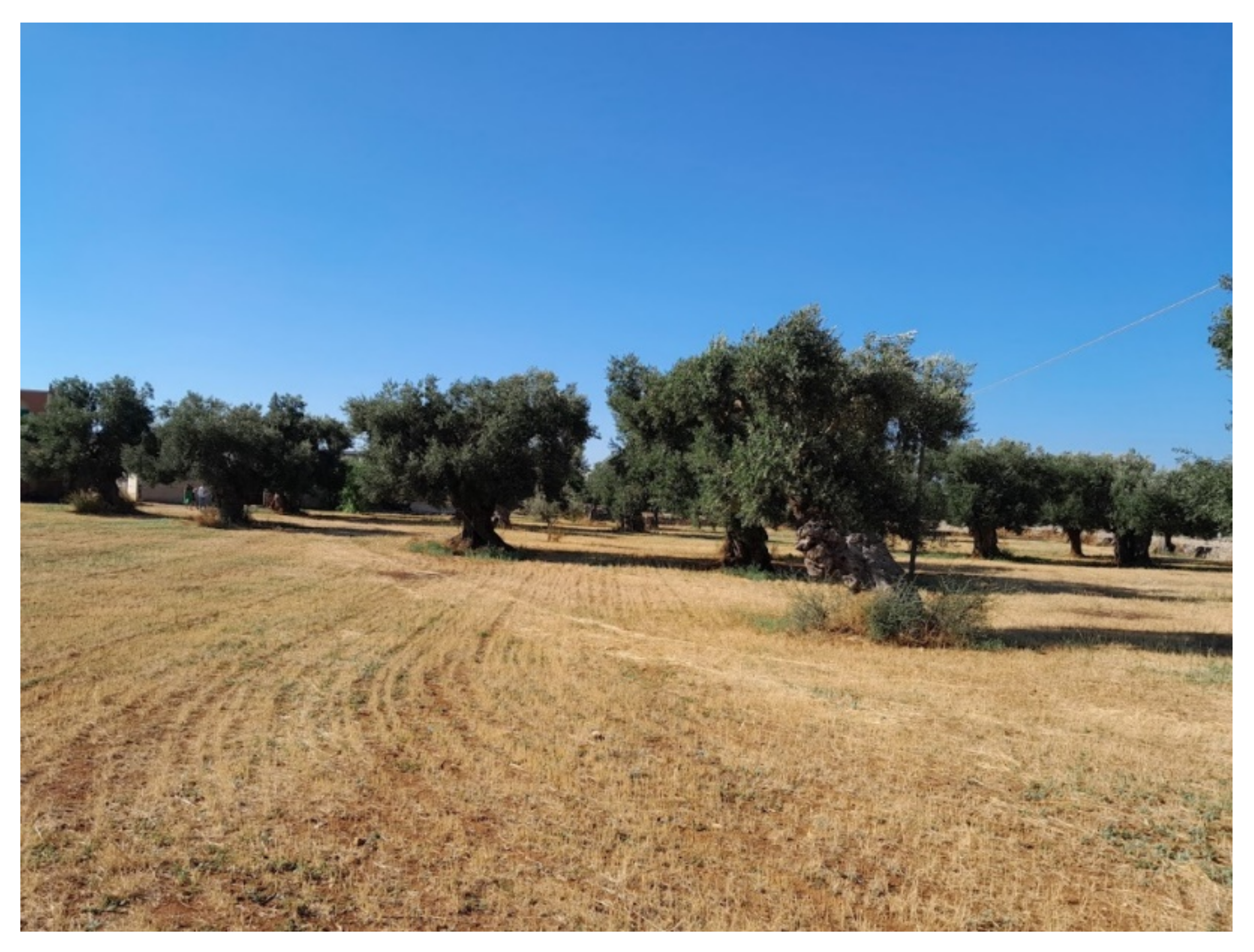
2.1. Agro-Ecological Overview of the Study Area

The southern area of Apulia region (Puglia in Italian), south-eastern Italy (Figure 1c), constitutes the study area of this research. Apulia is marked by a Mediterranean climate, characterized by dry summers with a risk of drought and rainy winters with mild temperatures. Climate in Apulia is ideal for the ecology and biology of Xf vectors. Natural areas such as Mediterranean maquis (phyllirea, myrtle, mastic, juniper, cistus, rhamnus, caper, and blackberry bush) and thermophilic forests (holm oak, downy oak, Aleppo pine, strawberry tree, troy oak, Virgilian oak) are a distinctive feature of the landscape mosaic. The agricultural pattern is mainly under durum wheat (29%), followed by table and oil olives (27%), temporary forage crops (17%), and permanent grassland, pastures, and meadows (15%). Vineyards (83,000 ha) and Olive orchards (382,600 ha, 60 million plants, three million millenarian plants with impressive, crooked, and colossal trunks shapes, Scheme 1 and Scheme 2) characterize the Apulian landscape, mainly between provinces of Bari and Brindisi [10].

2.2. Conceptual Framework: Zoning and Mapping

Multi-criteria analysis was considered in this study. This methodological approach allows the schematization and simplification of complex problems using a succession of consequential phases. The aim of such methodological scheme is to set the analysis from a logical point of view (framework, criteria, and indicators) and to translate the settings of the analysis system into operational choices (calculation methods, aggregation, weighting, normalization, classification). As such, the methodological approach [20,21] used here is expressed in a cascade process as follows: (i) study of the procedural logic framework, (ii) identification of the most appropriate criteria for breaking down and simplifying the object of the analysis, (iii) identification of the indicators that explain better the pattern under analysis, (iv) calculation of indicators (this phase includes the choice of data sources, the choice of analysis format and geographic scale of investigation and the choice of spatial analysis tools for converting data into indicators), (v) analyses of data (the final stage leads to zoning).
Once the indicators (Appendix A) for each of the polygons were obtained, the classification was carried out through the K-mean clustering method. To verify the effectiveness of clustering, we used the Elbow method, a heuristic method to determine the number of clusters in a dataset. Concerning maps, we used Sentinel 2 satellite data from the European Copernicus (ESA) project. Sentinel 2 data are multispectral data with a maximum resolution of 10 m, temporal update every 5 days, completely free of charge, obtainable through dedicated platforms, and total coverage of the earth’s surface. We Multispectral maps of portions equal to 100 squares kilometres of the earth’s surface were assessed through the QGIS SCP (Semi-Automatic Classification) plugin.

2.3. Indicators Gathering and Calculation for Zoning

The zoning of the study area towards effective monitoring and surveillance of Xf vectors was elaborated through five indicators (vegetation index/NDVI, crop intensity, crop diversity, agricultural landscape, and altitude) as summarized in Appendix A. The selection of these variables was justified by: (i) representativeness of the health status of olive trees, (ii) capability to differentiate areas, and (iii) moderate discrimination ability.
Concerning vegetation index, we used Sentinel 2 satellite data from the European Copernicus (ESA) project. Sentinel 2 data are multispectral images with a maximum resolution of 10 m, temporal update every 5 days, completely free of charge, obtainable through dedicated platforms, and total coverage of the earth’s surface. Multispectral maps representing 100-square kilometers wide portions of the earth’s surface were assessed and acquired through the “Semi-Automatic Classification Plugin” (SCP) in QGIS environment. The plugin application provides tools to download, preprocess, and postprocess satellite images. As a distinctive indicator of the presence of vegetation and the health status of olives orchards that have been affected by Xf at different times, we obtained satellite images in order to calculate NDVI. Images for the Salento area (codes T33TXE, T33TXF, T33TYE, T33TYF) were Sentinel-2 MSI: MultiSpectral Instrument, Level-2A downloaded from Scihub and preprocessed using SCP plugin in QGIS 3.22 environment. We chose summer images (17 August 2021) with the aim of minimizing the interference from spontaneous vegetation or associated vegetation with olive groves as well as the cloud cover. Furthermore, this favors a clearer calculation of the NDVI value. The latter is known to assess the presence of photosynthetic activity, as it relates to the spectrum of red, in which there is absorption by chlorophyll and that of the near-infrared in which the leaves reflect light to avoid overheating. Index values are typically between −1 and +1. The presence of vegetation assumes values greater than 0.2. During particularly dry periods, the plants reduce their photosynthetic activity, thus decreasing the value of the index. The maps corresponding to the spectral bands of the near-infrared (B08) and of the visible red (B04) were used for the calculation of the NDVI on each cell with a resolution of 10 m. The polygons of the olive groves derived from the selection of the class 223 Corine Land Cover 2011 IV Liv. were subsequently overlayed with the concerned raster. We then assigned each polygon to the average NDVI value of the underlying cells.
To elicit agricultural intensity indicators [22,23,24,25], we considered data (quantity of average fertilizer per hectare, quantity of plant protection products used per hectare, hours of machine work per hectare, irrigation volumes per hectare) of the Agricultural Accounting Information Network, updated annually by the Council for Agricultural Research and Analysis of Agricultural Economics (CREA), which provide useful information on the location of the householdings under investigation and, the indication of the levels of each of the inputs included in the analysis for each crop. As such, we initially refined and georeferenced the farm microdata based on the geographical coordinates of the farm centres registered in the FADN database. The result of this phase is a point geographical database in which each georeferenced farm, surveyed by the FADN, is accompanied by information on the inputs mentioned above. Subsequently, agricultural input data were aggregated for the farms with olive groves and then normalized on values between 0 and 1. For this purpose, we used the polygons of the class 223 Corine Land Cover 2011 IV Liv. for which the value attributed to the olive groves polygons correspond to the average of the cultivation intensity.
Since Xf vectors are known to be highly polyphagous [2,5,6], crop diversity was considered another indicator for zoning. In fact, it represents the diversity of the agricultural landscape and provides a quantitative and measurable value of the presence of an agro-ecomosaic that is identifiable with a sustained diversity of the crops present in the study area. The richness of the agro-ecomosaic can be calculated starting from a diversity index. As such, we measured this indicator through the Shannon diversity index [22,23,24,25,26]. Furthermore, it exhibits moderate discriminating ability and dependence on sample size. The higher its value, the greater the degree of diversity recorded in the unit of analysis. Moreover, the Shannon index presupposes the selection of the crop typology classes to be included in the diversity analysis and the knowledge of the incidence of the surface of each class with respect to the total of the reference unit. Concretely, we initially classified the study area into 7 macro classes of land use (with a resolution of 10 m) through a 2018 processing of Sentinel 2 images. Then, we aggregated the obtained macro classes into cells of 1 square kilometre and we expressed them as a percentage of the total area of the 1 square kilometre cell. Subsequently, the Shannon index was calculated, and the linear normalization with values between 0 and 1 was carried out. We attributed to the olive groves the average of the Shannon value of the cells underlying the polygons of the class 223 Corine Land Cover 2011 IV Liv. However, we excluded these classification areas that were identifiable as “Built-up”.
The ecology and biology of Xf vectors require a relative density of agricultural landscape elements (dry stone walls, hedges, rows of trees). This zoning indicator reflects an indication of the complexity of the agricultural landscape, captures any differences in the characterization of the agroecosystem, and represents the capacity of the agricultural territory to provide shelter, food, and movement for Xf vectors [2,3,4,5,6]. As such, we initially extracted the linear agricultural landscape elements (dry stone walls, hedges, and rows of trees) from the Regional Technical Cartography of the Apulia region. Then, we calculated this indicator through the “line density” technique that returns a value in meters on the chosen surface unit, corresponding to 1 square kilometre. The values obtained are subsequently normalized to values between 0 and 1. The value attributed to each olive grove finally corresponds to the average of the normalized density index obtained with the zonal statistics applied using the polygons of class 223 Corine Land Cover 2011 IV Liv. as the spatial reference unit. Since Xf growth rates are sensitive to temperature, a suitable thermal regime is likely to be an important zoning indicator. According to Feil and Purcell [27], Xf has limited activity below 12–17 °C and does not survive above 37 °C, but its growth is rapid between 25 to 30 °C with an optimum temperature of 28°C for the epidemiology. In this context, altitude, closely related to temperature, was considered a better indicator of the zoning to which Xf and related vectors would be exposed. Zoning from altitude was assessed from the Digital Terrain Model of the Apulia region. This zoning indicator constitutes an objective physical aspect of the territory, often used in land suitability or zoning studies as a proxy for the topographical complexity of the areas studied. The database is therefore represented by a raster cartographic layer which represents the elevation of the territory with a resolution of 20 m.

2.4. Indicators Zoning Implications for Management Costs

Each indicator described above can influence the costs of management of Xf vector in terms of continuous monitoring and surveillance. As such, the NDVI is directly proportional to the increase in these costs. In fact, the presence of vital vegetation/photosynthetic activity presupposes the need for increased monitoring activities. Conversely, low NDVI levels correspond to a low presence of vegetation and, therefore, a relatively lower monitoring activity. Similarly, the cultivation intensity of olive groves corresponds to high costs due to narrower planting distances and a higher number of plants per hectare. In the same way, the presence of an ecomosaic vegetation [28,29,30,31] increases the likelihood of harboring Xf vector species and, consequently, increases monitoring management costs on account of the Xf vector(s) is/are polyphagous [2,5,6]. On the contrary, a monoculture patho-system may positively influence cost reduction. Moreover, the greater the presence of landscape elements, the higher the management costs of monitoring and surveillance of Xf vector(s) that find(s) alternative habitats in the study area. In some respects, the higher the altitude, the higher the cost of monitoring due to the associated spatial complexity.
For each zoning indicator, five different levels of costs were used, corresponding to lowest, low, absence, high or highest cost, with assigned symbols of “− − (−2), − (−1), = (0), + (+1) and + + (+2)”, respectively. Therefore, to determine the overall cost in each class, the sum “symbol” of each of the five zoning indicators was summed up. Considering that the score for each of the five indicators may vary from −9 to +10, it was established by a panel of experts that the impact level of costs impact should be considered lowest for values ranging from −9 to −6, low from −5 to −2, Medium from −1 to +2, high from +3 to +6 and, highest from +7 to +10.

3. Results

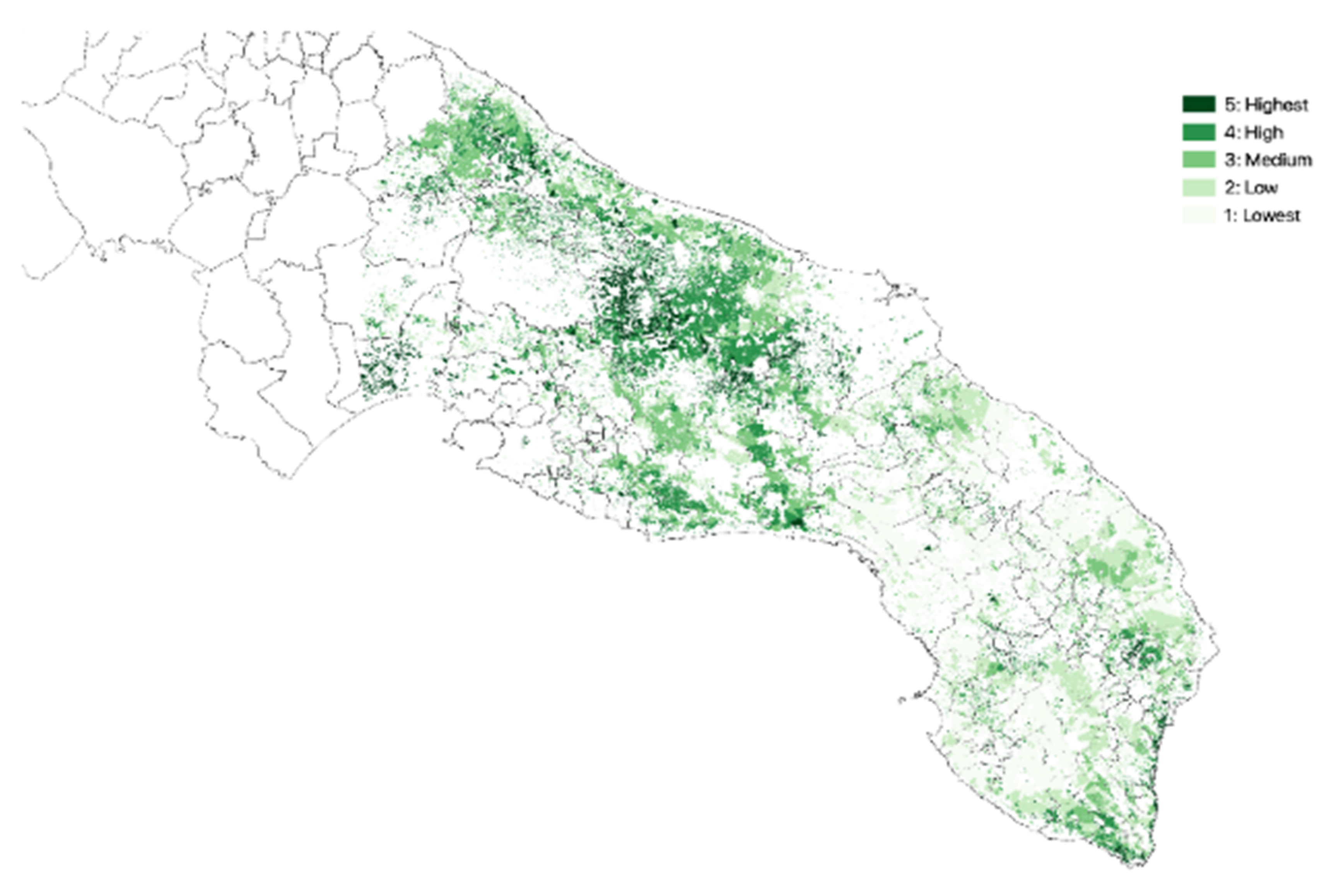
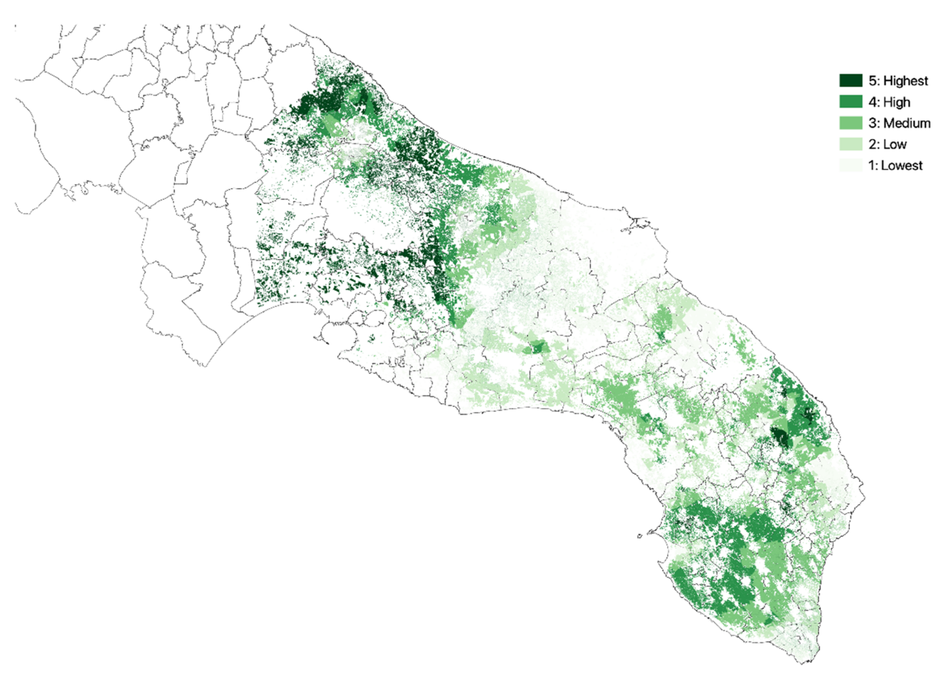
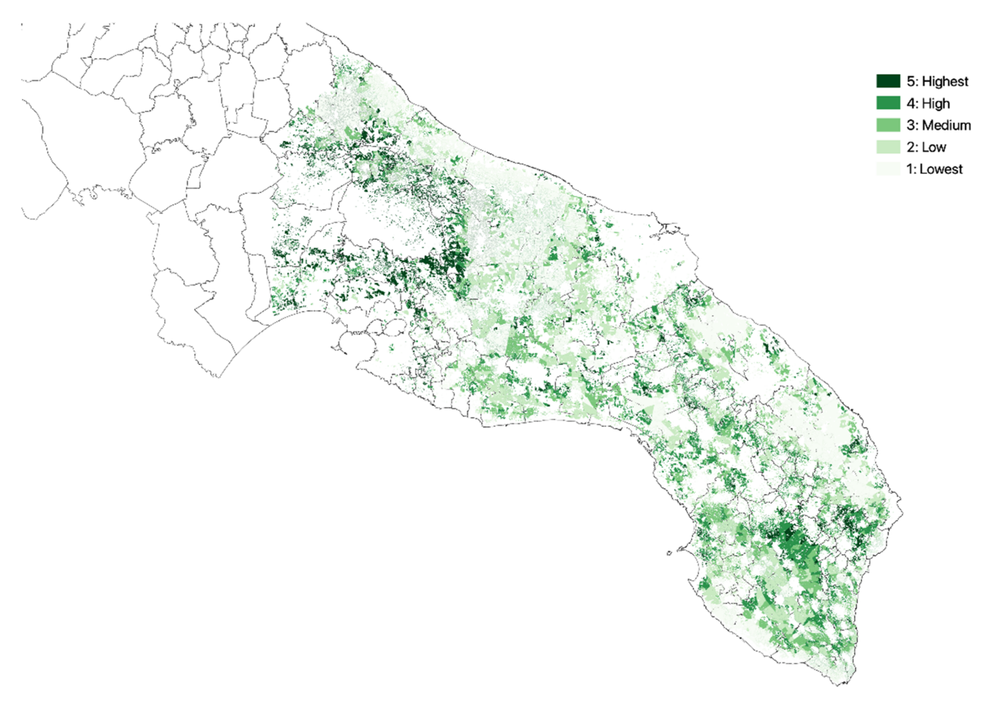
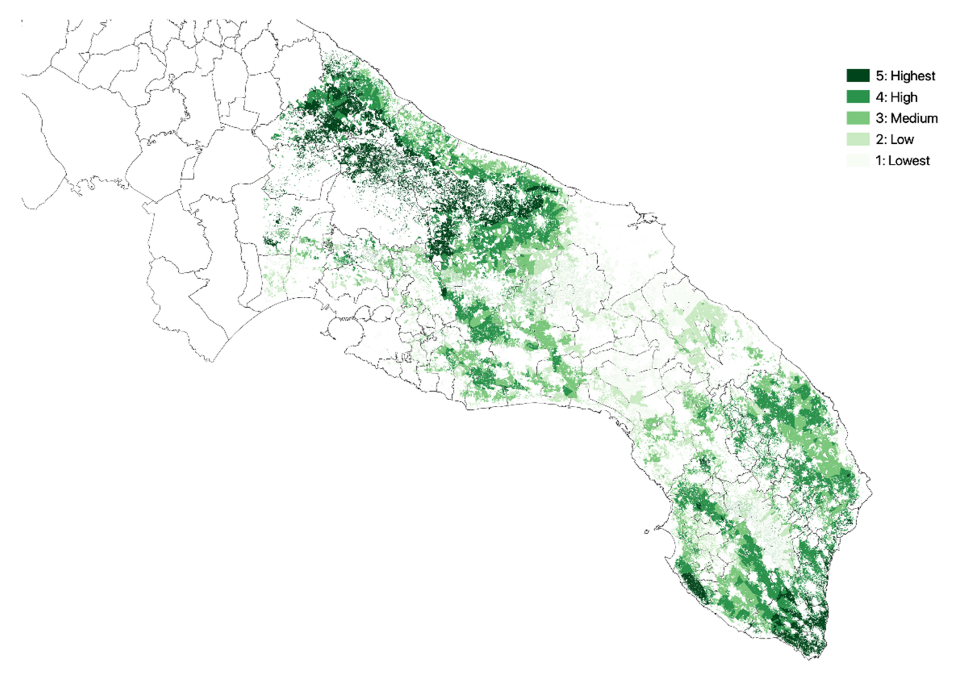
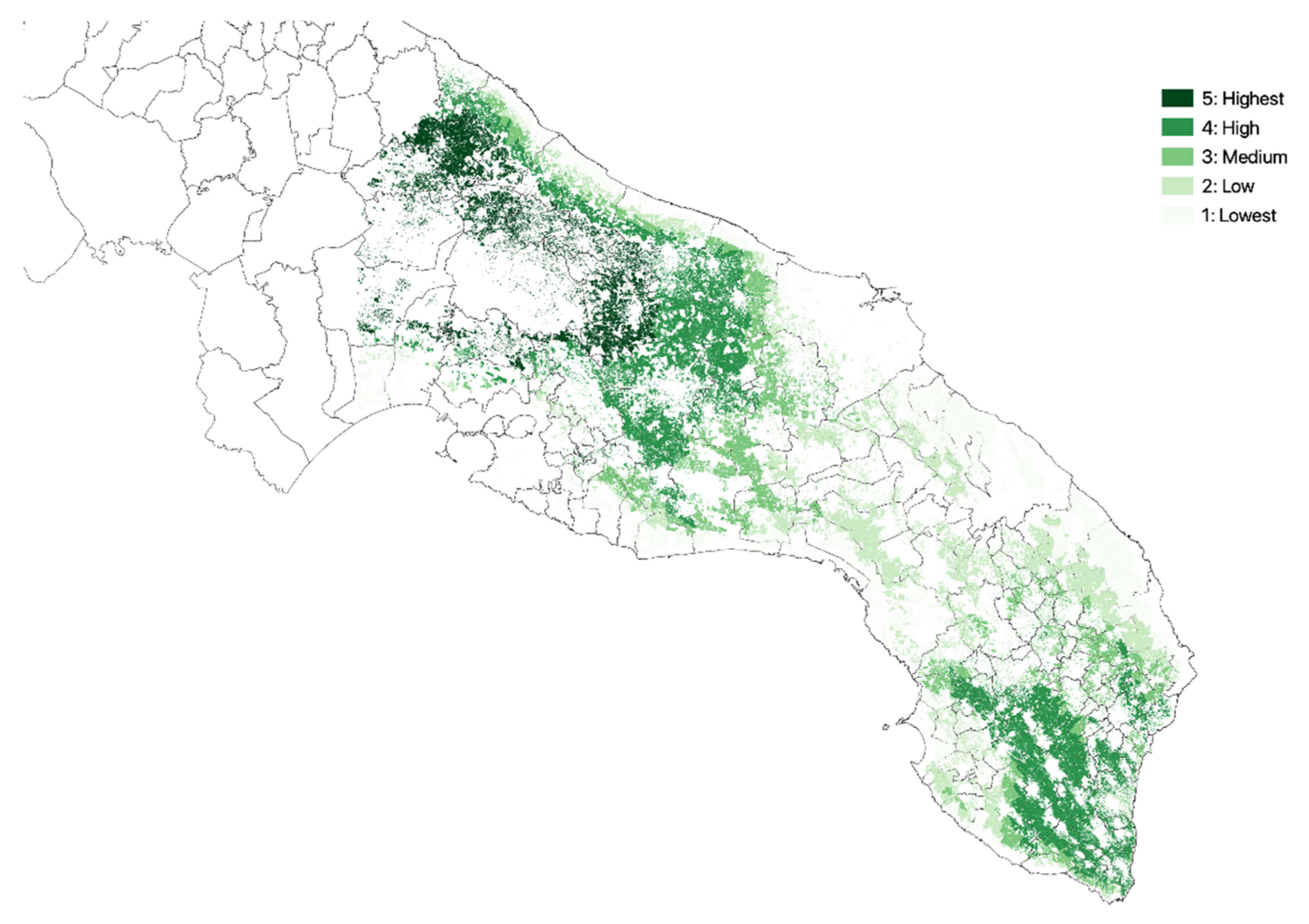
3.1. Olive Groves Indicators for Zoning
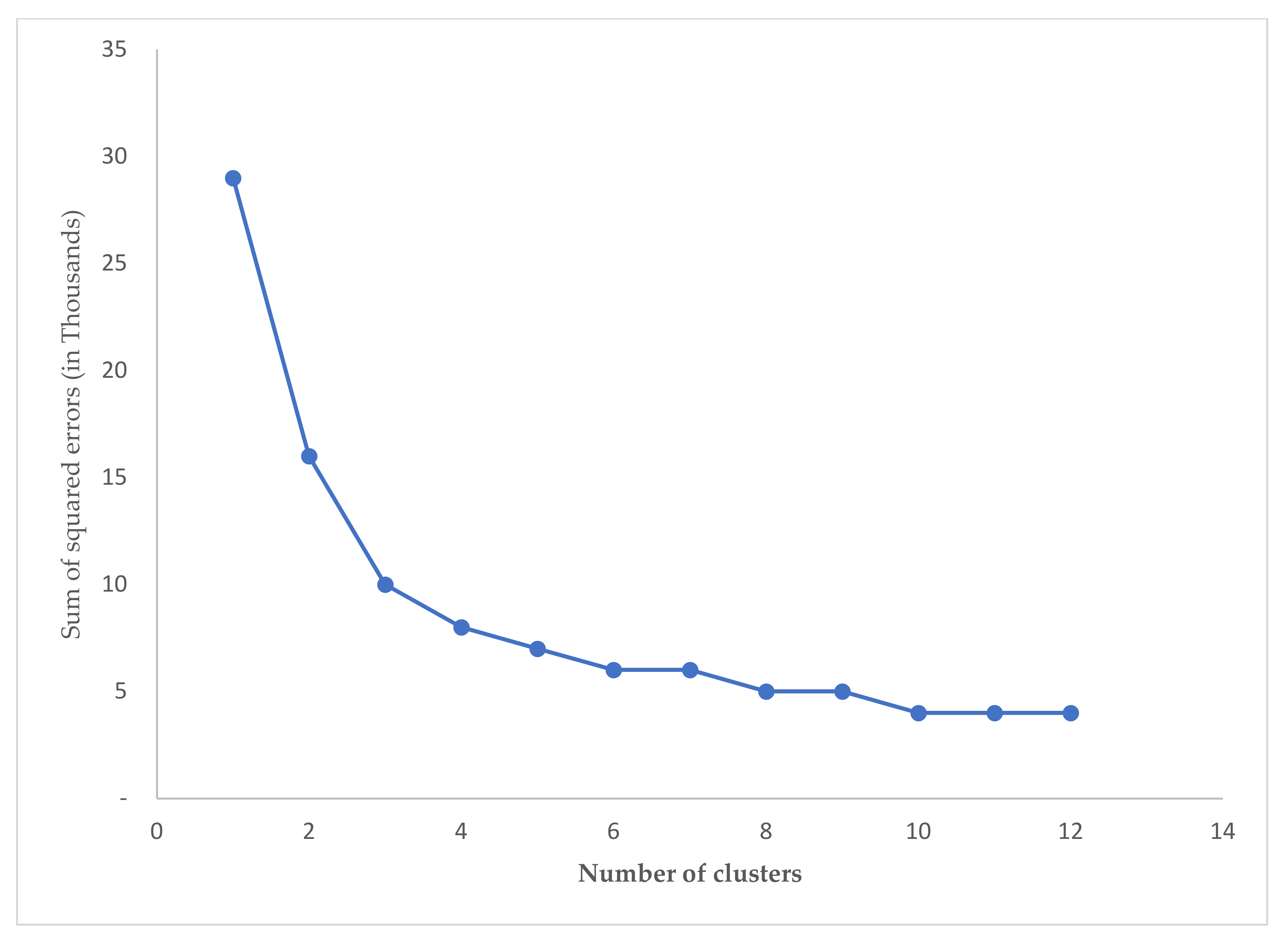
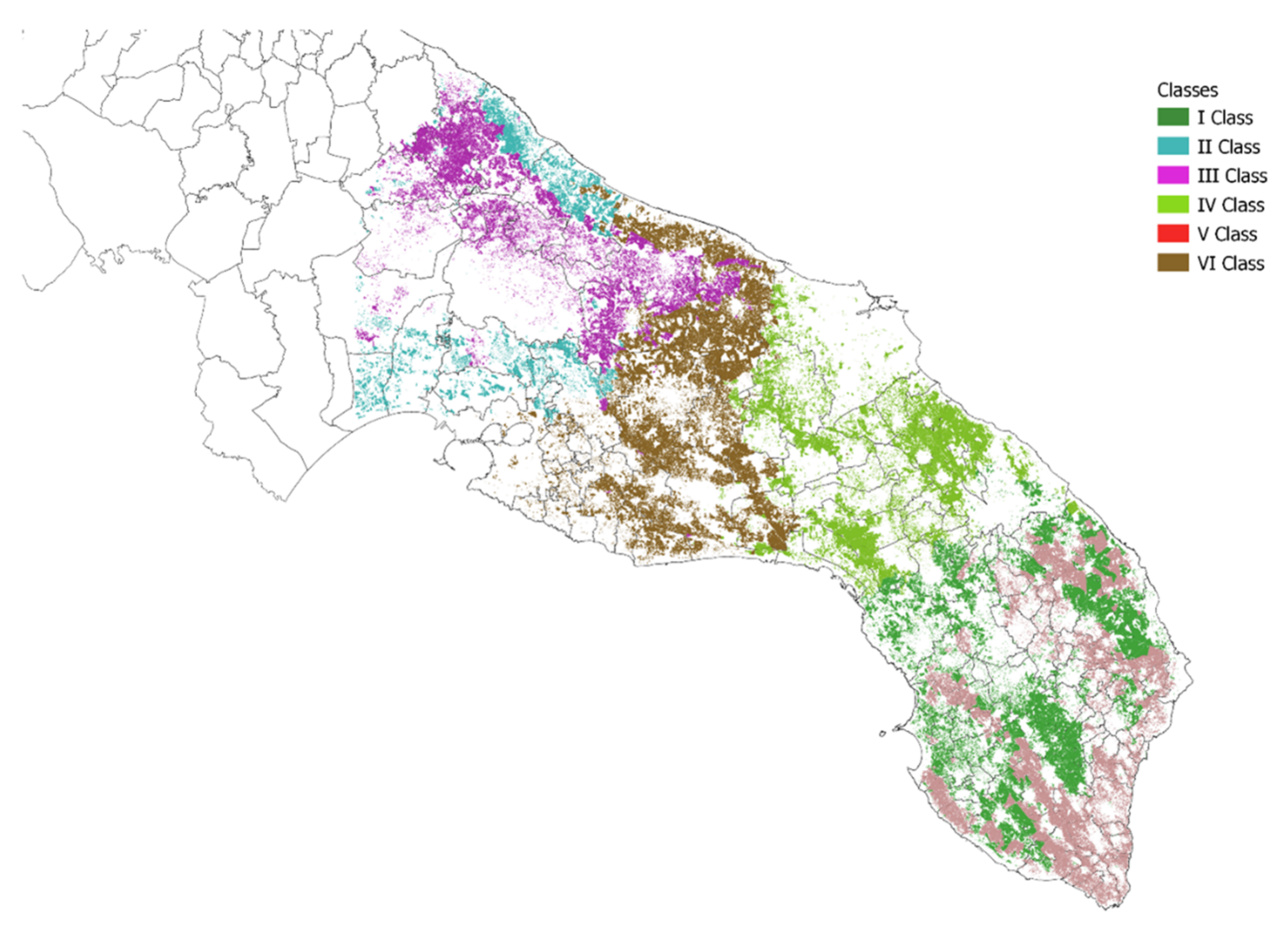
The calculation of the single indicators, subsequently used in the clustering phase, was carried out through the application of zonal statistics. The reference territorial figures for the calculation of the average value of the raster cartography obtained so far correspond to the olive groves of the Corine Land Cover 2011 IV Liv. for southern Apulia. The maps (Figure 2, Figure 3, Figure 4, Figure 5 and Figure 6) resulting from the calculation of the concerned indicators for each of the polygons falling within the study area are presented below. Concerning the crop intensity (Figure 3), on the one hand, the area with the highest average use of agricultural inputs is the upper side of the Salento area (i.e., “Arco Jonico Tarantino” and “Murgia dei Trulli”Figure 1c). On the other hand, the southern Salento presents low to lowest mean values due to very limited crop management. Regarding the vegetation diversity (Figure 4), the distribution of the cells is almost normal across the study area, with slight asymmetry in favor of the higher values. Similarly, the upper Salento area, characterized by an accentuated alternation of diversified crop types, presents the greatest crop diversity. On the contrary, this zoning indicator drops considerably as we move southwards. In terms of the density of agricultural elements (Figure 5), it is also possible to notice a high concentration of the elements of the agricultural landscape in a large area that includes the upper Salento area. In the same way, southern Salento (i.e., “Capo di Leuca” in “Salento delle Serre”) and the coastal strips that go up along the Adriatic and Ionian coasts present a high concentration of the elements of the agricultural landscape. On the contrary, the area of the Brindisi plain (i.e., “La Campagna Brindisina”) and the South-Eastern territory show a lower complexity with respect to this zoning indicator.

3.2. Zoning

The grouping of the olive groves of Southern Apulia was carried out using the K-mean method. The parameters included in the analysis are represented by the five indicators calculated in the previous phase and by the two coordinates (X and Y) of the centroids of the olive groves. The choice to include geographical attributes derives from the will to aggregate similar olive groves belonging to homogeneous and easily circumscribable geographical contexts. A preliminary analysis carried out to identify the most effective number of clusters with the “Elbow” method revealed that the previously hypothesized number of six clusters is plausible in reducing the variance within the groups. As can be seen in Figure 7, the number chosen is, in fact, in the lower part of the curve (just after the “elbow” of the hyperbola), denoting the ability of the proposed model to generate homogeneous groups. Thus, Figure 8 shows the clustering, which represents the starting point for a more accurate subdivision of the areas under study. Classes I and IV appear to intersect each other, suggesting the presence of numerical differences in the indicators that prevail over the geographical character. On the contrary, class II is divided into two portions that have a parallel territorial development and are interspersed with the block constituted by class number III. This is probably due to the homogeneity of the aspects characterizing the agricultural landscape, such as prevailing over the geographical distance of the two portions formed. Furthermore, statistical tests performed (Supplementary File S1) show that zoning with clustering guarantees an excellent differentiation over classes in general and a very good differentiation property looking at each class comparison: over 75 compared cases (15 pairs of classes per five indicators), only three cases report no significant differences.
Furthermore, while the first, located in the central-southern Salento area (Figure 8), has particularly low average NDVI values, the sixth, further north, in the territory between the provinces of Brindisi and Taranto, has as its characterizing factor above all the low crop diversity (Table 1). The second class, located both in the “Piana degli Olivi Monumentali” and in the “Arco Ionico Tarantino” (Figure 1c), is characterized by high values of NDVI, crop intensity, and crop diversity. The third class, corresponding to the “Valle d’Itria” and the “Murgia dei Trulli” (Figure 1c), obtains medium-high performances for all parameters except for the elements of the agricultural landscape, which result in an exceptionally high average density value.
On the other hand, the value of the crop intensity is more moderate, which remains on average values. The fourth class, in the province of Brindisi, is characterized by low average values with respect to the elements of the agricultural landscape. The “Piana Brindisina” (Figure 1c) is also distinguished by its low territorial elevation. The fifth class, between “Capo di Leuca” (Figure 1c) and the two coasts, with some fringes that creep inland, is characterized mainly by a high concentration of agricultural landscape elements and by the values of the other medium-low parameters.
Concerning the NDVI indicator, its value is always higher than 0.28, which coincides with the first class. The classes with the highest NDVI value are the second and third classes, which reach an average value of 0.34. As for the intensity of cultivation, the greatest value is 0.91, reached by the second class. The lowest NDVI values are expressed in the fourth and sixth classes with 0.26 and 0.28, respectively. With respect to crop intensity, the highest value is recorded by the second class, followed by the third one. The average value of normalized crop diversity is about 0.6. The average of the indicator for the second and third classes is slightly higher (0.66) while it drops to 0.53 for the sixth and 0.566 for the fifth. The normalized index of the density of linear elements of the agricultural landscape has a much wider and clearer variability between the different classes. For this indicator, the highest value is recorded in the third class with 0.89, while the lowest is in the fourth class with a value of 0.07. The average altitude of the areas considered is 125 m above sea level. The class with the highest elevation is the third with 322 m, while the fourth is the lowest with around 45 m.

3.3. Overall Impact of Zoning to Xf Vectors Management Costs

When we summed the qualitative zoning indicators symbols, like – or + (Table 2) for each cluster, class IV (−7) incurs the lowest costs for monitoring activities, mainly due to low intensity of cultivation and low landscape elements density and elevation under the average. Consequently, this class engenders easily managed costs for monitoring and surveillance of Xf vectors in the study area. On the one hand, class VI (−1) yields medium costs, but Classes I (−3) and V (−2) yield the low costs of combined indicators owing to the low averages value of NDVI, the intensity of cultivation, and crop diversity as well as the altitude. On the contrary, Classes II (+7) and III (+9) present the highest cost level due to the highest average values of the concerned zoning indicators.

4. Discussion

Clustering, as a multi-spatial methodological approach [32,33], elicit the effect of vegetation traits and landscape structure on animal diversity and allows for a better understanding of an ongoing alien-biota invasion like Xf, as well as for its effective monitoring and surveillance management costs. Based on this visual evidence [34,35,36], our assessment of the combination of six indicators provides a useful tool for local authorities by clustering the study area into six zones. Across these zones, our analysis identifies a total of close to 29 thousand polygons (Table 3) that are attributable to olive groves in the study area with a total area and total average of 235,940 and 8.14 Ha, respectively. On the one hand, class II presents the lowest number of polygons, while the first one has the highest number with 21% of the total number of polygons. In the same way, class VI presents the largest average size of olive groves (12.57 Ha).
Furthermore, the discriminating capacity of the proposed model is, in fact, reflected in the identification of classes that differ in one or more characteristics considered through the inclusion of the various indicators. In fact, analysed individually, the average values of the indicators show behaviours capable of adequately distinguishing the six classes. The distinction of the two classes presumably occurs only because of the inclusion of the geographic parameters of longitude and latitude that differentiate their location within the area considered. As such, the findings investigated here provide a clear map of the different classes that differ effectively on account of cultivation, landscape aspects, and agricultural agroecosystem features. As such, our results are consistent with Santoeimma et al. [37], who stressed that zones at higher altitudes in cooler ambient olive groves might favor the abundance and persistence of Ps and consequently influence its surveillance and monitoring costs. Regarding the crop diversity indicator, our findings are also in line with White et al. [38], who reported that landscape mosaics act as spread driver of Xf vector on account of a pattern of non-olive habitat (i.e., presence of Nerium oleander, coastal rosemary, stone fruits, Polygala myrtifolia, etc.) that also may increase in risk damages for the landscape.
Proposed zoning may help better understand and quantify the interaction among the actors of extant, actual, or future events. The available studies on invasive species’ intrinsic dispersive zonal attitude in the territory [39] will help verify the expected control results. The proposal here counteracts the analysis from Strona [40], revealing a not-so-homogenous plant network. We presume an influx at each passage from zone to zone and consequent sufferance for pests with a pronounced dispersive attitude. Mitigation of pests strongly driven by semiochemical, or VOCs [41,42,43] will suggest the attempt to lure and concentrate them in the zone with scarce or absent resources or to interfere [44], modifying the interaction with the host or food plants. The interference will result in lower fitness and premature death, eventually.
Dispersion and the role of pests can depend on functional ecological corridors, either natural or artificial. Today examples are the dispersion of Asian Psyllids [45], Aleurocanthus spiniferus infesting grape [46], or Kermesidae infesting to death urban oaks [47]. Zoning use and efficacy will change because of the pest’s polyphagy, oligophagy, or monophagy [48].
Different impacts and damage also originate from insect-carried or vectored plants’ endophytes or pathogens [49] like bacteria [50] or nematodes [51] with symbiotic or opportunistic attitudes to behave as insect-borne plant pathogens.
Luckily enough, functional human-managed host plants’ ecological corridors also facilitate the acclimation and spread of useful alien pest antagonists [52] that are a possible option for biocontrol action [53,54]. Unfortunately, the long time to react in case of alien organism entrance [55,56,57] causes relevant damage to target plants.
Further, the zoning explored here is linked to management costs measures, mainly those related to the surveillance and monitoring of Xf vectors in the study area and derive private and public considerations from our findings (Table 2). The composition configuration and variability of an ecosystem such olive landscape must be considered for effective management of plant diseases [34,58]. In fact, the costs to be incurred by farmers in implementing the control measures are all attributable to farm-specific costs such as crop operations, fuel, energy, and plant protection products.
As such, understanding the variety of sites, in terms of habitat suitability [59], and landscape features, structure, and vegetation compartments must influence the population of Ps and, consequently, be considerable for Xf vectors monitoring and surveillance [60,61]. Apulian farmers can undergo considerable increases that can negatively affect the farm gross margin. FADN’s surveys of olive farms from 2016 to 2020 led to estimate these costs at an average of EUR 287/ha per year (representing about 22% of the total saleable product). Likewise, farm production is affected not only by the direct effect of Xf on infected plants but also by the influence of numerous characteristics attributable to the landscape and vegetation choices.
Depending on the structural, phytosanitary, topographical, cultivation, and landscape conditions of the olive farms, there will be a different impact on specific costs and productivity, with a consequent effect on the gross farm margin, which for olive cultivation for oil olives in Apulia is estimated to be an annual average of EUR 949/ha over the last five years. Hence, our results match with other researchers who have also explored the importance of spatial variability of the plant disease infection and incidence and its implications on control strategies and cost-effective management [35,36,62,63,64].

5. Conclusions

In this study, we have elaborated a cluster approach based on previous research [20,21], in which the cost-effective management options are likely to be contingent upon the knowledge of vegetation traits and landscape diversity [65,66,67,68,69]. Zoning and modelling the spread of an infected area by an alien biota such as Xf are generally used to guide the management of its biological invasion [38,70]. Meanwhile, due to the wide host range (crop diversity and landscape elements) of the bacterium and its insect vectors, key strategies based on an integrated management approach must be adopted to attenuate the spread of Xf and/or control Xf outbreaks, such as continuous monitoring and inspection [71], certification, screen-house production, and clean (Xf-free) propagation material, aiming to the economic feasibility of this technical approach.
Further similar research in many regions around the globe would contribute to the vital management strategies to reduce vector populations and minimize thus Xf transmission and disease incidence. A better understanding of the interactions and quantifying the impact of the actors over the territory will help estimate the effects of invasive, advantageous, or harmful species. The cost at each zone passage is interesting to evaluate and to use as a control mean, mainly versus pests with a robust dispersive attitude. Semiochemicals or VOCs [41,42,43] use is also a low impact and sustainable asset of interesting management actions to modify host/food plant to pest interaction. Using ecological corridors as functional zones to control is also an exciting option. Within this context, the identification of landscape and vegetation patterns could further enable the generation of low-cost Xf vector surveys, in particular within countries with a high risk for Xf exposure to invasion [7].

Supplementary Materials

The following supporting information can be downloaded at: https://www.mdpi.com/article/10.3390/land11071105/s1, File S1: Analysis of variance.

Author Contributions

Conceptualization, F.B., M.F., V.F., G.C., P.F.G., S.G. and A.P.; Methodology, F.B., M.F., V.F., G.C. and A.P.; Software, A.P. and M.F.; Validation, M.F.,V.F., A.P. and F.B.; Formal Analysis, A.P. and M.F.; Investigation, A.P., M.F. and G.C.; Data Curation, M.F. and A.P.; Writing—Original Draft Preparation, M.F. and A.P.; Writing—Review and Editing, M.F., A.P., V.F., G.C. and F.B.; Visualization, M.F.; Supervision, V.F. and F.B.; Funding acquisition, P.F.G. and S.G.; Project Administration, P.F.G., S.G. and A.P. All authors have read and agreed to the published version of the manuscript.

Funding

This research was funded by the European Cooperation Program Interreg VA Greece–Italy 2014/2020. BEST project. Addressing joint Agro and Aqua-Biodiversity pressures Enhancing SuSTainable Rural Development. Budget: 5,380,000.00 €.

Institutional Review Board Statement

Not applicable.

Informed Consent Statement

Not applicable.

Data Availability Statement

Not applicable.

Acknowledgments

Thanks are due to Enza Campanella for her technical assistance.

Conflicts of Interest

The authors declare that there is no conflict of interest.

Appendix A

Table A1. Indicators used to cluster overall Xylella fastidiosa vectors spread in the study area.
Indicator and DescriptionSource of Data and Mode of Calculation
Vegetation index:
Presence of vegetation
Satellite images produced by sensors that acquire in the red (R: 0.7 µm) and near infrared (NIR: 0.9 µm).
Vegetation index is calculated with the following formula:
NDVI = NIR R NIR + R
Crop intensity:
Level of agricultural use inputs (water, mechanization, fertilizers, and pesticides)
Georeferenced microdata by Farm Accountancy Data Network (FADN) aggregated at farm level and interpolated on a landscape scale according to Inverse Distance Weighting technique.
Interpolated value u at a given point (x) is:
Where:
u x = i = 1 N ω i x u i i = 1 N ω i x u i ,
If d(x,xi) ≠ 0 for all i
If d(x,xi) = 0 for some i
Where:
ω i = 1 d x , x i p
Is a weighting function in which: x denotes an interpolated (arbitrary) point, xi is an interpolating (known) point, d is a given distance from the known point xi to the unknown point x, N is the total number of known points used in interpolation and p is a positive real number, called the power parameter related to the aggregated and normalized value of agricultural inputs.
Crop diversity:
Agricultural landscape structure
Shannon index calculated using crop typology classes incidence in each cell according to the following formula:
H = C j = 1 s p j   l n   p j
where:
C: constant equal to 1;
Pj: percentage incidence of the surface of class J with respect to the total;
s: number of classes of crop types
J: J-th crop typology class
Density of agricultural landscape elements: Complexity of the agricultural landscape dry (stone walls, hedges, rows of tree)Normalized relative value of the length of the elements of the agricultural landscape extracted from Regional Technical Map of Apulia and referred to the landscape reference unit
Altitude:
Elevation from sea level
Digital Terrain Model of the Apulia region in meters above sea level on a raster file 20 × 20 m.

References

  1. Wells, J.M.; Raju, B.C.; Hung, H.Y.; Weisburg, W.G.; Mandelco-Paul, L.; Brenner, D.J. Xylella fastidiosa gen. nov., sp. nov.: Gram-negative, xylem-limited, fastidious plant bacteria related to Xanthomonas spp. Int. J. Syst. Bacteriol. 1987, 37, 136–143. [Google Scholar] [CrossRef]
  2. European Food Safety Authority Panel on Plant Health. Scientific opinion on the risks to plant health posed by Xylella fastidiosa in the EU territory, with the identification and evaluation of risk reduction options. EFSA J. 2015, 13, 3989. [Google Scholar] [CrossRef]
  3. European Food Safety Authority Panel on Plant Health. Update of the scientific opinion on the risks to plant health posed by Xylella fastidiosa in the EU territory. EFSA J. 2019, 17, 5665. [Google Scholar] [CrossRef]
  4. Bucci, E.M. Xylella fastidiosa, a new plant pathogen that threatens global farming: Ecology, molecular biology, search for remedies. Biochem. Biophys. Res. Commun. 2018, 502, 173–182. [Google Scholar] [CrossRef]
  5. Delbianco, A.; Gibin, D.; Pasinato, L.; Morelli, M. Update of the Xylella spp. host plant Database-Systematic literature search up to 31 December 2020. EFSA J. 2021, 19, 6674. [Google Scholar] [CrossRef]
  6. Morelli, M.; García-Madero, J.M.; Jos, Á.; Saldarelli, P.; Dongiovanni, C.; Kovacova, M.; Saponari, M.; Baños Arjona, A.; Hackl, E.; Webb, S. Xylella fastidiosa in olive: A review of control attempts and current management. Microorganisms 2021, 9, 1771. [Google Scholar] [CrossRef]
  7. Frem, M.; Chapman, D.; Fucilli, V.; Choueiri, E.; El Moujabber, M.; La Notte, P.; Nigro, F. Xylella fastidiosa invasion of new countries in Europe, the Middle East, and North Africa: Ranking the potential exposure scenarios. NeoBiota 2020, 59, 77–97. [Google Scholar] [CrossRef]
  8. Cardone, G.; Digiaro, M.; Djelouah, K.; El Bilali, H.; Frem, M.; Fucilli, V.; Ladisa, G.; Rota, C.; Yaseen, T. Potential socio-economic impact of Xylella fastidiosa in the Near East and North Africa (NENA): Risk of introduction and spread, risk perception and socio-economic effects. New Medit. 2021, 20, 27–51. [Google Scholar] [CrossRef]
  9. Frem, M.; Fucilli, V.; Nigro, F.; El Moujabber, M.; Abou Kubaa, R.; La Notte, P.; Bozzo, F.; Choueiri, E. The potential direct economic impact and private management costs of an invasive alien species: Xylella fastidiosa on Lebanese wine grapes. NeoBiota 2021, 70, 43–67. [Google Scholar] [CrossRef]
  10. Frem, M.; Santeramo, F.G.; Lamonaca, E.; El Moujabber, M.; Choueiri, E.; La Notte, P.; Nigro, F.; Bozzo, F.; Fucilli, V. Landscape restoration due to Xylella fastidiosa invasion in Italy: Assessing the hypothetical public’s preferences. NeoBiota 2021, 66, 31–54. [Google Scholar] [CrossRef]
  11. Cavalieri, V.; Dongiovanni, C.; Tauro, D.; Altamura, G.; Di Carolo, M.; Fumarola, G.L.; Saponari, M.; Bosco, D. Transmission of the Codiro strain of Xylella fastidiosa by different insect species. In Proceedings of the XI European Congress of Entomology, Naples, Italy, 2–6 July 2018. [Google Scholar] [CrossRef]
  12. Lopes, S.A.; Marcussi, S.; Torres, S.C.Z.; Souza, V.; Fagan, C.; França, S.C.; Fernandes, N.G.; Lopes, J.R.S. Weeds as alternative hosts of the citrus, coffee, and plum strains of Xylella fastidiosa in Brazil. Plant Dis. 2003, 87, 544–549. [Google Scholar] [CrossRef] [Green Version]
  13. Cornara, D.; Cavalieri, V.; Dongiovanni, C.; Altamura, G.; Palmisano, F.; Bosco, D.; Porcelli, F.; Almeida, R.P.P.; Saponari, M. Transmission of Xylella fastidiosa by naturally infected Philaenus spumarius (hemiptera, aphrophoridae) to different host plants. J. Appl. Entomol. 2017, 141, 80–87. [Google Scholar] [CrossRef]
  14. López, M.M.; Narco-Noales, E.; Peñalver, J.; Morente, C.; Monterde, A. The world threat of Xylella fastidiosa. In Xylella fastidiosa & the Olive Quick Decline Syndrome (OQDS). A Serious Worldwide Challenge for the Safeguard of Olive Trees; D’Onghia, A.M., Brunel, S., Valentini, F., Eds.; Options Méditerranéennes; CIHEAM: Bari, Italy, 2017; 172p. [Google Scholar]
  15. Sun, Q.; Sun, Y.; Walker, M.A.; Labavitch, J.M. Vascular occlusions in grapevines with Pierce’s disease make disease symptom development worse. Plant Physiol. 2013, 161, 1529–1541. [Google Scholar] [CrossRef] [PubMed] [Green Version]
  16. Orusa, T.; Orusa, R.; Viani, A.; Carella, E.; Borgogno Mondino, E. Geomatics and EO Data to Support Wildlife Diseases Assessment at Landscape Level: A Pilot Experience to Map Infectious Keratoconjunctivitis in Chamois and Phenological Trends in Aosta Valley (NW Italy). Remote Sens. 2020, 12, 3542. [Google Scholar] [CrossRef]
  17. Metzger, J.P.; Muller, E. Characterizing the complexity of landscape boundaries by remote sensing. Landsc. Ecol. 1996, 11, 65–77. [Google Scholar] [CrossRef] [Green Version]
  18. Frohn, R.C. Remote Sensing for Landscape Ecology: New Metric Indicators for Monitoring, Modeling, and Assessment of Ecosystems, 1st ed.; CRC Press: Boca Raton, FL, USA, 1997. [Google Scholar] [CrossRef]
  19. Ding, Y.F.; Wang, G.Y.; Fu, E.P.; Shu, C. The role of miR398 in plant stress responses. Hereditas 2010, 32, 129–134. [Google Scholar] [CrossRef]
  20. Bozzo, F.; Fucilli, V.; Petrontino, A.; Girone, S. Identification of high nature value farmland: A methodological proposal. Ital. Rev. Agric. Econ. 2019, 74, 29–41. [Google Scholar]
  21. Petrontino, A.; Fucilli, V. High nature value forests identification: A case study in Apulia region—Italy. Aestimum 2013, 62, 67–88. [Google Scholar]
  22. Turner, B.L.; Doolittle, W.E. The concept and measure of agricultural intensity. Prof. Geogr. 1978, 30, 297–301. [Google Scholar] [CrossRef]
  23. Temme, A.J.A.M.; Verburg, P.H. Mapping and modelling of changes in agricultural intensity in Europe. Agric. Ecosyst. Environ. 2011, 140, 46–56. [Google Scholar] [CrossRef]
  24. Teillard, F.; Allaire, G.; Cahuzac, E.; Leger, F.; Maigne, E.; Tichit, M. A novel method for mapping agricultural intensity reveals its spatial aggregation: Implications for conservation policies. Agric. Ecosyst. Environ. 2012, 149, 135–143. [Google Scholar] [CrossRef]
  25. Dietrich, J.P.; Schmitz, C.; Müller, C.; Fader, M.; Lotze-Campen, H.; Popp, A. Measuring agricultural land-use intensity–A global analysis using a model-assisted approach. Ecol. Modell. 2012, 232, 109–118. [Google Scholar] [CrossRef]
  26. Shannon, C.; Weaver, W. The Mathematical Theory of Communication. Bell Syst. Tech. J. 1948, 27, 379–423. [Google Scholar] [CrossRef] [Green Version]
  27. Feil, H.; Purcell, A. Temperature-dependent growth and survival of Xylella fastidiosa in vitro and in potted grapevines. Plant Dis. 2001, 85, 1230–1234. [Google Scholar] [CrossRef] [PubMed] [Green Version]
  28. Magurran, A.E. Ecological Diversity and Its Measurement; Springer: Dordrecht, The Netherlands, 1998. [Google Scholar] [CrossRef]
  29. McCarigal, K.; Marks, B.J. Fragstats: Spatial Pattern Analysis Program for Quantifying Landscape Structure; Gen. Tech. Rep. PNW-GTR-351; US Department of Agriculture, Forest Service, Pacific Northwest Research Station: Corvallis, OR, USA, 1995; p. 122. [Google Scholar]
  30. Turner, M.G. Landscape ecology: The effect of pattern on process. Annu. Rev. Ecol. Syst. 1989, 20, 171–197. [Google Scholar] [CrossRef]
  31. Turner, M.G. Landscape ecology: What is the state of the science? Annu. Rev. Ecol. Evol. Syst. 2005, 36, 319–344. [Google Scholar] [CrossRef]
  32. Marini, L.; Fontana, P.; Battisti, A.; Gaston, K. Agricultural management, vegetation traits and landscape drive orthopteran and butterfly diversity in a grassland-forest mosaic: A multi-scale approach. Insect Conserv. Divers. 2009, 2, 213–220. [Google Scholar] [CrossRef]
  33. Raffini, F.; Bertorelle, G.; Biello, R.; D’Urso, G.; Russo, D.; Bosso, L. From nucleotides to satellite imagery: Approaches to identify and manage the invasive pathogen Xylella fastidiosa and its insect vectors in Europe. Sustainability 2020, 12, 1450. [Google Scholar] [CrossRef]
  34. Baguette, M.; Dyck, H. Landscape connectivity and animal behavior: Functional grain as a key determinant for dispersal. Landsc. Ecol. 2007, 22, 1117–1129. [Google Scholar] [CrossRef]
  35. Castrignanò, A.; Belmonte, A.; Antelmi, I.; Quarto, R.; Quarto, F.; Shaddad, S.; Sion, V.; Muolo, M.R.; Ranieri, N.A.; Gadaleta, G.; et al. A geostatistical fusion approach using UAV data for probabilistic estimation of Xylella fastidiosa subsp. pauca infection in olive trees. Sci. Total Environ. 2021, 752, 141814. [Google Scholar] [CrossRef]
  36. Castrignanò, A.; Belmonte, A.; Antelmi, I.; Quarto, R.; Quarto, F.; Shaddad, S.; Sion, V.; Muolo, M.R.; Ranieri, N.A.; Gadaleta, G.; et al. Semi-automatic method for early detection of Xylella fastidiosa in olive trees using UAV multispectral imagery and geostatistical-discriminant analysis. Remote Sens. 2021, 13, 14. [Google Scholar] [CrossRef]
  37. Santoiemma, G.; Tamburini, G.; Sanna, F.; Mori, N.; Marini, L. Landscape composition predicts the distribution of Philaenus spumarius, vector of Xylella fastidiosa, in olive groves. J. Pest Sci. 2019, 92, 1101–1109. [Google Scholar] [CrossRef] [Green Version]
  38. White, S.M.; Bullock, J.M.; Hooftman, D.A.P.; Chapman, D.S. Modelling the spread of Xylella fastidiosa in the early stages of invasion in Apulia, Italy. Biol. Invasions 2017, 19, 1825–1837. [Google Scholar] [CrossRef] [PubMed] [Green Version]
  39. Cornara, D.; Marra, M.; Tedone, B.; Cavalieri, V.; Porcelli, F.; Fereres, A.; Purcell, A.; Saponari, M. No evidence for cicadas’ implication in Xylella fastidiosa epidemiology. Entomologia 2020, 20, 125–132. [Google Scholar] [CrossRef]
  40. Strona, G.; Carstens, C.J.; Beck, P.S.A. Network analysis reveals why Xylella fastidiosa will persist in Europe. Sci. Rep. 2017, 7, 71. [Google Scholar] [CrossRef] [PubMed]
  41. Lozano-Soria, A.; Picciotti, U.; Lopez-Moya, F.; Lopez-Cepero, J.; Porcelli, F.; Lopez-Llorca, L.V. Volatile organic compounds from Entomopathogenic and Nematophagous fungi, repel Banana Black Weevil (Cosmopolites sordidus). Insects 2020, 11, 509. [Google Scholar] [CrossRef]
  42. Dalbon, V.A.; Acevedo, J.P.M.; Ribeiro Junior, K.A.L.; Ribeiro, T.F.L.; da Silva, J.M.; Fonseca, H.G.; Santana, A.E.G.; Porcelli, F. Perspectives for Synergic Blends of Attractive Sources in South American Palm Weevil Mass Trapping: Waiting for the Red Palm Weevil Brazil Invasion. Insects 2021, 12, 828. [Google Scholar] [CrossRef] [PubMed]
  43. Sardaro, R.; Roseli, L.; Grittani, R.; Scrascia, M.; Pazzani, I.C.; Russo, V.; Garganese, F.; Porfido, C.; Diana, L.; Porcelli, F. Community preferences for the preservation of Canary Palm from Red Palm Weevil in the city of Bari. Arab. J. Plant Prot. 2019, 37, 206–211. [Google Scholar] [CrossRef]
  44. Scrascia, M.; D’Addabbo, P.; Roberto, R.; Porcelli, F.; Oliva, M.; Calia, C.; Dionisi, A.M.; Pazzani, C. Characterization of CRISPR-cas systems in Serratia marcescens isolated from Rhynchophorus ferrugineus (Olivier, 1790) (Coleoptera: Curculionidae). Microorganisms 2019, 7, 368. [Google Scholar] [CrossRef] [Green Version]
  45. Mifsud, D.; Porcelli, F. The psyllid Macrohomotoma gladiata Kuwayama, 1908 (Hemiptera: Psylloidea: Homotomidae): A Ficus pest recently introduced in the EPPO region. EPPO Bull. 2012, 42, 161–164. [Google Scholar] [CrossRef]
  46. Nugnes, F.; Laudonia, S.; Jesu, G.; Jansen, M.G.M.; Bernardo, U.; Porcelli, F. Aleurocanthus spiniferus (Hemiptera: Aleyrodidae) in some European countries: Diffusion, hosts, molecular characterization, and natural enemies. Insects 2020, 11, 4241. [Google Scholar] [CrossRef] [PubMed] [Green Version]
  47. Pellizzari, G.; Porcelli, F.; Convertini, S.; Marotta, S. Description of nymphal instars and adult female of Kermes vermilio Planchon (Hemiptera, Coccoidea, Kermesidae), with a synopsis of the European and Mediterranean species. Zootaxa 2012, 3336, 36–50. [Google Scholar] [CrossRef]
  48. Cioffi, M.; Cornara, D.; Corrado, I.; Jansen, M.G.M.; Porcelli, F. The status of Aleurocanthus spiniferus from its unwanted introduction in Italy to date. Bull. Insectol. 2013, 66, 273–281. [Google Scholar]
  49. Picciotti, U.; Lahbib, N.; Sefa, V.; Porcelli, F.; Garganese, F. Aphrophoridae Role in Xylella fastidiosa subsp. pauca ST53 Invasion in Southern Italy. Pathogens 2021, 10, 1035. [Google Scholar] [CrossRef]
  50. Scrascia, M.; Pazzani, C.; Valentini, F.; Oliva, M.; Russo, V.; D’Addabbo, P.; Porcelli, F. Identification of pigmented Serratia marcescens symbiotically associated with Rhynchophorus ferrugineus Olivier (Coleoptera: Curculionidae). Microbiol. Open 2016, 5, 883–890. [Google Scholar] [CrossRef] [Green Version]
  51. Troccoli, A.; Oreste, M.; Tarasco, E.; Fanelli, E.; De Luca, F. Mononchoides macrospiculum n. sp. (Nematoda: Neodiplogastridae) and Teratorhabditis synpapillata Sudhaus, 1985 (Nematoda: Rhabditidae): Nematode associates of Rhynchophorus ferrugineus (Oliver) (Coleoptera: Curculionidae) in Italy. Nematology 2015, 17, 953–966. [Google Scholar] [CrossRef]
  52. Petr, K.; Torsten, V.D.H. Zelus renardii (Hemiptera: Heteroptera: Reduviidae): First records from Croatia, Montenegro, and an accidental introduction to the Czech Republic. Heteroptera Pol. 2022, 6, 7–14. [Google Scholar] [CrossRef]
  53. Lahbib, N.; Picciotti, U.; Sefa, V.; Boukhris-Bouhachem, S.; Porcelli, F.; Garganese, F. Zelus renardii Roaming in Southern Italy. Insects 2022, 13, 158. [Google Scholar] [CrossRef] [PubMed]
  54. Liccardo, A.; Fierro, A.; Garganese, F.; Picciotti, U.; Porcelli, F. A biological control model to manage the vector and the infection of Xylella fastidiosa on olive trees. PLoS ONE 2020, 15, 4. [Google Scholar] [CrossRef]
  55. Bubici, G.; Prigigallo, M.I.; Garganese, F.; Nugnes, F.; Jansen, M.; Porcelli, F. First Report of Aleurocanthus spiniferus on Ailanthus altissima: Profiling of the Insect Microbiome and MicroRNAs. Insects 2020, 11, 161. [Google Scholar] [CrossRef] [Green Version]
  56. Sardaro, R.; Grittani, R.; Scrascia, M.; Pazzani, C.; Russo, V.; Garganese, F.; Porfido, C.; Diana, L.; Porcelli, F. The Red Palm Weevil in the City of Bari: A First Damage Assessment. Forests 2018, 9, 452. [Google Scholar] [CrossRef] [Green Version]
  57. Salerno, M.; Mazzeo, G.; Suma, P.; Russo, A.; Diana, L.; Pellizzari, G.; Porcelli, F. Aspidiella hartii (Cockerell 1895) (Hemiptera: Diaspididae) on yam (Dioscorea spp.) tubers: A new pest regularly entering the European part of the EPPO region. EPPO Bull. 2018, 48, 287–292. [Google Scholar] [CrossRef]
  58. Tamburini, G.; Santoiemma, G.; O’Rourke, M.E.; Bommarco, R.; Chaplin-Kramer, R.; Dainese, M.; Marini, L. Species traits elucidate crop pest response to landscape composition: A global analysis. Proc. R. Soc. B 2020, 287, 1937. [Google Scholar] [CrossRef] [PubMed]
  59. Youngquist, M.B.; Boone, M.D. Making the connection: Combining habitat suitability and landscape connectivity to understand species distribution in an agricultural landscape. Landsc. Ecol. 2014, 36, 2795–2809. [Google Scholar] [CrossRef]
  60. Avosani, S.; Tattoni, C.; Mazzoni, V.; Ciolli, M. Occupancy and detection of agricultural threats: The case of Philaenus spumarius, European vector of Xylella fastidiosa. Agric. Ecosyst. Environ. 2021, 324, 107707. [Google Scholar] [CrossRef]
  61. Bodino, N.; Demichelis, S.; Simonetto, A.; Volani, S.; Saladini, M.A.; Gilioli, G.; Bosco, D. Phenology, seasonal abundance, and host-plant association of spittlebugs (Hemiptera: Aphrophoridae) in vineyards of northwestern Italy. Insects 2021, 12, 1012. [Google Scholar] [CrossRef]
  62. Brunetti, M.; Capasso, V.; Montagna, M.; Venturino, E. A mathematical model for Xylella fastidiosa epidemics in the Mediterranean regions. Promoting good agronomic practices for their effective control. Ecol. Modell. 2020, 432, 109204. [Google Scholar] [CrossRef]
  63. Hornero, A.; Hernández-Clemente, R.; North, P.R.J.; Beck, P.S.A.; Boscia, D.; Navas-Cortes, J.A.; Zarco-Tejada, P.J. Monitoring the incidence of Xylella fastidiosa infection in olive orchards using ground-based evaluations, airborne imaging spectroscopy and Sentinel-2 time series through 3-D radiative transfer modelling. Remote Sens. Environ. 2020, 36, 111480. [Google Scholar] [CrossRef]
  64. Fierro, A.; Liccardo, A.; Porcelli, F. A lattice model to manage the vector and the infection of the Xylella fastidiosa on olive trees. Sci. Rep. 2019, 9, 8723. [Google Scholar] [CrossRef]
  65. Fahrig, L. Effects of habitat fragmentation on biodiversity. Annu. Rev. Ecol. Evol. Syst. 2003, 34, 487–515. [Google Scholar] [CrossRef] [Green Version]
  66. Sanna, F.; Mori, N.; Santoiemma, G.; D’Ascenzo, D.; Scotillo, M.A.; Marini, L. Ground cover management in olive groves reduces populations of Philaenus spumarius (Hemiptera: Aphrophoridae), vector of Xylella fastidiosa. J. Econ. Entomol. 2021, 114, 1716–1721. [Google Scholar] [CrossRef] [PubMed]
  67. Scortichini, M. Predisposing factors for “olive quick decline syndrome” in Salento (Apulia, Italy). Agronomy 2020, 10, 1445. [Google Scholar] [CrossRef]
  68. Weiers, S.; Bock, M.; Wissen, M.; Rossner, G. Mapping and indicator approaches for the assessment of habitats at different scales using remote sensing and GIS methods. Landsc. Urban Plan. 2004, 67, 43–65. [Google Scholar] [CrossRef]
  69. Chapman, D.; Purse, B.; Roy, H.; Bullock, J. Global trade networks determine the distribution of invasive non-native species. Glob. Ecol. Biogeogr. 2017, 26, 907–917. [Google Scholar] [CrossRef]
  70. Kottelenberg, D.; Hemerik, L.; Saponari, M.; van der Werf, W. Shape and rate of movement of the invasion front of Xylella fastidiosa spp. pauca in Puglia. Sci. Rep. 2021, 11, 1061. [Google Scholar] [CrossRef] [PubMed]
  71. El Handi, K.; Hafidi, M.; Sabri, M.; Frem, M.; El Moujabber, M.; Habbadi, K.; Haddad, N.; Benbouazza, A.; Abou Kubaa, R.; Achbani, E.H. Continuous pest surveillance and monitoring constitute a tool for sustainable agriculture: Case of Xylella fastidiosa in Morocco. Sustainability 2022, 14, 1485. [Google Scholar] [CrossRef]
Figure 1. Location of the study area, Apulia Region, extremely damaged by Xylella fastidiosa.
Land 11 01105 g001
Scheme 1. Olive colossal trunks shape in Monopoli, Masseria Curatori. Source: Michel Elias Frem, 2022.
Land 11 01105 sch001
Scheme 2. Olive landscape in Monopoli, Masseria Curatori. Source: Michel Elias Frem, 2022.
Land 11 01105 sch002
Figure 2. Average NDVI value of the olive groves of the study area.
Land 11 01105 g002
Figure 3. Average value of the crop intensity in the olive groves of the study area.
Land 11 01105 g003
Figure 4. Average value of the crop diversity in the olive groves of the study area.
Land 11 01105 g004
Figure 5. Average value of the density of agricultural elements of the study area.
Land 11 01105 g005
Figure 6. Average value of the altitude of the study area.
Land 11 01105 g006
Figure 7. Evaluation of the optimal number of classes according to the Elbow method.
Land 11 01105 g007
Figure 8. Zoning of the study area based on the K-mean method.
Land 11 01105 g008
Table 1. Average values of the indicators for each class identified.
ClassNDVICrop
Intensity
Crop DiversityDensity of Agricultural Landscape ElementsAltitude
I0.2860.3710.5740.25963.391
II0.3410.9170.6640.308147.110
III0.3440.5830.6640.897322.897
IV0.3000.2670.5940.07445.242
V0.2950.3330.5600.69290.775
VI0.3250.2860.5370.26285.650
Table 2. Qualitative impact of the zoning indicators on the management costs of Xylella fastidiosa vectors in the study area.
ClassNDVICrop
Intensity
Crop DiversityDensity of Agricultural Landscape ElementsAltitude
I==
II+ ++ ++ +=+
III+ +++ ++ ++ +
IV− −=− −− −
V+=
VI+==
− −: Lowest impact; −: Low impact; =: Medium impact; +: High impact; + +: Highest impact.
Table 3. Structural characteristics of the identified classes in the olive groves.
ClassNumber of PolygonsTotal Area
(Ha)
Average
(Ha)
I6049.0048,253.477.98
II2675.0016,503.126.17
III5757.0033,833.385.88
IV5581.0039,791.257.13
V4509.0042,205.809.36
VI4403.0055,352.7312.57
Total28,974235,9408.14
Publisher’s Note: MDPI stays neutral with regard to jurisdictional claims in published maps and institutional affiliations.

